Reservoir Dam Surface Deformation Monitoring by Differential GB-InSAR Based on Image Subsets


Abstract
1. Introduction
2. Multi-Threshold Strategy for Coherent Point Target Selection
2.1. Extraction of Candidate Points Using Double Thresholds of Average TSNR and Average Coherence
2.2. Removal of Low-Quality GB-SAR Images
2.3. ADI Threshold Method for CPT Screening
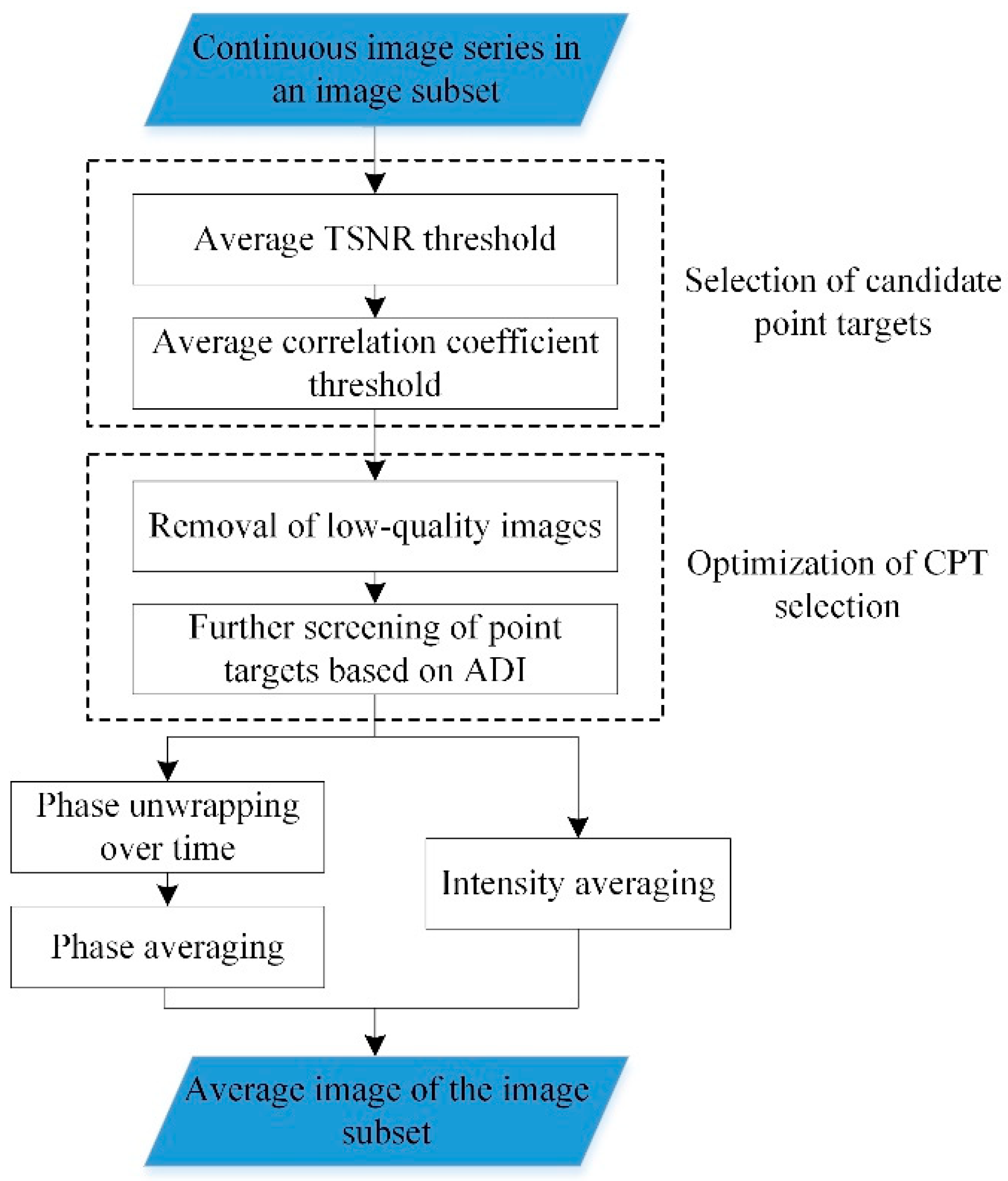
3. Differential GB-InSAR Based on Image Subsets
3.1. Calculation of Average Image of an Image Subset
3.2. Differential GB-SAR Interferometry Model Using Averaged Image of Image Subset
3.3. Atmospheric Correction Using Irregular Triangular Network
3.4. Deformation Calculation Using Weighted Least Squares Method
4. Experimental Analysis
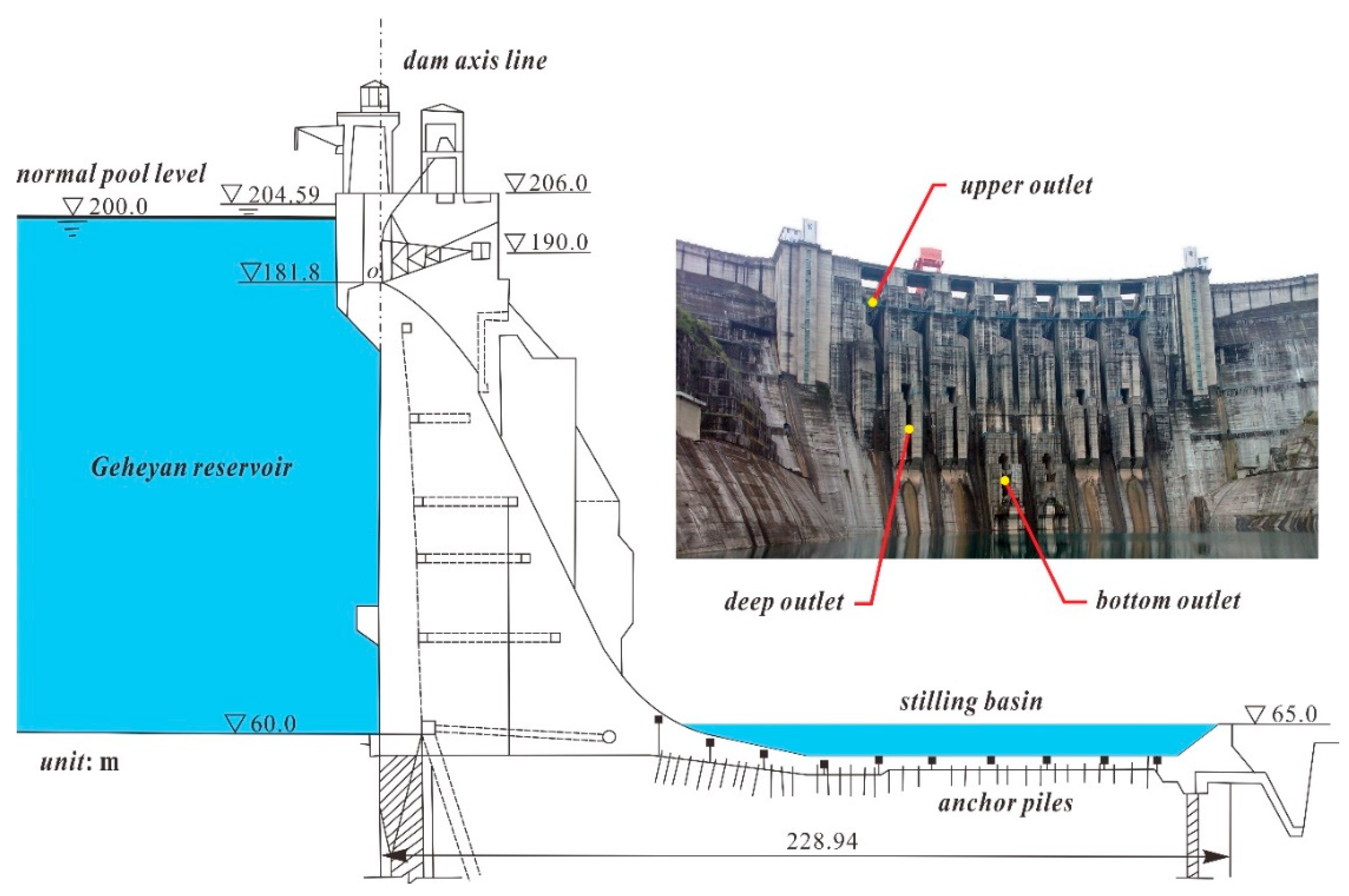
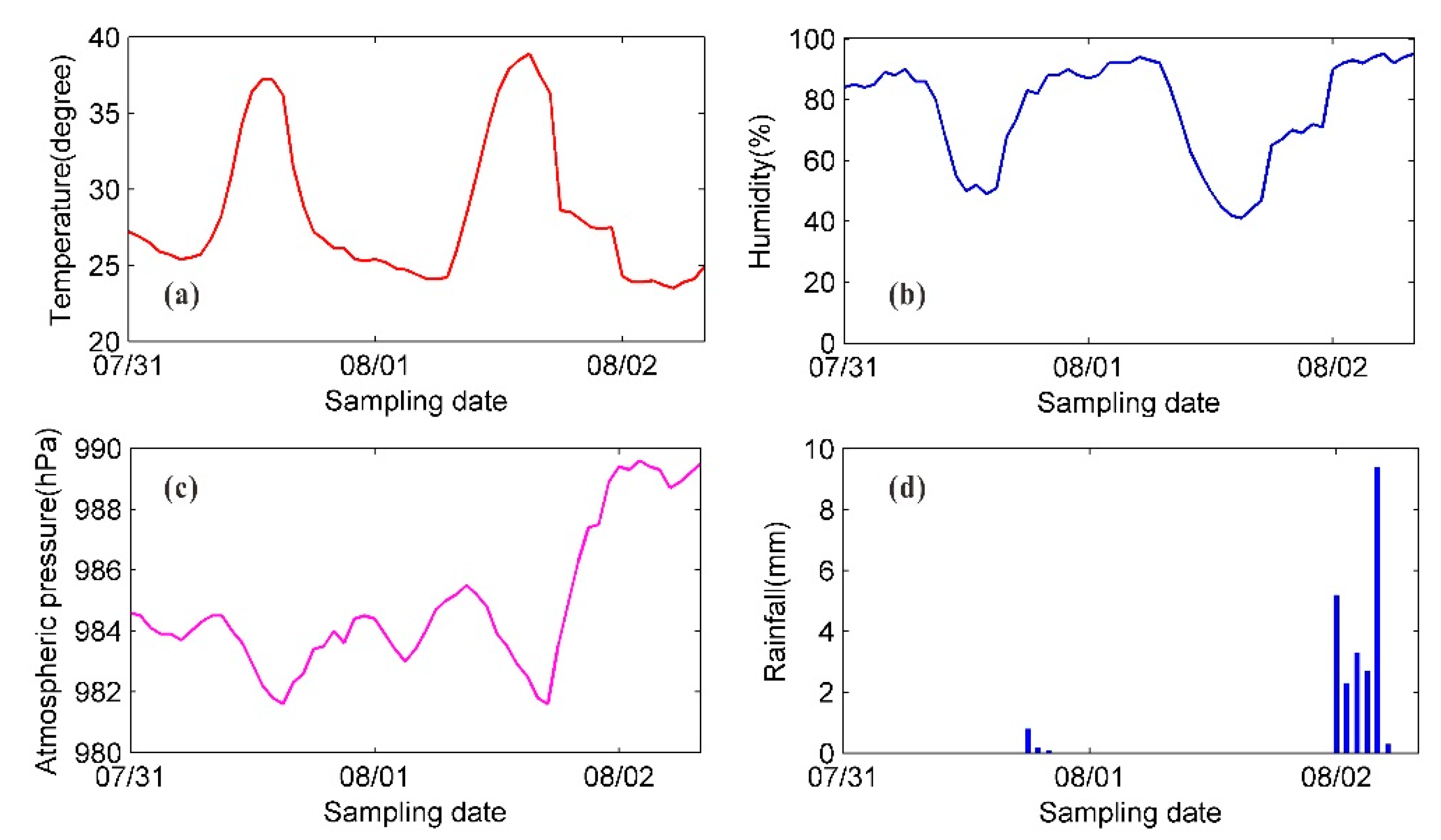
4.1. Experiment Overview
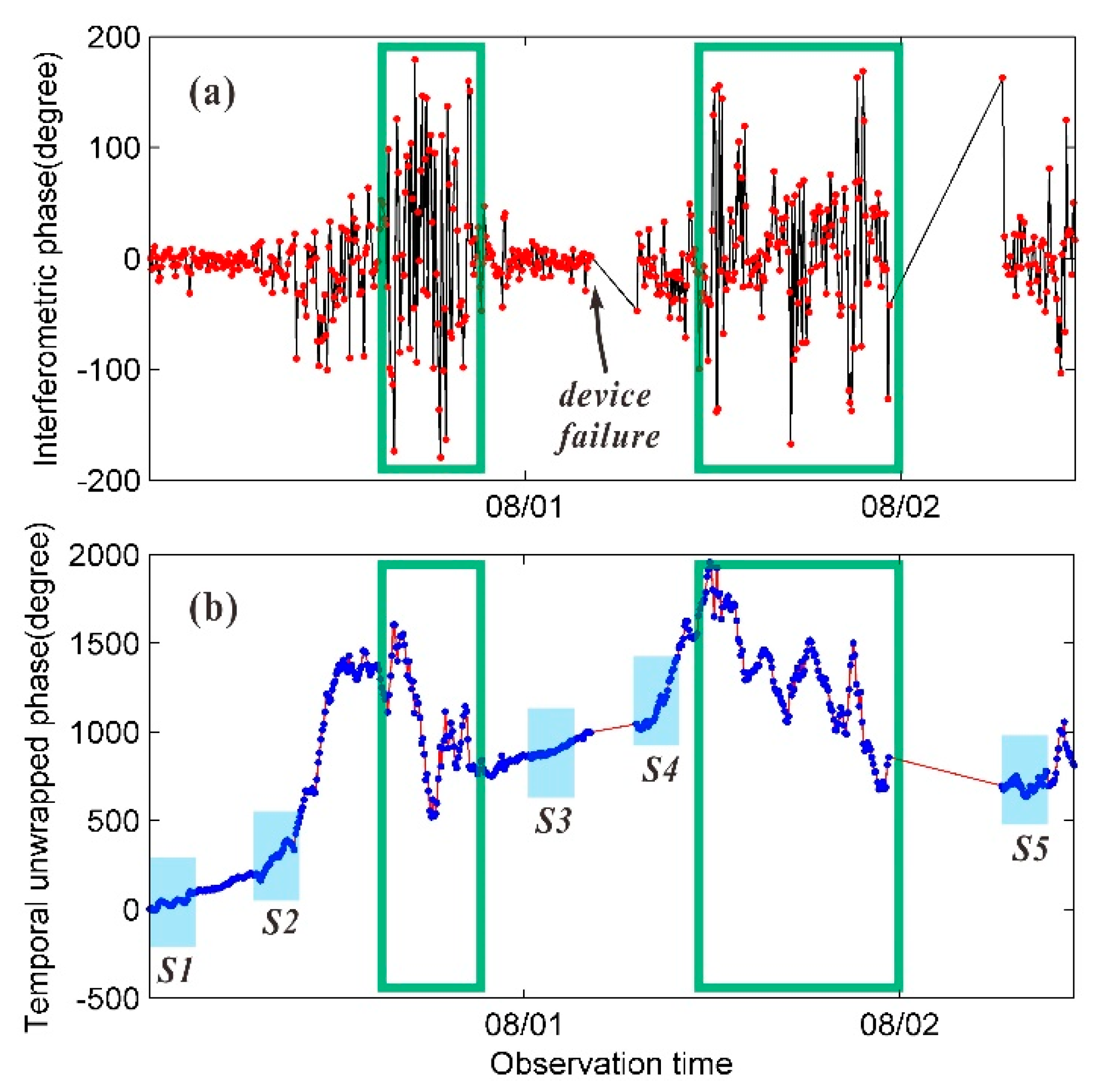
4.2. Image Subset Selection and Average Image Calculation
4.3. Deformation Extraction by Interferometric Calculation
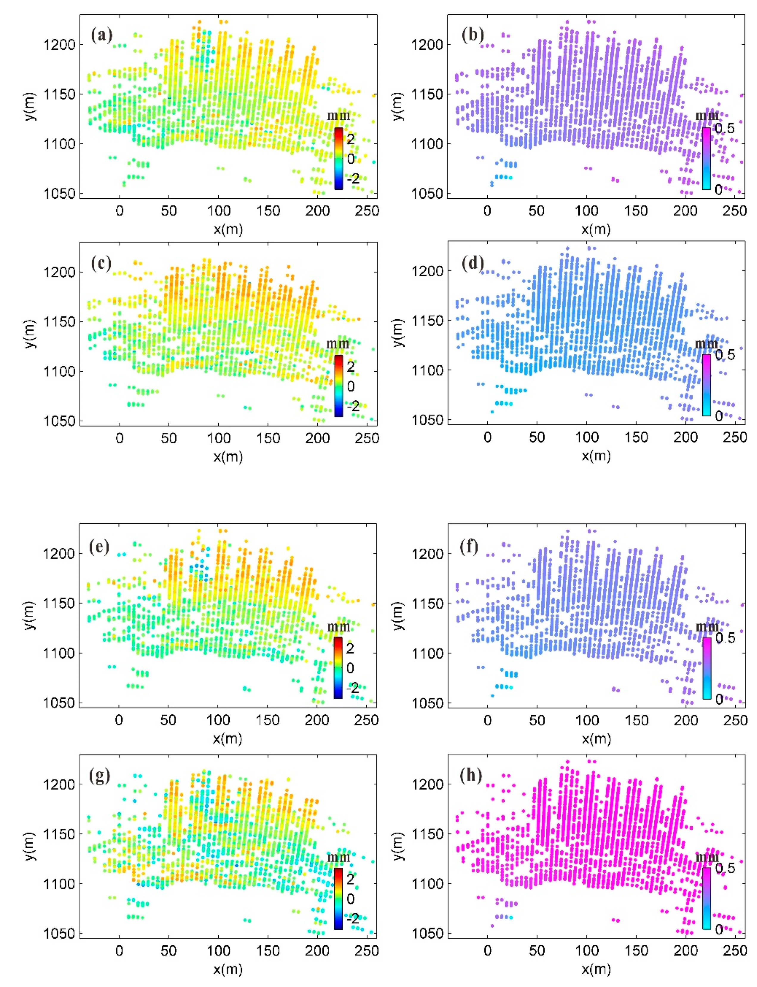
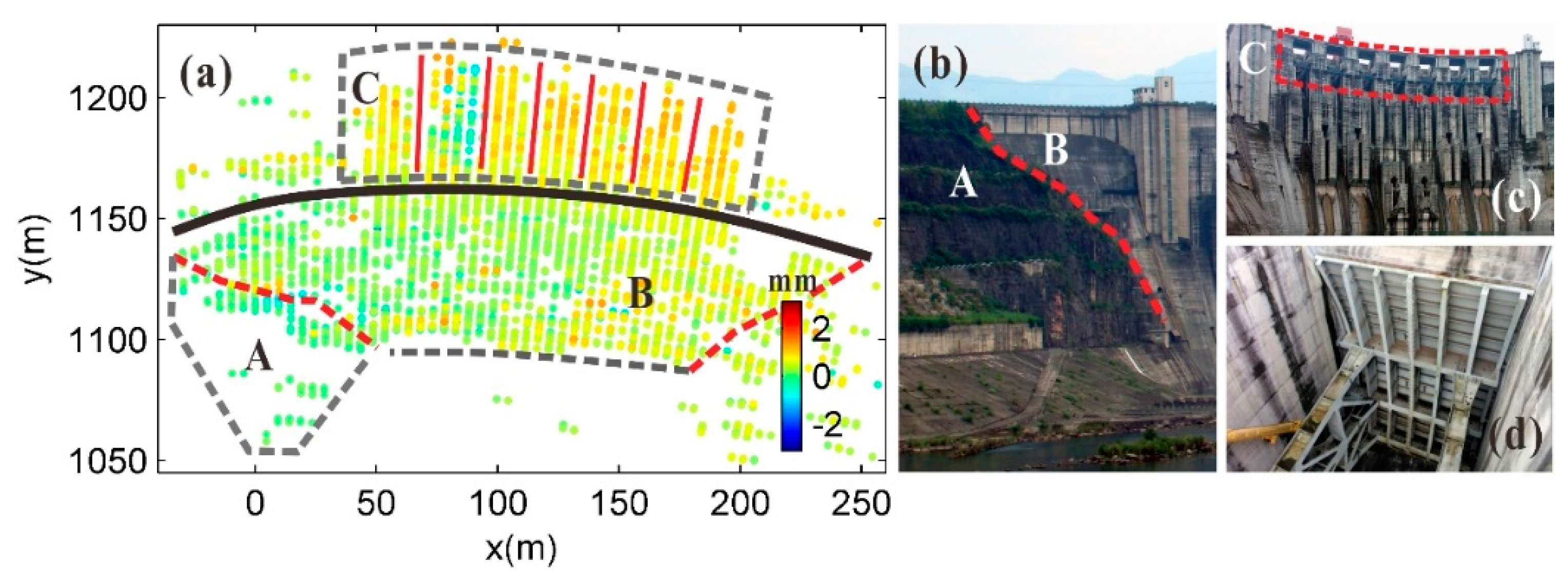
4.4. Analysis and Verification of Monitoring Results
5. Conclusions
Author Contributions
Funding
Conflicts of Interest
References
- Intrieri, E.; Di Traglia, F.; Del Ventisette, C.; Gigli, G.; Mugnai, F.; Luzi, G.; Casagli, N. Flank instability of Stromboli volcano (Aeolian Islands, Southern Italy): Integration of GB-InSAR and geomorphological observations. Geomorphology 2013, 201, 60–69. [Google Scholar] [CrossRef]
- Lowry, B.; Gomez, F.; Zhou, W.; Mooney, M.A.; Held, B.; Grasmick, J. High resolution displacement monitoring of a slow velocity landslide using ground based radar interferometry. Eng. Geol. 2013, 166, 160–169. [Google Scholar] [CrossRef]
- Gundersen, R.; Norland, R.; Rolstad Denby, C. Ground-based differential interferometric radar monitoring of unstable mountain blocks in a coastal environment. Remote Sens. 2018, 10, 914. [Google Scholar] [CrossRef]
- Carlà, T.; Farina, P.; Intrieri, E.; Ketizmen, H.; Casagli, N. Integration of ground-based radar and satellite InSAR data for the analysis of an unexpected slope failure in an open-pit mine. Eng. Geol. 2018, 235, 39–52. [Google Scholar] [CrossRef]
- Luzi, G.; Pieraccini, M.; Mecatti, D.; Noferini, L.; Macaluso, G.; Tamburini, A.; Atzeni, C. Monitoring of an alpine glacier by means of ground-based SAR interferometry. IEEE Geosci. Remote Sens. Lett. 2007, 4, 495–499. [Google Scholar] [CrossRef]
- Martinez-Vazquez, A.; Fortuny-Guasch, J. A GB-SAR processor for snow avalanche identification. IEEE Trans. Geosci. Remote Sens. 2008, 46, 3948–3956. [Google Scholar] [CrossRef]
- Monserrat, O.; Crosetto, M.; Luzi, G. A review of ground-based SAR interferometry for deformation measurement. ISPRS J. Photogramm. Remote Sens. 2014, 93, 40–48. [Google Scholar] [CrossRef]
- Carlà, T.; Nolesini, T.; Solari, L.; Rivolta, C.; Cas, L.D.; Casagli, N. Rockfall forecasting and risk management along a major transportation corridor in the Alps through ground-based radar interferometry. Landslides 2019, 16, 1425–1435. [Google Scholar] [CrossRef]
- Anghel, A.; Tudose, M.; Cacoveanu, R.; Datcu, M.; Nico, G.; Masci, O.; Dongyang, A.; Tian, W.; Hu, C.; Ding, Z.; et al. Compact Ground-Based Interferometric Synthetic Aperture Radar: Short-range structural monitoring. IEEE Signal Process. Mag. 2019, 36, 42–52. [Google Scholar] [CrossRef]
- Nico, G.; Cifarelli, G.; Miccoli, G.; Soccodato, F.; Feng, W.; Sato, M.; Miliziano, S.; Marini, M. Measurement of pier deformation patterns by ground-based SAR interferometry: Application to a bollard pull trial. IEEE J. Ocean. Eng. 2018, 43, 822–829. [Google Scholar] [CrossRef]
- Di Pasquale, A.; Nico, G.; Pitullo, A.; Prezioso, G. Monitoring strategies of earth dams by ground-based radar interferometry: How to extract useful information for seismic risk assessment. Sensors 2018, 18, 244. [Google Scholar] [CrossRef] [PubMed]
- Liu, X.; Lu, Z.; Yang, W.; Huang, M.; Tong, X. Dynamic monitoring and vibration analysis of ancient bridges by ground-based microwave interferometry and the ESMD method. Remote Sens. 2018, 10, 770. [Google Scholar] [CrossRef]
- Rödelsperger, S. Real-Time Processing of Ground Based Synthetic Aperture Radar (GB-SAR) Measurements; Technische Universität Darmstadt, Fachbereich Bauingenieurwesen und Geodäsie: Darmstadt, Germany, 2011. [Google Scholar]
- Wang, Z.; Li, Z.; Mills, J. Modelling of instrument repositioning errors in discontinuous Multi-Campaign Ground-Based SAR (MC-GBSAR) deformation monitoring. ISPRS J. Photogramm. Remote Sens. 2019, 157, 26–40. [Google Scholar] [CrossRef]
- Wang, Z.; Li, Z.; Liu, Y.; Peng, J.; Long, S.; Mills, J. A New Processing Chain for Real-Time Ground-Based SAR (RT-GBSAR) Deformation Monitoring. Remote Sens. 2019, 11, 2437. [Google Scholar] [CrossRef]
- Rödelsperger, S.; Läufer, G.; Gerstenecker, C.; Becker, M. Monitoring of displacements with ground-based microwave interferometry: IBIS-S and IBIS-L. J. Appl. Geod. 2010, 4, 41–54. [Google Scholar] [CrossRef]
- Liu, Y.; Lee, C.; Yong, H.; Jia, L.; Youshi, W.; Placidi, S.; Roedelsperger, S. FastGBSAR case studies in China: Monitoring of a dam and instable slope. In Proceedings of the 2015 IEEE 5th Asia-Pacific Conference on Synthetic Aperture Radar (APSAR), Singapore, 1–4 September 2015; pp. 849–852. [Google Scholar]
- Noferini, L.; Pieraccini, M.; Mecatti, D.; Macaluso, G.; Luzi, G.; Atzeni, C. Long term landslide monitoring by ground-based synthetic aperture radar interferometer. Int. J. Remote Sens. 2006, 27, 1893–1905. [Google Scholar] [CrossRef]
- Tarchi, D.; Casagli, N.; Fanti, R.; Leva, D.D.; Luzi, G.; Pasuto, A.; Pieraccini, M.; Silvano, S. Landslide monitoring by using ground-based SAR interferometry: An example of application to the Tessina landslide in Italy. Eng. Geol. 2003, 68, 15–30. [Google Scholar] [CrossRef]
- Noferini, L.; Pieraccini, M.; Mecatti, D.; Luzi, G.; Atzeni, C.; Tamburini, A.; Broccolato, M. Permanent scatterers analysis for atmospheric correction in ground-based SAR interferometry. IEEE Trans. Geosci. Remote Sens. 2005, 43, 1459–1471. [Google Scholar] [CrossRef]
- Gentile, C. Deflection measurement on vibrating stay cables by non-contact microwave interferometer. NDT E Int. 2010, 43, 231–240. [Google Scholar] [CrossRef]
- Berardino, P.; Fornaro, G.; Lanari, R.; Sansosti, E. A new algorithm for surface deformation monitoring based on small baseline differential SAR interferograms. IEEE Trans. Geosci. Remote Sens. 2002, 40, 2375–2383. [Google Scholar] [CrossRef]
- Wang, Z.; Li, Z.; Mills, J. A new approach to selecting coherent pixels for ground-based SAR deformation monitoring. ISPRS J. Photogramm. Remote Sens. 2018, 144, 412–422. [Google Scholar] [CrossRef]
- Ferretti, A.; Prati, C.; Rocca, F. Permanent Scatterers in SAR Interferometry. IEEE Trans. Geosci. Remote Sens. 2001, 39, 8–20. [Google Scholar] [CrossRef]
- Coppi, F.; Gentile, C.; Ricci, P. A software tool for processing the displacement time series extracted from raw radar data. AIP Conf. Proc. 2010, 1253, 190–201. [Google Scholar]
- Ferretti, A.; Prati, C.; Rocca, F. Nonlinear subsidence rate estimation using permanent scatterers in differential SAR interferometry. IEEE Trans. Geosci. Remote Sens. 2000, 38, 2202–2212. [Google Scholar] [CrossRef]
- Noferini, L.; Takayama, T.; Pieraccini, M.; Mecatti, D.; Macaluso, G.; Luzi, G.; Atzeni, C. Analysis of ground-based SAR data with diverse temporal baselines. IEEE Trans. Geosci. Remote Sens. 2008, 46, 1614–1623. [Google Scholar] [CrossRef]
- Wang, P.; Xing, C. Research on coordinate transformation method of GB-SAR image supported by 3D laser scanning technology. Int. Arch. Photogramm. Remote Sens. Spat. Inf. Sci. 2018, 42, 1757–1763. [Google Scholar] [CrossRef]


| Antenna Type | Gain | 20 dBi |
| Polarization mode | VV | |
| Signal Type | Frequency band and wavelength | Ku/1.78 cm |
| Bandwidth | 300 M (17.05–17.35 GHz) | |
| Synthetic Aperture Length | 2 m | |
| Resolution | Range | 5 m |
| Azimuth | 4.4 mrad | |
| Maximum Monitoring Distance Setting | 1300 m | |
| Average Image Acquisition Duration | 5.3833 min | |
| Image Subset No. | Starting Image No. | Acquisition Time M/D h:m | Last Image No. | Acquisition Time M/D h:m | Number of Images |
|---|---|---|---|---|---|
| S1 | 1 | 7/31 00:01 | 30 | 7/31 02:37 | 30 |
| S2 | 78 | 7/31 07:01 | 107 | 7/31 09:38 | 30 |
| S3 | 267 | 8/01 00:04 | 296 | 8/01 02:40 | 30 |
| S4 | 314 | 8/01 07:08 | 343 | 8/01 09:46 | 30 |
| S5 | 494 | 8/02 06:31 | 523 | 8/02 09:09 | 30 |
| Elevation/m | 85 | 105 | 122 | 145 | 169 | ||||||||||
|---|---|---|---|---|---|---|---|---|---|---|---|---|---|---|---|
| Time Interval | P | S | Δ | P | S | Δ | P | S | Δ | P | S | Δ | P | S | Δ |
| S1–S2 | 0.07 | 0.46 | 0.39 | 0.02 | 0.29 | 0.27 | −0.09 | 0.13 | 0.22 | 0.17 | 0.20 | 0.03 | −0.05 | 0.25 | 0.30 |
| S1–S3 | 0.07 | 0.01 | −0.06 | 0.05 | 0.18 | 0.13 | 0.10 | 0.16 | 0.06 | 0.41 | 0.21 | −0.20 | −0.02 | 0.24 | 0.26 |
| S1–S4 | 0.11 | −0.18 | −0.29 | 0.08 | 0.13 | 0.05 | 0.07 | −0.12 | −0.19 | 0.55 | 0.04 | −0.51 | 0.01 | 0.29 | 0.28 |
| S1–S5 | −0.01 | −0.27 | −0.26 | 0.05 | −0.11 | −0.16 | 0.10 | 0.12 | 0.02 | 0.65 | 0.11 | −0.54 | 0.11 | 0.18 | 0.07 |
| S4–S5 | −0.12 | −0.56 | −0.44 | −0.03 | −0.57 | −0.54 | 0.03 | −0.03 | −0.06 | 0.10 | 0.56 | −0.46 | 0.10 | 0.46 | −0.36 |
© 2020 by the authors. Licensee MDPI, Basel, Switzerland. This article is an open access article distributed under the terms and conditions of the Creative Commons Attribution (CC BY) license (http://creativecommons.org/licenses/by/4.0/).
Share and Cite
Wang, P.; Xing, C.; Pan, X. Reservoir Dam Surface Deformation Monitoring by Differential GB-InSAR Based on Image Subsets. Sensors 2020, 20, 396. https://doi.org/10.3390/s20020396
Wang P, Xing C, Pan X. Reservoir Dam Surface Deformation Monitoring by Differential GB-InSAR Based on Image Subsets. Sensors. 2020; 20(2):396. https://doi.org/10.3390/s20020396
Chicago/Turabian StyleWang, Peng, Cheng Xing, and Xiandong Pan. 2020. "Reservoir Dam Surface Deformation Monitoring by Differential GB-InSAR Based on Image Subsets" Sensors 20, no. 2: 396. https://doi.org/10.3390/s20020396
APA StyleWang, P., Xing, C., & Pan, X. (2020). Reservoir Dam Surface Deformation Monitoring by Differential GB-InSAR Based on Image Subsets. Sensors, 20(2), 396. https://doi.org/10.3390/s20020396