Novel GIS Based Machine Learning Algorithms for Shallow Landslide Susceptibility Mapping

 , ,
, ,  ,
,  ,
,  , ,
, ,  ,
,
Abstract
1. Introduction
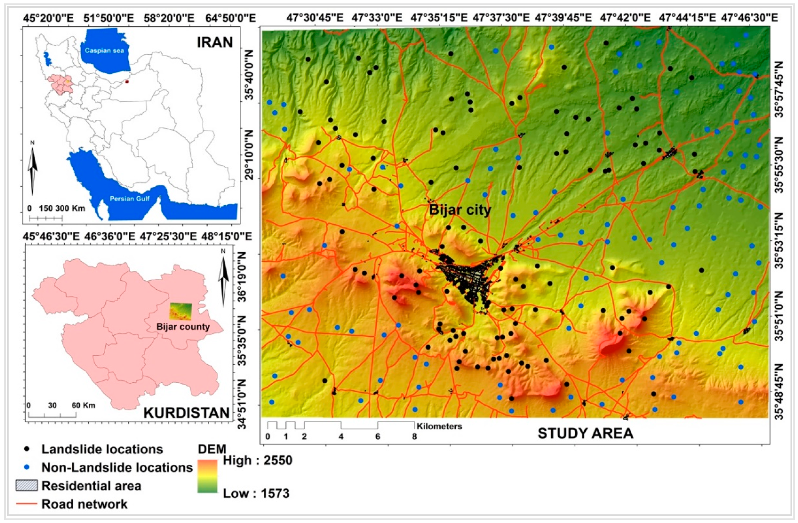
2. Description of Study Area
3. Data Acquisition and Processing
3.1. Landslide Inventory Map
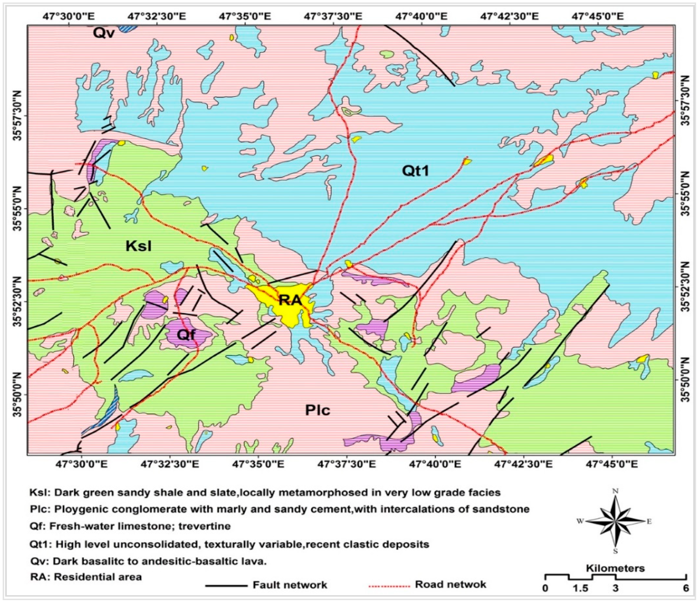
3.2. Landslide Conditioning Factors
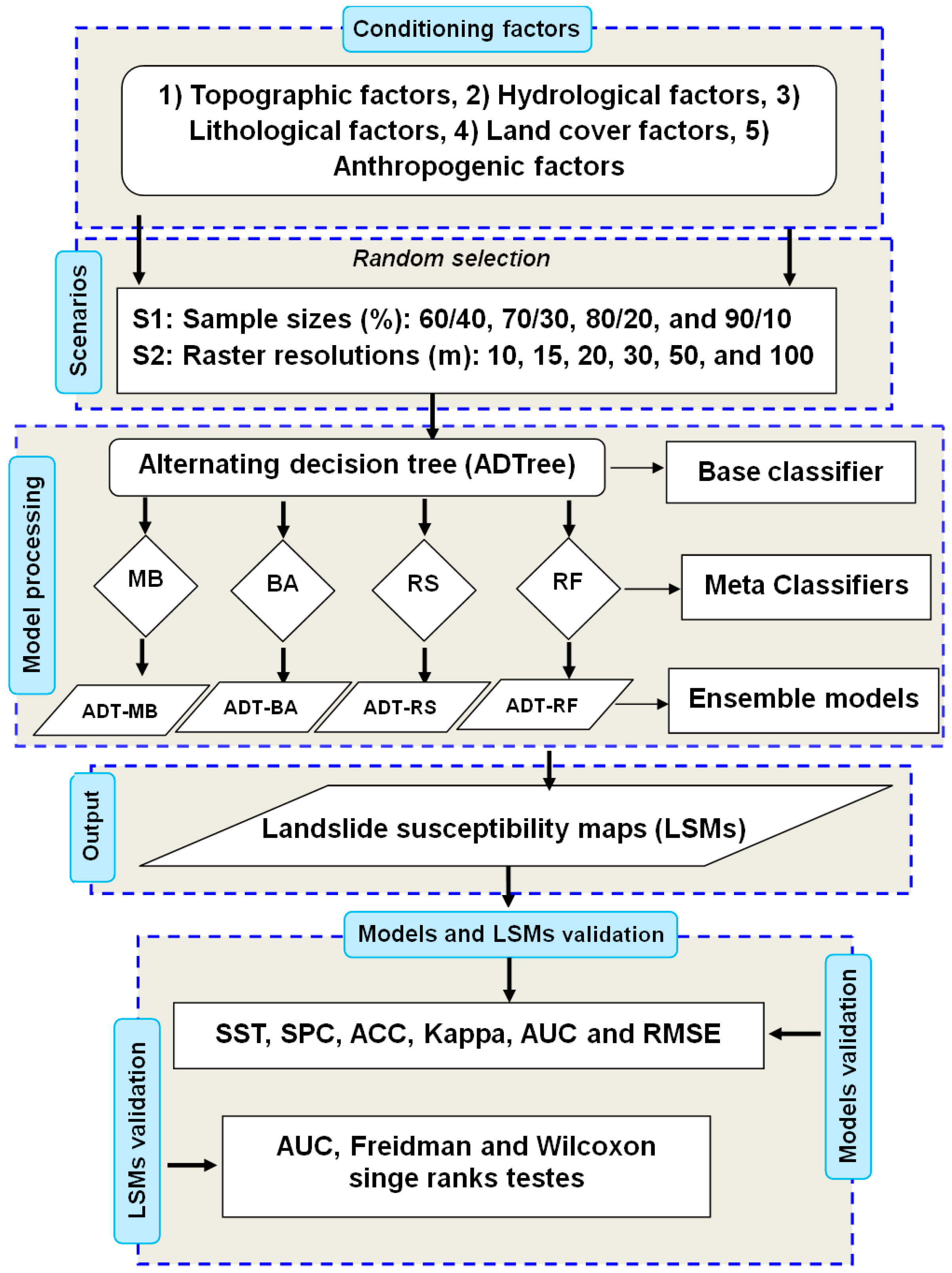
4. Methodology
4.1. Alternating Decision Tree (ADTree)
4.2. Bagging (BA)
4.3. Multiboost (MB)
4.4. Random Subspace (RS)
4.5. Rotation Forest (RF)
4.6. Comparison and Validation Techniques
4.6.1. Statistical Index-Based Measures
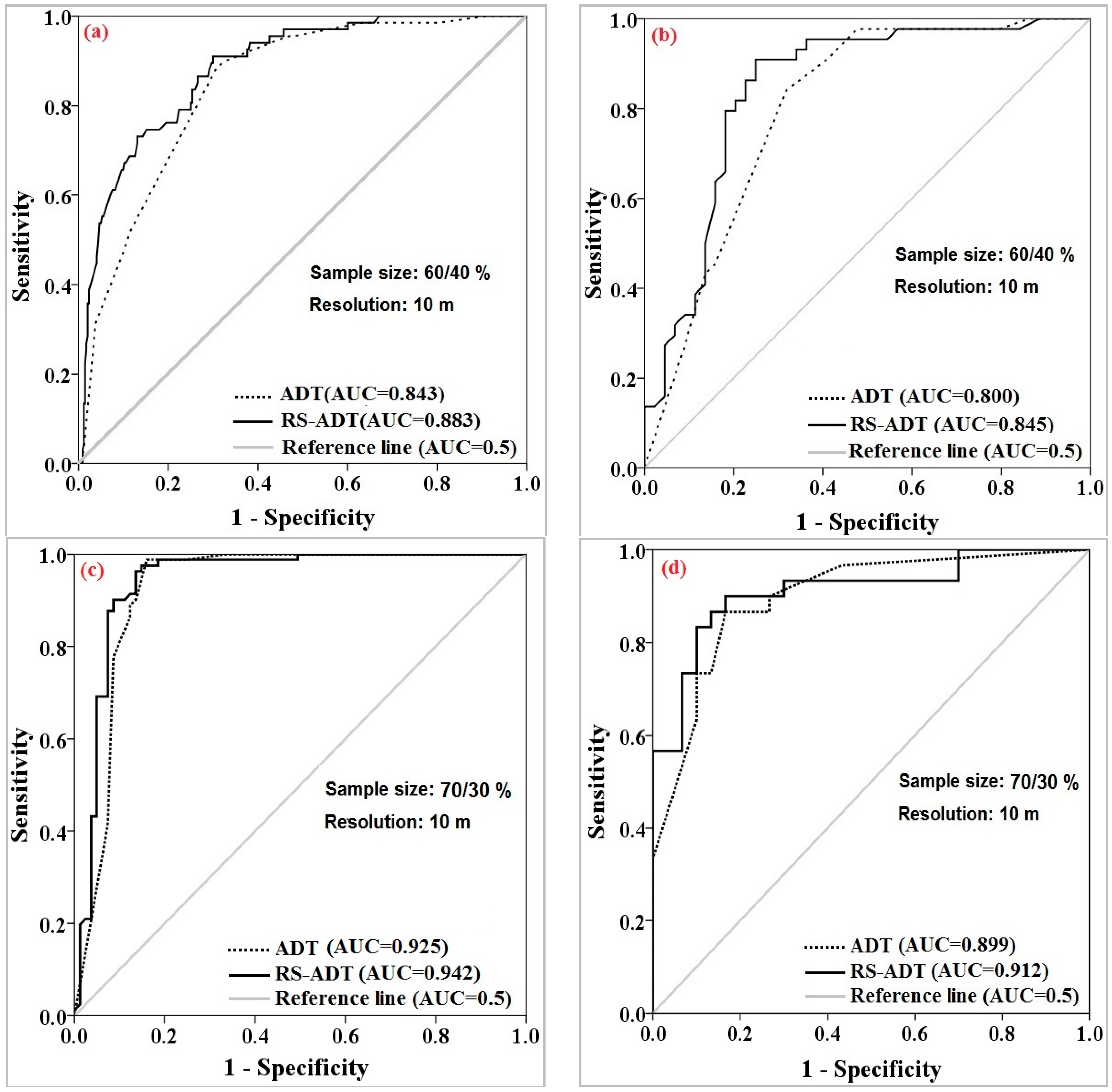
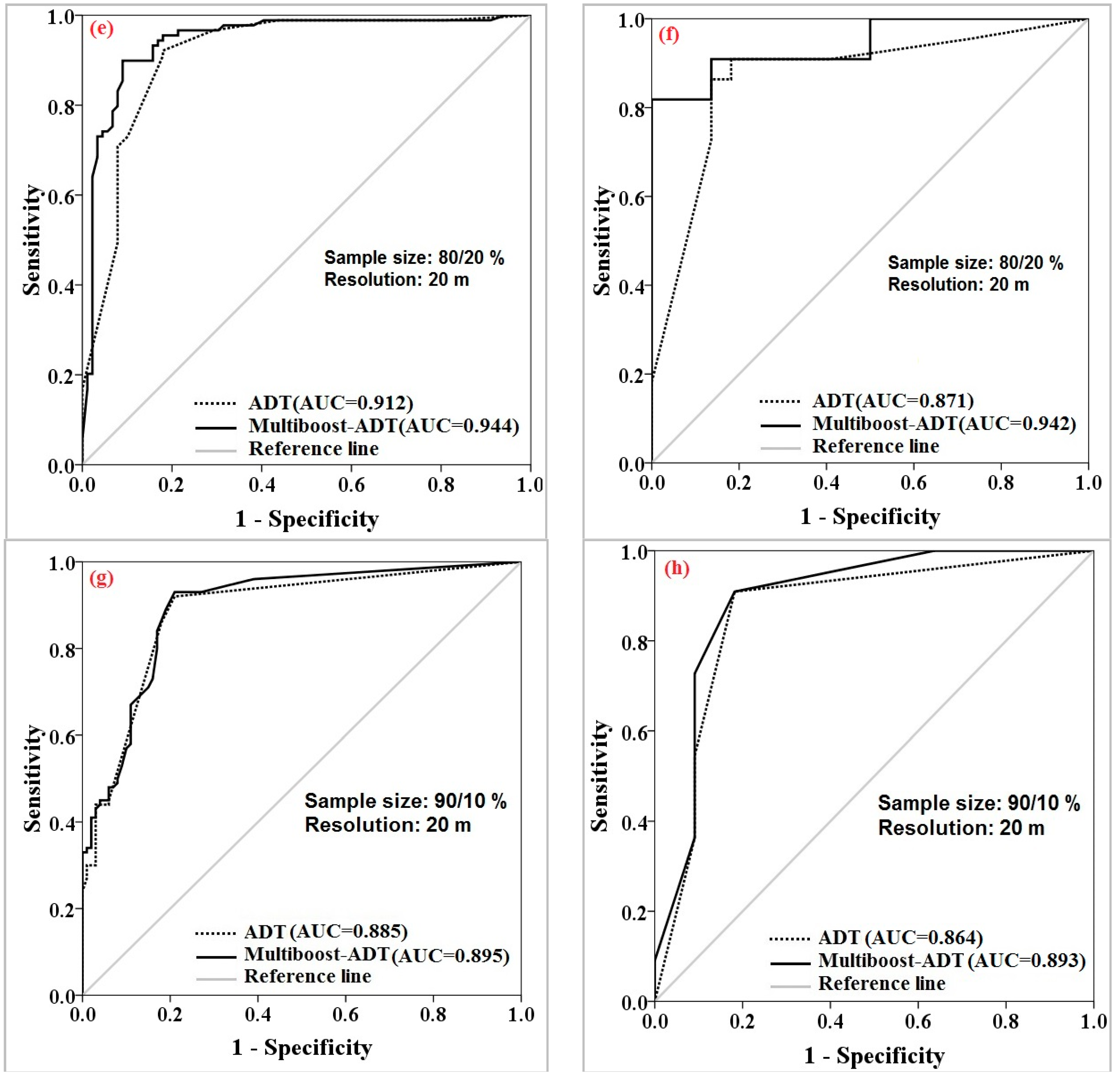
4.6.2. Receiver Operating Characteristic Curve
4.6.3. Parametric and Non-Parametric Statistical Tests
4.7. Factor Selecting based on the Information Gain Ration (IGR) Technique
5. Result and Analysis
5.1. Important Factors for Landslide Modeling
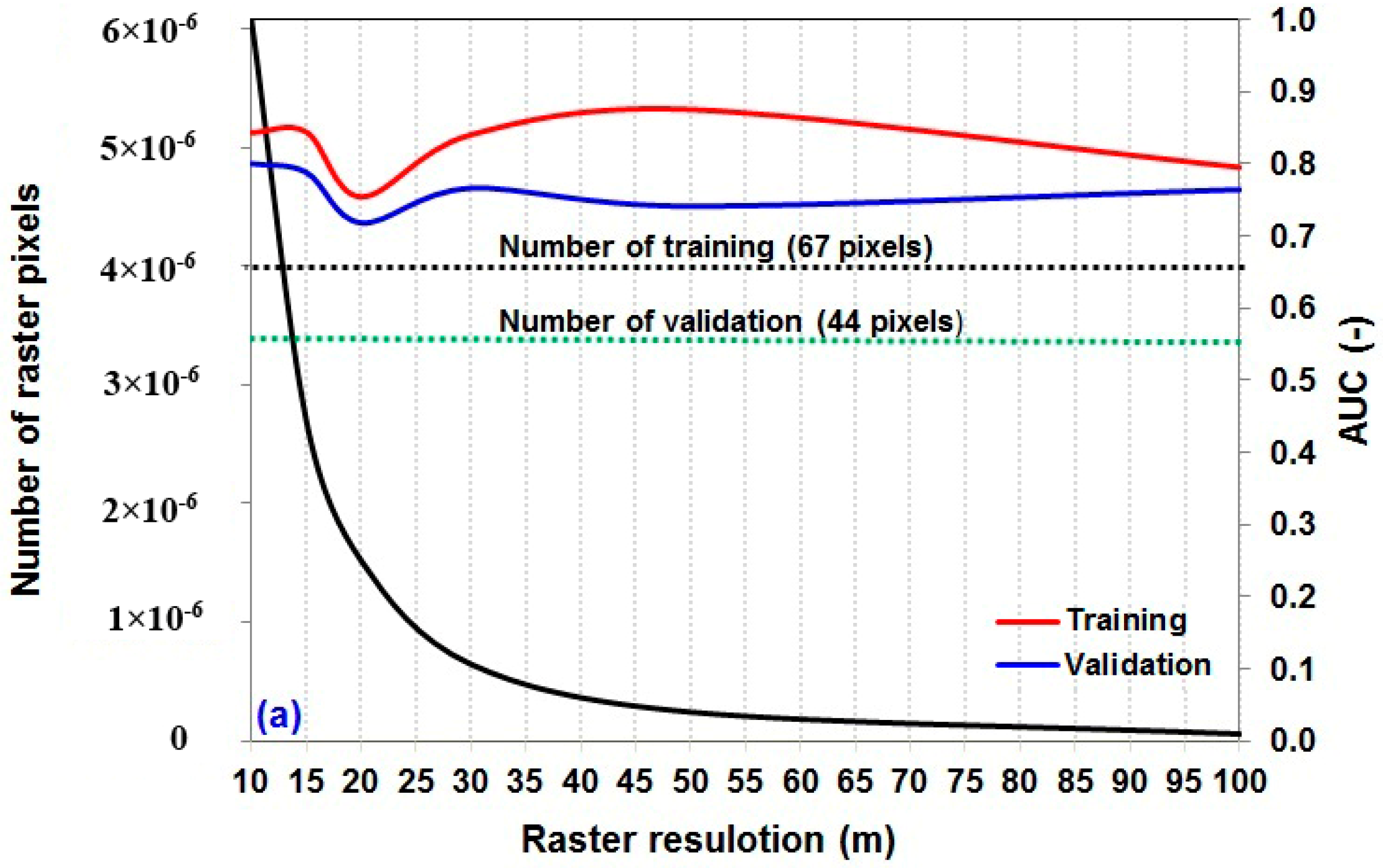
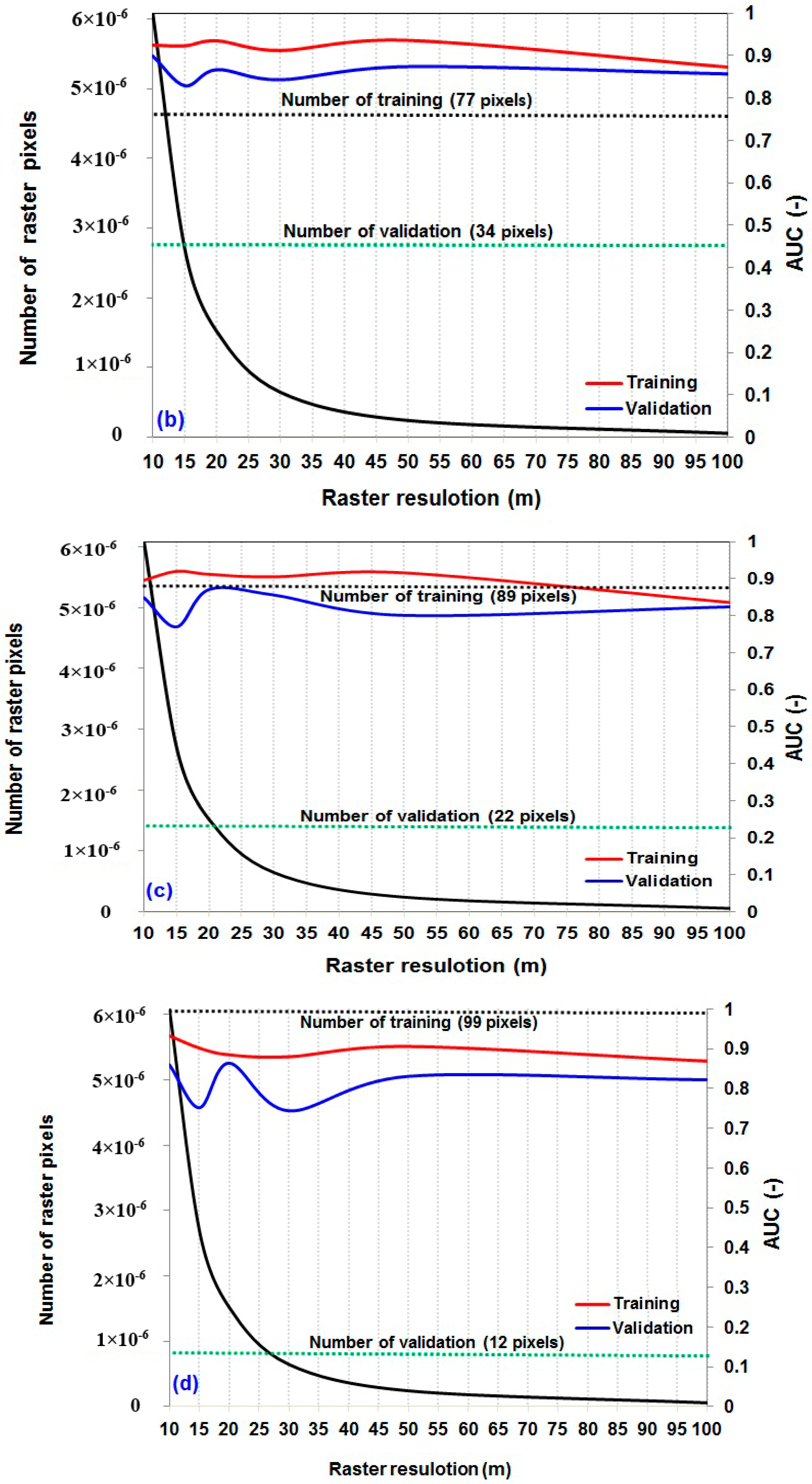
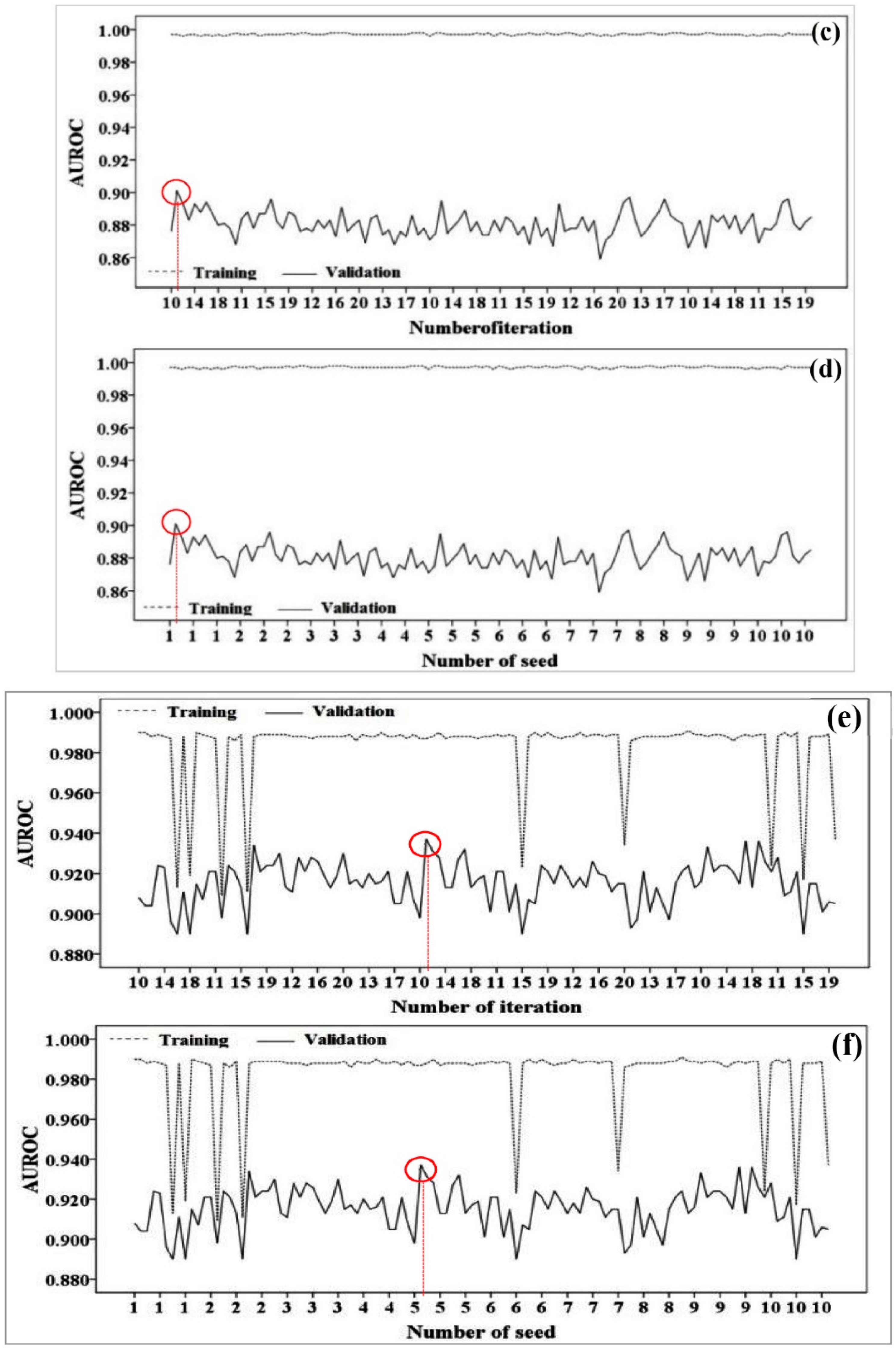
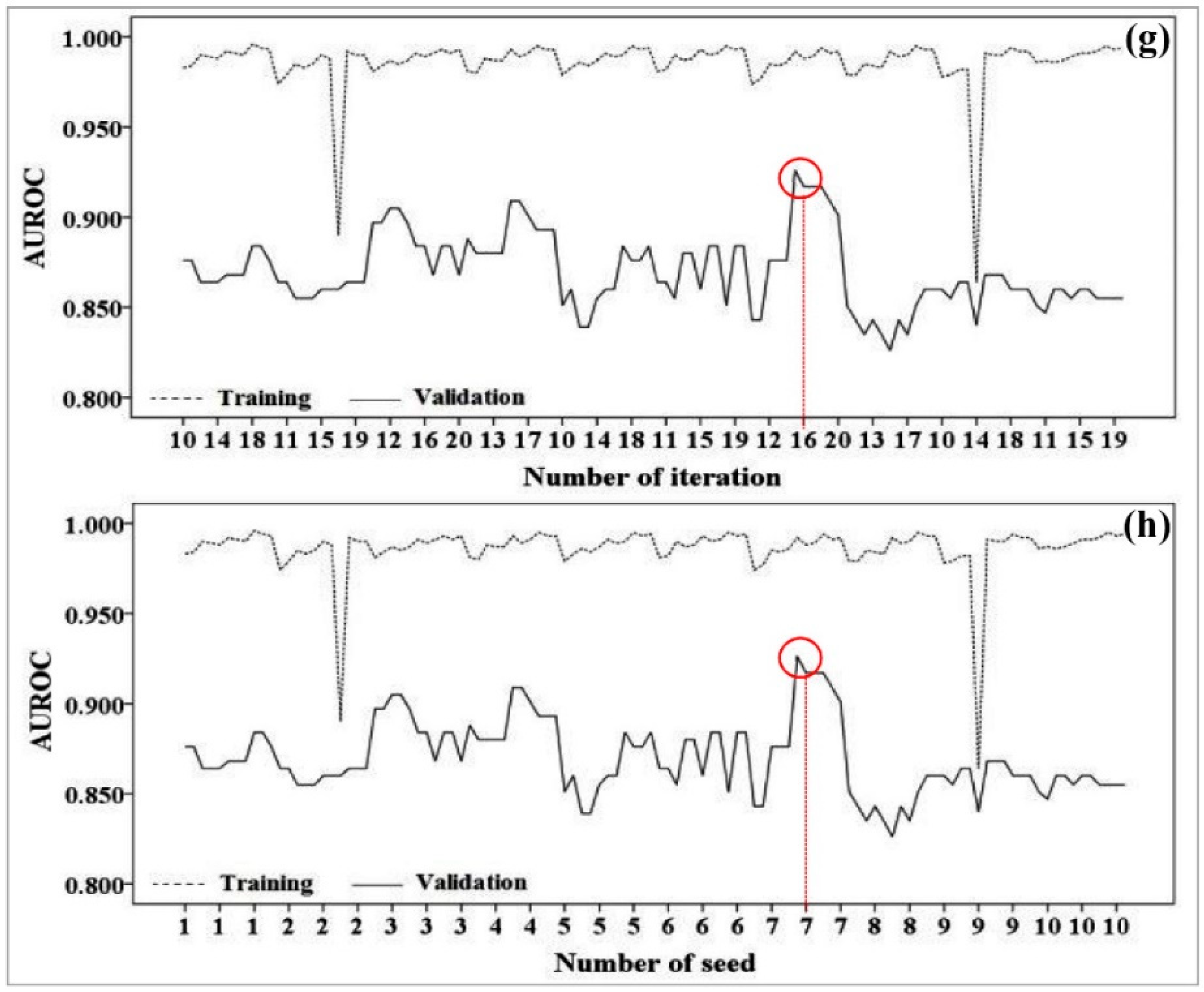
5.2. Selecting the Best Raster Resolution for Each Combination
5.3. Landslide Modeling Process
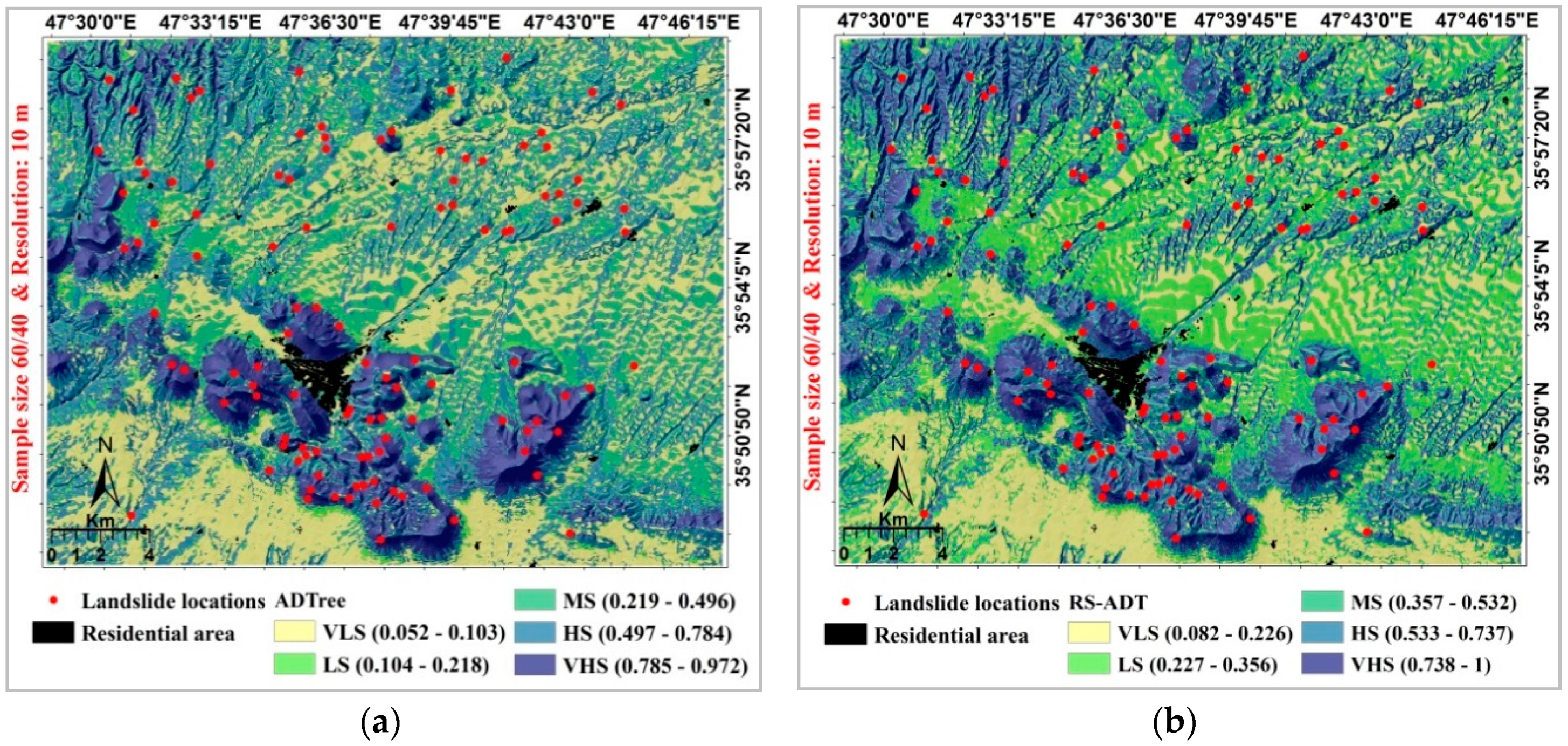
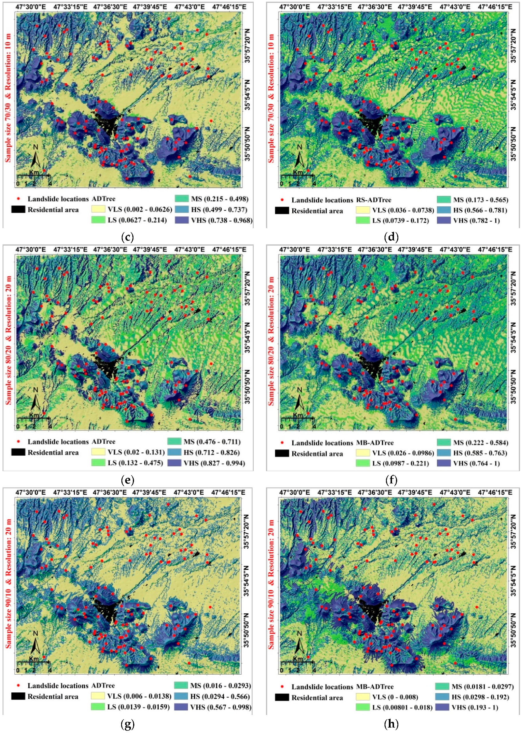
5.4. Landslide Susceptibility Mapping
5.5. Evaluation of Landslide Susceptibility Maps
6. Discussion
7. Conclusions
Author Contributions
Funding
Acknowledgments
Conflicts of Interest
References
- Kutlug Sahin, E.; Ipbuker, C.; Kavzoglu, T. Investigation of automatic feature weighting methods (Fisher, Chi-square and Relief-F) for landslide susceptibility mapping. Geocarto Int. 2017, 32, 956–977. [Google Scholar] [CrossRef]
- Chapi, K.; Rudra, R.P.; Ahmed, S.I.; Khan, A.A.; Gharabaghi, B.; Dickinson, W.T.; Goel, P.K. Spatial-temporal dynamics of runoff generation areas in a small agricultural watershed in Southern Ontario. J. Water Resour. Prot. 2015, 7, 14–40. [Google Scholar] [CrossRef]
- Wang, L.-J.; Guo, M.; Sawada, K.; Lin, J.; Zhang, J. A comparative study of landslide susceptibility maps using logistic regression, frequency ratio, decision tree, weights of evidence and artificial neural network. Geosci. J. 2016, 20, 117–136. [Google Scholar] [CrossRef]
- Pradhan, B.; Seeni, M.I.; Kalantar, B. Performance evaluation and sensitivity analysis of expert-based, statistical, machine learning, and hybrid models for producing landslide susceptibility maps. In Laser Scanning Applications in Landslide Assessment; Springer: Berlin, Germany, 2017; pp. 193–232. [Google Scholar]
- Borrelli, L.; Ciurleo, M.; Gullà, G. Shallow landslide susceptibility assessment in granitic rocks using gis-based statistical methods: The contribution of the weathering grade map. Landslides 2018, 15, 1127–1142. [Google Scholar] [CrossRef]
- Ciurleo, M.; Cascini, L.; Calvello, M. A comparison of statistical and deterministic methods for shallow landslide susceptibility zoning in clayey soils. Eng. Geol. 2017, 223, 71–81. [Google Scholar] [CrossRef]
- Cascini, L.; Ciurleo, M.; Di Nocera, S.; Gullà, G. A new–old approach for shallow landslide analysis and susceptibility zoning in fine-grained weathered soils of Southern Italy. Geomorphology 2015, 241, 371–381. [Google Scholar] [CrossRef]
- Crosta, G.; Imposimato, S.; Roddeman, D. Numerical modelling of large landslides stability and runout. Nat. Hazards Earth Syst. Sci. 2003, 3, 523–538. [Google Scholar] [CrossRef]
- Di, B.; Stamatopoulos, C.A.; Dandoulaki, M.; Stavrogiannopoulou, E.; Zhang, M.; Bampina, P. A method predicting the earthquake-induced landslide risk by back analyses of past landslides and its application in the region of the Wenchuan 12/5/2008 earthquake. Nat. Hazards 2017, 85, 903–927. [Google Scholar] [CrossRef]
- Fathani, T. The analysis of earthquake-induced landslides with a three-dimensional numerical model. In Proceedings of the Geotechnics Symposium, Yogyakarta, Indonesia, 28 August 2006; pp. 159–165. [Google Scholar]
- McDougall, S.; Hungr, O. A model for the analysis of rapid landslide motion across three-dimensional terrain. Can. Geotech. J. 2004, 41, 1084–1097. [Google Scholar] [CrossRef]
- Pastor, M.; Haddad, B.; Sorbino, G.; Cuomo, S.; Drempetic, V. A depth-integrated, coupled SPH model for flow-like landslides and related phenomena. Int. J. Numer. Anal. Methods Geomech. 2009, 33, 143–172. [Google Scholar] [CrossRef]
- Stamatopoulos, C.A.; Di, B. Analytical and approximate expressions predicting post-failure landslide displacement using the multi-block model and energy methods. Landslides 2015, 12, 1207–1213. [Google Scholar] [CrossRef]
- Ada, M.; San, B.T. Comparison of machine-learning techniques for landslide susceptibility mapping using two-level random sampling (2LRS) in Alakir Catchment area, Antalya, Turkey. Nat. Hazards 2018, 90, 237–263. [Google Scholar] [CrossRef]
- Pham, B.T.; Pradhan, B.; Bui, D.T.; Prakash, I.; Dholakia, M. A comparative study of different machine learning methods for landslide susceptibility assessment: A case study of Uttarakhand area (India). Environ. Model. Softw. 2016, 84, 240–250. [Google Scholar] [CrossRef]
- Goetz, J.; Brenning, A.; Petschko, H.; Leopold, P. Evaluating machine learning and statistical prediction techniques for landslide susceptibility modeling. Comput. Geosci. 2015, 81, 1–11. [Google Scholar] [CrossRef]
- Pham, B.T.; Bui, D.T.; Prakash, I.; Dholakia, M. Rotation forest fuzzy rule-based classifier ensemble for spatial prediction of landslides using GIS. Nat. Hazards 2016, 83, 97–127. [Google Scholar] [CrossRef]
- Pham, B.T.; Prakash, I.; Bui, D.T. Spatial prediction of landslides using a hybrid machine learning approach based on random subspace and classification and regression trees. Geomorphology 2018, 303, 256–270. [Google Scholar] [CrossRef]
- Hong, H.; Liu, J.; Bui, D.T.; Pradhan, B.; Acharya, T.D.; Pham, B.T.; Zhu, A.-X.; Chen, W.; Ahmad, B.B. Landslide susceptibility mapping using j48 decision tree with adaboost, bagging and rotation forest ensembles in the Guangchang area (China). Catena 2018, 163, 399–413. [Google Scholar] [CrossRef]
- Pham, B.T.; Jaafari, A.; Prakash, I.; Bui, D.T. A novel hybrid intelligent model of support vector machines and the multiboost ensemble for landslide susceptibility modeling. Bull. Eng. Geol. Environ. 2018, 1–22. [Google Scholar] [CrossRef]
- Pham, B.T.; Bui, D.T.; Prakash, I. Bagging based support vector machines for spatial prediction of landslides. Environ. Earth Sci. 2018, 77, 146. [Google Scholar] [CrossRef]
- Shirzadi, A.; Chapi, K.; Shahabi, H.; Solaimani, K.; Kavian, A.; Ahmad, B.B. Rock fall susceptibility assessment along a mountainous road: An evaluation of bivariate statistic, analytical hierarchy process and frequency ratio. Environ. Earth Sci. 2017, 76, 152. [Google Scholar] [CrossRef]
- Galli, M.; Ardizzone, F.; Cardinali, M.; Guzzetti, F.; Reichenbach, P. Comparing landslide inventory maps. Geomorphology 2008, 94, 268–289. [Google Scholar] [CrossRef]
- Borrelli, L.; Cofone, G.; Coscarelli, R.; Gullà, G. Shallow landslides triggered by consecutive rainfall events at catanzaro strait (Calabria–Southern Italy). J. Maps 2015, 11, 730–744. [Google Scholar] [CrossRef]
- Chen, W.; Xie, X.; Wang, J.; Pradhan, B.; Hong, H.; Bui, D.T.; Duan, Z.; Ma, J. A comparative study of logistic model tree, random forest, and classification and regression tree models for spatial prediction of landslide susceptibility. Catena 2017, 151, 147–160. [Google Scholar] [CrossRef]
- Huggel, C.; Schneider, D.; Miranda, P.J.; Granados, H.D.; Kääb, A. Evaluation of aster and srtm dem data for lahar modeling: A case study on lahars from Popocatépetl Volcano, Mexico. J. Volcanol. Geotherm. Res. 2008, 170, 99–110. [Google Scholar] [CrossRef]
- Hosseinzadeh, S.R. Drainage network analysis, comparis of digital elevation model (DEM) from aster with high resolution satellite image and areal photographs. Int. J. Environ. Sci. Dev. 2011, 2, 194–198. [Google Scholar] [CrossRef]
- Althuwaynee, O.F.; Pradhan, B.; Lee, S. A novel integrated model for assessing landslide susceptibility mapping using chaid and ahp pair-wise comparison. Int. J. Remote Sens. 2016, 37, 1190–1209. [Google Scholar] [CrossRef]
- Chen, W.; Shahabi, H.; Shirzadi, A.; Li, T.; Guo, C.; Hong, H.; Li, W.; Pan, D.; Hui, J.; Ma, M. A novel ensemble approach of bivariate statistical-based logistic model tree classifier for landslide susceptibility assessment. Geocarto Int. 2018, 1–23. [Google Scholar] [CrossRef]
- Pham, B.T.; Shirzadi, A.; Bui, D.T.; Prakash, I.; Dholakia, M. A hybrid machine learning ensemble approach based on a radial basis function neural network and rotation forest for landslide susceptibility modeling: A case study in the Himalayan area, India. Int. J. Sediment Res. 2018, 33, 157–170. [Google Scholar] [CrossRef]
- Calvello, M.; Ciurleo, M. Optimal use of thematic maps for landslide susceptibility assessment by means of statistical analyses: Case study of shallow landslides in fine grained soils. In Landslides and Engineered Slopes. Experience, Theory and Practice; CRC Press: Boca Raton, FL, USA, 2016. [Google Scholar]
- Yilmaz, C.; Topal, T.; Süzen, M.L. Gis-based landslide susceptibility mapping using bivariate statistical analysis in Devrek (Zonguldak-Turkey). Environ. Earth Sci. 2012, 65, 2161–2178. [Google Scholar] [CrossRef]
- Pradhan, A.M.S.; Kim, Y.-T. Relative effect method of landslide susceptibility zonation in weathered granite soil: A case study in Deokjeok-ri Creek, South Korea. Nat. Hazards 2014, 72, 1189–1217. [Google Scholar] [CrossRef]
- Brown, M.K. Landslide Detection and Susceptibility Mapping Using Lidar and Artificial Neural Network Modeling: A Case Study in Glacially Dominated Cuyahoga River Valley, Ohio; Bowling Green State University: Bowling Green, OH, USA, 2012. [Google Scholar]
- Poudyal, C.P.; Chang, C.; Oh, H.-J.; Lee, S. Landslide susceptibility maps comparing frequency ratio and artificial neural networks: A case study from the Nepal Himalaya. Environ. Earth Sci. 2010, 61, 1049–1064. [Google Scholar] [CrossRef]
- Dehnavi, A.; Aghdam, I.N.; Pradhan, B.; Varzandeh, M.H.M. A new hybrid model using step-wise weight assessment ratio analysis (SWARA) technique and adaptive neuro-fuzzy inference system (ANFIS) for regional landslide hazard assessment in Iran. Catena 2015, 135, 122–148. [Google Scholar] [CrossRef]
- Chapi, K.; Singh, V.P.; Shirzadi, A.; Shahabi, H.; Bui, D.T.; Pham, B.T.; Khosravi, K. A novel hybrid artificial intelligence approach for flood susceptibility assessment. Environ. Model. Softw. 2017, 95, 229–245. [Google Scholar] [CrossRef]
- Freund, Y.; Mason, L. The Alternating decision tree learning algorithm. In Proceedings of the Sixteenth International Conference on Machine Learning (ICML’99), Bled, Slovenia, 27–30 June 1999; pp. 124–133. [Google Scholar]
- Hong, H.; Pradhan, B.; Xu, C.; Bui, D.T. Spatial prediction of landslide hazard at the Yihuang area (China) using two-class kernel logistic regression, alternating decision tree and support vector machines. Catena 2015, 133, 266–281. [Google Scholar] [CrossRef]
- Chen, W.; Zhang, S.; Li, R.; Shahabi, H. Performance evaluation of the gis-based data mining techniques of best-first decision tree, random forest, and naïve bayes tree for landslide susceptibility modeling. Sci. Total Environ. 2018, 644, 1006–1018. [Google Scholar] [CrossRef]
- Liu, K.-Y.; Lin, J.; Zhou, X.; Wong, S.T. Boosting alternating decision trees modeling of disease trait information. BMC Genet. 2005, 6, S132. [Google Scholar] [CrossRef] [PubMed]
- Zhu, J.J.; Zhang, X.J.; Gu, J.H.; Zhao, H.M.; Zhou, Q.; Tao, Z. Research on recognition of pathological voice by AD tree. Adv. Mater. Res. 2013, 658, 647–651. [Google Scholar] [CrossRef]
- Pfahringer, B.; Holmes, G.; Kirkby, R. Optimizing the induction of alternating decision trees. In Proceedings of the 5th Pacific-Asia Conference on Knowledge Discovery and Data Mining (PAKDD 2001), Hong Kong, China, 16–18 April 2001; Springer: Hong Kong, China, 2001; pp. 477–487. [Google Scholar]
- Breiman, L. Bagging predictors. Mach. Learn. 1996, 24, 123–140. [Google Scholar] [CrossRef]
- Opitz, D.; Maclin, R. Popular ensemble methods: An empirical study. J. Artif. Intell. Res. 1999, 11, 169–198. [Google Scholar] [CrossRef]
- Bauer, E.; Kohavi, R. An empirical comparison of voting classification algorithms: Bagging, boosting, and variants. Mach. Learn. 1999, 36, 105–139. [Google Scholar] [CrossRef]
- Breiman, L. Random forests. Mach. Learn. 2001, 45, 5–32. [Google Scholar] [CrossRef]
- Pham, B.T.; Bui, D.T.; Prakash, I. Landslide susceptibility assessment using bagging ensemble based alternating decision trees, logistic regression and j48 decision trees methods: A comparative study. Geotech. Geol. Eng. 2017, 35, 2597–2611. [Google Scholar] [CrossRef]
- Bui, D.T.; Ho, T.-C.; Pradhan, B.; Pham, B.-T.; Nhu, V.-H.; Revhaug, I. Gis-based modeling of rainfall-induced landslides using data mining-based functional trees classifier with adaboost, bagging, and multiboost ensemble frameworks. Environ. Earth Sci. 2016, 75, 1101. [Google Scholar]
- Bui, D.T.; Ho, T.C.; Revhaug, I.; Pradhan, B.; Nguyen, D.B. Landslide susceptibility mapping along the national road 32 of vietnam using gis-based j48 decision tree classifier and its ensembles. In Cartography from Pole to Pole; Springer: Berlin, Germany, 2014; pp. 303–317. [Google Scholar]
- Webb, G.I. Multiboosting: A technique for combining boosting and wagging. Mach. Learn. 2000, 40, 159–196. [Google Scholar] [CrossRef]
- Wang, C.-W.; Hunter, A. A low variance error boosting algorithm. Appl. Intell. 2010, 33, 357–369. [Google Scholar] [CrossRef]
- Xia, C.-K.; Su, C.-L.; Cao, J.-T.; Li, P. Multiboost with enn-based ensemble fault diagnosis method and its application in complicated chemical process. J. Cent. South Univ. 2016, 23, 1183–1197. [Google Scholar] [CrossRef]
- Ho, T.K. Random subspace method for constructing decision forests. IEEE Trans. Pattern Anal. Mach. Intell. 1998, 20, 832–844. [Google Scholar]
- Wang, G.; Sun, J.; Ma, J.; Xu, K.; Gu, J. Sentiment classification: The contribution of ensemble learning. Decis. Support Syst. 2014, 57, 77–93. [Google Scholar] [CrossRef]
- Sun, S. An improved random subspace method and its application to eeg signal classification. In Proceedings of the 7th International Workshop, Prague, Czech Republic, 23–25 May 2007; pp. 103–112. [Google Scholar]
- Liu, L.; Zhang, H.; Hu, X.; Sun, F. Semi-supervised image classification learning based on random feature subspace. In Proceedings of the Pattern Recognition: 6th Chinese Conference, Changsha, China, 17–19 November 2014; pp. 237–242. [Google Scholar]
- Zhu, M.; Li, A. Random subspace method for improving performance of credit cardholder classification. In Modeling Risk Management for Resources and Environment in China; Wu, D.D., Zhou, Y., Eds.; Springer: Berlin, Germany, 2011; pp. 257–264. [Google Scholar]
- Rodriguez, J.J.; Kuncheva, L.I.; Alonso, C.J. Rotation forest: A new classifier ensemble method. IEEE Trans. Pattern Anal. Mach. Intell. 2006, 28, 1619–1630. [Google Scholar] [CrossRef] [PubMed]
- Kuncheva, L.I.; Rodriguez, J.J. An experimental study on rotation forest ensembles. In Proceedings of the 7th International Workshop on Multiple Classifier Systems (MCS 2007), Prague, Czech Republic, 23–25 May 2007; Springer: Prague, Czech Republic, 2007; pp. 459–468. [Google Scholar]
- Su, C.; Ju, S.; Liu, Y.; Yu, Z. Improving random forest and rotation forest for highly imbalanced datasets. Intell. Data Anal. 2015, 19, 1409–1432. [Google Scholar] [CrossRef]
- Du, P.; Samat, A.; Waske, B.; Liu, S.; Li, Z. Random forest and rotation forest for fully polarized sar image classification using polarimetric and spatial features. ISPRS J. Photogramm. Remote Sens. 2015, 105, 38–53. [Google Scholar] [CrossRef]
- Khosravi, K.; Pham, B.T.; Chapi, K.; Shirzadi, A.; Shahabi, H.; Revhaug, I.; Prakash, I.; Bui, D.T. A comparative assessment of decision trees algorithms for flash flood susceptibility modeling at haraz watershed, Northern Iran. Sci. Total Environ. 2018, 627, 744–755. [Google Scholar] [CrossRef] [PubMed]
- Gorsevski, P.V.; Gessler, P.E.; Foltz, R.B.; Elliot, W.J. Spatial prediction of landslide hazard using logistic regression and roc analysis. Trans. GIS 2006, 10, 395–415. [Google Scholar] [CrossRef]
- Bui, D.T.; Shahabi, H.; Shirzadi, A.; Chapi, K.; Pradhan, B.; Chen, W.; Khosravi, K.; Panahi, M.; Ahmad, B.B.; Saro, L. Land subsidence susceptibility mapping in south korea using machine learning algorithms. Sensors 2018, 18, 2464. [Google Scholar]
- Hong, H.; Liu, J.; Zhu, A.-X.; Shahabi, H.; Pham, B.T.; Chen, W.; Pradhan, B.; Bui, D.T. A novel hybrid integration model using support vector machines and random subspace for weather-triggered landslide susceptibility assessment in the Wuning area (China). Environ. Earth Sci. 2017, 76, 652. [Google Scholar] [CrossRef]
- Pham, B.T.; Khosravi, K.; Prakash, I. Application and comparison of decision tree-based machine learning methods in landside susceptibility assessment at Pauri Garhwal area, Uttarakhand, India. Environ. Process. 2017, 4, 711–730. [Google Scholar] [CrossRef]
- Pham, B.T.; Nguyen, V.-T.; Ngo, V.-L.; Trinh, P.T.; Ngo, H.T.T.; Bui, D.T. A novel hybrid model of rotation forest based functional trees for landslide susceptibility mapping: A case study at Kon Tum Province, Vietnam. In Proceedings of the International Conference on Geo-Spatial Technologies and Earth Resources 2017; Tien Bui, D., Ngoc Do, A., Bui, H.B., Hoang, N.D., Eds.; Springer: Berlin, Germany, 2017; pp. 186–201. [Google Scholar]
- Pham, B.T.; Prakash, I. A novel hybrid model of bagging-based naïve bayes trees for landslide susceptibility assessment. Bull. Eng. Geol. Environ. 2017, 1–15. [Google Scholar] [CrossRef]
- Pham, B.T.; Prakash, I. Machine learning methods of kernel logistic regression and classification and regression trees for landslide susceptibility assessment at part of Himalayan area, India. Indian J. Sci. Technol. 2018, 11. [Google Scholar] [CrossRef]
- Friedman, M. The use of ranks to avoid the assumption of normality implicit in the analysis of variance. J. Am. Stat. Assoc. 1937, 32, 675–701. [Google Scholar] [CrossRef]
- Bui, D.T.; Tuan, T.A.; Klempe, H.; Pradhan, B.; Revhaug, I. Spatial prediction models for shallow landslide hazards: A comparative assessment of the efficacy of support vector machines, artificial neural networks, kernel logistic regression, and logistic model tree. Landslides 2016, 13, 361–378. [Google Scholar]
- Bui, D.T.; Pradhan, B.; Nampak, H.; Bui, Q.-T.; Tran, Q.-A.; Nguyen, Q.-P. Hybrid artificial intelligence approach based on neural fuzzy inference model and metaheuristic optimization for flood susceptibilitgy modeling in a high-frequency tropical cyclone area using GIS. J. Hydrol. 2016, 540, 317–330. [Google Scholar]
- Pham, B.T.; Bui, D.T.; Prakash, I.; Dholakia, M. Hybrid integration of multilayer perceptron neural networks and machine learning ensembles for landslide susceptibility assessment at himalayan area (India) using GIS. Catena 2017, 149, 52–63. [Google Scholar] [CrossRef]
- Pham, B.T.; Bui, D.T.; Pourghasemi, H.R.; Indra, P.; Dholakia, M. Landslide susceptibility assesssment in the uttarakhand area (India) using GIS: A comparison study of prediction capability of naïve bayes, multilayer perceptron neural networks, and functional trees methods. Theor. Appl. Climatol. 2015, 122, 1–19. [Google Scholar] [CrossRef]
- Tien Bui, D.; Pham, B.T.; Nguyen, Q.P.; Hoang, N.-D. Spatial prediction of rainfall-induced shallow landslides using hybrid integration approach of least-squares support vector machines and differential evolution optimization: A case study in central Vietnam. Int. J. Digit. Earth 2016, 9, 1077–1097. [Google Scholar] [CrossRef]


| No. | Landslide Causal Factors | Classes | |
|---|---|---|---|
| Topographic factors | 1 | Slope (o) | (1) 0–5; (2) 5–10; (3) 10–15; (4) 15–20; (5) 20–25; (6) 25–30; (7) 30–45; (8) >45 |
| 2 | Aspect | (1) Flat; (2) North; (3) Northeast; (4) East; (5) Southeast; (6) South; (7) Southwest; (8) West; (9) Northwest | |
| 3 | Elevation (m) | (1) 1573–1700; (2) 1700–1800; (3) 1800–1900; (4) 1900–2000; (5) 2000–2100; (6) 2100–2200; (7) 2200–2300; (8) 2300–2400; (9) >2400 | |
| 4 | Curvature (m−1) | (1) [(−12.5)–(−1.4)]; (2) [(−1.4)–(−0.4)]; (3) [(−0.4)–(−0.2)]; (4) [(−0.2)–0.9]; (5) [0.9–2.5]; (6) [2.5–15.6] | |
| 5 | Plan curvature (m−1) | (1) [(−6.7)–(−0.8)]; (2) [(−0.8)–(−0.2)]; (3) [(−0.2)–0]; (4) [0–0.4]; (5) [0.4–1.1]; (6) [1.1–10.4] | |
| 6 | Profile curvature (m−1) | (1) [(−10.7)–(−1.7)]; (2) [(−1.7)–(−0.7)]; (3) [(−0.7)–(−0.2)]; (4) [(−0.2)–0.2]; (5) [0.2–0.9]; (6) [0.9–7.5] | |
| 7 | STI | (1) 0–7; (2) 7–14; (3) 14–21; (4) 21–28; (5) 28–35; (6) 35–42 | |
| Hydrological factors | 8 | Rainfall (mm) | (1) 263–270; (2) 270–300; (3) 300–330; (4) 330–360; (5) 360–390; (6) 390–420; (7) 420–450 |
| 9 | Annual solar radiation (h) | (1) 3.015–6.563; (2) 5.563–6.747; (3) 6.747–6.849; (4) 6.849–6.930; (5) 6.930–7.073; (6) 7.073–7.236; (7) 7.236–8.215 | |
| 10 | SPI | (1) 0–998; (2) 998–6986; (3) 6986–19,961; (4) 19,961–45,911; (5) 45,911–101,803; (6) 101,803–255,505 | |
| 11 | TWI | (1) 1–3; (2) 3–4; (3) 4–6; (4) 6–8; (5) 8–9; (6) 9–11 | |
| 12 | Distance to Rivers (m) | (1) 0–50; (2) 50–100; (3) 100–150; (4) 150–200; (5) >200 | |
| 13 | River density (km/km2) | (1) 0–1.9; (2) 1.9–3.2; (3) 3.2–4.2; (4) 4.2–5.2; (5) 5.2–6.3; (6) 6.3–7.8; (7) 7.8–13.2 | |
| Lithological factors | 14 | Lithology | (1) Quaternary (2) Tertiary (3) Cretaceous |
| 15 | Distance to Faults (m) | (1) 0–200; (2) 200–400; (3) 400–600; (4) 600–800; (5) 800–1000; (6) >1000 | |
| 16 | Fault density (km/km2) | (1) 0–0.3; (2) 0.3–0.8; (3) 0.8–1.2; (4) 1.2–1.7; (5) 1.7–2.1; (6) 2.1–2.5; (7) 2.5–3.2 | |
| Land Cover Factors | 17 | Land use | (1) Residential area (2) Arable land (dry faring and cultivated lands); (3) Wood land; (4) Grassland; (5) Barren land |
| 18 | NDVI | (1) [(−0.23)–(−0.061)]; (2) [(−0.061)–(−0.0081)]; (3) [(−0.0081)–(0.060)]; (4) [(0.060)–0.14]; (5) [0.14–0.24]; (6) [0.24–0.41]; (7) [0.41–0.73] | |
| Anthropogenic factors | 19 | Distance to Roads (m) | (1) 0–50; (2) 50–100; (3) 100–150; (4) 150–200; (5) >200 |
| 20 | Road density (km/km2) | (1) 0–0.0013; (2) 0.0013–0.0027; (3) 0.0027–0.0041; (4) 0.0041–0.0055; (5) 0.0055–0.0069; (6) 0.0069–0.0083; (7) 0.0083–0.0097 |
| Conditioning Factors | 10 m | 20 m | ||||||||||||||
|---|---|---|---|---|---|---|---|---|---|---|---|---|---|---|---|---|
| 60%/40% | 70%/30% | 80%/20% | 90%/10% | 60%/40% | 70%/30% | 80%/20% | 90%/10% | |||||||||
| AM | R | AM | R | AM | R | AM | R | AM | R | AM | R | AM | R | AM | R | |
| Slope angle | 0.105 | 2 | 0.482 | 1 | 0.509 | 1 | 0.484 | 1 | 0.135 | 2 | 0.655 | 1 | 0.459 | 1 | 0.481 | 1 |
| TWI | 0.142 | 1 | 0.597 | 2 | 0.427 | 2 | 0.409 | 2 | 0.142 | 1 | 0.482 | 2 | 0.428 | 2 | 0.409 | 2 |
| Aspect | 0.071 | 3 | 0.065 | 10 | 0.058 | 11 | 0.088 | 6 | 0.071 | 3 | 0.072 | 9 | 0.065 | 7 | 0.085 | 6 |
| STI | 0.064 | 4 | 0.195 | 4 | 0.172 | 4 | 0.186 | 4 | 0.064 | 4 | 0.195 | 4 | 0.173 | 3 | 0.186 | 3 |
| Profile curvature | 0.005 | 5 | 0.042 | 12 | 0.094 | 7 | 0.031 | 12 | 0 | - | 0.032 | 12 | 0.011 | 12 | 0 | - |
| Plan curvature | 0 | - | 0.221 | 3 | 0.174 | 3 | 0.191 | 3 | 0 | - | 0.440 | 3 | 0.172 | 4 | 0.167 | 4 |
| Elevation | 0 | - | 0.096 | 7 | 0.086 | 8 | 0.095 | 5 | 0 | - | 0.096 | 7 | 0.059 | 9 | 0.095 | 5 |
| Curvature | 0 | - | 0.114 | 5 | 0.106 | 5 | 0.085 | 7 | 0 | - | 0.065 | 10 | 0.022 | 11 | 0.046 | 11 |
| Land use | 0 | - | 0.064 | 9 | 0.058 | 11 | 0.050 | 11 | 0 | - | 0.080 | 8 | 0.058 | 10 | 0.070 | 8 |
| Rainfall | 0 | - | 0.051 | 11 | 0.064 | 10 | 0.057 | 10 | 0 | - | 0.051 | 11 | 0.065 | 8 | 0.057 | 10 |
| SPI | 0 | - | 0.070 | 8 | 0.075 | 9 | 0.071 | 9 | 0 | - | 0.116 | 6 | 0.076 | 6 | 0.071 | 9 |
| Solar radiation | 0 | - | 0.099 | 6 | 0.092 | 6 | 0.081 | 8 | 0 | - | 0.119 | 5 | 0.077 | 5 | 0.076 | 7 |
| Raster Resolution (m) | 10 | 20 | ||||||
|---|---|---|---|---|---|---|---|---|
| Sample Size (%) | 60%/40% | 70%/30% | 80%/20% | 90%/10% | 60%/40% | 70%/30% | 80%/20% | 90%/10% |
| Statistic Measures | ||||||||
| TP | 60 | 77 | 85 | 91 | 55 | 72 | 81 | 89 |
| TN | 47 | 81 | 76 | 89 | 48 | 78 | 82 | 92 |
| FP | 7 | 0 | 4 | 9 | 12 | 9 | 8 | 11 |
| FN | 20 | 4 | 13 | 11 | 19 | 3 | 7 | 8 |
| SST % | 0.750 | 0.951 | 0.867 | 0.892 | 0.743 | 0.960 | 0.920 | 0.918 |
| SPF % | 0.870 | 1.000 | 0.950 | 0.908 | 0.800 | 0.897 | 0.911 | 0.893 |
| ACC % | 0.799 | 0.975 | 0.904 | 0.900 | 0.769 | 0.926 | 0.916 | 0.905 |
| Kappa | 0.597 | 0.950 | 0.809 | 0.800 | 0.537 | 0.851 | 0.831 | 0.810 |
| RMSE | 0.351 | 0.157 | 0.291 | 0.300 | 0.407 | 0.239 | 0.273 | 0.298 |
| Raster Resolution (m) | 10 | 20 | ||||||
|---|---|---|---|---|---|---|---|---|
| Sample Size (%) | 60%/40% | 70%/30% | 80%/20% | 90%/10% | 60%/40% | 70%/30% | 80%/20% | 90%/10% |
| Statistic Measures | ||||||||
| TP | 26 | 27 | 17 | 10 | 19 | 27 | 18 | 10 |
| TN | 37 | 23 | 19 | 10 | 25 | 22 | 20 | 10 |
| FP | 18 | 3 | 5 | 1 | 35 | 3 | 4 | 1 |
| FN | 7 | 7 | 3 | 1 | 9 | 8 | 1 | 1 |
| SST % | 0.788 | 0.794 | 0.850 | 0.909 | 0.679 | 0.771 | 0.947 | 0.909 |
| SPF % | 0.673 | 0.885 | 0.792 | 0.909 | 0.417 | 0.880 | 0.833 | 0.909 |
| ACC % | 0.716 | 0.833 | 0.818 | 0.909 | 0.500 | 0.817 | 0.884 | 0.909 |
| Kappa | 0.631 | 0.666 | 0.636 | 0.818 | 0.572 | 0.633 | 0.727 | 0.818 |
| RMSE | 0.363 | 0.182 | 0.390 | 0.331 | 0.484 | 0.256 | 0.342 | 0.309 |
| Ensemble Models | 90%/10% and Resolution 20 m | 80%/20% and Resolution 20 m | 70%/30% and Resolution 10 m | 60/410% and Resolution 10 m | ||||
|---|---|---|---|---|---|---|---|---|
| S | I | S | I | S | I | S | I | |
| MB | 7 | 15 | 5 | 11 | 3 | 10 | 1 | 14 |
| BA | 3 | 10 | 4 | 10 | 6 | 10 | 8 | 10 |
| RS | 4 | 10 | 8 | 10 | 1 | 11 | 7 | 16 |
| RF | 6 | 15 | 3 | 13 | 5 | 13 | 1 | 14 |
| Criteria | ADTree | RF | RS | BA | MB | |||||
|---|---|---|---|---|---|---|---|---|---|---|
| T | V | T | V | T | V | T | V | T | V | |
| True positive | 60 | 26 | 46 | 26 | 60 | 30 | 48 | 27 | 52 | 29 |
| True negative | 47 | 37 | 61 | 36 | 63 | 36 | 59 | 37 | 63 | 33 |
| False positive | 7 | 18 | 21 | 18 | 7 | 14 | 19 | 17 | 15 | 15 |
| False negative | 20 | 7 | 6 | 8 | 4 | 8 | 8 | 7 | 4 | 11 |
| Sensitivity | 0.750 | 0.788 | 0.885 | 0.765 | 0.938 | 0.789 | 0.857 | 0.794 | 0.929 | 0.725 |
| Specificity | 0.870 | 0.673 | 0.744 | 0.667 | 0.900 | 0.720 | 0.756 | 0.685 | 0.808 | 0.688 |
| Accuracy | 0.799 | 0.716 | 0.799 | 0.705 | 0.918 | 0.750 | 0.799 | 0.727 | 0.858 | 0.705 |
| AUROC | 0.864 | 0.737 | 0.907 | 0.796 | 0.974 | 0.791 | 0.889 | 0.788 | 0.940 | 0.756 |
| Criteria | ADTree | RF | RS | BA | MB | |||||
|---|---|---|---|---|---|---|---|---|---|---|
| T | V | T | V | T | V | T | V | T | V | |
| True positive | 77 | 27 | 73 | 28 | 76 | 28 | 75 | 28 | 80 | 28 |
| True negative | 81 | 23 | 77 | 22 | 79 | 21 | 78 | 21 | 78 | 22 |
| False positive | 0 | 3 | 8 | 2 | 5 | 2 | 6 | 2 | 1 | 8 |
| False negative | 4 | 7 | 4 | 8 | 2 | 9 | 3 | 9 | 3 | 2 |
| Sensitivity | 0.951 | 0.794 | 0.948 | 0.778 | 0.974 | 0.757 | 0.962 | 0.757 | 0.964 | 0.933 |
| Specificity | 1.000 | 0.885 | 0.906 | 0.917 | 0.940 | 0.913 | 1.000 | 0.913 | 0.987 | 0.733 |
| Accuracy | 0.975 | 0.833 | 0.926 | 0.833 | 0.957 | 0.817 | 0.981 | 0.817 | 0.975 | 0.833 |
| AUROC | 0.979 | 0.862 | 0.984 | 0.898 | 0.997 | 0.901 | 0.983 | 0.893 | 0.996 | 0.892 |
| Criteria | ADTree | RF | RS | BA | MB | |||||
|---|---|---|---|---|---|---|---|---|---|---|
| T | V | T | V | T | V | T | V | T | V | |
| True positive | 81 | 18 | 81 | 19 | 78 | 18 | 81 | 18 | 81 | 18 |
| True negative | 82 | 20 | 82 | 20 | 82 | 20 | 82 | 20 | 82 | 20 |
| False positive | 8 | 4 | 8 | 3 | 11 | 4 | 8 | 4 | 8 | 4 |
| False negative | 7 | 1 | 7 | 2 | 7 | 2 | 7 | 2 | 7 | 2 |
| Sensitivity | 0.920 | 0.947 | 0.920 | 0.905 | 0.918 | 0.900 | 0.920 | 0.900 | 0.920 | 0.900 |
| Specificity | 0.911 | 0.833 | 0.911 | 0.870 | 0.882 | 0.833 | 0.911 | 0.833 | 0.911 | 0.833 |
| Accuracy | 0.916 | 0.884 | 0.916 | 0.886 | 0.899 | 0.864 | 0.916 | 0.864 | 0.916 | 0.864 |
| AUROC | 0.967 | 0.903 | 0.987 | 0.937 | 0.972 | 0.926 | 0.974 | 0.926 | 0.988 | 0.934 |
| Criteria | ADTree | RF | RS | BA | MB | |||||
|---|---|---|---|---|---|---|---|---|---|---|
| T | V | T | V | T | V | T | V | T | V | |
| True positive | 89 | 10 | 96 | 10 | 88 | 10 | 87 | 10 | 92 | 10 |
| True negative | 92 | 10 | 94 | 10 | 92 | 9 | 93 | 10 | 95 | 10 |
| False positive | 11 | 1 | 4 | 1 | 12 | 1 | 13 | 1 | 8 | 1 |
| False negative | 8 | 1 | 6 | 1 | 8 | 2 | 7 | 1 | 5 | 1 |
| Sensitivity | 0.918 | 0.909 | 0.941 | 0.909 | 0.917 | 0.833 | 0.926 | 0.909 | 0.948 | 0.909 |
| Specificity | 0.893 | 0.909 | 0.959 | 0.909 | 0.885 | 0.900 | 0.877 | 0.909 | 0.922 | 0.909 |
| Accuracy | 0.905 | 0.909 | 0.950 | 0.909 | 0.900 | 0.864 | 0.900 | 0.909 | 0.935 | 0.909 |
| AUROC | 0.957 | 0.876 | 0.983 | 0.913 | 0.968 | 0.884 | 0.968 | 0.921 | 0.992 | 0.926 |
© 2018 by the authors. Licensee MDPI, Basel, Switzerland. This article is an open access article distributed under the terms and conditions of the Creative Commons Attribution (CC BY) license (http://creativecommons.org/licenses/by/4.0/).
Share and Cite
Shirzadi, A.; Soliamani, K.; Habibnejhad, M.; Kavian, A.; Chapi, K.; Shahabi, H.; Chen, W.; Khosravi, K.; Thai Pham, B.; Pradhan, B.; et al. Novel GIS Based Machine Learning Algorithms for Shallow Landslide Susceptibility Mapping. Sensors 2018, 18, 3777. https://doi.org/10.3390/s18113777
Shirzadi A, Soliamani K, Habibnejhad M, Kavian A, Chapi K, Shahabi H, Chen W, Khosravi K, Thai Pham B, Pradhan B, et al. Novel GIS Based Machine Learning Algorithms for Shallow Landslide Susceptibility Mapping. Sensors. 2018; 18(11):3777. https://doi.org/10.3390/s18113777
Chicago/Turabian StyleShirzadi, Ataollah, Karim Soliamani, Mahmood Habibnejhad, Ataollah Kavian, Kamran Chapi, Himan Shahabi, Wei Chen, Khabat Khosravi, Binh Thai Pham, Biswajeet Pradhan, and et al. 2018. "Novel GIS Based Machine Learning Algorithms for Shallow Landslide Susceptibility Mapping" Sensors 18, no. 11: 3777. https://doi.org/10.3390/s18113777
APA StyleShirzadi, A., Soliamani, K., Habibnejhad, M., Kavian, A., Chapi, K., Shahabi, H., Chen, W., Khosravi, K., Thai Pham, B., Pradhan, B., Ahmad, A., Bin Ahmad, B., & Tien Bui, D. (2018). Novel GIS Based Machine Learning Algorithms for Shallow Landslide Susceptibility Mapping. Sensors, 18(11), 3777. https://doi.org/10.3390/s18113777