
An Improved Approach for Estimating Daily Net Radiation over the Heihe River Basin


Abstract
:1. Introduction
2. Methodology
2.1. Study Area
2.2. Data and Process
2.2.1. Field Observation Data
2.2.2. MODIS and FY-2D Satellite Data
2.2.3. Meteorological and Radiation Data from National Stations
2.3. Modelling Daily Net Radiation
2.3.1. Global Solar Radiation
2.3.2. Net Longwave Radiation
2.4. Model Performance Assessment
3. Results
3.1. Monthly Angstrom Coefficients
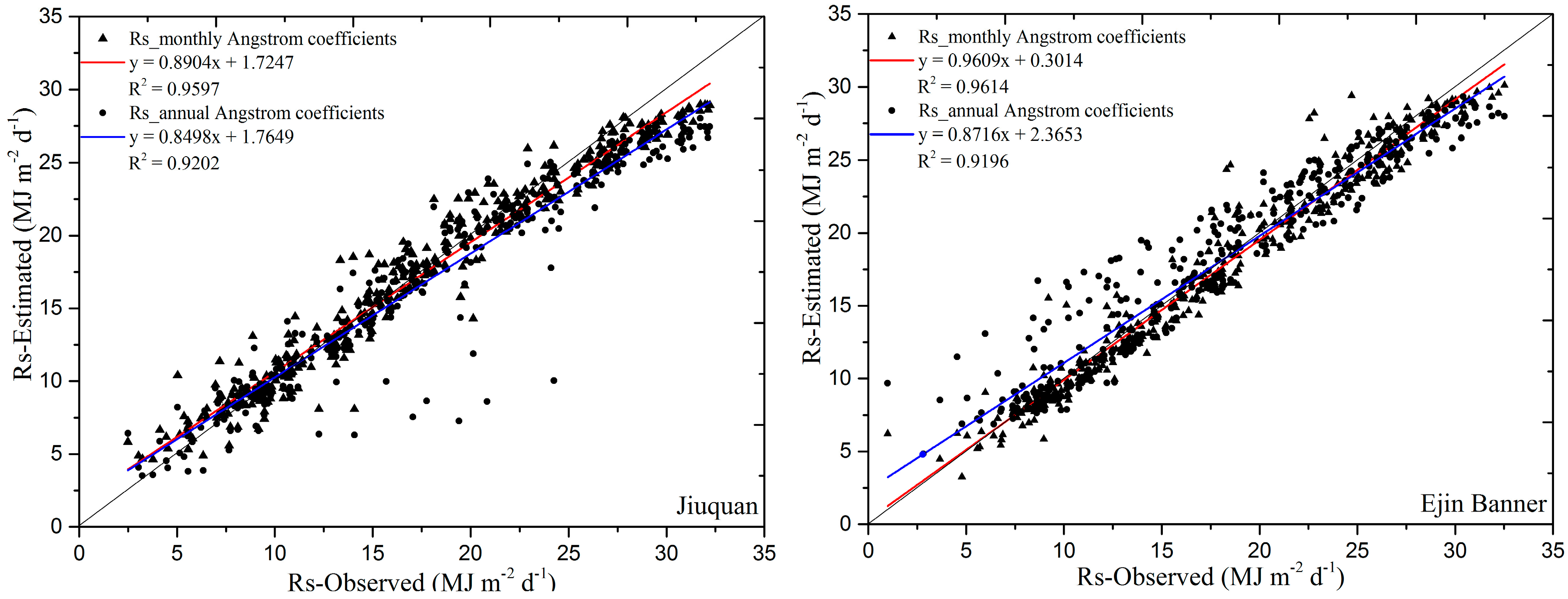
3.2. Validation of the Global Solar Radiation
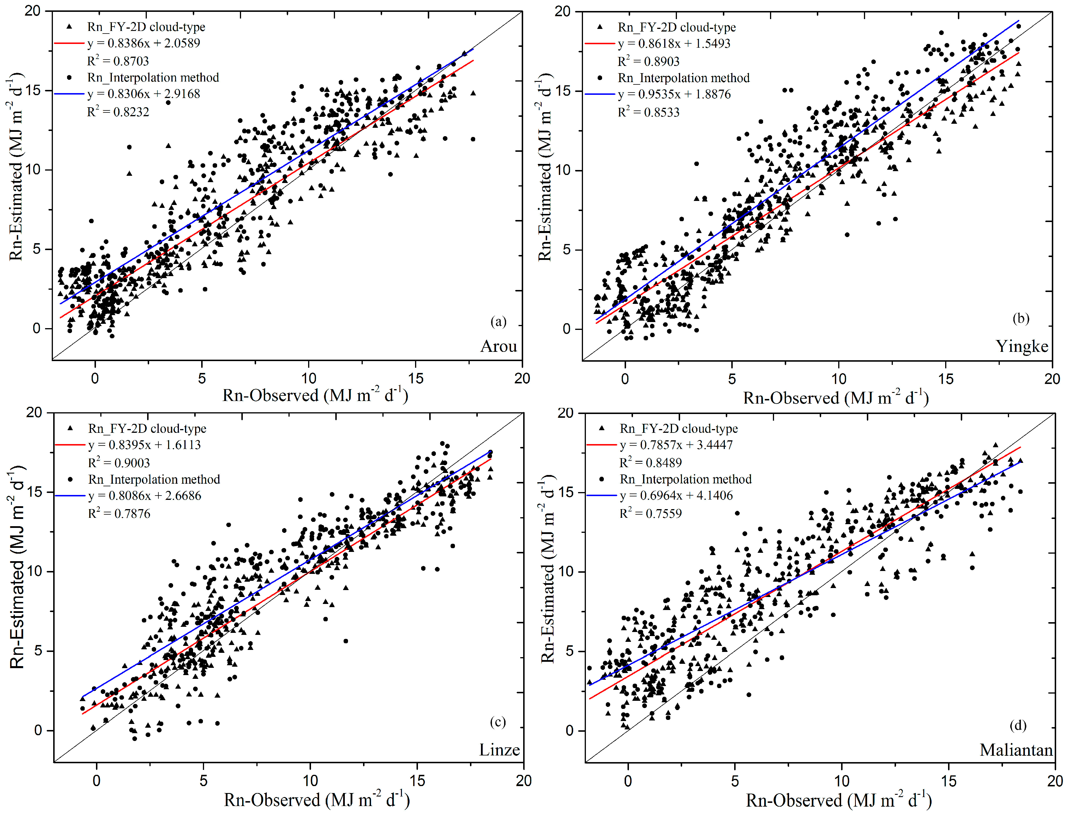
3.3. Calibration of Net Longwave Radiation
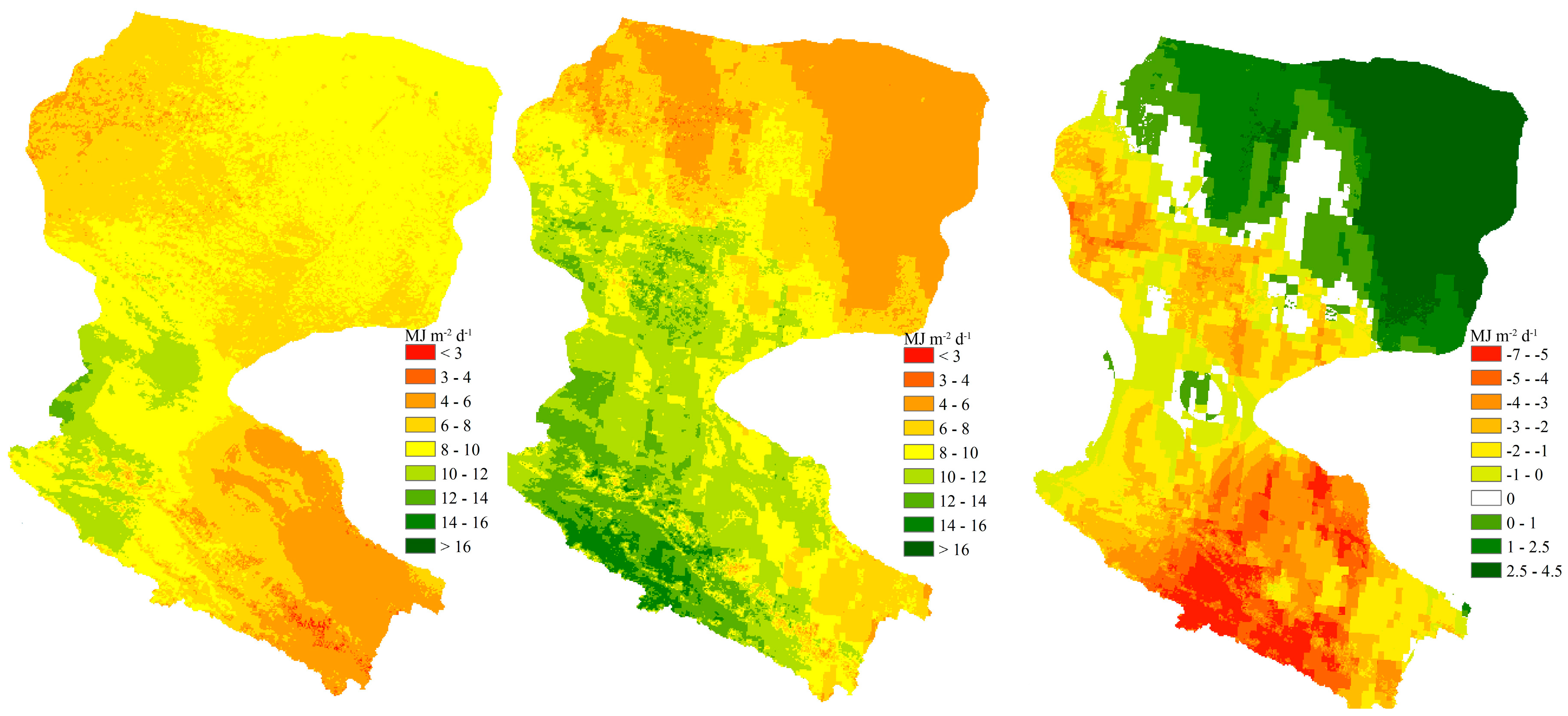
3.4. Net Radiation over the Heihe River Basin
4. Discussion
5. Conclusions
Acknowledgments
Author Contributions
Conflicts of Interest
References
- De, P.; Lima, E.; Sediyama, G.C.; da Silva, B.B.; Gleriani, J.M.; Soares, V.P. Seasonality of net radiation in two sub-basins of Paracatu by the use of MODIS sensor products. Eng. Agric. 2012, 32, 1184–1196. [Google Scholar]
- Liu, G.S.; Liu, Y.; Xu, D. Comparison of evapotranspiration temporal scaling methods based on lysimeter measurements. J. Remote Sens. 2011, 15, 270–280. [Google Scholar]
- Liu, G.; Liu, Y.; Hafeez, M.; Xu, D.; Vote, C. Comparison of two methods to derive time series of actual evapotranspiration using eddy covariance measurements in the southeastern Australia. J. Hydrol. 2012, 454–455, 1–6. [Google Scholar] [CrossRef]
- Liu, G.; Hafeez, M.; Liu, Y.; Xu, D.; Vote, C. A novel method to convert daytime evapotranspiration into daily evapotranspiration based on variable canopy resistance. J. Hydrol. 2012, 414–415, 278–283. [Google Scholar] [CrossRef]
- Suttles, J.T.; Ohring, G. Surface radiation budget for climate applications. NASA Ref. Publ. 1986, 1169, 1–123. [Google Scholar]
- Ramanathan, V. The role of Earth radiation budget studies in climate and general circulation research. J. Geophys. Res. 1987, 92, 4075–4095. [Google Scholar] [CrossRef]
- Zhou, X.; Tang, B.; Wu, H.; Li, Z. Estimating net surface longwave radiation from net surface shortwave radiation for cloudy skies. Int. J. Remote Sens. 2013, 34, 8104–8117. [Google Scholar] [CrossRef]
- Liang, S. Narrowband to broadband conversions of land surface albedo I: Algorithms. Remote Sens. Environ. 2001, 76, 213–238. [Google Scholar] [CrossRef]
- Angstrom, A. Solar and terrestrial radiation. Report to the international commission for solar research on actinometric investigations of solar and atmospheric radiation. Q. J. R. Meteorol. Soc. 1924, 50, 121–126. [Google Scholar] [CrossRef]
- Swartman, R.K.; Ogunlade, O. Solar radiation estimates from common parameters. Sol. Energy 1967, 11, 170–172. [Google Scholar] [CrossRef]
- Gariepy, J. Estimation of Extra-Terrestrial Solar Radiation (Estimation du Rayonnementsolaire Global); Internal Report, Service of Meteorology; Government of Quebec: Quebec City, QC, Canada, 1980.
- Lewis, G. Estimates of irradiance over Zimbabwe. Sol. Energy 1983, 31, 609–612. [Google Scholar] [CrossRef]
- Hargreaves, G.L.; Hargreaves, G.H.; Riley, J.P. Irrigation water requirements for the Senegal River Basin. J. Irrig. Drain. Eng. 1985, 111, 265–275. [Google Scholar] [CrossRef]
- Bahel, V.; Bakhsh, H.; Srinivasan, R. A correlation for estimation of global solar radiation. Energy 1987, 12, 131–135. [Google Scholar] [CrossRef]
- Ojosu, J.O.; Komolafe, L.K. Models for estimating solar radiation availability in south western Nigeria. Niger. J. Sol. Energy 1987, 6, 69–77. [Google Scholar]
- Ododo, J.C.; Sulaiman, A.T.; Aidan, J.; Yuguda, M.M.; Ogbu, F.A. The importance of maximum air temperature in the parameterization of solar radiation in Nigeria. Renew. Energy 1995, 6, 751–763. [Google Scholar] [CrossRef]
- Allen, R.G. Self-calibrating method for estimating solar radiation from air temperature. J. Hydrol. Eng. 1997, 2, 56–67. [Google Scholar] [CrossRef]
- Supit, I.; van Kappel, R.R. A simple method to estimate global radiation. Sol. Energy 1998, 63, 147–160. [Google Scholar] [CrossRef]
- Hussain, M.; Rahman, L.; Rahman, M.M. Techniques to obtain improved predictions of global radiation from sunshine duration. Renew. Energy 1999, 18, 263–275. [Google Scholar] [CrossRef]
- Lin, W.; Lu, E. Validation of eight sunshine-based global radiation models with measured data at seven places in Yunnan Province, China. Energy Convers. Manag. 1999, 40, 519–525. [Google Scholar] [CrossRef]
- Inci, T.T.; Emin, O. A study of estimating solar radiation in Elazig using geographical and meteorological data. Energy Convers. Manag. 1999, 40, 1577–1584. [Google Scholar]
- Thornton, P.E.; Running, S.W. An improved algorithm for estimating incident daily solar radiation from measurements of temperature, humidity, and precipitation. Agric. For. Meteorol. 1999, 93, 211–228. [Google Scholar] [CrossRef]
- Meza, F.; Varas, E. Estimation of mean monthly solar global radiation as a function of temperature. Agric. For. Meteorol. 2000, 100, 231–241. [Google Scholar] [CrossRef]
- Muneer, T.; Gul, M.S. Evaluation of sunshine and cloud cover based models for generating solar radiation data. Energy Convers. Manag. 2000, 41, 461–482. [Google Scholar] [CrossRef]
- Castellvi, F. A new simple method for estimating monthly and daily solar radiation. Performance and comparison with other methods at Lleida (NE Spain); a semiarid climate. Theor. Appl. Climatol. 2001, 69, 231–238. [Google Scholar] [CrossRef]
- Winslow, J.C.; Hunt, E.R.; Piper, S.C. A globally applicable model of daily solar irradiance estimated from air temperature and precipitation data. Ecol. Model. 2001, 143, 227–243. [Google Scholar] [CrossRef]
- Irmak, S.; Irmak, A.; Jones, J.W.; Howell, T.A.; Jacobs, J.M.; Allen, R.G.; Hoogenboom, G. Predicting daily net radiation using minimum climatological data. J. Irrig. Drain. Eng. 2003, 129, 256–269. [Google Scholar] [CrossRef]
- El-Metwally, M. Simple new methods to estimate global solar radiation based on meteorological data in Egypt. Atmos. Res. 2004, 69, 217–239. [Google Scholar] [CrossRef]
- Almorox, J.; Hontoria, C. Global solar radiation estimation using sunshine duration in Spain. Energy Convers. Manag. 2004, 45, 1529–1535. [Google Scholar] [CrossRef]
- Chen, R.; Ersi, K.; Yang, J.; Lu, S.; Zhao, W. Validation of five global radiation models with measured daily data in China. Energy Convers. Manag. 2004, 45, 1759–1769. [Google Scholar] [CrossRef]
- Rensheng, C.; Shihua, L.; Ersi, K.; Jianping, Y.; Xibin, J. Estimating daily global radiation using two types of revised models in China. Energy Convers. Manag. 2006, 47, 865–878. [Google Scholar] [CrossRef]
- Chen, R.; Kang, E.; Ji, X.; Yang, J.; Zhang, Z. Trends of the global radiation and sunshine hours in 1961–1998 and their relationships in China. Energy Convers. Manag. 2006, 47, 2859–2866. [Google Scholar] [CrossRef]
- Chen, R.; Kang, E.; Lu, S.; Yang, J.; Ji, X.; Zhang, Z.; Zhang, J. New methods to estimate global radiation based on meteorological data in China. Energy Convers. Manag. 2006, 47, 2991–2998. [Google Scholar] [CrossRef]
- Jin, Z.; Wu, Y.; Gang, Y. General formula for estimation of monthly average daily global solar radiation in China. Energy Convers. Manag. 2005, 46, 257–268. [Google Scholar] [CrossRef]
- Kadir, B. Correlations for estimation of daily global solar radiation with hours of bright sunshine in Turkey. Energy 2009, 34, 485–501. [Google Scholar]
- Wu, W.; Tang, X.P.; Yang, C.; Guo, N.J.; Liu, H.B. Spatial estimation of monthly mean daily sunshine hours and solar radiation across mainland China. Renew. Energy 2013, 57, 546–553. [Google Scholar] [CrossRef]
- Zhao, N.; Zeng, X.; Han, S. Solar radiation estimation using sunshine hour and air pollution index in China. Energy Convers. Manag. 2013, 76, 846–851. [Google Scholar] [CrossRef]
- Yang, K.; Huang, G.W.; Tamai, N. A hybrid model for estimating global solar radiation. Sol. Energy 2001, 70, 13–22. [Google Scholar] [CrossRef]
- Power, H.C. Estimating clear-sky beam irradiation from sunshine duration. Sol. Energy 2001, 71, 217–224. [Google Scholar] [CrossRef]
- Tiba, C. Solar radiation in the Brazilian northeast. Renew. Energy 2001, 22, 565–578. [Google Scholar] [CrossRef]
- Trnka, M.; Žalud, Z.; Eitzinger, J.; Dubrovský, M. Global solar radiation in Central European lowlands estimated by various empirical formulae. Agric. For. Meteorol. 2005, 131, 54–76. [Google Scholar] [CrossRef]
- Yohanna, J.K.; Itodo, I.N.; Umogbai, V.I. A model for determining the global solar radiation for Makurdi, Nigeria. Renew. Energy 2011, 36, 1989–1992. [Google Scholar] [CrossRef]
- Li, M.; Tang, X.; Wu, W.; Liu, H. General models for estimating daily global solar radiation for different solar radiation zones in mainland China. Energy Convers. Manag. 2013, 70, 139–148. [Google Scholar] [CrossRef]
- Ertekin, C.; Yaldiz, O. Comparison of some existing models for estimating global solar radiation for Antalya (Turkey). Energy Convers. Manag. 2000, 41, 311–330. [Google Scholar] [CrossRef]
- Robaa, S.M. Validation of the existing models for estimating global solar radiation over Egypt. Energy Convers. Manag. 2009, 50, 184–193. [Google Scholar] [CrossRef]
- Wu, B.F.; Liu, S.F.; Zhu, W.W.; Yu, M.Z.; Yan, N.N.; Xing, Q. A method to estimate sunshine duration using cloud classification data from a geostationary meteorological satellite (FY-2D) over the Heihe River Basin. Sensors 2016, 16, 1859. [Google Scholar] [CrossRef] [PubMed]
- Allen, R.G.; Pereira, L.S.; Raes, D.; Smith, M. Crop Evapotranspiration: Guidelines for Computing Crop Water Requirements; Irrigation and Drainage Paper 56; FAO: Rome, Italy, 1998. [Google Scholar]
- Ertekin, C.; Evrendilek, F. Spatio-temporal modeling of global solar radiation dynamics as a function of sunshine duration for Turkey. Agric. For. Meteorol. 2007, 145, 36–47. [Google Scholar] [CrossRef]
- Tian, H. Remote-Sensed Estimates of Evapotranspiration over a Complex Terrain of the Inland Hei River Basin. Ph.D. Dissertation, Cold and Arid Regions Environment and Engineering Research Insitute, Academy of Sciences, Lanzhou, China, June 2008. [Google Scholar]
- Huang, C.; Li, Y.; Gu, J. Improving Estimation of Evapotranspiration under Water-Limited Conditions Based on SEBS and MODIS Data in Arid Regions. Remote Sens. 2015, 7, 16795–16814. [Google Scholar] [CrossRef]
- Chelbi, M.; Gagnon, Y.; Waewsak, J. Solar radiation mapping using sunshine duration-based models and interpolation techniques: Application to Tunisia. Energy Convers. Manag. 2015, 101, 203–215. [Google Scholar] [CrossRef]
- Matsui, H.; Osawa, K. Calibration effects of the net longwave radiation equation in penman-type methods at Tateno, Japan. Hydrol. Res. Lett. 2015, 9, 113–117. [Google Scholar] [CrossRef]
- Jensen, M.E.; Burman, R.D.; Allen, R.G. Evapotranspiration and Irrigation Water Requirements; ASCE Manual 70; American Society of Civil Engineers: New York, NY, USA, 1990. [Google Scholar]
- Yin, Y.; Wu, S.; Zheng, D.; Yang, Q. Radiation calibration of FAO56 Penman-Monteith model to estimate reference crop evapotranspiration in China. Agric. Water Manag. 2008, 95, 77–84. [Google Scholar] [CrossRef]
- Kjaersgaard, J.H.; Cuenca, R.H.; Martinez-Cob, A.; Gavilan, P.; Plauborg, F.; Mollerup, M.; Hansen, S. Comparison of the performance of net radiation calculation models. Theor. Appl. Climatol. 2009, 98, 57–66. [Google Scholar] [CrossRef]
- Zhu, W.; Wu, B.; Yan, N.; Feng, X.; Xing, Q. A method to estimate diurnal surface soil heat flux from MODIS data for a sparse vegetation and bare soil. J. Hydrol. 2014, 511, 139–150. [Google Scholar] [CrossRef]
- Gao, Y.; Hu, Y. Advances in HEIFE Research (1987–1994), 1st ed.; Special Issue; China Meteorological: Beijing, China, 1994. [Google Scholar]
- Annai, M. Remote Sensing Information Model; Peking University Press: Beijing, China, 1997. [Google Scholar]
- Ma, Y.; Dai, Y.; Ma, W.; Li, M.; Wang, J.; Wen, J.; Sun, F. Satellite remote sensing parameterization of regional land surface heat fluxes over heterogeneous surface of arid and semi-arid areas. Plateau Meteorol. 2004, 23, 139–146. [Google Scholar]
- Ma, Y.M.; Ma, W.Q.; Li, M.S.; Sun, F.L.; Wang, J.M. Remote sensing parameterization of land surface heat fluxes over the middle reaches of the Heihe river. J. Desert Res. 2004, 24, 392–401. [Google Scholar]
- Li, X.; Li, X.; Li, Z.; Ma, M.; Wang, J.; Xiao, Q.; Liu, Q.; Che, T.; Chen, E.; Yan, G.; et al. Watershed allied telemetry experimental Research. J. Geophys. Res. 2009, 114, D22103. [Google Scholar] [CrossRef]
- Li, X.; Cheng, G.; Liu, S.; Xiao, Q.; Ma, M.; Jin, R.; Che, T.; Liu, Q.; Wang, W.; Qi, Y.; et al. Heihe watershed allied telemetry experimental Research (HiWATER): Scientific objectives and experimental design. Bull. Am. Meteorol. Soc. 2013, 94, 1145–1160. [Google Scholar] [CrossRef]
- Ackerman, S.; Strabala, K.; Menzel, P.; Frey, R.; Moeller, C.; Gumley, L.; Baum, B.; Seemann, S.W.; Zhang, H. Discriminating Clear-Sky from Cloud with MODIS Algorithm. Available online: http://library.ssec.wisc.edu/research_Resources/publications/pdfs/SSECPUBS/SSEC_Publication_No_06_10_A1.pdf (accessed on 3 January 2017).
- Wang, Y.; Li, X.; Tang, S. Validation of the SEBS-derived sensible heat for FY3A/VIRR and TERRA/MODIS over an alpine grass region using las measurements. Int. J. Appl. Earth Obs. 2013, 23, 226–233. [Google Scholar] [CrossRef]
- Xu, J.M. Development and trend of China meteorological satellite. Sci. Technol. Rev. 2010, 28, 3–13. [Google Scholar]
- Xu, J.M. Chinese meteorological satellites, achievements and applications. Meteorol. Mon. 2010, 36, 94–100. [Google Scholar]
- Qian, Q.J.; Wu, B.F.; Xiong, J. Interpolation system for generating meteorological surfaces using to compute evapotranspiration in Haihe River Basin. In Proceedings of the IEEE International Geoscience and Remote Sensing Symposium, Milan, Italy, 26–31 July 2005; pp. 616–619.
- Prescott, J.A. Evaporation from a water surface in relation to solar radiation. Trans. R. Soc. Sci. 1940, 64, 114–225. [Google Scholar]
- Revfeim, K. On the relationship between radiation and mean daily sunshine. Agric. For. Meteorol. 1997, 86, 183–191. [Google Scholar] [CrossRef]
- Brunt, D. Notes on radiation in the atmosphere. I. Q. J. R. Meteorol. Soc. 1932, 58, 389–420. [Google Scholar] [CrossRef]
- Penman, H.L. Natural evaporation from open water, bare soil and grass. Proc. R. Soc. A 1948, 193, 120–145. [Google Scholar] [CrossRef]
- Bastiaanssen, W.G.M. Regionalization of Surface Flux Densities and Moisture Indicators in Composite Terrain: A Remote Sensing Approach under Clear Skies in Mediterranean Climates. Ph.D. Dissertation, Wageningen Agricultural University, Wageningen, The Netherlands, 1995. [Google Scholar]
- Levenberg, K. A method for the solution of certain nonlinear problems in least squares. Q. Appl. Math. 1944, 2, 164–168. [Google Scholar] [CrossRef]
- Nash, J.E.; Sutcliffe, J.V. River flow forecasting through conceptual models part I—A discussion of principles. J. Hydrol. 1970, 10, 282–290. [Google Scholar] [CrossRef]
- Cai, J.; Liu, Y.; Lei, T.; Pereira, L.S. Estimating reference evapotranspiration with the FAO Penman-Monteith equation using daily weather forecast messages. Agric. For. Meteorol. 2007, 145, 22–35. [Google Scholar] [CrossRef]
- Legates, D.R.; McCabe, G.J. Evaluating the use of “goodness-of-fit” measures in hydrologic and hydroclimatic model validation. Water Resour. Res. 1999, 35, 233–241. [Google Scholar] [CrossRef]
- Fox, D.G. Judging air quality model performance. Bull. Am. Meteorol. Soc. 1981, 62, 599–609. [Google Scholar] [CrossRef]
- Willmott, C.J. Some comments on the evaluation of model performance. Bull. Am. Meteorol. Soc. 1982, 63, 1309–1313. [Google Scholar] [CrossRef]
- Isaaks, E.H.; Srivastava, R.M. An Introduction to Applied Geostatistics; Oxford University Press: New York, NY, USA, 1989. [Google Scholar]


| Station Name | Longitude (°, E) | Latitude (°, N) | Elevation (m) | Land Cover | Observation Period | Location |
|---|---|---|---|---|---|---|
| Huazhaizi | 100.32 | 38.77 | 1731 | Bare Gobi | 2008.06–2010.12 | Midstream |
| Yingke | 100.41 | 38.86 | 1519 | Maize | 2007.11–2010.12 | Midstream |
| Arou | 100.46 | 38.04 | 3033 | Alpine meadow | 2007.07–2010.12 | Upstream |
| Linze | 100.07 | 39.25 | 1394 | Grass | 2007.10–2008.10 | Midstream |
| Maliantan | 100.30 | 38.55 | 2817 | Sparse grass | 2007.11–2009.12 | Upstream |
| Yakou | 100.24 | 38.01 | 4147 | Alpine meadow | 2007.10–2009.10 | Upstream |
| Binggou | 100.22 | 38.07 | 3449 | Sparse grass | 2007.9–2009.9 | Upstream |
| Station Name | Longitude (°, E) | Latitude (°, N) | Elevation (m) | Land Cover | Observation Period | Location |
|---|---|---|---|---|---|---|
| Ejin Banner | 101.07 | 41.95 | 941 | Sparse forests | 1997–2006 | Downstream |
| Dunhuang | 94.68 | 40.15 | 1139 | Sparse forests | 1997–2006 | Midstream (outside) |
| Jiuquan | 98.48 | 39.77 | 1477 | Farmland | 1997–2006 | Midstream |
| Minqin | 103.08 | 38.63 | 1367 | Urban | 1997–2006 | Midstream |
| Gangcha | 100.13 | 37.33 | 3302 | Bare | 1997–2006 | Upstream (outside) |
| Code | Cloud Type (Cloud Classification) | Factor |
|---|---|---|
| 0/1 | Clear Sky | 0.9 |
| 11 | Mixed pixels | 0.21 |
| 12 | Altostratus or Nimbostratus | 0.25 |
| 13 | Cirrostratus | 0.51 |
| 14 | Cirrus spissatus | 0.24 |
| 15 | Cumulonimbus | 0.13 |
| 21 | Stratocumulus or Altocumulus | 0.35 |
| Station | Month | R2 | as | bs | Station | Month | R2 | as | bs |
|---|---|---|---|---|---|---|---|---|---|
| Ejin Banner | 1 | 0.88 | 0.27 | 0.49 | Jiuquan | 7 | 0.98 | 0.21 | 0.47 |
| Ejin Banner | 2 | 0.96 | 0.28 | 0.47 | Jiuquan | 8 | 0.94 | 0.23 | 0.50 |
| Ejin Banner | 3 | 0.94 | 0.25 | 0.45 | Jiuquan | 9 | 0.97 | 0.24 | 0.56 |
| Ejin Banner | 4 | 0.95 | 0.23 | 0.51 | Jiuquan | 10 | 0.92 | 0.22 | 0.52 |
| Ejin Banner | 5 | 0.96 | 0.25 | 0.55 | Jiuquan | 11 | 0.95 | 0.25 | 0.54 |
| Ejin Banner | 6 | 0.92 | 0.24 | 0.47 | Jiuquan | 12 | 0.96 | 0.21 | 0.51 |
| Ejin Banner | 7 | 0.98 | 0.23 | 0.54 | Minqin | 1 | 0.98 | 0.21 | 0.52 |
| Ejin Banner | 8 | 0.97 | 0.22 | 0.56 | Minqin | 2 | 0.92 | 0.20 | 0.51 |
| Ejin Banner | 9 | 0.91 | 0.20 | 0.52 | Minqin | 3 | 0.94 | 0.19 | 0.52 |
| Ejin Banner | 10 | 0.95 | 0.22 | 0.57 | Minqin | 4 | 0.94 | 0.24 | 0.54 |
| Ejin Banner | 11 | 0.91 | 0.26 | 0.53 | Minqin | 5 | 0.93 | 0.17 | 0.59 |
| Ejin Banner | 12 | 0.94 | 0.25 | 0.55 | Minqin | 6 | 0.89 | 0.19 | 0.51 |
| Dunhuang | 1 | 0.97 | 0.24 | 0.51 | Minqin | 7 | 0.88 | 0.24 | 0.56 |
| Dunhuang | 2 | 0.89 | 0.16 | 0.55 | Minqin | 8 | 0.94 | 0.24 | 0.54 |
| Dunhuang | 3 | 0.89 | 0.22 | 0.58 | Minqin | 9 | 0.93 | 0.23 | 0.58 |
| Dunhuang | 4 | 0.92 | 0.21 | 0.51 | Minqin | 10 | 0.89 | 0.24 | 0.59 |
| Dunhuang | 5 | 0.89 | 0.23 | 0.57 | Minqin | 11 | 0.90 | 0.18 | 0.58 |
| Dunhuang | 6 | 0.92 | 0.21 | 0.54 | Minqin | 12 | 0.91 | 0.21 | 0.51 |
| Dunhuang | 7 | 0.95 | 0.18 | 0.54 | Gangcha | 1 | 0.93 | 0.23 | 0.53 |
| Dunhuang | 8 | 0.93 | 0.24 | 0.55 | Gangcha | 2 | 0.91 | 0.24 | 0.62 |
| Dunhuang | 9 | 0.92 | 0.28 | 0.56 | Gangcha | 3 | 0.89 | 0.34 | 0.48 |
| Dunhuang | 10 | 0.90 | 0.23 | 0.48 | Gangcha | 4 | 0.93 | 0.36 | 0.54 |
| Dunhuang | 11 | 0.91 | 0.21 | 0.49 | Gangcha | 5 | 0.88 | 0.21 | 0.54 |
| Dunhuang | 12 | 0.90 | 0.23 | 0.52 | Gangcha | 6 | 0.89 | 0.24 | 0.56 |
| Jiuquan | 1 | 0.98 | 0.21 | 0.54 | Gangcha | 7 | 0.92 | 0.23 | 0.62 |
| Jiuquan | 2 | 0.98 | 0.22 | 0.52 | Gangcha | 8 | 0.89 | 0.30 | 0.55 |
| Jiuquan | 3 | 0.90 | 0.19 | 0.44 | Gangcha | 9 | 0.91 | 0.21 | 0.59 |
| Jiuquan | 4 | 0.95 | 0.27 | 0.55 | Gangcha | 10 | 0.93 | 0.23 | 0.48 |
| Jiuquan | 5 | 0.93 | 0.21 | 0.49 | Gangcha | 11 | 0.89 | 0.21 | 0.51 |
| Jiuquan | 6 | 0.96 | 0.20 | 0.54 | Gangcha | 12 | 0.88 | 0.21 | 0.59 |
| Station | Angstrom Coefficients | Time | R2 | MBE MJ·m−2·d−1 | MAE MJ·m−2·d−1 | RMSE MJ·m−2·d−1 | d | NSE |
|---|---|---|---|---|---|---|---|---|
| Jiuquan | Monthly | 2008.1.1–2008.12.31 | 0.9597 | −0.1849 | 1.2432 | 1.6419 | 0.9873 | 0.9541 |
| Annual | 2008.1.1–2008.12.31 | 0.9202 | −0.8533 | 1.5853 | 2.3920 | 0.9723 | 0.9026 | |
| Ejin Banner | Monthly | 2008.1.1–2008.12.31 | 0.9614 | −0.3860 | 1.1291 | 1.4946 | 0.9894 | 0.9588 |
| Annual | 2008.1.1–2008.12.31 | 0.9196 | 0.1035 | 1.5692 | 2.1187 | 0.9769 | 0.9172 |
| Station | Sunshine Duration | Time | R2 | MBE MJ·m−2·d−1 | MAE MJ·m−2·d−1 | RMSE MJ·m−2·d−1 | d | NSE |
|---|---|---|---|---|---|---|---|---|
| Arou | FY-2D cloud-type | 2008.1.1–2008.12.31 | 0.8703 | 1.0580 | 1.6908 | 2.1600 | 0.9518 | 0.8279 |
| Interpolation method | 2008.1.1–2008.12.31 | 0.8232 | 1.8667 | 2.3700 | 2.8752 | 0.9172 | 0.6950 | |
| Yingke | FY-2D cloud-type | 2008.1.1–2008.12.31 | 0.8903 | 0.5411 | 1.4519 | 1.8196 | 0.9684 | 0.8837 |
| Interpolation method | 2008.1.1–2008.12.31 | 0.8533 | 1.5481 | 2.0199 | 2.5923 | 0.9454 | 0.7640 | |
| Linze | FY-2D cloud-type | 2008.1.1–2008.12.31 | 0.9003 | 0.2162 | 1.2396 | 1.5925 | 0.9771 | 0.9160 |
| Interpolation method | 2008.1.1–2008.12.31 | 0.7876 | 1.0041 | 1.9807 | 2.4724 | 0.9492 | 0.7975 | |
| Maliantan | FY-2D cloud-type | 2008.1.1–2008.12.31 | 0.8489 | 1.9696 | 2.3552 | 2.8958 | 0.9231 | 0.7147 |
| Interpolation method | 2008.1.1–2008.12.31 | 0.7559 | 2.0506 | 2.7992 | 3.3768 | 0.8892 | 0.6121 |
© 2017 by the authors; licensee MDPI, Basel, Switzerland. This article is an open access article distributed under the terms and conditions of the Creative Commons Attribution (CC-BY) license (http://creativecommons.org/licenses/by/4.0/).
Share and Cite
Wu, B.; Liu, S.; Zhu, W.; Yan, N.; Xing, Q.; Tan, S. An Improved Approach for Estimating Daily Net Radiation over the Heihe River Basin. Sensors 2017, 17, 86. https://doi.org/10.3390/s17010086
Wu B, Liu S, Zhu W, Yan N, Xing Q, Tan S. An Improved Approach for Estimating Daily Net Radiation over the Heihe River Basin. Sensors. 2017; 17(1):86. https://doi.org/10.3390/s17010086
Chicago/Turabian StyleWu, Bingfang, Shufu Liu, Weiwei Zhu, Nana Yan, Qiang Xing, and Shen Tan. 2017. "An Improved Approach for Estimating Daily Net Radiation over the Heihe River Basin" Sensors 17, no. 1: 86. https://doi.org/10.3390/s17010086
APA StyleWu, B., Liu, S., Zhu, W., Yan, N., Xing, Q., & Tan, S. (2017). An Improved Approach for Estimating Daily Net Radiation over the Heihe River Basin. Sensors, 17(1), 86. https://doi.org/10.3390/s17010086