
Computing the Deflection of the Vertical for Improving Aerial Surveys: A Comparison between EGM2008 and ITALGEO05 Estimates


Abstract
:1. Introduction
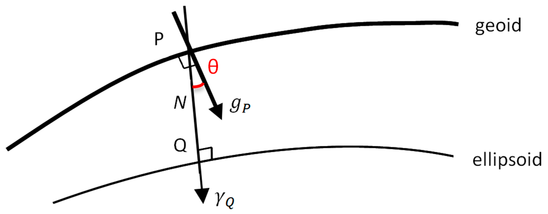
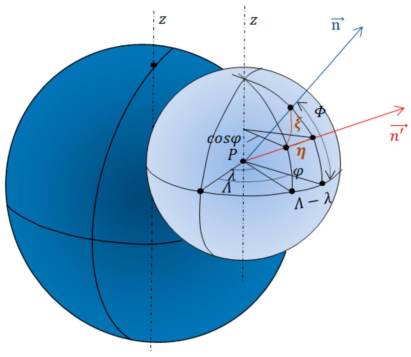
2. Predicting the Deflection of the Vertical Using Gravity Data and the Collocation Method
- γ: normal gravity in P;
- ϕ: latitude;
- λ: longitude;
- r: distance of P from the geocenter.
- Δgr: residual gravity anomalies;
- Δgobs: observed gravity anomalies;
- ΔgGGM: contribution of a Global Geopotential Model;
- ΔgRTC: gravity anomalies correction due to terrain.
- and : cross-covariances between (ξr, ηr) and Δgr;
- : auto-covariance of Δgr;
- n: noise in gravity;
- : noise variance.
3. The Deflection of the Vertical by Spherical Harmonic Expansion: the EGM2008 GGM
- ϕ, λ, r: spherical geocentric coordinates;
- a: semi-major axis of Earth;
- GM: gravitational constant times mass of Earth;
- n, m: degree and order of spherical harmonic;
- : fully normalized Legendre functions;
- , : fully normalized coefficients.
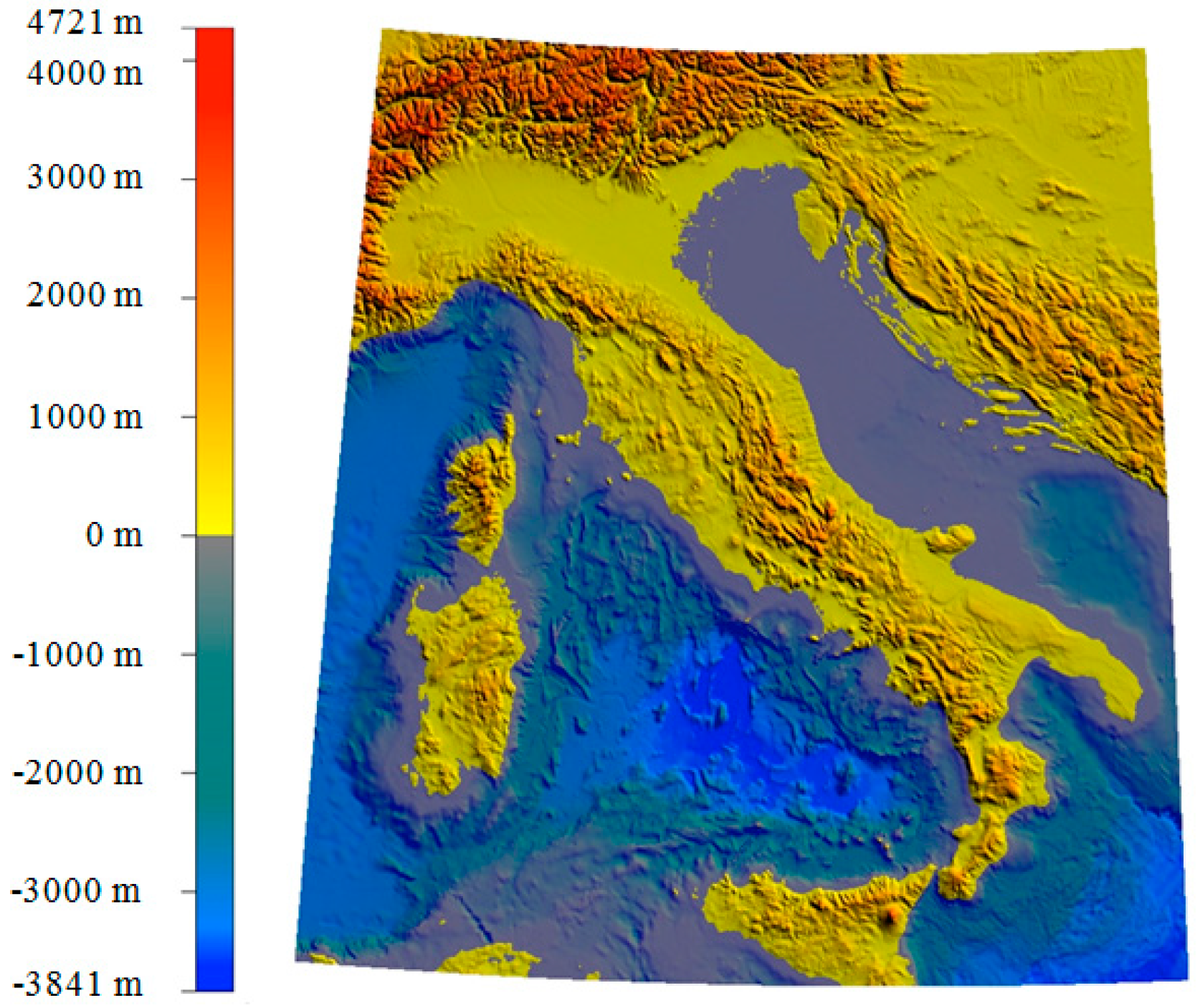
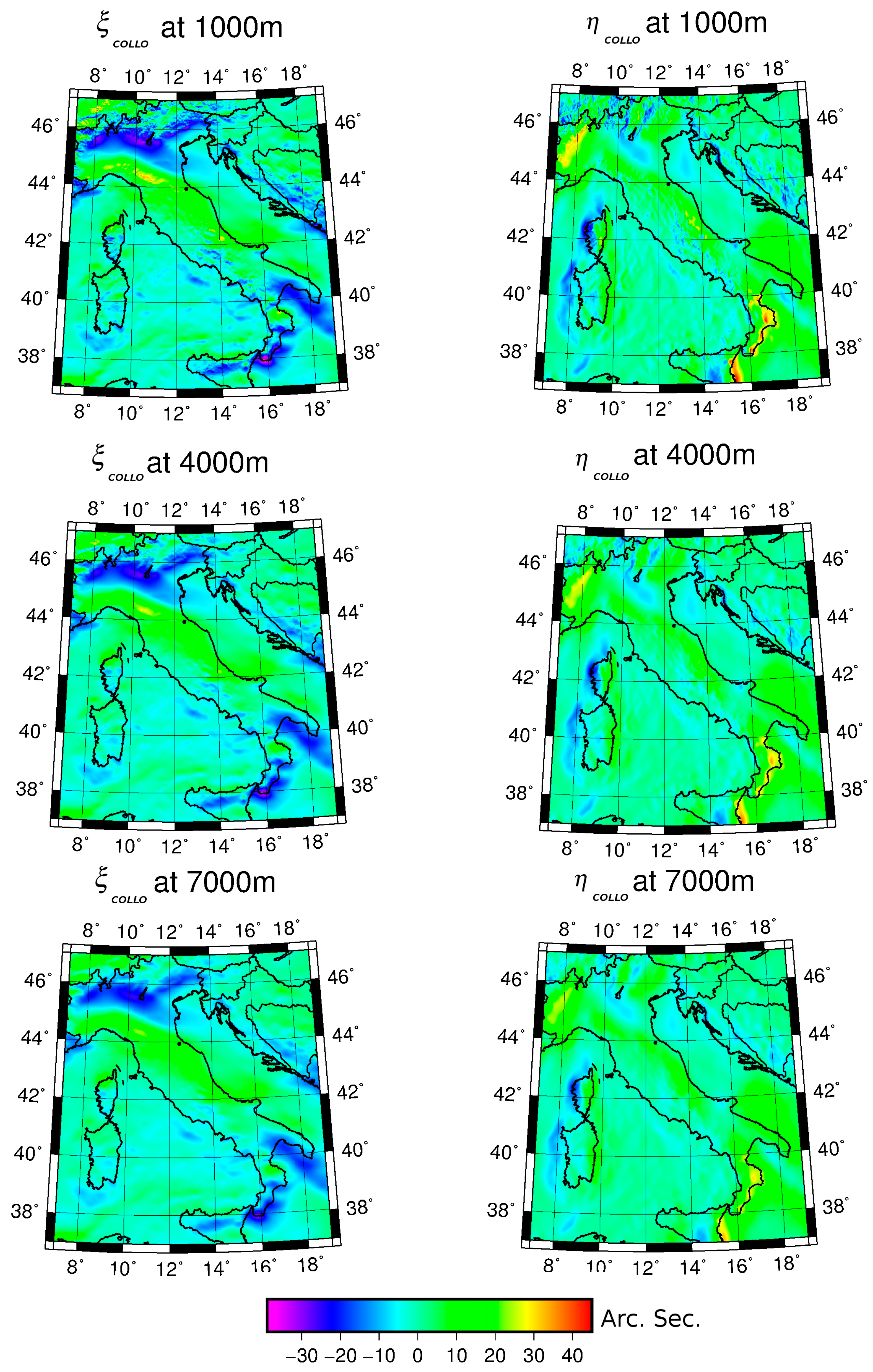
4. Comparison between Vertical Deflection Models Derived by Collocation and EGM2008 in the Central Mediterranean Area
5. Conclusions
Author Contributions
Conflicts of Interest
Abbreviations
| ITALGEO05 | Italian Geoid |
| EGM2008 | Earth Gravitational Model 2008 |
| GNSS/INS | Global Navigation Satellite System/Inertial Navigation System |
| DTM | Digital Terrain Model |
| GGM | Global Geopotential Model |
| RCR | Remove-Compute-Restore |
| RTC | Residual Terrain Correction |
| GRACE | Gravity Recovery and Climate Experiment |
| GPS | Global Positioning System |
| RMS | Root Mean Square |
| NGA | National Geospatial-Intelligence Agency |
| EIGEN-6C3 | European Improved Gravity model of the Earth by New techniques |
| SRTM | Shuttle Radar Topography Mission |
| LSC | Least Squares Collocation |
| DOV | Deflection Of the Vertical |
| FOV | Field Of View |
References
- Levine, S.A.; Gelb, A. Effect of deflections of the vertical on the performance of a terrestrial inertial navigation system. J. Spacecr. Rockets 1969, 6, 978–984. [Google Scholar]
- Bernstein, U.; Hess, R.I. The Effects of Vertical Deflections on Aircraft Inertial Navigation Systems. AIAA J. 1976, 14, 1377–1381. [Google Scholar]
- Li, X. An exact formula for the tilt correction in scalar airborne gravimetry. J. Appl. Geodesy 2011, 5, 81–85. [Google Scholar] [CrossRef]
- Jekeli, C. An analysis of vertical deflections derived from high-degree spherical harmonic models. J. Geodesy 1999, 73, 10–22. [Google Scholar] [CrossRef]
- Sanchez, R.D.; Hothem, L.D. Positional Accuracy of Airborne Integrated Global Positioning and Inertial Navigation Systems for Mapping in Glen Canyon, Arizona; US Department of the Interior, US Geological Survey: Reston, VA, USA, 2002.
- NovAtel Inc. NovAtel SPAN™. Aerial Photogrammetry Test Flight Results. 2010. Available online: http://mycoordinates.org/novatelwhitepaper.pdf (accessed on 15 April 2015).
- Grejner-Brzezinska, D.A.; Yi, Y.; Toth, C.; Anderson, R.; Davenport, J.; Kopcha, D.; Salman, R. On improved gravity modeling supporting direct georeferencing of multisensor systems. Proc. Int. Soc. Photogramm. Remote Sens. 2004, XXXV, 908–913. [Google Scholar]
- Goulden, T.; Hopkinson, C. Investigating the effect of the deflection of the vertical on LIDAR observations. Can. J. Remote Sens. 2010, 36 (Suppl. 2), S365–S375. [Google Scholar] [CrossRef]
- Pepe, M.; Prezioso, G.; Santamaria, R. Impact of vertical deflection on direct georeferencing of airborne images. Surv. Rev. 2015. [Google Scholar] [CrossRef]
- Heiskanen, W.; Moritz, H. Physical Geodesy; W.H. Freeman and Co.: San Francisco, CA, USA, 1967. [Google Scholar]
- Pavlis, N.K.; Holmes, S.A.; Kenyon, S.C.; Factor, J.K. An Earth Gravitational Model to Degree 2160: EGM2008. In Proceedings of the General Assembly of the EGU, Vienna, Austria, 13–18 April 2008.
- Tscheming, C.C.; Forsberg, R. Prediction of deflections of the vertical. In Proceedings of the Second International Symposium on Problems Related to the Redéfinition of North American Geodetic Networks, Arlington, VA, USA, 24–28 April 1978; pp. 117–134.
- Vaniček, P.; Krakiwsky, E.J. Geodesy: The Concepts, 2nd ed.; North Holland Publishing Company: Amsterdam, The Netherlands, 1986. [Google Scholar]
- Sansò, F.; Sideris, M.G. (Eds.) Geoid Determination, Theory and Methods; Springer: New York, NY, USA, 2013.
- Moritz, H. Advanced Physical Geodesy; Wichmann: Karlsruhe, Germany, 1989. [Google Scholar]
- Mayer-Gürr, T. The latest GRACE gravity field solution computed in Bonn. In Proceedings of the Joint International GSTM and SPP Symposium, Potsdam, Germany, 15–17 October 2007.
- Saleh, J.; Pavlis, N.K. The Development and evaluation of the global digital terrain model DTM2002. In Proceedings of the 3rd Meeting of the International Gravity and Geoid, Thessaloniki, Greece, 26–30 August 2002; pp. 207–222.
- Barzaghi, R.; Carrion, D. Testing EGM2008 in the central Mediterranean area, External Quality Evaluation Reports of EGM08. Newton’s Bull. 2009, 4, 133–143. [Google Scholar]
- Hirt, C.; Marti, U.; Bürki, B.; Featherstone, W.E. Assessment of EGM2008 in Europe using accurate astrogeodetic vertical deflections and omission error estimates from SRTM/DTM2006.0 residual terrain model data. J. Geophys. Res. Solid Earth 2010, 115, 1–13. [Google Scholar] [CrossRef]
- Huang, J.; Kotsakis, C. (Eds.) Newton’s Bulletin n° 4, External Quality Evaluation Report of EGM08; IGeS, Politecnico di Milano: Milan, Italy, 2009.
- Barthelmes, F. Definition of Functionals of the Geopotential and Their Calculation From Spherical Harmonic Models. Available online: http://publications.iass-potsdam.de/pubman/item/escidoc:104132:3/component/escidoc:104133/0902-2.pdf (accessed on 15 April 2015).
- Amante, C.; Eakins, B.W. ETOPO1 1 Arc-Minute Global Relief Model: Procedures, Data Sources and Analysis. NOAA Technical Memorandum NESDIS NGDC-24; National Geophysical Data Center, NOAA: Boulder, CO, USA, 2009. [CrossRef]
- Barzaghi, R.; Borghi, A.; Carrion, D.; Sona, G. Refining the estimate of the Italian quasi-geoid. Boll. Geod. Sci. Affin. 2007, 63, 145–158. [Google Scholar]
- Förste, C.; Bruinsma, S.; Flechtner, F.; Abrykosov, O.; Dahle, C.; Marty, J.; Lemoine, J.; Biancale, R.; Barthelmes, F.; Neumayer, K.; König, R. EIGEN-6C3—The latest Combined Global Gravity Field Model including GOCE data up to degree and order 1949 of GFZ Potsdam and GRGS Toulouse. In Proceedings of the 5th GOCE User Workshop, Paris, France, 25–28 November 2014.
- Werner, M. Shuttle Radar Topography Mission (SRTM), Mission Overview. J. Telecommun. (Frequenz) 2011, 55, 75–79. [Google Scholar] [CrossRef]
- Tscherning, C.C. Geoid Determination by Least-Squares Collocation Using GRAVSOFT; Lectures Notes of the International School for the Determination and Use of the Geoid; IGeS, DIIAR, Politecnico di Milano: Milano, Italy, 1994. [Google Scholar]


| 1000 m | ||||||
| Geopotential Model Component (EIGEN-6C3) | Residual Component | Terrain Component | ||||
| ξ (") | η (") | ξ (") | η (") | ξ (") | η (") | |
| Mean | −1.920 | 2.004 | 0.204 | 0.042 | −0.007 | 0.007 |
| Standard Deviation | 7.588 | 6.998 | 1.286 | 1.014 | 2.931 | 2.654 |
| Min | −39.123 | −29.447 | −9.4459 | −6.5066 | −28.2366 | −24.4967 |
| Max | 28.991 | 39.688 | 8.6725 | 5.8911 | 32.2476 | 21.8262 |
| 4000 m | ||||||
| Geopotential Model Component (EIGEN-6C3) | Residual Component | Terrain Component | ||||
| ξ (") | η (") | ξ (") | η (") | ξ (") | η (") | |
| Mean | −1.905 | −1.983 | 0.200 | 0.041 | −0.006 | 0.004 |
| Standard Deviation | 6.192 | 6.370 | 0.965 | 0.764 | 1.517 | 1.250 |
| Min | −33.768 | −24.727 | −6.723 | −4.724 | −15.062 | −14.141 |
| Max | 25.411 | 35.244 | 5.939 | 4.261 | 17.658 | 15.280 |
| 7000 m | ||||||
| Geopotential Model Component (EIGEN-6C3) | Residual Component | Terrain Component | ||||
| ξ (") | η (") | ξ (") | η (") | ξ (") | η (") | |
| Mean | −1.891 | 1.963 | 0.197 | 0.042 | −0.005 | 0.004 |
| Standard Deviation | 6.368 | 5.866 | 0.760 | 0.611 | 0.907 | 0.697 |
| Min | −29.512 | −20.946 | −4.8791 | −3.5069 | −7.9262 | −5.6898 |
| Max | 22.443 | 31.604 | 4.1568 | 3.3674 | 7.8965 | 6.1959 |
| 1000 m | 2000 m | 3000 m | ||||
| Δξ (") | Δη (") | Δξ (") | Δη (") | Δξ (") | Δη (") | |
| Mean | 0.199 | 0.065 | 0.198 | 0.063 | 0.195 | 0.063 |
| Standard Deviation | 2.088 | 2.055 | 1.622 | 1.607 | 1.109 | 1.099 |
| Min | −22.946 | −20.088 | −20.390 | −19.005 | −15.667 | −16.617 |
| Max | 21.858 | 28.769 | 19.148 | 26.360 | 13.539 | 21.816 |
| 4000 m | 5000 m | 7000 m | ||||
| Δξ (") | Δη (") | Δξ (") | Δη (") | Δξ (") | Δη (") | |
| Mean | 0.195 | 0.062 | 0.194 | 0.062 | 0.192 | 0.061 |
| Standard Deviation | 0.789 | 0.764 | 0.626 | 0.597 | 0.483 | 0.454 |
| Min | −12.166 | −10.902 | −7.899 | −6.000 | −3.526 | −2.411 |
| Max | 8.600 | 14.306 | 5.134 | 9.566 | 3.251 | 4.269 |
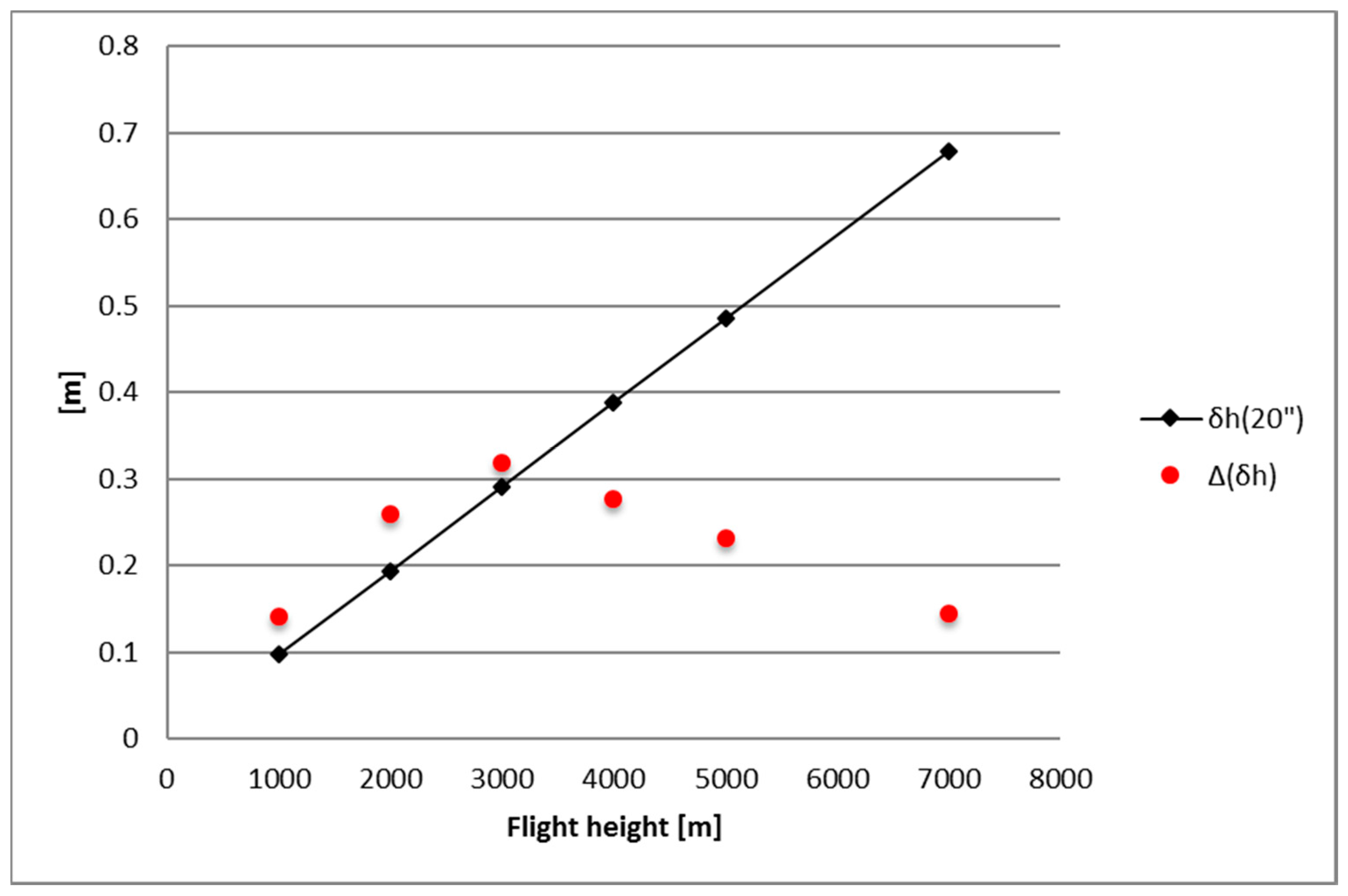
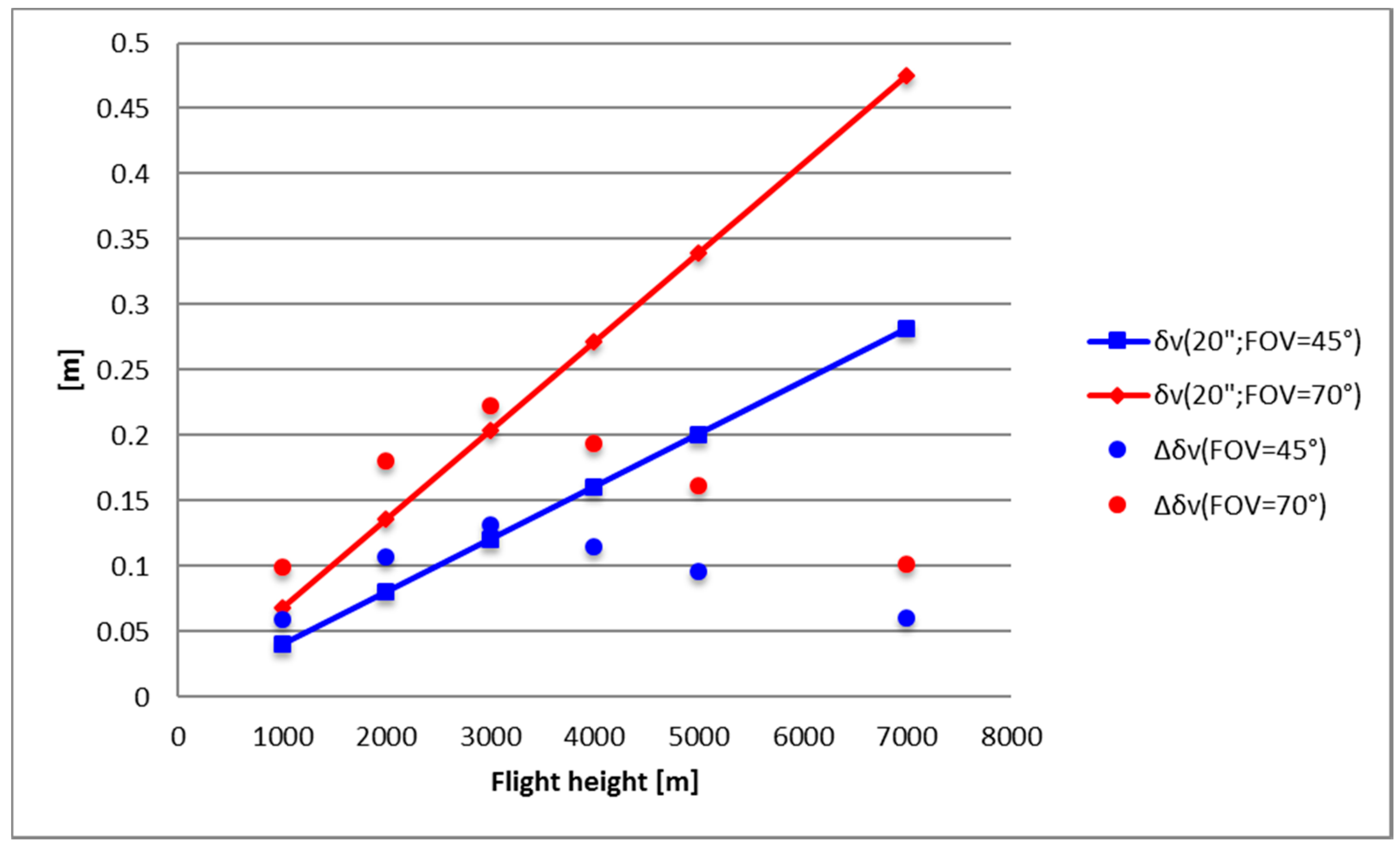
| 1000 m | 2000 m | 3000 m | ||||
| Max |Δδh| (m) | 0.142 | 0.259 | 0.318 | |||
| Max |Δδv| (m) | FOV = 45° | FOV = 70° | FOV = 45° | FOV = 70° | FOV = 45° | FOV = 70° |
| 0.059 | 0.099 | 0.107 | 0.181 | 0.132 | 0.223 | |
| 4000 m | 5000 m | 7000 m | ||||
| Max |Δδh| (m) | 0.277 | 0.232 | 0.145 | |||
| Max |Δδv| (m) | FOV = 45° | FOV = 70° | FOV = 45° | FOV = 45° | FOV = 45° | FOV = 45° |
| 0.115 | 0.194 | 0.096 | 0.162 | 0.060 | 0.102 | |
| 1000 m | 2000 m | 3000 m | ||||
| |δh| (m) | 0.097 | 0.194 | 0.291 | |||
| |δv| (m) | FOV = 45° | FOV = 70° | FOV = 45° | FOV = 70° | FOV = 45° | FOV = 70° |
| 0.040 | 0.068 | 0.080 | 0.136 | 0.120 | 0.204 | |
| 4000 m | 5000 m | 7000 m | ||||
| |δh| (m) | 0.388 | 0.485 | 0.679 | |||
| |δv| (m) | FOV = 45° | FOV = 70° | FOV = 45° | FOV = 70° | FOV = 45° | FOV = 70° |
| 0.161 | 0.272 | 0.201 | 0.339 | 0.281 | 0.475 | |
© 2016 by the authors; licensee MDPI, Basel, Switzerland. This article is an open access article distributed under the terms and conditions of the Creative Commons Attribution (CC-BY) license (http://creativecommons.org/licenses/by/4.0/).
Share and Cite
Barzaghi, R.; Carrion, D.; Pepe, M.; Prezioso, G. Computing the Deflection of the Vertical for Improving Aerial Surveys: A Comparison between EGM2008 and ITALGEO05 Estimates. Sensors 2016, 16, 1168. https://doi.org/10.3390/s16081168
Barzaghi R, Carrion D, Pepe M, Prezioso G. Computing the Deflection of the Vertical for Improving Aerial Surveys: A Comparison between EGM2008 and ITALGEO05 Estimates. Sensors. 2016; 16(8):1168. https://doi.org/10.3390/s16081168
Chicago/Turabian StyleBarzaghi, Riccardo, Daniela Carrion, Massimiliano Pepe, and Giuseppina Prezioso. 2016. "Computing the Deflection of the Vertical for Improving Aerial Surveys: A Comparison between EGM2008 and ITALGEO05 Estimates" Sensors 16, no. 8: 1168. https://doi.org/10.3390/s16081168
APA StyleBarzaghi, R., Carrion, D., Pepe, M., & Prezioso, G. (2016). Computing the Deflection of the Vertical for Improving Aerial Surveys: A Comparison between EGM2008 and ITALGEO05 Estimates. Sensors, 16(8), 1168. https://doi.org/10.3390/s16081168