
A Survey on Urban Traffic Management System Using Wireless Sensor Networks


Abstract
:1. Introduction

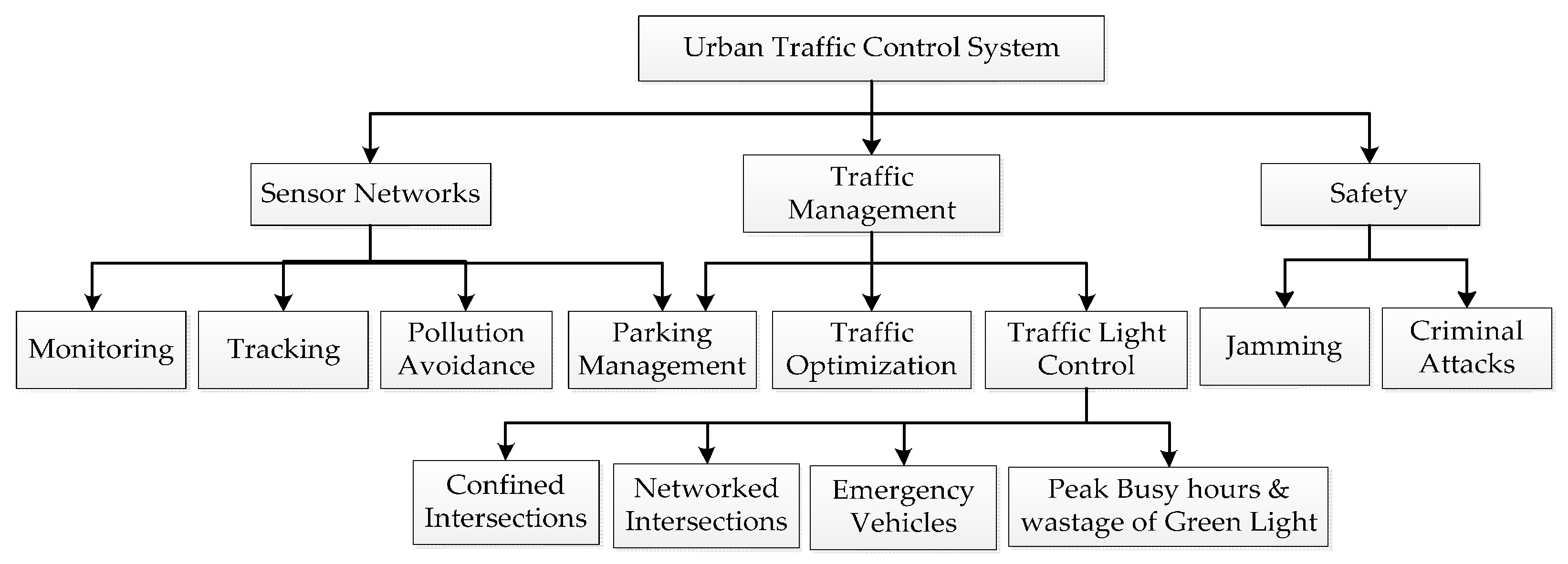
2. Key Issues in Urban Traffic Management System

- Hierarchical road infrastructures for public transportation.
- Reliable information on real-time traffic should be provided to users and traffic management systems.
- The traffic control system should be fast in taking decisions.
- The highest priority to the emergency vehicles at intersections to save lives and property.
- The system has to detect road accidents.
- A smart city traffic system should provide security.
3. Overview
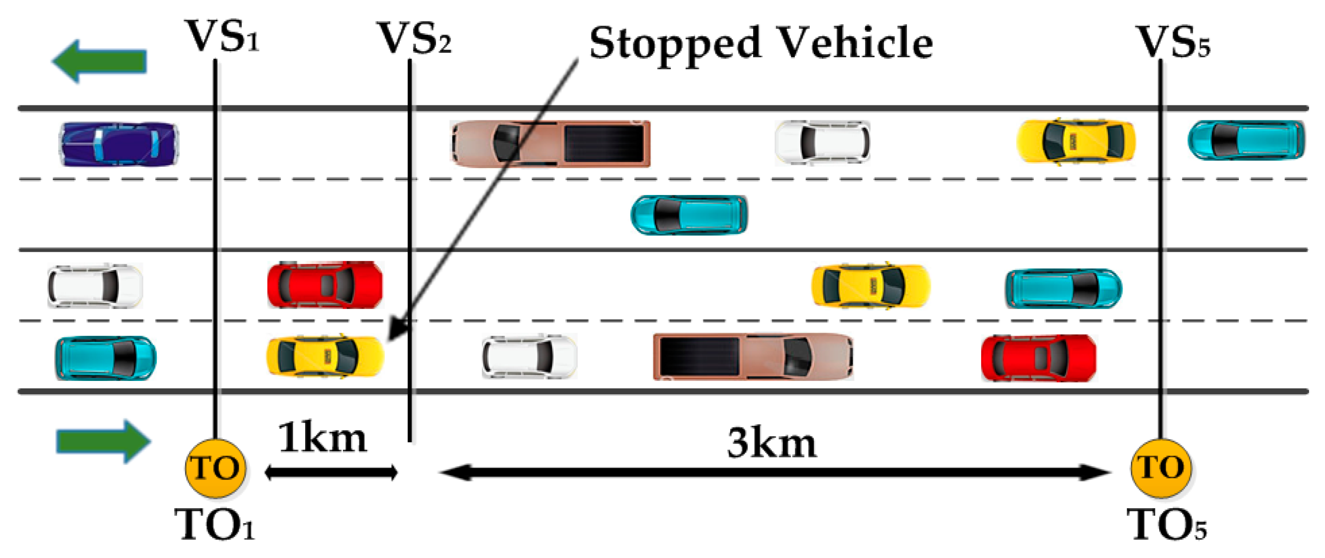
3.1. Sensing Evolution
3.2. Traffic Sensing Technologies
3.3. General Sensor Node
- A sensing module—This module acquires data.
- A processing and storage module—This module process the local data and stores it.
- A radio module—This module is for wireless data communication.
- A power module—This module is for energy supply.
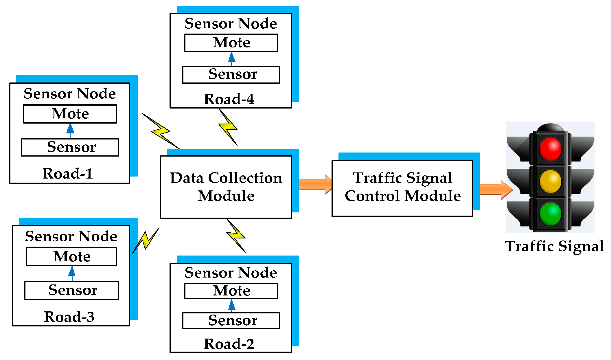
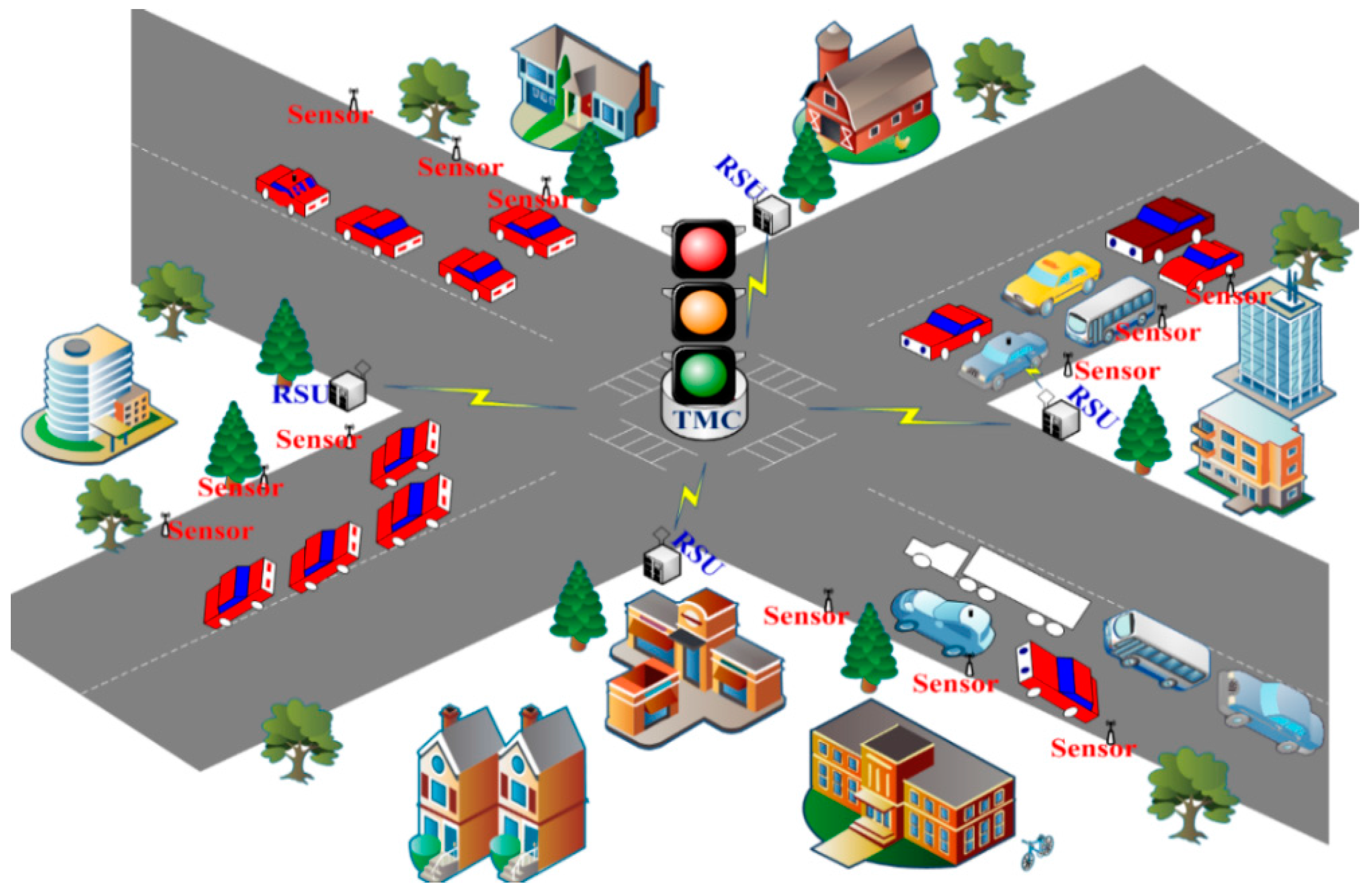
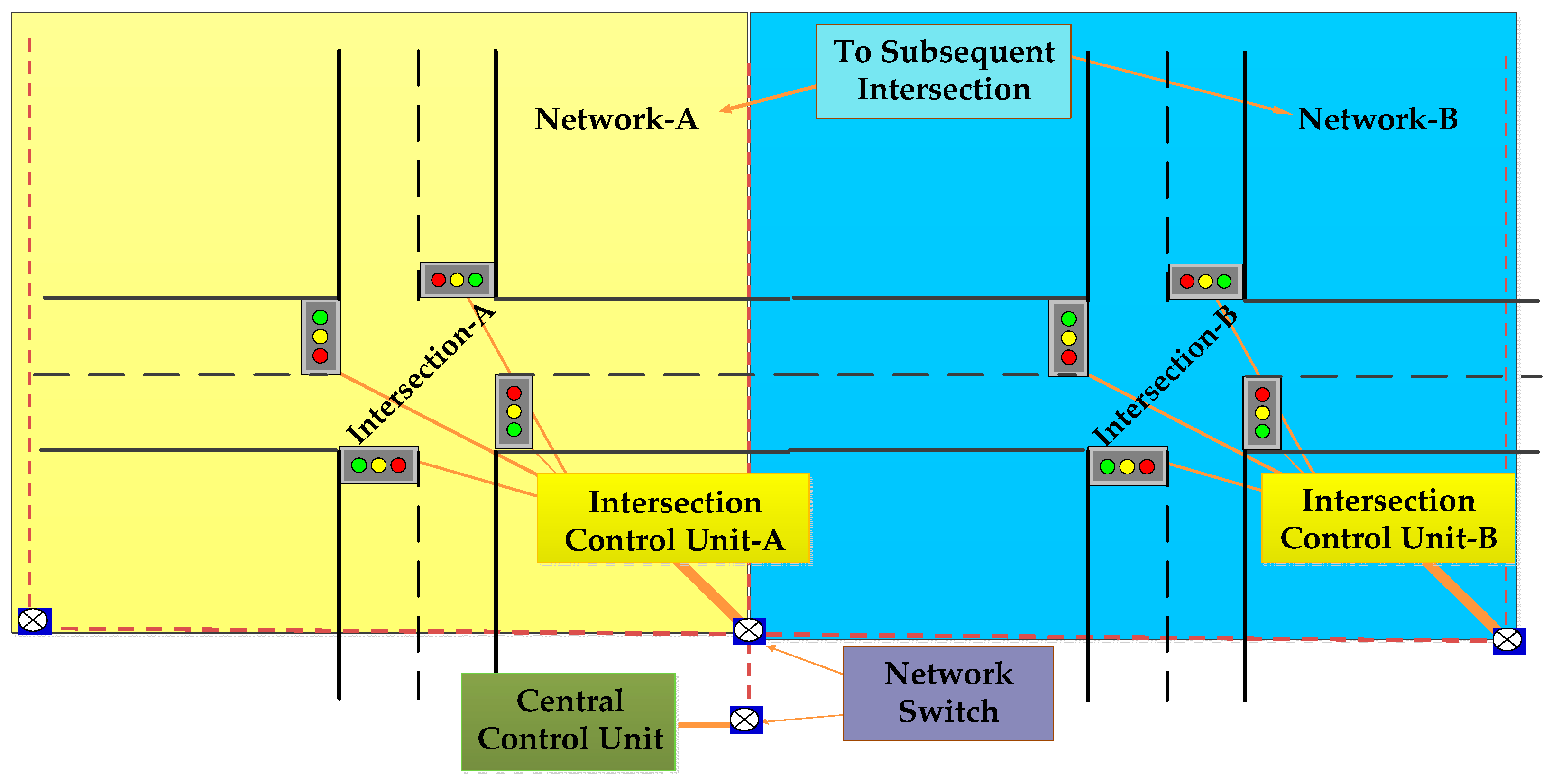
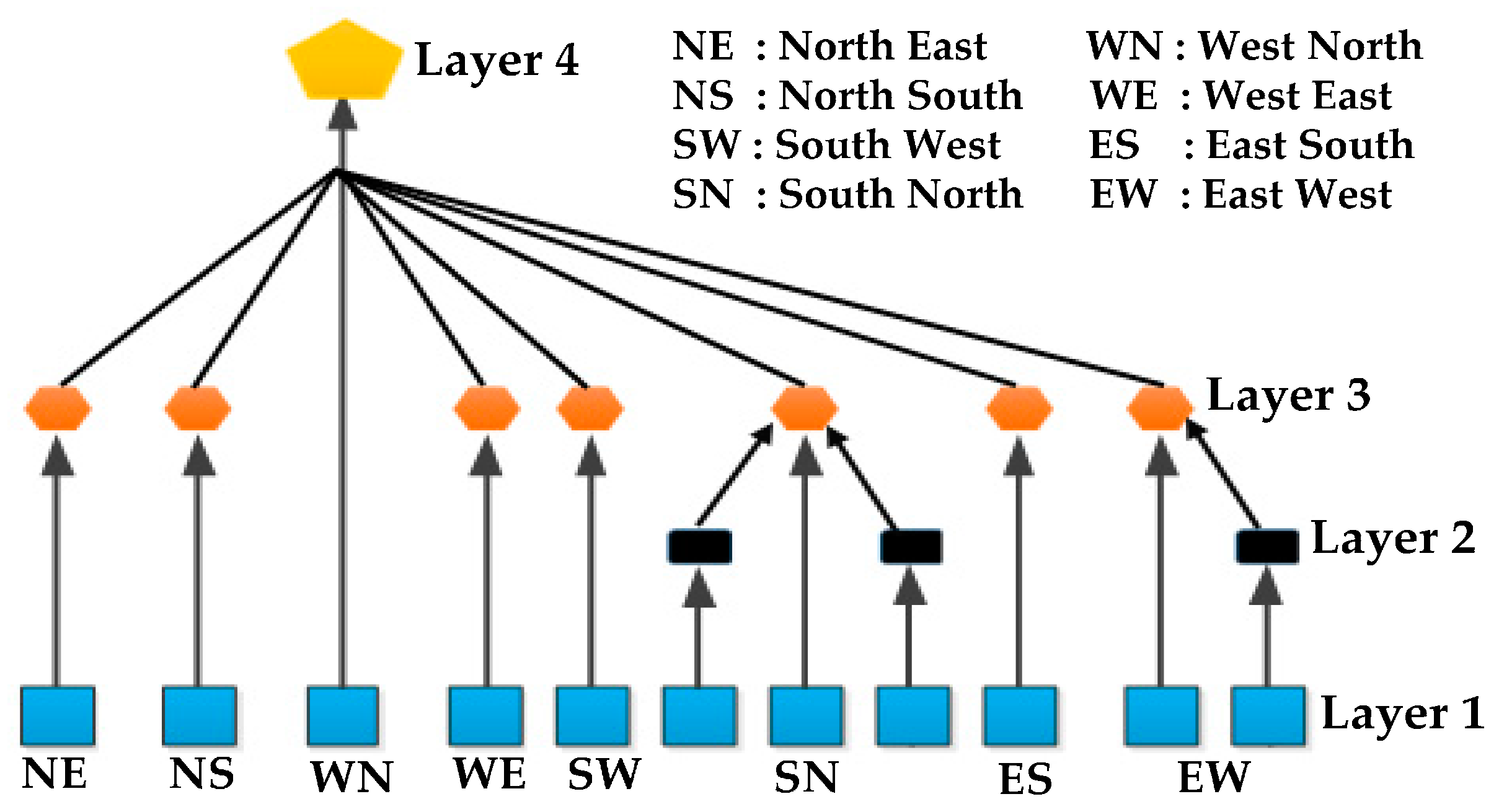
3.4. Hierarchy of Urban Traffic Management Systems

| Technology | Principles | Advantages | Disadvantages | Specific Equipment |
|---|---|---|---|---|
| Inductive loop | The inductive-loop sensor detects the vehicle or conductive metal object by sensing the loop inductance, which is dropped by inducing currents in the object. |
|
| Roadway sensors, lead-in cables, pull box and electronic unit in the control cabinet. |
| RFID (Radio-frequency identification) | RFID technology uses radio waves to give-and-take data between a reader and an electronic tag attached to a vehicle for the purpose of tracking. |
| RFID only senses equipped vehicles at a point on the road. | Antenna (transmitter and receiver), Transponder, tag reader system, and computer. |
| Microwave radar | The Microwave radar transmits signals in the recognition regions and captures the echoed signals from vehicles. The reflected signal is processed to find the speed and direction of the vehicle. |
| Continuous wave Doppler sensors are incapable of sensing immobile vehicles. | Antenna (transmitter and receiver), control unit and processor. |
| Acoustic | Acoustic sensors detect audible sounds produced by vehicular traffic and there by vehicle presence, and speed are measured. |
| Vehicle count accuracy may be affected by cold temperature. | Transducer, filters, microphones, pre amplifier, storage equipment. |
| Magnetometer | Magnetometers have sensors that sense the horizontal and vertical components of the Earth's magnetic field. |
|
| Magnetic probe detector, micro loop probes and control unit. |
| Magnetic | A magnetic sensor detects the presence of a vehicle by measuring the perturbation in the Earth's magnetic field because of a ferrous metal object. |
|
| Magnetic probe detector, micro loop probes and control unit. |
| Infrared | The infrared sensor illuminates the low powered infrared energy in the recognition regions and captures the echoed energy from the vehicles. The echoed energy is focused onto an infrared-sensitive material, which transforms the echoed and illuminated energy into electrical signals. These signals are processed and analyzed to obtain the presence of a vehicle. |
|
| Multi spectrum camera. |
| Aerial/Satellite Imaging | This technology involves the use of either manned or unmanned helicopters in the sky to capture imageries of the ground and the imageries are transmitted to a workspace for investigation. |
|
| Helicopters, Analog color PAL camera and computer. |
| Ultrasonic | An Ultrasonic sensor transmits ultrasonic waves and again collects the echoed waves from an object. It uses the time lapse between the transmitted and reflected sonic wave to identify the location of the object. |
|
| Transducers (Transmitter and Receiver), amplifier and oscillator. |
| VIP (Video image processor) | This system normally consists of a camera, processor-based workstation for analyzing the images, and software for understanding the imageries and transforming them into traffic data. |
|
| Analog color PAL camera and image processing unit. |
| Technology | Vehicle Count | Presence | Speed | Output Data | Classification | Multiple Lane, Multiple Detection Zone Data | Communication Bandwidth |
|---|---|---|---|---|---|---|---|
| Inductive loop | ✔ | ✔ | ✔ * | ✔ | ✔ & | Low to modest | |
| Magnetometer | ✔ | ✔ | ✔ * | ✔ | Low | ||
| Magnetic induction coil | ✔ | ✔ $ | ✔ * | ✔ | Low | ||
| Microwave radar | ✔ | ✔ # | ✔ | ✔ # | ✔ # | ✔ # | Moderate |
| Active infrared | ✔ | ✔ | ✔ @ | ✔ | ✔ | ✔ | Low to modest |
| Passive infrared | ✔ | ✔ | ✔ @ | ✔ | Low to modest | ||
| Ultrasonic | ✔ | ✔ | ✔ | Low | |||
| Acoustic array | ✔ | ✔ | ✔ | ✔ | ✔ ^ | Low to modest | |
| Video image processor | ✔ | ✔ | ✔ | ✔ | ✔ | ✔ | Low to high |
| Technology | Description | Standard | Frequency | Range | Throughput | Feature |
|---|---|---|---|---|---|---|
| Wi-MAX | Standard for data transmission via radio waves. | IEEE 802.16 | 2–11 GHz | <10 km | <75 Mbps | High speed and serve number of users. |
| ZigBee | Specification of a set of complex wireless communication protocols for use with low consumption digital radios, based on WPAN standard IEEE 802.15.4. | IEEE 802.15.4 | 2.4 GHz | <75 m | 250 Kbps | Mesh networks, Multiple protocol availability. |
| Bluetooth | Standard for data and voice transmission between many devices via a safe and free radio link. | IEEE 802.15.1 | 2.4 GHz | Class 1: 100 m Class 2: 15–20 m Class 3: 1 m | v. 1.2:1 Mbps v. 2.0:3 Mbps UWB: 53–480 Mbps | Low power version available. |
| UWB | UWB is merely a radio technology that can be used as part of an overall standard. | IEEE 802.15.3a | 3.1–10.6 GHz | 10 m2 m | 110 Mbps480 Mbps | Extremely fast transfer of files between servers and portable devices. |
| Wi-Fi | System of wireless data broadcast over computational webs. | IEEE 802.11a; 802.11b/g/n | 5.8 GHz 2.4 GHz | <100 m | 11/54/300 Mbps | High speed and ubiquity. |
| GSM | Typical system for communication via mobile phones including digital technology. | -- | 850/900/1800/1900 MHz | Dependent on service provider | 9.6 Kbps | Large coverage, High capacity and transmission quality. |
| GPRS | Extended GSM for packet data communication. | -- | 850/900/1800/1900 MHz | Dependent on service provider | 56–144 Kbps | High resource utilization, Short access time. |
| RFID | Uses radio waves to detect objects carrying tags. | -- | 125 KHz, 13.56 MHz, 902 to 928 MHz | Up to 3 m | 9.6–115 Kbps | Low cost. |

4. State-of-the-Art Review
4.1. Related Projects
| Project Name | Objectives | Project Sponsor | Year of completion |
|---|---|---|---|
| Hong Kong ITS project [5]. | To perform an optimal traffic management. | Hong Kong Government. | 2010 |
| A Distributed Instrument for Measuring Traffic in Short-Term Work Zones [6]. | To design, construct, and test a low-cost sensor network instrument to monitor traffic in work zones. | Research and Innovative Technology Administration, US | 2010 |
| A Multi-Dimensional Model for Vehicle Impact on Traffic Safety, Congestion, and Environment [7]. | To use technology for creating a safe, efficient and greener environment. | Research and Innovative Technology Administration, US | 2011 |
| Fast Lane: modelling and simulation of traffic flow [8]. | Prediction of the traffic flow. | Dutch traffic and transport laboratory for students, Dutch | 2013 |
| Advanced Weather Responsive Traffic Management Strategies [9]. | To perform road weather management. | Research and Innovative Technology Administration, US | 2013 |
| Adaptive Traffic Signal Control System (ACS Lite) for Wolf Road, Albany, New York [10]. | To dynamically adjust signal timing to meet current traffic demands. | New York State Department of Transportation | 2013 |
| Advanced Traveler Information System (ATIS) for Indian Cities [11]. | To provide congestion information, alternate route, travel time and alert travelers about any accident. | Department of Electronic and Information Technology (DeitY), India | 2014 |
| Agent- Based Traffic Management and Reinforcement Learning in Congested Intersections [12]. | To minimize travel time and reduce stoppage. | Research and Innovative Technology Administration, US | Start date: 2010-10-01 (In Progress) |
| A Proof-of-Concept and demonstration of a High Definition, Digital Video Surveillance and Wireless Transmission System for traffic Monitoring and Analysis [13]. | To monitor and analyze the traffic through high definition video surveillance and broadcast system. | Research and Innovative Technology Administration, US | Start date: 2009-03-20 (In progress) |
4.2. Specific Architectures, Data Collection Schemes and Routing Algorithms

| Reference | Proposed Approach | Outcome |
|---|---|---|
| Arbabi et al. [14] | Dynamic traffic monitoring system. | Collection of high quality travels time and speed. |
| Mazloumi et al. [16] | GPS based tracking system. |
|
| Bazzi et al. [17] Alexander et al. [18] | Vertical distance vector routing algorithms for timely data acquisition in VSNs. |
|
| Bruno et al. [19] | Data collection (Greedy & PDC) Schemes for urban monitoring applications. |
|
| Chao et al. [20] | RFID based intelligent traffic flow control system. |
|
| Saqib et al. [21] | Symmetric double sided two way ranging algorithm. | Position and velocity of a moving vehicle are determined with less computation. |
| Cabezas et al. [22] | WSN cross layer design approach to coordinate the transfer of packets. | Latency and jitter are improved. |
| Choi et al. [23] | Delay-optimal VSN routing algorithm (OVDF). | Improved delivery performance of data packets in VSN. |
| Friesen et al. [25] | Prototype of a cost effective Bluetooth traffic monitoring system. |
|
| Liu et al. [26] | Vehicle-logo location algorithm. | Classification of vehicles. |
| Zhou et al. [27] | User customizable data-centric routing. | Fast traffic information delivery. |
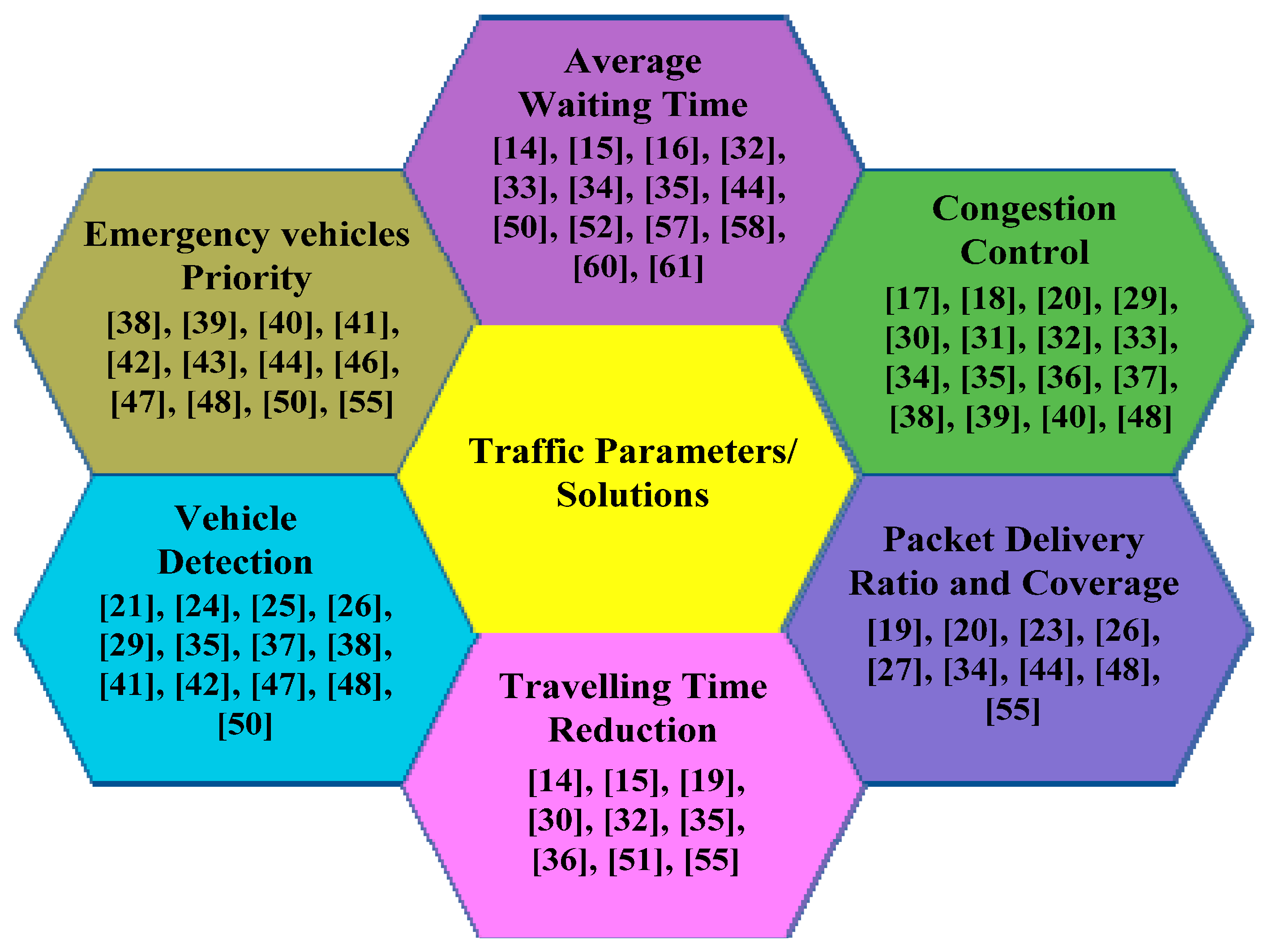
4.3. Congestion Avoidance Schemes
| Reference | Proposed Approach | Outcome |
|---|---|---|
| Du et al. [29] | Circuit patrol and Greedy patrol algorithms to improve the estimation of traffic matrix. |
|
| Knorr et al. [30] | VANET based strategies for improving traffic state estimation. |
|
| Dragoi et al. [32] | Traffic model based on the use of cars to collect traffic data and several wireless traffic lights. |
|
| Ahmad et al. [33] | A test bed for evaluation of traffic signal control algorithms. | Accurate measurement of execution times. |
| Skordylis et al. [34] | Data spreading algorithms (D-Greedy, D-min cost) for optimizing the data delivery and the data acquisition. |
|
| Abishek et al. [35] | Adaptive traffic flow algorithm. |
|
| Eren et al. [36] | ZigBee based wireless system to assist traffic flow on urban roads. |
|
| Laisheng et al. [37] | Traffic random early detection (TRED) algorithm for real-time scheduling of traffic. | Reduce Congestion. |
4.4. Priority-Based Traffic Management Schemes

| Reference | Proposed Approach | Outcome |
|---|---|---|
| Rajeshwari et al. [38] Sireesha et al. [39] Shruthi et al. [40] Hussian et al. [41] Nabeel et.al. [42] | Implemented traffic control system. |
|
| Chakraborty et al. [43] | Real-time optimized traffic management algorithm. | Effective management of high prioritized vehicles. |
| Farheena et al. [44] | Traffic light control system and congestion avoidance systems are proposed. |
|
| Zhou et al. [45] Tao et al. [46] | SIP/ZIGBEE based architecture for distributed traffic monitoring. | Remote communications and control operations of ITS distribution nodes are unified and simplified. |
| Bottero et al. [47] | Magnetic sensor based traffic monitoring in logistic centers. |
|
| Brahmi et al. [48] | Enhanced back-off section scheme for IEEE 802.15.4. |
|
4.5. Average Waiting Time Reduction Schemes


| Reference | Proposed Approach | Outcome |
|---|---|---|
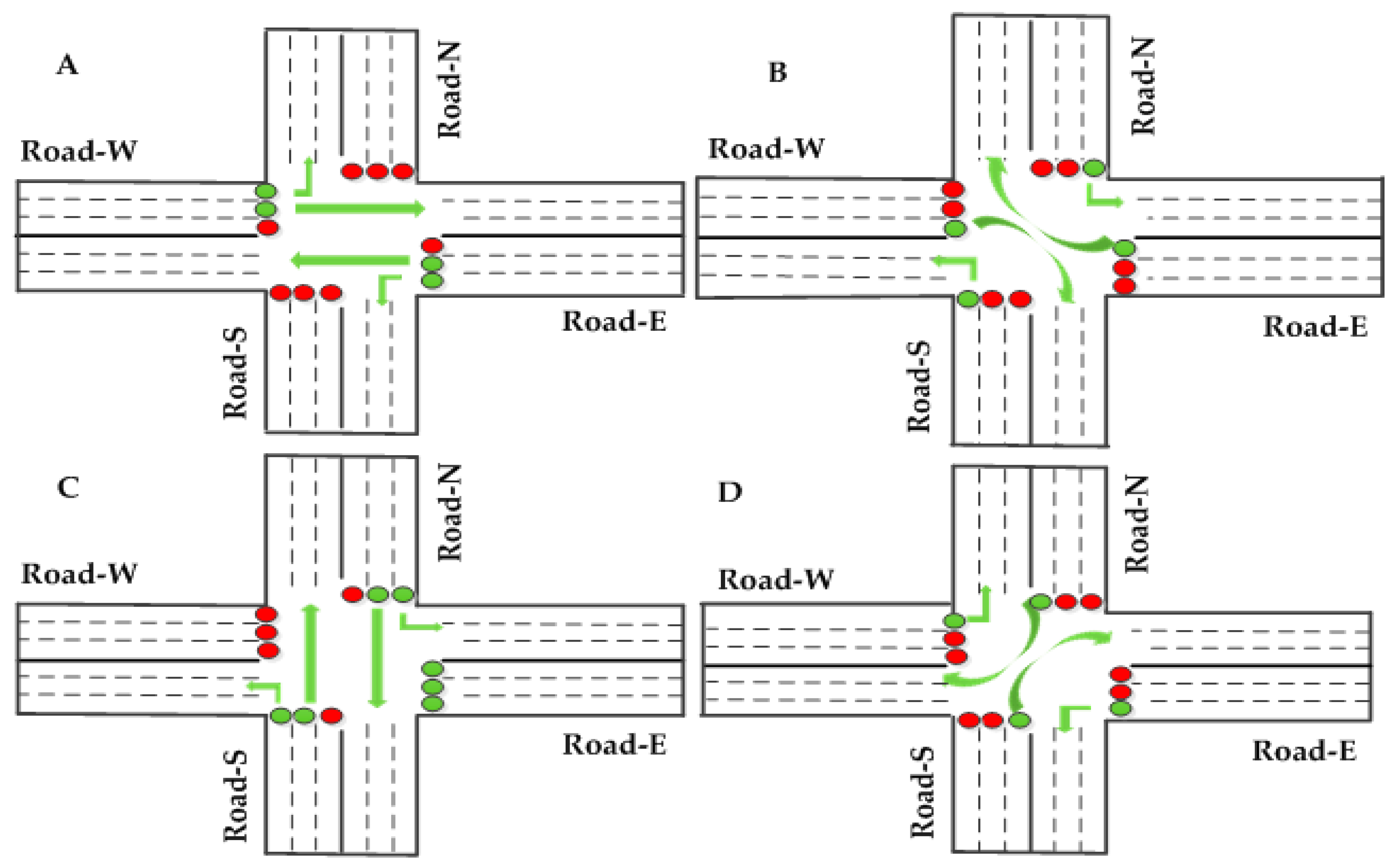
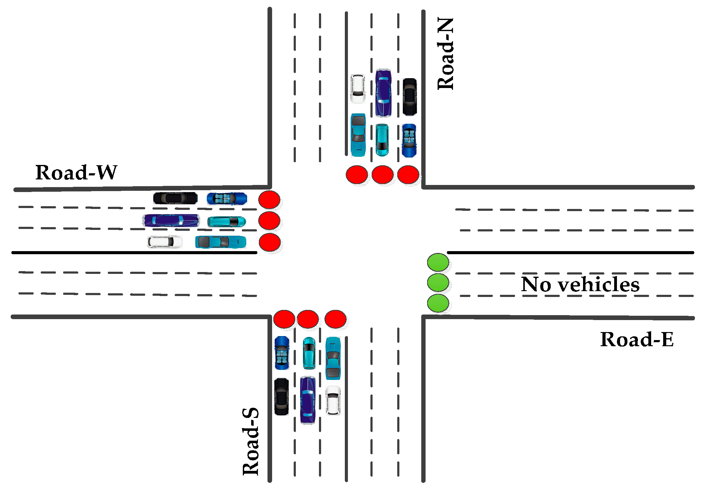
| Srivastava et al. [50] | Adaptive traffic flow algorithms Maximum intersection utilizations (MIU). Empty lane with green light (ELWGL). | The average waiting time: Orthodox policy: 26.7 cycles. MIU: 22.6 cycles. ELWGL: 6.5 cycles. |
| Zhou et al. [51] | Adaptive traffic light control algorithm. |
|
| Bhuvaneswari et al. [52] Zhou et al. [53] | Adaptive traffic signal flow control system. |
|
| Bharadwaj et al. [55] | Vehicle count calculation and single toggle algorithm. |
|
| Faye et al. [57] | Distributed algorithm to control traffic lights in urban areas. |
|
| Al-Nasser et al. [58] Collotta et al. [59] | Smart traffic signal control algorithms. |
|
| Collotta et al. [61] Wu et al. [62] | Dynamic traffic light control system based on WSNs and FUZZI logic controllers. |
|
| Gomez et al. [63] | Traffic light state estimation using hidden Markov models. | Obtained 90.55% of accuracy in the detection of traffic light state. |

5. Challenges
6. Conclusions and Future Work
Author Contributions
Conflicts of Interest
References
- Litman, T. Congestion Costing Critique Critical Evaluation of the Urban Mobility 2014 Report; Victoria Transport Policy Institute: Victoria, BC, Canada, 2014. [Google Scholar]
- 2013 Status of the Nation’s Highways, Bridges, and Transit: Conditions and Performance; US Federal Highway Administration Report; US Department of Transportation: Washington, DC, USA, 2013.
- Padmavathi, G.; Shanmugapriya, D.; Kalaivani, M. A study on vehicle detection and tracking using wireless sensor networks. Wirel. Sens. Netw. 2010, 2, 173–185. [Google Scholar] [CrossRef]
- Albaladejo, C.; Sánchez, P.; Iborra, A.; Soto, F.; López, J.A.; Torres, R. Wireless Sensor Networks for Oceanographic Monitoring: A Systematic Review. Sens. 2010, 10, 6948–6968. [Google Scholar] [CrossRef] [PubMed]
- Hong Kong Government. Intelligent Transport System (ITS). Available online: http://www.roadtraffic-technology.com/projects/hong-kong/ (accessed on 14 April 2015).
- Sridhar, N. A Distributed Instrument for Measuring Traffic in Short-Term Work Zones. Available online: http://ntlsearch.bts.gov/researchhub/search.do?managed=&stgrpid=&range=&so=asc&q=traffic+management+projects&p=15&sb=ti_sort&manageableMode=&psize=50&pid=&mode=&size=1 (accessed on 14 April 2015).
- Al-Holous, N.; Syed Masud, M.; Mohammad, U. A Multi-Dimensional Model for Vehicle Impact on Traffic Safety, Congestion, and Environment. Available online: http://mioh-utc.udmercy.edu/research/ts-45/index.htm (accessed on 14 April 2015).
- Dutch Traffic and Transport Laboratory. Fast Lane: Modelling and Simulation of Traffic Flow. Available online: http://www.its-edulab.nl/projects/fastlane%3A-modelling-and-simulation-traffic-flow (accessed on 14 April 2015).
- Alfelor, R. Advanced Weather Responsive Traffic Management Strategies. Available online: http://ntlsearch.bts.gov/researchhub/search.do?managed=&stgrpid=&range=&so=asc&q=traffic+management+projects&p=158&sb=ti_sort&manageableMode=&psize=50&pid=&mode=&size=1 (accessed on 14 April 2015).
- Ban, X.J.; Wang, C.; Kanga, C. Adaptive Traffic Signal Control System (ACS Lite) for Wolf Road, Albany, New York State Department of Transportation (NYSDOT), University Transportation Research Center, Region 2 (UTRC2). Available online: http://ntlsearch.bts.gov/researchhub/search.do?managed=&stgrpid=&range=&so=asc&q=traffic+monitoring&p=68&sb=ti_sort&manageableMode=&psize=50&pid=&mode&size=1 (accessed on 14 April 2015).
- Sivanandam, R.; Lelitha Devi, V.; Ravi, V.; Krishna Kumar, S. Advanced Traveller Information System (ATIS) for Indian Cities. Available online: https://coeut.iitm.ac.in/umcsp/pdfweb/v2iitm_ATIS%20For%20indian%20cities_v2.pdf (accessed on 14 April 2015).
- Benekohal, R.F. Agent-Based Traffic Management and Reinforcement Learning in Congested Intersections. Available online: http://ntlsearch.bts.gov/researchhub/search.do?managed=&stgrpid=&range=&so=asc&q=traffic+monitoring&p=107&sb=ti_sort&manageableMode=&psize=50&pid=&mode=&size=1 (accessed on 14 April 2015).
- Christopher, D. A Proof-of-Concept and Demonstration of a High Definition, Digital Video Surveillance and Wireless Transmission System for Traffic Monitoring and Analysis. Available online: http://ntlsearch.bts.gov/researchhub/search.do?managed=&stgrpid=&range=&so=asc&q=traffic+management+projects&p=52&sb=ti_sort&manageableMode=&psize=50&pid=&mode=&size=1 (accessed on 14 April 2015).
- Arbabi, H.; Weigle, C.M. Using DTMon to monitor transient flow traffic. In Proceedings of the IEEE Vehicular Networking Conference (VNC), Jersey City, NJ, USA, 13–15 December 2010; pp. 110–117.
- Arbabi, H.; Weigle, C.M. Monitoring free flow traffic using vehicular networks. In Proceedings of the IEEE Consumer Communications and Networking Conference (CCNC), Las Vegas, NV, USA, 9–12 January 2011; pp. 272–276.
- Mazloumi, E.; Asce, M.S.; Currie, G.; Rose, G. Using GPS data to gain insight into public transport travel time variability. J. Transp. Eng. 2010, 136, 623–631. [Google Scholar] [CrossRef]
- Bazzi, A.; Masini, M.B.; Zanella, A.; Pasoloni, G. Vehicle-to-vehicle and vehicle-to-roadside multi-hope communications for vehicular sensor networks: Simulations and field trial. In Proceedings of the IEEE International Conference on Communication workshops (ICC), Budapest, Hungary, 9–13 June 2013; pp. 515–520.
- Alexander, P.; Haley, D.; Grant, A. Co-operative intelligent transport system: 5.9-GHz field trials. IEEE Proc. 2001, 99, 1213–1235. [Google Scholar]
- Bruno, R.; Nurchis, M. Robust and efficient data collection schemes for vehicular multimedia sensor networks. In Proceedings of the IEEE 14th International Symposium and Workshops on World of Wireless, Mobile and Multimedia Networks (WoWMoM), Madrid, Spain, 4–7 June 2013; pp. 1–10.
- Chao, K.H.; Chen, P. An intelligent traffic flow control system based on radio frequency identification and wireless sensor networks. Int. J. Distrib. Sens. Netw. 2014, 2014, 1–10. [Google Scholar]
- Saqib, M.; Lee, C. Traffic control system using wireless sensor network. In Proceedings of the 12th IEEE International Conference on Advanced Communication Technology (ICACT), Phoenix Park, Korea, 7–10 February 2010; pp. 352–357.
- Cabezas, C.A.; Medina, G.R.; Pea, T.M.N.; Labrador, A.M. Low energy and low latency in wireless sensor networks. In Proceedings of the IEEE International Conference on Communications (ICC-09), Dresden, Germany, 14–18 June 2009; pp. 1–5.
- Choi, O.; Kim, S.; Jeong, J.; Lee, W.H.; Chong, S. Delay-optimal data forwarding in vehicular sensor networks. In Proceedings of the IEEE 11th International Symposium on Modeling and Optimization in Mobile, Ad Hoc and Wireless Networks (WiOpt), Tsukuba Science City, Japan, 13–17 May 2013; pp. 532–539.
- Lee, U.; Magistretti, E.; Gerla, M.; Bellavista, P.; Corradi, A. Dissemination and harvesting of urban data using vehicular sensing platforms. IEEE Trans. Veh. Technol. 2009, 58, 882–901. [Google Scholar]
- Friesen, M.; Jacob, R.; Grestoni, P.; Mailey, T.; Friesen, R.M.; McLeod, D.R. Vehicular traffic monitoring using Bluetooth scanning over a wireless sensor networks. Can. J. Electr. Comput. Eng. 2014, 37, 135–144. [Google Scholar] [CrossRef]
- Liu, Y.; Li, S. A vehicle-logo location approach based on edge detection and projection. In Proceedings of the IEEE International Conference on Vehicular Electronics and Safety (ICVES), Beijing, China, 10–12 July 2011; pp. 165–168.
- Zhou, J.; Member, S.; Chen, C.; Chen, L.; Zhao, W. A user-customizable urban traffic information collection method based on wireless sensor networks. IEEE Trans. Intell. Transp. Syst. 2013, 14, 1–10. [Google Scholar] [CrossRef]
- Ahmad, F.; Basit, A.; Ahmad, H.; Mahmud, A.S.; Khan, M.G.; Yousaf, Z.F. Feasibility of deploying wireless sensor based roadside solutions for intelligent transportation systems. In Proceedings of the IEEE International Conference on Connected Vehicles and Expo (ICCVE), Las Vegas, NV, USA, 2–6 December 2013; pp. 320–326.
- Du, R.; Chen, C.; Yang, B.; Lu, N.; Guan, X.; Shen, X. Effective urban traffic monitoring by vehicular sensor networks. IEEE Trans. Veh. Technol. 2015, 64, 273–286. [Google Scholar] [CrossRef]
- Knorr, F.; Baselt, D.; Schreckenberg, M.; Mauve, M. Reducing traffic jams via VANETs. IEEE Trans. Veh. Technol. 2012, 61, 3490–3498. [Google Scholar] [CrossRef]
- Wang, Y.; Wu, F.; Tseng, Y. Mobility management algorithms and applications for mobile sensor networks. Wirel. Commun. Mobile Comput. 2012, 12, 7–21. [Google Scholar] [CrossRef]
- Dragoi, V.; Dobre, C. A model for traffic control in urban environments. In Proceedings of the 7th IEEE International Wireless Communications and Mobile Computing Conference (IWCMC), Istanbul, Turkey, 4–8 July 2011; pp. 2139–2144.
- Ahmad, F.; Khan, I.; Mahmud, A.S.; Khan, M.G.; Yousaf, Z.F. Real time evaluation of shortest remaining processing time based schedulers for traffic congestion control using wireless sensor networks. In Proceedings of the IEEE International Conference on Connected Vehicles and Expo (ICCVE), Las Vegas, NV, USA, 2–6 December 2013; pp. 381–387.
- Skordylis, A.; Trigoni, N. Efficient data propagation in traffic-monitoring vehicular networks. IEEE Trans. Intell. Transp. Syst. 2011, 12, 680–694. [Google Scholar] [CrossRef]
- Abishek, C.; Kumar, M.; Kumar, P. City traffic congestion control in India scenario using wireless sensor network. In Proceedings of the Fifth IEEE Conference on Wireless Communication and Sensor Networks (WCSN), Allahabad, India, 15–19 December 2009; pp. 1–6.
- Eren, H.; Pakka, M.H.; AlGhamdi, S.A.; Yue, Y. Instrumentation for safe vehicular flow in intelligent traffic control systems using wireless networks. In Proceedings of the IEEE International conference on Instrumentation and Measurement Technology (I2MTC), Minneapolis, MN, USA, 6–9 May 2013; pp. 1301–1305.
- Xiao, L.; Peng, X.; Wang, Z.; Xu, B.; Hong, B. Research on traffic monitoring network and its traffic flow forecast and congestion control model based on wireless sensor networks. In Proceedings of the IEEE International conference on Measuring Technology and Mechatronics Automation (ICMTMA), Zhangjiajie, China, 11–12 April 2009; pp. 142–147.
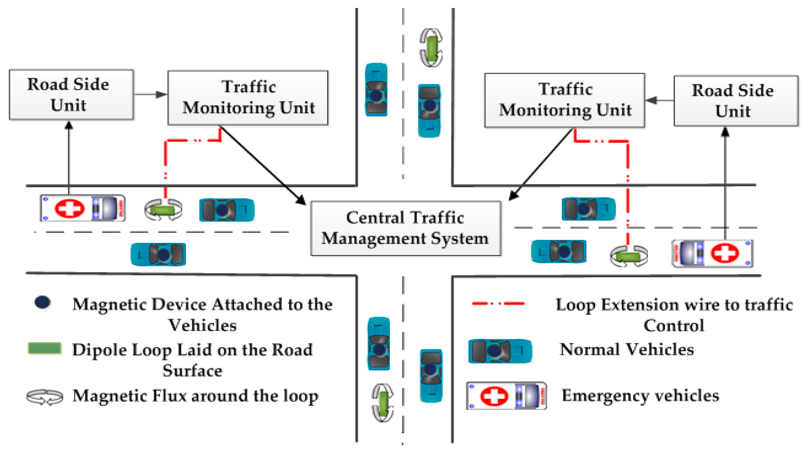
- Rajeshwari, S.; Santhoshs, H.; Varaprasad, G. Implementing intelligent traffic control system for congestion control, ambulance clearance and stolen vehicle detection. IEEE Sens. J. 2015, 15, 1109–1113. [Google Scholar]
- Sireesha, E.; Rakesh, D. Intelligent traffic light system to prioritized emergency purpose vehicles based on wireless sensor network. Int. J. Res. Stud. Sci. Eng. Technol. 2014, 1, 24–27. [Google Scholar]
- Shruthi, R.K.; Vinodha, K. Priority based traffic light controller. Int. J. Electron. Signal Syst. 2014, 1, 58–61. [Google Scholar]
- Hussian, R.; Sandhy, S.; Vinita, S.; Sandhya, S. WSN applications: Automated intelligent traffic control system using sensors. Int. J. Soft Comput. Eng. 2013, 3, 77–81. [Google Scholar]
- Nabeel, M.M.; EI-Dien, F.M.; EI-Kader, A.S. Intelligent vehicle recognition based on wireless sensor network. Int. J. Comput. Sci. Issues 2013, 10, 164–174. [Google Scholar]
- Chakraborty, S.P.; Nair, P.; RajSinha, P.; Ishan Kumar, B. Real time optimized traffic management algorithm. Int. J. Comput. Sci. Inf. Technol. 2014, 6, 119–136. [Google Scholar] [CrossRef]
- Farheena, S.; Chandak, B.M. An approach towards traffic management system using density calculation and emergency vehicle alert. In Proceedings of the International Conference on Advances in Engineering and Technology (ICAET-2014), Singapore, 29–30 March 2014; pp. 24–27.
- Zhou, J.; Li, C.; Zhang, Z. Intelligent transportation system based on SIP/ZigBee architecture. In Proceedings of the IEEE International Conference on Image Analysis and Signal Processing (IASP), Wuhan, China, 21–23 October 2011; pp. 405–409.
- Tao, H.; Liu, W.; Ma, S. Intelligent transportation system for wireless sensor networks based on ZigBee. In Proceedings of the International Conference on Computer and Communication Technologies in Agriculture Engineering, Changdu, China, 12–13 June 2010; pp. 396–399.
- Bottero, M.; Chiara, D.B.; Deflorio, P.F. Wireless sensor networks for traffic monitoring in a logistic center. Transp. Res. Part C 2013, 26, 99–124. [Google Scholar] [CrossRef]
- Brahmi, H.; Djahel, S.; Murphy, J. Improving emergency messages transmission delay in road monitoring based WSNs. In Proceedings of the IEEE 6th Joint IFIP Conference on Wireless and Mobile Networks (WMNC), Dubai, United Arab Emirates, 23–25 April 2013; pp. 1–8.
- Fan, K.; Chen, J.; Cao, Q. Design and research on traffic of wireless sensor network based on LabVIEW. In Proceedings of the 2nd International Symposium on Computer, Communication, Control and Automation (3CA 2013), Singapore, 1–2 December 2013; pp. 6–9.
- Srivastava, J.R.; Sudarshan, T.S.B. Intelligent Traffic management with wireless sensor networks. In Proceedings of the IEEE ASC International Conference on Computer System and Applications (AICCSA), Fez/Ifrane, Morocco, 27–30 May 2013; pp. 1–4.
- Zhou, B.; Cao, J.; Zeng, X.; Wu, H. Adaptive traffic light control in wireless sensor networks-based intelligent transportation system. In Proceedings of the IEEE 72nd Vehicular Technology Conference (VTC 2010-Fall), Ottawa, ON, Canada, 6–9 September 2010; pp. 1–5.
- Bhuvaneswari, V.T.P.; Arunraj, V.G.; Balaji, R.; Kanagasabai, S. Adaptive traffic signal flow control using wireless sensor networks. In Proceedings of the IEEE Fourth International Conference on Computational Intelligence and Communication Networks (CICN), Mathura, Uttar Pradesh, India, 3–5 November 2012; pp. 85–89.
- Zhou, B.; Cao, J.; Wu, H. Adaptive traffic light control of multiple intersections in WSN-based ITS. In Proceedings of the IEEE 73rd Vehicular Technology Conference (VTC Spring), Yokohama, Japan, 15–18 May 2011; pp. 1–5.
- Yousef, M.K.; Al-Karaki, N.J.; Shatnawi, M.A. Intelligent traffic light flow control system using wireless sensor networks. J. Inf. Sci. Eng. 2010, 26, 753–768. [Google Scholar]
- Bharadwaj, R.; Deepak, J.; Baranitharam, M.; Vaidehi, V. Efficient dynamic traffic control system using wireless sensor networks. In Proceedings of the IEEE International Conference on Recent Trends in Information Technology (ICRTIT), Chrompet, Chennai, India, 25–27 July 2013; pp. 668–673.
- Bhattacharya, R.; Floerkemeier, C.; Sarma, S. Towards tag antenna based sensing-an RFID displacement sensors. In Proceedings of the IEEE International Conference on RFID, Arlington, TX, USA, 27–28 April 2009; pp. 95–102.
- Faye, S.; Chaudet, C.; Demeure, I. A distributed algorithm for multiple intersections adaptive traffic lights control using a wireless sensor networks. In Proceedings of the First Workshop on Urban Networking, Nice, France, 10–13 December 2012; pp. 13–18.
- Al-Nasser, A.F.; Rowaihy, H. Simulation of dynamic traffic control system based on wireless sensor networks. In Proceedings of the IEEE Symposium on Computers and Informatics (ISCI), TBD, Kuala Lumpur, Malaysia, 20–23 March 2011; pp. 40–45.
- Collotta, M.; Pau, G.; Scata, G.; Campisi, T. A dynamic traffic light management system based on wireless sensor networks for the reduction of the red-light running phenomenon. Transp. Telecommun. J. 2014, 15, 1–11. [Google Scholar] [CrossRef]
- Olatunbosun, P. Wireless sensor networks for intelligent transport systems. In Proceedings of the 12th Research Seminar Series Workshop, Bradford, UK, 10 April 2013.
- Collotta, M.; Bello, L.L.; Pau, G. A novel approach for dynamic traffic light management based on wireless sensor networks and multiple fuzzy logic controllers. Expert Syst. Appl. 2015, 42, 5403–5415. [Google Scholar] [CrossRef]
- Wu, L.; Zhang, X.; Shi, Z. An intelligent fuzzy control for crossroads traffic light. In Proceedings of the Second WRI Global Congress on Intelligent Systems (GCIS), Wuhan, China, 16–17 December 2010; Volume 3, pp. 28–32.
- Gomez, A.; Alencar, F.; Prado, P.; Osorio, F.; Wolf, D. Traffic lights detection and state estimation using hidden Markova models. In Proceedings of the IEEE Symposium on Intelligent Vehicles, Dearborn, MI, USA, 8–11 June 2014; pp. 750–755.
© 2016 by the authors; licensee MDPI, Basel, Switzerland. This article is an open access article distributed under the terms and conditions of the Creative Commons by Attribution (CC-BY) license (http://creativecommons.org/licenses/by/4.0/).
Share and Cite
Nellore, K.; Hancke, G.P. A Survey on Urban Traffic Management System Using Wireless Sensor Networks. Sensors 2016, 16, 157. https://doi.org/10.3390/s16020157
Nellore K, Hancke GP. A Survey on Urban Traffic Management System Using Wireless Sensor Networks. Sensors. 2016; 16(2):157. https://doi.org/10.3390/s16020157
Chicago/Turabian StyleNellore, Kapileswar, and Gerhard P. Hancke. 2016. "A Survey on Urban Traffic Management System Using Wireless Sensor Networks" Sensors 16, no. 2: 157. https://doi.org/10.3390/s16020157
APA StyleNellore, K., & Hancke, G. P. (2016). A Survey on Urban Traffic Management System Using Wireless Sensor Networks. Sensors, 16(2), 157. https://doi.org/10.3390/s16020157