
An Analysis of the Influence of Flight Parameters in the Generation of Unmanned Aerial Vehicle (UAV) Orthomosaicks to Survey Archaeological Areas

 , and
, and
Abstract
:1. Introduction
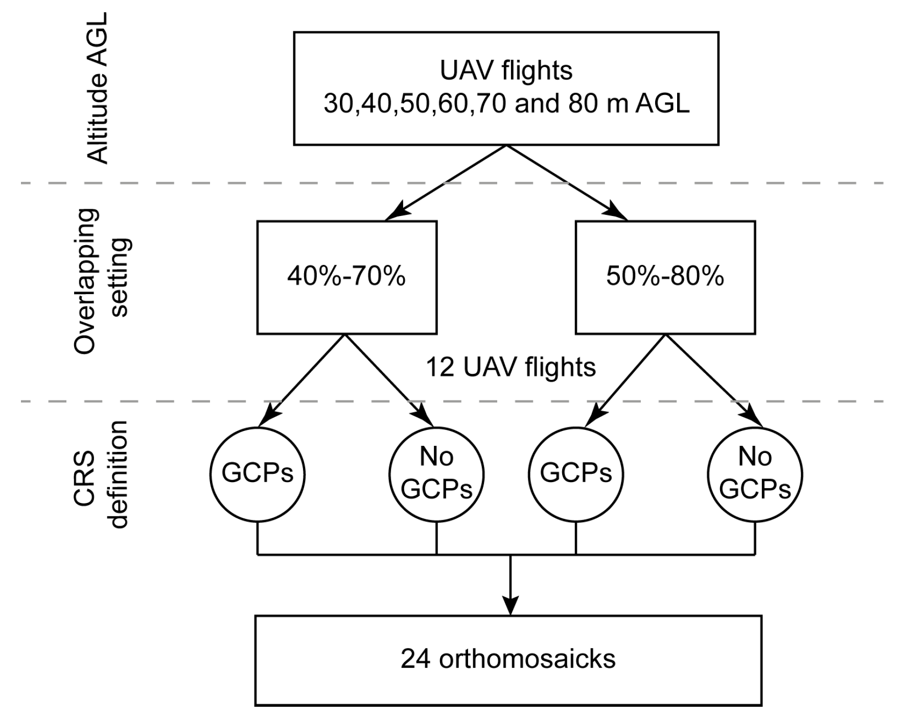
2. Materials and Methods
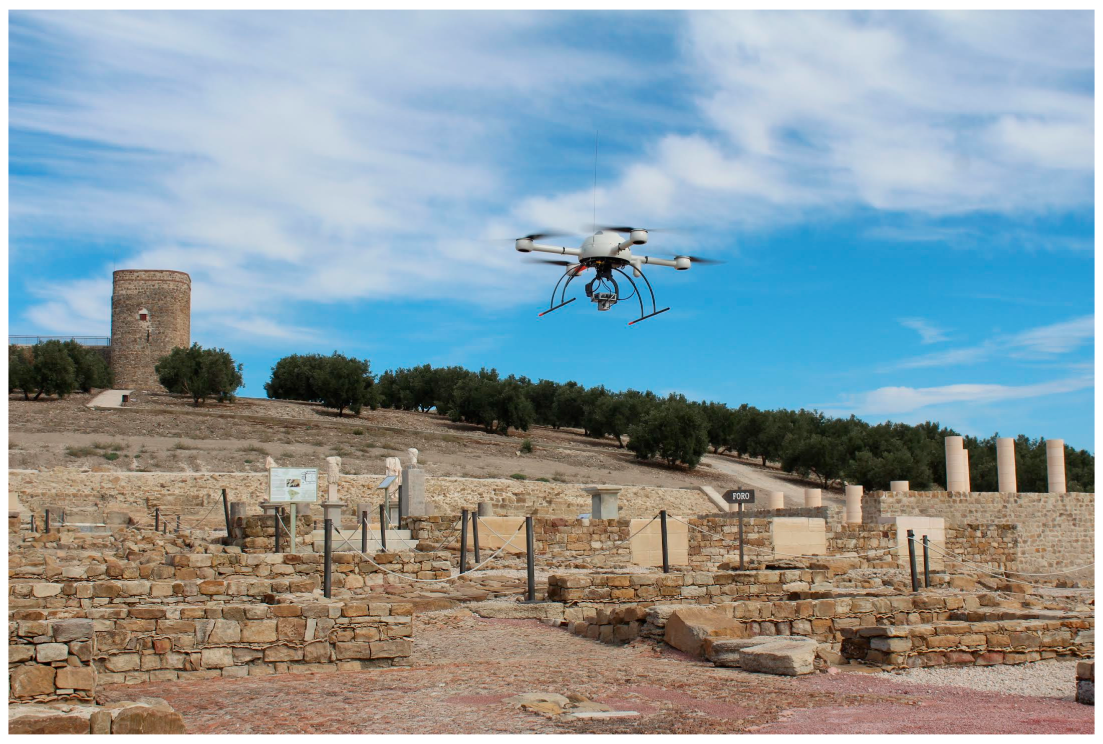
2.1. UAV and Sensor Description
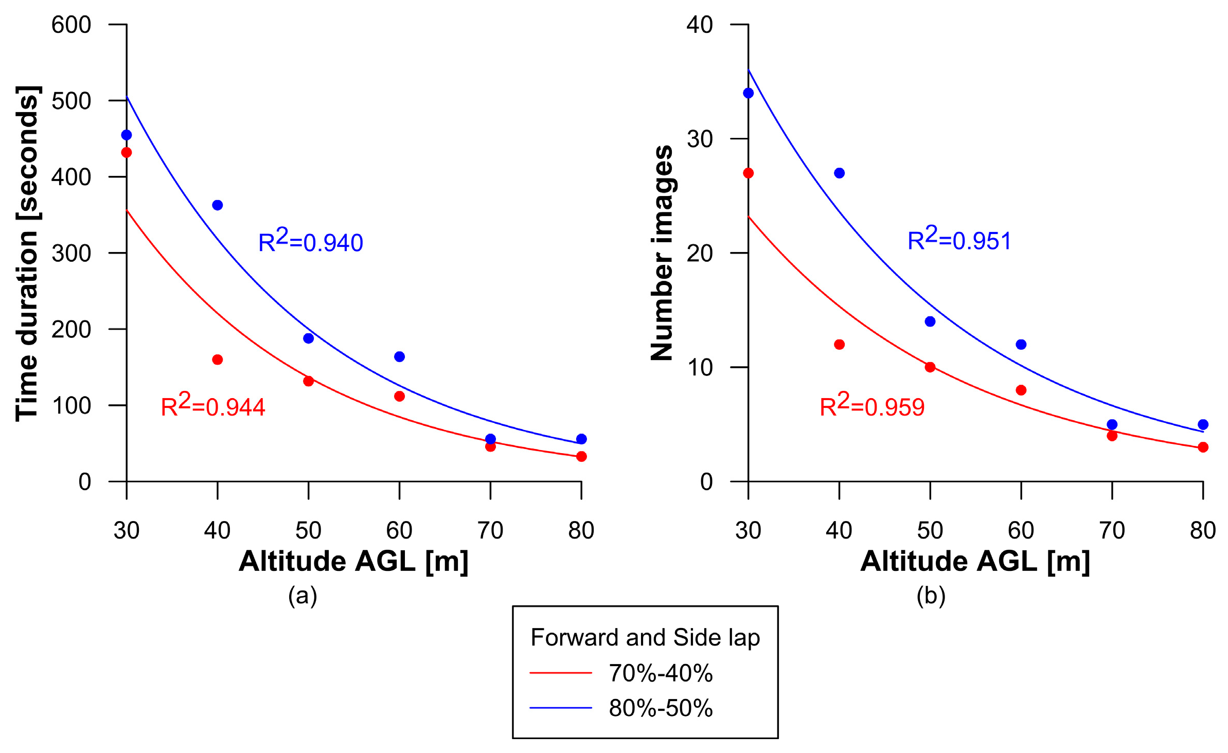
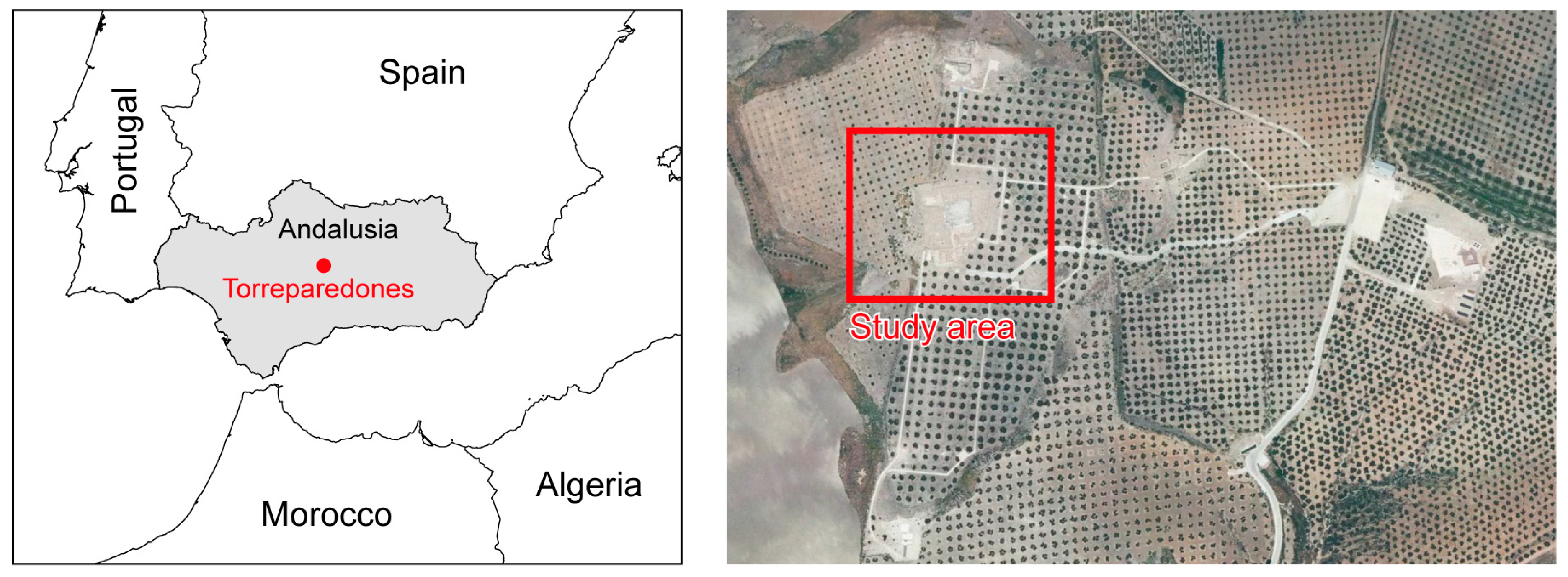
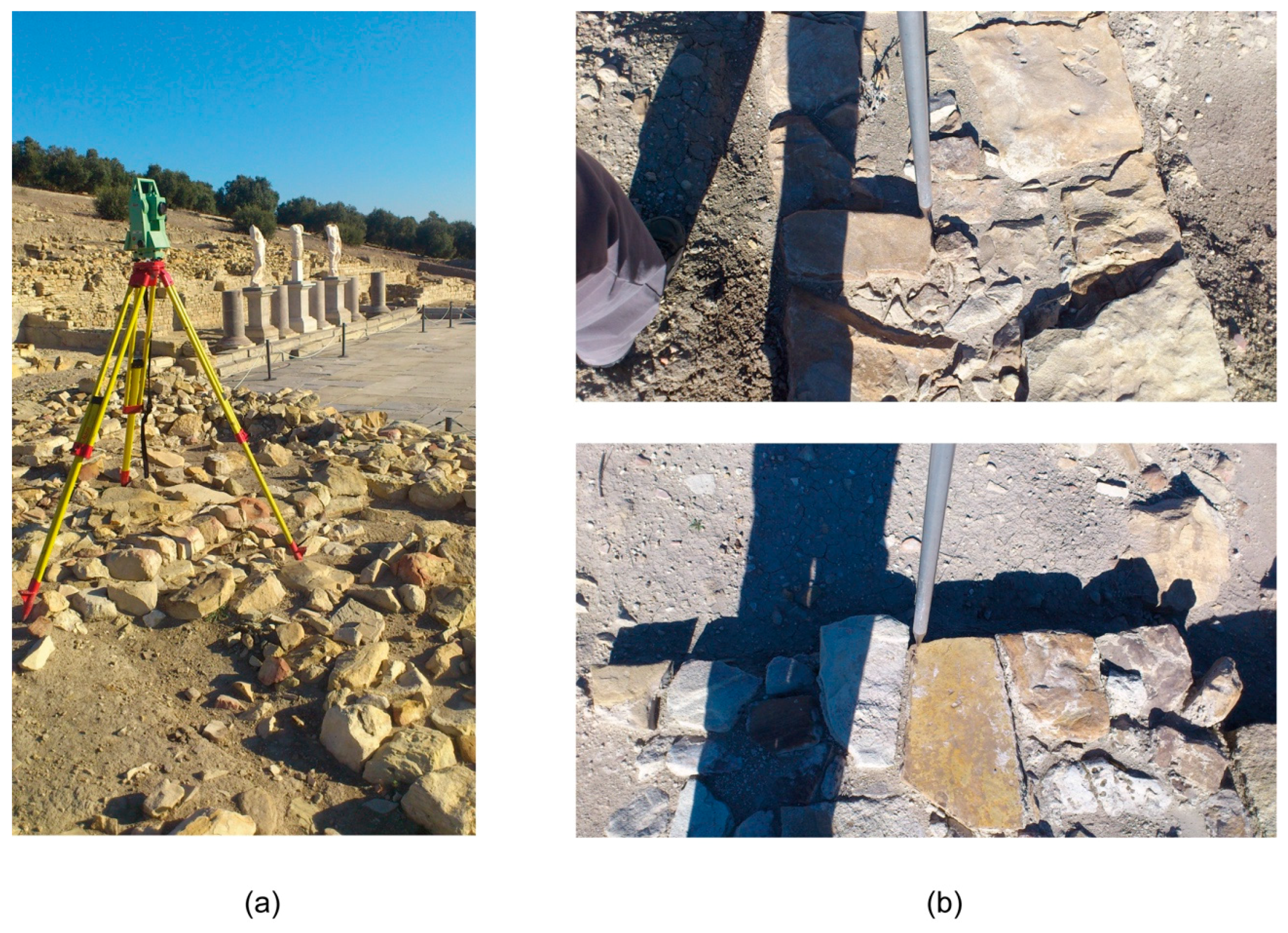
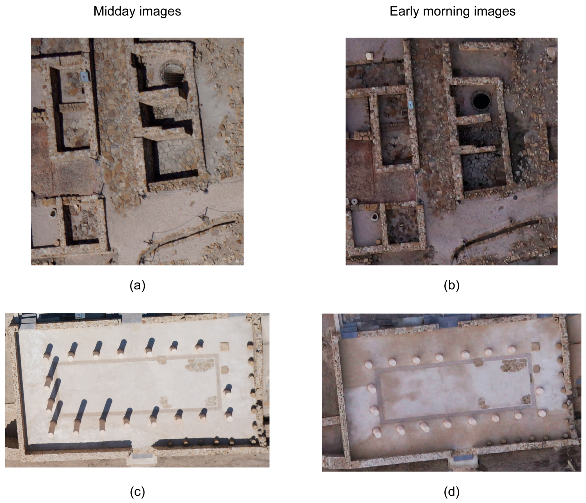
2.2. Study Site and UAV Flights
2.3. Photogrammetric Processing
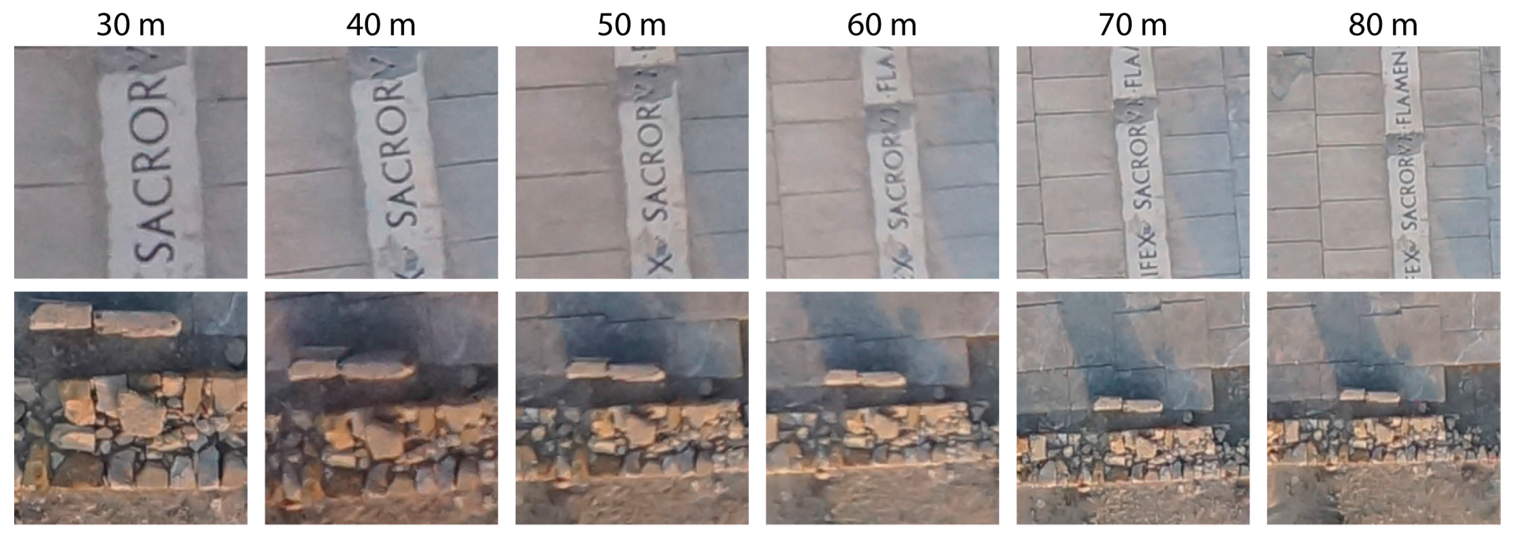
2.4. Assessment of Spatial Quality
3. Results
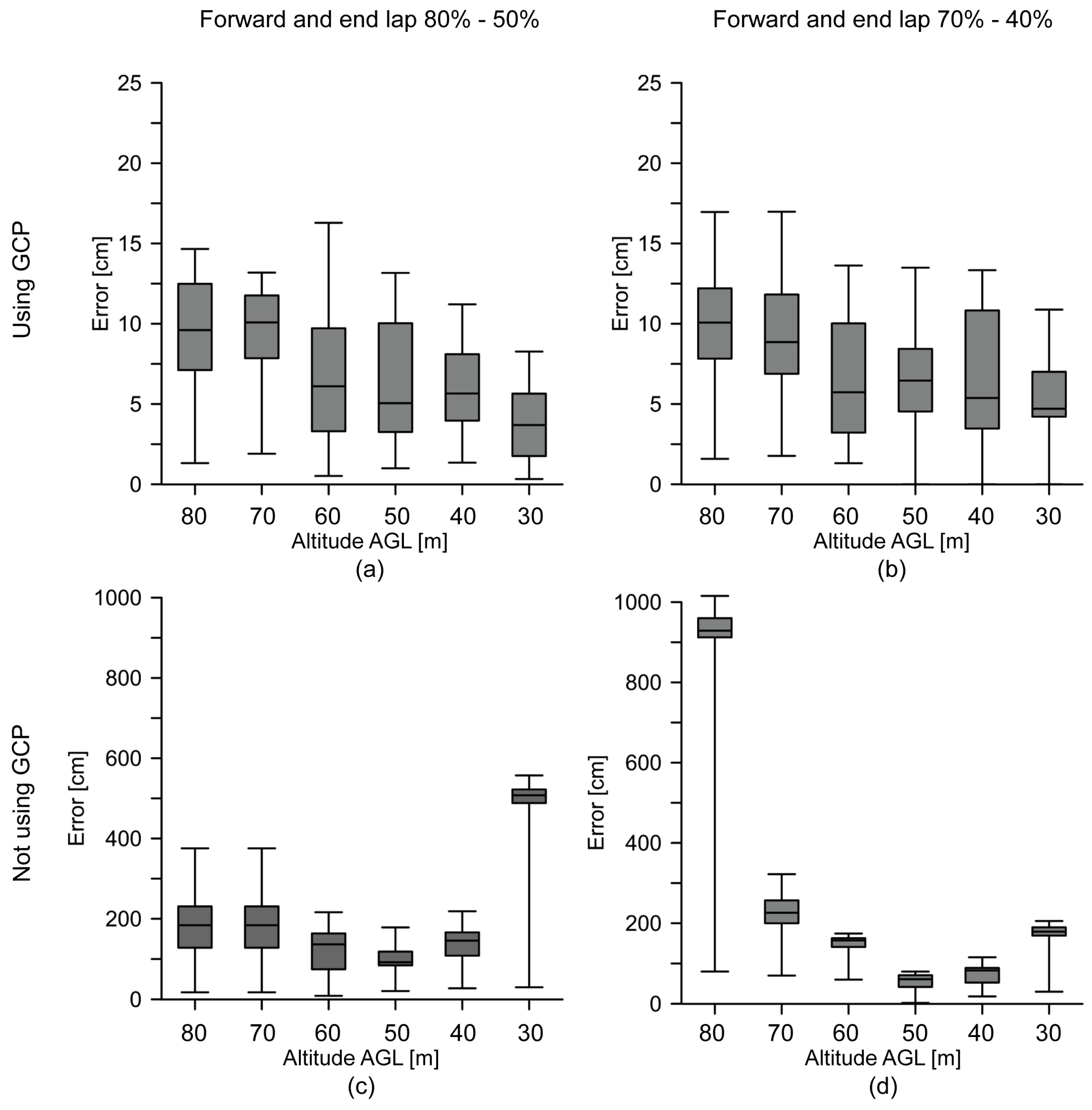
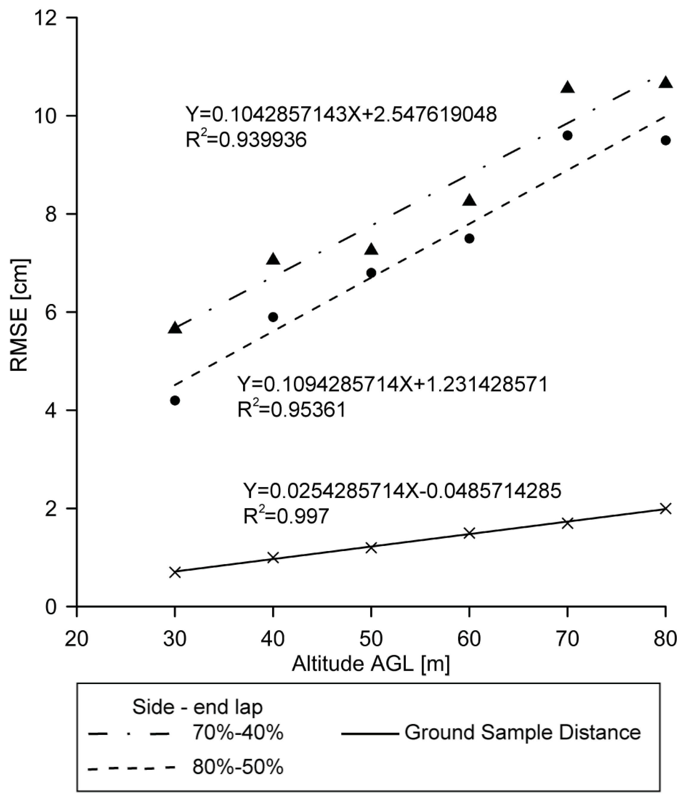
3.1. Assesement of Absolute Positional Accuracy
3.2. Assesment of Relative Positional Accuracy
4. Conclusions
Acknowledgments
Author Contributions
Conflicts of Interest
References
- Schindling, J.; Gibbes, C. Lidar as a tool for archaeological research: A case study. Archaeol. Anthropol. Sci. 2014, 6, 411–423. [Google Scholar] [CrossRef]
- Fryer, J.; Mitchell, H.; Chandler, J. Applications of 3D Measurements from Images; Whittles Publishing: Caithness, UK, 2007. [Google Scholar]
- Altaweel, M. The use of ASTER satellite imagery in archaeological contexts. Archaeol. Prospect. 2005, 12, 151–166. [Google Scholar] [CrossRef]
- Rosa, L.; Nicola, M. On the potential of quickbird data for archaeological prospection. Int. J. Remote Sens. 2006, 27, 3607–3614. [Google Scholar]
- Wilkinson, K.N.; Beck, A.R.; Philip, G. Satellite imagery as a resource in the prospection for archaeological sites in central Syria. Geoarchaeology 2006, 21, 735–750. [Google Scholar] [CrossRef]
- Chiabrando, F.; Nex, F.; Piatti, D.; Rinaudo, F. UAV and RPV systems for photogrammetric surveys in archaelogical areas: Two tests in the Piedmont region (Italy). J. Archaeol. Sci. 2011, 38, 697–710. [Google Scholar] [CrossRef]
- Verhoeven, G.J.J. Providing an archaeological bird's-eye view—An overall picture of ground-based means to execute low-altitude aerial photography (LAAP) in Archaeology. Archaeol. Prospect. 2009, 16, 233–249. [Google Scholar] [CrossRef]
- Mozas-Calvache, A.T.; Pérez-García, J.L.; Cardenal-Escarcena, F.J.; Mata-Castro, E.; Delgado-García, J. Method for photogrammetric surveying of archaeological sites with light aerial platforms. J. Archaeol. Sci. 2012, 39, 521–530. [Google Scholar] [CrossRef]
- Gomez-Lahoz, J.; Gonzalez-Aguilera, D. Recovering traditions in the digital era: The use of blimps for modelling the archaeological cultural heritage. J. Archaeol. Sci. 2009, 36, 100–109. [Google Scholar] [CrossRef]
- Bogacki, M.; Malkowski, W.; Misiewicz, K. Kite Aerial Photography (KAP) as a Tool for Completing GIS Models. Ptolemais (Libya) Case Study. In Remote Sensing for Archaeology and Cultural Heritage Management, Proceedings of the 1st International EARSeL Workshop, CNR, Rome, Italy, 30 September–4 October 2008; Lasaponara, R., Masini, N., Eds.; pp. 329–332.
- Bendea, H.; Chiabrando, F.; Giulio Tonolo, F.; Marenchino, D. Mapping of archaeological areas using a low-cost UAV. The augusta bagiennorum test site. In Proceedings of the XXI International CIPA Symposium, Athens, Greece, 1–6 October 2007.
- Sauerbier, M.; Eisenbeiss, H. UAVs for the documentation of archaeological excavations. Int. Arch. Photogramm. Remote Sens. Spat. Inf. Sci. 2010, 38, 526–531. [Google Scholar]
- Paparoditis, N.; Souchon, J.-P.; Martinoty, G.; Pierrot-Deseilligny, M. High-end aerial digital cameras and their impact on the automation and quality of the production workflow. ISPRS J. Photogramm. Remote Sens. 2006, 60, 400–412. [Google Scholar] [CrossRef]
- Müller, J.; Gärtner-Roer, I.; Thee, P.; Ginzler, C. Accuracy assessment of airborne photogrammetrically derived high-resolution digital elevation models in a high mountain environment. ISPRS J. Photogramm. Remote Sens. 2014, 98, 58–69. [Google Scholar] [CrossRef]
- Ackermann, F. Operational rules and accuracy models for GPS-aerotriangulation. Arch. ISPRS 1992, 1, 691–700. [Google Scholar]
- Pajares, G. Overview and current status of remote sensing applications based on unmanned aerial vehicles (UAVs). Photogramm. Eng. Remote Sens. 2015, 81, 281–329. [Google Scholar] [CrossRef]
- Mesas-Carrascosa, F.J.; Notario-García, M.D.; de Larriva, J.E.M.; de la Orden, M.S.; Porras, A.G.-F. Validation of measurements of land plot area using UAV imagery. Int. J. Appl. Earth Observ. Geoinf. 2014, 33, 270–279. [Google Scholar] [CrossRef]
- Mesas-Carrascosa, F.J.; Rumbao, I.C.; Berrocal, J.A.B.; Porras, A.G.-F. Positional quality assessment of orthophotos obtained from sensors onboard multi-rotor UAV platforms. Sensors 2014, 14, 22394–22407. [Google Scholar] [CrossRef] [PubMed]
- Mesas-Carrascosa, F.-J.; Torres-Sánchez, J.; Clavero-Rumbao, I.; García-Ferrer, A.; Peña, J.-M.; Borra-Serrano, I.; López-Granados, F. Assessing optimal flight parameters for generating accurate multispectral orthomosaicks by UAV to support site-specific crop management. Remote Sens. 2015, 7, 12793–12814. [Google Scholar] [CrossRef]
- Hendrickx, M.; Gheyle, W.; Bonne, J.; Bourgeois, J.; De Wulf, A.; Goossens, R. The use of stereoscopic images taken from a microdrone for the documentation of heritage—An example from the Tuekta burial mounds in the Russian Altay. J. Archaeol. Sci. 2011, 38, 2968–2978. [Google Scholar] [CrossRef]
- Hengl, T. Finding the right pixel size. Comput. Geosci. 2006, 32, 1283–1298. [Google Scholar] [CrossRef]
- Szeliski, R. Structure from motion. In Computer Vision: Algorithms and Applications; Springer: London, UK, 2011; pp. 303–334. [Google Scholar]
- Micheletti, N.; Chandler, J.H.; Lane, S.N. Structure from Motion (SFM) Photogrammetry. In Geomorphological Techniques; Clarke, L.E., Nield, J.M., Eds.; British Society for Geomorphology: London, UK, 2015; Chapter 2, Section 2.2; pp. 1–12. [Google Scholar]
- Fonstad, M.A.; Dietrich, J.T.; Courville, B.C.; Jensen, J.L.; Carbonneau, P.E. Topographic structure from motion: A new development in photogrammetric measurement. Earth Surf. Process. Landf. 2013, 38, 421–430. [Google Scholar] [CrossRef]
- Wang, J.; Ge, Y.; Heuvelink, G.B.M.; Zhou, C.; Brus, D. Effect of the sampling design of ground control points on the geometric correction of remotely sensed imagery. Int. J. Appl. Earth Observ. Geoinf. 2012, 18, 91–100. [Google Scholar] [CrossRef]
- Carvajal, F.; Agüera, F.; Martínez, P.J. Effects of image orientation and GCP distribution on unmanned aerial vehicle photogrammetry projects on a road cut slope. J. Appl. Remote Sens. 2016, in press. [Google Scholar] [CrossRef]
- Agüera, F.; Carvajal, F.; Pérez, M.; Orgaz, F. Multi-temporal imaging using an unmanned aerial vehicle for monitoring a sunflower crop. Biosyst. Eng. 2015, 132, 19–27. [Google Scholar]
- Zhang, Y.; Xiong, J.; Hao, L. Photogrammetric processing of low-altitude images acquired by unpiloted aerial vehicles. Photogramm. Rec. 2011, 26, 190–211. [Google Scholar] [CrossRef]
- Küng, O.; Strecha, C.; Beyeler, A.; Zufferey, J.-C.; Floreano, D.; Fua, P.; Gervaix, F. The accuracy of automatic photogrammetric techniques on ultra-light UAV imagery. In Proceedings of the UAV-g 2011-Unmanned Aerial Vehicle in Geomatics, Zürich, Switzerland, 14–16 September 2011.
- Kraus, K. Photogrammetry—Geometry from Images and Laser Scans; Walter de Gruyter: Goettingen, Germany, 2007. [Google Scholar]
- Yuan, X.; Fu, J.; Sun, H.; Toth, C. The application of gps precise point positioning technology in aerial triangulation. ISPRS J. Photogramm. Remote Sens. 2009, 64, 541–550. [Google Scholar] [CrossRef]
- Snavely, N.; Seitz, S.M.; Szeliski, R. Photo tourism: Exploring photo collections in 3D. ACM Trans. Graph. 2006, 25, 835–846. [Google Scholar] [CrossRef]
- Inpho Uasmaster. Available online: http://www.trimble.com/geospatial/inpho-uasmaster.Aspx (accessed on 1 October 2016).
- International Organization for Standardization (ISO). Geographic Information—Data Quality; ISO: London, UK, 2013; Volume 19157. [Google Scholar]
- QGIS. Available online: http://www.qgis.org/en/site/ (accessed on 27 October 2016).
- Photogrammetric Engineering & Remote Sensing. ASPRS Positional Accuracy Standards for Digital Geospatial Data. American Society for Photogrammetry and Remote Sensing (ASPRS): Bethesda, MD, USA, 2015; Volume 81, pp. A1–A26. [Google Scholar]
- Mapping, Charting and Geodesy Accuracy. Available online: http://earth-info.nga.mil/publications/specs/printed/600001/600001_Accuracy.pdf (accessed on 1 June 2016).
- Juran, J.M.; De Feo, J.A. Juran’s Quality Handbook: The Complete Guide to Performance Excellence, 6th ed.; McGraw-Hill Education: New York, NY, USA, 2010. [Google Scholar]
- Turner, D.; Lucieer, A.; Wallace, L. Direct georeferencing of ultrahigh-resolution UAV imagery. IEEE Trans. Geosci. Remote Sens. 2014, 52, 2738–2745. [Google Scholar] [CrossRef]
- Westoby, M.J.; Brasington, J.; Glasser, N.F.; Hambrey, M.J.; Reynolds, J.M. ‘Structure-from-Motion’ photogrammetry: A low-cost, effective tool for geoscience applications. Geomorphology 2012, 179, 300–314. [Google Scholar] [CrossRef]
- Nex, F.; Remondino, F. UAV for 3D mapping applications: A review. Appl. Geomat. 2014, 6, 1–15. [Google Scholar] [CrossRef]
- Williams, K.; Olsen, M.J.; Roe, G.V.; Glennie, C. Synthesis of transportation applications of mobile LiDAR. Remote Sens. 2013, 5, 4652–4692. [Google Scholar] [CrossRef]
- Wallace, L.; Lucieer, A.; Watson, C.; Turner, D. Development of a UAV-LiDAR system with application to forest inventory. Remote Sens. 2012, 4, 1519–1543. [Google Scholar] [CrossRef]
- Carter, W.E.; Shrestha, R.L.; Fernandez-Diaz, J.C. Archaeology from the air. Am. Sci. 2016, 104, 28–35. [Google Scholar] [CrossRef]


| Parameters | Value | Parameters | Value |
|---|---|---|---|
| Focal length (mm) | 16.6286 | Radial Distortion K2 | 0.0290259 |
| Principal point—X (mm) | 12.2712 | Radial Distortion K3 | −0.0338008 |
| Principal point—Y (mm) | 7.76064 | Tangential Distortion T1 | −0.00162188 |
| Radial Distortion K1 | −0.0108059 | Tangential Distortion T2 | −0.00094999 |
| Altitude AGL (m) | Forward/Side Lap 70%–40% | Forward/Side Lap 80%–50% | ||
|---|---|---|---|---|
| Time Duration | Num Images | Time Duration | Num Images | |
| 30 | 0:07:12 | 27 | 0:07:35 | 34 |
| 40 | 0:02:40 | 12 | 0:06:03 | 27 |
| 50 | 0:02:12 | 10 | 0:03:08 | 14 |
| 60 | 0:01:52 | 8 | 0:02:44 | 12 |
| 70 | 0:00:46 | 4 | 0:00:56 | 5 |
| 80 | 0:00:33 | 3 | 0:00:56 | 5 |
| Altitude AGL (m) | GSD (cm) | Forward/End Lap (%) | GCP RMSE (cm) | No GCP RMSE (cm) |
|---|---|---|---|---|
| 30 | 0.7 | 80%/50% | 3.8 | 507.8 |
| 70%/40% | 5.4 | 178.0 | ||
| 40 | 1 | 80%/50% | 5.9 | 138.4 |
| 70%/40% | 6.3 | 73.3 | ||
| 50 | 1.2 | 80%/50% | 6.2 | 99.2 |
| 70%/40% | 6.5 | 53.8 | ||
| 60 | 1.5 | 80%/50% | 6.9 | 120.7 |
| 70%/40% | 6.8 | 151.9 | ||
| 70 | 1.7 | 80%/50% | 9.6 | 179.6 |
| 70%/40% | 9.2 | 229.0 | ||
| 80 | 2 | 80%/50% | 9.5 | 179.6 |
| 70%/40% | 10.0 | 934.2 |
| GCPs | Forward–End Lap | Altitude AGL (m) | |||||
|---|---|---|---|---|---|---|---|
| 30 | 40 | 50 | 60 | 70 | 80 | ||
| With | 70%–40% | 5.1 | 5.5 | 6.1 | 6.2 | 6.2 | 6.5 |
| 80%–50% | 4.5 | 4.5 | 4.9 | 5.0 | 5.3 | 5.1 | |
| Without | 70%–40% | 44.0 | 63.3 | 56.7 | 38.1 | 44.4 | 88.8 |
| 80%–50% | 21.4 | 33.4 | 19.7 | 6.9 | 42.5 | 16.6 | |
© 2016 by the authors; licensee MDPI, Basel, Switzerland. This article is an open access article distributed under the terms and conditions of the Creative Commons Attribution (CC-BY) license (http://creativecommons.org/licenses/by/4.0/).
Share and Cite
Mesas-Carrascosa, F.-J.; Notario García, M.D.; Meroño de Larriva, J.E.; García-Ferrer, A. An Analysis of the Influence of Flight Parameters in the Generation of Unmanned Aerial Vehicle (UAV) Orthomosaicks to Survey Archaeological Areas. Sensors 2016, 16, 1838. https://doi.org/10.3390/s16111838
Mesas-Carrascosa F-J, Notario García MD, Meroño de Larriva JE, García-Ferrer A. An Analysis of the Influence of Flight Parameters in the Generation of Unmanned Aerial Vehicle (UAV) Orthomosaicks to Survey Archaeological Areas. Sensors. 2016; 16(11):1838. https://doi.org/10.3390/s16111838
Chicago/Turabian StyleMesas-Carrascosa, Francisco-Javier, María Dolores Notario García, Jose Emilio Meroño de Larriva, and Alfonso García-Ferrer. 2016. "An Analysis of the Influence of Flight Parameters in the Generation of Unmanned Aerial Vehicle (UAV) Orthomosaicks to Survey Archaeological Areas" Sensors 16, no. 11: 1838. https://doi.org/10.3390/s16111838
APA StyleMesas-Carrascosa, F.-J., Notario García, M. D., Meroño de Larriva, J. E., & García-Ferrer, A. (2016). An Analysis of the Influence of Flight Parameters in the Generation of Unmanned Aerial Vehicle (UAV) Orthomosaicks to Survey Archaeological Areas. Sensors, 16(11), 1838. https://doi.org/10.3390/s16111838