
Bangladesh Sundarbans: Present Status of the Environment and Biota

Abstract
:1. Introduction
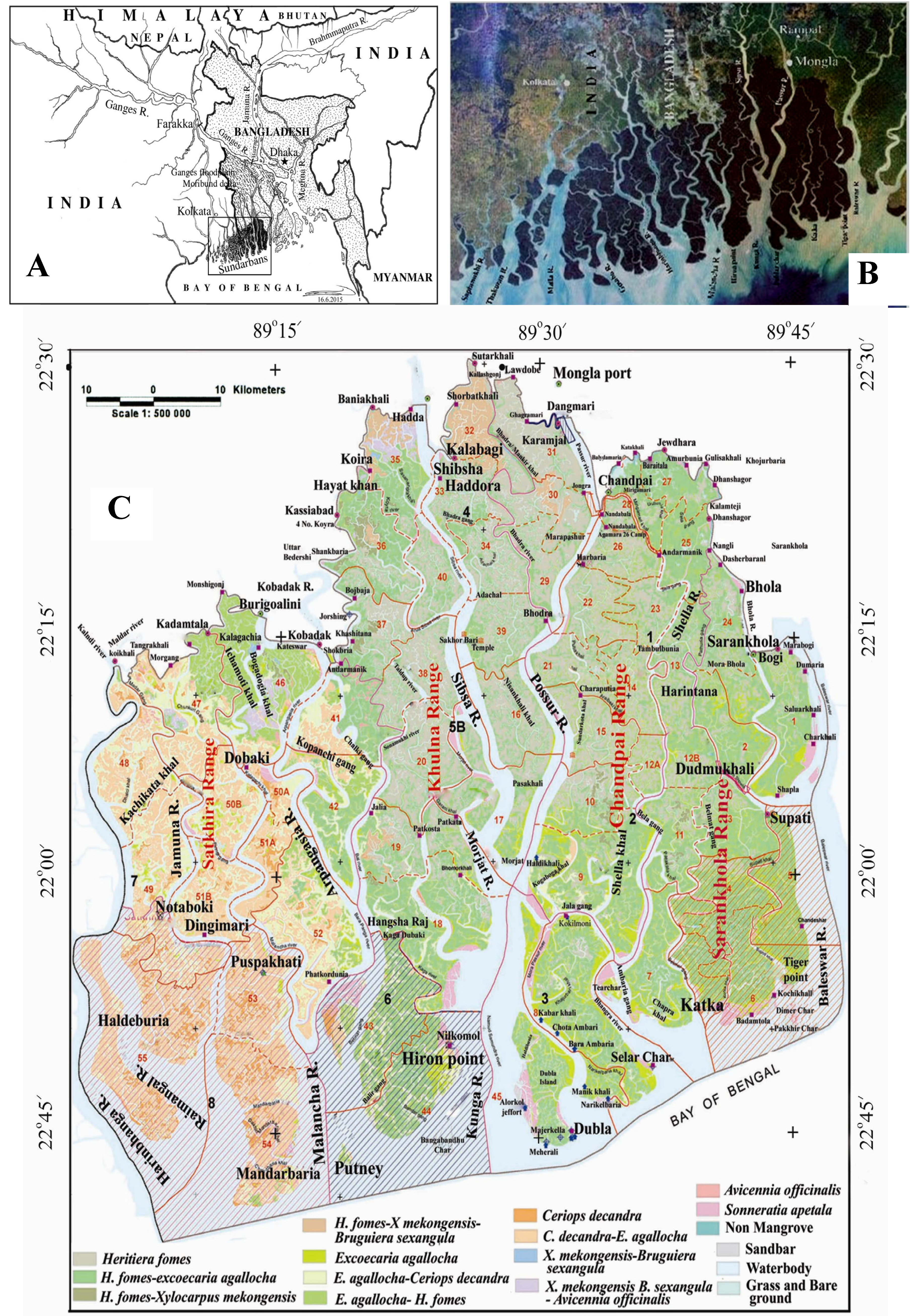
2. The Sundarbans and Their Origin
3. Present Status of the Bangladesh Sundarbans
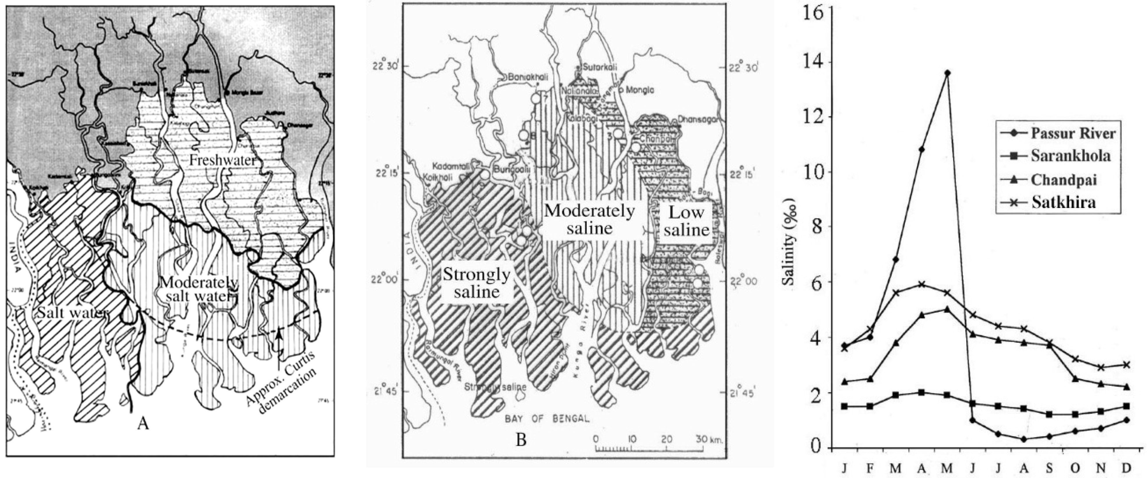
Physical and Chemical Environment

- (a)
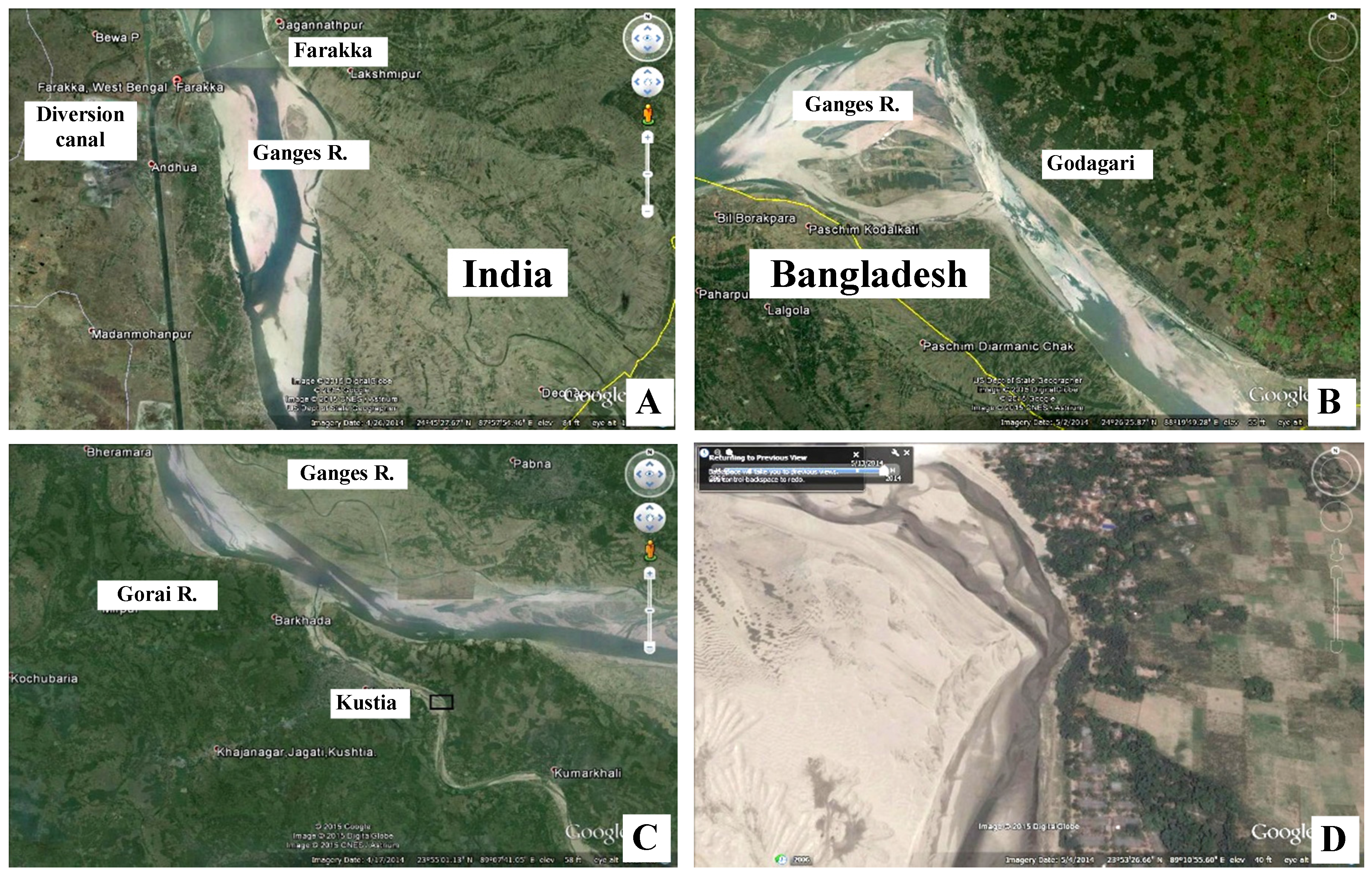
- The eastern subsystem is situated between Passur and Baleswar Rivers and receives freshwater from the Ganges through Gorai-Madhumati (which holds little freshwater during the dry period) and lower Meghna. The subsystem is of low salinity (Oligohaline, <5‰).
- (b)
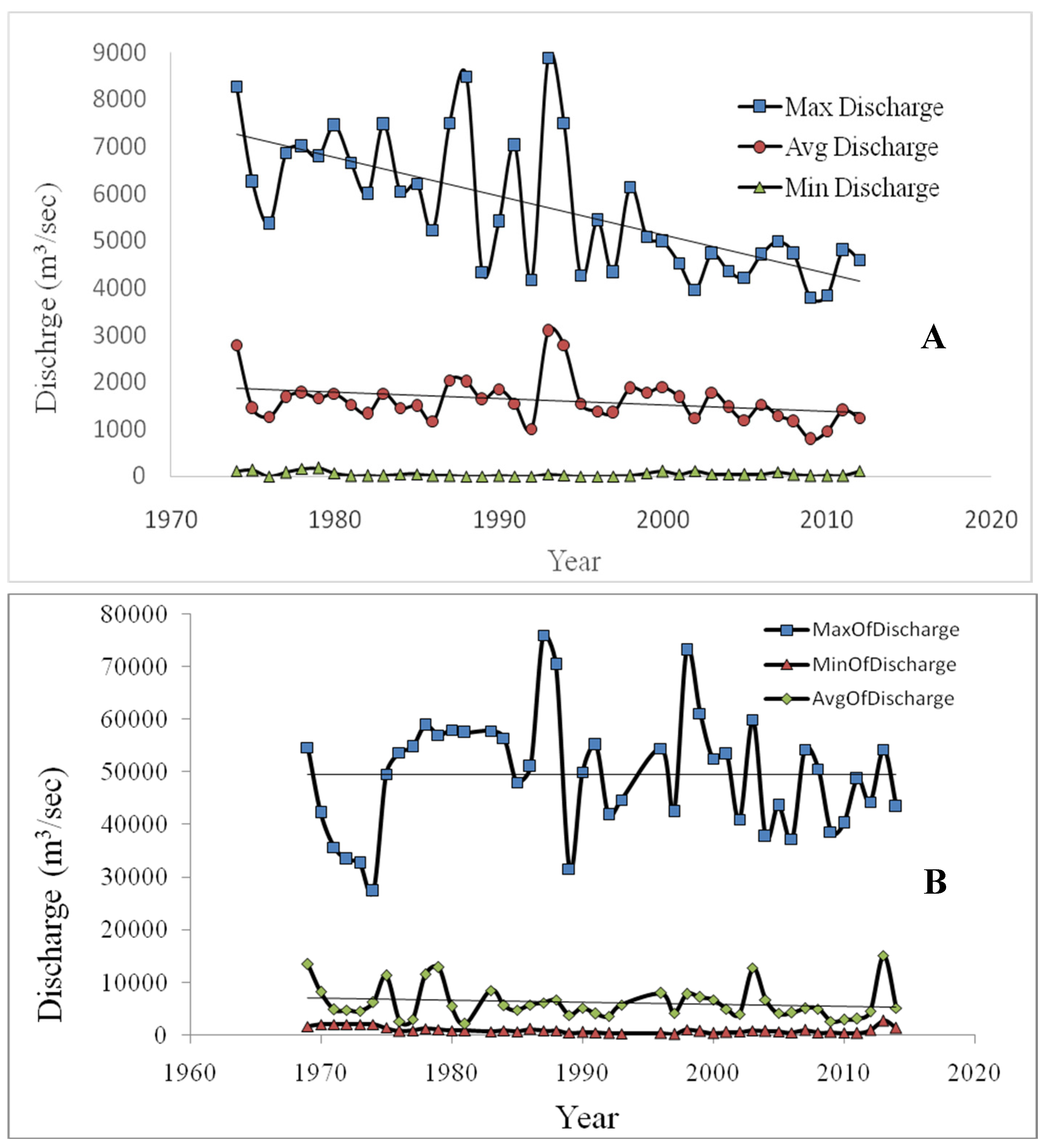
- The central subsystem is located west of Passur and east of Sipsa. The Passur is connected with the Ganges through the Gorai River. However, the connection is blocked in the lean period by sand bars (chars). Due to reduced flow in the Ganges, the catchment area is extensively sedimented resulting in degradation of BSMF mainly due to increasing salinity (Mesohaline, 5‰ to <18‰).
- (c)
- Western subsystem is located in the west of Sipsa River to the east of Raimangal-Harinbhanga River along the border. The subsystem originated from several perennial water bodies (moribund delta) (Figure 1). The Sipsa is connected with Passur which is already with low freshwater flow. Thus, the system does not receive any surface water from upstream during the dry period except local run off [21]. Seawater intrudes making the subsystem saline (Polyhaline, 18‰ to 30‰).


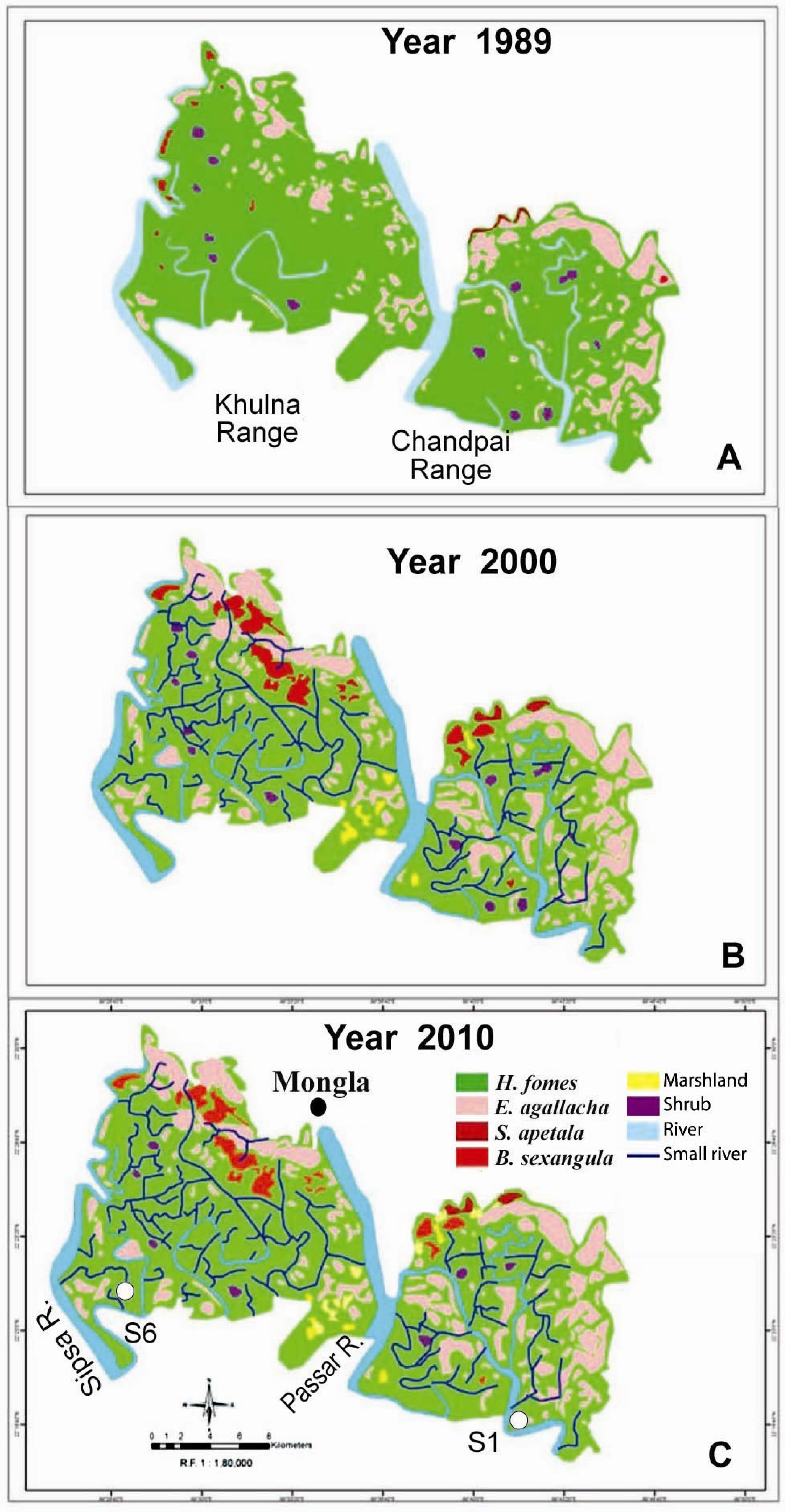
| Classes | Plant Cover and Water Area | Changes | ||||
|---|---|---|---|---|---|---|
| 1989 | 2000 | 2010 | 1989–2000 | 2000–2010 | Overall | |
| Heritiera fomes | 23,028 | 19,309 | 16,408 | −3719 (16.15) | −2901 (15.02) | −6620 (28.75) |
| Excoecaria agallocha | 15,184 | 15,828 | 16,200 | +644 (4.24) | +372 (02.35) | +1016 (6.7) |
| Sonneratia apetala | 44 | 1906 | 109 | +1862 (4231) | −1797 (94.28) | +65 (148) |
| Bruguiera sexangula | 191 | 8169 | 3026 | +7978 (4177) | −5143 (63) | +2835 (1484) |
| Marshes | - | 387 | 585 | +387 (100) | +198 (33.85) | +585 (100) |
| Shrubs | 570 | 463 | 367 | −107 (18.77) | −96 (20.73) | −203 (35.61) |
| Water | 4727 | 5581 | 6009 | +854 (18.07) | +428 (7.67) | +1282 (27.12) |
| Total area | 44,301 | 44,328 | 42,704 | +27 (0.06) | −1624 (3.66) | −1598 (3.60) |
4. Floral Diversity
| Scientific Name | Family | Vernacular Name | Type of Plant |
|---|---|---|---|
| Acanthus ilicifolius | Acanthaceae | Hargoza | Scrambling herb |
| Acrostichum aureum | Pteridiaceae | Hodo, tiger fern | Gregarious fern |
| Aegialitis rotundifolia | Plumbaginaceae | Dhalchaka | Small tree |
| Aegiceras coriculatum | Myrsinaceae | Khalisha, Khalshi | Shrub or small tree |
| Amoora cucullata | Meliaceae | Amur | Small tree |
| Avicennia alba and/or | Avicenniaceae | Sada baen | Small tree |
| A. marina | Avicenniaceae | Morcha baen | Small tree |
| Avicennia officinalis | Avicenniaceae | Baen | Tree |
| Barringtonia racemosa | Barringtoniaceae | Kumba, Kumbi | Small tree |
| Blumea amplectens | Compositae | Hash | Aromatic herb |
| Brownlowia tersa | Tiliaceae | Ota sundri | Climbing shrub |
| Bruguiera gymnorrhiza | Rhizophoraceae | Kankra | Tree |
| Caesalpinia crista | Leguminosae | Kutum katta | Climbing armed shrub |
| Cerbera manghas | Apocynaceae | Dagor | Small tree |
| Ceriops decandra | Rhizophoraceae | Goran | Shrub or small tree |
| Clerodendrum inerme | Verbenaceae | Sitka, Sitki | Climbing shrub |
| Cynometra ramiflora | Leguminosae | Shingra | Shrub |
| Cyperus javanicus | Cyperaceae | Kucha, Kusha | Sedge |
| Dalbergia candenatensish | Leguminosae | Chanda lota | Scrambling climber |
| D. spinosa | Leguminosae | Chanda katta | Climbing armed shrub |
| Dendrophthoe falcate | Loranthaceae | Porgassa | Woody parasite on trees |
| Derris trifoliate | Leguminosae | Gila lota, kali lota | Climber |
| Diospyros peregrine | Ebenaceae | Gaeb | Tree |
| Drypetes sp. | Euphorbiaceae | Achet | Climbing shrub |
| Eriochloa procera | Gramineae | Nol hash | Grass |
| Eugenia fruticosa | Myrtaceae | Ban jam, Jam gach | Small tree |
| Excoecaria agallocha | Euphorbiaceae | Gewa | Tree |
| E. indica | Euphorbiaceae | Batla, Batul | Small tree |
| Ficusretusa | Moraceae | Jir | Tree with aerial roots |
| Flagellaria indica | Flagellariaceae | Abetaa | Climber |
| Flueggia virosa | Euphorbiaceae | Sitka, Sitki | Climbing shrub |
| Heritiera fomes | Sterculiaceae | Sundri | Tree |
| Hibiscus tiliaceous | Malvaceae | Bhola | Shrub |
| Hoyaparasitica | Asclepiadaceae | Agusha | Climber |
| Imperata cylindrical | Gramineae | Grass | |
| Intsia bijuga | Leguminosae | Bhaela, Bharal | Small tree |
| Ipomoea pes-caprae | Convulvulaceae | Gash | Succulent herb |
| Ixora sp. | Rubiaceae | Bon bakul | Small tree |
| Kandelia candel | Rhizophoraceae | Gura, Gural | Small tree |
| Leea aequata | Leeaceae | Shrub | |
| Lepisanthes rubiginosa | Sapindaceae | Bon lichu | Tree |
| Lumnitzera racemosa | Combretaceae | Kirpa, Kripa | Small tree |
| Macrosolen cochinchinensis | Loranthaceae | Porgassa | Woody parasite |
| Mallotus repandus | Euphorbiaceae | Bon notoy | Climbing shrub |
| Macuna gigantean | Leguminosae | Doyal | Climber |
| Myriostachya wightiana | Gramineae | Dhanshi | Grass, on accretions |
| Nypa fruticans | Palmae | Golpata | Palm, underground stem |
| Pandanus foetidus | Pandanaceae | Kewa katta | Prickly screw-pine |
| Petunga roxburghii | Rubiaceae | Narikili | Small tree |
| Phoenix paludosa | Palmae | Hantal | Thorn palm |
| Phragmites karka | Gramineae | Nol khagra | Grass |
| Pongamia pinnata | Leguminosae | Karanja | Small tree |
| Premna corymbosa | Verbenaceae | Serpoli, Setpoli | Shrub or small tree |
| Rhizophora mucronata | Rhizophoraceae | Garjan, Jhanna | Tree with stilt roots |
| Salacia chinensis | Celastraceae | Choyt barai | Small tree |
| Sarcolobus globosus | Asclcpiadaccae | Bowali lota | Climber |
| Sonneratia apetala | Sonneratiaceae | Keora | Tree |
| S. caseolaris | Sonneratiaceae | Choyla | Small tree |
| Stenochlaena palustris | Blechnaceae | Dekilota | Climbing fern |
| Tamarix indica | Tamaricaceae | Jhao, Nona jhao | Small tree |
| Tetrastigma bracteolatum | Vitidiaceae | Golgoti lota | Climber |
| Thunbergia sp. | Thunbergiaceae | Jermani lota | Climber |
| Viscum monoicum | Loranthaceae | Shamulota | Woody parasite on trees |
| Xylocarpus granatum | Meliaceae | Dhundul | Small tree |
| X. mekongensis | Meliaceae | Passur | Tree |
| Phytoplankton | Benthic Algae |
|---|---|
Chlorophyceae
| Cyanophyceae
|
| Forest Types | Area Occupied (%) | |
|---|---|---|
| 1959 | 1983 | |
| Heritiera fomes | 31.6 | 21.0 |
| H. fomes-Excoecaria agallocha | 24.4 | 29.7 |
| E. agalocha-H. Fomes | 15.6 | 14.8 |
| Total | 71.5 | 65.5 |
| Sl. No. | Inventory/Trend | H. Fomes (dbh ≥ 15 cm) | E. Agallocha | Total Trees |
|---|---|---|---|---|
| 1. | 1959 [34] * | 211 | 61 | 296 |
| 2. | 1983 [14] * | 125 | 35 | 180 |
| 3. | 1996 * | 106 | 20 | 144 |
| 4. | In 2020 ** | 80 | 7 | 109 |
5. Faunal Diversity
6. Resources of the Bangladesh Sundarbans
| Sl. No. | Type of Forest | 2008–2009 | 2012–2013 | ||
|---|---|---|---|---|---|
| Produces (Unit) | Amount | Revenue | Amount | Revenue | |
| 1. | Excoecaria agallocha (m−3) * | 613 | 779,626 | 252 | 1,254,319 |
| 2. | Ceriops decandra (no.) * | 88,708 | 363,628 | 66578 | 379,290 |
| 3. | Nypa fruticans (ton) | 37,534 | 4,620,713 | 31,761.6 | 8,275,050 |
| 4. | Fishes (ton) | 4524.5 | 21,331,210 | 3484.5 | 13,569,648 |
| 5. | Grass (ton) | 493 | 10,853 | 1101 | 29,837 |
| 6. | Phoenix paludosa (ton) | 60 | 42,846 | 73.02 | 105,899 |
| 7. | Honey (ton) | 110 | 608,520 | 233 | 1,747,422 |
| 8. | Mollusk Shell (ton) | 1349 | 40,987 | 182.714 | 32,888 |
| 9. | Wax (ton) | 22.81 | 228,195 | 58.93 | 589,315 |
| 10. | Crab (ton) | 1318.5 | 3,743,765 | 1253.80 | 4,901,712 |
| 11. | Tourists (No.) | 183,600 | 4,419,960 | 150,037 | 19,873,725 |
| 12. | Wood (m−3) ** | 522.60 | 8,452,509 | 293 | 2,220,170 |
| 13. | Fuel wood (m−3) ** | 850 | 557,209 | 453 | 8,39,173 |
| 14. | Miscellaneous | - | 10,040,444 | - | 13,878,556 |
| Total | 48,202,163 US $ = 717,409 | - | 67,697,004 US $ = 879,181 | ||
7. Threats to the Systems
8. Conservation

9. Reclamation of the BSMF

“by 2050, the Sundarban Delta is rich in biodiversity and highly capable of extending sufficient ecosystem goods and services, to provide sustained social, economic and environmental benefits to the neighbouring communities, nation and beyond, for present and future generations, under a changing climatic scenario”.[44]
          For things created by God

      For the Sundarbans God created the Royal Bengal Tiger-
      Whose eye
      Keeps the world in awe.
      For the singers God created
      Her voice.
      For the poet-
      His words.
      For Bangladesh-
      The Sundarbans.
      What happens to the singer-
            who loses her voice.
      What happens to the poet-
            who loses his words?
      Bangladesh take care-
            of the Sundarbans.
10. Conclusions
Acknowledgments
Conflicts of Interest
References
- Khan, E. The Bangladesh Sundarbans; Wildlife Trust of Bangladesh (WTB): Dhaka, Bangladesh, 2011; p. 168. [Google Scholar]
- World Conservation Monitoring Centre. UNEP: Protected Areas Database. 2005. Available online: http://www.wcmc.org.uk/data/database/un_combo.html (accessed on 29 June 2015).
- Integrated Resources Management Plans for the Sundarbans; Forest Department, Ministry of Environment and Forests: Dhaka, Bangladesh, 2010; Volume I, pp. 1–281.
- Giri, C.; Long, J.; Abbas, S.; Murali, R.M.; Qamer, F.M.; Pengra, B.; Thau, D. Distribution and dynamics of mangrove forests of South Asia. J. Environ. Manage. 2014, 100, 1–11. [Google Scholar] [CrossRef] [PubMed]
- Spalding, M.; Kainuma, M.; Collins, L. World Atlas of Mangrove; Earth Scan Press: London, UK, 2010. [Google Scholar]
- Giri, C.; Ochieng, E.; Tieszen, L.L.; Zhu, Z.; Singh, A.; Loveland, T.; Masek, J.; Duke, N. Status and distribution of mangrove forests of the world using earth observation satellite data. Glob. Ecol. Biogeogr. 2011, 20, 154–159. [Google Scholar] [CrossRef]
- Spalding, M.D.; Blasco, F.; Field, C.D. World mangrove Atlas; International Society Mangrove Ecosystem: Okinawa, Japan, 1997; p. 178. [Google Scholar]
- United Nations Environment Programme. Global Environment Outlook Yearbook 2004; United Nations Environment Programme: Nairobi, Kenia, 2004. [Google Scholar]
- Mangrove Action Plan. 2005. Available online: http://mangroveactionproject.org (accessed on 29 June 2015).
- Millenium Ecosystem Assessment. In Mille Ecosystems and Human Well-Being: Synthesis; Island Press: Washington, DC, USA, 2005.
- Duke, N.C.; Meynecke, J.O.; Dittmann, S.; Ellison, A.M.; Anger, K.; Berger, U.; Cannicci, S.; Diele, K.; Ewel, K.C.; Field, C.D. A world without mangroves? Science 2007, 317, 41–42. [Google Scholar] [CrossRef] [PubMed]
- Food and Agriculture Organization of the United Nations. The World Mangroves 1980–2005; Forestry Paper 153; FAO: Rome, Italy, 2007. [Google Scholar]
- Gilman, E.; Ellison, J.; Duke, N.C.; Field, C. Threats to mangroves from climate change and adaptation options: A Review. Aquat. Bot. 2008, 89, 237–250. [Google Scholar] [CrossRef]
- Chaffey, D.R.; Miller, F.R.; Sandom, K.H. A Forest Inventory of the Sundarbans, Bangladesh; Land Resources Development Centre: Surrey, UK, 1985; p. 196. [Google Scholar]
- Curtis, S.J. Working Plan for the Forests of the Sundarbans Division for the Period from 1st April 1931 to 31st March 1933; Bengal Govt. Press: Calcutta, Bengal, 1933. [Google Scholar]
- Chaudhuri, A.B.; Choudhury, A. Mangroves of Sundarbans. Volume One: India; IUCN: Bangkok, Thailand, 1994; p. 247. [Google Scholar]
- Sanyal, P.; Banerjee, L.K.; Choudhury, M.K. Dancing Mangals of India Sundarbans. J. Indian Soc. Coast. Agric. Res. 1984, 2, 10–16. [Google Scholar]
- Rashid, H.E. Geography of Gangladesh; University Press Ltd.: Dacca, Bangladesh, 1977; p. 579. [Google Scholar]
- Khan, H.R. Irrigation water requirements in Bangladesh. In River Basin Development; Zaman, M., Biswas, A.K., Khan, A.H., Nishat, A., Eds.; Tycooly International Publishing Ltd.: Dublin, UK, 1983; pp. 150–157. [Google Scholar]
- Aziz, A. Environment: Water Issue. In Proceedings of the Annual Botanical Conference 2013, Bogra, Bangladesh, 31 May 2014.
- Karim, A. The physical Environment. In Mangroves of Sundarbans. Volume 2: Bangladesh; Hussain, Z., Acharya, G., Eds.; IUCN: Bangkok, Thailand, 1994; pp. 11–41. [Google Scholar]
- Siddiqi, N.A. Regeneration Status and Influence of Animals on Regeneration in the Sundarbans Mangrove Forests. Ph.D. Thesis, University Dhaka, Dhaka, Bangladesh, 1992. [Google Scholar]
- Siddiqi, N.A. Natural regeneration. In Mangroves of Sundarban. Volume Two: Bangladesh; Hussain, Z., Acharya, G., Eds.; IUCN: Bangkok, Thailand, 1994; pp. 75–99. [Google Scholar]
- Hassan, M.M.; Mazumder, A.H.; Islam, A.T.M.; Hossain, A.T.M.E. Soil hydrology and salinity of the Sundarbans in relation to top dying, regeneration and survival of Sundri (Heritiera fomes). In Proceedings of the Seminar on Top Dying of Sundri Trees; Bangladesh Agricultural Research Council: Dhaka, Bangladesh, 1990; pp. 1–11. [Google Scholar]
- Aziz, A.; Rahman, M.; Ahmed, A. Diversity, distribution and density of estuarine phytoplankton in the Sundarban Mangrove Forests. Bangladesh J. Bot. 2012, 41, 87–95. [Google Scholar] [CrossRef]
- Samad, M.M.A. Groundwater quality in the coastal areas of Bangladesh. Bangladesh J. Geol. 1986, 5, 11–18. [Google Scholar]
- Lugo, A.E.; Snedaker, S.C. The ecology of Mangroves. Annu. Rev. Eco. Syst. 1974, 5, 39–64. [Google Scholar] [CrossRef]
- Siddiqi, N.A. Mangrove Forestry in Bangladesh; Institute of Forestry and Environmental Sciences, Chittagong University: Chittagong, Bangladesh, 2001; p. 201. [Google Scholar]
- Ahmed, A.; Aziz, A.; Khan, A.Z.M.N.A.; Islam, M.N.; Iqubal, K.F.; Nazma, M.; Islam, M.S. Tree diversity as affected by salinity in the Sundarban Mangrove Forests, Bangladesh. Bangladesh J. Bot. 2011, 40, 197–202. [Google Scholar] [CrossRef]
- Forest Resource Management Plan; Department of Forests, Ministry of Environment and Forests: Dhaka, Bangladesh, 1997.
- Heining, R.L. Working Plan of the Sundarbans Government Forests, Khulna and 24-Parganas District; Bengal Secretariat Press: Calcutta, Bengal, 1892. [Google Scholar]
- Chaffey, D.R.; Sandom, J.H. Sundarbans Forest Inventory Project, Bangladesh. A Glossary of Vernacular Plant Names and a Field Key to the Trees; Overseas Development Administration: Surrey, UK, 1985; p. 23. [Google Scholar]
- Islam, A.K.M.N. The algal flora of Sundarbans mangrove forest, Bangladesh. Bangladesh J. Bot. 1973, 2, 411–436. [Google Scholar]
- Forestry and Engineering International Ltd. (FORESTAL). Forest Inventory 1958–59 Sundarbans Forests; FORESTAL: Vancouver, BC, Canada, 1960. [Google Scholar]
- Nazrul-Islam, A.K.M. Mangrove forest ecology of Sundarban: The study of change in water, soil and plant diversity. In Sustainable Environment: A Statistical Analysis; Ghosh, A.K., Ghosh, J.K., Mukhopadhaya, M.K., Eds.; Oxford University Press: New Delhi, India, 2003; pp. 126–147. [Google Scholar]
- Hossain, M.Z. Bangladesh Sundarban Delta Vision 2050: A First Step in Its Formulation—Document 2: A Compilation of Background Information; IUCN, Bangladesh Country Office: Dhaka, Bangladesh, 2014; p. 192. [Google Scholar]
- Sundarbans Oil Spill Assessment: Joint United Nations-Government of Bangladesh Mission; Joint UNEP/OCHA Environment Unit: Geneva, Switzerland, 2014; p. 106.
- Karim, A. Vegetation. In Mangroves of Sundarban. Volume Two: Bangladesh; Hussain, Z., Acharya, G., Eds.; IUCN: Bangkok, Thailand, 1994; pp. 43–74. [Google Scholar]
- Islam, M.A.; Ameen, Mahmudul-ul.; Nishat, A. (Eds.) Red List of Threatened Animals of Bangladesh; IUCN—The World Conservation Union: Dhaka, Bangladesh, 2000; p. 54.
- Karim, Z.; Shaheed, S.M.; Salauddin, A.B.M.; Alam, N.K.; Hoq, A. Coastal Saline Soils and Their Management in Bangladesh; Soil and Irrigation Publication No. 8. BARC: Dhaka, Bangladesh, 1982. [Google Scholar]
- Chapman, V.J. Mangrove Vegetation; J. Cramer: Vaduz, Liechtenstein, 1976. [Google Scholar]
- Rice, S.K. Suspended Sediment Transport in the Ganges-Brahmaputra River System, Bangladesh. Master’s Thesis, Department of Oceanography, Texas A. & M. University, 2007; p. 81. [Google Scholar]
- Islam, M.R.; Begum, S.F.; Yamaguchi, Y.; Ogawa, K. The Ganges and Brahmaputra Rivers in Bangladesh: Basin Denudation and Sedimentation; First published online: 14 December 1999; John Wiley: Hoboken, NJ, USA, 2001; p. 9. [Google Scholar]
- Bangladesh Sundarban Delta Vision 2050: A first Step in its Formulation—Document 1: The Vision; IUCN, Bangladesh Country Office: Dhaka, Bangladesh, 2014; p. 23.
© 2015 by the authors; licensee MDPI, Basel, Switzerland. This article is an open access article distributed under the terms and conditions of the Creative Commons Attribution license (http://creativecommons.org/licenses/by/4.0/).
Share and Cite
Aziz, A.; Paul, A.R. Bangladesh Sundarbans: Present Status of the Environment and Biota. Diversity 2015, 7, 242-269. https://doi.org/10.3390/d7030242
Aziz A, Paul AR. Bangladesh Sundarbans: Present Status of the Environment and Biota. Diversity. 2015; 7(3):242-269. https://doi.org/10.3390/d7030242
Chicago/Turabian StyleAziz, Abdul, and Ashit Ranjan Paul. 2015. "Bangladesh Sundarbans: Present Status of the Environment and Biota" Diversity 7, no. 3: 242-269. https://doi.org/10.3390/d7030242
APA StyleAziz, A., & Paul, A. R. (2015). Bangladesh Sundarbans: Present Status of the Environment and Biota. Diversity, 7(3), 242-269. https://doi.org/10.3390/d7030242