
Railway and Road Infrastructure in Saiga Antelope Range in Kazakhstan

 ,
,  ,
,  ,
,  ,
,  ,
,  ,
,  and
and
Abstract

1. Introduction
2. Materials and Methods
2.1. Determining Saiga Range
2.2. Layers of Linear Infrastructure
2.3. GIS Data Processing
2.4. Saiga Herding Sites vs. Infrastructure Density Analysis
3. Results
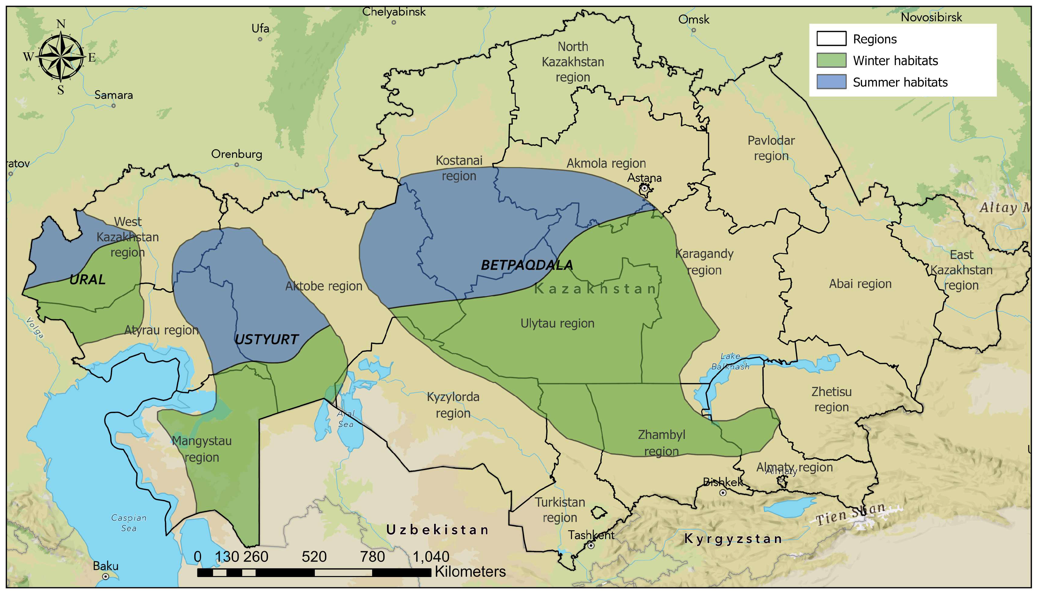
3.1. Description of Saiga Range in Kazakhstan
3.2. Analysis of Linear Transport Infrastructure in Saiga Range in Kazakhstan
4. Discussion
4.1. Description of Saiga Range in Kazakhstan
4.2. Influence of Linear Infrastructure on Saiga in Kazakhstan
4.2.1. Railways
4.2.2. Highways and Roads
5. Conclusions
Author Contributions
Funding
Institutional Review Board Statement
Data Availability Statement
Acknowledgments
Conflicts of Interest
Abbreviations
| CITES | Convention on International Trade in Endangered Species of Wild Fauna and Flora |
| CMS | Convention on Migratory Species of Wild Animals |
| CR | Critically endangered |
| E | East direction |
| GIS | Geographic Information System |
| GRIP | Global Roads Inventory Project |
| IUCN | International Union for Conservation of Nature |
| N | North direction |
| OSM | OpenStreetMap |
| QGIS | Quantum Geographic Information System |
| S | South direction |
| W | West direction |
Appendix A

References
- Sokolov, V.E.; Zhirnov, L.V. (Eds.) The Saiga Antelope: Phylogeny, Systematics, Ecology, Conservation and Use; Rosselkhozakademia Publ.: Moscow, Russia, 1998; 356p. (In Russian) [Google Scholar]
- Bekenov, A.B.; Grachev, I.A.; Milner-Gulland, E.J. The ecology and management of the Saiga antelope in Kazakhstan. Mammal Rev. 1998, 28, 1–52. [Google Scholar] [CrossRef]
- Grachev, J.A. Dynamics of the spatial structure of saiga populations in Kazakhstan. In Biological Diversity of Asian Steppes: Proceedings of the IV International Scientific Conference; Akhmet Baitursynuly Kostanay Regional University: Kostanay, Kazakhstan, 2022; pp. 123–127. (In Russian) [Google Scholar]
- Milner-Gulland, E.J.; Kholodova, M.; Bekenov, A.; Bukreeva, O.M.; Grachev, I.A.; Amgalan, L.; Lushchekina, A.A. Dramatic declines in saiga antelope populations. Oryx 2001, 35, 340–345. [Google Scholar] [CrossRef]
- Baydavletov, E.R.; Grachev, A.A.; Kantarbayev, S.S.; Saparbayev, S.K.; Baydavletov, R.Z.; Bekmanov, N.M.; Grachev, Y.A. Saiga monitoring in Kazakhstan in 2017. Saiga News 2017, 23, 19–23. [Google Scholar]
- Begilov, T.; Bizhanova, N.; Eszhanov, B.; Sarsenova, B. Current ecological state of the saiga population of the Vol-ga-Zhayk and problems of sustainable population development. Bulletin of KazNU. Ecol. Ser. 2024, 80, 58–67. (In Kazakh) [Google Scholar]
- Convention on Migratory Species (CMS). Overview Report on Conservation Status and MOU Implementation: Saiga Antelope; UNEP/CMS/Saiga/MOS4/Doc.5/Rev.2. In Proceedings of the Fourth Meeting of the Signatories to the Saiga MOU (MOS4), Online, 28–29 September 2021; Convention on Migratory Species (CMS): Bonn, Germany, 2021. [Google Scholar]
- Ito, T.Y.; Lhagvasuren, B.; Tsunekawa, A.; Shinoda, M. Habitat fragmentation by railways as a barrier to great migrations of ungulates in Mongolia. In Railway Ecology; van der Ree, R., Smith, D.J., Grilo, C., Eds.; Springer: Berlin/Heidelberg, Germany, 2017; pp. 229–246. [Google Scholar]
- Olson, K.A.; van der Ree, R. Railways, roads and fences across Kazakhstan and Mongolia threaten the survival of wide-ranging wildlife. In Handbook of Road Ecology; van der Ree, R., Smith, D.J., Grilo, C., Eds.; Wiley: Hoboken, NJ, USA, 2015; pp. 472–478. [Google Scholar]
- Milner-Gulland, E.J.; Bekenov, A.B.; Grachov, Y.A. The real threat to saiga antelopes. Nature 1995, 377, 488–489. [Google Scholar] [CrossRef]
- Sludskiy, A.A. Saiga in Kazakhstan. Proc. Inst. Zool. Acad. Sci. Kazakh SSR 1955, 4, 18–55. (In Russian) [Google Scholar]
- Fadeev, V.A.; Sludskiy, A.A. Saiga in Kazakhstan; “Nauka” of Kazakh SSR: Almaty, Kazakhstan, 1982; 160p. (In Russian) [Google Scholar]
- Fadeev, V.A.; Sludskiy, A.A. Saiga. In Mammals of Kazakhstan; “Nauka” of Kazakh SSR: Almaty, Kazakhstan, 1983; Volume 3, Part 3; pp. 56–927. (In Russian) [Google Scholar]
- Rakov, N.V. Experience of aerial visual census of large mammals in Central Kazakhstan. Zool. J. 1957, 36, 1403–1411. (In Russian) [Google Scholar]
- Sludskiy, A.A.; Shubin, I.G. Aerial visual census of saigas, goitered gazelles and resources of this game in the deserts of Kazakhstan. In Resources of the Fauna of Game Animals in the USSR and Their Census; Akademia Nauk SSSR: Moscow, Russia, 1963; p. 84. (In Russian) [Google Scholar]
- Methods of Account of the Main Game and Rare Species of Animals in Kazakhstan; Institute of Zoology MES RK: Almaty, Kazakhstan, 2003; pp. 46–54. (In Russian)
- Fadeev, V.A.; Ivanov, A.I. The number of Saiga tatarica in Kazakhstan and it’s dependence from the forage. In The Ecology and the Behavior of Mammals of Kazakhstan; “Nauka” of Kazakh SSR: Almaty, Kazakhstan, 1988; pp. 37–47. (In Russian) [Google Scholar]
- OpenStreetMap Foundation. OpenStreetMap Statistics. OpenStreetMap. Archived from the Original on 13 August 2021. 2021. Available online: https://www.openstreetmap.org (accessed on 15 April 2025).
- Meijer, J.R.; Huijbregts, M.A.J.; Schotten, K.C.G.J.; Schipper, A.M. Global patterns of current and future road infrastructure. Environ. Res. Lett. 2018, 13, 064006. [Google Scholar] [CrossRef]
- Pucha-Cofrep, F.; Fries, A. ArcGIS Pro Manual; Independently Publisher: Traverse City, MI, USA, 2025. [Google Scholar]
- QGIS Development Team. QGIS Geographic Information System, Open Source Geospatial Foundation Project. 2009. Available online: http://qgis.osgeo.org (accessed on 15 April 2025).
- Cai, X.; Wu, Z.; Cheng, J. Using kernel density estimation to assess the spatial pattern of road density and its impact on landscape fragmentation. Int. J. Geogr. Inf. Sci. 2013, 27, 222–230. [Google Scholar] [CrossRef]
- Shepard, D.B.; Kuhns, A.R.; Dreslik, M.J.; Phillips, C.A. Roads as barriers to animal movement in fragmented landscapes. Anim. Conserv. 2008, 11, 288–296. [Google Scholar] [CrossRef]
- Shivik, J.A.; Gese, E.M. Territorial significance of home range estimators for coyotes. Wildl. Soc. Bull. 2000, 28, 940–946. [Google Scholar]
- Singh, N.J.; Grachev, I.A.; Bekenov, A.B.; Milner-Gulland, E.J. Tracking greenery across a latitudinal gradient in central Asia – the migration of the saiga antelope. Divers. Distrib. 2010, 16, 663–675. [Google Scholar] [CrossRef]
- Salemgareyev, A.; Zuther, S. Saiga Antelope: Ustyurt, Kazakhstan. In Atlas of Ungulate Migration; Global Initiative on Ungulate Migration, Ed.; Convention on the Conservation of Migratory Species of Wild Animals: Bonn, Germany, 2024. [Google Scholar]
- Milner-Gulland, E.J.; Mallon, D.P. Saiga tatarica (Green Status assessment). In The IUCN Red List of Threatened Species; IUCN: Grann, Switzerland, 2024; p. e.T19832A1983220251. Available online: https://www.iucnredlist.org (accessed on 15 April 2025).
- IUCN; SSC Antelope Specialist Group. Saiga tatarica. In The IUCN Red List of Threatened Species; IUCN: Grann, Switzerland, 2023; p. e.T19832A233712210. [Google Scholar] [CrossRef]
- Committee for Forestry and Hunting of the Ministry of Agriculture of the Republic of Kazakhstan. Methodological Guidelines for Aerial Survey of Saigas in Kazakhstan (Order No. 191, August 23, 2005); Committee for Forestry and Hunting of the Ministry of Agriculture of the Republic of Kazakhstan: Astana, Kazakhstan, 2005. (In Russian)
- Wingard, J.; Zahler, P.; Victurine, R.; Bayasgalan, O.; Bayarbaatar, B. Guidelines for Addressing the Impact of Linear in-Frastructure on Large Migratory Mammals in Central Asia; Convention on the Conservation of Migratory Species of Wild Animals (CMS) Technical Report; UNEP/CMS Secretariat, Wildlife Conservation Society: Bonn, Germany, 2014. [Google Scholar]
- Government of the Republic of Kazakhstan. On the Introduction of a Ban on the Use of Saigas, Their Parts and Derivatives Throughout the Territory of the Republic of Kazakhstan, Except for Use for Scientific Purposes (Resolution No. 969, June 25, 2012); Government of the Republic of Kazakhstan: Astana, Kazakhstan, 2012. (In Russian)
- Ministry of Environment and Water Resources of the Republic of Kazakhstan. Order Dated April 4, 2014 No. 104-0; Ministry of Environment and Water Resources of the Republic of Kazakhstan: Astana, Kazakhstan, 2014. (In Russian)
- Ministry of Agriculture of the Republic of Kazakhstan. On Approval of the List of Valuable Animal Species That Are Objects of Hunting and Fishing (Order No. 18-03/106, February 16, 2015); Ministry of Agriculture of the Republic of Kazakhstan: Astana, Kazakhstan, 2015. (In Russian)
- Ministry of Agriculture of the Republic of Kazakhstan. On Approval of the Rules for Maintaining State Records, Cadastre and Monitoring of Wildlife (Order No. 18-03/577, June 26, 2015; Ministry of Agriculture of the Republic of Kazakhstan: Astana, Kazakhstan, 2015; Registered in the Ministry of Justice on 31 July 2015, No. 11800. (In Russian)
- Forestry and Wildlife Committee of the Ministry of Agriculture of the Republic of Kazakhstan. On the Introduction of Restrictions and Prohibitions on the Use of Wildlife, Their Parts and Derivatives, Establishing Places and Terms of Their Use (Order No. 190, July 24, 2015); Forestry and Wildlife Committee of the Ministry of Agriculture of the Republic of Kazakhstan: Nur-Sultan, Kazakhstan, 2015. (In Russian)
- Ministry of Agriculture of the Republic of Kazakhstan. On Approval of the Rules for Regulating the Number of Animals (Order No. 480, December 5, 2017); Ministry of Agriculture of the Republic of Kazakhstan: Astana, Kazakhstan, 2017. (In Russian)
- Luikart, G.; Amish, S.J.; Winnie, J.; Beja-Pereira, A.; Godinho, R.; Allendorf, F.W.; Harris, R.B. High connectivity among argali sheep from Afghanistan and adjacent countries: Inferences from neutral and candidate gene microsatellites. Conserv. Genet. 2011, 12, 921–931. [Google Scholar] [CrossRef]
- Abdybekova, A.M.; Zhaksylykova, A.A.; Kushaliyev, K.Z.; Kidiraliyev, E.Z.; Kozhayeva, A.R.; Kuzhebayeva, U.Z.; Grachev, A.; Shevtsov, A.; Budke, C.M. A survey of the parasites of Ural saiga antelopes and Turkmenian kulans of Kazakhstan. Int. J. Parasitol. Parasites Wildl. 2023, 21, 232–236. [Google Scholar] [CrossRef]
- Bizhanova, N.; Nanova, O.; Fadakar, D.; Grachev, A.; Hong, Z.; Sah, S.A.M.; Bizhanova, Z.; Sablin, M.; Grachev, Y. Insights into subspecies classification and conservation priorities of Central Asian lynx populations revealed by morphometric and genetic analyses. Sci. Rep. 2024, 14, 5186. [Google Scholar] [CrossRef]
- Grachev, A.; Grachev, Y.; Saparbayev, S.; Bespalov, M.; Baidavletov, Y.; Dzhanyspaev, A.; Riordan, P. Conservation of snow leopards in Kazakhstan. In Snow Leopards, 2nd ed.; McCarthy, T., Mallon, D., Nyhus, P., Eds.; Academic Press: Cambridge, MA, USA, 2024; pp. 471–480. [Google Scholar] [CrossRef]
- Moheb, Z.; Jahed, N.; Noori, H. Bactrian deer (Cervus elaphus bactrianus) still exist in Afghanistan. DSG Newsl. 2016, 28, 5–12.b. [Google Scholar]
- Brook, S.M.; Donnithorne-Tait, D.; Lorenzini, R.; Lovari, S.; Masseti, M.; Pereladova, O.; Ahmad, K.; Thakur, M. Cervus Hanglu (Amended Version of 2017 Assessment). In The IUCN Red List of Threatened Species; IUCN: Grann, Switzerland, 2017; p. e.T4261A120733024. [Google Scholar] [CrossRef]
- Xu, W.; Wang, M.; Blank, D.; da Silva, A.A.; Yang, W.; Ruckstuhl, K.E.; Alves, J. Goitered Gazelle Gazella subgutturosa Responded to Human Disturbance by Increasing Vigilance Rather than Changing the Group Size. Biology 2022, 11, 1236. [Google Scholar] [CrossRef]
- Dejid, N.; Olson, K.; Mueller, T. Mongolian Gazelle: Eastern Mongolia. In Atlas of Ungulate Migration; Global Initiative on Ungulate Migration, Ed.; Convention on the Conservation of Migratory Species of Wild Animals: Bonn, Germany, 2024. [Google Scholar]
- Luo, Z.; Jiang, Z.; Tang, S. Impacts of climate change on distributions and diversity of ungulates on the Tibetan Plateau. Ecol. Appl. 2015, 25, 24–38. [Google Scholar] [CrossRef]
- Kock, R.A.; Orynbayev, M.; Robinson, S.; Zuther, S.; Singh, N.J.; Beauvais, W.; Morgan, E.R.; Kerimbayev, A.; Khomenko, S.; Martineau, H.M.; et al. Saigas on the brink: Multidisciplinary analysis of the factors influencing mass mortality events. Sci. Adv. 2018, 4, eaao2314. [Google Scholar] [CrossRef]
- Beauvais, W.; Zuther, S.; Villeneuve, C.; Kock, R.; Guitian, J. Rapidly assessing the risks of infectious diseases to wildlife species. R. Soc. Open Sci. 2019, 6, 181043. [Google Scholar] [CrossRef]
- Milner-Gulland, E.J.; Bukreeva, O.M.; Coulson, T.; Lushchekina, A.A.; Kholodova, M.V.; Bekenov, A.B.; Grachev, I.A. Reproductive collapse in saiga antelope harems. Nature 2003, 422, 135. [Google Scholar] [CrossRef] [PubMed]
- Berger, J.; Buuveibaatar, B.; Mishra, C. Globalization of the Cashmere Market and the Decline of Large Mammals in Central Asia. Conserv. Biol. 2013, 27, 679–689. [Google Scholar] [CrossRef] [PubMed]
- Bhardwaj, M.; Olsson, M.; Håkansson, E.; Söderström, P.; Seiler, A. Ungulates and trains – Factors influencing flight responses and detectability. J. Environ. Manag. 2022, 313, 114992. [Google Scholar] [CrossRef] [PubMed]
- Clair, C.C.S.; Whittington, J.; Forshner, A.; Gangadharan, A.; Laskin, D.N. Railway mortality for several mammal species increases with train speed, proximity to water, and track curvature. Sci. Rep. 2020, 10, 20476. [Google Scholar] [CrossRef]
- Shi, F.; Liu, S.; An, Y.; Sun, Y.; Zhao, S.; Liu, Y.; Li, M. Climatic factors and human disturbance influence ungulate species distribution on the Qinghai-Tibet Plateau. Sci. Total Environ. 2023, 869, 161681. [Google Scholar] [CrossRef]
- Grachev, Y.A. Distribution of saiga. In National Atlas of the Republic of Kazakhstan. Vol. I: Natural Conditions and Resources; VIT BRAND LLP: Almaty, Kazakhstan, 2010; pp. 469–476. (In Russian) [Google Scholar]
- Singh, N.; Grachev, I.; Bekenov, A.; Milner-Gulland, E. Saiga antelope calving site selection is increasingly driven by human disturbance. Biol. Conserv. 2010, 143, 1770–1779. [Google Scholar] [CrossRef]
- Salemgareev, A.; Shaimukhanbetov, O.; Zuther, S.; Sklyarenko, S. Results of the satellite collaring programme in Betpak-dala, 2009/10. Saiga News 2011, 12, 11–12. [Google Scholar]
- Zuther, S. Barriers as a threat to saiga migration in Kazakhstan. Saiga News 2014, 18, 1–3. [Google Scholar]
- Olsson, M.P.O.; Widen, P. Effects of highway fencing and wildlife crossings on moose Alces alces movements and space use in southwestern Sweden. Wildl. Biol. 2008, 14, 111–117. [Google Scholar] [CrossRef]
- Fahrig, L.; Rytwinski, T. Effects of Roads on Animal Abundance: An Empirical Review and Synthesis. Ecol. Soc. 2009, 14, 21. [Google Scholar] [CrossRef]
- Farfán, M.A.; Fa, J.E.; Martín-Taboada, A.; García-Carrasco, J.M.; Duarte, J. Lack of maintenance of motorway fences works against their intended purpose with potential negative impacts on protected species. Sci. Rep. 2020, 10, 791. [Google Scholar] [CrossRef] [PubMed]
- Obozov, N.A.; Savelyev, A.T.; Belevtseva, O.V.; Fortunatov, I.K. Secondary Uses in the Forests of the USSR; Lesnaya Promyshlennost’: Moscow, Russia, 1971; 152p. (In Russian) [Google Scholar]
- Abaturov, B.D.; Dzapova, R.R. Forage availability to saigas (Saiga tatarica) and their state on steppe pastures with a different ratio of graminoid plants and forbs. Biol. Bull. 2015, 42, 163–170. (In Russian) [Google Scholar] [CrossRef]
- Makulbekov, M. Saigas vs. Farmers: Battle for Pastures. 2024. Available online: https://www.inform.kz/ru/kak-mozhno-reshit-vopros-s-saygakami-v-zapadno-kazahstanskoy-oblasti-17190c (accessed on 15 May 2025). (In Russian).
- Tucker, M.A.; Böhning-Gaese, K.; Fagan, W.F.; Fryxell, J.M.; Van Moorter, B.; Alberts, S.C.; Ali, A.H.; Allen, A.M.; Attias, N.; Avgar, T.; et al. Moving in the Anthropocene: Global reductions in terrestrial mammalian movements. Science 2018, 359, 466–469. [Google Scholar] [CrossRef] [PubMed]
- Forman, R.T.; Sperling, D.; Bissonette, J.A.; Clevenger, A.P.; Cutshall, C.D.; Dale, V.H.; Fahrig, L.; France, R.; Goldman, C.R.; Heanue, K.; et al. Road Ecology: Science and Solutions; Island Press: Washington, DC, USA, 2003; 482p. [Google Scholar]
- Zuther, S. Saiga populations in Kazakhstan continue growing. Saiga News 2025, 30, 17–18. [Google Scholar]
- Benítez-López, A.; Alkemade, R.; Verweij, P.A. The impacts of roads and other infrastructure on mammal and bird populations: A meta-analysis. Biol. Conserv. 2010, 143, 1307–1316. [Google Scholar] [CrossRef]
- Xia, L.; Yang, Q.; Li, Z.; Wu, Y.; Feng, Z. The effect of the Qinghai-Tibet railway on the migration of Tibetan antelope Pantholops hodgsonii in Hoh-xil National Nature Reserve, China. Oryx 2007, 41, 352–357. [Google Scholar] [CrossRef]
- Sawyer, H.; Kauffman, M.J.; Middleton, A.D.; Morrison, T.A.; Nielson, R.M.; Wyckoff, T.B.; Pettorelli, N. A framework for understanding semi-permeable barrier effects on migratory ungulates. J. Appl. Ecol. 2013, 50, 68–78. [Google Scholar] [CrossRef]
- Zhang, B.; Tang, J.; Wang, Y.; Zhang, H.; Wu, D.; Xu, G.; Lin, Y.; Wu, X. Designing wildlife crossing structures for ungulates in a desert landscape: A case study in China. Transp. Res. Part D Transp. Environ. 2019, 77, 50–62. [Google Scholar] [CrossRef]
- Sultan, H.; Rashid, W.; Shi, J.; Rahim, I.U.; Nafees, M.; Bohnett, E.; Rashid, S.; Khan, M.T.; Shah, I.A.; Han, H.; et al. Horizon Scan of Transboundary Concerns Impacting Snow Leopard Landscapes in Asia. Land 2022, 11, 248–269. [Google Scholar] [CrossRef]
- Naboureh, A.; Bian, J.; Lei, G.; Li, A. A review of land use/land cover change mapping in the China-Central Asia-West Asia economic corridor countries. Big Earth Data 2021, 5, 237–257. [Google Scholar] [CrossRef]
- Huang, M.-X.; Li, S.-Y. The analysis of the impact of the Belt and Road initiative on the green development of participating countries. Sci. Total Environ. 2020, 722, 137869. [Google Scholar] [CrossRef]
- Lechner, A.M.; Chan, F.K.S.; Campos-Arceiz, A. Biodiversity conservation should be a core value of China’s Belt and Road Initiative. Nat. Ecol. Evol. 2018, 2, 408–409. [Google Scholar] [CrossRef] [PubMed]
- Ascensão, F.; Fahrig, L.; Clevenger, A.P.; Corlett, R.T.; Jaeger, J.A.G.; Laurance, W.F.; Pereira, H.M. Environmental challenges for the Belt and Road Initiative. Nat. Sustain. 2018, 1, 206–209. [Google Scholar] [CrossRef]
- Mysłajek, R.W.; Olkowska, E.; Wronka-Tomulewicz, M.; Nowak, S. Mammal use of wildlife crossing structures along a new motorway in an area recently recolonized by wolves. Eur. J. Wildl. Res. 2020, 66, 79. [Google Scholar] [CrossRef]
- Myrzakhmetov, B.; Akhmetova, A.; Bissenbay, A.; Karibayev, M.; Pan, X.; Wang, Y.; Bakenov, Z.; Mentbayeva, A. Chitosan-Based Biopolymers for Anion-Exchange Membrane Fuel Cell Application. R. Soc. Open Sci. 2023, 10, 230843. [Google Scholar] [CrossRef]
- Corlatti, L.; Hackländer, K.; Frey-Roos, F. Ability of wildlife overpasses to provide connectivity and prevent genetic isolation. Conserv. Biol. 2009, 23, 548–556. [Google Scholar] [CrossRef]
- Simpson, N.O.; Stewart, K.M.; Schroeder, C.; Cox, M.; Huebner, K.; Wasley, T. Overpasses and underpasses: Effectiveness of crossing structures for migratory ungulates. J. Wildl. Manag. 2016, 80, 1370–1378. [Google Scholar] [CrossRef]
- Spellerberg, I.F. Ecological Effects of Roads; The Land Reconstruction and Management Series; Science Publishers, Inc.: Hauppauge, NY, USA; Volume 2. [CrossRef]
- Olsson, M.P.; Widén, P.; Larkin, J.L. Effectiveness of a highway overpass to promote landscape connectivity and movement of moose and roe deer in Sweden. Landsc. Urban Plan. 2008, 85, 133–139. [Google Scholar] [CrossRef]
- Alexander, S.M. Snow-tracking and GIS: Using multiple species-environment models to determine optimal wildlife crossing sites and evaluate highway mitigation plans on the Trans-Canada Highway. Can. Geogr. Can. 2008, 52, 169–187. [Google Scholar] [CrossRef]
- Sawyer, H.; Rodgers, P.A.; Hart, T. Pronghorn and mule deer use of underpasses and overpasses along U.S. Highway 191. Wildl. Soc. Bull. 2016, 40, 211–216. [Google Scholar] [CrossRef]
- Brennan, L.; Chow, E.; Lamb, C. Wildlife overpass structure size, distribution, effectiveness, and adherence to expert design recommendations. PeerJ 2022, 10, e14371. [Google Scholar] [CrossRef]
- Kazdor, N., II; Sapa, S.Z.; Saen, C.R.; Mid, R.K. Final Report of EIASS on Centre-West Road Project: Astana–Arkalyk–Turgai–Irgiz–Shalkar Road Section; Committee for Roads, Ministry of Investment and Development of the Republic of Kazakhstan: Nur-Sultan, Kazakhstan, 2016; 175p.


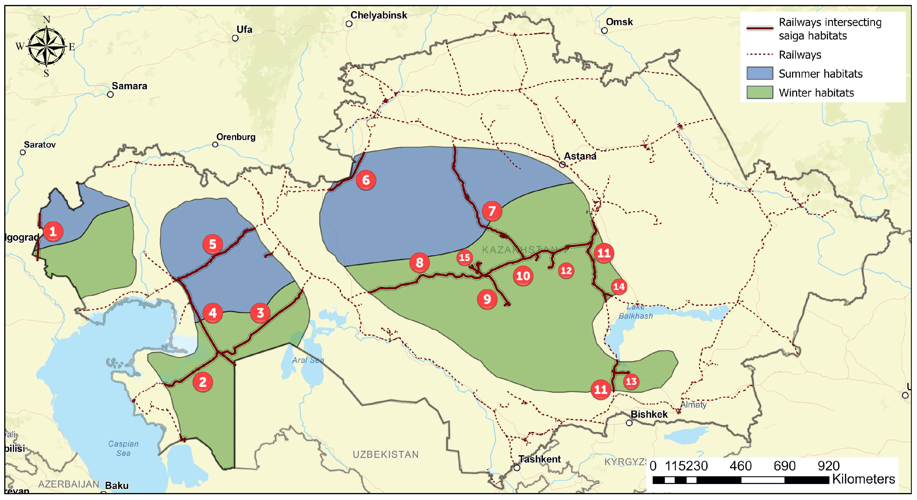
| Populations | Railways | |||||
|---|---|---|---|---|---|---|
| Name | Length, km | Direction, North (N), East (E), South (S), West (W) | Habitat Intersection | Degree of Negative Influence | Infrastructure Density, km/100 km2 | |
| Ural | Saratov– Astrkhan | 137.3 | N–S | Westernmost area: partially winter and summer habitats | Low | 0.128 |
| Subtotal | 137.3 | 0.128 | ||||
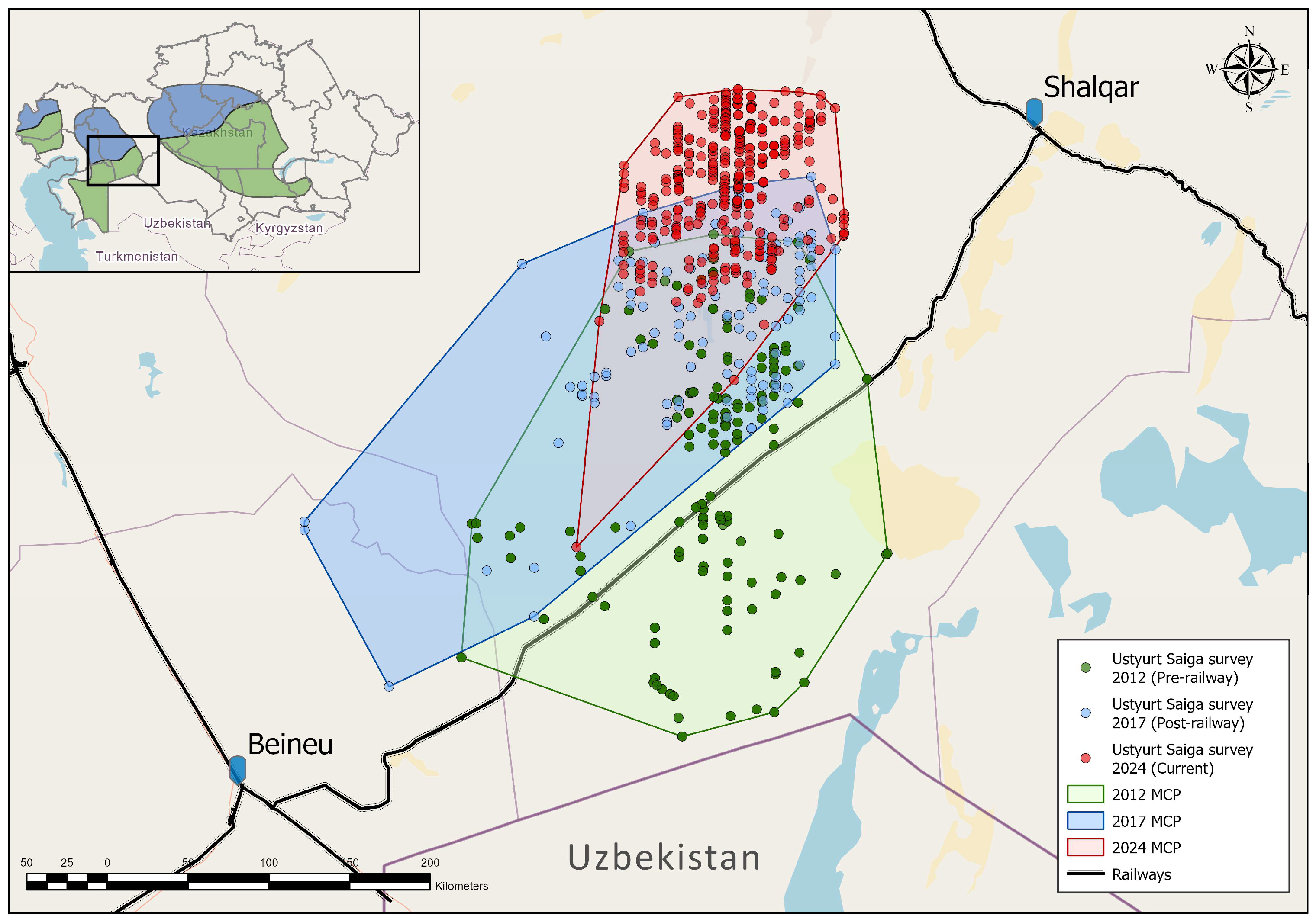
| Ustyurt | Beineu–Aqtau | 280 | NE–SW | Southwest area: winter habitats | Medium | |
| Beineu–Shalqar | 440 | NE–SW | Winter habitats: significantly cuts off migration route to winter habitats (including Uzbekistan) | High | ||
| Maqat– Turkmenabat | 434 | N–S | Westernmost area: partial winter and summer habitats | Low–medium (more clarification needed) | ||
| Qandyagash– Atyrau | 482.4 | NE–SW | Summer habitats | High | ||
| Subtotal | 1636.4 | 0.55 | ||||
| Betpaqdala | Khromtau– Qostanay | 198.7 | NE–SW | Northwestern area: summer habitats | Low | |
| Esil–Kyzylzhar | 510 | N–S | Divides the population into distinct eastern and western population groups | High | ||
| Zhezqazgan– Sekseuildi | 462.7 | E–W | Winter habitats: significantly cuts off migration route to winter habitats | High | ||
| Zhezqazgan–Aibat | 130 | N–S | Central area, located in winter habitats | Medium | ||
| Zharyk–Zhesqazgan | 443.14 | E–W | Winter habitats: significantly cuts off migration route to winter habitats | High | ||
| Qaraghandy– Shu | 447.9 | N–S | East and southeast areas: winter habitats | Medium | ||
| Qarazhal | 70.6 | N–S | Central area, located in winter habitats | Medium | ||
| Aqsuiek | 61.6 | E–W | Southeast area: winter habitats | Medium | ||
| Moiynty– Balkhash | 31.1 | NW–SE | Eastern area: winter habitats | Low | ||
| Zhezqazgan internal | 118.1 | N–S | Central area, located in winter habitats | Medium | ||
| Subtotal | 2247.84 | 0.342 | ||||
| TOTAL | 4021.54 | 0.378 | ||||
| Road Type | Betpaqdala, km | Betpaqdala, Infrastructure Density, km/100 km2 | Ural, km | Ural, Infrastructure Density, km/100 km2 | Ustyurt, km | Ustyurt, Infrastructure Density, km/100 km2 |
|---|---|---|---|---|---|---|
| Path, i.e., | 172.0478027 | 0.02616 | 308.5592 | 0.286797 | 93.92054 | 0.031602 |
| summer habitats | 15.44823413 | 0.00689 | 7.0650844 | 0.018471 | 2.1525464 | 0.001641 |
| winter habitats | 156.59956854 | 0.03634 | 35.981423 | 0.054511 | 91.767998 | 0.058113 |
| Primary, i.e., | 1741.837165 | 0.264847 | - | 0 | 508.1813 | 0.170993 |
| summer habitats | 713.5166390 | 0.31837 | - | 0 | 1156.3330 | 0.88162 |
| winter habitats | 1028.001603 | 0.23858 | - | 0 | - | 0 |
| Residential, i.e., | 2581.978515 | 0.392591 | 719.3635 | 0.668628 | 1285.733 | 0.432624 |
| summer habitats | 1156.333099 | 0.51596 | 497.38299 | 1.300415 | 960.40188 | 0.732237 |
| winter habitats | 1428.3004516 | 0.33148 | 153.77575 | 0.232968 | 325.09546 | 0.205871 |
| Secondary, i.e., | 2549.672958 | 0.387679 | 488.7311 | 0.454262 | 425.787 | 0.143269 |
| summer habitats | 1020.8328 | 0.455501 | 457.76452 | 1.196832 | 404.2399 | 0.308203 |
| winter habitats | 1517.706030 | 0.352231 | - | 0 | 21.547093 | 0.013645 |
| Service, i.e., | 3245.201358 | 0.493435 | 71.78363 | 0.066721 | 1925.295 | 0.647824 |
| summer habitats | 1304.492315 | 0.582071 | 25.146703 | 0.065746 | 1148.0225 | 0.875284 |
| winter habitats | 1942.7043969 | 0.450866 | 25.314717 | 0.038351 | 729.50831 | 0.461971 |
| Tertiary, i.e., | 6057.923224 | 0.921111 | 968.8612 | 0.900529 | 1803.744 | 0.606925 |
| summer habitats | 2366.036218 | 1.055738 | 376.51739 | 0.984411 | 1450.1803 | 1.105657 |
| winter habitats | 3691.685269 | 0.856772 | 532.03946 | 0.806035 | 353.43203 | 0.223816 |
| Track, i.e., | 13,505.43834 | 2.053509 | 8621.897 | 8.013809 | 11,455.43 | 3.854528 |
| summer habitats | 4203.112250 | 1.875451 | 550.51227 | 1.439323 | 5575.8501 | 4.251182 |
| winter habitats | 9229.787567 | 2.142063 | 4685.456 | 7.098423 | 5781.098 | 3.660962 |
| Steppe track, i.e., | 1047.458603 | 0.159267 | - | 0 | 914.471 | 0.307702 |
| summer habitats | 473.1846065 | 0.211137 | - | 0 | 426.37863 | 0.325083 |
| winter habitats | 574.2739896 | 0.133278 | - | 0 | 468.9296 | 0.296956 |
| Trunk, i.e., | 1504.70543 | 0.228791 | - | 0 | 719.565 | 0.24212 |
| summer habitats | 420.0208878 | 0.187415 | - | 0 | 233.54176 | 0.17806 |
| winter habitats | 1084.693935 | 0.251737 | - | 0 | 469.22363 | 0.29714 |
| Unclassified, i.e., | 10,257.96337 | 1.559729 | 2742.175 | 2.548774 | 4709.833 | 1.584767 |
| summer habitats | 3576.625473 | 1.595909 | 1395.8204 | 3.649394 | 2924.0176 | 2.229351 |
| winter habitats | 6682.388006 | 1.550859 | 913.13843 | 1.383396 | 1774.2123 | 1.123545 |
| Subtotal, summer habitats | 15,249.60252 | 6.804456 | 3310.2093 | 8.654594 | 14,281.118 | 10.888318 |
| Subtotal, winter habitats | 27,336.14081 | 6.344214 | 6345.7057 | 9.613686 | 10,014.814 | 6.342022 |
| TOTAL | 42,664.22677 | 6.487119 | 13,921.37 | 12.93952 | 23,841.96 | 8.022354 |
Disclaimer/Publisher’s Note: The statements, opinions and data contained in all publications are solely those of the individual author(s) and contributor(s) and not of MDPI and/or the editor(s). MDPI and/or the editor(s) disclaim responsibility for any injury to people or property resulting from any ideas, methods, instructions or products referred to in the content. |
© 2025 by the authors. Licensee MDPI, Basel, Switzerland. This article is an open access article distributed under the terms and conditions of the Creative Commons Attribution (CC BY) license (https://creativecommons.org/licenses/by/4.0/).
Share and Cite
Bizhanova, N.; Grachev, A.; Rametov, N.; Baidavletov, Y.; Saparbayev, S.; Bespalov, M.; Bespalov, S.; Kumayeva, I.; Toishibekov, Y.; Khamchukova, A.; et al. Railway and Road Infrastructure in Saiga Antelope Range in Kazakhstan. Diversity 2025, 17, 431. https://doi.org/10.3390/d17060431
Bizhanova N, Grachev A, Rametov N, Baidavletov Y, Saparbayev S, Bespalov M, Bespalov S, Kumayeva I, Toishibekov Y, Khamchukova A, et al. Railway and Road Infrastructure in Saiga Antelope Range in Kazakhstan. Diversity. 2025; 17(6):431. https://doi.org/10.3390/d17060431
Chicago/Turabian StyleBizhanova, Nazerke, Alexey Grachev, Nurkuisa Rametov, Yerlik Baidavletov, Saltore Saparbayev, Maxim Bespalov, Sergey Bespalov, Indira Kumayeva, Yerzhan Toishibekov, Anna Khamchukova, and et al. 2025. "Railway and Road Infrastructure in Saiga Antelope Range in Kazakhstan" Diversity 17, no. 6: 431. https://doi.org/10.3390/d17060431
APA StyleBizhanova, N., Grachev, A., Rametov, N., Baidavletov, Y., Saparbayev, S., Bespalov, M., Bespalov, S., Kumayeva, I., Toishibekov, Y., Khamchukova, A., & Grachev, Y. (2025). Railway and Road Infrastructure in Saiga Antelope Range in Kazakhstan. Diversity, 17(6), 431. https://doi.org/10.3390/d17060431