Abstract
This paper aims to assess land use and land use change (LULC). For this purpose, supervised mapping on satellite imagery, using the European Space Agency (ESA) SNAP programme from LANDSAT databases, publicly accessible through the European Copernicus portal, was used. At the same time, an analysis of the degree of landscape fragmentation in the study area was carried out, which revealed that, because of the particular fragmentation of small polygons, the best results were obtained via analysis/supervised mapping on satellite images. This method, once validated in the field, reflects the most accurate land use pattern in the analysed area, with wide applications in studies of agriculture, biodiversity, geography, etc. Between 2000 and 2010, significant changes were registered. Artificial surfaces decreased by approximately 400 ha, showing a negative trend in the last period of the interval. Coniferous forests reached their maximum threshold in 2000 (with 114,400 ha) in conjunction with the “Grassland” class, which exceeded 16,700 ha. In 2010, a drastic decrease in “Grassland” was recorded, reaching half of the values of 1990 and 2000, now having only 15,684 ha. Land cover changes were significant when comparing the period before 1989 with 2021. This fact was due to socio-economic changes in society, in large part caused by changes in professions and the way of life of the population.
1. Introduction
Landscapes across the globe are increasingly subject to alteration by humans, with the associated land use and land cover changes having considerable consequences for biodiversity [1,2,3]. In human-dominated landscapes, the survival of faunal species can depend on habitat connectivity [4]. Vegetation is an essential component of Earth’s terrestrial ecosystems since it serves as a bridge connecting the soil, water, and atmosphere. Forest carbon sinks are an important potential solution to global climate change, and the absorption of carbon dioxide can be enhanced by protecting and restoring vegetation [5,6].
Land use and land use change (LULC) is one of the main changes observed on the Earth’s surface and is of real interest in terms of social, economic, and environmental consequences [7]. The Earth’s surface is constantly changing, not only through its natural dynamics but also because of anthropogenic activity, affecting both ecosystems and human beings [8]. These changes in land use/land cover are considered to be accelerated and widespread processes [9]. LULC is not only one of the most important environmental and global concerns but also a key driver of global change through interactions with ecological processes, climates, biogeochemical cycles, biodiversity, and climate change [9].
Land use conversion and change can have negative impacts on soil, vegetation, water, and air at local and regional scales, and through cumulative effects, the quality of these factors globally undergoes significant degradation processes [10]. Understanding and anticipating the causes, processes, and consequences of land use/land cover change has become a major challenge for landscape ecology, regional land use (LU) planning, biodiversity conservation, and the protection of clean water resources [7]. Along with these, land cover analysis is divided into two levels, namely, detecting where land use class typology change phenomena occur and quantitatively defining the rate of change from a temporal perspective. Starting from the intersection between the spatial side of changes and their temporal side, an important resonance in the methodological spectrum is provided by remote sensing and the Geographic Information System (GIS), which are the best methods to study the spatial distribution and evolution of the geographical phenomena of land use and land cover changes [10]. Moreover, with the help of integrated GIS platforms, it is possible to create a database through which spatial processes in a given area can be analysed in order to determine quantitative and qualitative parameters, thus monitoring various environmental processes (“over-harvesting”, major deforestation, accidental wind damage, etc.) and/or potential vulnerabilities [11]. Satellite imagery can provide information on various climatic phenomena or different forms of pollution, the most widespread use of which is related to land cover/land use [12].
The Landsat program is the oldest Earth satellite imagery acquisition program, a joint NASA/USGS program launched on 23 July 1972. Using these Landsat image processing data, changes in the overall landscape are defined with highly applicable mapping materials in various fields, which are intended to contribute decisively to the shaping of environmental indicators and the planning and management of natural resources, but at the same time, they can support decisionmakers [13].
In this field, regarding the study of the dynamics of land use, there have been no in-depth studies in this area, with evaluations being based on specific observations in the field and only in areas of economic interest. This fact is one of the novelty elements of this article. This area is extremely understudied; we have already referred to some works in this area that have the use of land as their object of study, but there are very few. It is this work that we hope will bring a series of new elements that can be cited in the future regarding this mountain area. Through this work, we offer a realistic evaluation based on the study of the area, eliminating the economic factor, and showing the evolution of land use over a period of time with major changes in the way of life of the population, which directly influenced the natural environment of this area.
2. Materials and Methods
The aim of the project is to obtain new relevant information on the spatial and temporal dynamics of land use and land cover in the mountain areas of the Eastern Carpathians as a basis for strategic directions and environmental policies in order to ensure the sustainable development of mountain areas in the current context of environmental and societal changes.
The main objectives of this research project are the following important aspects:
Land use/land cover dynamics in the upper part of the Bistrița river basin in the period 1990–2021 based on Landsat images.
The detection of land use change in the upper part of the Bistrița catchment in the period of 1990–2021, and the impact on landscape structure indicators.
Our analysis of the spatial dynamics of land use and land cover focused on the upper basin of the Bistrița River, a mountainous area representative of the Carpathian space, located in the northern part of the Eastern Carpathians (Figure 1a,b). The study area, with a total area of 182,877 ha, is characterized by a diversity of land cover and land use, with all types of categories specific to the mountainous area of the Carpathians. Thus, the position of the studied area provides it with a unique character and, at the same time, is representative of an intra-Carpathian mountain area. Located at the interference zone between the Atlantic and Continental climatic zones, over which a specific mountain depression climate is superimposed, land use changes from this area will become a landmark when future studies analyse major land use and landscape changes in the Eastern Carpathians.
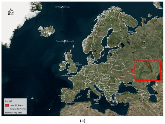
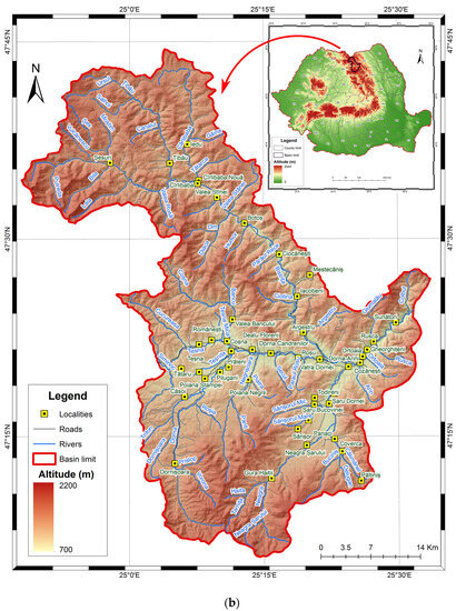
Figure 1.
(a) Spatial location of the upper basin of Bistrița in Europe. (b) Hypsometric map and spatial location of the upper basin of Bistrița in Romania.
Another defining aspect of the study area is the diversity of the forms of ownership of agricultural and forest land, which imposes a specific land use dynamic. The altitudinal difference ranges from 700 to 2200 metres, with the higher areas converging with the central area, which has lower altitudes and significant fragmentation. The network of valleys is dense and tributary to the Bistrița River, with a relatively homogeneous and balanced distribution, mainly oriented W-E and NW-SE, and a total length of 646.08 km, and the average density of the hydrographic network is 0.35 km/km2. The compartment used in our study is mostly an intra-montane corridor with a narrow valley and a high depressional area [14].
The thematic mapping of the biophysical cover can be viewed from two perspectives, namely, land cover, which is represented by information on various types of physical cover on the land surface (e.g., forests, grasslands, crops, water bodies, wetlands, etc.), and land use maps, which contain spatial information on the methods of organization and anthropogenic arrangement in a given class [15], or, in other words, it refers to the socio-economic function provided by the uses of each area (e.g., agriculture, etc.) [11].
Satellite observations can provide globally consistent and repetitive measurements of the Earth’s surface conditions, returning important data with different spatial, spectral, radiometric, and temporal resolutions. They are extremely useful for monitoring the spatial distribution and growth of urban built-up areas because of their ability to provide timely and synoptic views of land cover [16].
Detecting and quantifying land cover changes in mountainous areas based on satellite images represent the main aims of some studies. Knowing these changes is useful for forest and pasture management in protected areas. Also, landscape ecology has developed quantitative indices, on the basis of which the landscape pattern can be depicted and analysed [17]. The images used are Landsat 1 for 1990, Landsat 5 for 2000, Landsat 7 for 2010, and Landsat 8 for 2021. These satellite images were downloaded and processed using the SNAP software (ESA SNAP 9.0.0) produced by the ESA (European Space Agency). These images were chosen to have as little cloud coverage as possible (less than 10%), in which case, the processing can be at a high level of accuracy. Different Landsat products were chosen because of the lack of spatial–temporal coverage based on the needs of the study area (Table 1). After processing, the data were imported into ArcMap.

Table 1.
Landsat product information.
The vector dataset was processed and delineated for the study area by applying specific GIS algorithms in the ArcGIS software (ArcGis 10.1 for desktop), for which the number of classes was reduced. Thus, the delineation of the four classes “bareland/settlements”, “grassland”, “bush”, and “forest” was achieved, as shown in Table 2.

Table 2.
Class categories.
3. Results
3.1. Land Cover Dynamics over the Period 1990–2021
The analysis carried out allowed for the identification of a specific dynamic in terms of land cover changes in the upper basin of the Bistrița River, mainly determined by using the restitution of forest property processes in conjunction with a reduction in agricultural activities specific to the mountain area. A spatial analysis of the land cover shows a concentration of agricultural land, especially in the Dorna Depression. The location of artificial surfaces, that is, urban and rural inhabited areas, is usually along the main rivers draining into the upper basin of the Bistrița. In terms of degraded land, i.e., land covered with rubbish dumps or mining operations, the former sulphur mines in the Călimani Mountains (i.e., the stone quarries at Saru Dornei, Dornișoara, Cârlibaba, and Ciocănești) stand out.
Forests, especially coniferous ones, are dominant in the upper basin of the Bistrița River, with a dominant spatial distribution in the northern and western parts of the study area. The woodlands are mainly spread in the upper mountainous area at altitudes above 1200 m, with the most notable being those in the Rodna Mountains and the Maramureș Mountains. Visual analysis of the spatial maps shows an increase in the degree of fragmentation in land cover types linked to two main factors: the high quality and resolution of the satellite images used in recent years, which allow for a better interpretation of land cover, and the changes that have occurred in forest categories and transition zones between forests and shrub vegetation (Figure 2a,b).
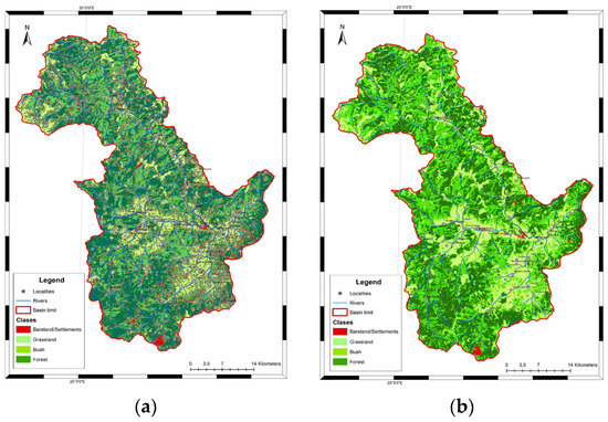
Figure 2.
(a) Land cover for the Upper Bistrița Basin—1990; (b) land cover for the Upper Bistrița Basin—2000.
In terms of the spatial distribution of changes between the different land cover categories, for the period 1990–2021, there was a predominance of transition between forest (coniferous or mixed) and transitional or shrub vegetation.
Analysing the spatial distribution, there is a concentration in two main areas: the northern area of the basin upstream of Cârlibaba, mainly explained by the high frequency of windfalls and the application of forest management plans (clear-cutting in small areas), and the southeastern area downstream of Vatra Dornei. In the second situation, the processes of felling and exploiting the forest in relatively large and compact areas are linked to the process of forest land retrocession to former owners. In the first decade after the first property laws were applied, the processes of uncontrolled felling in private forests characterized the social and economic dynamics of the Dorna Basin (part of the Upper Bistrița River Basin).
In the period 2000–2010 (Figure 3a), 95% of the land cover changes were represented by a shift from forest to shrub vegetation, spatially distributed mainly in two areas: the Țibău–Șesuri Basin and the Dorna Basin. This process of land cover change can be explained by the high incidence of windthrow in forests (e.g., 2002) in the northern part of the study area, particularly by the continuing process of forest land restitution [18].
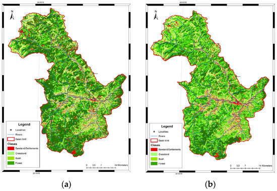
Figure 3.
(a) Land cover for the Upper Bistrița Basin—2010; (b) land cover for the Upper Bistrița Basin—2021.
Catastrophic windthrow in forests, which affected large areas of the Eastern Carpathians in 2006–2012 (e.g., 2007), is still the main driver of forest cover change in the Upper Bistrița Basin (forests in shrublands). The northern area, in particular, the upper basin of the Țibău, stands out. Here, in addition to the natural disturbance factor represented by wind, the negative influence of the anthropic factor caused by the illegal logging of large areas of the forest is becoming increasingly evident. There is also an increase in the area of regeneration, both natural and artificial, as a result of logging processes, particularly in Coșna–Bancu and Argestru.
The last decade is characterised by a diversification of changes between the different land cover categories because of an increase in the accuracy of satellite image classifications. This fact was caused by a significant increase in the resolution of the images used (Landsat). The areas occupied by forests continued to decrease, and those in the transition zone between forest and shrub vegetation increased, especially in the northern part of the study area (Țibău–Șesuri Basin) (Figure 3b). It should be noted that, even if there is a change in land cover along with a change in forest class, these areas remain in the forest background and are subject to regeneration processes.
It Is expected that, in the next decade, there will be a significant increase in the reversal of changes from forest–shrub transition areas to the forest class because of the regeneration of these areas, affected in the past by windthrow in the forest floor or uncontrolled felling.
All these land cover changes were detected because of the increased classification accuracy of satellite images, i.e., actual changes due to anthropogenic intervention or non-intervention in conjunction with the actions of disturbance factors that cause landscape changes. Landscape characterisation can be achieved via metric indicators that reflect landscape texture, i.e., the size of the different land cover classes, the size of the edges between the different classes, or their connectivity [19].
It can be observed In the land cover dynamics of the study area that the area is characterized by a decrease in areas used for agriculture and an equivalent increase in the forest category. Areas with semi-natural vegetation indicate a significant reduction in agricultural activities specific to the mountain area in conjunction with the abandonment of land and, especially, mountain pastures (Figure 4a,b and Figure 5a,b).
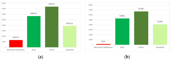
Figure 4.
Evolution of land cover classes: (a) 1990; (b) 2000.
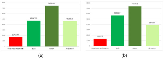
Figure 5.
Evolution of land cover classes: (a) 2010; (b) 2021.
For the year 2021, a roughly equal proportion of grassland forest can be observed, and tree vegetation (shrubs) decreased in favour of unvegetated land, without being included in the agricultural circuit. This can be explained by the increase in living space and the extension of the road network (Figure 5b).
A spatial analysis of the land cover, especially of the changes between the different classes, highlights the particularities induced by the ownership regime, especially the risk areas, in terms of disturbing factors (e.g., windthrow) (Table 3).

Table 3.
Class areas (ha).
For the period 2000–2010, the rate of change in land use/cover increased significantly by 3.7% per year. Regarding the transition between land use/cover classes, both the conversion of forests into grasslands (Figure 6a,b) and grasslands into forests and arable land (Figure 7a) can be observed. Also, associations of vegetation and/or herbaceous species transform into forests, for example, pastures into arable land and built-up areas (Figure 7b). On the other hand, the conversion of permanent crops and complex agricultural crops into grasslands or grasslands into complex agricultural crops and heterogeneous agricultural crops registered a rather small share (percentage).

Figure 6.
(a) Forest; (b) grassland.
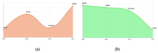
Figure 7.
(a) Bareland/settlements; (b) bush.
3.2. Individual Evolution of Land Use Classes
The year 1990 represents an important stage in the attempt to establish how land use has changed in the last three decades; not only is it a point of reference but it is also a methodological impasse because the quality of the data has subsequently improved. The “bareland/settlements” class shows significantly higher values in 1990 and 2000. The major changes in this period (Figure 8) appear at the level of “grassland”, with differences of 272 ha. Modest changes also appear at the level of agricultural land with a decrease in complex crops (140 ha) and a slight reduction in coniferous forests compared with the total value (1036 ha) (Figure 9).
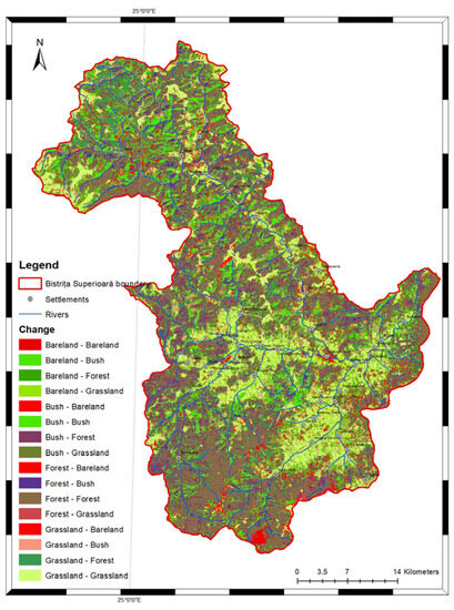
Figure 8.
Land cover changes in the Upper Bistrița Basin, 1990–2021.
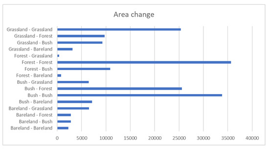
Figure 9.
Land cover changes in the Upper Bistrița Basin, 1990–2021 (ha).
In the overall combined classes, the changes from 1990 to 2000 are minor, the percentages of the total being superficially affected (Table 3). In the time interval 2000–2010, significant changes are registered, both individually and by combining the classes. Artificial surfaces decreased by approximately 400 ha, showing a negative trend in the last period of the interval and increasing the share of non-irrigated arable land, previously included in another category; the pattern of mixed crops was significantly modified by these changes. Coniferous forests reached their maximum threshold in 2000 (with 114,400 ha) in conjunction with the “grassland” class, which exceeded 16,700 ha. At the same time, in 2010, a drastic decrease in “grassland” was recorded, reaching half the value of 1990 and 2000, now with only 15,684 ha (Table 3).
4. Discussion
In Romania, research based on remote sensing has identified changes in land use for the post-communist period, corroborating various satellite data sources (Landsat, Sentinel) and analysis methods. Thus, in the case of Romania, it was concluded that land use has undergone major changes [19]. These changes are due to the new type of ownership of agricultural and forestry land but also the method of managing family farms in the post-communist period. Similar research on the Tatra Mountains (Slovakia) has shown significant changes in land use. In the case of forests, a catastrophic wind incident will have a significant impact on the structure of the natural landscape [20]. Landscape structure indicators are useful tools for analysing and monitoring landscape fragmentation [21].
The results of our study show that the spatial–temporal dynamics of land use and cover exerted a major impact on landscape structure and functionality as follows:
- Following our analysis, it was concluded that artificial surfaces are the most affected segments of the landscape, along with forests and semi-natural areas (Supplementary Figures S2, S4 and S5);
- In particular, coniferous forests have undergone substantial changes—their average area has decreased by a third. Wind has also affected deciduous and mixed forests, but the greatest damage was observed in spruce monocultures, with the number of transitional shrub units increasing significantly. Thus, as a result of windfall in forests, the general state of the landscape became more fragmented and diverse (Supplementary Figures S1–S3);
- The transition processes in land cover specific to forest lands (Supplementary Figure S5) represent dynamic and cyclical processes that can stretch over decades. At the level of the study area, the following sequence was identified between areas covered with forest and areas with shrubby vegetation, typical of the mountain area (Figure 10).
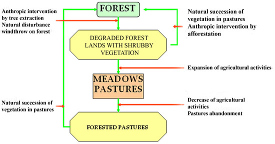 Figure 10. The dynamics between the forest and areas covered with shrubby vegetation specific to the Upper Bistrița Basin.
The overall results show that the pace of landscape changes was higher for the period 1990–2010 and lower for the next period (2010–2020) but significant. The classes “bareland/settlements” (Figure 7a) and “grassland” (Figure 6b) underwent the greatest changes, having an oscillating dynamic, one to the detriment of the other. The classes “forests” (Figure 6a) and “bush” (Figure 7b) underwent major changes in the period 2010–2021.
Regarding the estimation of future land use/cover dynamics, the authors of the study established two scenarios. Thus, based on the trends observed in the years 1990–2021, it is estimated that future changes will affect approximately 7% of the total area in the first scenario (the optimistic scenario) and 15.2% in the second (pessimistic) scenario. This could mean that, by 2050, there will be a possible increase in built-up areas by 5.3%, arable land by 0.6%, and open spaces (with little or no vegetation) by 48%. It can also be extrapolated that complex agricultural crops will vary by 1.2%, and permanent crops will decrease by 15.2%. Vegetation associations and/or herbaceous species could vary by 18.3%, forest areas by 0.2%, heterogeneous agriculture by 6.2% and natural pastures by 1.1%.
Landscape fragmentation was studied using three different methods:
(1) The calculation and analysis of landscape structure indicator values (total area of classes, total number of classes of forest types, average size of classes, average shape index, average fractal dimension, average nearest neighbour distance, average proximity index);
(2) The analysis of changes in the number of small units specific to forest areas achieved by grouping adjacent regions;
(3) The quantification of land use/cover changes for forest areas [21].
The results of the study show that the spatial–temporal dynamics of land use and cover had a major impact on the structure and functionality of the Carpathian landscape.
The evolution of the population reflects the influence of that population on changes in the environment and land use in the study area, which had a significant impact. We observed an important decrease in the population for the period 1990–2021, a phenomenon that was caused by migration to large urban centres following changes in the Romanian economy after 1990 (Table 4). In Table 4, we included the population statistics of the representative localities located in the study area.

Table 4.
The evolution of the population during the period 1990–2021; data source: [22].
The factors responsible for changes in land use/cover, both currently and for future changes, are represented by urbanization and industrialization, the intensification of agriculture, the abandonment of agricultural land, afforestation, and the deforestation of forested land. The future dynamics of land use/cover will vary according to regional differences depending on the biophysical and socio-economic potential of each administrative region in the territory of Romania.
Causes of Land Use Changes
As the main causes, all changes in the dynamics of land use in the study area share population and occupational dynamics that occurred in these 30 years. The fall of communism caused forced industrialization in rural and peri-urban areas to collapse, and this fact was reflected in changes in the population of the Upper Bistrița basin. At the beginning of the 1990s, intensive agriculture was used but was still ineffective. In the last 30 years, mountain agriculture that used unsustainable technologies became ineffective, ending up being practised only for subsistence in the households of local residents. Even if, in general, mountain populations are not very prone to migration, given the difficult socio-economic context of the 2000s, this fact comes (in this area) as a result of the socio-economic changes. This fact led to a large percentage of the locals migrating to larger urban centres or leaving Romania in search of a better life. Subsistence mountain agriculture has a tendency to revive but only on much smaller surfaces, which is correlated with a decrease in human/farm animal populations and efficiency through the mechanization of work.
The emergence of mass tourism is another factor that is extremely important in the dynamics of land use and landscape in the studied area. This led to the appearance of a new tourist infrastructure with the aggressive development of accommodation spaces and new service roads. Even so, the impact of these new developments on habitats is small, or they do not exceed the major environmental changes that took place before 1990 in importance.
5. Conclusions
This study, carried out on the upper basin of Bistrița for the period 1990–2020, highlighted a tendency to reduce land cover with forest vegetation and an increase in the transition zones between forest and shrub vegetation.
In recent years, a reverse change trend has been observed as a result of the afforestation processes of forest lands affected by logging processes.
Our study confirms significant changes in the upper basin of Bistrița in terms of land use during the studied period (1990–2021). Thus, we observed that the class “bareland/settlements” decreased, in just two decades, by 0.25%, which indicates a regression, but if we look individually, urbanization had an oscillating evolution. Also, in the period 2000–2021, the area covered by the “forest” class decreased by approximately 6.5%.
The “bush” class shows a much more oscillating evolution, basically because of the way we apply two different methods and the way the lands are classified in the classes. Thus, the current value is 16.4% of the total. For the “bush” category, the problems appear only in the first temporal interval (1990–2000) because of the inaccuracy of the data. In the case of the first method, the values fluctuated significantly, falling from 38,752 ha to only 1530 ha; however, starting in 2006, since the accuracy of the input data improved, the values balanced, with the class having values between 46,228 ha and 47,526 ha, showing the true extent of the spread of this type of land cover.
As a last observation, we can say that all these changes took place in a complex social and territorial context that, in recent years, has been increasingly affected by obvious climate changes, as well as the appearance of non-native plant species that have aggressive tendencies in relation to native habitats [14].
As a result, the changes are major, with a very large impact on the appearance of the landscape [22] (please see Supplementary).
Supplementary Materials
The following supporting information can be downloaded at: https://www.mdpi.com/article/10.3390/d15090980/s1, Figure S1. Dynamics between antropic and natural areas with shrubby vegetation and grassland in the upper Bistrita basin (a,b,c,d,e). Figure S2. Changes in the opposite direction of areas with shrub vegetation towards forest through natural or artificial regeneration in the upper Bistrita basin. Figure S3. Typical landscape for the mountain area of the upper Bistrita basin. Figure S4. Change in land cover from pasture/natural meadow to forest determined by the abandonment of agricultural activities in the mountain area. Figure S5. Dynamics between the coniferous forest and areas with shrubby vegetation following the action of climate risk factors in the upper Bistrița basin.
Author Contributions
Conceptualization, V.J., B.-M.N. and V.S.-L.; methodology, V.J., I.P. and V.S.-L.; software, V.J., I.P. and V.S.-L.; validation, V.J. and A.N.; formal analysis, V.J., M.B., I.P. and B.-M.N.; investigation, B.-M.N., V.J. and I.P.; resources, V.J. and N.C.; data curation, A.N. and V.S.-L.; writing—original draft preparation, V.J., V.S.-L. and B.-M.N.; writing—review and editing, V.S.-L., V.J. and B.-M.N.; visualization, M.B, N.C., B.-M.N. and V.J.; supervision, N.C. and B.-M.N.; project administration, B.-M.N.; funding acquisition, V.J. and B.-M.N. All authors have read and agreed to the published version of the manuscript.
Funding
This work was partly supported by the PROINVENT project in the framework of the Human Resources Development Operational Programme, 2014–2020, financed by the European Social Fund under the contract number 62487/03.06.2022 POCU 993/6/13/-Code SMIS: 153299.
Data Availability Statement
The images used are from Landsat 1 for 1990, Landsat 5 for 2000, and Landsat 7 for 2010 and 2021. The data were validated by the team in the studied area in the field.
Acknowledgments
This research was made possible with the support of the Non-Governmental Research Organization Biologic.
Conflicts of Interest
The authors declare no conflict of interest.
References
- Hamilton, C.M.; Martinuzzi, S.; Plantinga, A.J.; Radeloff, V.C.; Lewis, D.J.; Thogmartin, W.E.; Heglund, P.J.; Pidgeon, A.M. Current and Future Land Use around a Nationwide Protected Area Network. PLoS ONE 2013, 8, e55737. [Google Scholar] [CrossRef] [PubMed]
- Newbold, T.; Hudson, L.N.; Hill, S.L.L.; Contu, S.; Lysenko, I.; Senior, R.A.; Börger, L.; Bennett, D.J.; Choimes, A.; Collen, B.; et al. Global effects of land use on local terrestrial biodiversity. Nature 2015, 520, 45. [Google Scholar] [CrossRef] [PubMed]
- Visconti, P.; Bakkenes, M.; Baisero, D.; Brooks, T.; Butchart, S.H.M.; Joppa, L.; Alkemade, R.; Di Marco, M.; Santini, L.; Hoffmann, M.; et al. Projecting Global Biodiversity Indicators under Future Development Scenarios. Conserv. Lett. 2015, 9, 5–13. [Google Scholar] [CrossRef]
- Fischer, J.; Lindenmayer, D.B. Landscape modification and habitat fragmentation: A synthesis. Glob. Ecol. Biogeogr. 2007, 16, 265–280. [Google Scholar] [CrossRef]
- Huang, L.; Chen, K.; Zhou, M. Climate change and carbon sink: A bibliometric analysis. Environ. Sci. Pollut. Res. 2020, 27, 8740–8758. [Google Scholar] [CrossRef] [PubMed]
- Wang, Z.; Song, D.-X.; He, T.; Lu, J.; Wang, C.; Zhong, D. Developing Spatial and Temporal Continuous Fractional Vegetation Cover Based on Landsat and Sentinel-2 Data with a Deep Learning Approach. Remote. Sens. 2023, 15, 2948. [Google Scholar] [CrossRef]
- Pelorosso, R.; Leone, A.; Boccia, L. Land cover and land use change in the Italian central Apennines: A comparison of assessment methods. Appl. Geogr. 2009, 29, 35–48. [Google Scholar] [CrossRef]
- Sertel, E.; Topaloğlu, R.H.; Şallı, B.; Algan, I.Y.; Aksu, G.A. Comparison of Landscape Metrics for Three Different Level Land Cover/Land Use Maps. ISPRS Int. J. Geo-Inf. 2018, 7, 408. [Google Scholar] [CrossRef]
- Kucsicsa, G.; Popovici, E.-A.; Bălteanu, D.; Grigorescu, I.; Dumitraşcu, M.; Mitrică, B. Future land use/cover changes in Romania: Regional simulations based on CLUE-S model and CORINE land cover database. Landsc. Ecol. Eng. 2019, 15, 75–90. [Google Scholar] [CrossRef]
- Popovici, E.A.; Bălteanu, D.; Kucsicsa, G. Assessment of changes in land-use and land-cover pattern in Romania using Corine Land Cover Database. Carpathian J. Earth Environ. Sci. 2013, 8, 195–208. [Google Scholar]
- Draskovic, B.; Ponosov, A.; Zhernakova, N.; Gutalj, M.; Miletic, B. Land cover types and changes in land use in Republic of Srpska (Bosnia and Herzegovina) over the period 2000-2018. J. Geogr. Inst. Jovan Cvijic, SASA 2020, 70, 81–88. [Google Scholar] [CrossRef]
- Ursu, A.; Stoleriu, C.C.; Ion, C.; Jitariu, V.; Enea, A. Romanian Natura 2000 Network: Evaluation of the Threats and Pressures through the Corine Land Cover Dataset. Remote. Sens. 2020, 12, 2075. [Google Scholar] [CrossRef]
- Martínez-Fernández, J.; Ruiz-Benito, P.; Bonet, A.; Gómez, C. Methodological variations in the production of CORINE land cover and consequences for long-term land cover change studies. The case of Spain. Int. J. Remote. Sens. 2019, 1–19. [Google Scholar] [CrossRef]
- Negrea, B.-M.; Stoilov-Linu, V.; Pop, C.-E.; Deák, G.; Crăciun, N.; Făgăraș, M.M. Expansion of the Invasive Plant Species Reynoutria japonica Houtt in the Upper Bistrița Mountain River Basin with a Calculus on the Productive Potential of a Mountain Meadow. Sustainability 2022, 14, 5737. [Google Scholar] [CrossRef]
- Copernicus Global Land Service. 2021. Available online: https://land.copernicus.eu/global/index.html (accessed on 3 May 2022).
- Dolean, B.-E.; Bilașco, S.; Petrea, D.; Moldovan, C.; Vescan, I.; Roșca, S.; Fodorean, I. Evaluation of the Built-Up Area Dynamics in the First Ring of Cluj-Napoca Metropolitan Area, Romania by Semi-Automatic GIS Analysis of Landsat Satellite Images. Appl. Sci. 2020, 10, 7722. [Google Scholar] [CrossRef]
- Vorovencii, I. Quantifying landscape pattern and assessing the land cover changes in Piatra Craiului National Park and Bucegi Natural Park, Romania, using satellite imagery and landscape metrics. Environ. Monit. Assess. 2015, 187, 692. [Google Scholar] [CrossRef] [PubMed]
- Legea Nr 12000 Pentru Reconstituirea Drept. Propr. Asupra Teren. Agric. Şi Celor For. Solicitate Potrivit Prevederilor Legii Fondului Funciar Nr 181991 Şi Ale Legii Nr 1691997. 2000. Available online: https://www.cdep.ro/pls/legis/legis_pck.htp_act_text?idt=21873 (accessed on 13 May 2023).
- Stoilov-Linu, V.; Danila, A.-M.; Negrea, B.-M. Current land use and the trend of usage during the last 30 years in the Dornei Basin, Romania. Montol. J. Ce-Mont Rom. 2022, 14, 9. [Google Scholar]
- Falťan, V.; Bánovský, M.; Blažek, M. Evaluation of land cover changes after extraordinary windstorm by using the land cover metrics: A case study on the high Tatras foothill. Geografie 2011, 116, 156–171. [Google Scholar] [CrossRef][Green Version]
- Niculae, M.-I.; Pătroescu, M. Quantifying forest ecosystems fragmentation in the Subcarpathians between the Râmnicu Sărat and the Buzău valleys, Romania, using landscape metrics. In Forum Geografic X; University of Craiova: Craiova, Romania, 2011; pp. 187–194. [Google Scholar]
- Kuemmerle, T.; Müller, D.; Griffiths, P.; Rusu, M. Land use change in Southern Romania after the collapse of socialism. Reg. Environ. Change 2009, 9, 1–12. [Google Scholar] [CrossRef]
Disclaimer/Publisher’s Note: The statements, opinions and data contained in all publications are solely those of the individual author(s) and contributor(s) and not of MDPI and/or the editor(s). MDPI and/or the editor(s) disclaim responsibility for any injury to people or property resulting from any ideas, methods, instructions or products referred to in the content. |
© 2023 by the authors. Licensee MDPI, Basel, Switzerland. This article is an open access article distributed under the terms and conditions of the Creative Commons Attribution (CC BY) license (https://creativecommons.org/licenses/by/4.0/).