Article

Fish Diversity and Ichthyofauna of Areas Adjacent to the Demilitarized Zone in South Korea

1
Advanced Aquaculture Research, National Institute of Fisheries Science, Changwon 51688, Republic of Korea
2
National Institute of Ecology, Seocheon 33657, Republic of Korea
3
Nakdong River Environment Research Center, National Institute of Environmental Research, Goryeong 40138, Republic of Korea
4
Kosoo Biology Institute, Seoul 07955, Republic of Korea
*
Author to whom correspondence should be addressed.
Diversity 2022, 14(12), 1011; https://doi.org/10.3390/d14121011
Submission received: 5 September 2022 / Revised: 18 November 2022 / Accepted: 18 November 2022 / Published: 22 November 2022

Abstract

:
The Korean Demilitarized Zone (DMZ) was established in 1953 during the cessation of the Korean War, which divided the Korean Peninsula into North and South Korea. The DMZ is a representative biodiversity resource because it limits human activities. The current status of faunal diversity in adjacent areas of the DMZ was investigated in five regions at 91 sites from 2015 to 2019. A total of 19,562 individuals were collected and identified, including 81 species, 19 families, and 11 orders. Zacco koreanus was the most abundant fish species (relative abundance of 21.9%), while other key species were Zacco platypus (18.2%), Rhynchocypris oxycephalus (5.2%), Rhynchocypris steindachneri (4.9%), and Pungtungia herzi (3.7%). Notably, twenty-nige endemic and seven Red Data Book species were recorded, and three exotic species, Carassius cuvieri, Micropterus salmoides, and Lepomis macrochirus were found at five sites. Human activities and disturbances were found at 34.0% of all sampling sites, and the highest disturbance factors were river dredging and agricultural use (seven sites), sewage (five sites), and fisheries and development (two sites). We recommend that the governments of South and North Korea collaboratively manage the DMZ to protect ecological diversity and maintain its status as a symbol of peace.

1. Introduction

The Korean Demilitarized Zone (DMZ) was established on 27 July 1953 as a result of signing the Armistice Agreement at the end of the Korean War [1]. The DMZ is situated 2 km from the Northern Limit Line (NLL), the Southern Limit Line (SLL), and the Military Demarcation Line (MDL) and covers an area of approximately 99,144 ha. The MDL (248 km) divides the Korean Peninsula in half, from the western end (Paju, Gyeonggi-do Province) to the eastern end (Goseong, Gangwon-do Province). The NLL and SLL have a cease-fire line, and the armies of the North and South are stationed on this line. There is a civilian control zone (CCZ) surrounding the MDL to protect military operations and facilities in the vicinity of the MDL and maintain security, and this area restricts the entry and exit of civilians. The civilian control line designates an additional buffer zone to the DMZ within a distance of 5 to 10 km from the SLL of the DMZ, with an area of approximately 231,405 ha [2].
The DMZ divides the Korean Peninsula into two areas and has had unique ecosystems under strict control over the last 70 years. The DMZ is a representative biodiversity record for the Korean Peninsula, revealing not only the world’s rarest and endangered species but also some that have not yet been discovered [2]. In 1974, the Ministry of Culture and Public conducted the first academic survey of the DMZ and CCZ [3]. Subsequently, since the beginning of the 1990s, various reports on the environment and ecology of these zones began to be published at the national level, providing an inventory of the ecological status of the area, including vegetation, aquatic and forest insects, freshwater fish, and the overall landscape [4,5,6,7,8,9,10,11,12,13,14,15,16,17]. Most of these inventories were only conducted in some parts of the zones because access to the whole area was limited by the possibility of encountering mines and/or military security. Therefore, spatial limitations hampered the completion of surveys.
The geographical distribution of animals is determined by their preferred habitat, which includes factors such as topography, climate, and vegetation characteristics. However, freshwater fish species have unique geographical limitations determined by the river system in which they are present [18]. Based on the patterns of endemism of freshwater fish and the geographic barrier presented by the Baekdudaegan mountain ranges in Korea, Kim [19] divided the Korean Peninsula into three biogeographic regions: West, South, and Northeast Korean subdistricts, which differ in faunal and floral diversity. Vicariant barriers separating the three subdistricts include the Noryeongsanmaek and Sobaeksanmaek (in Korean, ‘sanmaek’ means ‘mountains’) ranges between the West and South Korea subdistricts, and the Taebaeksanmaek, Nangnimsanmaek, Hamgyrongsanmaek, and Macheollyeongsanmaek between the West and Northeast Korea subdistricts. These geographic barriers have been hypothesized to play a key role in the allopatric speciation of freshwater fish in Korea [20]. If the Baekdudaegan are an ecological axis in the north-south direction of the Korean Peninsula, the DMZ is an ecological axis in an east-west direction and plays an important role as a source of biodiversity in Korea [21].
Therefore, an accurate account of species diversity and fauna in these different subregions is of central importance for data-based conservation and sustainable development efforts in this region. Consequently, the objectives of this study are to (1) investigate the current status of fish diversity and ichthyofauna in areas adjacent to the DMZ in Korea for the period 2015 to 2019, (2) provide fundamental research data and recommendations on the future conservation and utilization of natural resources in the DMZ area, and (3) review the existing literature to provide comprehensive information on fish diversity and fauna in the DMZ, and how this has changed over time.

2. Materials and Methods

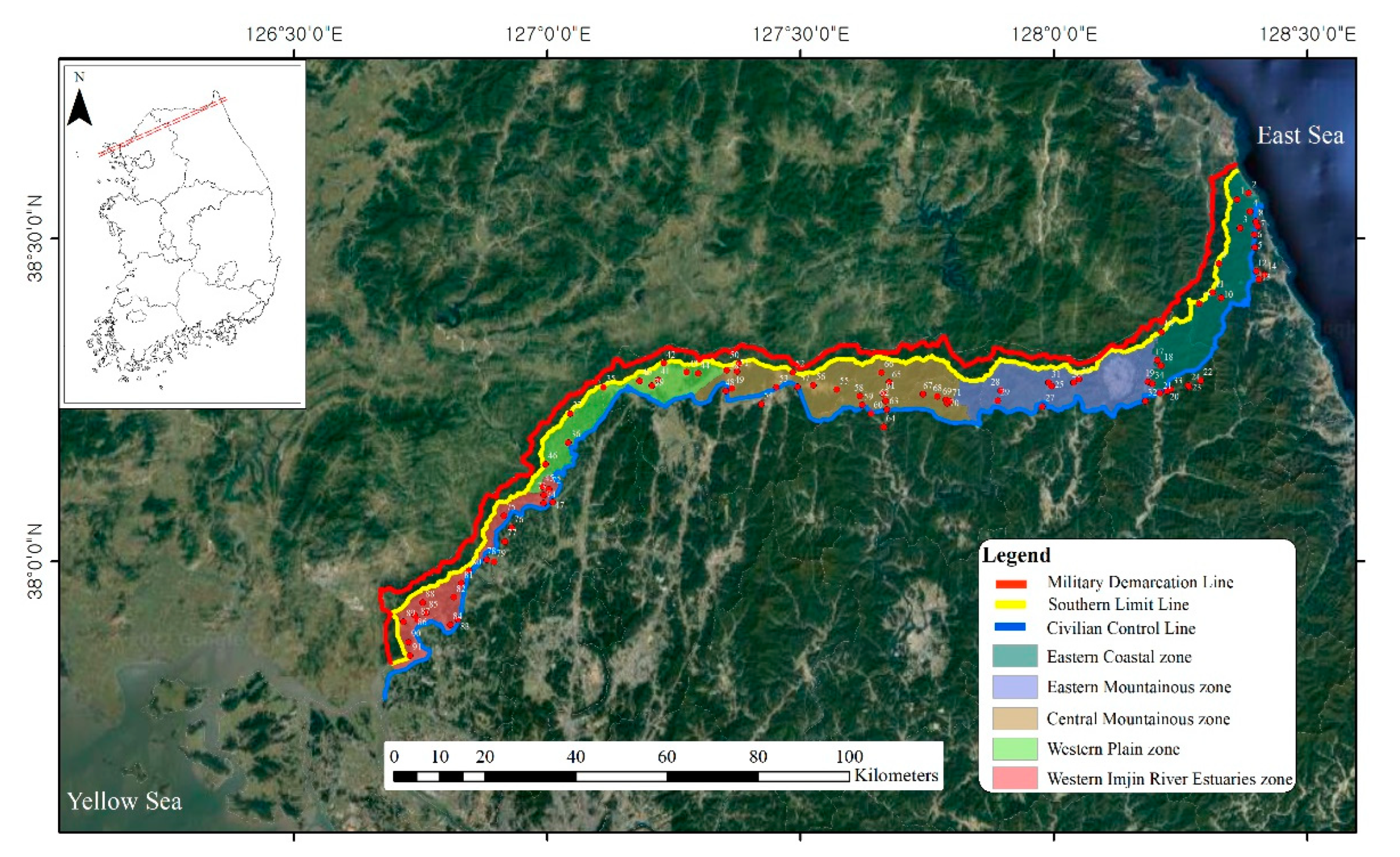
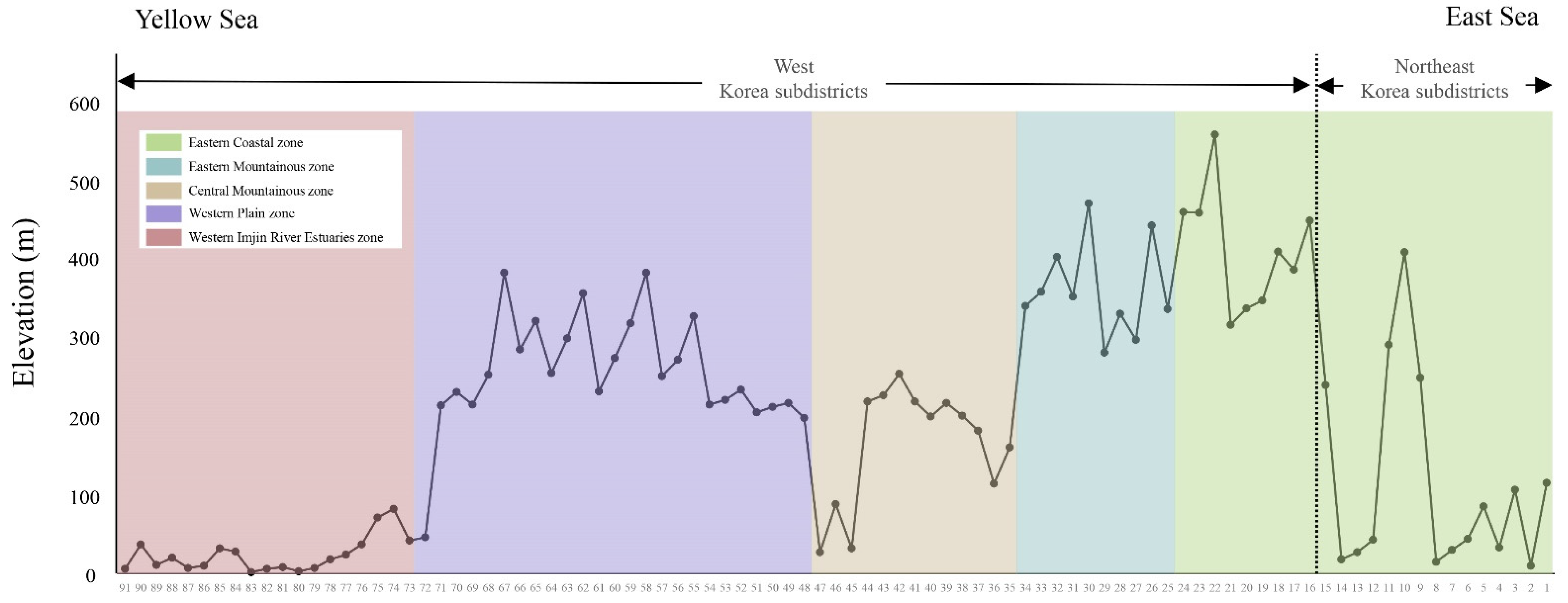
2.1. Study Regions and Sites

Based on previous research data and available literature [2], this study investigated the current status of fish species inhabiting areas adjacent to the DMZ. Based on the climate characteristics and ecological features of the mountains, rivers, CCZ and DMZ, and their adjacent areas, the study area was divided into five regions with a total of 91 sampling sites: the eastern coastal zone (sites 1–24) in 2015, eastern mountainous zone (sites 25–34) in 2016, western plain zone (sites 35–47) in 2017, central mountainous zone (sites 48–71) in 2018, and western Imjin River estuary zone (sites 72–91) in 2019, and included all river systems (Bukhangang, Hantangang, Imjingang; in Korean, ‘gang’ means ‘river’) (Figure 1). The investigations between 2017 and 2018 had to be adjusted according to the circumstances of the military units. Additionally, some of the investigations only surveyed one time due to military situations.
Additionally, streams in the eastern coastal zone were divided into Northeast Korean subdistricts (sites 1–15) flowing into the East Sea, and West Korean subdistricts (sites 16–91), which flow into the Bukhangang and West Sea centered on Taebaeksanmaek. The elevation at each survey site was recorded using an altimeter (SKT-102, Tlead, Seoul, Korea) for analyzing the relationship between species and elevation.

2.2. Ichthyofauna Sampling and Geographic and Physical Surveys

The ichthyofauna sampling in each survey region was conducted one to three times (spring, summer, and autumn) each year from 2015 to 2019 in cooperation with the army: 24 sites in the eastern coastal zone from July to September 2015 (one to two times), 10 sites in the eastern mountainous zone from June to August 2016 (three times), 13 sites in the western plain zone from May to September 2017 (two times), 24 sites in the central mountainous zone from May to October 2018 (two to three times), and 20 sites in the western Imjin River estuary zone between May and September 2019 (two to three times) (Figure 1; Table S1).
The geographic and physical data surveys of river width (the distance between the riverbanks), water width (the width of the flowing water), and water depth were measured using a distance-measuring telescope (Yardage Pro Tour XL, BUSHNELL, Tokyo, Japan) and a tape measure. In addition, river type (see Table S1 for definitions) and bottom structures were assessed according to the methods proposed by Kani [22] and Cummins [23], respectively.
Fish were collected using both a cast net (6-mm mesh; 12.5 m2 = 2 m × 2 m × 3.14) and a scoop-net (4-mm mesh; 1.35 m2 = 1.5 m × 0.9 m) depending on the water width and depth for the investigation of various habitats and ichthyofauna. When the water width was <10 m, the cast nets were cast five to 10 times and scoop-nets were used for 30 min at water widths between 10 and 30 m; 11 to 20 casts were made and scoop-nets were used for 30 to 60 min, and when the water width was >30 m, more than 20 casts were made, and scoop-nets were used for over 60 min. These methods were in accordance with the Guidelines of the National Natural Environment Survey (IV) [24].
All survey habitat types, including riffles, runs, and pools, were investigated in an upstream direction for a distance of 50 to 100 m. The reservoir and pond sites (39, 42, 44, 72, 85, and 90), representative locations were selected as the place where the fish were in various habitats and investigated to ensure that they were as reflective as possible. The cast net survey was conducted on the inlet areas that enter the reservoir and pond, and the kick net survey was performed only at the shallow edge on them. Although we could not always survey two sites (35 and 37) because they were in hazardous areas with mines, we conducted at least one survey with the permission of the military units.
The individual fish captured were identified and counted in situ with the naked eye and then immediately released; however, some ambiguous specimens were preserved in 10% formalin and later identified in the laboratory. All specimens were identified according to the process described by Kim and Park [25] and Kim et al. [26] using the classification system proposed by Nelson [27]. Scientific names and authorities followed those of the National Species List of Korea [28]. Although several of the species and family names have been revised (FishBase, 2022), we used the older system to maintain consistency and comparability with previous studies.

2.3. Data Analysis

Diversity [29], richness [30], evenness [31], and dominance [32] were calculated for each of the five regions. The hierarchical cluster analysis of species composition of the five regions was analyzed using the Bray–Curtis similarity index, performed with the PRIMER software (Primer-e 6, New Zealand Ins., Palmerston North, New Zealand). Statistical analyses were conducted using the SYSTAT software (Systat version 24.0, SPSS Inc., Chicago, IL, USA). To evaluate the relationship between geographical and physical factors and community composition of fish, principal component analysis (PCA) was performed using in the PRIMER software.
Pearson’s correlation, linear regression, and quadratic analysis were used to test the relationships among the elevation, the total number of species, and the total number of endemic species at each survey site. Since the survey method varied depending on the elevation and river type, we limited the comparative survey sites to those where more than 100 individuals were collected. Statistical significance was considered when p was <0.05.

2.4. Human Activities and Disturbance

Human activities and disturbances were surveyed throughout the areas adjacent to the DMZ during the faunal sampling. We recorded human activities and use, both inside and outside the investigation sites, which had direct or indirect impacts on water quality, fish populations, and environment and classified them into four categories: (1) river dredging, (2) agricultural use, (3) sewage, and (4) fisheries and development.

3. Results

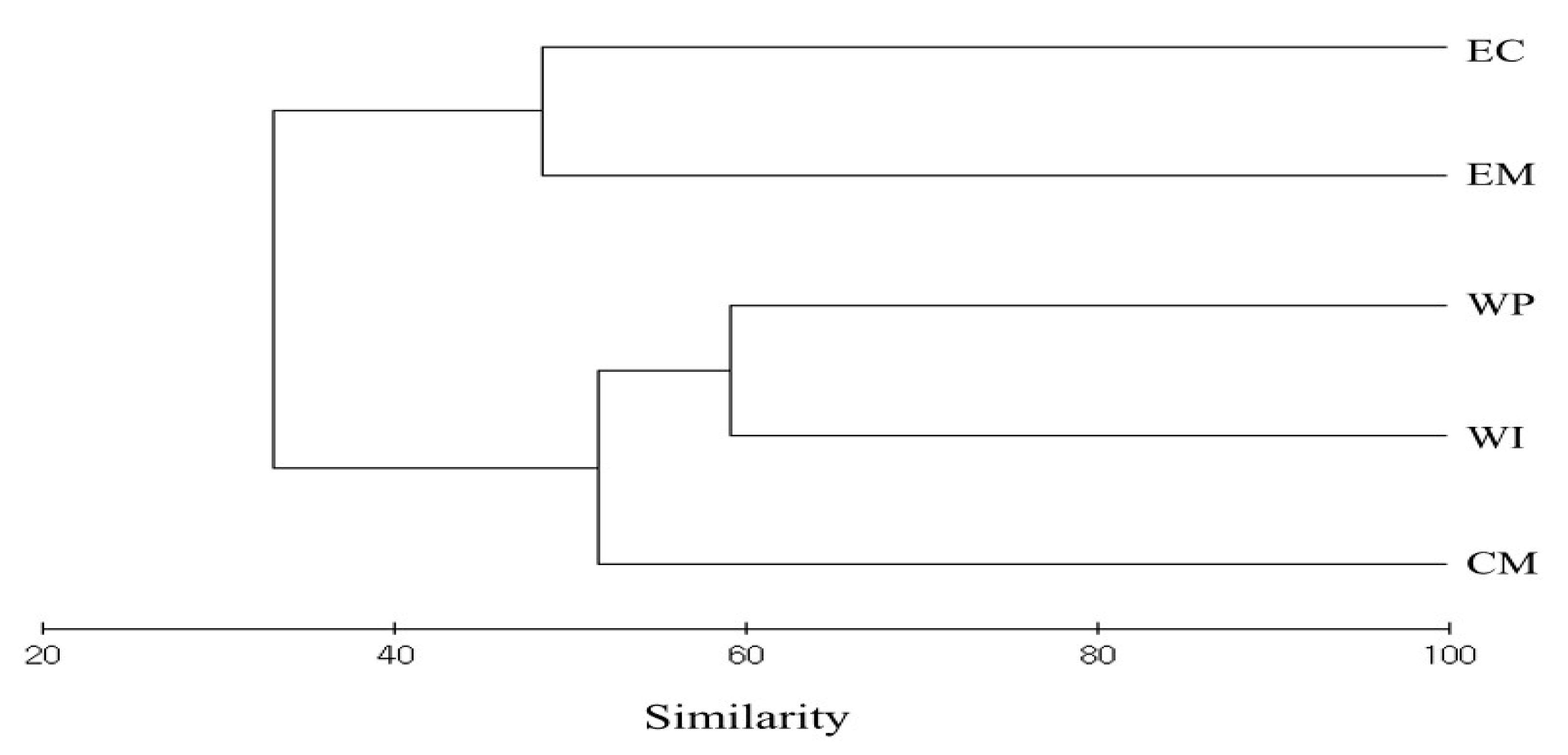
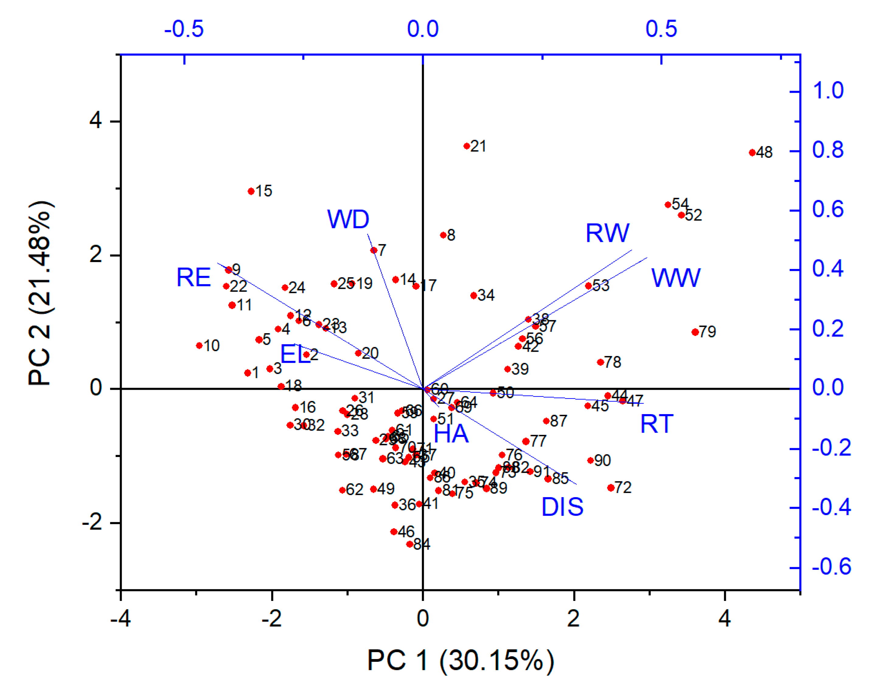
3.1. Geographic and Physical Analysis

The river and water width, water depth, river type, and bottom structures in each of the survey sites are shown in Table S1. The study sites were mostly small-to-mid-sized streams with a water width of less than 50 m (range, 0.5–50 m) and water depth of 1.5 m (0.1–1.5 m, n = 84), except for six reservoir and pond sites (39, 42, 44, 72, 85, and 90), which had depths of 0.3–10 m. There were five large streams with a water width of more than 100 m, including two sites (80 and 83) in the western Imjin River estuary zone and three sites (48, 53, and 54) in the central mountainous zone. Although most sites (16 to 91) included streams that flowed into the Bukhangang, Hantangang, and Imjingang and were distributed in the West Korean subdistricts, a few sites (1 to 15) had independent streams flowing into the East Sea and these were distributed in the Northeast Korea subdistricts.
The site at the highest elevation was centered on Taebaeksanmaek; elevation decreased gradually in a westerly direction, whereas it dropped sharply in an easterly direction (Figure 2). Of the five regions, the eastern mountainous zone had the highest mean ± SD elevation of 359.8 ± 60.3 m (range 280–469 m), followed by the central mountainous zone at 264.3 ± 56.5 m (197–381 m), the eastern coastal zone at 225.7 ± 181.5 m (10–556 m), the western plain zone at 164.0 ± 75.0 m (27–253 m), and the lowest mean elevation was in the western Imjin River estuary zone, 24.8 ± 22.4 m (2–82 m). The river types in the mountainous zone were Aa and Aa-Bb types, and they took the forms of Bb, Bb-Bc, and Bc types toward the Yellow Sea. At several sites (86–89 and 91) in the western Imjin River estuary zone, more than 99% of the bottom structure was composed of sand and mud (with particle sizes < 2 mm in diameter) owing to the influx of mud from estuaries.

3.2. Fish Diversity and Fauna

In total, 19,562 individual organisms were collected between 2015 and 2019. Examination of these specimens revealed 81 species belonging to 19 families and 11 orders, and their distributions in the five regions are shown in Table 1 and Table S2. The family Cyprinidae was the most dominant with 43 species identified, representing approximately 46.3% of all identified species. Zacco koreanus (relative abundance (RA), 21.9%) was the most abundant fish species overall, while other key species were Zacco platypus (18.2%), Rhynchocypris oxycephalus (5.2%), Rhynchocypris steindachneri (4.9%), and Pungtungia herzi (3.7%).
In the eastern coastal zone, 2544 individuals belonging to 38 species and 13 families were collected, and the dominant species was Zacco koreanus (appearance, 13 of 24 sites; RA, 43.6%). In the eastern mountainous zone, 19 species and eight families (from 1516 individuals) were sampled, and Zacco koreanus (8 of 10 sites; 38.7%) was the dominant species. In the central mountainous zone, 43 species and 12 families were classified from 7744 individuals investigated, and Zacco koreanus (20 of 24 sites; 30.3%) was again the most dominant species. In the western plain zone, 46 species and 10 families were found among 3405 individuals collected, and Zacco koreanus (10 of 13 sites; 21.4%) was the dominant species. Of the 4353 individuals collected in the western Imjin River estuary zone, 58 species and 14 families were classified, and Zacco platypus (12 of 20 sites; 28.6%) was the dominant species.
Community indices of each survey site in the five regions are shown in Table 2. The diversity and richness index was higher in the western Imjin River estuary zone than in the other regions. The evenness index was highest in the western plain zone and the dominance index was highest in the eastern mountainous zone.
Hierarchical clustering showed that the five regions tended to cluster into two groups according to species composition (Figure 3). The first group included the WP, WI, and CM zones and the second group included the EC and EM zones.
The PCA was used to identify possible relationships between eight factors (river width, water width, water depth, river type, elevation, human activity, survey regions, and districts) and a number of species at the 89 sites except for two sites (80 and 83) due to appear to be extremely wide of river and water widths (Figure 4). Eigenvalues (lambda) were 0.301, 0.214, 0.165, and 0.134 for the first to fourth axes, respectively. The number of species was significantly correlated with elevation, average river and water widths, and water depth and poorly correlated with human activity and disturbance, survey regions, districts, and river type.
In the West Korea subdistrict, 73 species and 17 families (17,603 individuals) were found, of which 55 species and 15 families were only found in these subdistricts, e.g., Lethenteron reissneri, Cyprinus carpio, Carassius cuvieri, Rhodeus ocellatus, and Rhodeus uyekii. Whereas in the Northeast Korea subdistricts, 21 species and 11 families (1959 individuals) were identified, of which eight species and seven families were unique to this subdistrict: Squalidus multimaculatus, Rhodeus semotilus, Orthrias toni, Iksookimia pacifica, Plecoglossus altivelis, Oncorhynchus masou, Pungitius kaibarae, and Cottus hangiongensis.
Analysis of the total number and the number of endemic species to Korea at each survey site demonstrated that the highest numbers and diversity were found at elevations of 0–100 m and 201–300 m. The survey sites at elevation of 0–100 m were 32 sites, 6697 individuals belonging to 70 species were collected, and the dominant species was Zacco koreanus (23.0%). The sites at elevations of 101–200 m were eight sites, 41 species, and 1916 individuals were sampled, and Zacco koreanus (26.9%) was the dominant species. The investigation sites at elevations of 201–300 m were 27 sites, 51 species were classified from 8604 individuals investigated, and Zacco koreanus (27.9%) was the most dominant species. The sampling sites at elevations of 301–400 m were 15 sites, 25 species were found among 1910 individuals collected, and Zacco koreanus (40.9%) was the dominant species. Of the 435 individuals collected at the survey sites at elevations of over 401 m, 16 species and nine sites were confirmed, and Rhynchocypris kumgangensis (36.3%) was the dominant species.
There was a negative correlation between elevation and the total number of species; however, there was a positive correlation between elevation and the total number of endemic species (linear regression analysis, total species, R2 = 0.04, p = 0.110; endemic species, R2 = 0.05, p = 0.077). High species richness was confirmed at an elevation of approximately 200 m for all species and for endemic species (Figure 5).

3.3. Endemism

Of the 81 species identified in all regions, eight were endangered in Korea (three families; RA, 9.8%: Lethenteron reissneri, Acheilognathus signifer, Pseudopungtungia tenuicorpa, Gobiobotia macrocephala, Gobiobotia brevibarba, Rhodeus semotilus, Brachymystax lenok tsinlingensis, and Cottus hangiongensis). One species, Hemibarbus mylodon, is a natural monument (1 family; 1.2%), and 29 species were endemic to Korea (eight families; 35.8%). The number of endemic species in the five regions was highest in the western plain zone (20 species) and the central mountainous zone (20 species) and lowest in the eastern mountainous zone (11 species). The dominant and other dominant endemic species in Korea were Zacco koreanus (57 of 91 sites; 62.6%), Coreoleuciscus splendidus (26 of 91 sites; 28.5%), and Iksookimia koreensis (25 of 91 sites; 27.4%) across all survey sites.
Seven species listed as Endangered or Vulnerable in the Red Data Book of Korea [28] were recorded (EN, three families; 14.3%: Saurogobio dabryi and Rhynchocypris semotilus; VU, Ladislavia taczanowskii, Hemibarbus mylodon, Gobiobotia brevibarba, Brachymystax lenok tsinlingensis, and Cottus hangiongensis). Three exotic species, Carassius cuvieri (13 individuals, sites 44 and 91), Micropterus salmoides (39 individuals, sites 43, 44, and 48), and Lepomis macrochirus (15 individuals, sites 44 and 77) were collected; the majority were in the western plain zone (49 of 67 individuals; 73.1%), and none were found in the eastern mountainous and eastern coastal zones.

3.4. Human Activities and Disturbance

Human activities and disturbances were consistently observed throughout the survey sites and evidence of these was found at 31 of 91 sites (RA, 34.0%). The highest disturbance factors were identified at 17 sites; river dredging and agricultural use, sewage, and fisheries and development were recorded at seven, five, and two sites, respectively. In particular, river dredging and agricultural use directly sieve or disrupt river sediments, causing large amounts of mud, sand, and gravel to become suspended, thereby reducing water quality and destroying faunal habitats. In the present study, the number of species was poorly affected by human activity and disturbance, presumably, because some survey sites will reflect the habitat features facing the prevailing currents owing to discontinued monitoring (Figure 4).

4. Discussion

4.1. Geographic Characteristics and Ichthyofauna

The ichthyofauna survey in the DMZ areas was conducted by various government agencies such as the Ministry of Environment, the Korea Forest Service, and the Korea Cultural Heritage Administration until the late 2000s. Subsequently, the National Institute of Ecology has conducted this survey as a commissioned task of the Ministry of Environment since 2014 [2]. The sampling regions, based on the available literature, were broadly divided into the Eastern, Central, and Western regions and the geographic and physical characteristics of the study sites were similar to those in the present study: water width of fewer than 30 m and water depth of 1.5 m (Table S1). The eastern mountainous zone, centered on Taebaeksanmaek and consisting of a high mountain range, exhibited the narrowest water width and the highest elevation. The water width increased and elevation decreased as sites were sampled in the central mountainous zone, western plain zone, and western Imjin River estuary zone [2,33].
In the present study, the highest number of species was found in the western Imjin River estuary zone (58 species) because of the inclusion of brackish water and a combination of primary and secondary freshwater fish. The western plain zone had the second highest species diversity (46 species), followed by the central mountainous zone (43 species), which included the midstream and upstream regions of Imjingang and had relatively diverse habitats. The West and Northeast Korea subdistricts were included in the eastern coastal zone (38 species) to reflect the variety of fish species occurring in this zone due to an independent stream flowing into the East Sea. The lowest number of species was recorded in the eastern mountainous zone (19 species) and this was attributed to the absence of large rivers and relatively simple habitats [33,34].
Based on 21 previously published reports, a comprehensive list of ichthyofauna identified in the adjacent areas of the DMZ included 136 species belonging to 33 families and 14 orders (a total of 91,964 individuals) (Table S2). Zacco platypus (RA, 14.9%) was the most abundant species, while other dominant species were Zacco koreanus (14.4%), Rhynchocypris steindachneri (9.5%), Hypomesus nipponensis (3.9%), Rhynchocypris oxycephalus (3.5%), and Rhinogobius brunneus (2.9%). In these reports, the scientific names were updated using the most recent taxonomic reviews and publications and eliminated the fish listed such as ambiguous, misidentified, or diadromous species and reported approximately 109 species (Table S2). Only one species, Squaliobarbus curriculus, was newly added.
The most recent ichthyofauna investigation of the DMZ areas was conducted by Mintongseon monitoring from 2012 to 2014 [13,14,15,16]. In this monitoring, 33,384 individuals belonging to 85 species and 18 families were collected, and four more species (13,822 individuals) were identified than in the present study. However, 13 species that were confirmed in the Mintongseon monitoring were not found in this study, and nine species were newly added by the present study (Table S2). Although the length of the study periods did not differ much, there were 22 different species between the two surveys. In addition, for these study results to be reliable enough to base future conservation and human-use management decisions on, it is estimated that three surveys must be conducted continuously at the same site throughout the spring, summer, and autumn [35,36].
Because ichthyofauna has limited distribution patterns due to the interaction of various ecological and historical conditions related to geographical events, the study of species distribution patterns has become an important topic for the study of biogeography [19]. The Taebaeksanmaek is a barrier that has separated the water systems in the east and west districts since the beginning of the Third Era (Pliocene, the epoch in the geologic time scale that extends from 5.333 million to 2.58 million years ago), so that differences in freshwater fish fauna can be found in each region [34]. The geographic barrier of the Baekdudaegan mountain ranges in the Korean Peninsula is divided into West, South, and Northeast Korean subdistricts and has different fish fauna. However, the appearance of many new species not previously recorded in these water systems in recent years has progressed due to artificial phenomena, such as releasing fish, rather than natural processes. Among the species that did not appear before the 1960s–70s in the Northeast Korea subdistricts, 11 species, Pungtungia herzi, Pseudorasbora parva, Squalidus multimaculatus, Misgurnus mizolepis, Silurus asotus, Odontobutis interrupta, Zacco koreanus, Zacco platypus, Silurus microdorsalis, Liobagrus andersoni, and Coreoperca herzi, were identified in this study and were presumed to have appeared since the 1980s–90s [37]. The artificial introduction of native species into a water system in which they did not previously occur can also pose a risk because these species are effectively exotic species; therefore, fish management and efforts to elucidate the source of introduction of domestic exotics are required at the government level [21,35,38].

4.2. Endemism

This survey showed that the areas adjacent to the DMZ play an important role in freshwater fish diversity in South Korea, especially for endemic species. In the Mintongseon monitoring a higher number of Korean endemic species were recorded (RA, 40.7%, [13,14,15,16]) than in the present study (35.8%), the report of the DMZ areas (30.3%, [33]), and the Korean national parks survey (33.3%). Additionally, the Mintongseon monitoring revealed a higher level of endemism than the proportion of endemic species in the entire Korean Peninsula (23.6%, [39]). These results demonstrate the conservation value of the DMZ areas because the level of endemism identified in several survey sites was higher than the overall Korean endemic frequency of 30%.
There were 11 and 16 endangered species (I rank: an endangered species and II rank: a species that may become extinct in the near future if current threats are not removed, respectively) in Korea, and four, 13, and seven threatened species (Critically endangered, Endangered, Vulnerable, respectively) in the Red Data Book of Korea, designated by the Ministry of Environment [40]. When comparing the present study with Mintongseon monitoring, two endangered species (Lethenteron japonica and Pungitius sinensis) were not found in the present study; this may be because they have restricted distributions that were not sampled in the eastern coastal zone [13,14,15,16]. Although five endangered species (Lethenteron japonica, Acheilognathus signifer, Gobiobotia marcocephala, Gobiobotia brevibarba, and Gobiobotia naktongensis) were previously identified in the adjacent areas of sites 78 and 79 in the western Imjin River estuary zone, only two of these (Gobiobotia marcocephala and Gobiobotia brevibarba) were identified in the current study. It is presumed that severe habitat disturbance due to river dredging for restoration of flood damage in 2018 resulted in the loss of the other three endangered species. Considering that a variety of endangered and endemic species were found in the main regions, the DMZ areas in Korea reflect biogeographical patterns and the diversity of distinct fish communities, which can be valuable from a conservation and preservation perspective.
The proportion of endemic species was highest at elevations of approximately 200 m, and the richness was similar to previous surveys of the DMZ areas and the Korean national parks survey [33,39]. Additionally, the frequency of endemic species associated with the total number of species was highest in mountain valleys and headwater streams. Three exotic species (Carassius cuvieri, Micropterus salmoides, and Lepomis macrochirus) were identified at five sites, where four sites were reservoirs or streams just below the reservoir, and one site was the estuary of Imjingang. Site 44 of the Togyo reservoir was one area where Micropterus salmoides and Lepomis macrochirus were introduced in the 1970s for aquaculture as a protein supply [41,42]. However, it is presumed that these exotic species escaped from the aquafarm to other nearby rivers and will have negative effects on the native fish communities in Korea [43,44,45]. This is an important finding and highlights the need for management to ensure that exotic species do not enter the eastern mountainous or eastern coastal zones, which currently do not have active native fish conservation practices in place.

4.3. Current Status and Conservation

The DMZ areas include ecosystems that are not easily accessible to people owing to military installations and access control measures; therefore, many people assume that these areas are well-conserved in their natural, undisturbed conditions [21]. However, in the present study, proximal forests and habitats were only found in the eastern mountainous zone and in the upper streams of Namgang in the eastern coastal zone. We found that most of the regions were affected by development and illegal cultivation, whereby wetlands had been converted into rice fields in the western plain zone and the western Imjin River estuary zone, and military installations in the form of military camps, were discharging raw sewage into the streams in the central mountainous zone. Sung et al. [38] classified land damage in the DMZ areas into six categories: alteration of initial landform, loss of surface layer, land pollution, alteration of soil chemical properties, a decline of vegetation, and invasion of foreign species. Battisti et al. [46] reported the disturbance ecology of anthropogenic threats and divided natural disturbance into seven events: Flooding and other events connected to river dynamics, fires, extreme meteorological events, water fluctuation, geological events, biotic agents (pathogens), and biotic agents (animal disturbance). These diverse disturbances could potentially cause alterations to water quality, hydrologic regimes, and fish habitats.
Frequent wildfires have also affected the DMZ stream ecosystems in terms of visibility acquisition resulting from intentional military activities after political corporation [47]. In addition, wildfires sometimes occur naturally and are difficult to extinguish owing to the restricted access to the DMZ areas; therefore, many areas are burnt. Some researchers argue that the DMZ areas have no conservation value because they are disturbed ecosystems due to human interference from wildfires, noise, and so on [48,49]. Fires can influence water quality, water chemistry, discharge regime, stream stability, coarse woody debris, and native freshwater fish and lead to the introduction of exotic plants [50,51]. However, the DMZ areas are a good habitat for herbivorous wildlife because of the lack of large predators and the increasing prey for wild animals. Although vegetation is in the early or mid-term stages of secondary succession because of frequent wildfires, it can provide a wider variety of food for mammals and birds. In addition, wetlands are not used as agricultural land but are preserved, providing valuable habitats for many fish, amphibians, and reptiles [21]. Though there was secondary succession due to wildfires, the DMZ maintains a high degree of biodiversity that would allow it to return to its natural forest condition if wildfires were banned.
Many researchers have reported that the Baekdudaegan mountain range is an ecological axis in the north-south direction of the Korean Peninsula, and the DMZ is the east-west axis. This is because the DMZ has been less artificially affected for a long period of time and provides an important biodiversity corridor between East and West on the Korean Peninsula [33,52,53]. Therefore, the DMZ is considered to represent areas of national and international importance that are worth protecting owing to their ecological diversity and value [17]. However, negotiations on the conservation of the DMZ are slow and difficult because South and North Korea are still in a state of the ceasefire. Since cooperation with North Korea is necessary for the conservation of the DMZ, UNESCO, an international organization, can play an important role. UNESCO has designated two international nature reserves: one is a Biosphere Reserve designated by the Man and the Biosphere program and the other is a World Heritage Site under the World Heritage Act. It will be of great help to the conservation and utilization of the DMZ ecosystems if the zones are designated as UNESCO international protected areas.
It is necessary to establish a conservation strategy based on regional characteristics and to use available methods for evaluating the extinction risk of endangered fish species that include the distributional data and life traits of the species identified in the current study and previous surveys [21,33]. To achieve this, we recommend that the governments of South and North Korea should co-operatively manage the area to protect ecological diversity, minimize military installations, including prescribed fires and development, and improve relations between the two countries. In this study, investigations of the NLL and SLL from the MDL and its surrounding area were rarely conducted due to military issues. Therefore, a future survey near the MDL area is needed and is expected to facilitate the identification of more diverse fish species.

Supplementary Materials

The following supporting information can be downloaded at: https://www.mdpi.com/article/10.3390/d14121011/s1. Table S1: Geographic and physical data of each survey site in the area adjacent to the DMZ, South Korea. Table S2. A list of fish species was recorded and collected in the areas adjacent to the DMZ, South Korea. References [54,55,56,57,58,59,60,61] are cited in the supplementary materials.

Author Contributions

H.K. (Hyeongsu Kim) contributed to the conceptualization of the study and wrote the manuscript; H.K. (Hyeongsu Kim), H.S., S.K., H.K. (Hyunmac Kim) and M.K. collected the data and conducted the investigation. M.K. edited and reviewed the draft. S.K. and H.K. (Hyeongsu Kim) were in charge of the project administration. All authors have read and agreed to the published version of the manuscript.

Funding

This work was supported by a grant from the National Institute of Fisheries Science, Ministry of Oceans and Fisheries, Republic of Korea (R2022025). This work was supported by a grant from the National Institute of Ecology (NIE), funded by the Ministry of Environment (MOE) of the Republic of Korea (NIE-C-2020-06).

Institutional Review Board Statement

Not applicable.

Data Availability Statement

Data are contained within the article or supplementary material.

Acknowledgments

We thank to Dong Jin Kim for collecting assistance with the fish.

Conflicts of Interest

The authors declare no conflict of interest.

References

  1. John, K.H. The Korean DMZ: A fragile ecosystem. Science 1998, 280, 808–809. [Google Scholar] [CrossRef]
  2. Ministry of Environment (ME); National Institute of Ecology (NIE). Comprehensive Report on Biological Diversity in the DMZ Immediate Area; Korea Ministry of Environment: Gwacheon, Republic of Korea, 2016; 403p. (In Korean)
  3. Ministry of Culture and Public (MCP). Comprehensive Academic Survey Report on Adjacent Areas of DMZ; Ministry of Culture and Public: Daejeon, Republic of Korea, 1974; 316p. (In Korean)
  4. Ministry of Unification (MU). Amphibians, Reptiles and Fish in the Neighboring Area of the Korean DMZ; Korean Ministry 407 of Unification: Seoul, Republic of Korea, 1989; 72p. (In Korean)
  5. Cultural Heritage Administration (CHA). Report on Basic Resources of Natural Heritage in the Military Border Area (Central Region); Cultural Heritage Administration: Daejeon, Republic of Korea, 2005; 474p. (In Korean)
  6. Cultural Heritage Administration (CHA). Report on Basic Resources of Natural Heritage in the Military Border Area (Western Region); Cultural Heritage Administration: Daejeon, Republic of Korea, 2006; 467p. (In Korean)
  7. Cultural Heritage Administration (CHA). Report on Basic Resources of Natural Heritage in the Military Border Area (Eastern Region); Cultural Heritage Administration: Daejeon, Republic of Korea, 2007; 284p. (In Korean)
  8. Korea Forest Service (KFS). Comprehensive Report on Forest Ecosystem Inventory of DMZ and Border Areas (1995–2000); Korea Forest Service: Daejeon, Republic of Korea, 2000; 664p. (In Korean)
  9. Ministry of Environment (ME). Report of Detailed Survey on Nature Environment of the DMZ Immediate Area (I); Korea Ministry of Environment: Gwacheon, Republic of Korea, 1995; 560p. (In Korean)
  10. Ministry of Environment (ME). Ecosystem Approach for the Investigation, Analysis and Impact Assessment of De-Militarized Zone of Korea; Korea Ministry of Environment: Gwacheon, Republic of Korea, 2004; 603p. (In Korean)
  11. Ministry of Environment (ME); Korea Forest Service (KFS); Cultural Heritage of Administration (CHA). Research and Study Report on Ecology, Forest, and Cultural Property Current in the West Area of the DMZ; Korea Ministry of Environment, Korea Forest Service, Cultural Heritage of Administration: Daejeon, Republic of Korea, 2009; 314p. (In Korean)
  12. Ministry of Environment (ME). Report on Central DMZ Ecosystem; Korea Ministry of Environment: Gwacheon, Republic of Korea, 2010; 286p. (In Korean)
  13. Ministry of Environment (ME). Report on the DMZ Immediate Area Ecosystem (ecosystem survey in North Areas of the Civilian Control Line); Korea Ministry of Environment: Gwacheon, Republic of Korea, 2012; 296p. (In Korean)
  14. Ministry of Environment (ME). Report on the DMZ Immediate Area Ecosystem (Cenral Ecosystem Survey in North Areas of the Civilian Control Line); Korea Ministry of Environment: Gwacheon, Republic of Korea, 2013; 247p. (In Korean)
  15. Ministry of Environment (ME). Report on the DMZ Immediate Area Ecosystem (Western Ecosystem Survey in North Areas of the Civilian Control Line).; Korea Ministry of Environment: Gwacheon, Republic of Korea, 2014; 306p. (In Korean)
  16. National Institute of Ecology (NIE). Report on the DMZ Immediate Area Ecosystem (Eastern General Outpost Regions Ecosystem Survey in North Areas of the Civilian Control Line); Korea Ministry of Environment: Seocheon, Republic of Korea, 2014; 182p. (In Korean)
  17. National Institute of Ecology (NIE). Comprehensive Report on Biological Diversity in the DMZ Immediate Area; Korea Ministry of Environment: Seocheon, Republic of Korea, 2016; 403p. (In Korean)
  18. Mayr, E. Populations, Species, and Evolution: An Abridgment of Animal Species and Evolution; Belknap Press of Harvard University Press: Cambridge, MA, USA, 1969; 453p. [Google Scholar]
  19. Kim, I.S. Illustrated Encyclopedia of Fauna & Flora of Korea: Freshwater Fishes; Ministry of Education: Yeongi, Republic of Korea, 1997; Volume 37, 518p. (In Korean)
  20. Song, H.Y.; Kim, K.Y.; Yoon, M.K.; Nam, Y.K.; Kim, D.S.; Bang, I.C. Genetic variation of Coreoleuciscus splendidus populations (Teleostei: Cypriniformes) from four major river drainage systems in South Korea as assessed by AFLP markers. Genes Genomics 2010, 32, 199–205. [Google Scholar] [CrossRef]
  21. Cho, D.S. The ecological values of the Korean demilitarized zone (DMZ) and international natural protected areas. Korean J. Cult. Herit. Stud. 2019, 52, 272–287. (In Korean) [Google Scholar]
  22. Kani, T. Ecology of the Aquatic Insects Inhabiting a Mountain Stream. In Insects I; Furukawa, H., Ed.; Kenkyu-Sha: Tokyo, Japan, 1944; pp. 171–317. (In Japanese) [Google Scholar]
  23. Cummins, K.W. An evolution of some techniques for the collection and analysis of benthic samples with special emphasis on lotic waters. Amer. Mid. Nat. 1962, 67, 477–504. [Google Scholar] [CrossRef]
  24. National Institute of Environmental Research (NIER). Guidelines of National Natural Environment Survey (IV); National Institute of Environmental Research: Incheon, Republic of Korea, 2012; 490p. (In Korean)
  25. Kim, I.S.; Park, J.Y. Freshwater Fishes of Korea. Kyohak Publishing: Seoul, Republic of Korea, 2002; 467p. (In Korean) [Google Scholar]
  26. Kim, I.S.; Choi, Y.; Lee, C.L.; Lee, Y.J.; Kim, B.J.; Kim, J.H. Illusrated Book of Korea Fishes; Kyohak Publishing: Seoul, Republic of Korea, 2005; 615p. (In Korean) [Google Scholar]
  27. Nelson, J.S. Fishes of the World, 4th ed.; John Wiley & Sons, Inc.: Hoboken, NJ, USA, 2006; 601p. [Google Scholar]
  28. National Institute of Biological Resource (NIBR). National Species List of Korea, II: Vertebrates, Invertebrates, Protozoans; National Institute of Biological Resource: Incheon, Republic of Korea, 2019; 909p. (In Korean)
  29. Shannon, C.M. A mathematical theory of communication. Bell. Sys. Tech. J. 1948, 27, 379–423. [Google Scholar] [CrossRef] [Green Version]
  30. Margalef, R. Information theory in ecology. Gen. Syst. 1958, 3, 36–71. [Google Scholar]
  31. Pielou, E.C. Species-diversity and pattern diversity in the study of ecological succession. J. Theor. Biol. 1975, 10, 370–383. [Google Scholar] [CrossRef]
  32. McNaughton, S.J. Relationship among functional properties of California grassland. Nature 1967, 216, 168–169. [Google Scholar] [CrossRef]
  33. Jang, M.H.; Yoon, J.D.; Shin, J.H.; Joo, G.J. Status of freshwater fish around the Korean Demilitarized Zone and its implications for conservation. Aquatic. Conserv: Mar. Freshw. Ecosyst. 2008, 18, 819–828. [Google Scholar] [CrossRef]
  34. Choi, K.C. On the geographical distribution of freshwater fishes south of DMZ in Korea. Korean J. Limnol. 1973, 16, 1–8. (In Korean) [Google Scholar]
  35. Ko, M.H.; Ko, J.G.; Kim, H.S. Appearance patterns of freshwater fish in western DMZ adjacent areas, Gyeonggi-do, Korea. Korean Soc. Limnol. 2015, 48, 38–50. [Google Scholar] [CrossRef]
  36. Jung, S.W.; Kim, Y.H.; Kim, H.M.; Kim, S.H. Biodiversity and characteristic communities structure of freshwater ecosystems in the western area of DMZ, Korea. Korean J Environ. Ecol. 2019, 32, 603–617. [Google Scholar] [CrossRef]
  37. Lee, W.O.; Ko, M.H.; Bak, J.M.; Kim, D.H.; Jeon, H.J.; Kim, K.H. Characteristics of Fish Fauna and Community Structure in Buk Stream of Goseong, Korea. Korean J. Ichthyol. 2010, 22, 238–248. (In Korean) [Google Scholar]
  38. Sung, H.C.; Kim, S.R.; Kang, D.I.; Seok, J.Y.; Lee, S.M. Analysis on the type of damaged land in demilitarized zone (DMZ) area and restoration direction. J. Korean Env. Res. Tech. 2016, 19, 185–193. [Google Scholar] [CrossRef]
  39. Jang, M.H.; Lucas, M.C.; Joo, G.J. The fish fauna of mountain streams in South Korean national parks and its significance to conservation of regional freshwater fish biodiversity. Biol. Conser. 2003, 114, 115–126. [Google Scholar] [CrossRef]
  40. National Institute of Biological Resource (NIBR). Red Data Book of Republic of Korea: Freshwater Fishes; National Institute of Biological Resource: Incheon, Republic of Korea, 2019; Volume 3, 255p. (In Korean)
  41. Kim, J.D.; Kim, G.S. Experiment of the large mouth bass (Micropterus salmoides) transplantation (I) (Studies on the feed habit and growth). Bull. Nat. Fish. Hat. 1976, 1, 53–75. (In Korean) [Google Scholar]
  42. Son, Y.M.; Byeon, H.G. Feeding habit of main carnivorous fish (Erhthroculter erythropterus, Opsariichtys uncirostris and Micropterus salmoides) at Lake Paldang. Inst. Bas. Sci. Seowon Univ. 2001, 15, 61–78. (In Korean) [Google Scholar]
  43. Jang, M.H.; Kim, J.G.; Park, S.B.; Jeong, K.S.; Cho, G.I.; Joo, G.J. The current status of the distribution of introduced fish in large river systems of South Korea. Int. Rev. Hydrobiol. 2002, 87, 319–328. [Google Scholar] [CrossRef]
  44. Takaharu, N.; Takamura, N.; Nakagawa, M.; Kadono, Y.; Tanaka, T.; Mitsuhasi, H. Environmental and biotic characteristics to discriminate farm ponds with and without exotic largemouth bass and bluegill in western Japan. Limmology 2015, 16, 139–148. [Google Scholar] [CrossRef]
  45. Walsh, J.R.; Carpenter, S.R.; Zanden, M.J.V. Invasive species triggers a massive loss of ecosystem services through a trophic cascade. Proc. Natl. Acad. Sci. USA 2016, 113, 4081–4085. [Google Scholar] [CrossRef] [Green Version]
  46. Battisti, C.; Poeta, G.; Fanelli, G. An Introduction to Disturbance Ecology; Springer International Publishing: Cham, Switzerland, 2016; 187p. [Google Scholar]
  47. Westing, A.H. A transfrontier reserve for peace and nature on the Korean peninsula. Int. Environ. Affairs 1998, 10, 8–17. [Google Scholar]
  48. Oh, C.H.; Kim, Y.H.; Lee, H.Y.; Ban, S.H. The naturalization index of plant around abandoned military camps in civilian control zone. J. Korean Env. Res. Tech. 2009, 12, 59–76. (In Korean) [Google Scholar]
  49. Lee, S.H.; Lee, S.H.; Lee, S.A.; Choi, J.Y. Development of evaluation indices for ecological restoration of degraded environments near DMZ in the Republic of Korea. J. Korean Env. Res. Tech. 2015, 18, 135–151. [Google Scholar] [CrossRef] [Green Version]
  50. Rieman, B.; Clayton, J. Wildfire and native fish: Issues of forest health and conservation of sensitive species. Fisheries 1997, 22, 6–15. [Google Scholar] [CrossRef]
  51. Rieman, B.; Lee, D.; Burns, D.; Gresswell, R.; Young, M.; Stowell, R.; Rhine, J.; Howell, P. Status of native fishes in the western United States and issues for fire and fuels management. For. Ecol. Manage. 2003, 178, 197–211. [Google Scholar] [CrossRef]
  52. Lee, C.H.; Shin, H.T.; Kwon, Y.H.; Yil, M.H.; Yoon, J.W.; Kim, G.S.; Park, G.H.; Sung, J.W. The Vascular Plant Species in the Korean Demilitarized zone (DMZ). J. Asia-Pacific Biodivers. 2013, 6, 31–81. [Google Scholar] [CrossRef] [Green Version]
  53. Kim, S.T.; Jung, M.P.; Kim, H.S.; Shin, J.H.; Kim, J.H.; Kim, T.W.; Lee, J.H. Insect Fauna of Adjacent Areas of DMZ in Korea. J. Ecol. Field. Biol. 2006, 29, 125–141. [Google Scholar] [CrossRef]
  54. Kim, J.H.; Park, S.Y.; Kim, S.H.; Kang, K.W.; Waldman, B.; Lee, M.H.; Yu, M.H.; Yang, H.Y.; Chung, H.Y.; Lee, E.J. Structural implications of traditional agricultural landscapes on the functional diversity of birds near the Korean Demilitarized Zone. Ecol. Evol. 2020, 10, 12973–12982. [Google Scholar] [CrossRef]
  55. Gangwondo. Regional Resources Survey Report of near DMZ Area of Gangwondo Province; Kangwondo: Kangwondo, Republic of Korea, 1987; pp. 1–100. (In Korean)
  56. Gyeonggido. Regional Resources Survey Report of near DMZ Area of Kyonggido Province; Gyeonggido: Gyeonggido, Republic of Korea, 1987; pp. 1–100. (In Korean)
  57. Son, Y.M.; Jeon, S.R. Ichthyofauna on the DMZ ajacent areas in Goseonggun. J. Basic Sci. Res. (Seowon Univ.) 1991, 4, 33–49. (In Korean) [Google Scholar]
  58. Ministry of Environment (ME). Nature Ecosystem Survey Report on the DMZ Immediate Area; Korea Ministry of Environment: Gwacheon, Republic of Korea, 1992; 790p. (In Korean)
  59. Ministry of Environment (ME). Nature Ecosystem Survey Report on the DMZ Ajacent Areas (Goseonggun); Korea Ministry of Environment: Gwacheon, Republic of Korea, 2001; 141p. (In Korean)
  60. Ministry of Environment (ME). The 3rd Natural Environment Survey; Korea Ministry of Environment: Gwacheon, Republic of Korea, 2008. (In Korean)
  61. Ko, M.H.; Moon, S.J.; Bang, I.C. Fish Community Structure and Inhabiting Status of Endangered Species in Baebong Stream. Korean J. Ecol. Environ. 2013, 46, 192–204. [Google Scholar] [CrossRef]
Figure 1. Map showing the 91 sampling sites (red dots) for the ichthyofauna survey of areas adjacent to the DMZ in South Korea. The red line is the Military Demarcation Line (MDL), the yellow line is the Southern Limit Line (SLL), and the blue line is the Civilian Control Zone (CCZ). The five survey regions are represented by different colored shading.
Diversity 14 01011 g001
Figure 2. Longitudinal profile of the adjacent area of the DMZ and its subdivision into five zones and two subdistricts based on the survey regions and biogeographic regions. The colors represent the five survey regions and two subdistricts, and the elevation of each survey site is indicated by a dot on the black line.
Diversity 14 01011 g002
Figure 3. Dendrogram produced from a hierarchical cluster analysis of species composition in the five regions of the adjacent areas of the DMZ. Study region codes are the same as those defined in Table 1.
Diversity 14 01011 g003
Figure 4. Ordination biplot of fish species composition and geographical and environmental variables based on the principal component analysis (PCA) at every 89 site of the DMZ. Variables include RW, river width (m); WW, water width (m); WD, water depth (m); EL, elevation (m); HA, human activity and disturbance; RE, survey regions; RT, river type; and DIS, districts.
Diversity 14 01011 g004
Figure 5. Relationships between elevation and total number of species (a) and total number of endemic species (b) at each study site of the adjacent areas of the DMZ. The solid line and dashed line indicated the relationship between elevation and total number of species, and between elevation and total number of endemic species, respectively.
Diversity 14 01011 g005
Table 1. Fish diversity and ichthyofauna were collected at each of the five survey regions, and in total, in the adjacent areas of the DMZ, Korea, from 2015 to 2019.
IndexWI *WPCMEMECTotal
Order6455811
Family14101281319
Genus453331163156
Species584643193881
Individuals4353340577441516254419,562
Endangered species243258
Natural monument 1111111
Endemic species182020131729
Red Data Book322257
Exotic species231 3
* WI: western Imjin River estuary zone, WP: western plain zone, CM: central mountainous zone, EM: eastern mountainous zone, EC: eastern coastal zone; 1 Natural monument, (protected areas set aside to protect a specific land feature, including animals and their habitats, plants and their natural colony areas, minerals, caves, and other natural and inorganic substances).
Table 2. Community indices of survey sites of the five regions in the adjacent areas of the DMZ, Korea, from 2015 to 2019.
IndexWI *WPCMEMEC
Diversity2.8992.8302.4461.9652.578
Richness6.8035.5334.6902.4584.718
Evenness0.7140.7390.6500.6670.709
Dominance0.4200.3980.4880.5930.342
* Study region codes are the same as in Table 1.
Publisher’s Note: MDPI stays neutral with regard to jurisdictional claims in published maps and institutional affiliations.

