Article

Diversity of Palaearctic Dragonflies and Damselflies (Odonata)

1
Naturalis Biodiversity Center, 2300 RA Leiden, The Netherlands
2
IUCN Odonata Specialist Group, 54710 Ludres, France
3
Bioproduction Research Institute, National Institute of Advanced Industrial Science and Technology (AIST), Central 6, Tsukuba 305-8566, Japan
4
Alabama Museum of Natural History & UA Museums Department of Research and Collections, The University of Alabama, Tuscaloosa, AL 35487, USA
5
Grupo de Entomología Universidad de Antioquia (GEUA), Universidad de Antioquia, Medellin 50010, Colombia
6
Florida Museum of Natural History, University of Florida, Gainesville, FL 32611, USA
7
Department of Biology and Monte L. Bean Museum, Brigham Young University, Provo, UT 84602, USA
8
Division of Invertebrate Zoology, American Museum of Natural History, New York, NY 10024, USA
*
Author to whom correspondence should be addressed.
Diversity 2022, 14(11), 966; https://doi.org/10.3390/d14110966
Submission received: 2 October 2022 / Revised: 28 October 2022 / Accepted: 29 October 2022 / Published: 11 November 2022
(This article belongs to the Special Issue Diversity, Ecology and Evolution of Odonata)

Abstract

:
More than 1.2 million distribution records were used to create species distribution models for 402 Palaearctic species of dragonflies and damselflies. On the basis of these diversity maps of total, lentic and lotic diversity for the whole of the Palaearctic (excluding China and the Himalayan region) are presented. These maps show a clear pattern of decreasing diversity longitudinally, with species numbers dropping in the eastern half of Europe and remaining low throughout a large part of Russia, then increasing again towards Russia’s Far East and Korea. There are clear differences in diversity patterns of lentic and lotic species, with lentic species being dominant in colder and more arid areas. Areas with a high diversity of species assessed as threatened on the IUCN red list are largely restricted to the Mediterranean, Southwest Asia, and Japan, with clear hotspots found in the Levant and the southern half of Japan. The diversity at species, generic, and family level is higher in the south of Japan than in areas at a similar latitude in the western Mediterranean. This is likely to be the result of the more humid climate of Japan resulting in a higher diversity of freshwater habitats and the stronger impact of the glacial periods in the Western Palaearctic in combination with the Sahara, preventing tropical African lineages dispersing northwards.

1. Introduction

At the start of this century, a first effort was made to depict the global patterns of diversity of dragonflies and damselflies (Odonata) [1]. This paper shows a map of Europe and the world, indicating the estimated diversity per grid cell of 250 by 250 km2. At the time when this study was undertaken, only a few countries had a database with distribution records and rarely were maps showing the diversity available. Now, twenty years later, the availability of distribution data has shown a strong increase with databases currently available for Africa, Europe, Australia, North America, and parts of Asia [2,3,4,5], and it seems likely that within a decade, such databases will span the global range of Odonata. However, this will not mean that distribution patterns of all species will be known, let alone understood, as these databases simply contain an overview of available records and, for many species, distribution maps will often illustrate a lack of field work for some areas.
A map of the diversity of dragonflies and damselflies for Europe based on distribution databases published in 2018 [6] shows that the diversity map of Europe as published by [1] is fairly accurate, and data published for some other continents suggest that the same is true for their global maps. Those maps show a pattern which is found in many other animal groups, with the highest diversity found in tropical regions of Asia and America and slightly lower diversity in Africa, the latter probably due to long dry periods in the last million years in combination with the, at present, more seasonal and irregular rainfall in this continent [7].
Looking at temperate regions, a clear difference exists between the more species-rich Nearctic and the comparatively species-poor Palaearctic; it is apparent that large parts of the Palaearctic are among the least diverse regions for dragonflies and damselflies. Within the Palaearctic, the diversity patterns shown on the map of [1] are very crude, and diversity is depicted as being largely identical throughout much of the region, with a lower diversity in the far north and the arid region of Central Asia and a higher diversity in Japan. Diversity maps built from richer sources of updated distribution data will likely show more complex patterns at a finer resolution, better reflecting the historical and contemporary factors determining diversity. The key contemporary factors for odonates on the continental scale are temperature and precipitation [2]. Although temperature generally increases towards the south and decreases with altitude, temperature zones do not run fully longitudinally but show a clear trend, with temperature in the east lower than those at comparable longitudes in the west of the Palaearctic. Regarding aridity, in addition to the desert areas in the Middle East, Iran, parts of Central Asia, and the Gobi, there is also a large, more arid area found spanning most of the centre of the Palaearctic running from the east of the Ukraine through Kazakhstan where it narrowly connects with the arid region of Mongolia and surrounding regions.
The key historical factor shaping the odonate fauna of the Palaearctic is the periods of glaciation during which the northern parts of the Palaearctic were uninhabitable for all but the hardiest of odonates, while in the south, higher diversity was limited to a small number of refugia. The most recent glacial period ended only approximately 11,700 years ago (end of the Younger Dryas). Although ice sheets did not reach as far south and east of Eurasia during the last glacial maximum (21,000 years BP) as during previous glacial periods, large parts of the Palaearctic were, nonetheless, uninhabitable for dragonflies and damselflies during this period, meaning that in most of the Palaearctic, the odonate fauna is composed of species which arrived only in the past ~10,000 years. The impact of the glacial periods varied regionally in the Palaearctic, with the ice sheets reaching farther south in the west, extending to Berlin and Moscow, than to the east, where it hardly reached the Novaya Zemlya and the Severnaya Zemlya archipelagos.
In the east, lowered sea level resulted in a large expanse of land known as Beringia, running from eastern Siberia to Alaska, connecting Eurasia to America. During and at the end of the last glacial period, Beringia (like a large part of mid-latitude Europe), had a sufficiently mild climate with a grassland steppe vegetation (the famous Mammoth Steppe), due to which it served both as a refuge and a land bridge allowing faunal exchange between the Palaearctic and the Nearctic up to ca. 11,000 years BP when it was recovered by the ocean [8,9]. Regional differences in the impact of the glacial period are furthermore caused by geographical barriers with the largely east–west running mountain chains of the Pyrenees, the Alps, the Caucasus, and the Himalayan regions preventing species from retracting southwards during glacial periods. These east–west ranges also likely prevented species’ northward expansions after the last glacial period. Additional barriers in the Western Palaearctic are formed by the Mediterranean Sea and, at present, by the belt of desert running from the Sahara to the Middle East, Central Asia, and the Gobi.
The current paper aims to provide improved diversity maps of the dragonflies and damselflies of the Palaearctic, making use of the large amounts of georeferenced distribution data which became available in the last two decades and best practice species-distribution modelling approaches. On the basis of these maps, we will address the following questions:
-
Are there differences in diversity patterns shown by lotic and lentic species?
-
Are there areas with relatively high endemism?
-
Are there areas with a relatively high percentage of globally threatened species, and do these match with Odonate endemism and richness hotspots?

2. Materials and Methods

The methods used are largely identical to the paper on the diversity of Nearctic Dragonflies and Damselflies [2], for which reason the description of the methods is largely identical as well.

2.1. Definition of Palaearctic Realm

We follow the definition of [10] for the Palaearctic realm. The available data for the Palaearctic part of China, India, Nepal, and Bhutan does not reflect the true diversity in these regions, for which reason these areas have been excluded from our analyses and are shown on our maps in a uniform grey colour. In this paper, we refer to the complete Palaearctic (thus including the Palaearctic parts of China, India, Nepal, and Bhutan) as the Palaearctic realm, and our study area (the Palaearctic with exclusion of China, India, Nepal, and Bhutan) is referred to as Palaearctic.

2.2. Species Occurrence Data

For the Western Palaearctic, distribution data have been brought together, resulting in atlases for the Mediterranean and North Africa [11], Europe [3], and West and Central Asia [12]. Distribution data for Japan were derived from a database constructed by the National Biodiversity Center of Japan [13] to which data used for the maps presented in the field guide of the Japanese odonates were added [14]. For the intervening areas of South Korea, North Korea, Mongolia, and Russia, a database was created by J.-P.B.containing most of the published records from that area. In total, 1,292,642 data points (a species on a location) were available for a total 402 species. This includes all species found in the Palaearctic region, with the exception of those which are in the Palaearctic region found only in India, Nepal, Bhutan, or China.
While we included only species occurring within the Palaearctic realm, occurrences for those species with ranges outside the realm were included in our downstream modelling steps. Once the initial occurrence data for Palaearctic species were assembled, we ran the occurrence records through a cleaning pipeline in the R package CoordinateCleaner [15] that flagged records (1) with equal latitude and longitude coordinates, (2) within a 1000 m radius around the geographic centroids of political countries and provinces, and (3) with either zero longitude or latitude. Maps displaying both unflagged and flagged occurrence records were generated for each species for expert review. During this step, expert review (by V.J.K., J.-P.B. and R.F.) decided which occurrence records were removed from the database, generating a final dataset of curated occurrence records to be used for distribution modelling.

2.3. Functional Traits and Conservation Status

All species were categorised as being either lentic- or lotic-dependent on the basis of the literature and expert knowledge. The following questions were used to classify each species: Can the species survive without a lotic environment? Those species for which the answer was “no” were labelled as “lotic obligate”, and when the answer was yes, they were labelled as lentic. In addition, information on the IUCN conservation category of the 402 species in the Palaearctic region was downloaded from the IUCN portal (www.iucnredlist.org, accessed on 2 March 2022). Threatened species included species with red list categories classified by the IUCN as either near-threatened, vulnerable, endangered, or critically endangered. To test whether the type of aquatic habitat (lotic or lentic) used by odonates has an effect on the overall range size, a Wilcoxon test was performed using R software (R core team), with, as the dependent variable, the range size predicted for every species measured by the total number of pixels in which the species was predicted to occur (see below). We expected lentic species to have larger range sizes, as had been hypothesised, since lentic bodies of water are likely more ephemeral, thus favouring species with more effective dispersal abilities; as a result, lentic species would have larger ranges [16,17].

2.4. Species Distribution Modelling

We built a species distribution pipeline in R to predict the distribution of all 402 species found in the Palaearctic. This pipeline was strategically designed to efficiently model the distributions of hundreds of species, while including multiple steps that customise the process for each species.
First, we defined the accessible area, which was the geographic area where the distribution model was both fit and projected, by generating a buffered alpha hull around the accepted occurrence records. The alpha hull was calculated using the getDynamicAlphaHull function from the R package rangeBuilder [18], where we set the fraction of occurrences that can fall outside of the polygon to zero, an initial alpha value of 20, and an allowed maximum of three disjunct polygons. We then buffered the alpha hull by the larger value of either 75 km or the 80th percentile distance between an occurrence record and the nearest occurrence records to ensure the accessible area included areas that are accessible to a species through time [19]. These hulls were vetted for quality by expert curators (V.J.K., J.-P.B. and R.F.).
Next, we spatially thinned the occurrence records to remove potential spatial biases, where certain areas had more records than other areas, which likely reflected differences in human sampling effort more than changes in relative abundance across a landscape. Spatial thinning of occurrence records has been demonstrated to improve species distribution models using low-structure data sources [20]. We calculated the area of each accessible area in square metres using the area function in the R package raster [21] and retained all data points if a species’ accessible area was less than 100,000 km2. If a species had an accessible area >= 100,000 km2 and < 250,000 km2, we retained only one occurrence record per 25 km grid; if accessible area was >= 250,000 km2 and < 1,000,000 km2, one record per 50 km grid was retained; if accessible area was >= 1,000,000 km2 and < 2,500,000 km2, one record per 100 km grid was retained; and if accessible area was >= 2,500,000 km2, one record per 200 km grid was retained. Even with thinning, there were still issues with data biases, requiring further efforts to tune model outputs, as discussed below.
After generating species-specific accessible areas and spatially thinning the occurrence records, we fit an initial Maxent model [22] using default settings in the dismo package in R [23]. Maxent uses a machine learning algorithm to fit relationships between species occurrence records and background samples to environmental predictors [24]. Our initial model included 13 of the 19 bioclimatic variables provided by WorldClim (Table 1; [25]). These initial 13 variables were chosen to reduce multicollinearity in our initial model, while still including a number of bioclimatic variables which we expect to be important to the ecological niche of Odonata. Initial bioclimatic variables had a spatial resolution of 30 s (~900 m at the equator) and were aggregated fivefold to the coarser resolution of approximately 4.5 km at the equator. To further avoid potentially problematic multicollinearity in our models, we calculated the variance inflation factors (VIF) of our initial model with all 13 bioclimatic variables [26]. If any predictor variable had a VIF greater than 5, we removed the variable with the lowest permutation contribution to the model. We then fit a new Maxent model with default settings and repeated this step until no variables were retained in the model with a VIF greater than 5.
Using the species-specific predictor variables determined by following the above process, we next used the R package ENMeval [27] to quantitatively evaluate a suite of Maxent models with different tuning parameters in an effort to optimise model complexity and prevent overfitting. We fit models individually for each species, using every combination of tuning parameters with regularisation multipliers of 0.5, 1, 2, 3, and 4 and feature classes of “linear”, “linear + quadratic”, “hinge”, “linear + quadratic + hinge”, “linear + quadratic + hinge + product”, and “linear + quadratic + hinge + product + threshold”. Block partitioning of five random partitions was used to separate occurrence and background localities into training and testing bins. The model with the lowest AICc value was selected as the top model if it had training and validation AUC values greater than 0.7. In the rare cases where training or validation AUC were less than 0.7, the top model was selected as the model with the highest validation AUC. To select a threshold value to transform our predicted Maxent model into a binary (presence/absence) surface, we reclassified our predicted Maxent model surface into a binary surface on the basis of five different thresholding values. These values were the 0th, 1st, 2.5th, 5th, and 10th percentiles of the predicted SDM on a ClogLog scale. Given these five binary surfaces, we calculated the sensitivity (percentage of actual presences predicted) and specificity (percentage of actual pseudo-absences predicted) for reclassified surfaces, where pseudo-absences were randomly generated within the accessible area and the number of pseudo-absences matched the number of spatially thinned occurrence records. An adapted true skill statistic (Equation (1)) was calculated to find a thresholding value that balances type I and type II errors, although specificity was given one-third the weight of sensitivity given the presence-only nature of our occurrence records. The percentile value that led to the highest true skill statistic was selected as our final thresholding value and used to generate the predicted presence/absence distribution.
T S S = S e n s i t i v i t y + 1 / 3 S p e c i f i c i t y 1
The top Maxent models and binary surfaces were mapped for each species and underwent expert evaluation by authors V.J.K., J.-P.B., and R.F. Species with predicted distributions that did not pass expert evaluation were rerun after making custom changes to the modelling framework to improve predicted distributions. These custom changes included altering accessible areas, decreasing the number of background points for species with small accessible areas or few sample points, and altering the thresholding value. Altering threshold values was undertaken when there was clear evidence of over- or under-commission in model results. All final models required final curatorial approval.

2.5. Calculating Richness and Endemism

Predicted distributions were stacked for all species across their entire ranges, including areas outside of the Palaearctic realm. While [28] suggest using continuous values for stacking ENMs, we custom-tuned models during thresholding to avoid overfitting as described below, and thus opted for stacking the thresholded outputs directly. Species richness (SR) and corrected weighted endemism (CWE) were calculated for each grid cell. Species richness is defined here as the number of species per cell. Weighted endemism (Equation (2)) uses a moving window analysis including the central cell and the eight neighbouring cells to sum for each taxon t in the set of taxa T in the neighbourhood: the number of cells in the neighbourhood containing taxon t (the local range, rt) divided by its range (Rt, the number of cells in which it is found). CWE is the quotient of weighted endemism (WE) divided by richness (Equation (3)); [29].
W E = t T r t R t
C W E = W E / R i c h n e s s
Since our endemism calculation involved range-weighting, ranges (Rt) should ideally be generated for an entire species range [30]. Here, we compensated for missing data from part of a species’ range by determining a coarse estimate of overall range size using country-level range maps [31]. If a species occurred in a country outside of the Palaearctic, the range size was calculated as the sum of the areal extent of both the thresholded SDMs and the total country level area outside the Palaearctic region. For species found only in the Palaearctic, range size was simply the sum of the areal extent of the thresholded SDM.
Finally, we generated bivariate maps to visualise SR and CWE for lentic/lotic species on a single map. Bivariate categories were calculated by determining cells with less than the 33 percentile, between the 33 and 66 percentiles, and greater than the 66 percentile of species richness given a certain trait.

3. Results

Each species had a custom combination of bioclimatic variables that best predicted the species distribution given our occurrence records and had variance inflation factors less than five. Across all 402 species, the variables that had the highest permutation importance were the mean diurnal range, temperature seasonality, annual mean temperature, maximum temperature of the warmest month, and precipitation seasonality (Table 1).

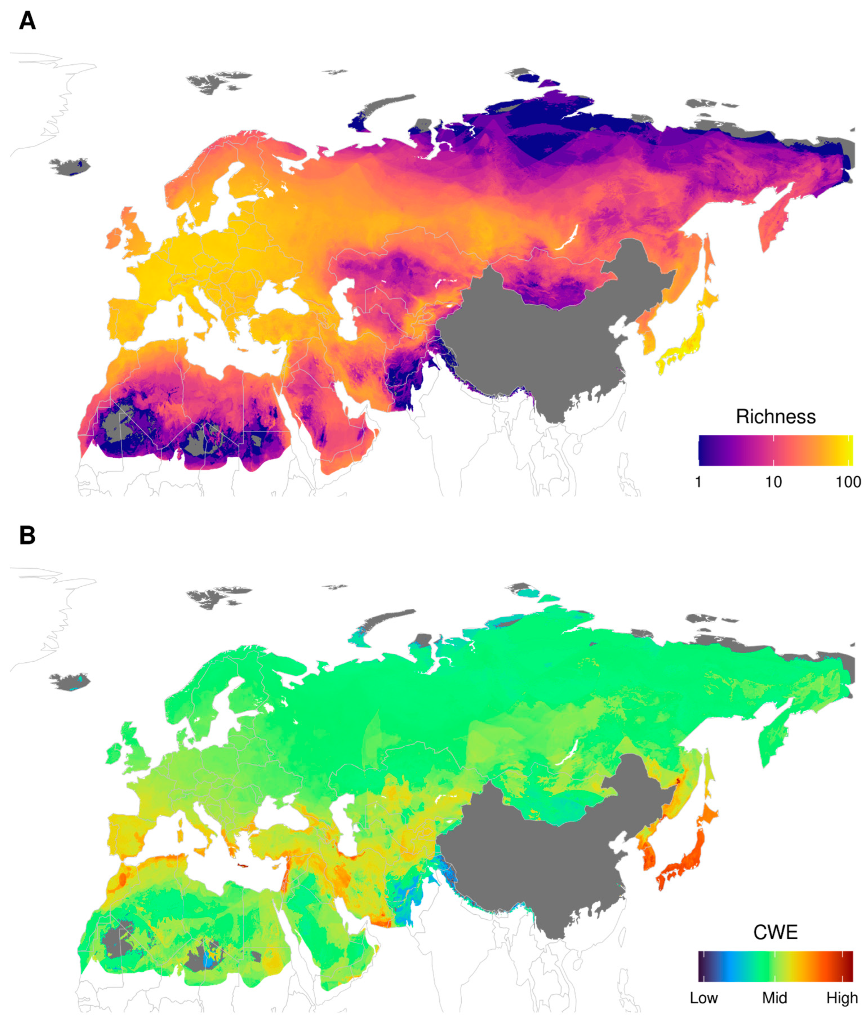
3.1. Richness and Corrected Weighted Endemism (CWE)

Figure 1A shows the patterns in total diversity based on data of the 402 Palaearctic species of dragonflies and damselflies. The map shows clear differences between regions with Europe, parts of the Middle East, and Japan and adjacent mainland Asia having the highest diversity compared with colder areas in the north and desert areas, such as the Sahara, parts of the Middle East, and the Gobi, which were less species-rich. The Corrected Weighted Endemism map (Figure 1B) is strikingly different from the map showing overall diversity, with hotspots being clearly centred in the Mediterranean, areas in Iran and in Japan, Korea, and Russia’s Far East.

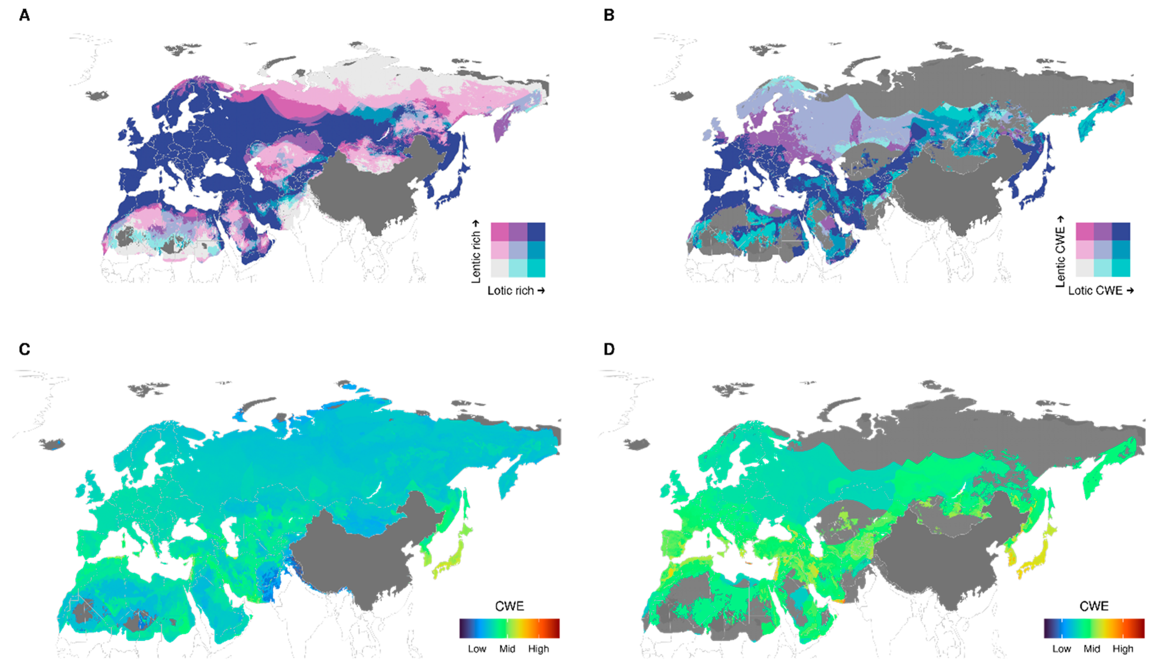
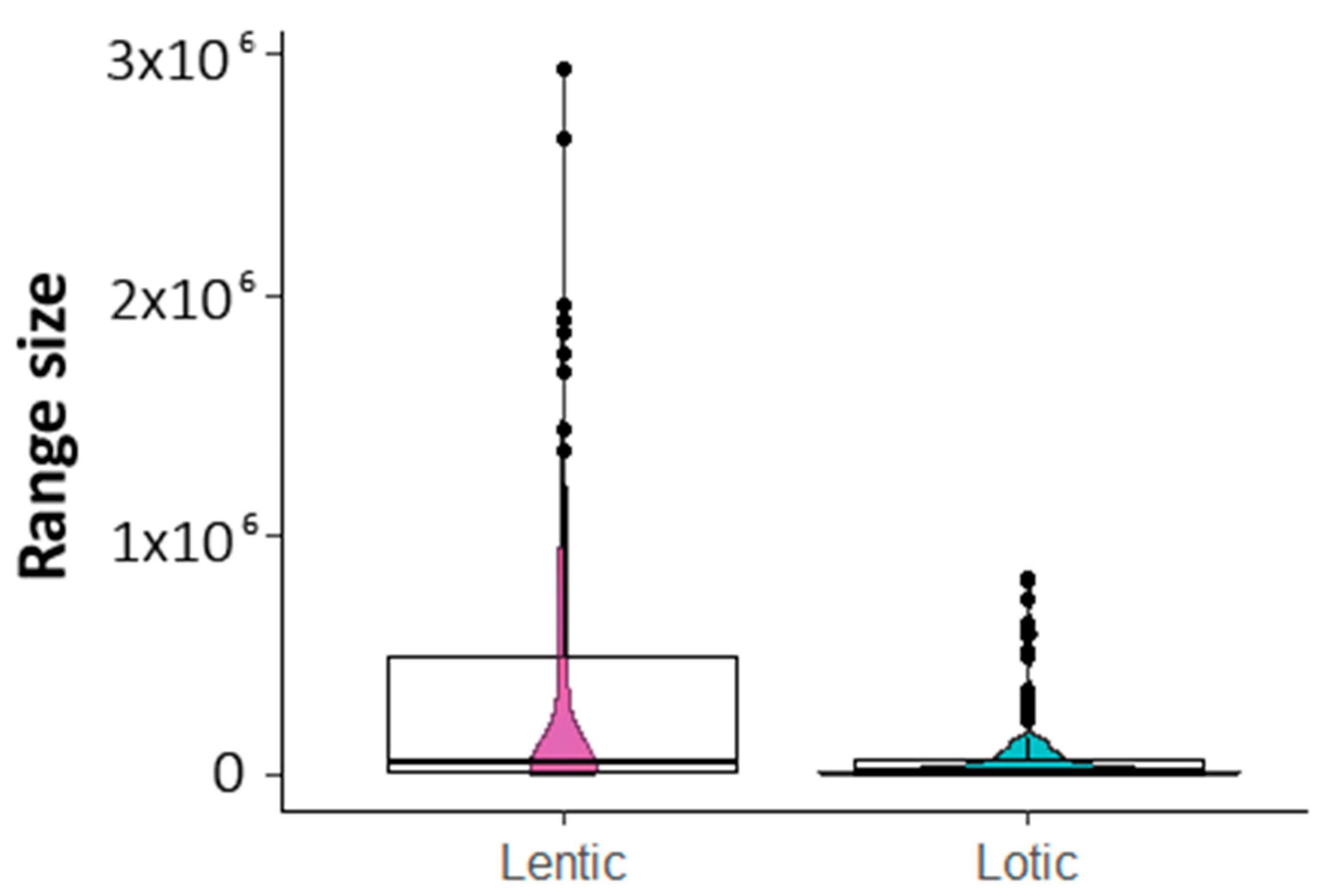
3.2. Richness and Endemism by Aquatic Habitats

Figure 2 shows that diversity patterns are clearly different between species of standing (lentic, 244 species) and running water (lotic, 158 species). Low diversity areas tend to be dominated by lentic species. This is true for both northern areas, which have a lower diversity due to the lower temperatures, as well as for the arid regions (Sahara, deserts of the Middle East, Central Asia, and the Gobi). Figure 2C,D, respectively, show the corrected weighted endemism for lentic and lotic species. The areas with a high CWE are more pronounced for those of lotic environments than for those of lentic environments. This is due to lotic species being more regionally concentrated and having smaller ranges than those of lentic environments (Figure 3, W = 24,254, p = 1.805 × 10⁻⁷).

3.3. Richness of Species According to IUCN Red List Category

Of the 402 species, 45 species have not yet been officially assessed for the IUCN Red List. Eleven of the 357 assessed species are Data Deficient, and 293 are of Least Concern. The distribution of the remaining 53 species is shown in Figure 4 (Critically Endangered, 2 species; Endangered, 20 species; Vulnerable, 12 species; Near Threatened, 19 species). The threatened species are clearly concentrated in three areas: (a) the western Mediterranean, (b) Iran, Turkey, the Southern Caucasus, and the Levant, and (c) Japan and Korean Peninsula (Figure 4). Of the 45 species not assessed, only 8 are likely to be in one of these categories, and all of these are from Japan or adjacent mainland so that their inclusion would not alter the general pattern.

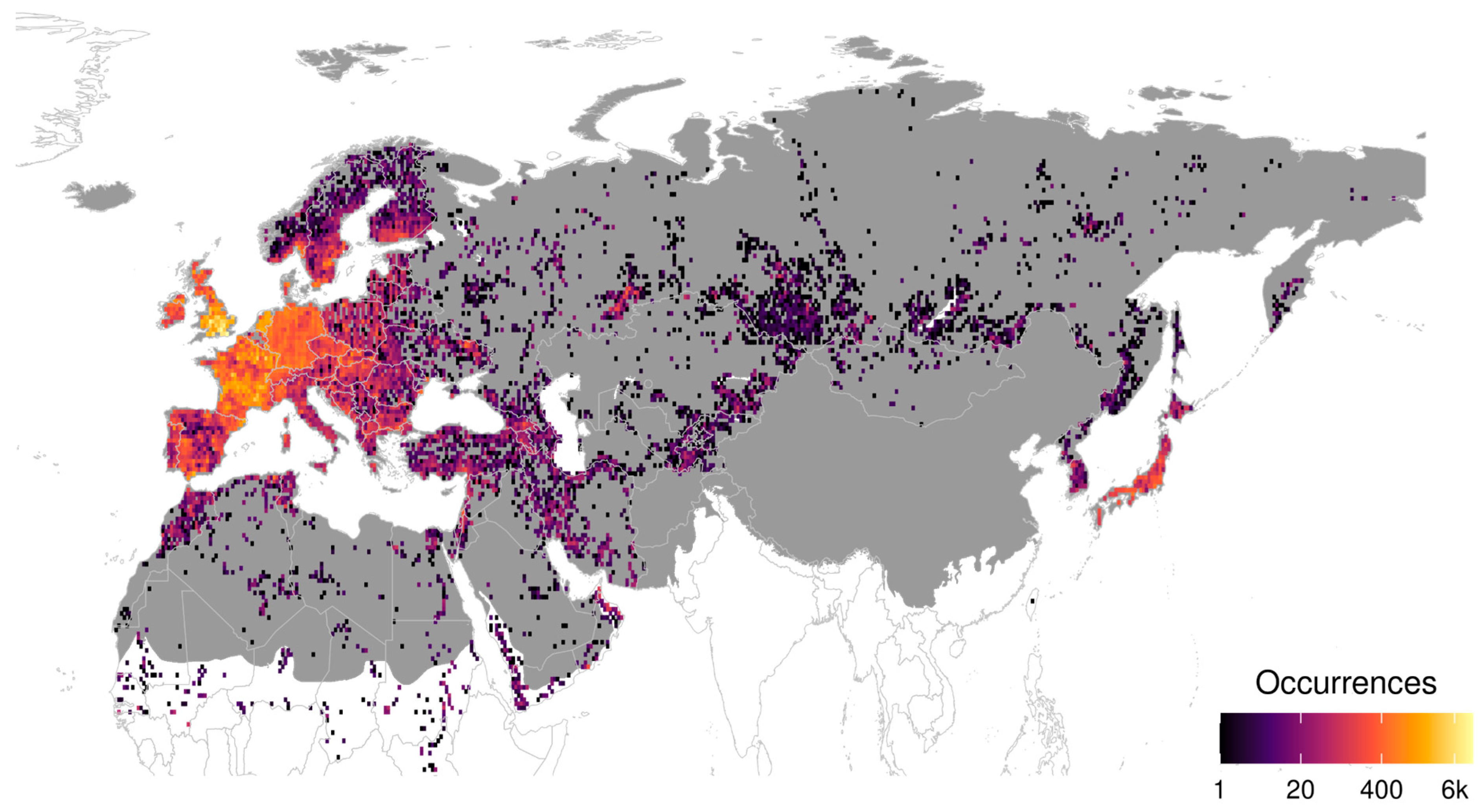
3.4. Sampling Effort

The distribution data is highly unevenly distributed across the Palaearctic with high densities of records available for Europe (although with strong regional differences) and Japan, while lower amounts of records available for North Africa, the Middle East, and West and Central Asia (Figure 5). Russia, Kazakhstan, and Mongolia are, on average, very poorly explored. For large areas of the latter three countries, which together cover almost 40 percent of the Palaearctic realm, none to a very few records are available and only small parts of these countries have been well explored (for instance, the southern Ural [32,33]. The methods used to make the SDMs partially compensate for this geographical imbalance, such that our maps reflect, to a large extent, actual richness patterns rather than sampling bias. However, it is also clear that sampling gaps are still an issue, and increasing field work is likely to show some of the low diversity areas, such as Kazakhstan, to be more diverse than the current map shows.

4. Discussion

4.1. General Diversity Patterns

The general diversity pattern shown in Figure 1 is correlated largely to temperature and precipitation. Higher temperature towards the south generally results in an increase in diversity, whereas lower temperature at higher altitudes results in a decrease in diversity. The former can be seen as a general pattern throughout the whole of the Palaearctic, while the latter can be observed in the lower diversity found in, for instance, the Alps, the highlands of Afghanistan, and parts of western Mongolia. This pattern of higher diversity in warmer areas is offset by low precipitation, which results in decreased diversity, examples of which can be seen in the Middle East and the central deserts of Iran. Figure 1 also shows a strong east–west (longitudinal) pattern, with areas in the central two-thirds of Palearctic being less diverse than areas to the east and west. For Europe, such a pattern was already described by [1,34] and it seems to be governed by the oceanic climate in the west of Europe transcending towards a continental climate farther east. The warm summer of the continental climate allows some species to occur farther north than in areas with an oceanic climate, but for many others, the stronger and longer winters in these areas is limiting their distribution. This can, for instance, be seen when comparing the fauna between the Netherlands and areas at a similar latitude to the south of Moscow. In the latter, many species common in west or central Europe are already absent (for example, Chalcolestes viridis, Pyrrhosoma nymphula, Ceriagrion tenellum, Erythromma lindenii, and Gomphus pulchellus). A similar pattern, although less obvious due to the absence of data from China, can be seen in the east of the Palaearctic. The relatively sharp contrast between the north and the south of the Caucasus is caused by this mountain range preventing cold air from penetrating farther south, resulting in mild winters to the south of the mountains. In Central Asia, a sharp contrast in diversity is visible between the arid lowlands and the mountains of the Kopet Dagh in northeast Iran and the mountains to the east of Tajikistan and Kyrgyzstan, caused by the higher precipitation in these mountain ranges. The diversity at species, generic, and family level is higher in the south of Japan than in areas at a similar latitude in the western Mediterranean. This is likely to be the result of the more humid climate of Japan, resulting in a higher diversity of freshwater habitats and the stronger impact of the glacial periods in the Western Palaearctic in combination with the Sahara, preventing tropical African lineages dispersing northwards.
In the western two-thirds of the Palaearctic, the borders with the Afrotropical and Oriental regions are formed by clear geographical barriers with the Sahara and the desert of the Arabian Peninsula, forming the demarcation with the Afrotropical region and the Himalaya, forming a well-marked boundary with the Oriental region. In the east, such a clear geographical barrier is absent, and it is, therefore, expected that the Palaearctic odonate fauna more gradually merges into the Oriental fauna, with isolated Palaearctic ‘islands’ expected to occur at higher elevations in southwest China. We currently lack the data to study this in detail, but the patterns shown in Korea and Japan give some insight. In both countries, a large portion of the fauna consists of species whose range is largely limited to the Palaearctic, often belonging to genera that themselves are also largely restricted to the Palearctic (for instance, Coenagrion, Aeshna, Somatochlora, and Sympetrum). In addition, however, there is a substantial number of genera whose distribution is centred on the Oriental region. In both countries, the north has a higher percentage of distinctly Palaearctic species, which is easiest to observe when comparing the fauna of Hokkaido, Japan’s northernmost Island, with that of Kyushu, the southernmost of Japan’s large islands. The indigenous Odonata fauna of Hokkaido (seven species) consist completely of species with a Palaearctic distribution largely from genera centred on the Palaearctic. In contrast, approximately 10 percent of the species found on the southern Kyushu are species restricted largely to the Oriental region. Despite this distinct difference between these two islands, there is no obvious demarcation line, and areas dominated by Palaearctic species just gradually merge into areas dominated by Oriental species. Further efforts examining phylogenetic beta diversity may provide a more resolved view of the regionalization of fauna and the historical forces that may have shaped such regions.

4.2. Are There Differences in Diversity Patterns Shown by Lotic and Lentic Species?

Figure 2 shows that diversity patterns of lotic and lentic species are not identical and show clear regional differences. The north of the Paleartic is dominated largely by lentic species (Figure 2A). This northern area dominated by lentic species reaches farther south in the eastern two-thirds of the Palaeartic, which might be correlated with the temperature in the east being lower than at comparable longitudes in the west. Arid regions, such as the Sahara, Middle East, parts of Kazakhstan and Central Asia, and the Gobi Desert, are also dominated by lentic species. Whereas the dominance of lentic species in arid regions is likely to be caused by the general scarcity of lotic habitats, the dominance of lentic species in the north seems to be caused by lotic habitats simply being too cold for most parts of the year. The CWE for lentic species shows a fairly uniform pattern, while that of the lotic species shows clear regions with higher diversity mostly found in the Mediterranean, southwest and central Asia and Japan and the Korean Peninsula. The differences between CWE shown by lentic and lotic species are the result of lotic species having smaller ranges (Figure 3), which matches the results found for the Nearctic [2] and supports the hypothesis that lotic species are more specialised insects [16,17] and, therefore, more susceptible to harsh or changing environmental conditions.

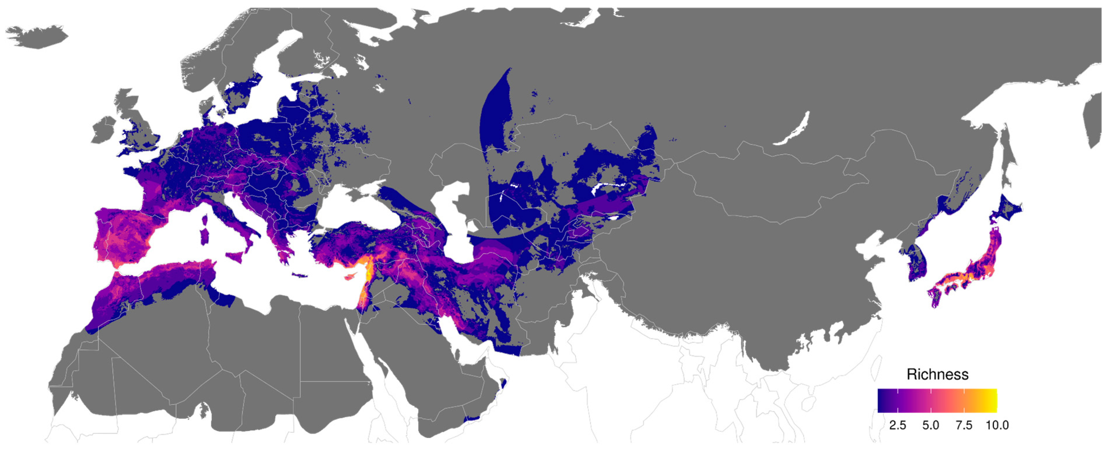
4.3. Are There Areas with Relatively High Endemism?

Figure 1B very clearly shows that there are marked regions with high endemism, with CWE being especially high in Japan and the Korean Peninsula. The Palaearctic part of Japan is home to approximately 130 species of which no less than 30 are endemic to the islands. Most of these are fairly widespread on the islands but, nonetheless, contribute to the high CWE of the islands. The high number of endemics is easily explained by the isolation of the main Japanese islands, but, surprisingly, the Korean Peninsula shows a CWE matching that of Japan. This suggests that the warm south of the peninsula is isolated from the rest of mainland Asia by the colder climate in the north of the peninsula.
The areas with high CWE in the Western Palaearctic are concentrated on the Mediterranean and the mountain regions of Turkey and Iran. All these areas match with known areas of endemism for odonates [34,35,36,37]. The Palaearctic part of the Arabian Peninsula lacks distinct areas of high CWE, with all endemics with small ranges being found largely in areas in Oman and Yemen that fall outside the Palaearctic, as redefined by [10]. Most of the north and the central part of the Palaearctic have a very low CWE, with most species having large ranges. In Central Asia, a slightly higher CWE can be noticed, resulting from the presence of a few species largely restricted to the mountains of Tian Shan and the Pamir Mountains [12].

4.4. Are There Areas with a Relatively High Percentage of Globally Threatened Species?

Figure 4 shows three regions with a high number of species listed as either Critically Endangered, Endangered, Vulnerable, or Near Threatened on the IUCN Red List: (a) the western Mediterranean, (b) Iran, Turkey, the Southern Caucasus, and the Levant, and (c) Japan and the Korean Peninsula. Not surprisingly, these areas are also the areas with the highest density of species, with a small range being endemic to the Palaearctic, resulting in the map of threatened species having a high congruence with the map showing the corrected weighted endemism (Figure 1B). Nearly all species found outside these areas have large ranges, often with a part of the range found in areas with relatively low human impact. For this reason, the northern two-thirds of the Palaearctic hardly has any species threatened on a global scale, although many of these species are likely declining at a regional scale [34,35]. Within the three regions with a high number of threatened species, two well-defined hot spots are visible: the Levant and the southern half of Japan. Each of these two have both a high number of species with a small range and are strongly impacted by human activities. In the case of the Levant, freshwater habitats in the coastal region are impacted by increased intake of water for consumption and agriculture, the construction of hydroelectric dams, gravel mining, and wastewater pollution [12]. Climate change is expected to have an additional deleterious effect as the area is predicted to become both hotter and drier. In Japan, insecticides and the impact of alien species have in recent years become important factors in the decline of species [38].

5. Further Research

This paper provides a description for the patterns of diversity of dragonflies and damselflies found in the Palaearctic region and an overview of possible explanations for these patterns. The data on which the maps presented in this paper are based, together with the increasingly available molecular data, provide a valuable source of data for further studies focused on describing and understanding diversity patterns of dragonflies and damselflies in the Palaearctic. The possibilities for such studies are further increased by the availability of a similar set of data for the Nearctic region [2]. In order to understand the historical and contemporary factors determining the patterns of diversity in more detail, the following studies are deemed the most relevant:
Limits between Oriental and Palaearctic regions. In the western two-thirds of the Palaearctic, the border with the Afrotropical and the Oriental regions is formed by well-defined geographical barriers such as the Sahara and the Himalayas. In the east, no such clear barriers exist between the Palaearctic and Oriental regions. In a recent review of freshwater bioregions in China, Huang et al. [39] placed the border between the Palaearctic and the Oriental region on the line between the Qin Mountains of southern Shaanxi to the mouth of the Yangtze River. Expanding our database with data from China will allow us to test whether a clear demarcation line between the two faunas really exists in China or whether that is a large area where the fauna gradually turns over. Furthermore, such data can be used to establish which mountain ranges in southwest China have a clearly Palearctic fauna.
Establishing the timing and direction of exchange between the Palaearctic and the Nearctic. More than 40 percent of the 402 Odonata species occurring in the Palearctic belong to genera also occurring in the Nearctic. It is likely that many of these genera crossed from the Nearctic to the Palaearctic or vice versa. It is unknown whether these dispersal events were predominantly in one direction or to what extent these dispersal events were succeeded by rapid speciation. An analysis of haplotypes of five species shared between the Nearctic and Palaearctic indicated that dispersal though Beringia went both ways, with the data indicating that the populations of the continents have been separated for more than 400,000 years [40]. Molecular data and associated bio- and phylogeographic studies leveraging distribution models presented here and in [2] can help determine which parts of diversity originated from dispersal events and subsequent speciation between both parts of the Holarctic.
Locating and dating glacial refugia. One potential next step now that distribution models are available for all species is to backcast distributions to the Last Glacial Maximum. Backcasts have often been used to locate pleistocene refugial area, and these have often been confirmed with molecular techniques [41]. However, most studies have focused on only a few species, and here the possibility to simultaneously backcast all palearctic dragonflies might provide a novel means to establish fauna-wide refugia locations. For example, our results show a centre of endemism concentrated in the Mediterranean region, especially in Morocco and Tunisia in North Africa, which may indicate an area of long-term climate stability that could also serve as a refugium [42,43]. Combining such approaches with time-calibrated trees and population genetic data, provides a means to understanding the timing of formation of refugia and recolonization dynamics from those locales.
Modelling the expected impact of climate change. Climate change is already having a substantial impact on the distribution of species, but at present, evidence for this is restricted largely to the best-investigated regions of the Palaearctic. Studies on shifts in distribution and changes in phenology in the Palaearctic are almost exclusively from north and western Europe (e.g., [17,44,45,46,47] and Japan [48,49]. The data at hand would allow us to determine climatological envelopes for species for different climatological scenarios and different time periods. Developing these scenarios is of importance for conservation planning but would also allow us to determine whether climate change will allow species to break through their biogeographical boundaries, which would, for instance, happen when climate change facilitates an eastwards jump of Western Palaearctic species and vice versa.

Supplementary Materials

The following supporting information can be downloaded at: https://www.mdpi.com/article/10.3390/d14110966/s1, Supplementary Table S1. List of the Odonata species recorded in the Palaearctic (as defined in this paper), with their IUCN conservation status, their terrestrial and aquatic habitat. En: endangered, LC: least concern, NA: not assessed, NT: near-threatened, Vu: vulnerable.

Author Contributions

Conceptualization, V.J.K., J.C.A., C.A.B.-S., R.G. and S.M.B.; methodology, J.C.A., C.A.B.-S., R.G., V.J.K. and S.M.B.; software, R.G. and M.W.B.; validation, V.J.K., J.-P.B. and R.F.; formal analysis, V.J.K., J.C.A., C.A.B.-S., R.G. and M.W.B.; data curation, J.-P.B., R.F. and V.J.K.; writing—original draft preparation, V.J.K., J.-P.B., R.F., J.C.A., C.A.B.-S., R.G., S.M.B., J.W. and M.W.B.; writing—review and editing, V.J.K., J.-P.B., R.F., J.C.A., C.A.B.-S., R.G., S.M.B., J.W. and M.W.B.; project administration, J.C.A., R.G., S.M.B. and J.W.; funding acquisition, J.C.A., R.G., S.M.B. and J.W. Contribution to databases: J.-P.B. and R.F. All authors have read and agreed to the published version of the manuscript.

Funding

This work was supported by NSF Awards (Abbott: 2002489; Ware: 2002473; Bybee: 2002432; Guaralnick: 2002457), Genealogy of Odonata (GEODE): Dispersal and color as drivers of 300 million years of global dragonfly evolution.

Institutional Review Board Statement

Not applicable.

Informed Consent Statement

Not applicable.

Data Availability Statement

Data are provided below and in Supplementary Table S1. The composite richness and endemism values for each cell (released as CSV); the composite richness and endemism values for each cell broken out by trait (lentic, lotic; released as 2 CSVs) are available from a Zenodo repository (https://doi.org/10.5281/zenodo.7195870; accessed on 13 October 2022). Species-specific SDMs showing the predicted areas of presence for each species released as a single zip file are available at (https://osf.io/szqkw/) DOI 10.17605/OSF.IO/SZQKW (accessed on 15 September 2022).

Conflicts of Interest

The authors declare no conflict of interest.

References

  1. Wasscher, M.T.; Bos, F.G. The European dragonflies: Notes on the checklist and on species diversity. Odonatologica 2000, 29, 31–43. [Google Scholar]
  2. Abbott, J.C.; Bota-Sierra, C.A.; Guralnick, R.; Kalkman, V.; González-Soriano, E.; Novelo-Gutiérrez, R.; Bybee, S.; Ware, J.; Belitz, M.W. Diversity of Nearctic Dragonflies and Damselflies (Odonata). Diversity 2022, 14, 575. [Google Scholar] [CrossRef]
  3. Boudot, J.-P.; Kalkman, V.J. Atlas of the European Dragonflies and Damselflies; KNNV-Publishing: Utrecht, The Netherlands, 2015. [Google Scholar]
  4. Clausnitzer, V.; Dijkstra, K.-D.B.; Koch, R.; Boudot, J.-P.; Darwall, W.R.T.; Kipping, J.; Samraoui, B.; Samways, M.J.; Simaika, J.P.; Suhling, F. Focus on African Freshwaters: Hotspots of dragonfly diversity and conservation concern. Front. Ecol. Environ. 2012, 10, 129–134. [Google Scholar] [CrossRef]
  5. Endersby, I. The Distribution of Australian Dragonflies; Busybird Publishing: Montmorency, VIC, Australia, 2021. [Google Scholar]
  6. Kalkman, V.J.; Boudot, J.P.; Bernard, R.; De Knijf, G.; Suhling, F.; Termaat, T. Diversity and conservation of European dragonflies and damselflies (Odonata). Hydrobiologia 2018, 811, 269–282. [Google Scholar] [CrossRef] [Green Version]
  7. Darwall, W.R.T.; Smith, K.G.; Allen, D.J.; Holland, R.A.; Harrison, I.J.; Brooks, E.G.E. (Eds.) The Diversity of Life in African Freshwaters: Under Water, under Threat. An Analysis of the Status and Distribution of Freshwater Species throughout Mainland Africa; IUCN: Cambridge, UK; Gland, Switzerland, 2011. [Google Scholar]
  8. Combe, F.J.; Sikes, D.S.; Tkach, V.V.; Hope, A.G. Origins and diversity of the Bering Sea Island fauna: Shifting linkages across the northern continents. Biodivers. Conserv. 2021, 30, 1205–1232. [Google Scholar] [CrossRef]
  9. Wen, J.; Nie, Z.-L.; Ickert-Bond, S.M. Intercontinental disjunctions between eastern Asia and western North America in vascular plants highlight the biogeographic importance of the Bering land bridge from late Cretaceous to Neogene. J. Syst. Evol. 2016, 54, 469–490. [Google Scholar] [CrossRef]
  10. Olson, D.M.; Dinerstein, E.; Wikramanayake, E.D.; Burgess, N.D.; Powell, G.V.N.; Underwood, E.C.; D’amico, J.; Itoua, I.; Strand, H.E.; Morrison, J.C.; et al. Terrestrial Ecoregions of the World: A New Map of Life on Earth. BioScience 2001, 51, 933–938. [Google Scholar] [CrossRef]
  11. Boudot, J.-P.; Kalkman, V.J.; Azpilicueta Amorin, M.; Bogdanović, T.; Cordero Rivera, A.; Degabriele, G.; Dommanget, J.-L.; Ferreira, S.; Garrigós, B.; Jović, M.; et al. Atlas of the Odonata of the Mediterranean and North Africa. Libellula Suppl. 2009, 9, 1–256. [Google Scholar]
  12. Boudot, J.P.; Borisov, S.; De Knijf, G.; Grunsven, R.H.A.; van Schröter, A.; Kalkman, V.J. Atlas of the dragonflies and damselflies of West and Central Asia. Brachytron Suppl. 2021, 22, 3–248. [Google Scholar]
  13. National Biodiversity Center of Japan, Ministry of the Environment, Japan, Tokyo. Data from: The National Survey on the Natural Environment Report of the Distributional Survey of Japanese Animals (Dragonflies). 2002. Available online: http://www.biodic.go.jp/reports/4-09/h000.html (accessed on 21 January 2021).
  14. Ozono, A.; Kawashima, I.; Futahashi, R. Dragonflies of Japan, Revised ed.; Bun-ichi Sogo Shuppan Co.: Tokyo, Japan, 2021. [Google Scholar]
  15. Zizka, A.; Silvestro, D.; Andermann, T.; Azevedo, J.; Duarte Ritter, C.; Edler, D.; Farooq, H.; Herdean, A.; Ariza, M.; Scharn, R.; et al. CoordinateCleaner: Standardized Cleaning of Occurrence Records from Biological Collection Databases. Methods Ecol. Evol. 2019, 10, 744–751. [Google Scholar] [CrossRef]
  16. Hof, C.; Brändle, M.; Brandl, R. Lentic Odonates Have Larger and More Northern Ranges than Lotic Species. J. Biogeogr. 2006, 33, 63–70. [Google Scholar] [CrossRef]
  17. Olsen, K.; Svenning, J.-C.; Balslev, H. Niche Breadth Predicts Geographical Range Size and Northern Range Shift in European Dragonfly Species (Odonata). Diversity 2022, 14, 719. [Google Scholar] [CrossRef]
  18. Davis Rabosky, A.R.; Cox, C.L.; Rabosky, D.L.; Title, P.O.; Holmes, I.A.; Feldman, A.; McGuire, J.A. Coral Snakes Predict the Evolution of Mimicry across New World Snakes. Nat. Commun. 2016, 7, 11484. [Google Scholar] [CrossRef] [PubMed] [Green Version]
  19. Barve, N.; Barve, V.; Jiménez-Valverde, A.; Lira-Noriega, A.; Maher, S.P.; Peterson, A.T.; Soberón, J.; Villalobos, F. The Crucial Role of the Accessible Area in Ecological Niche Modeling and Species Distribution Modeling. Ecol. Model. 2011, 222, 1810–1819. [Google Scholar] [CrossRef]
  20. Steen, V.A.; Elphick, C.S.; Tingley, M.W. An Evaluation of Stringent Filtering to Improve Species Distribution Models from Citizen Science Data. Divers. Distrib. 2019, 25, 1857–1869. [Google Scholar] [CrossRef]
  21. Hijmans, R.J. Package ‘Raster’—Geographic Data Analysis and Modeling; CRAN Repos. 2019. Available online: https://rspatial.org/raster (accessed on 10 May 2022).
  22. Phillips, S.J.; Anderson, R.P.; Dudík, M.; Schapire, R.E.; Blair, M.E. Opening the Black Box: An Open-Source Release of Maxent. Ecography 2017, 40, 887–893. [Google Scholar] [CrossRef]
  23. Hijmans, R.J.; Phillips, S.; Leathwick, J.; Elith, J. Dismo: Species Distribution Modeling; R Package Version 1.1-4; Cran. 2017. Available online: https://cran.r-project.org/web/packages/dismo/dismo.pdf (accessed on 10 May 2022).
  24. Merow, C.; Smith, M.J.; Silander, J.A. A Practical Guide to MaxEnt for Modeling Species’ Distributions: What It Does, and Why Inputs and Settings Matter. Ecography 2013, 36, 1058–1069. [Google Scholar] [CrossRef]
  25. Fick, S.E.; Hijmans, R.J. WorldClim 2: New 1-Km Spatial Resolution Climate Surfaces for Global Land Areas. Int. J. Climatol. 2017, 37, 4302–4315. [Google Scholar] [CrossRef]
  26. Naimi, B.; Hamm, N.A.S.; Groen, T.A.; Skidmore, A.K.; Toxopeus, A.G. Where Is Positional Uncertainty a Problem for Species Distribution Modelling? Ecography 2014, 37, 191–203. [Google Scholar] [CrossRef]
  27. Kass, J.M.; Muscarella, R.; Galante, P.J.; Bohl, C.L.; Pinilla-Buitrago, G.E.; Boria, R.A.; Soley-Guardia, M.; Anderson, R.P. ENMeval 2.0: Redesigned for Customizable and Reproducible Modeling of Species’ Niches and Distributions. Methods Ecol. Evol. 2021, 12, 1602–1608. [Google Scholar] [CrossRef]
  28. Calabrese, J.M.; Certain, G.; Kraan, C.; Dormann, C.F. Stacking Species Distribution Models and Adjusting Bias by Linking Them to Macroecological Models. Glob. Ecol. Biogeogr. 2014, 23, 99–112. [Google Scholar] [CrossRef]
  29. González-Orozco, C.E.; Laffan, S.W.; Miller, J.T. Spatial Distribution of Species Richness and Endemism of the Genus Acacia in Australia. Aust. J. Bot. 2011, 59, 601–609. [Google Scholar] [CrossRef]
  30. Earl, C.; Belitz, M.W.; Laffan, S.W.; Barve, V.; Barve, N.; Soltis, D.E.; Allen, J.M.; Soltis, P.S.; Mishler, B.D.; Kawahara, A.Y.; et al. Spatial phylogenetics of butterflies in relation to environmental drivers and angiosperm diversity across North America. iScience 2021, 24, 102239. [Google Scholar] [CrossRef] [PubMed]
  31. Sandall, E.L.; Pinkert, S.; Jetz, W. Country-level checklists and occurrences for the world’s Odonata (dragonflies and damselflies). J. Biogeogr. 2022, 49, 1586–1598. [Google Scholar] [CrossRef]
  32. Yanybaeva, V.A.; Dumont, H.J.; Haritonov, A.Y.; Popova, O.N. The Odonata of the South Ural, Russia, with special reference to Ischnura aralensis Haritonov, 1979. Odonatologica 2006, 35, 167–185. [Google Scholar]
  33. Haritonov, A.Y.; Eremina, E.E. The dragonflies (Odonata) of South Ural: The value of regional faunistic research. Euroasian Entomol. J. 2010, 9, 263–273. [Google Scholar]
  34. Kalkman, V.J.; Boudot, J.-P.; Bernard, R.; Conze, K.-J.; De Knijf, G.; Dyatlova, E.; Ferreira, S.; Jović, M.; Ott, J.; Riservato, E.; et al. European Red List of Dragonflies; IUCN: Gland, Switzerland; Cambridge, UK; Office for Official Publications of the European Communities: Luxembourg, 2010. [Google Scholar]
  35. Riservato, E.; Boudot, J.-P.; Ferreira, S.; Jović, M.; Kalkman, V.J.; Schneider, W.; Samraoui, B.; Cuttelod, A. The Status and Distribution of Dragonflies of the Mediterranean Basin; IUCN Red List of Threatened Species, Regional Assessments Series; IUCN: Gland, Switzerland; Malaga, Spain, 2009. [Google Scholar]
  36. Samraoui, B.; Boudot, J.-P.; Ferreira, S.; Riservato, E.; Jović, M.; Kalkman, V.J.; Schneider, W. The Status and Distribution of Dragonflies (Odonata). In The Status and Distribution of Freshwater Biodiversity in Northern Africa; IUCN Red List of Threatened Species, Regional Assessments Series; Garcia, N., Cuttelod, A., Abdul Malak, D., Eds.; IUCN: Gland, Switzerland; Malaga, Spain, 2010; Chapter 5; pp. 51–70. [Google Scholar]
  37. Kosterin, O.; Malikova, E.I.; Haritonov, A.Y. Critical species of Odonata in the Asian part of the former USSR and the Republic of Mongolia. Int. J. Odonatol. 2004, 7, 341–370. [Google Scholar] [CrossRef]
  38. Karube, H. Conservation of endangered dragonflies. Nat. Insects 2020, 55, 2–3. [Google Scholar]
  39. Huang, C.; Ebach, M.; Ahyong, S.T. Bioregionalisation of the freshwater zoogeographical areas of mainland China. Zootaxa 2020, 4742, 271–298. [Google Scholar] [CrossRef]
  40. Kohli, M.; Djernæs, M.; Sanchez Herrera, M.; Sahlen, G.; Pilgrim, E.; Simonsen, T.J.; Olsen, K.; Ware, J. Comparative phylogeography uncovers evolutionary past of Holarctic dragonflies. PeerJ 2021, 9, e11338. [Google Scholar] [CrossRef]
  41. Waltari, E.; Hijmans, R.J.; Peterson, A.T.; Nyári, A.S.; Perkins, S.L.; Guralnick, R.P. Locating Pleistocene Refugia: Comparing Phylogeographic and Ecological Niche Model Predictions. PLoS ONE 2007, e563. [Google Scholar] [CrossRef] [PubMed] [Green Version]
  42. Husemann, M.; Schmitt, T.; Zachos, F.E.; Ulrich, W.; Habel, J.C. Palaearctic biogeography revisited: Evidence for the existence of a North African refugium for Western Palaearctic biota. J Biogeogr. 2014, 41, 81–94. [Google Scholar] [CrossRef]
  43. Harrison, S.; Noss, R. Endemism hotspots are linked to stable climatic refugia. Ann Bot. 2017, 119, 207–214. [Google Scholar] [CrossRef]
  44. De Knijf, G.; Flenker, U.; Vanappelghem, C.; Manci, C.O.; Kalkman, V.J.; Demolder, H. The status of two boreo-alpine species, Somatochlora alpestris and S. arctica, in Romania and their vulnerability to the impact of climate change (Odonata: Corduliidae). Int. J. Odonatol. 2011, 14, 111–126. [Google Scholar] [CrossRef]
  45. Dingemanse, N.J.; Kalkman, V.J. Changing temperature regimes have advanced the phenology of Odonata in the Netherlands. Ecol. Entomol. 2008, 33, 394–402. [Google Scholar] [CrossRef]
  46. Hickling, R.; Roy, D.B.; Hill, J.K.; Thomas, C.D. A northward shift of range margins in British Odonata. Glob. Change Biol. 2005, 11, 502–506. [Google Scholar] [CrossRef]
  47. Hassall, C.; Thompson, D.J.; French, G.C.; Harvey, I.F. Historical changes in the phenology of British Odonata are related to climate. Glob. Change Biol. 2007, 13, 933–941. [Google Scholar] [CrossRef]
  48. Doi, H. Delayed phenological timing of dragonfly emergence in Japan over five decades. Biol. Lett. 2008, 4, 388–391. [Google Scholar] [CrossRef]
  49. Aoki, T. Northward expansion of Ictinogomphus pertinax (Selys, 1854) in Japan. Nat. Insects 2021, 56, 12–17. [Google Scholar]
Figure 1. (A) Distribution of Odonata richness and (B) corrected weighted endemism (CWE) of Palaearctic odonates. Grey shading indicates the parts of the Palearctic for which our data are insufficient to make predictions.
Diversity 14 00966 g001
Figure 2. Species richness and corrected weighted endemism for aquatic habitats used by odonate species in the Palaearctic. (A) Bivariate plot showing distribution of richness for lotic-dependent and lentic species; (B) bivariate plot showing distribution of corrected weighted endemism (CWE) for lotic-dependent and lentic species; (C) corrected weighted endemism (CWE) for lentic species; and (D) corrected weighted endemism (CWE) for lotic-dependent species.
Diversity 14 00966 g002
Figure 3. Range size (defined by the number of cells with predicted presence) for lentic- and lotic-dependent Odonata species.
Diversity 14 00966 g003
Figure 4. Distribution of the species richness for the IUCN Red List category Critically Endangered (2), Endangered (19), Vulnerable (12), or Near Threatened (16).
Diversity 14 00966 g004
Figure 5. Odonata sampling effort in the Palaearctic.
Diversity 14 00966 g005
Table 1. Description of predictor variables included in our SDM modelling framework and the mean permutation contribution of each variable averaged across all of our top models.
Bioclimatic VariableDescriptionMean Permutation Contribution
Bio 2Mean diurnal range 15.8
Bio 4Temperature seasonality12.0
Bio 1Annual mean temperature11.6
Bio 5Max. temperature of warmest month10.7
Bio 15Precipitation seasonality9.2
Bio 8Mean temperature of wettest quarter7.2
Bio 9Mean temperature of driest quarter6.9
Bio 13Precipitation of wettest month5.7
Bio 12Annual precipitation5.3
Bio 6Min. temperature of coldest month5.1
Bio 14Precipitation of driest month4.5
Bio 17Precipitation of driest quarter3.2
Bio 16Precipitation of wettest quarter2.8
Publisher’s Note: MDPI stays neutral with regard to jurisdictional claims in published maps and institutional affiliations.

