
Landslide Susceptibility Mapping in Brazil: A Review


Abstract
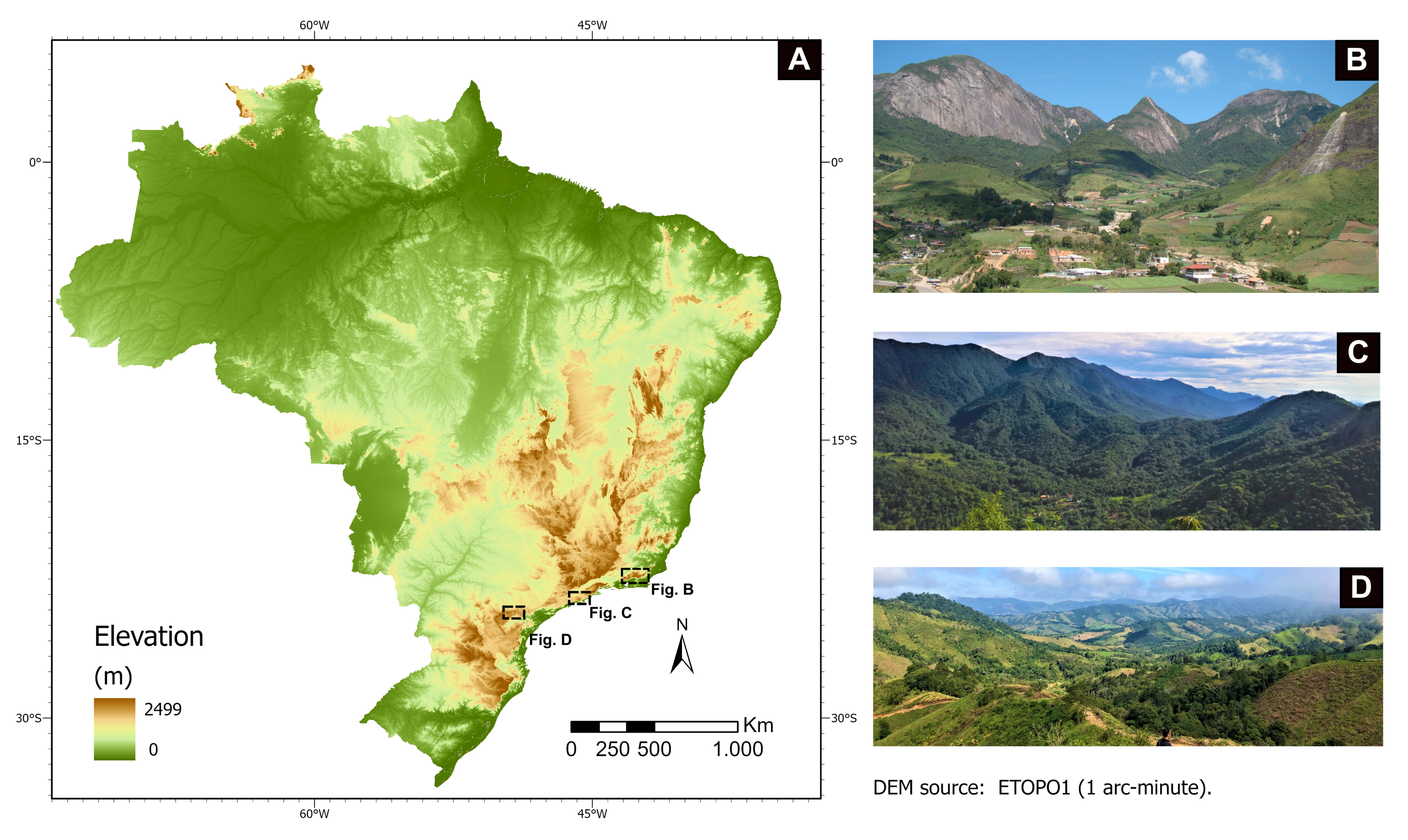
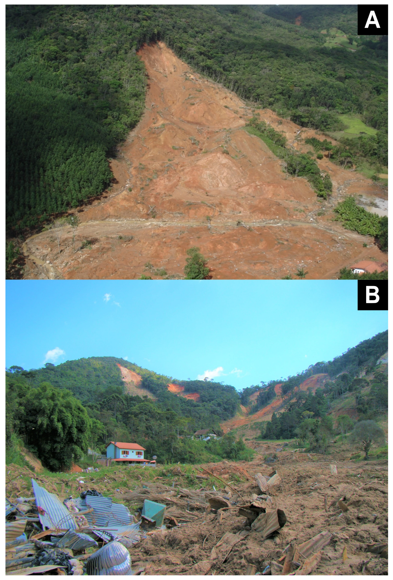
:1. Introduction
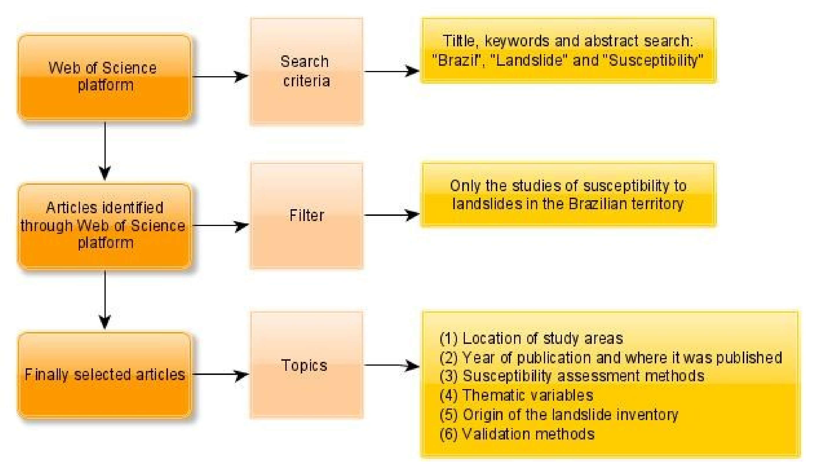
2. Materials and Methods
3. Results and Discussion
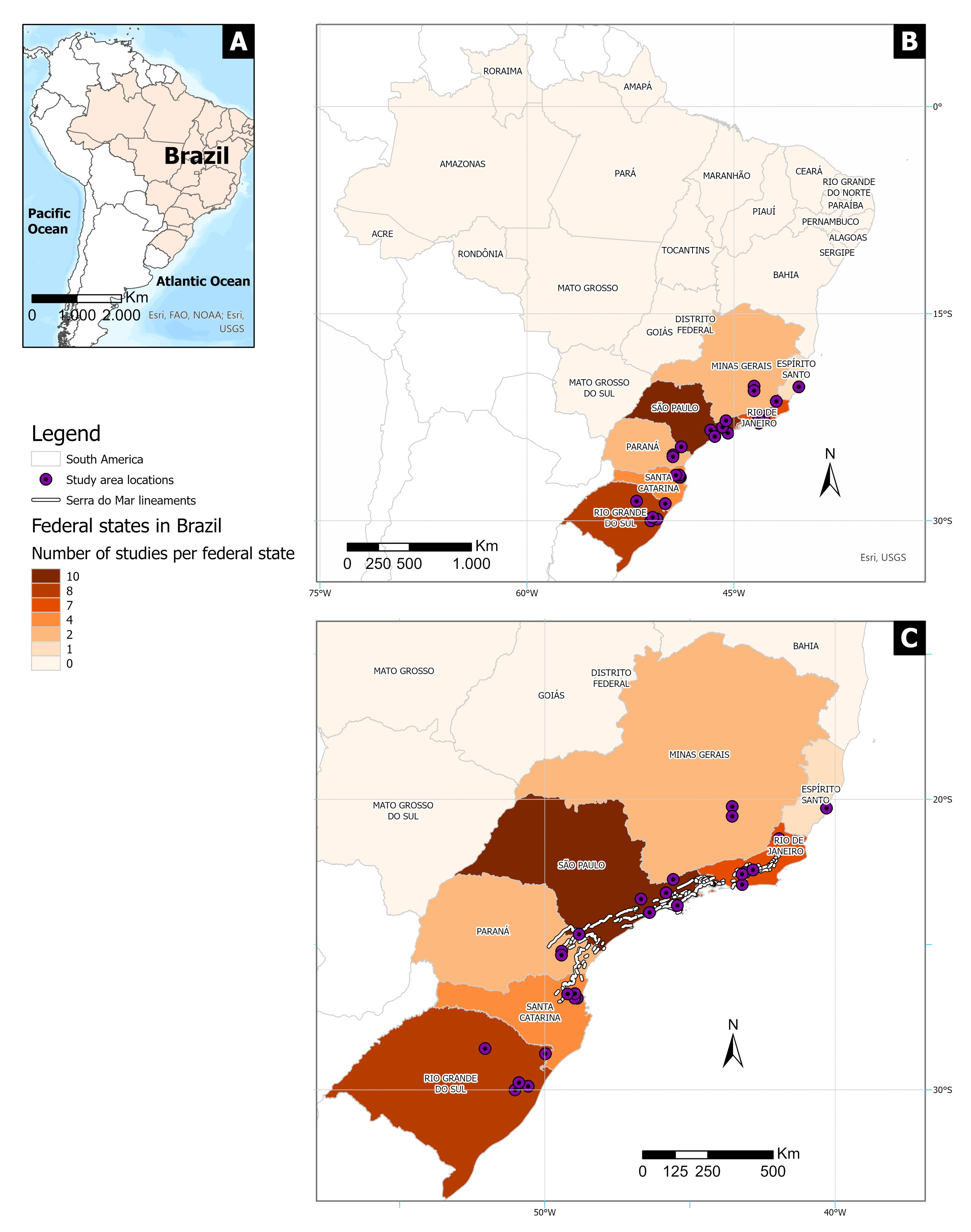
3.1. Location of Study Areas
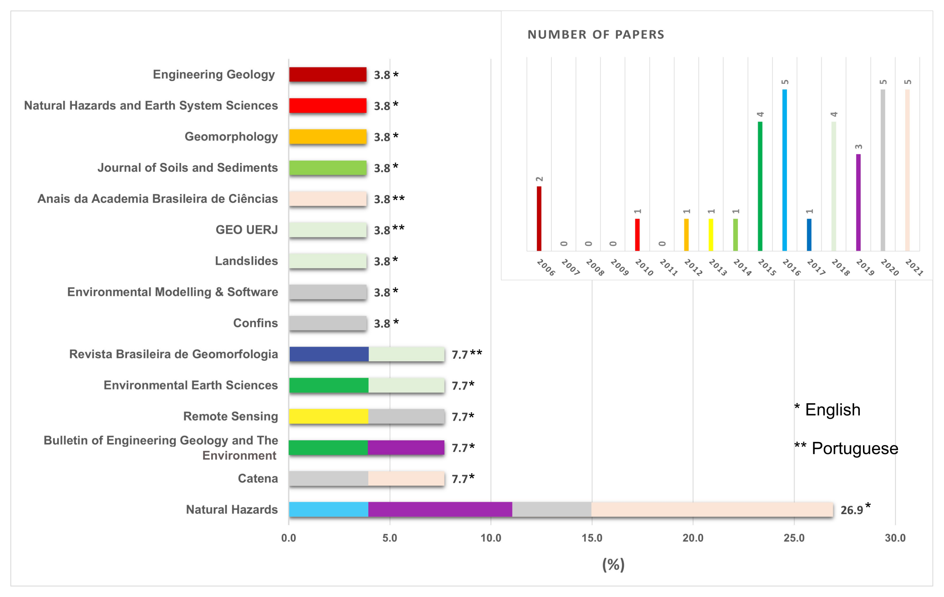
3.2. Year of Publication and Where It Was Published
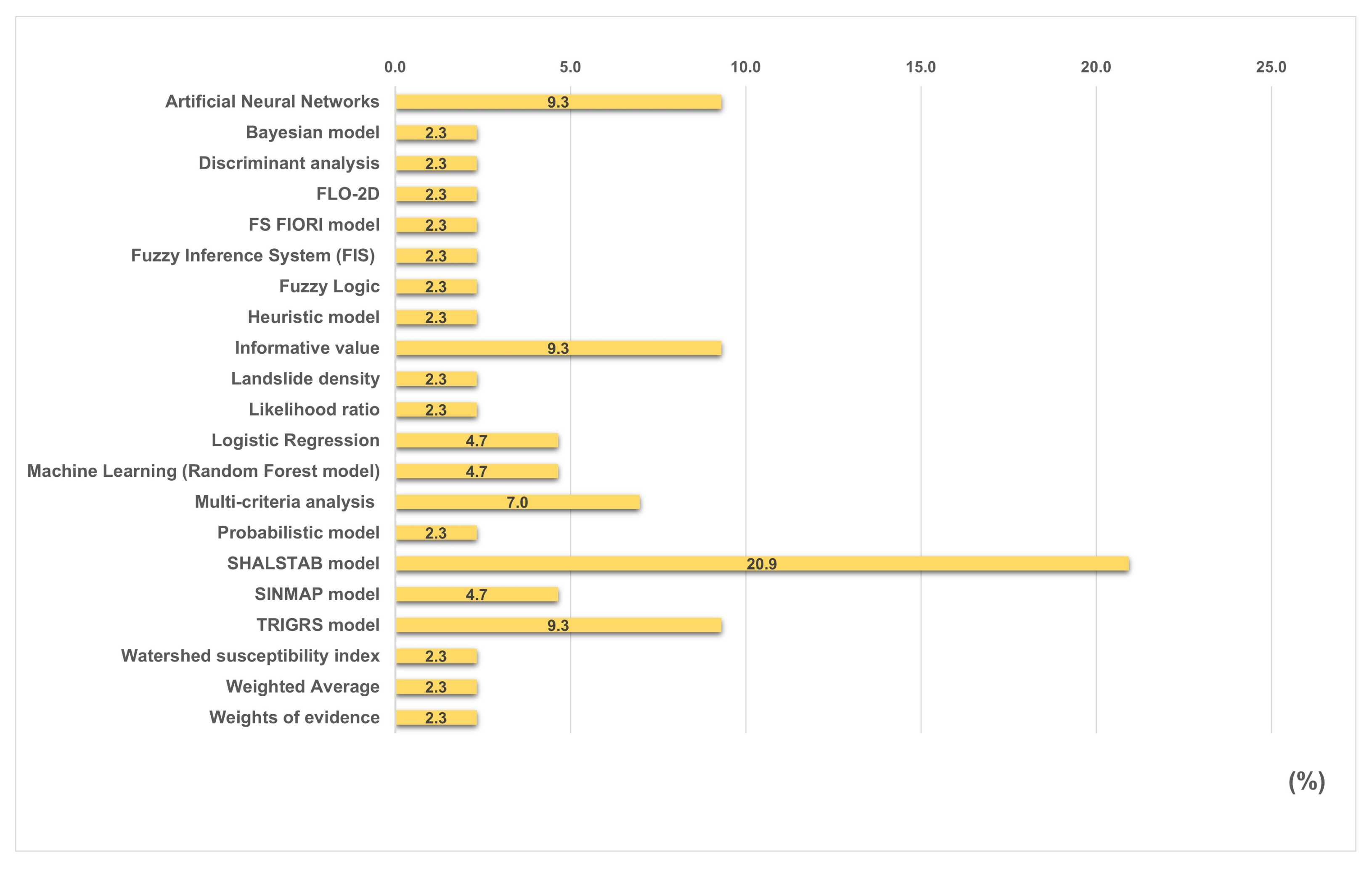
3.3. Susceptibility Assessment Methods
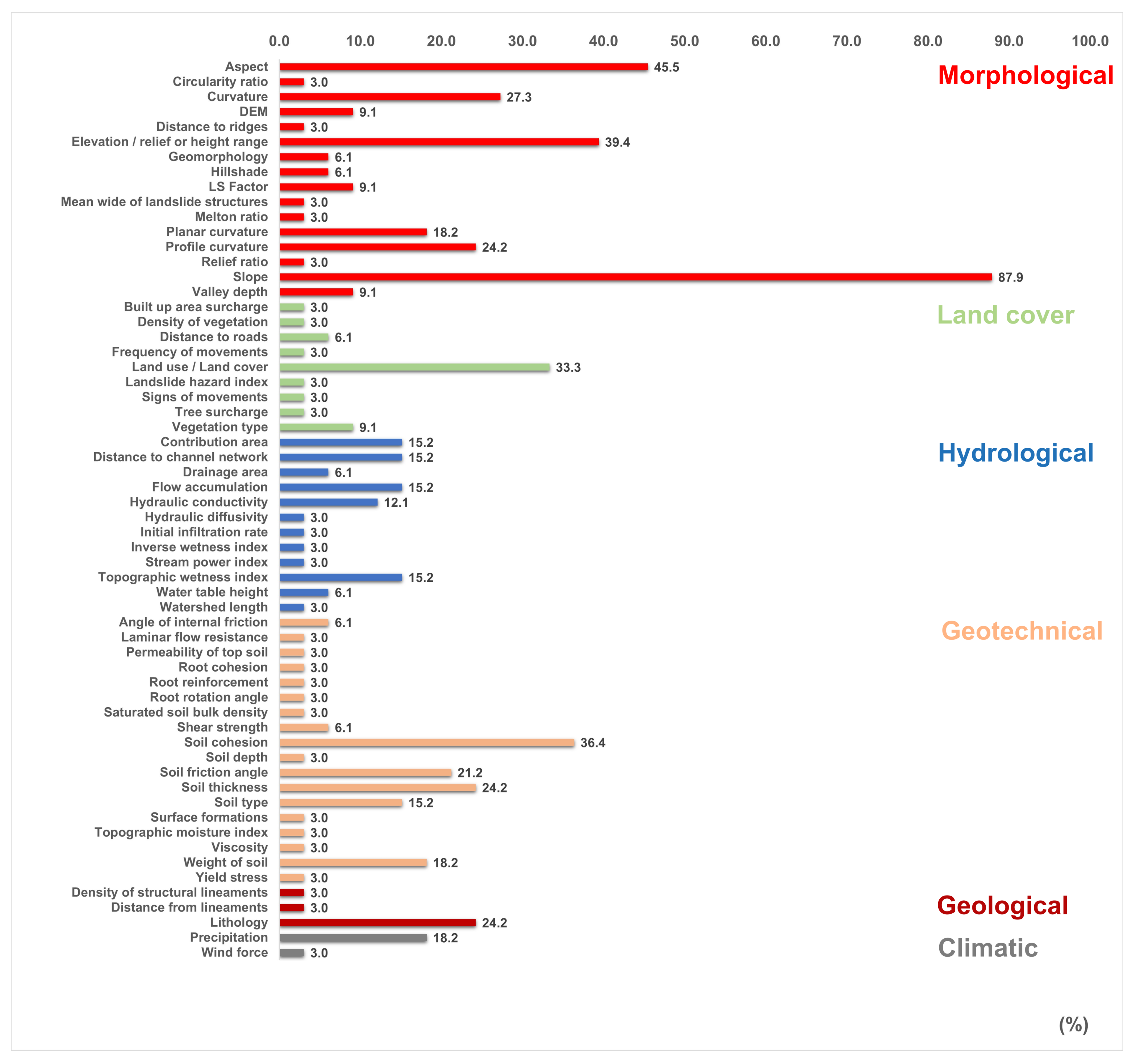
3.4. Thematic Variables
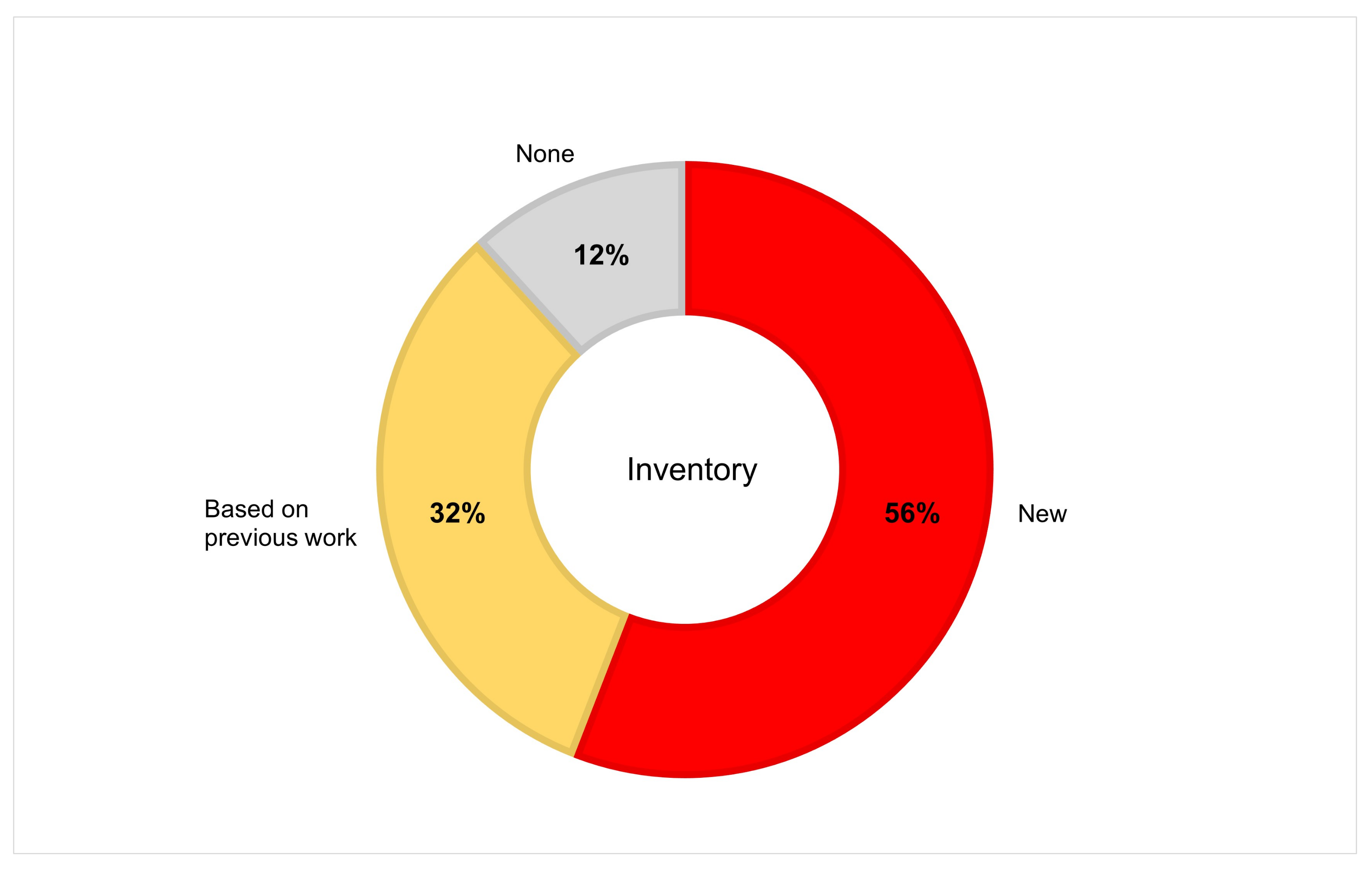
3.5. Origin of the Landslide Inventory
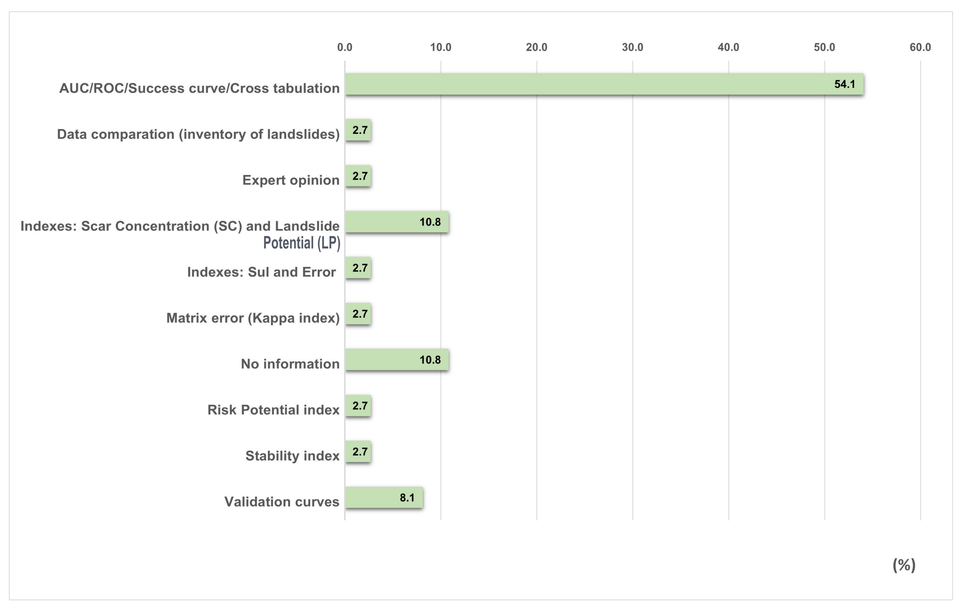
3.6. Validation Methods
4. Conclusions
Author Contributions
Funding
Institutional Review Board Statement
Informed Consent Statement
Data Availability Statement
Acknowledgments
Conflicts of Interest
Abbreviations
| AUC | Area Under the Curve |
| CEMADEN | Brazil’s National Center for Monitoring and Early Warning of Natural Disasters |
| DTM | Digital Terrain Models |
| FIS | Fuzzy Interference System |
| LP | Landslide Potential |
| ROC | Receiver Operating Characteristic Curve |
| SC | Scar Concentration |
| SF | Safety Factor |
| SF FIORI | Safety Factor FIORI |
| SHALSTAB | Shallow Landsliding Stability Model |
| SINMAP | Stability Index Mapping |
| TRIGRS | Transient Rainfall Infiltration and Grid-Based Regional Slope Stability |
| WoS | Web of Science |
References
- Coelho-Netto, A.L.; de Souza Avelar, A.; Lacerda, W.A. Landslides and Disasters in Southeastern and Southern Brazil. Dev. Earth Surf. Process. 2009. [Google Scholar] [CrossRef]
- Vieira, B.C.; Gramani, M.F. Serra do Mar: The most tormented relief in Brazil. In Landscapes and Landforms of Brazil; Springer: Berlin/Heidelberg, Germany, 2015; pp. 285–297. [Google Scholar]
- IBGE. Suscetibilidade a Deslizamentos do Brasil: Primeira Aproximação; Technical Report; Instituto Brasileiro de Geografia e Estatística: Rio de Janeiro, Brazil, 2019. [Google Scholar]
- Froude, M.J.; Petley, D.N. Global fatal landslide occurrence from 2004 to 2016. Nat. Hazards Earth Syst. Sci. 2018, 18, 2161–2181. [Google Scholar] [CrossRef] [Green Version]
- Almeida, F.; Carneiro, C. Origem e Evolução da Serra do Mar. Rev. Bras. Geociências 1998, 28, 135–150. [Google Scholar] [CrossRef]
- Guzzetti, F.; Mondini, A.C.; Cardinali, M.; Fiorucci, F.; Santangelo, M.; Chang, K.T. Landslide inventory maps: New tools for an old problem. Earth-Sci. Rev. 2012, 112, 42–66. [Google Scholar] [CrossRef] [Green Version]
- Dias, H.C.; Hölbling, D.; Grohmann, C.H. Landslide Inventory Mapping in Brazil: Status and challenges. In Proceedings of the XIII Internacional Symposium on Landslides, Cartagena, Colombia, 22–26 February 2021. [Google Scholar]
- Aleotti, P.; Chowdhury, R. Landslide hazard assessment: Summary review and new perspectives. Bull. Eng. Geol. Environ. 1999, 58, 21–44. [Google Scholar] [CrossRef]
- van Westen, C.J.; Rengers, N.; Soeters, R. Use of Geomorphological Information in Indirect Landslide Susceptibility Assessment. Nat. Hazards 2003, 30, 399–419. [Google Scholar] [CrossRef]
- Corominas, J.; van Westen, C.; Frattini, P.; Cascini, L.; Malet, J.P.; Fotopoulou, S.; Catani, F.; Van Den Eeckhaut, M.; Mavrouli, O.; Agliardi, F.; et al. Recommendations for the quantitative analysis of landslide risk. Bull. Eng. Geol. Environ. 2014, 73, 209–263. [Google Scholar] [CrossRef]
- Guzzetti, F.; Reichenbach, P.; Ardizzone, F.; Cardinali, M.; Galli, M. Estimating the quality of landslide susceptibility models. Geomorphology 2006, 81, 166–184. [Google Scholar] [CrossRef]
- Silva, L.T.; Sampaio, E.P.F.F.M.; Corte-Real, J.A.M.; Rodriguez, D.A.; Medeiros, F.C.; Moraes, B.E.; França, D.G.M. Susceptibility and Vulnerability to Landslides—Case Study: Basin of River Bengalas—City of Nova Friburgo—Brazil. In Engineering Geology for Society and Territory, VOL 1: Climate Change and Engineering Geology; Springer: Berlin/Heidelberg, Germany, 2015; pp. 539–546. [Google Scholar] [CrossRef] [Green Version]
- Tomazzoli, E.; Pellerin, J.; Parizoto, D.; Bonachea, J.; Remondo, J.; Cendrero, A. Comparative analysis of heuristic and probabilistic landslide susceptibility models on the basis of a MORLE. In Landslides and Engineered Slopes: Experience, Theory and Practice; CRC Press: Naples, Italy, 2016; Volume 1–3, pp. 1913–1920. [Google Scholar] [CrossRef]
- Lucchese, L.V.; de Oliveira, G.G.; Pedrollo, O.C. Investigation of the influence of nonoccurrence sampling on landslide susceptibility assessment using Artificial Neural Networks. Catena 2021, 198, 105067. [Google Scholar] [CrossRef]
- Ávila, F.F.; Alvalá, R.C.; Mendes, R.M.; Amore, D.J. The influence of land use/land cover variability and rainfall intensity in triggering landslides: A back-analysis study via physically based models. Nat. Hazards 2021, 105, 1139–1161. [Google Scholar] [CrossRef]
- Barella, C.F.; Sobreira, F.G.; Zêzere, J.L. A comparative analysis of statistical landslide susceptibility mapping in the southeast region of Minas Gerais state, Brazil. Bull. Eng. Geol. Environ. 2019, 78, 3205–3221. [Google Scholar] [CrossRef]
- Ngo, P.T.T.; Panahi, M.; Khosravi, K.; Ghorbanzadeh, O.; Karimnejad, N.; Cerda, A.; Lee, S. Evaluation of deep learning algorithms for national scale landslide susceptibility mapping of Iran. Geosci. Front. 2020, 12, 505–519. [Google Scholar]
- Alonso, E.E. Triggering and motion of landslides. Géotechnique 2021, 71, 3–59. [Google Scholar] [CrossRef]
- Troncone, A.; Pugliese, L.; Lamanna, G.; Conte, E. Prediction of rainfall-induced landslide movements in the presence of stabilizing piles. Eng. Geol. 2021, 288, 106143. [Google Scholar] [CrossRef]
- Lees, B.G. Neural network applications in the geosciences: An introduction. Comput. Geosci. 1996, 22, 955–957. [Google Scholar] [CrossRef]
- Gokceoglu, C.; Sezer, E. A statistical assessment on international landslide literature (1945–2008). Landslides 2009, 6, 345–351. [Google Scholar] [CrossRef]
- Merghadi, A.; Yunus, A.P.; Dou, J.; Whiteley, J.; ThaiPham, B.; Bui, D.T.; Avtar, R.; Abderrahmane, B. Machine learning methods for landslide susceptibility studies: A comparative overview of algorithm performance. Earth-Sci. Rev. 2020, 207, 103225. [Google Scholar] [CrossRef]
- Moayedi, H.; Mosallanezhad, M.; Rashid, A.S.A.; Jusoh, W.A.W.; Muazu, M.A. A systematic review and meta-analysis of artificial neural network application in geotechnical engineering: Theory and applications. Neural Comput. Appl. 2020, 32, 495–518. [Google Scholar] [CrossRef]
- Monge, J.J.; McDonald, N.; McDonald, G.W. A review of graphical methods to map the natural hazard-to-wellbeing risk chain in a socio-ecological system. Sci. Total Environ. 2021, 803, 149947. [Google Scholar] [CrossRef] [PubMed]
- Dias, H.C.; Gramani, M.F.; Grohmann, C.H.; Bateira, C.; Vieira, B.C. Statistical-based shallow landslide susceptibility assessment for a tropical environment: A case study in the southeastern Brazilian coast. Nat. Hazards 2021. [Google Scholar] [CrossRef]
- Bonini, J.E.; de Meneses Bateira, C.V.; Dias, V.C.; Martins, T.D.; Vieira, B.C. Suscetibilidade a escorregamentos rasos a partir de parâmetros morfométricos e dos modelos SHALSTAB e do Valor Informativo. Confins 2020. [Google Scholar] [CrossRef]
- König, T.; Kux, H.J.H.; Mendes, R.M. Shalstab mathematical model and WorldView-2 satellite images to identification of landslide-susceptible areas. Nat. Hazards 2019, 97, 1127–1149. [Google Scholar] [CrossRef]
- Vieira, B.C.; Fernandes, N.F.; Filho, O.A.; Martins, T.D.; Montgomery, D.R. Assessing shallow landslide hazards using the TRIGRS and SHALSTAB models, Serra do Mar, Brazil. Environ. Earth Sci. 2018, 77. [Google Scholar] [CrossRef]
- Listo, F.D.L.R.; Gomes, M.C.V.; Vieira, B.C. Avaliação da variação do fator de segurança com o modelo TRIGRS. Rev. Bras. Geomorfol. 2018, 19. [Google Scholar] [CrossRef] [Green Version]
- Nery, T.D.; Vieira, B.C. Susceptibility to shallow landslides in a drainage basin in the Serra do Mar, São Paulo, Brazil, predicted using the SINMAP mathematical model. Bull. Eng. Geol. Environ. 2014, 74, 369–378. [Google Scholar] [CrossRef]
- Listo, F.d.L.R.; Vieira, B.C. Mapping of risk and susceptibility of shallow-landslide in the city of São Paulo, Brazil. Geomorphology 2012, 169–170, 30–44. [Google Scholar] [CrossRef]
- Vieira, B.; Fernandes, N.; Augusto Filho, O. Shallow landslide prediction in the Serra do Mar, São Paulo, Brazil. Nat. Hazards Earth Syst. Sci. 2010, 10, 1829–1837. [Google Scholar] [CrossRef]
- Ferreira, C.; Rossini-Penteado, D.; Brollo, M.; Picanco, J.; da Silva, M.; Guimaraes, B. Debris flow hazard and susceptibility zonation in small watersheds in Itaoca municipality, São Paulo state, Brazil. In Landslides and Engineered Slopes: Experience, Theory and Practice; CRC Press: Naples, Italy, 2016; Volume 1–3, pp. 893–900. [Google Scholar] [CrossRef]
- Canavesi, V.; Segoni, S.; Rosi, A.; Ting, X.; Nery, T.; Catani, F.; Casagli, N. Different Approaches to Use Morphometric Attributes in Landslide Susceptibility Mapping Based on Meso-Scale Spatial Units: A Case Study in Rio de Janeiro (Brazil). Remote Sens. 2020, 12, 1826. [Google Scholar] [CrossRef]
- Bragagnolo, L.; da Silva, R.V.; Grzybowski, J.M.V. Artificial neural network ensembles applied to the mapping of landslide susceptibility. Catena 2020, 184, 104240. [Google Scholar] [CrossRef]
- Meirelles, E.D.O.; Dourado, F.; Costa, V.C.D. Análise multicritério para mapeamento da suscetibilidade a movimentos de massa na bacia do Rio Paquequer-RJ. GEO UERJ 2018, e26037. [Google Scholar] [CrossRef]
- Lorentz, J.F.; Calijuri, M.L.; Marques, E.G.; Baptista, A.C. Multicriteria analysis applied to landslide susceptibility mapping. Nat. Hazards 2016, 83, 41–52. [Google Scholar] [CrossRef]
- Gomes, R.; Guimarães, R.; Osmar de Carvalho, J.; Fernandes, N.; do Amaral Júnior, E. Combining Spatial Models for Shallow Landslides and Debris-Flows Prediction. Remote Sens. 2013, 5, 2219–2237. [Google Scholar] [CrossRef] [Green Version]
- Saboya, F.; da Glória Alves, M.; Pinto, W.D. Assessment of failure susceptibility of soil slopes using fuzzy logic. Eng. Geol. 2006, 86, 211–224. [Google Scholar] [CrossRef]
- Rosa, M.L.; Sobreira, F.G.; Barella, C.F. Landslide susceptibility mapping using the statistical method of Information Value: A study case in Ribeirão dos Macacos basin, Minas Gerais, Brazil. An. Acad. Bras. Ciências 2021, 93. [Google Scholar] [CrossRef]
- Bortoloti, F.D.; Junior, R.M.C.; Araújo, L.C.; de Morais, M.G.B. Preliminary landslide susceptibility zonation using GIS-based fuzzy logic in Vitória, Brazil. Environ. Earth Sci. 2015, 74, 2125–2141. [Google Scholar] [CrossRef]
- Lucchese, L.V.; de Oliveira, G.G.; Pedrollo, O.C. Mamdani fuzzy inference systems and artificial neural networks for landslide susceptibility mapping. Nat. Hazards 2021, 106, 2381–2405. [Google Scholar] [CrossRef]
- Riegel, R.P.; Alves, D.D.; Schmidt, B.C.; de Oliveira, G.G.; Haetinger, C.; Osório, D.M.M.; Rodrigues, M.A.S.; de Quevedo, D.M. Assessment of susceptibility to landslides through geographic information systems and the logistic regression model. Nat. Hazards 2020, 103, 497–511. [Google Scholar] [CrossRef]
- Bragagnolo, L.; da Silva, R.V.; Grzybowski, J.M.V. Landslide susceptibility mapping with r.landslide: A free open-source GIS-integrated tool based on Artificial Neural Networks. Environ. Model. Softw. 2020, 123, 104565. [Google Scholar] [CrossRef]
- de Oliveira, G.G.; Ruiz, L.F.C.; Guasselli, L.A.; Haetinger, C. Random forest and artificial neural networks in landslide susceptibility modeling: A case study of the Fão River Basin, Southern Brazil. Nat. Hazards 2019, 99, 1049–1073. [Google Scholar] [CrossRef]
- de Brito, M.M.; Weber, E.J.; da Silva Filho, L.C.P. Análise multi-critério aplicada ao mapeamento da suscetibilidade a escorregamentos. Rev. Bras. Geomorfol. 2017, 10. [Google Scholar] [CrossRef] [Green Version]
- Strieder, A.J.; Buffon, S.A.; de Quadros, T.F.P.; Oliveira, H.R. Predicting favourable areas for landsliding through GIS modelling in Aparados da Serra (Brazil). In Geo-Environment and Landscape Evolution II: Evolution, Monitoring, Simulation, Management and Remediation of the Geological Environment and Landscape; WIT Press: Southampton, UK, 2006. [Google Scholar] [CrossRef] [Green Version]
- Sbroglia, R.M.; Reginatto, G.M.P.; Higashi, R.A.R.; Guimarães, R.F. Mapping susceptible landslide areas using geotechnical homogeneous zones with different DEM resolutions in Ribeirão Baú basin, Ilhota/SC/Brazil. Landslides 2018, 15, 2093–2106. [Google Scholar] [CrossRef]
- Michel, G.P.; Kobiyama, M.; Goerl, R.F. Comparative analysis of SHALSTAB and SINMAP for landslide susceptibility mapping in the Cunha River basin, southern Brazil. J. Soils Sediments 2014, 14, 1266–1277. [Google Scholar] [CrossRef]
- Sbroglia, R.; Higashi, R.; Tomazzoli, E.; Sakamoto, M.; Müller, V. Mapping of areas susceptible to landslides in the watershed of Ribeirão Baú, Ilhota, Santa Catarina, Brazil. In Landslides and Engineered Slopes: Experience, Theory and Practice; CRC Press: Naples, Italy, 2016; Volume 1–3, pp. 1799–1805. [Google Scholar] [CrossRef]
- Martins, T.; Oka-Fiori, C.; Vieira, B.; Montgomery, D. Assessment of Lidar-derived DTMs for landslide susceptibility mapping: Application in the Brazilian subtropical forest. In Landslides and Engineered Slopes: Experience, Theory and Practice; CRC Press: Naples, Italy, 2016; Volume 1–3, pp. 1389–1392. [Google Scholar] [CrossRef]
- Pinto, R.C.; Caneparo, S.C.; Passos, E. Avaliação Multicritério integrada aos Sistemas de Informações Geográficas para geração de cenário de suscetibilidade a deslizamentos rápidos em vertentes. In Atas das I Jornadas Lusofonas de Ciência e Tecnologias de Informação Geográfica; Imprensa da Universidade de Coimbra/Coimbra University Press: Coimbra, Portugal, 2015; pp. 82–107. [Google Scholar] [CrossRef]
- Brollo, M.J.; Santoro, J.; Penteado, D.R.; da Silva, P.C.F.; Ribeiro, R.R. Itaóca (SP): Histórico de acidentes e desastres relacionados a perigos geológicos. In Proceedings of the XIV Simpósio de Geologia do Sudeste, Campos do Jord ão-SP, Brazil, 6–9 September 2015. [Google Scholar]
- Reichenbach, P.; Rossi, M.; Malamud, B.D.; Mihir, M.; Guzzetti, F. A review of statistically-based landslide susceptibility models. Earth-Sci. Rev. 2018, 180, 60–91. [Google Scholar] [CrossRef]
- Carrera, A.C.V.; Mendoza, M.E.; Allende, T.C.; Macías, J.L. A review of recent studies on landslide hazard in Latin America. Phys. Geogr. 2021, 1–44. [Google Scholar] [CrossRef]
- Dietrich, W.; Montgomery, D. SHALSTAB: A Digital Terrain Model for Mapping Shallow Landslide Potential; University of California: Berkeley, CA, USA, 1998. [Google Scholar]
- Süzen, M.L.; Doyuran, V. A comparison of the GIS based landslide susceptibility assessment methods: Multivariate versus bivariate. Environ. Geol. 2004, 45, 665–679. [Google Scholar] [CrossRef]
- Brabb, E.E. The World Landslide Problem. Episodes 1991, 14, 52–61. [Google Scholar] [CrossRef]
- Guzzetti, F.; Cardinali, M.; Reichenbach, P.; Carrara, A. Comparing Landslide Maps: A Case Study in the Upper Tiber River Basin, Central Italy. Environ. Manag. 2000, 25, 247–263. [Google Scholar] [CrossRef]
- Steger, S.; Brenning, A.; Bell, R.; Glade, T. The propagation of inventory-based positional errors into statistical landslide susceptibility models. Nat. Hazards Earth Syst. Sci. 2016, 16, 2729–2745. [Google Scholar] [CrossRef] [Green Version]
- Soeters, R.; Van Westen, C. Slope instability recognition, analysis and zonation. Landslides Investig. Mitig. 1996, 247, 129–177. [Google Scholar]
- Rogers, R.; Doyle, B. Mapping of Seismically Induced Landslippage in the Benton Hills and Crowley’s Ridge, New Madrid Seismic Zone, Missouri and Arkansas; Technical Report; Department of Geological Sciences and Engineering University of Missouri-Rolla: Rolla, MO, USA, 2003. [Google Scholar]


| Location | Year | Rain Amount | Deaths | Reference |
|---|---|---|---|---|
| Caraguatatuba/São Paulo | 1967 | 580 mm in 48 h | 120 | [2] |
| Serra das Araras/Rio de Janeiro | 1967 | 275 mm in 24 h | 1200 | [2] |
| Cubatão/São Paulo | 1985 | 380 mm in 48 h | 10 | [2] |
| Santa Catarina | 2008 | 720 mm in 72 h | 135 | [2] |
| Angra dos Reis/Rio de Janeiro | 2010 | 143 mm in 24 h | 53 | [2] |
| Itaóca/São Paulo | 2014 | 150 mm in 6 h | 25 | [53] |
| Authors | Criteria | Data |
|---|---|---|
| Vieira et al., 2010 [32] | Lighter patches with more contrast in texture, and in areas without vegetation (polygons). | 1:25,000 aerial photographs. |
| Michel et al., 2014 [49] | Only the source of the landslides. The transport and deposition areas were not analyzed. | Visual analysis of orthophotos (1:5000 scale). |
| Nery and Vieira, 2014 [30] | Scar geometry, absence of vegetation, position on the slope, contour lines, and texture analysis. | Visual analysis. |
| Tomazzoli et al., 2016 [13] | Rupture area (points). | Satellite images and fieldwork. |
| Vieira et al., 2018 [28] | Geometry, absence of vegetation, contour lines, texture analysis, and hillslope position. | Visual analysis. |
| Barella et al., 2019 [16] | The recognition of landslide features was based in part on Soeters and van Westen (1996) [61]. Polygons and points representing centroids in the depletion zones, and fieldwork. | Google Earth Pro images and Digital Terrain Models (DTM). |
| Canavesi et al., 2020 [34] | The scars were mapped along their entire length with polygon geometry, and also as points positioned where the slide started. | Google Earth images (visual interpretation), scientific papers, event reports provided by Brazil’s National Center for Monitoring and Early Warning of Natural Disasters (CEMADEN). |
| Rosa et al., 2021 [40] | Based on Rogers and Doyle (2003) [62]. | Orbital and aerial images, and fieldwork. |
Publisher’s Note: MDPI stays neutral with regard to jurisdictional claims in published maps and institutional affiliations. |
© 2021 by the authors. Licensee MDPI, Basel, Switzerland. This article is an open access article distributed under the terms and conditions of the Creative Commons Attribution (CC BY) license (https://creativecommons.org/licenses/by/4.0/).
Share and Cite
Dias, H.C.; Hölbling, D.; Grohmann, C.H. Landslide Susceptibility Mapping in Brazil: A Review. Geosciences 2021, 11, 425. https://doi.org/10.3390/geosciences11100425
Dias HC, Hölbling D, Grohmann CH. Landslide Susceptibility Mapping in Brazil: A Review. Geosciences. 2021; 11(10):425. https://doi.org/10.3390/geosciences11100425
Chicago/Turabian StyleDias, Helen Cristina, Daniel Hölbling, and Carlos Henrique Grohmann. 2021. "Landslide Susceptibility Mapping in Brazil: A Review" Geosciences 11, no. 10: 425. https://doi.org/10.3390/geosciences11100425
APA StyleDias, H. C., Hölbling, D., & Grohmann, C. H. (2021). Landslide Susceptibility Mapping in Brazil: A Review. Geosciences, 11(10), 425. https://doi.org/10.3390/geosciences11100425