
GIS-Based Forest Fire Susceptibility Zonation with IoT Sensor Network Support, Case Study—Nature Park Golija, Serbia

 , , , ,
Abstract
:1. Introduction
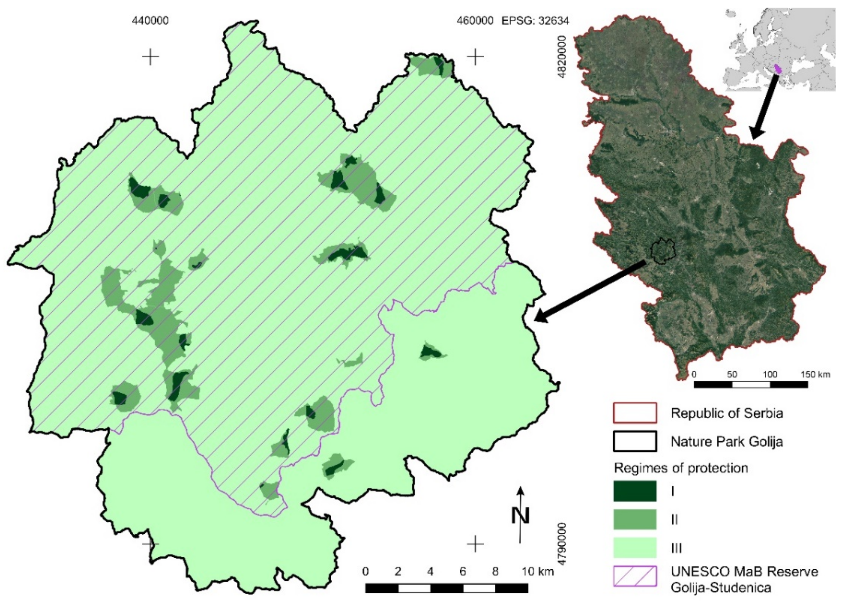
Study Area
2. Materials and Methods
2.1. Forest Fire Susceptibility Index
2.2. Fuzzy AHP
= min V(M ≥ Mi), i = 1,2, …, k
2.3. TOPSIS Method and Classification
2.4. Adopted Fuzzy AHP Methods for the Forest Fire Risk Assessment and Outbreak Detection
3. Results
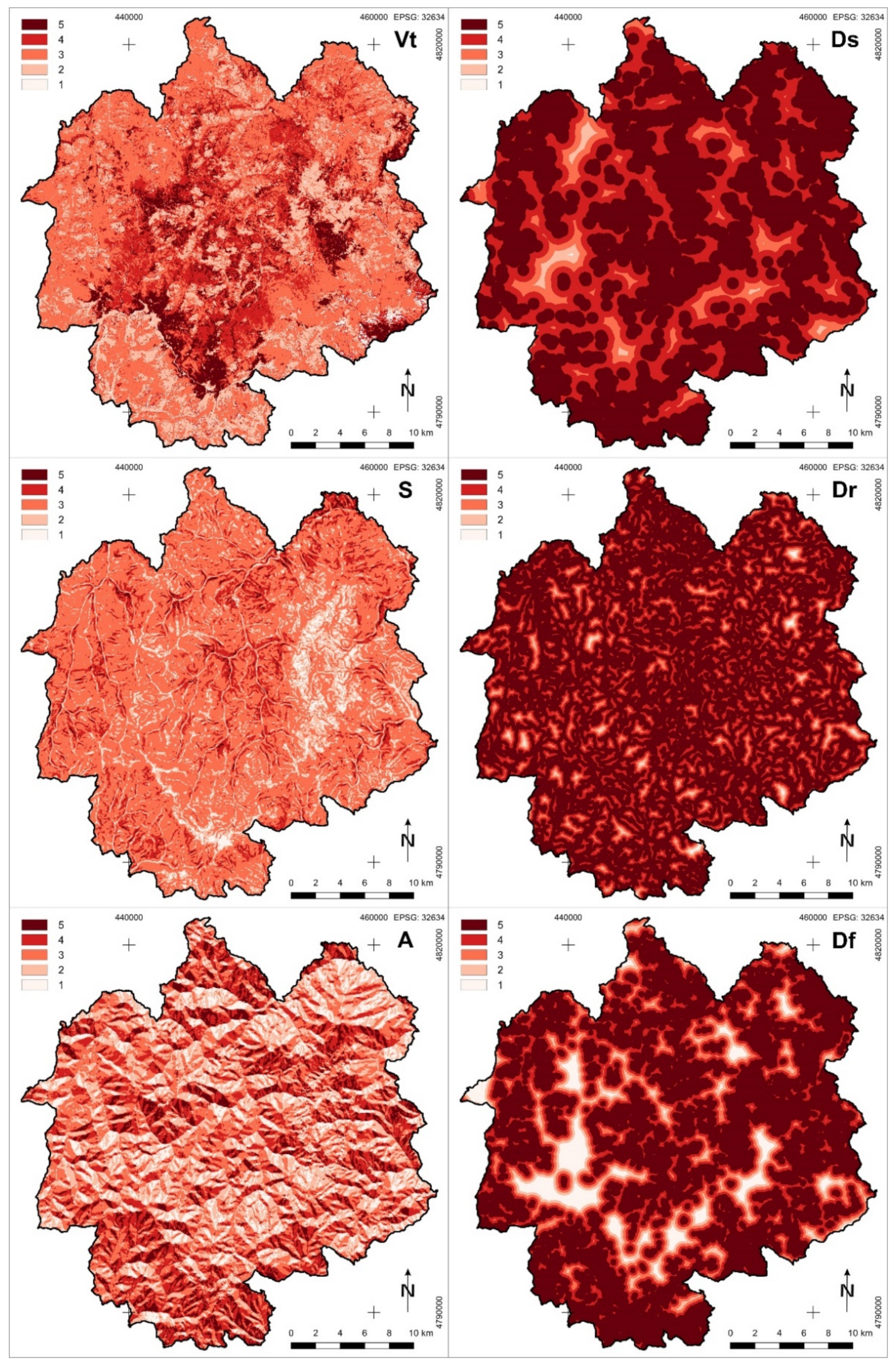
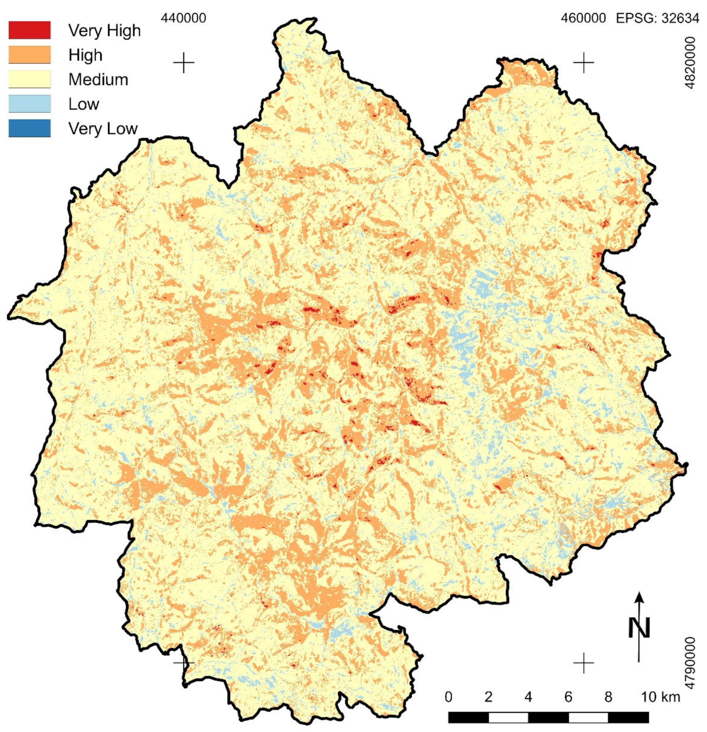
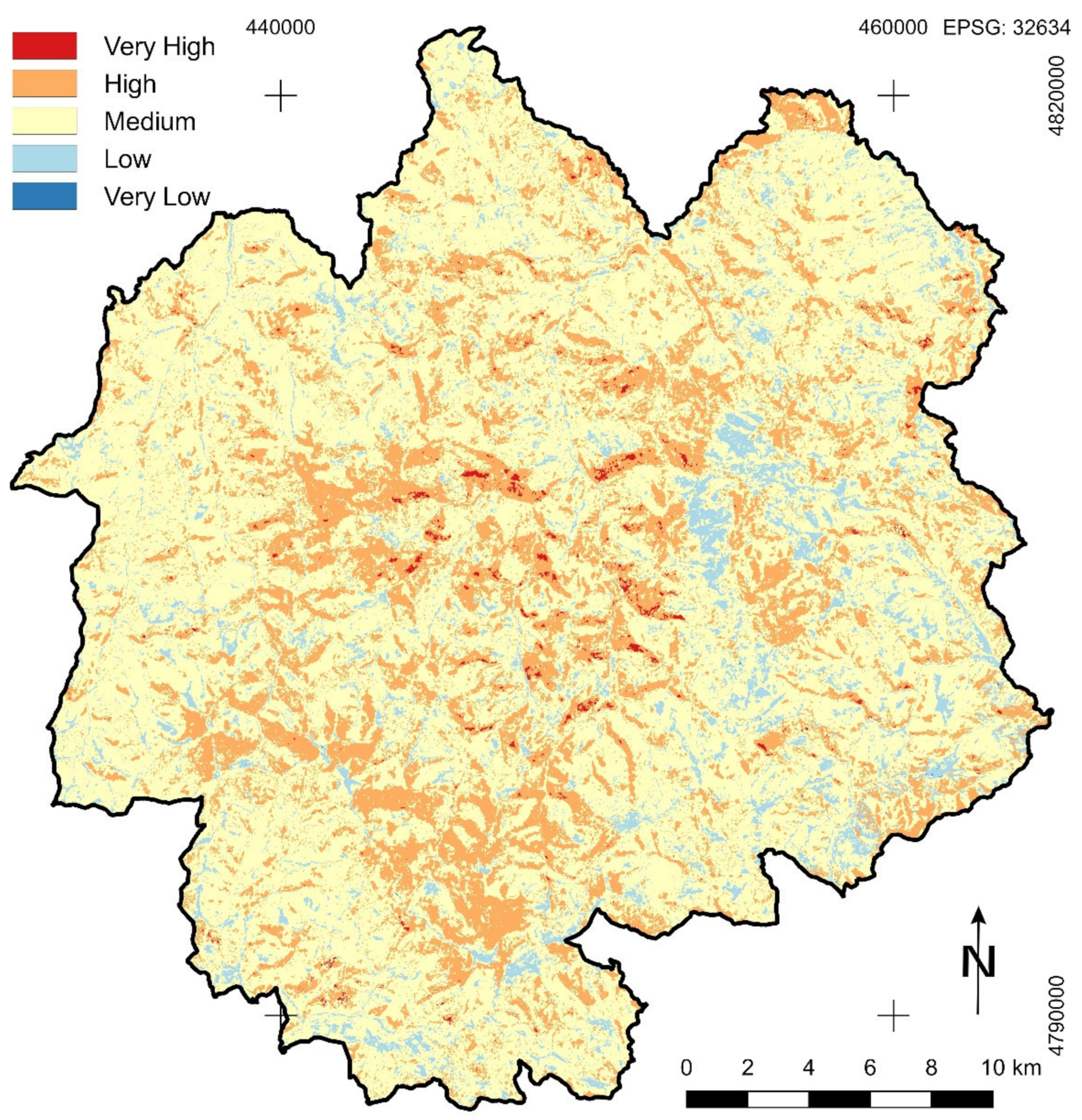
Forest Fire Susceptibility Zonation
4. General Description of Adopted IoT-Based System for the Forest Fire Monitoring
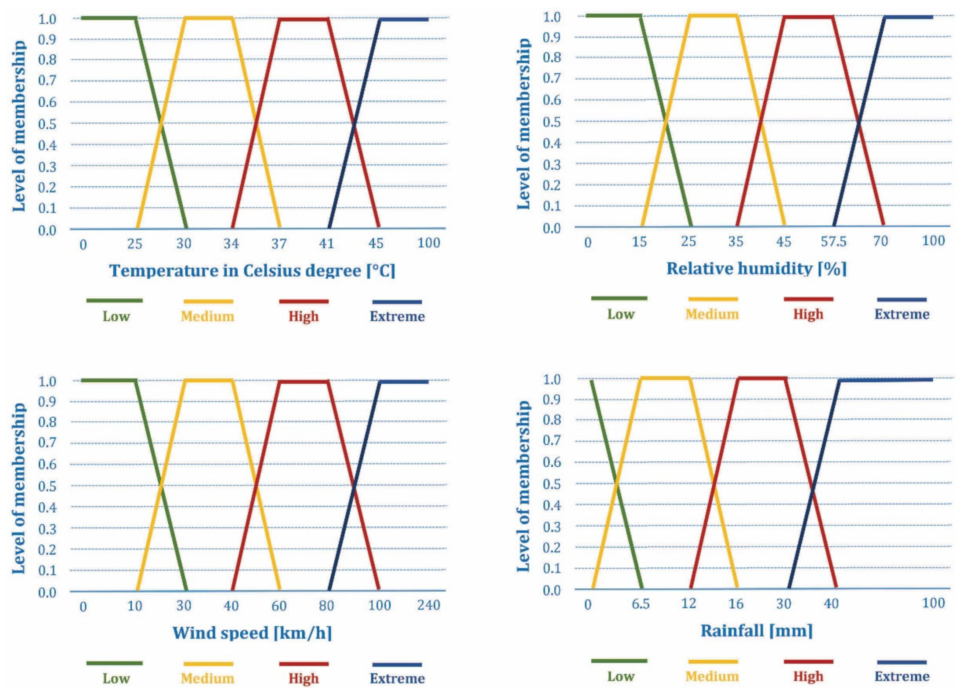
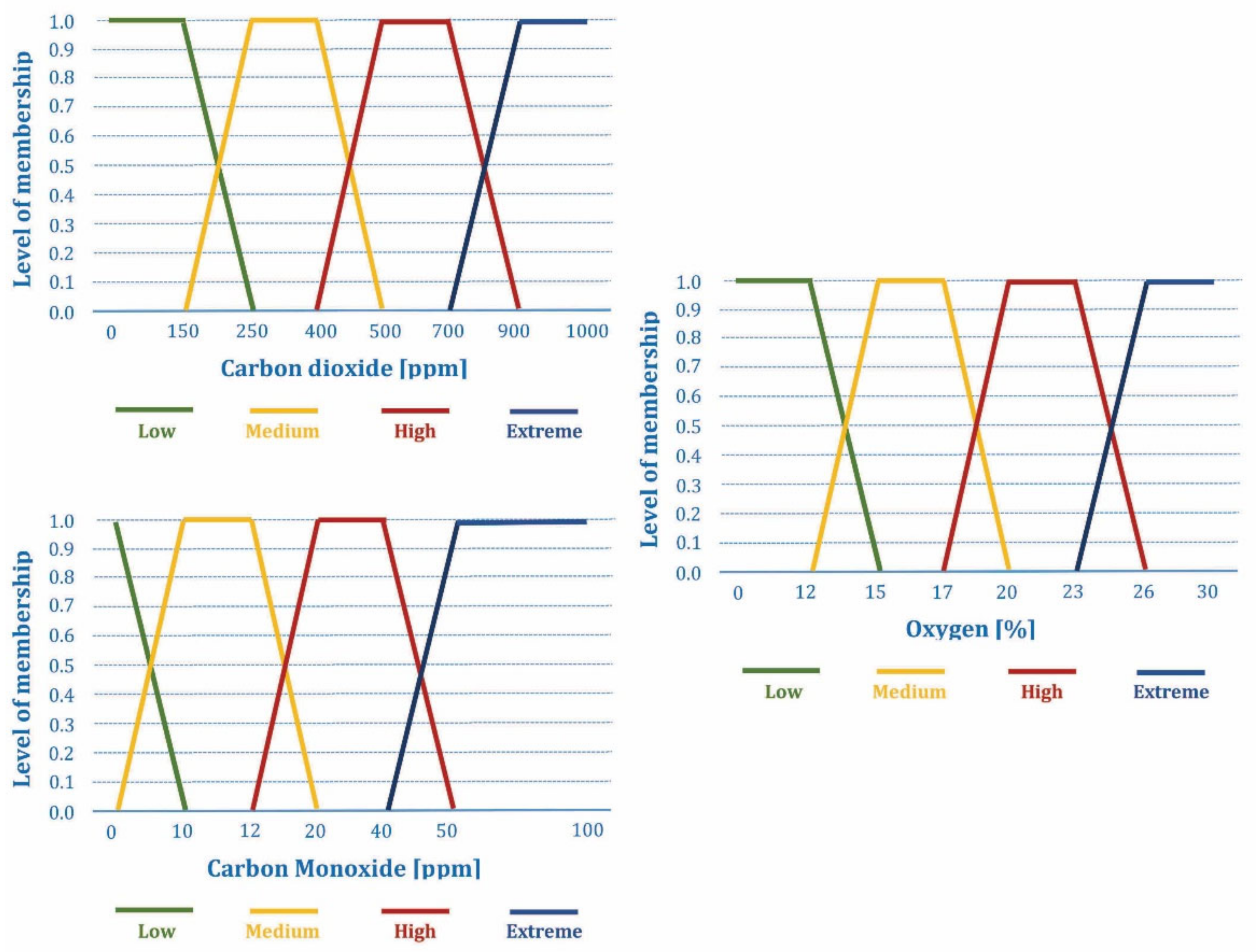
4.1. The Choice of Environmental Parameters for the Forest Fire Risk Prediction and Detection
- Traditional human-based observation systems;
- Satellite-based systems;
- Optical and thermal sensors (cameras)-based systems;
- IoT-based sensor networks and wireless sensor networks (WSN)-based systems;
- Unmanned aerial vehicles (UAV)-based systems.
- The most commonly used set of parameters consists of: temperature (T), relative humidity (H), wind speed (Wspeed), and rainfall (R), [17,18,57,63,64,65,66,67,68,69,70,71,72]. For this set of parameters, the fuzzy AHP method is used [57,63,64,69] for the forest fire risk prediction, sometimes with additional parameters for human behavior and environment [64], while these same parameters were also combined with the concentrations of chemical gases (oxygen, carbon monoxide, and carbon dioxide) in order to detect forest fire outbreaks [57]. Additionally, the same set of parameters is used as an input for artificial neural networks (ANN) [66,68] or linear regression model [70], or to calculate the fire weather index (FWI) [65,67,71,72] by using a pre-defined procedure, for the purpose of forest fire risk prediction.
- The narrowed set of parameters that include temperature and relative humidity is proposed for the forest fire risk prediction in combination with other sensors, such as vision sensors [73,74] with fusion realized using Dempster–Shafer evidential theory, smoke and light intensity sensors [75,76], or light intensity and carbon monoxide sensors [77] by using the fuzzy AHP method. The combined measurements of temperature, relative humidity, and carbon monoxide are employed for forest fire risk prediction with broad set of machine-learning algorithms [78], while the combined measurements of temperature, relative humidity, carbon monoxide, carbon dioxide, and smoke sensors are used as input in ANN [79,80].
- A several simple solutions were proposed in which temperature measurements are combined with the measurements of smoke sensors or combustion sensors (i.e., combined carbon dioxide and nitric oxide measurements) [81,82], or only temperature measurements are used [83], for the forest fire detection by using ANN. Additionally, a combination of temperature and carbon monoxide measurements is used in a simple forest fire detection system [84] with the predefined decision criteria.
- Finally, a very complex solution in which soil parameters (soil temperature, soil moisture), air parameters (air temperature, air moisture, carbon dioxide concentration, wind direction, wind speed, precipitation, negative oxygen ion, PM 2.5), light parameters (global radiation, light intensity, sunshine hours threshold, photo synthetically active radiation), and plant parameters (needle-type stem moisture, non-destructive stem moisture) is used for forest fire prediction [85].
4.2. The Choice of Communication Technology for the IoT-Based Sensor Networks for Forest Fire Prediction and Detection
4.3. Overall System Description
5. Discussion
6. Conclusions
Author Contributions
Funding
Institutional Review Board Statement
Informed Consent Statement
Data Availability Statement
Conflicts of Interest
References
- Gigović, L.; Pourghasemi, H.R.; Drobnjak, S.; Bai, S. Testing a new ensemble model based on SVM and random forest in forest fire susceptibility assessment and its mapping in Serbia’s Tara National Park. Forests 2019, 10, 408. [Google Scholar] [CrossRef] [Green Version]
- Dragićević, S.; Filipović, D.; Kostadinov, S.; Ristić, R.; Novković, I.; Živković, N.; Anđelković, G.; Abolmasov, B.; Šećerov, V.; Đurđić, S. Natural hazard assessment for land-use planning in Serbia. Int. J. Environ. Res. 2011, 5, 371–380. [Google Scholar]
- Lukić, T.; Marić, P.; Hrnjak, I.; Gavrilov, M.B.; Mladjan, D.; Zorn, M.; Komac, B.; Milošević, Z.; Marković, S.B.; Sakulski, D.; et al. Forest fire analysis and classification based on Serbian case study. Acta Geogr. Slov. 2017, 57, 51–63. [Google Scholar] [CrossRef] [Green Version]
- Unkašević, M.; Tošić, I. The maximum temperatures and heat waves in Serbia during the summer of 2007. Clim. Chang. 2011, 108, 207–223. [Google Scholar] [CrossRef]
- Unkašević, M.; Tošić, I. Trends in temperature indices over Serbia: Relationships to large-scale circulation patterns. Int. J. Climatol. 2013, 33, 3152–3161. [Google Scholar] [CrossRef]
- Vuković, A.J.; Vujadinović, M.P.; Rendulić, S.M.; Djurdjević, V.S.; Ruml, M.M.; Babić, V.P.; Popović, D.P. Global warming impact on climate change in Serbia for the period 1961–2100. Therm. Sci. 2018, 22, 2267–2280. [Google Scholar] [CrossRef]
- Institute for Nature Conservation of Serbia, Nature Conservation in Serbia. Available online: https://www.zzps.rs/wp/osnovne-informacije/?lang=en (accessed on 8 October 2020).
- Jaiswal, R.K.; Mukherjee, S.; Raju, K.D.; Saxena, R. Forest fire risk zone mapping from satellite imagery and GIS. Int. J. Appl. Earth. Obs. Geoinf. 2002, 4, 1–10. [Google Scholar] [CrossRef]
- Güngöroğlu, C. Determination of forest fire risk with fuzzy analytic hierarchy process and its mapping with the application of GIS: The case of Turkey/Çakırlar. Hum. Ecol. Risk Assess. 2017, 23, 388–406. [Google Scholar] [CrossRef]
- Eskandari, S.; Miesel, J.R. Comparison of the fuzzy AHP method, the spatial correlation method, and the Dong model to predict the fire high-risk areas in Hyrcanian forests of Iran. Geomat. Nat. Haz. Risk 2017, 8, 933–949. [Google Scholar] [CrossRef] [Green Version]
- Erten, E.; Kurgun, V.; Musaoğlu, N. Forest fire risk zone mapping from satellite imagery and GIS a case study. In Proceedings of the XX Congress of the International Society for Photogrammetry and Remote Sensing, Istanbul, Turkey, 12–23 July 2004; pp. 33–39. [Google Scholar]
- Dong, X.; Li-min, D.; Guo-fan, S.; Lei, T.; Hui, W. Forest fire risk zone mapping from satellite images and GIS for Baihe Forestry Bureau, Jilin, China. J. For. Res. 2005, 16, 169–174. [Google Scholar] [CrossRef]
- Sharma, L.K.; Kanga, S.; Nathawat, M.S.; Sinha, S.; Pandey, C. Fuzzy AHP for forest fire risk modeling. Disaster Prev. Manag. 2012, 21, 160–171. [Google Scholar] [CrossRef]
- Tiwari, A.; Shoab, M.; Dixit, A. GIS-based forest fire susceptibility modeling in Pauri Garhwal, India: A comparative assessment of frequency ratio, analytic hierarchy process and fuzzy modeling techniques. Nat. Hazards 2021, 105, 1189–1230. [Google Scholar] [CrossRef]
- Gheshlaghi, H.A.; Feizizadeh, B.; Blaschke, T. GIS-based forest fire risk mapping using the analytical network process and fuzzy logic. J. Environ. Plan. Manag. 2019, 63, 481–499. [Google Scholar] [CrossRef]
- Kahraman, C.; Cebeci, U.; Ulukan, Z. Multi-criteria supplier selection using fuzzy AHP. Logist. Inf. Manag. 2003, 16, 382–394. [Google Scholar] [CrossRef]
- Chowdhury, E.H.; Hassan, Q.K. Operational perspective of remote sensing-based forest fire danger forecasting systems. ISPRS J. Photogramm. Remote Sens. 2015, 104, 224–236. [Google Scholar] [CrossRef]
- Eskandari, S. A new approach for forest fire risk modeling using fuzzy AHP and GIS in Hyrcanian forests of Iran. Arab J. Geosci. 2017, 10, 190. [Google Scholar] [CrossRef]
- Naderpour, M.; Rizeei, H.M.; Khakzad, N.; Pradhan, B. Forest fire induced Natech risk assessment: A survey of geospatial technologies. Reliab. Eng. Syst. Saf. 2019, 191, 106558. [Google Scholar] [CrossRef]
- Pourghasemi, H.; Beheshtirad, M.; Pradhan, B. A comparative assessment of prediction capabilities of modified analytical hierarchy process (M-AHP) and Mamdani fuzzy logic models using Netcad-GIS for forest fire susceptibility mapping. Geomat. Nat. Hazards Risk 2016, 7, 861–885. [Google Scholar] [CrossRef] [Green Version]
- Grujičić-Tešić, L.; Rabrenović, D.; Kovačević, J.; Gerzina, N.; Đerić, N. Upper cretaceous geosites on Golija Mountain–Objects of Geoheritage. Geol. Croat. 2016, 69, 337–345. [Google Scholar] [CrossRef]
- Milanović, A.; Milovanović, B. A Review of Climate Features of Golija Mountain in the function of space evaluation. Collect. Pap. Fac. Geogr. Univ. Belgrade 2010, 58, 29–46. [Google Scholar]
- Panjković, B.; Pavlović, D.; Perić, R.; Panić, I.; Amidžić, L. Forests with Greek maple (Acer heldreichii Orph. ex Boiss.) on Mt. Golija (Serbia). Biol. Serbica 2014, 36, 18–23. [Google Scholar]
- Mišić, V. The suborder of beech forests in Serbia. In The Vegetation of Serbia II; Sarić, M., Ed.; Serbian Academy of Sciences and Arts: Belgrade, Serbia, 1997. (In Serbian) [Google Scholar]
- Law on Nature Protection, Official Gazette of RS, No. 71/2021-3. (In Serbian). Available online: https://www.pravno-informacioni-sistem.rs/SlGlasnikPortal/eli/rep/sgrs/skupstina/zakon/2009/36/9/reg (accessed on 30 July 2021).
- Decree on Protection Regimes, Official Gazette of RS, No. 31/2012-3. (In Serbian). Available online: https://www.pravno-informacioni-sistem.rs/SlGlasnikPortal/eli/rep/sgrs/vlada/uredba/2012/31/1 (accessed on 15 April 2021).
- Decree on the protection of the Nature Park Golija, Official Gazette of RS, No. 47/2009-3. (In Serbian). Available online: https://www.pravno-informacioni-sistem.rs/SlGlasnikPortal/eli/rep/sgrs/vlada/uredba/2009/47/2 (accessed on 15 April 2021).
- Nature Park Golija Management Plan for the period 2011–2021. (In Serbian). Available online: http://golija-studenica.srbijasume.rs/pdf/PlanUpr20112020.pdf (accessed on 25 April 2021).
- Decree on the determination of the Spatial Plan of the Special Purpose Area of the Nature Park Golija, Official Gazette of RS, No. 16/2009-21. (In Serbian). Available online: https://www.pravno-informacioni-sistem.rs/SlGlasnikPortal/eli/rep/sgrs/vlada/uredba/2009/16/7/reg (accessed on 15 April 2021).
- Živanović, S.; Vukin, M. Effect of global solar radiation threats to forest fire in the area of Nature Park “Golija” Serbia. Šumarstvo 2017, 3–4, 69–84. [Google Scholar]
- Novković, I.; Dragićević, S.; Živković, N.; Tošić, R.; Čvorović, Z. Vulnerability assessment of the Jošanička River Basin to torrential floods and forest fires. In Soil and Water Resources Protection in the Changing Environment; Zlatić, M., Kostadinov, S., Eds.; Catena Soil Sciences, Schweizerbart Science Publishers: Stuttgart, Germany, 2018; Volume 45, pp. 65–78. [Google Scholar]
- Bennett, M.; Fitzgerald, S.; Parker, B.; Main, M.; Perleberg, A.; Schnepf, C.; Mahoney, R. Reducing Fire Risk on Your Forest Property; Pacific Northwest Extension Publications, Oregon State University: Corvallis, Oregon, USA; Washington State University: Pullman, WA, USA; University of Idaho: Moscow, ID, USA, 2010; p. 40. [Google Scholar]
- Bonora, L.; Conese, C.; Marchi, E.; Tesi, E.; Montorseli, N.B. Wildfire occurrence: Integrated model for risk analysis and operative suppression aspects management. Am. J Plant Sci. 2013, 4, 705–713. [Google Scholar] [CrossRef] [Green Version]
- Copernicus Land Monitoring Service, Imagery and Reference Data, EU-DEM v1.1. Available online: https://land.copernicus.eu/imagery-in-situ/eu-dem/eu-dem-v1.1 (accessed on 5 July 2020).
- Liu, Y.; Gong, W.; Hu, X.; Gong, J. Forest type identification with random forest using Sentinel-1A, Sentinel-2A, Multi-Temporal Landsat-8 and DEM Data. Remote Sens. 2018, 10, 946. [Google Scholar] [CrossRef] [Green Version]
- Liaw, A.; Wiener, M. Classification and regression by Random Forest. R News 2002, 2, 18–22. [Google Scholar]
- Copernicus Open Access Hub. Available online: https://scihub.copernicus.eu/ (accessed on 15 July 2020).
- Zadeh, L.A. Fuzzy sets. Inf. Control. 1965, 8, 338–353. [Google Scholar] [CrossRef] [Green Version]
- Vadrevu, K.P.; Eaturu, A.; Badarinath, K.V.S. Fire risk evaluation using multicriteria analysis—A case study. Environ. Monit. Assess. 2009, 166, 223–239. [Google Scholar] [CrossRef] [PubMed]
- Božanić, D.; Karović, S.; Pamučar, D. Fazifikacija Saaty-jeve skale primenom trouglastog fuzzy broja sa promenljivim inter-valom poverenja. In Proceedings of the XLII Simpozijum o Operacionim Istraživanjima (SYM-OP-IS 2015), Srebrno Jezero, Serbia, 15–18 September 2015; pp. 420–424. [Google Scholar]
- Saaty, T.L. A scaling method for priorities in hierarchical structures. J. Math. Psychol. 1977, 15, 59–62. [Google Scholar] [CrossRef]
- Yeap, J.A.L.; Ignatius, J.; Ramayah, T. Determining consumers most preferred eWOM platform for movie reviews: A fuzzy analytic hierarchy process approach. Comput. Hum. Behav. 2014, 31, 250–258. [Google Scholar] [CrossRef]
- John, A.; Paraskevadakis, D.; Bury, A.; Yang, Z.; Riahi, R. An integrated fuzzy risk assessment for seaport operations. Saf. Sci. 2014, 68, 180–194. [Google Scholar] [CrossRef] [Green Version]
- Vahidnia, M.H.; Alesheikh, A.; Alimohammadi, A.; Bassiri, A. Fuzzy Analytical Hierarchy Process in GIS Application. In Proceedings of the XXI Congress of the International Society for Photogrammetry and Remote Sensing, Beijing, China, 3–11 July 2008; pp. 593–596. [Google Scholar]
- Onay, A.; Karamaşa, Ç.; Saraç, B. Application of fuzzy AHP in selection of accounting elective courses in undergraduate and graduate level. J. Account. Financ. Audit. Stud. 2016, 2, 20–42. [Google Scholar]
- Wijitkosum, S.; Sriburi, T. Fuzzy AHP Integrated with GIS analysis for drought risk assessment: A case study from upper Phetchaburi River Basin, Thailand. Water 2019, 11, 939. [Google Scholar] [CrossRef] [Green Version]
- Feizizadeh, B.; Roodposhti, M.S.; Jankowski, P.; Blaschke, T. A GIS-based extended fuzzy multi-criteria evaluation for landslide susceptibility mapping. Comput. Geosci. 2014, 73, 208–221. [Google Scholar] [CrossRef] [PubMed] [Green Version]
- Celik, M.; Deha Er, I.; Ozok, F.A. Application of fuzzy extended AHP methodology on shipping registry selection: The case of Turkish maritime industry. Expert Syst. Appl. 2009, 36, 190–198. [Google Scholar] [CrossRef]
- Radhakrishnan, R.; Kalaichelvi, A. Selection of the best school for the children—A decision making model using extent analysis method of fuzzy analytic hierarchy process. Int. J. Innov. Res. Sci. Eng. Technol. 2014, 3, 12334–12344. [Google Scholar]
- Aggarwal, R.; Singh, S. AHP and extent fuzzy AHP approach for prioritization of performance measurement attributes. Int. J. Ind. Manuf. Eng. 2013, 7, 6–11. [Google Scholar]
- Novoselac, V.; Pavić, Z. Notes on TOPSIS Method. Int. J. Res. Eng. Sci. (IJRES) 2013, 1, 5–12. [Google Scholar]
- Dammak, F.; Baccour, L.; Alimi, A. Crisp multi-criteria decision making methods: State of the art. Int. J. Comput. Sci. Inf. Secur. 2016, 14, 252–264. [Google Scholar]
- Tzeng, G.H.; Huang, J.J. Multiple Attribute Decision Making: Methods and Applications; CRC Press, Taylor & Francis Group: Boca Raton, NJ, USA, 2011; pp. 1–350. [Google Scholar]
- Jozaghi, A.; Alizadeh, B.; Hatami, M.; Flood, I.; Khorrami, M.; Khodaei, N.; Tousi, E.G. A comparative study of the AHP and TOPSIS techniques for dam site selection using GIS: A case study of Sistan and Baluchestan Province, Iran. Geosciences 2018, 8, 494. [Google Scholar] [CrossRef] [Green Version]
- Soufi, M.D.; Ghobadian, B.; Najafi, G.; Sabzimaleki, M.R.; Yusuf, T. TOPSIS Multi-criteria decision modeling approach for biolubricant selection for two-stroke petrol engines. Energies 2015, 8, 13960–13970. [Google Scholar] [CrossRef] [Green Version]
- Yue, Z. A method for group decision-making based on determining weights of decision makers using TOPSIS. Appl. Math. Model. 2011, 35, 1926–1936. [Google Scholar] [CrossRef] [Green Version]
- Toledo-Castro, J.; Caballero-Gil, P.; Rodríguez-Pérez, N.; Santos-González, I.; Hernández-Goya, C.; Aguasca-Colomo, R. Forest Fire prevention, detection, and fighting based on fuzzy logic and wireless sensor networks. Complexity 2018, 2018, 1–17. [Google Scholar] [CrossRef]
- Mamdani, E.H. Application of fuzzy logic to approximate reasoning using linguistic synthesis. IEEE Trans. Comput. 1977, 26, 1182–1191. [Google Scholar] [CrossRef]
- Runkler, T.A. Selection of appropriate defuzzification methods using application specific properties. IEEE Trans. Fuzzy Syst. 1997, 5, 72–79. [Google Scholar] [CrossRef]
- Sendra, S.; García, L.; Lloret, J.; Bosch, I.; Vega-Rodríguez, R. LoRaWAN Network for fire monitoring in rural environments. Electronics 2020, 9, 531. [Google Scholar] [CrossRef] [Green Version]
- Aspragathos, N.; Dogkas, E.; Konstantinidis, P.; Koutmos, P.; Lamprinou, N.; Moulianitis, V.; Paterakis, G.; Psarakis, E.Z.; Sartinas, E.; Souflas, K.; et al. From pillars to AI technology-based forest fire protection systems. In Intelligent System and Computing; Yang, Y., Ed.; IntechOpen: London, UK, 2020. [Google Scholar]
- Alkhatib, A.A.A. A review on forest fire detection techniques. Int. J. Distrib. Sens. Netw. 2014, 2014, 1–12. [Google Scholar] [CrossRef] [Green Version]
- Gao, D.; Lin, H.; Jiang, A. A forest fire prediction system based on rechargeable wireless sensor networks. In Proceedings of the 4th IEEE International Conference on Network Infrastructure and Digital Content, Beijing, China, 19–21 September 2014; pp. 405–408. [Google Scholar]
- Lin, H.; Liu, X.; Wang, X.; Liu, Y.F. A fuzzy inference and big data analysis algorithm for the prediction of forest fire based on rechargeable wireless sensor networks. Sustain. Comput. Inform. Syst. 2017, 18, 101–111. [Google Scholar] [CrossRef]
- Cortez, P.; Morais, A.A. Data mining approach to predict forest fires using meteorological data. In New Trends in Artificial Intelligence; Neves, J., Santos, M.F., Machado, J., Eds.; APPIA: Guimaraes, Portugal, 2007; pp. 512–523. [Google Scholar]
- Zhu, H.; Gao, D.; Zhang, S. A Perceptron Algorithm for Forest Fire Prediction Based on Wireless Sensor Networks. J. Internet Things 2019, 1, 25–31. [Google Scholar] [CrossRef]
- Benzekri, W.; Moussati, A.E.; Moussaoui, O.; Berrajaa, M. Early forest fire detection with low power wireless sensors networks. In Advances in Smart Technologies Applications and Case Studies. Lecture Notes in Electrical Engineering; El Moussati, A., Kpalma, K., Belkasmi, M., Saber, M., Guégan, S., Eds.; Springer: Berlin/Heidelberg, Germany, 2020; Volume 684. [Google Scholar]
- Elmas, C.; Sönmez, Y. A data fusion framework with novel hybrid algorithm for multi-agent decision support system for forest fire. Expert Syst. Appl. 2011, 38, 9225–9236. [Google Scholar] [CrossRef]
- Neshat, M.; Tabatabi, M.; Zahmati, E.; Shirdel, M. A hybrid fuzzy knowledge-based system for forest fire risk forecasting. Int. J. Reason Based Intell. Syst. 2016, 8, 132–153. [Google Scholar] [CrossRef]
- Wang, L.; Zhao, Q.; Wen, Z.; Qu, J. RAFFIA: Short-term forest fire danger rating prediction via multiclass logistic regression. Sustainability 2018, 10, 4620. [Google Scholar] [CrossRef] [Green Version]
- Kucuk, G.; Kosucu, B.; Yavas, A.; Baydere, S. FireSense: Forest fire prediction and detection system using wireless sensor networks. In Proceedings of the 4th IEEE/ACM International Conference Distributed Computing in Sensor Systems, Santorini Island, Greece, 11–14 June 2008; pp. 1–4. [Google Scholar]
- Zhang, K.; Molina-Pico, A.; Cuesta-Frau, D.; Alvaro, A.; Javier, A.; Alba, R. Forest monitoring and wildland early fire detection by a hierarchical wireless sensor network. J. Sens. 2016, 16, 832584. [Google Scholar]
- Sekkas, O.; Hadjieftymiades, S.; Zervas, E. A multi-level data fusion approach for early fire detection. In Proceedings of the IEEE International Conference on Intelligent Networking and Collaborative Systems 2010, Thessaloniki, Greece, 24–26 November 2010; pp. 479–483. [Google Scholar]
- Zervas, E.; Mpimpoudis, A.; Anagnostopoulos, C.; Sekkas, O.; Hadjiefthymiades, S. Multisensor data fusion for fire detection. Inf. Fusion 2011, 12, 150–159. [Google Scholar] [CrossRef]
- Garcia-Jimenez, S.; Jurio, A.; Pagola, M.; de Miguel, L.; Barrenechea, E.; Bustince, H. Forest fire detection: A fuzzy system approach based on overlap indices. Appl. Soft Comput. 2017, 52, 834–842. [Google Scholar] [CrossRef]
- Bolourchi, P.; Uysal, S. Forest fire detection in wireless sensor network using fuzzy logic. In Proceedings of the 5th International Conference on Computational Intelligence, Communication Systems and Networks, Madrid, Spain, 5–7 June 2013; pp. 83–87. [Google Scholar]
- Dutta, M.; Bhowmik, S.; Giri, C. Fuzzy logic based implementation for forest fire detection using wireless sensor network. In Advanced Computing, Networking and Informatics, Volume 1. Smart Innovation, Systems and Technologies; Kumar, K.M., Mohapatra, D., Konar, A., Chakraborty, A., Eds.; Springer: Berlin/Heidelberg, Germany, 2014; Volume 27. [Google Scholar]
- Sharma, R.; Rani, S.; Memon, I. A smart approach for fire prediction under uncertain conditions using machine learning. Multimed Tools Appl. 2020, 79, 28155–28168. [Google Scholar] [CrossRef]
- Yan, X.; Cheng, H.; Zhao, Y.; Yu, W.; Huang, H.; Zheng, X. Real-time identification of smoldering and flaming combustion phases in forest using a wireless sensor network-based multi-sensor system and artificial neural network. Sensors 2016, 16, 1228. [Google Scholar] [CrossRef]
- Chauhan, A.; Semwal, S.; Chawan, R. Artificial neural network-based forest fire detection system using wireless sensor network. In Proceedings of the 2013 Annual IEEE India Conference (INDICON), Mumbai, India, 13–15 December 2013; pp. 1–6. [Google Scholar]
- Saldamli, G.; Deshpande, S.; Jawalekar, K.; Gholap, P.; Tawalbeh, L.; Ertaul, L. Wildfire detection using wireless mesh network. In Proceedings of the 2019 Fourth International Conference on Fog and MobileEdge Computing (FMEC), Rome, Italy, 10–13 June 2019; pp. 229–234. [Google Scholar]
- Jayaram, K.; Janani, K.; Jeyaguru, R.; Kumaresh, R.; Muralidharan, N. Forest fire alerting system with GPS Co-ordinates using IoT. In Proceedings of the 2019 5th International Conference on Advanced Computing & Communication Systems (ICACCS), Coimbatore, India, 15–16 March 2019; pp. 488–491. [Google Scholar]
- Soliman, H.; Sudan, K.; Mishra, A. A smart forest-fire early detection sensory system: Another approach of utilizing wireless sensor and neural networks. In Proceedings of the 9th Annual IEEE Conference on Sensors, Waikoloa, HI, USA, 1–4 November 2010; pp. 1900–1904. [Google Scholar]
- Yahya, Z.D.; Koesuma, S. Development of forest fire early warning system based on the wireless sensor network in Lawu Mountain. J. Phys. Conf. Ser. 2019, 1153, 012025. [Google Scholar] [CrossRef]
- Zheng, Y.; Zhao, Y.; Liu, W.; Liu, S.; Yao, R. An intelligent wireless system for field ecology monitoring and forest fire warning. Sensors 2018, 18, 4457. [Google Scholar] [CrossRef] [PubMed] [Green Version]
- Akyildiz, I.; Su, W.; Sankarasubramaniam, Y.; Cayirci, E. Wireless sensor networks: A survey. Comput. Netw. J. 2002, 3, 393–422. [Google Scholar] [CrossRef] [Green Version]
- Yu, L.; Wang, N.; Meng, X. Real-time forest fire detection with wireless sensor networks. In Proceedings of the International Conference on Wireless Communications, Networking and Mobile Computing 2005, Wuhan, China, 26 September 2005; pp. 1214–1217. [Google Scholar]
- Cuomo, V.; Lasaponara, R.; Tramutoli, V. Evaluation of a new satellite-based method for forest fire detection. Int. J. Remote Sens. 2001, 22, 1799–1826. [Google Scholar] [CrossRef]
- Lee, J.-S.; Su, Y.; Shen, C.-C. A Comparative study of wireless protocols: Bluetooth, UWB, ZigBee, and Wi-Fi. In Proceedings of the 33rd Annual Conference of the IEEE Industrial Electronics Society (IECON), Taipei, Taiwan, 5–8 November 2007; pp. 46–51. [Google Scholar]
- Ratasuk, R.; Vejlgaard, B.; Mangalvedhe, N.; Ghosh, A. NB-IoT system for M2M communication. In Proceedings of the IEEE Wireless Communications and Networking Conference, Doha, Qatar, 3–6 April 2016; pp. 428–432. [Google Scholar]
- Lavric, A.; Petrariu, A.I. LoRaWAN communication protocol: The new era of IoT. In Proceedings of the International Conference on Development and Application Systems (DAS), Suceava, Romania, 24–26 May 2018; pp. 74–77. [Google Scholar]
- Brito, T.; Pereira, A.I.; Lima, J.; Valente, A. Wireless sensor network for ignitions detection: An IoT approach. Electronics 2020, 9, 893. [Google Scholar] [CrossRef]
- Foubert, B.; Mitton, N. Long-range wireless radio technologies: A survey. Future Internet 2020, 12, 13. [Google Scholar] [CrossRef] [Green Version]
- Haxhibeqiri, J.; de Poorter, E.; Moerman, I.; Hoebeke, J. A survey of LoRaWAN for IoT: From technology to application. Sensors 2018, 18, 3995. [Google Scholar] [CrossRef] [PubMed] [Green Version]
- Hristov, G.; Raychev, J.; Kinaneva, D.; Zahariev, P. Emerging methods for early detection of forest fires using unmanned aerial vehicles and LoRaWAN Sensor Networks. In Proceedings of the 28th EAEEIE Annual Conference, Reykjavik, Iceland, 26–28 September 2018; pp. 1–9. [Google Scholar]
- Vega-Rodríguez, R.; Sendra, S.; Lloret, J.; Romero-Díaz, P.; Garcia-Navas, J.L. Low Cost LoRa based network for forest fire detection. In Proceedings of the 6th International Conference on Internet of Things: Systems, Management and Security (IOTSMS), Granada, Spain, 22–25 October 2019; pp. 177–184. [Google Scholar]
- Lecina-Diaz, J.; Alvarez, A.; Retana, J. Extreme fire severity patterns in topographic, convective and wind-driven historical wildfires of Mediterranean pine forests. PLoS ONE 2014, 9, e85127. [Google Scholar] [CrossRef] [Green Version]
- Zanakis, S.H.; Solomon, A.; Wishart, N.; Dublish, S. Multiattribute decision making: A simulation comparison of selectmethods. Eur. J. Oper. Res. 1998, 107, 507–529. [Google Scholar] [CrossRef]
- Canada Forest Service Home Page. Available online: http://cfs.nrcan.gc.ca/ (accessed on 10 November 2020).
- ISDR. Living with Risk–A Global Review of Disaster Reduction Initiatives; United Nations Inter-Agency Secretariate of the International Strategy for Disaster Reduction: Geneva, Switzerland, 2004. [Google Scholar]
- Dragićević, S.; Mészáros, M.; Djurdjić, S.; Pavić, D.; Novković, I.; Tošić, R. Vulnerability of national parks to natural hazards in the Serbian Danube region. Pol. J. Environ. Stud. 2013, 22, 75–82. [Google Scholar]
- Stolton, S.; Dudley, N.; Randall, J. Natural Security: Protected Areas and Hazard Mitigation, Arguments for Protection; World Wildlife Fund for Nature: Rexburg, ID, USA, 2008; p. 128. [Google Scholar]
- Gheshlaghi, H.A.; Feizizadeh, B.; Blaschke, T.; Lakes, T.; Tajbar, S. Forest fire susceptibility modeling using hybrid approaches. Trans. GIS 2021, 25, 311–333. [Google Scholar] [CrossRef]


| Class Value | Vt | S [°] | A [°] | Ds [m] | Dr [m] | Df [m] |
|---|---|---|---|---|---|---|
| 5 | Coniferous forest | >35 | S (157.5–202.5) | <500 | <150 | <200 |
| 4 | Mixed forest; shrub | 25–35 | SE (112.5–157.5); SW (202.5–247.5) | 500–1000 | 150–300 | 200–400 |
| 3 | Broad-leaved forest | 10–25 | E (67.5–112.5); W (247.5–292.5) | 1000–1500 | 300–450 | 400–600 |
| 2 | Agricultural areas; grassland | 5–10 | NE (22.5–67.5); NW (292.5–337.5) | 1500–2000 | 450–600 | 600–800 |
| 1 | Artificial areas; barren rocks | <5 | N (0–22.5, 337.5–360) | >2000 | >600 | >800 |
| Performance Index Value | Forest Fire Susceptibility Zone |
|---|---|
| 0.0–0.2 | Very high |
| 0.2–0.4 | High |
| 0.4–0.6 | Medium |
| 0.6–0.8 | Low |
| 0.8–1.0 | Very low |
| Variable | Fuzzy Set | Fuzzy Domain |
|---|---|---|
| Temperature (T) | FST = {low, medium, high, extreme} | [0, 100] °C |
| Humidity (H) | FSH = {low, medium, high, extreme} | [0, 100] % |
| Wind speed (Wspeed) | FSW = {low, medium, high, extreme} | [0, 240] km/h |
| Rainfall (R) | FSR = {low, medium, high, extreme} | [0, 100] mm/m3 |
| Oxygen (O2) | FSO2 = {low, medium, high, extreme} | [0, 30] % |
| Carbon dioxide (CO2) | FSCO2 = {low, medium, high, extreme} | [0, 1000] ppm |
| Carbon monoxide (CO2) | FSCO = {low, medium, high, extreme} | [0, 100] ppm |
| Forest Fire Risk | Fire Outbreak Occurrence | Measurement Frequency | Average Calculation |
|---|---|---|---|
| Non-existent | Non-existent | 5 minutes | Last 20 measurements |
| Low | / | 2 minutes | Last 15 measurements |
| High | / | Continuous | Last 10 measurements |
| Extreme | 5–10 | Continuous | Last 5 measurements |
| Class Value | Vt [%] | S [%] | A [%] | Ds [%] | Dr [%] | Df [%] |
|---|---|---|---|---|---|---|
| 5 | 9.44 | 1.32 | 10.31 | 66.98 | 71.50 | 62.74 |
| 4 | 22.25 | 13.21 | 23.94 | 26.47 | 22.69 | 18.54 |
| 3 | 48.47 | 66.79 | 28.23 | 5.68 | 4.86 | 9.69 |
| 2 | 17.91 | 13.87 | 25.91 | 0.86 | 0.82 | 4.93 |
| 1 | 1.93 | 4.81 | 11.61 | 0.01 | 0.12 | 4.11 |
| Vt | A | S | Dr | Ds | Df | |
|---|---|---|---|---|---|---|
| Vt | 1, 1, 1 | 1, 2, 3 | 1.5, 2.5, 3.5 | 2, 3, 4 | 2, 3, 4 | 2, 3, 4 |
| A | 0.33, 0.5, 1 | 1, 1, 1 | 1, 2, 3 | 1, 2, 3 | 1, 2, 3 | 1, 2, 3 |
| S | 0.29, 0.4, 0.67 | 0.33, 0.5, 1 | 1, 1, 1 | 1, 2, 3 | 1, 2, 3 | 1, 2, 3 |
| Dr | 0.25, 0.33, 0.5 | 0.33, 0.5, 1 | 0.33, 0.5, 1 | 1, 1, 1 | 1, 1, 1 | 1, 2, 3 |
| Ds | 0.25, 0.33, 0.5 | 0.33, 0.5, 1 | 0.33, 0.5, 1 | 1, 1, 1 | 1, 1, 1 | 1, 2, 3 |
| Df | 0.25, 0.33, 0.5 | 0.33, 0.5, 1 | 0.33, 0.5, 1 | 0.33, 0.5, 1 | 0.33, 0.5, 1 | 1, 1, 1 |
| Factors | wj |
|---|---|
| Vt | 0.311 |
| A | 0.233 |
| S | 0.196 |
| Dr | 0.108 |
| Ds | 0.108 |
| Df | 0.044 |
| Susceptibility Class | RC [%] | Fuzzy AHP [%] |
|---|---|---|
| Very high | 0.48 | 0.49 |
| High | 24.23 | 23.19 |
| Medium | 70.51 | 69.05 |
| Low | 4.78 | 7.26 |
| Very low | 0.0002 | 0.01 |
| Susceptibility Class | RC [%] | Fuzzy AHP[%] | ||||
|---|---|---|---|---|---|---|
| I | II | III | I | II | III | |
| Very high | 0.11 | 0.70 | 0.47 | 0.11 | 0.69 | 0.48 |
| High | 32.44 | 34.17 | 23.49 | 32.04 | 34.11 | 22.38 |
| Medium | 66.22 | 63.01 | 71.05 | 65.59 | 61.80 | 69.56 |
| Low | 1.23 | 2.12 | 4.99 | 2.27 | 3.39 | 7.57 |
| Very low | 0.00 | 0.00 | 0.0002 | 0.00 | 0.01 | 0.01 |
| Susceptibility Class | RC [%] | Fuzzy AHP [%] |
|---|---|---|
| Very high | 0.57 | 0.59 |
| High | 26.28 | 25.15 |
| Medium | 69.17 | 68.04 |
| Low | 3.97 | 6.21 |
| Very low | 0.00 | 0.003 |
Publisher’s Note: MDPI stays neutral with regard to jurisdictional claims in published maps and institutional affiliations. |
© 2021 by the authors. Licensee MDPI, Basel, Switzerland. This article is an open access article distributed under the terms and conditions of the Creative Commons Attribution (CC BY) license (https://creativecommons.org/licenses/by/4.0/).
Share and Cite
Novkovic, I.; Markovic, G.B.; Lukic, D.; Dragicevic, S.; Milosevic, M.; Djurdjic, S.; Samardzic, I.; Lezaic, T.; Tadic, M. GIS-Based Forest Fire Susceptibility Zonation with IoT Sensor Network Support, Case Study—Nature Park Golija, Serbia. Sensors 2021, 21, 6520. https://doi.org/10.3390/s21196520
Novkovic I, Markovic GB, Lukic D, Dragicevic S, Milosevic M, Djurdjic S, Samardzic I, Lezaic T, Tadic M. GIS-Based Forest Fire Susceptibility Zonation with IoT Sensor Network Support, Case Study—Nature Park Golija, Serbia. Sensors. 2021; 21(19):6520. https://doi.org/10.3390/s21196520
Chicago/Turabian StyleNovkovic, Ivan, Goran B. Markovic, Djordje Lukic, Slavoljub Dragicevic, Marko Milosevic, Snezana Djurdjic, Ivan Samardzic, Tijana Lezaic, and Marija Tadic. 2021. "GIS-Based Forest Fire Susceptibility Zonation with IoT Sensor Network Support, Case Study—Nature Park Golija, Serbia" Sensors 21, no. 19: 6520. https://doi.org/10.3390/s21196520
APA StyleNovkovic, I., Markovic, G. B., Lukic, D., Dragicevic, S., Milosevic, M., Djurdjic, S., Samardzic, I., Lezaic, T., & Tadic, M. (2021). GIS-Based Forest Fire Susceptibility Zonation with IoT Sensor Network Support, Case Study—Nature Park Golija, Serbia. Sensors, 21(19), 6520. https://doi.org/10.3390/s21196520