


Soil Erosion Modelling and Accumulation Using RUSLE and Remote Sensing Techniques: Case Study Wadi Baysh, Kingdom of Saudi Arabia

 ,
,  ,
,  ,
,  ,
,  and
and 
Abstract
:1. Introduction
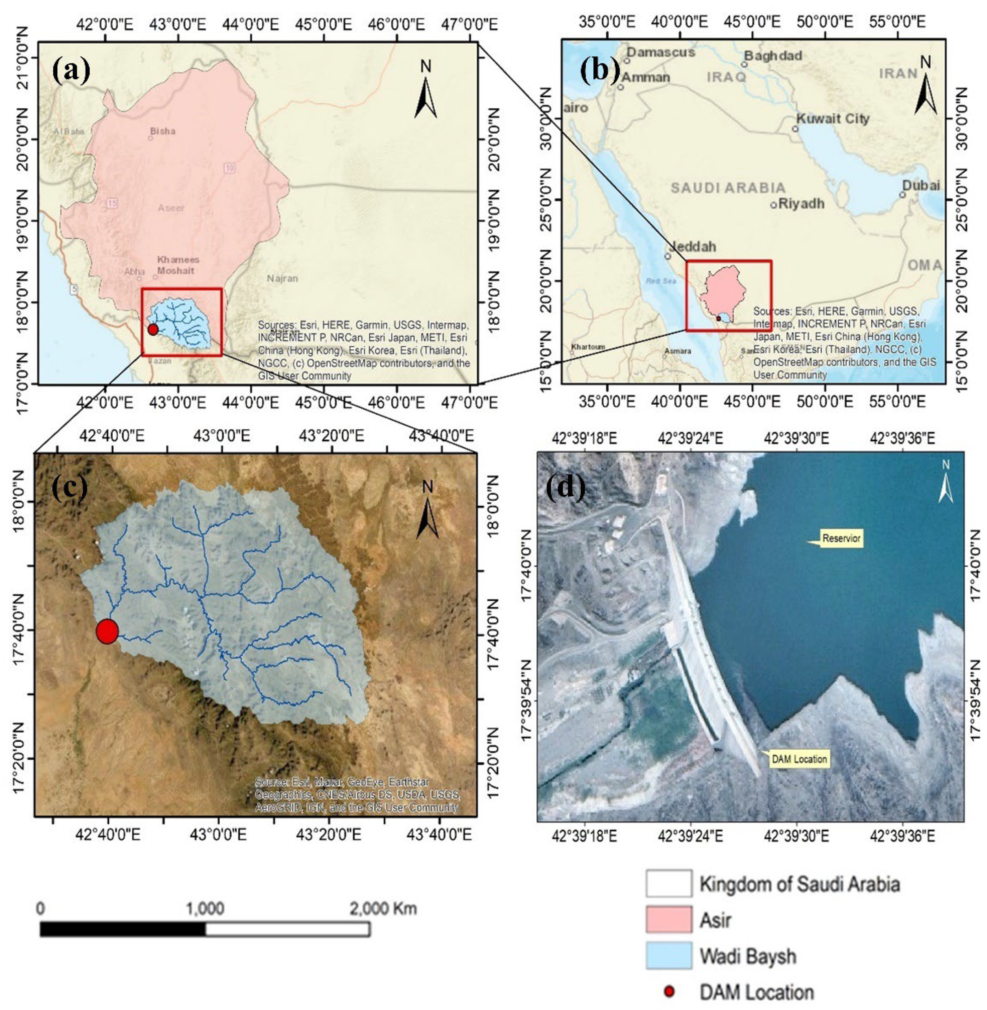
2. Study Area
3. Material and Methods
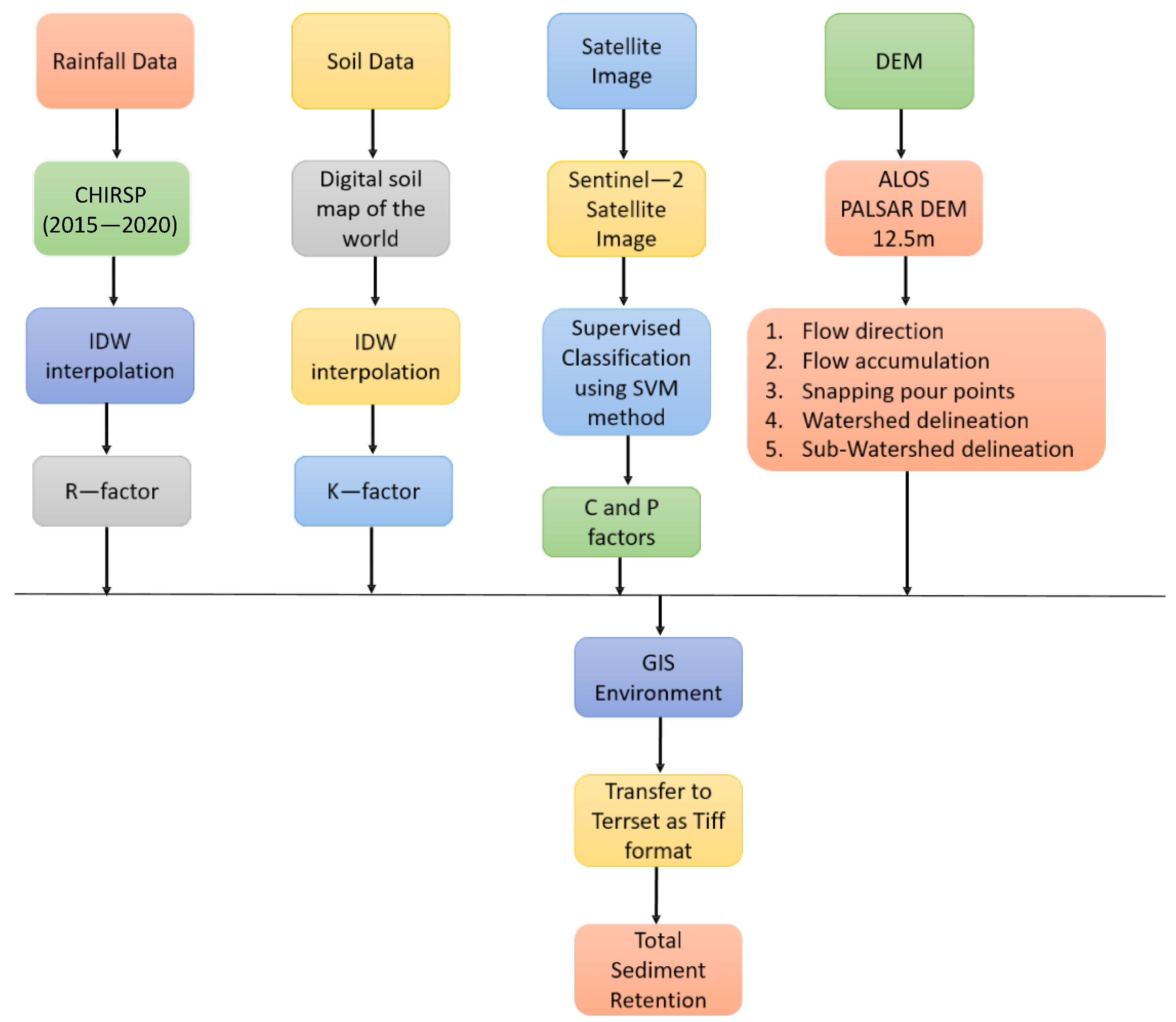
3.1. Data Collection
3.2. TerrSet
3.3. RUSLE Model
3.3.1. R Factor
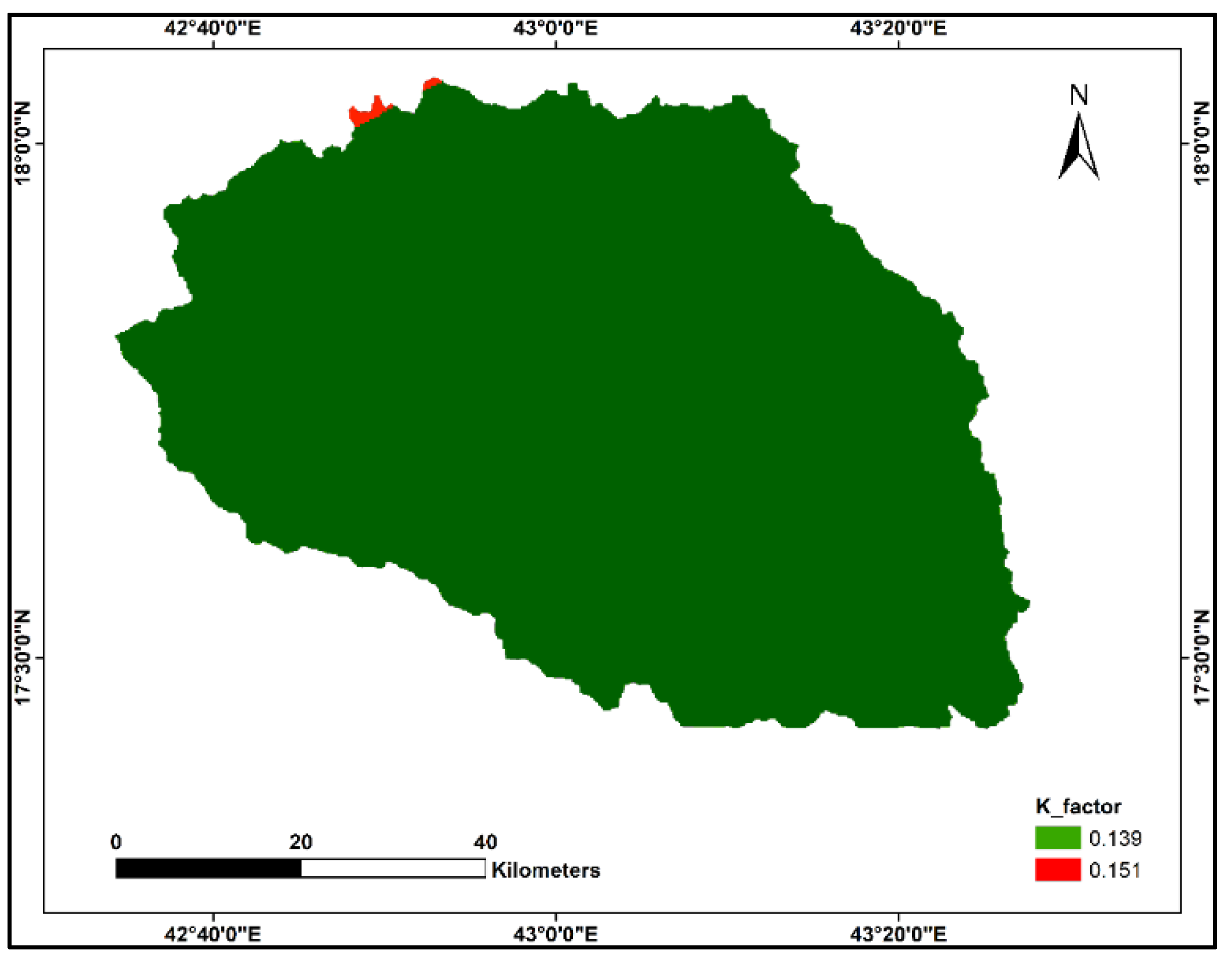
3.3.2. K Factor
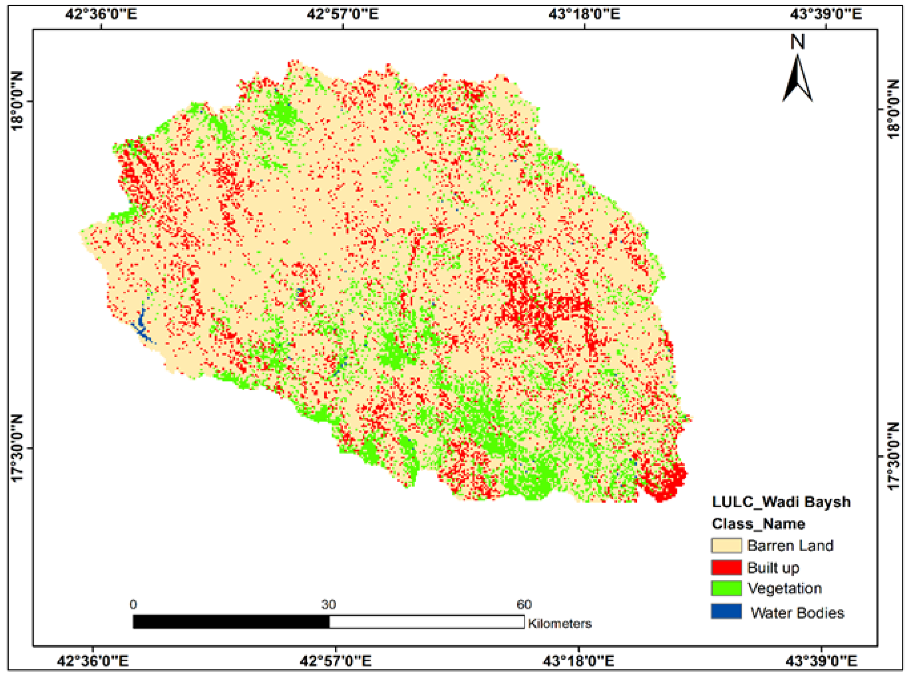
3.3.3. LULC Preparation
4. Results
4.1. RUSLE Model Parameters
4.1.1. R Factor
4.1.2. K Factor
4.1.3. LULC
4.1.4. Total Estimated Sediment Retention in the Basin
5. Discussion
6. Conclusions
- 1.
- R factor calculated using CHIRPS data was found very high in the mountainous regions, which showed a decreasing trend towards the steep slope of the study region. The distribution of R factor demonstrated that Wadi Baysh is extremely vulnerable to soil erosion, especially the northern areas of the basin. Overall, the average values of R factor range from 91.35 to 115.95 MJ mm/ha/h/year in the study area.
- 2.
- DSMW is used to calculate the K factor demonstrating the amount of eroded soil and the results revealed low to moderate soil erodibility. Since most of the study area is barren land (81%, estimated using the SVM algorithm), the K factor illustrated high potential of soil erosion as 58.9% and 75% of the area is comprised of sand in two types of soil classes, respectively.
- 3.
- The study area is classified into four major LULC classes, i.e., barren land, built-up, vegetation, and waterbodies. The study area comprises 81%, 11%, 8%, and 1% of barren land, vegetation, and water bodies, respectively.
- 4.
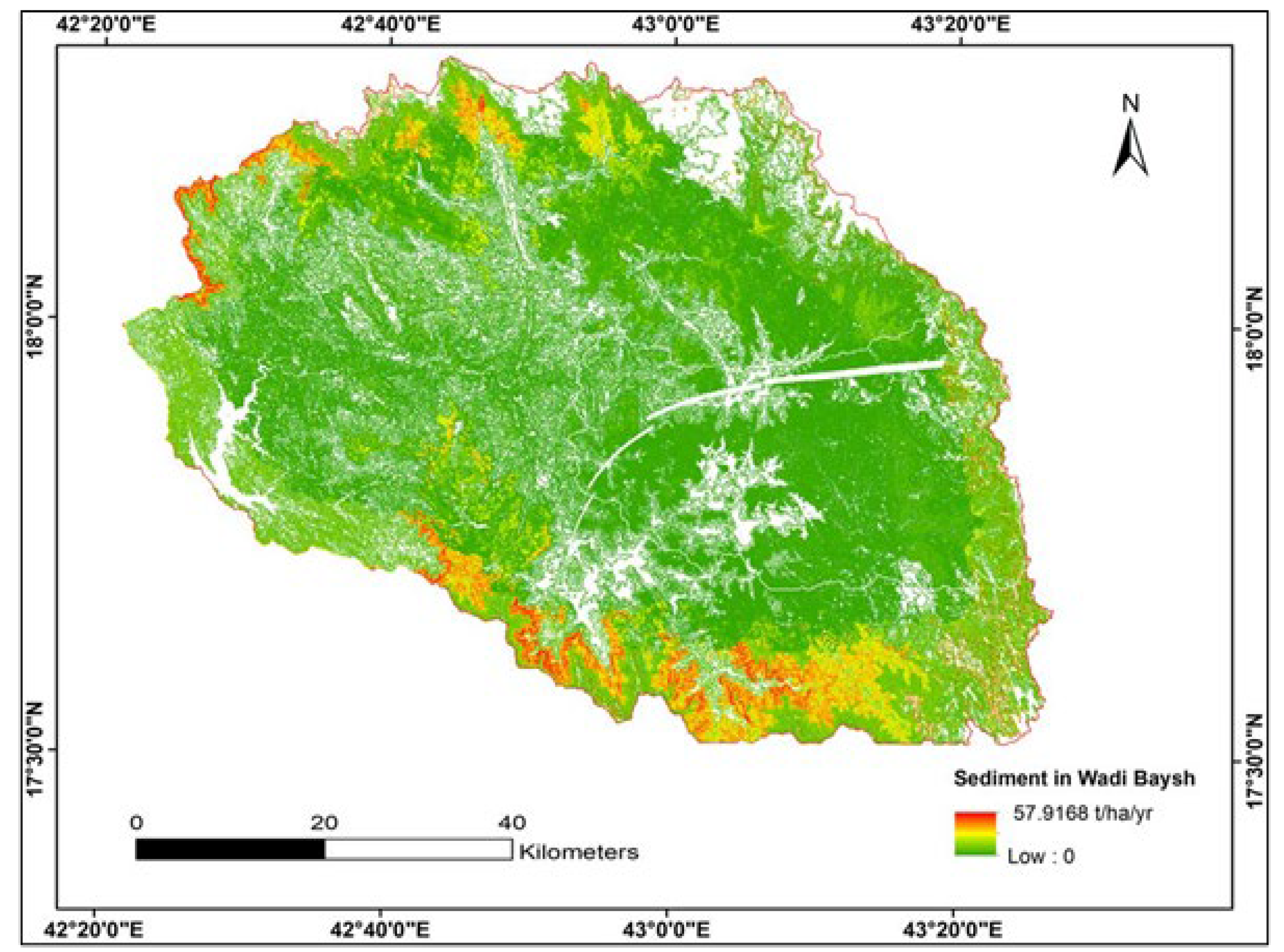
- The sediment retention map generated using the TerrSet model after transferring all the input data from the GIS environment showed a total sediment loss of 57.91 million tons at an annual scale. The mountainous regions in Wadi Baysh depicted high risk for soil erosion (with a magnitude of 57.91 tons/ha/year), which is decreasing towards the plan and urban areas.
- 5.
- Significant variations in soil loss are observed in the study area, which is associated with topography, agricultural practices, LULC, climate change, and erratic rainfall nature.
Author Contributions
Funding
Institutional Review Board Statement
Informed Consent Statement
Data Availability Statement
Acknowledgments
Conflicts of Interest
References
- Sundara Kumar, P.; Praveen, T.V.; Prasad, M.A.; Rao, P.S. Identification of critical erosion prone areas and computation of sediment yield using remote sensing and GIS: a case study on Sarada river basin. J. Inst. Eng. Ser. A 2018, 99, 719–728. [Google Scholar] [CrossRef]
- Yadav, A.; Satyannarayana, P. Multi-objective genetic algorithm optimization of artificial neural network for estimating suspended sediment yield in Mahanadi River basin, India. Int. J. River Basin Manag. 2020, 18, 207–215. [Google Scholar] [CrossRef]
- Chuenchum, P.; Xu, M.; Tang, W. Estimation of soil erosion and sediment yield in the Lancang–Mekong river using the modified revised universal soil loss equation and GIS techniques. Water 2019, 12, 135. [Google Scholar] [CrossRef]
- Walling, D.E. Measuring sediment yield from river basins. In Soil Erosion Research Methods; Routledge: Abingdon, UK, 2017; pp. 39–82. [Google Scholar]
- Pande, C.B.; Pande, C. Sustainable Watershed Development Planning; Springer: Berlin/Heidelberg, Germany, 2020. [Google Scholar]
- Jakubínský, J.; Pechanec, V.; Procházka, J.; Cudlín, P. Modelling of soil erosion and accumulation in an agricultural landscape—A comparison of selected approaches applied at the small stream basin level in the Czech Republic. Water 2019, 11, 404. [Google Scholar] [CrossRef]
- Tamene, L.; Park, S.; Dikau, R.; Vlek, P. Analysis of factors determining sediment yield variability in the highlands of northern Ethiopia. Geomorphology 2006, 76, 76–91. [Google Scholar] [CrossRef]
- Pimentel, D. Soil erosion: a food and environmental threat. Environ. Dev. Sustain. 2006, 8, 119–137. [Google Scholar] [CrossRef]
- Lal, R. Soil Erosion by wind and water: problems and prospects. In Soil Erosion Research Methods; RoutledgE: Abingdon, UK, 2017; pp. 1–10. [Google Scholar]
- Gisladottir, G.; Stocking, M. Land degradation control and its global environmental benefits. Land Degrad. Dev. 2005, 16, 99–112. [Google Scholar] [CrossRef]
- Bensekhria, A.; Bouhata, R. Assessment and Mapping Soil Water Erosion Using RUSLE Approach and GIS Tools: Case of Oued el-Hai Watershed, Aurès West, Northeastern of Algeria. ISPRS Int. J. Geo-Inf. 2022, 11, 84. [Google Scholar] [CrossRef]
- Les Sols, S. Exploiter Le Potentiel D’adaptation Du Carbone Organique Des Sols Au Changement Climatique. Available online: https://www.fao.org/3/i7268fr/I7268FR.pdf (accessed on 27 March 2022).
- Singh, G.; Panda, R. Grid-cell based assessment of soil erosion potential for identification of critical erosion prone areas using USLE, GIS and remote sensing: A case study in the Kapgari watershed, India. Int. Soil Water Conserv. Res. 2017, 5, 202–211. [Google Scholar] [CrossRef]
- Belnap, J.; Munson, S.; Field, J. Aeolian and fluvial processes in dryland regions: the need for integrated studies. Ecohydrology 2011, 4, 615–622. [Google Scholar] [CrossRef]
- Walker, B.; Steffen, W. An overview of the implications of global change for natural and managed terrestrial ecosystems. Conserv. Ecol. 1997, 1, 1662. [Google Scholar] [CrossRef]
- Ashiagbor, G.; Forkuo, E.; Laari, P.; Aabeyir, R. Modeling soil erosion using RUSLE and GIS tools. Int. J. Remote Sens. Geosci. 2013, 2, 1–17. [Google Scholar]
- FAO, I. Global Soil Status, Processes and Trends. In Status of the World’s Soil Resources (SWSR)–Main Report; Food and Agriculture Organization of the United Nations and Intergovernmental Technical Panel on Soils: Rome, Italy, 2015. [Google Scholar]
- Diyabalanage, S.; Samarakoon, K.; Adikari, S.; Hewawasam, T. Impact of soil and water conservation measures on soil erosion rate and sediment yields in a tropical watershed in the Central Highlands of Sri Lanka. Appl. Geogr. 2017, 79, 103–114. [Google Scholar] [CrossRef]
- Yeshaneh, G.T. Assessment of soil fertility variation in different land uses and management practices in maybar watershed, South Wollo Zone, North Ethiopia. Int. J. Environ. Bioremedi. Biodegrad 2015, 3, 15–22. [Google Scholar]
- Bahrawi, J.A.; Elhag, M.; Aldhebiani, A.; Galal, H.; Hegazy, A.; Alghailani, E. Soil erosion estimation using remote sensing techniques in Wadi Yalamlam Basin, Saudi Arabia. Adv. Mater. Sci. Eng. 2016, 2016, 9585962. [Google Scholar] [CrossRef]
- García-Ruiz, J.M.; Beguería, S.; Lana-Renault, N.; Nadal-Romero, E.; Cerdà, A. Ongoing and emerging questions in water erosion studies. Land Degrad. Dev. 2017, 28, 5–21. [Google Scholar] [CrossRef]
- Issaka, S.; Ashraf, M. Impact of soil erosion and degradation on water quality: a review. Geol. Ecol. Landsc. 2017, 1, 1–11. [Google Scholar] [CrossRef]
- El Jazouli, A.; Barakat, A.; Ghafiri, A.; El Moutaki, S.; Ettaqy, A.; Khellouk, R. Soil erosion modeled with USLE, GIS, and remote sensing: a case study of Ikkour watershed in Middle Atlas (Morocco). Geosci. Lett. 2017, 4, 1–12. [Google Scholar] [CrossRef]
- Vaezi, A.R.; Abbasi, M.; Keesstra, S.; Cerdà, A. Assessment of soil particle erodibility and sediment trapping using check dams in small semi-arid catchments. Catena 2017, 157, 227–240. [Google Scholar] [CrossRef]
- Montgomery, D.R. Soil erosion and agricultural sustainability. Proc. Natl. Acad. Sci. 2007, 104, 13268–13272. [Google Scholar] [CrossRef]
- Borrelli, P.; Robinson, D.; Panagos, P.; Lugato, E.; Yang, J.; Alewell, C.; Wuepper, D.; Montanarella, L.; Ballabio, C. Land use and climate change impacts on global soil erosion by water (2015–2070). Proc. Natl. Acad. Sci. USA 2020, 117, 21994–22001. [Google Scholar] [CrossRef] [PubMed]
- De Jong, S.; Paracchini, M.; Bertolo, F.; Folving, S.; Megier, J.; De Roo, A. Regional assessment of soil erosion using the distributed model SEMMED and remotely sensed data. Catena 1999, 37, 291–308. [Google Scholar] [CrossRef]
- Boardman, J. Soil erosion science: Reflections on the limitations of current approaches. Catena 2006, 68, 73–86. [Google Scholar] [CrossRef]
- Neitsch, S.L.; Arnold, J.; Kiniry, J.; Williams, J. Soil and Water Assessment Tool Theoretical Documentation Version 2009; Texas Water Resources Institute: College Station, TX, USA, 2011. [Google Scholar]
- Mitasova, H.; Hofierka, J.; Zlocha, M.; Iverson, L. Modelling topographic potential for erosion and deposition using GIS. Int. J. Geogr. Inf. Syst. 1996, 10, 629–641. [Google Scholar] [CrossRef]
- Natural Capital Project. Available online: https://naturalcapitalproject.stanford.edu/ (accessed on 27 March 2022).
- CLARKS LABS. Available online: https://clarklabs.org/about/ (accessed on 27 March 2022).
- Aslam, B.; Khalil, U.; Saleem, M.; Maqsoom, A.; Khan, E. Effect of multiple climate change scenarios and predicted land-cover on soil erosion: A way forward for the better land management. Environ. Monit. Assess. 2021, 193, 1–25. [Google Scholar] [CrossRef]
- El Jazouli, A.; Barakat, A.; Khellouk, R.; Rais, J.; El Baghdadi, M. Remote sensing and GIS techniques for prediction of land use land cover change effects on soil erosion in the high basin of the Oum Er Rbia River (Morocco). Remote Sens. Appl. Soc. Environ. 2019, 13, 361–374. [Google Scholar] [CrossRef]
- Masoud, M.H.; Basahi, J.; Zaidi, F. Groundwater resource management based on three-dimensional flow modeling of Wadi Baysh aquifer system: southwestern Saudi Arabia. Environ. Earth Sci. 2019, 78, 1–18. [Google Scholar] [CrossRef]
- Abu-Abdullah, M.M.; Youssef, A.; Maerz, N.; Abu-AlFadail, E.; Al-Harbi, H.; Al-Saadi, N. A flood risk management program of Wadi Baysh dam on the downstream area: An integration of hydrologic and hydraulic models, Jizan region, KSA. Sustainability 2020, 12, 1069. [Google Scholar] [CrossRef]
- ASF. Available online: https://search.asf.alaska.edu/#/ (accessed on 27 March 2022).
- Funk, C.; Peterson, P.; Landsfeld, M.; Pedreros, D.; Verdin, J.; Shukla, S.; Husak, G.; Rowland, J.; Harrison, L.; Hoell, A. The climate hazards infrared precipitation with stations—a new environmental record for monitoring extremes. Sci. Data 2015, 2, 1–21. [Google Scholar] [CrossRef]
- Sousa, K.D.; Sparks, A.; Ashmall, W.; Etten, J.; Solberg, S. chirps: API Client for the CHIRPS Precipitation Data in R. J. Open Source Softw. 2020. [Google Scholar] [CrossRef]
- Shahid, M.; Rahman, K.; Haider, S.; Gabriel, H.; Khan, A.; Pham, Q.; Mohammadi, B.; Linh, N.; Anh, D. Assessing the potential and hydrological usefulness of the CHIRPS precipitation dataset over a complex topography in Pakistan. Hydrol. Sci. J. 2021, 66, 1664–1684. [Google Scholar] [CrossRef]
- Food and Agriculture Organization of United Nations. Available online: https://www.fao.org/soils-portal/data-hub/soil-maps-and-databases/en/ (accessed on 27 March 2022).
- United Nation Geological Survey Earth Explorer. Available online: https://earthexplorer.usgs.gov/ (accessed on 27 March 2022).
- Helder, D.; Markham, B.; Morfitt, R.; Storey, J.; Barsi, J.; Gascon, F.; Clerc, S.; LaFrance, B.; Masek, J.; Roy, D. Observations and recommendations for the calibration of Landsat 8 OLI and Sentinel 2 MSI for improved data interoperability. Remote Sens. 2018, 10, 1340. [Google Scholar] [CrossRef] [Green Version]
- eoPortal. Available online: https://www.eoportal.org/satellite-missions/copernicus-sentinel-2#performance-specifications (accessed on 27 March 2022).
- Chuenchum, P.; Xu, M.; Tang, W. Predicted trends of soil erosion and sediment yield from future land use and climate change scenarios in the Lancang–Mekong River by using the modified RUSLE model. Int. Soil Water Conserv. Res. 2020, 8, 213–227. [Google Scholar] [CrossRef]
- Kenneth, G.R.; George, R.; Glenn, A.; Jeffrey, P. RUSLE: Revised universal soil loss equation. J. Soil Water Conserv. 1991, 46, 30–33. [Google Scholar]
- Tsegaye, L.; Bharti, R. Soil erosion and sediment yield assessment using RUSLE and GIS-based approach in Anjeb watershed, Northwest Ethiopia. SN Appl. Sci. 2021, 3, 1–19. [Google Scholar] [CrossRef]
- Maleika, W. Inverse distance weighting method optimization in the process of digital terrain model creation based on data collected from a multibeam echosounder. Appl. Geomat. 2020, 12, 397–407. [Google Scholar] [CrossRef]
- Liu, D.; Zhao, Q.; Fu, D.; Guo, S.; Liu, P.; Zeng, Y. Comparison of spatial interpolation methods for the estimation of precipitation patterns at different time scales to improve the accuracy of discharge simulations. Hydrol. Res. 2020, 51, 583–601. [Google Scholar] [CrossRef]
- Hurni, H. An ecosystem approach to soil conservation. In Soil Erosion and Conservation; El-Swaify, S.A., Moldenhauer, W.C., Lo, A., Eds.; Soil Conservation Society of America: Ankey, IA, USA, 1985; pp. 759–771. [Google Scholar]
- Singh, M.; Khera, K. Soil erodibility indices under different land uses in lower Shiwaliks. Trop. Ecol. 2008, 49, 113. [Google Scholar]
- Wawer, R.; Nowocien, E.; Podolski, B. Eal and calculated kusle erobility factor for selected Polish soils. Pol. J. Environ. Stud. 2005, 14, 655–658. [Google Scholar]
- Neitsch, S. Theoretical DocumentationErosion Soil and Water Assessment Tool; Texas Agricultural Eksperiment Station: Temple, TX, USA, 2000; p. 625. [Google Scholar]
- Adugna, T.; Xu, W.; Fan, J. Comparison of random forest and support vector machine classifiers for regional land cover mapping using coarse resolution FY-3C images. Remote Sens. 2022, 14, 574. [Google Scholar] [CrossRef]
- Balkhair, K.S.; Rahman, K.U. Development and assessment of rainwater harvesting suitability map using analytical hierarchy process, GIS and RS techniques. Geocarto Int. 2021, 36, 421–448. [Google Scholar] [CrossRef]
- Motlagh, Z.K.; Lotfi, A.; Pourmanafi, S.; Ahmadizadeh, S.; Soffianian, A. Spatial modeling of land-use change in a rapidly urbanizing landscape in central Iran: Integration of remote sensing, CA-Markov, and landscape metrics. Environ. Monit. Assess. 2020, 192, 1–19. [Google Scholar] [CrossRef] [PubMed]
- Parida, B.R.; Mandal, S. Polarimetric decomposition methods for LULC mapping using ALOS L-band PolSAR data in Western parts of Mizoram, Northeast India. SN Appl. Sci. 2020, 2, 1–15. [Google Scholar] [CrossRef]
- Daba, M.H.; You, S. Quantitatively assessing the future land-use/land-cover changes and their driving factors in the upper stream of the Awash River based on the CA–markov model and their implications for water resources management. Sustainability 2022, 14, 1538. [Google Scholar] [CrossRef]
- Jensen, J.R. Introductory Digital Image Processing: A Remote Sensing Perspective; Prentice-Hall Inc.: Hoboken, NJ, USA, 1996. [Google Scholar]
- Congalton, R.G. A review of assessing the accuracy of classifications of remotely sensed data. Remote Sens. Environ. 1991, 37, 35–46. [Google Scholar] [CrossRef]
- Maqsoom, A.; Aslam, B.; Hassan, U.; Kazmi, Z.; Sodangi, M.; Tufail, R.; Farooq, D. Geospatial assessment of soil erosion intensity and sediment yield using the revised universal soil loss equation (RUSLE) model. ISPRS Int. J. Geo-Inf. 2020, 9, 356. [Google Scholar] [CrossRef]
- Saleem, U.; Amjad, A.; Muhammad, I.; Muhammad, J.; Muhammad, I. Geospatial assessment of soil erosion intensity and sediment yield: a case study of Potohar Region, Pakistan. Environmental Earth Sciences 2018, 77, 1–13. [Google Scholar]
- Obaid, H.; Shahid, S. Soil erosion susceptibility of Johor River basin. Water Environ. J. 2017, 31, 367–374. [Google Scholar] [CrossRef]
- Tadesse, L.; Suryabhagavan, K.; Sridhar, G.; Legesse, G. Land use and land cover changes and Soil erosion in Yezat Watershed, North Western Ethiopia. Int. Soil Water Conserv. Res. 2017, 5, 85–94. [Google Scholar] [CrossRef]
- Azaiez, N.; Alleoua, A.; Baazaoui, N.; Qhtani, N. Assessment of soil loss in the Mirabah Basin: an overview of the potential of agricultural terraces as ancestral practices (Saudi Arabia). Open J. Soil Sci. 2020, 10, 159. [Google Scholar] [CrossRef]
- Elhag, M.; Hidayatulloh, A.; Bahrawi, J.; Chaabani, A.; Budiman, J. Using inconsistencies of wadi morphometric parameters to understand patterns of soil erosion. Arab. J. Geosci. 2022, 15, 1–14. [Google Scholar] [CrossRef]
- Moses, A. GIS-RUSLE interphase modelling of soil erosion hazard and estimation of sediment yield for river Nzoia basin in Kenya. J Remote Sens GIS 2017, 6, 1–13. [Google Scholar] [CrossRef]
- Xu, L.; Xu, X.; Meng, X. Risk assessment of soil erosion in different rainfall scenarios by RUSLE model coupled with Information Diffusion Model: A case study of Bohai Rim, China. Catena 2013, 100, 74–82. [Google Scholar] [CrossRef]
- Azaiez, N.; Baazaoui, N.; Blel, I.; Hammami, B. Contribution of the adjusted empirical analysis of the RSULE and FAO models in the estimation of soil losses in the watershed of Wadi El Hayat (Saudi Arabia). Arab. J. Geosci. 2021, 14, 1–18. [Google Scholar] [CrossRef]
- Wolka, K.; Tadesse, H.; Garedew, E.; Yimer, F. Soil erosion risk assessment in the Chaleleka wetland watershed, Central Rift Valley of Ethiopia. Environ. Syst. Res. 2015, 4, 1–12. [Google Scholar] [CrossRef]
- Tirkey, A.S.; Pandey, A.; Nathawat, M. Use of satellite data, GIS and RUSLE for estimation of average annual soil loss in Daltonganj watershed of Jharkhand (India). J. Remote Sens. Technol. 2013, 1, 20–30. [Google Scholar] [CrossRef]


| Data | Spatial Resolution | Source |
|---|---|---|
| Digital Elevation Model (DEM) | 12.5 m | ALOS PALSAR |
| Climate Data | 0.05° × 0.05° | CHIRPS Dataset |
| Soil Data | 30 m | DSMW Data |
| Land Use Land Cover | 10 m | Sentinel-2 Data |
| Parameters | Format for Parameter |
|---|---|
| Watershed | Raster file |
| Sub Watershed | Raster file |
| Land Use Land Cover | Raster file |
| DEM | Raster file |
| R Factor | Raster file |
| K Factor | Raster file |
| Sediment Threshold table | Numerical Value |
| Bio Physical table | Numerical Value |
| Geodata format | Idrisi file (.RST) |
| Soil Unit Symbol | Soil Type | Sand % | Silt % | Clay % | Organic Carbon % | Soil Type | K Factor |
|---|---|---|---|---|---|---|---|
| I | Lithosols | 58.9 | 16.2 | 24.9 | 0.97 | Loam | 0.139 |
| I | Lithosols | 75 | 15 | 10 | 0.31 | Loam | 0.151 |
| Land Cover | Barren Land | Built Up | Vegetation | Water Bodies | Total | User Accuracy | Commission |
|---|---|---|---|---|---|---|---|
| Barren Land | 50 | 6 | 2 | 1 | 59 | 84.75 | 15.25 |
| Built up | 2 | 13 | 0 | 0 | 15 | 86.67 | 13.33 |
| Vegetation | 1 | 1 | 8 | 0 | 10 | 80.0 | 20.0 |
| waterbodies | 0 | 0 | 0 | 8 | 8 | 100.0 | 0.0 |
| Total | 53 | 20 | 10 | 9 | 92 | ||
| Producer Accuracy | 94.33 | 65.0 | 80.0 | 88.89 | |||
| Omission | 5.67 | 35.0 | 20.0 | 11.11 | |||
| Kappa | 0.76 | ||||||
| Overall Accuracy | 86 |
Disclaimer/Publisher’s Note: The statements, opinions and data contained in all publications are solely those of the individual author(s) and contributor(s) and not of MDPI and/or the editor(s). MDPI and/or the editor(s) disclaim responsibility for any injury to people or property resulting from any ideas, methods, instructions or products referred to in the content. |
© 2023 by the authors. Licensee MDPI, Basel, Switzerland. This article is an open access article distributed under the terms and conditions of the Creative Commons Attribution (CC BY) license (https://creativecommons.org/licenses/by/4.0/).
Share and Cite
Ejaz, N.; Elhag, M.; Bahrawi, J.; Zhang, L.; Gabriel, H.F.; Rahman, K.U. Soil Erosion Modelling and Accumulation Using RUSLE and Remote Sensing Techniques: Case Study Wadi Baysh, Kingdom of Saudi Arabia. Sustainability 2023, 15, 3218. https://doi.org/10.3390/su15043218
Ejaz N, Elhag M, Bahrawi J, Zhang L, Gabriel HF, Rahman KU. Soil Erosion Modelling and Accumulation Using RUSLE and Remote Sensing Techniques: Case Study Wadi Baysh, Kingdom of Saudi Arabia. Sustainability. 2023; 15(4):3218. https://doi.org/10.3390/su15043218
Chicago/Turabian StyleEjaz, Nuaman, Mohamed Elhag, Jarbou Bahrawi, Lifu Zhang, Hamza Farooq Gabriel, and Khalil Ur Rahman. 2023. "Soil Erosion Modelling and Accumulation Using RUSLE and Remote Sensing Techniques: Case Study Wadi Baysh, Kingdom of Saudi Arabia" Sustainability 15, no. 4: 3218. https://doi.org/10.3390/su15043218
APA StyleEjaz, N., Elhag, M., Bahrawi, J., Zhang, L., Gabriel, H. F., & Rahman, K. U. (2023). Soil Erosion Modelling and Accumulation Using RUSLE and Remote Sensing Techniques: Case Study Wadi Baysh, Kingdom of Saudi Arabia. Sustainability, 15(4), 3218. https://doi.org/10.3390/su15043218