1. Introduction
Global urbanization since the industrial revolution has changed the way human lives [
1,
2]. Currently, the number of urban dwellers in the world has surpassed the number of rural dwellers, with the former accounting for 55% of the world population in 2018 [
3]. However, the other side of urban development is the decay of the countryside. Admittedly, the trend of rural decay is an inevitable by-product of urbanization. However, on the one hand, experiences of world urbanization show that the level of urbanization will not reach 100%. This means that even at the terminal stage of urbanization, the countryside will still exist [
4]. On the other hand, the decay of the countryside is a long-term process. From a humanitarian point of view, it is inappropriate to be unconcerned about the fate of the people who must live in the decaying villages. In particular, attention to rural decay is of special significance in developing countries [
5,
6,
7]. Unlike developed countries, where the urban-rural divide can be seen as a difference in lifestyle [
8], that in developing countries is more of the disparity in living standards. In China, for example, the urban-rural income gap reached 2.69 times in 2018 [
9]. The decay of the countryside, then, would worsen the conditions in the already poor villages. Economically, rural decay brings a labor shortage, making it impossible to meet the necessary threshold for an agglomeration economy [
10,
11]. Economic recessions, in turn, lead to various problems, including inefficient use of land and other resources, out-migration that creates hollow villages or large numbers of left-behind children and elderly people, and the destruction of rural cultural traditions, among other social and cultural challenges [
6]. More seriously, the loss of developmental momentum accompanying the above processes would create a downward spiral of negative feedback loops, making it difficult for villages to avoid falling into the above traps through their efforts [
5]. Therefore, it is essential to implement public policy interventions to avoid the looming prospects of village decay.
China, with its rapid urbanization, is facing the village decay problem, the extent and intensity of which is an extremely prominent example in the developing world [
12]. To address the problem, the Chinese central government adopted the Strategic Plan for Rural Revitalization (2018–2022) (the Plan, hereafter) on 31 May 2018. The Plan proposes to divide all villages into four types, including (1) Agglomerative Promotion, (2) Suburban Annexation, (3) Special Endowment-based Development, and (4) Out-migration and Relocation. As their names suggest, the meanings of the four types are straightforward. Among them, the first three types of villages have certain factor endowments such as locational advantages or special economic and/or cultural resources, and the Plan supports their revitalization in different forms. The fourth category of villages, however, lacks the necessary endowments for development, and the Plan implies that they will eventually disappear through “Out-migration and Relocation”. The typology of the Plan based on factor endowments is in line with the basic theory of development economics [
13,
14], and is also embedded in the idea of rural typology [
15]. Rural typology asserts that rural land can be divided into identifiable and relatively homogeneous units and that the identification of such units facilitates the understanding of rural character, administration, and policymaking [
15,
16,
17,
18]. The Plan, though, does not specify how the four types of villages are identified, nor does it give any zoning maps of the distribution of the four types of villages across the country at any granularity. Admittedly, at the national scale, it is difficult to make such zoning for millions of villages, not to mention that the formulation of specific rural revitalization policies is also a local rather than a central matter. Nevertheless, it is still meaningful to examine the country’s rural typology by means of geographic zoning, to identify the types of villages based on their factor endowments, and to determine their prospects of revitalization or decay. On the one hand, for villages with revitalization potential, policymakers can take measures to assist their development and facilitate their transformation into the appropriate types specified in the Plan. On the other hand, for villages that will inevitably decay, measures can also be taken to make the process of their demise smooth and orderly, such that long and unnecessary suffering for the villagers concerned can be avoided. Overall, a national-level rural typological zoning for rural revitalization can help provide basic, directional guidance for local-level policymaking, and is thus is a very necessary task.
Conventionally, the main method of rural typological classification has been experience-based qualitative analysis [
19,
20]. Nevertheless, when faced with extensive geographical scopes and a massive number of villages, the complexity of the classification problem would increase dramatically, rendering qualitative methods inadequate. This has led to the development of quantitative methods for rural typological classification, especially those based on elemental overlay analysis, where the elements considered typically include demographic, economic, social, and environmental factors [
20,
21,
22]. For example, van Eupen et al. developed a research framework using a range of geographic and socioeconomic data such as economic density and transportation accessibility to classify European rural areas into peri-urban, rural, and deep rural categories [
15]. Li et al. used fifteen variables on rural population density, age structure, education level, employment, migration, and housing conditions to conduct an assessment of rural types in China [
23]. Rusu used 25 indicators of climate change, population density, modernization, intensification, financial capital, and education level under a two-level classification system to distinguish spatial differences in rural vulnerability in the Danube region using factor analysis and cluster analysis [
24]. Beyazli et al. used multivariate statistical analysis techniques to typify rural villages in the Black Sea region of Turkey based on 43 variables such as population and migration, economic structure, transportation and accessibility, quality of life and welfare, environmental issues, and pressure on natural resources [
16]. We can find from the context of the literature that the indicators involved in rural typology have become increasingly rich, the typology more detailed, and the methods more developed, including principal component analysis and spatial clustering [
25]. These studies have established a modern paradigm for the quantitative classification of village types, and their analytical framework sheds light on the following studies. However, to the best of our knowledge, no work has been done so far with a geographical scope of an entire country and the objective of determining the prospects of rural revitalization or decay, thus leaving a prominent knowledge gap.
The presented work provides an attempt to fill this knowledge gap. Following the general paradigm of rural typology classification, this paper establishes a set of index systems from the perspective of factor endowments, which includes natural and human geographic elements such as terrain topography, landscape type, natural ecology, population, economy, and society. On this basis, we develop a new analytical framework, which features a Self-Organizing Map (SOM) approach that conducts spatial clustering with integrated geographic proximity and endowment similarity concerns. We then classify the villages throughout China into the four types per the direction of the Plan, as well as subtypes wherever applicable. We spatially visualize the results, thus giving a panoramic map of the types of rural revitalization for the entire country. We then propose roadmaps for rural revitalization according to the endowment conditions of each type of village, especially the “Special Endowment-based Development” type of village. Finally, we conclude the paper with discussions on the policy implications, scaling and implementation problems, and limitations of the work. Overall, this study seeks to answer the following research question: how the material endowments of villages will affect their prospects of rural revitalization in China from a rural typology perspective and provide a baseline solution at the national scale.
2. Methodology
The first methodological task of this study is to establish a system of indicators for evaluating the current status and potential of rural revitalization in China from the perspective of factor endowments. Based on a review of literature on rural typology, the factors affecting village development can be divided into three main categories [
16]. The first category is socioeconomic indicators, which mainly include population size and density, labor force, employment, basic education, health care, market services, location, and other factors [
21,
22,
26]. Among them, location factors mainly refer to transportation accessibility, which can usually be calculated based on multi-modal accessibility of road and rail transportation [
15,
27,
28]. The second category is natural environmental indicators, which include land cover, arable land per capita, forest area per capita, pressure on natural resources, hazard density, scale and intensity of mining activities, solid waste, etc. [
15,
29,
30]. The third category is the “change” factor of the village. Rural development is not a static process, and the above-mentioned demographic, economic, climatic, and land indicators need to be viewed from a dynamic perspective and used as the basis for formulating rural policies for development [
23,
31,
32]. Considering the obvious development orientation in rural revitalization, we have reclassified the above indicators into five groups from the perspective of factor endowments: natural environment, transportation location, socio-economic conditions, cultural and landscape resources, and special resources for first-industry development. Here, it is worth pointing out that the above indicator system is entirely based on material factor endowments and does not sufficiently consider non-material factors, such as the cultural genes of villages, social networks, and the role of local elite figures. For example, in the Chinese context, rural elites are important players in the rural socioeconomic system, and the resulting rural network relationships are important factors influencing village development [
33]. However, on the one hand, at the national scale, the non-material factors are either difficult to quantify or lack the necessary data sources due to statistical difficulties. On the other hand, considering that material endowment is the basis of rural development, while the role of non-material factors is secondary in strengthening or weakening the role of a material endowment. On balance, this study does not consider all kinds of non-material factors.
Next, we construct a spatial hierarchical clustering model based on the above indicator system of factor endowments. We first identify villages with a good natural endowment, socio-economic condition, and convenient economic location using the first three groups of factors. We then classify these villages into two categories, namely the Agglomerative Promotion and Suburban Annexation categories. Among them, the Agglomerative Promotion category includes the villages with good natural conditions, demographic and economic conditions, and economic locations, which make them suitable for expansion into larger settlements. Villages in the Suburban Annexation category are similar to them in terms of factor endowments, but their location is close to a central city, making them more prone to be annexed by the latter. Secondly, for villages that do not belong to the above two categories, the second round of clustering is conducted to filter out the Special Endowment-based Development category of villages based on their possession of special resources. Villages of this type have unique cultural landscape resources or agricultural resources, which can be used as the basis for economic revitalization based on competitive industrial development. The rest of the villages belong to the Out-migration and Relocation category. The overall analytical framework is shown in
Figure 1. It is worth pointing out that the first step of clustering does not consider the villages’ possession of special resources, thus ruling out the existence of Special Endowment-based Development in the first two types of villages. This is because, generally speaking, urbanization drives the village economy much more than any special primary industry [
14,
34]. Thus, we argue that the prioritization here is reasonable.
Regarding the basic spatial analysis unit, there is no doubt that it is ideal to classify village types at the village level. However, this paper still implements rural typology at the township level, for two reasons. First, because village-level data are not available. Few statistical indicators for the basic data mentioned above are available at a national scale below the county level, and the super-resolution enhancement reached through naïve interpolation is not meaningful. The second is because village-level administrative divisions change very frequently. Therefore, the classification at the village level lacks a feasible basis and practical significance. On the contrary, townships are a feasible and meaningful spatial unit. As of the end of 2016, there were 48,322 townships in China; while the number of villages, which cannot be counted precisely due to their more variable nature, is roughly 700,000 in jurisdiction terms or 3,000,000 in “natural settlement” terms. Thus, on average, a township has an approximate area of 200 km2 and includes 14 village jurisdictions. Based on these figures, and considering the availability of data and the practical significance of the zoning results, townships are already a small enough unit for a national-scale analysis, and the rural-type classification based on them can adequately reflect the situation at the village level, so it seems to be an acceptable compromise to use townships as the unit for rural revitalization classification and zoning.
2.1. Construction of the Rural Revitalization Factor Endowments Indicator System
Based on the literature on rural typology and considering the characteristics of rural China, we develop a village classification indicator system. Based on the aforementioned literature [
16], there are three main categories of factors affecting village development: natural environmental, socioeconomic, and “change” factors. Accordingly, we designate the natural environmental, socioeconomic, and transportation location indicators as the three primary indicators. Secondly, considering the diversity of “special endowments” on which the revitalization of villages in the category of “Special Endowment-based Development” depend, and the fact that their development is mostly driven by cash-crop agriculture and tourism, we designate a fourth agricultural resource indicator to characterize the agricultural factor endowments, and a fifth cultural landscape resources indicator to characterize the tourism factor endowments. Thus, five primary indicators are identified. Among them, the natural environment indicator includes four secondary factors, namely, topographic elevation, topographic slope, key areas for species protection, and ecological sensitivity; the socio-economic indicator includes two secondary factors, namely, population and GDP; the transportation location indicator includes two secondary factors, namely, accessibility of railroad transportation and accessibility of road transportation; the cultural landscape resources indicator includes 11 secondary factors, namely, nature reserves, national forest parks, national wetland parks, national desert parks, national geological parks, etc.; finally, the agricultural resource indicator includes 25 secondary factors, such as grain crop production, oilseed production, cotton production, medicinal herbs production, aquatic production, fresh-cut flowers production, etc. (
Table 1).
2.2. Spatial Clustering Considering Endowment Attributes
Rural type zoning is an attribute-weighted spatial clustering, and the Self-Organizing Map neural network approach can properly perform this task. Self-Organizing Map (SOM), also known as Kohonen’s network, is an unsupervised learning network that incorporates a large number of features that mimic the neuronal signal processing mechanism of the human brain [
35,
36]. By automatically searching for intrinsic patterns and essential properties in samples, this neural network optimizes the network parameters and structure in a self-organizing and adaptive manner and is widely used in the fields of clustering, data compression, feature extraction, and high-dimensional visualization [
37].
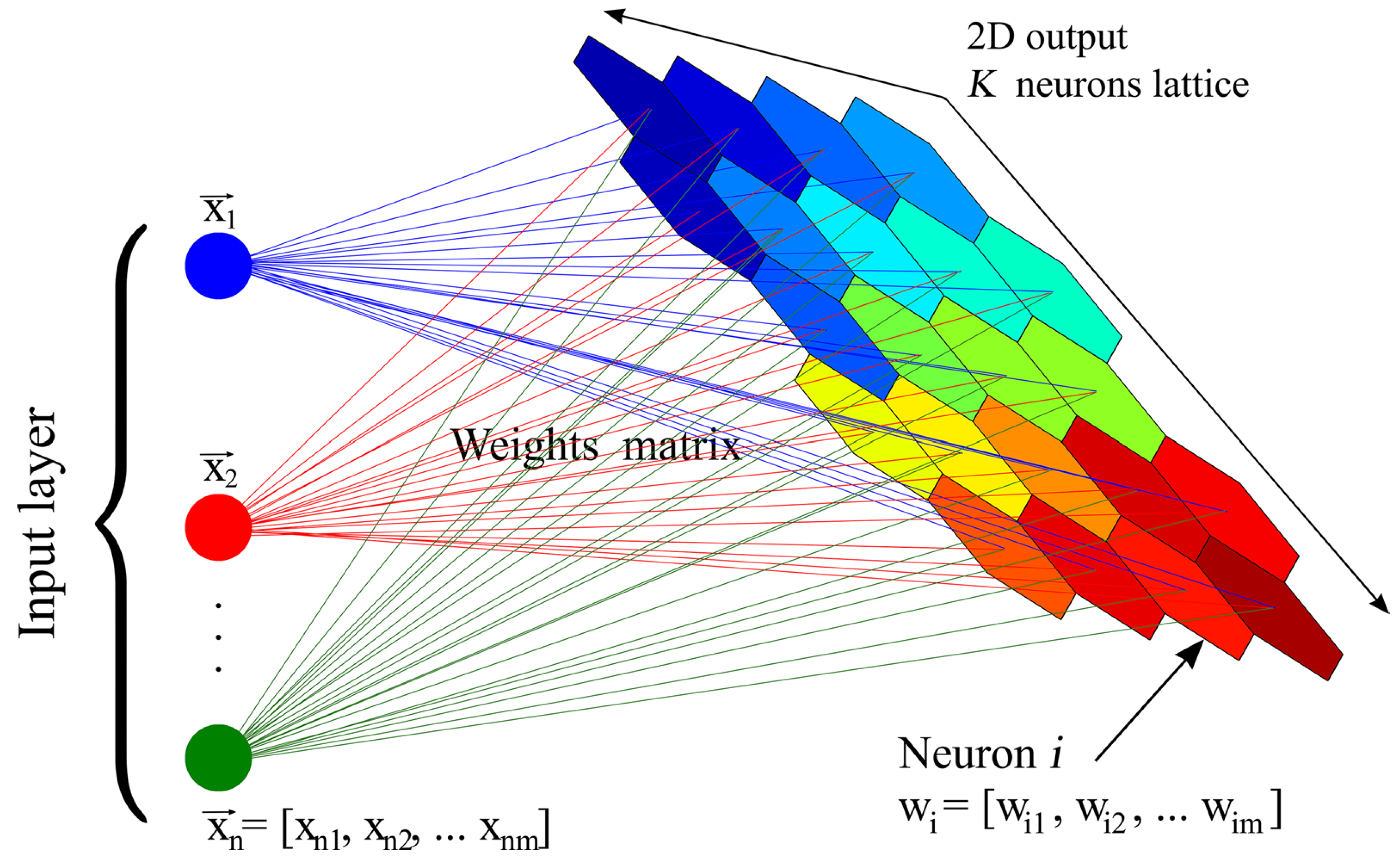
The basic structure of a SOM consists of two layers: an input layer and a competing layer (output layer), with no connections within the layers and full connections between the layers (
Figure 2). The input layer simulates the retina, which perceives external input, and the output layer simulates the cerebral cortex, which response. Each neuron in the input layer pools external information to each neuron in the output layer by means of a weight vector. The SOM uses a competitive learning mechanism to achieve self-organized clustering of input samples, where points with similar features are adjacent to each other in the clustering space. Among them, the number of neurons in the competitive layer is usually the number of clusters, representing each class that needs to be clustered into, and the nodes in the competitive layer have topological relationships, containing one-dimensional line arrays, two-dimensional planar arrays, three-dimensional raster arrays, etc. In this study, a two-dimensional planar array composed of hexagons is used. The SOM is trained by “competitive learning”, where each input sample finds a neuron in the competitive layer that matches it best, called the activation neuron; the parameters of the activation neuron are updated by the stochastic gradient descent method, and the neurons close to the activation neuron are also updated according to their distance from the activation neuron. The parameters are updated appropriately according to their distance from the activating neuron. In this study, the input layer represents the feature space of clustered samples, which corresponds to the various levels of indicators of village types, and the output layer represents the target clustering space, which corresponds to the village types.
In this study, Matlab® is used to implement the SOM model and perform the clustering analysis. The specific algorithms are described as follows.
(1) Weights initialization. Each neuron in the output layer is connected to a vector of weights of neurons in the input layer, representing the possible class centers. Therefore, a random value in the value domain of the corresponding feature variable is set as the initial value w of the connected weights.
(2) The algorithm randomly selects a certain sample vector xn in the sample set for input.
(3) The algorithm calculates the distance between the weight vector and the input vector in the output layer, using the Euclidean distance:
(4) The algorithm selects the neuron with the smallest distance from the weight vector as the best matching neuron (activating neuron) c and gives its set of neighboring neurons Nc.
(5) Weights adjustment. The algorithm adjusts the weights of the activating neuron and its neighboring neurons according to the following rules:
where
denotes the learning step and
h(
t) denote the domain size.
(6) If , then , repeat step (2).
(7) , repeat step (2) until the network converges.
2.3. Data Sources
This study uses the 2016 Chinese township boundaries as the spatial unit of analysis (excluding Taiwan Province). The data for the natural environment indicators are the elevation, slope distribution, species protection critical areas, and ecological sensitivity; the first two are publicly available data, and the latter two are mainly calculated by overlaying basic factors such as slope, elevation, soil, and climate. For socioeconomic indicators, the 2010 population and GSP spatial distribution 1-km grid datasets are based on the national county-level census and economic statistical data, which are super-resolution transformed taking into account multiple factors closely related to population and GDP such as land-use type, nighttime light brightness, the density of residential sites, etc. The multi-factor weight assignment method is then used to distribute the population and GDP data onto the regular spatial grids [
39]. The road accessibility is measured by the cost distance from each grid to the location of the county towns based on the 2013 road network data at all levels (including highways, national roads, provincial roads, county roads, and village roads), where the resistance values are obtained using the reciprocals of the designated speeds of each level of roads corrected by the slope of the terrain. The railroad traffic accessibility is calculated based on the density of railway lines in the counties. Cultural landscape resources, such as the distribution of national nature reserves, national forest parks, national wetland parks, etc. are obtained by geocoding of the open-source address information, and then assigning the corresponding service radius to get the density distribution map. Lastly, most of the various crops production data are obtained from the provincial statistical yearbooks [
9]. For the missing data in the yearbooks, the data for Heilongjiang Province is obtained from the 2017 statistical yearbook of each city in the province; the production data of Qinghai Province, Jiangxi Province, and Shanghai Municipality are obtained by proportionally distributing the prefecture-level data based on the county-level population and areas. The variable values for cultural landscape resources and agricultural resources are then assigned based on the presence or absence of these resources in each grid, with 1 representing presence and 0 representing absence. The specific sources for the data are shown in
Table A1 in
Appendix A, and an overlay of the data is shown in
Figure 3.
3. Results
3.1. Categorization of the Four Rural Revitalization Types
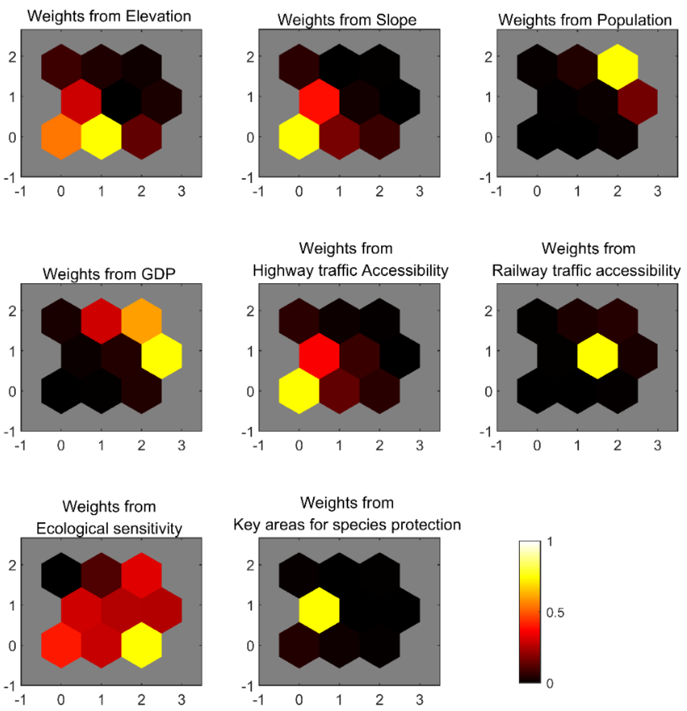
Figure 4 presents the weight planes of each SOM feature, which shows the weights of the 8 input features for different neurons. The original result gives 9 categories, and each hexagon in each subplot represents the categories 9-7, 6-4, 3-1 from the bottom to the top of each row. the brighter the color of the hexagon, the greater the contribution of the corresponding feature to the classification of that category, and vice versa. As can be seen, the weight planes reflect the contribution of different features to the classification of township categories, and the 9 original clusters can be accordingly assigned to the appropriate semantic category. For example, categories 1 and 4 t the Suburban Annexation type, whose classification characteristics are mainly contributed by the population and GDP features: intuitively, the Suburban Annexation type tends to be a more populated and economically developed township. Similarly, category 8 represents the Agglomerative Promotion type, which requires good natural and economic geographical conditions as a foundation, including good elevation, slope, and transportation conditions, and these features are also reflected in the weight planes.
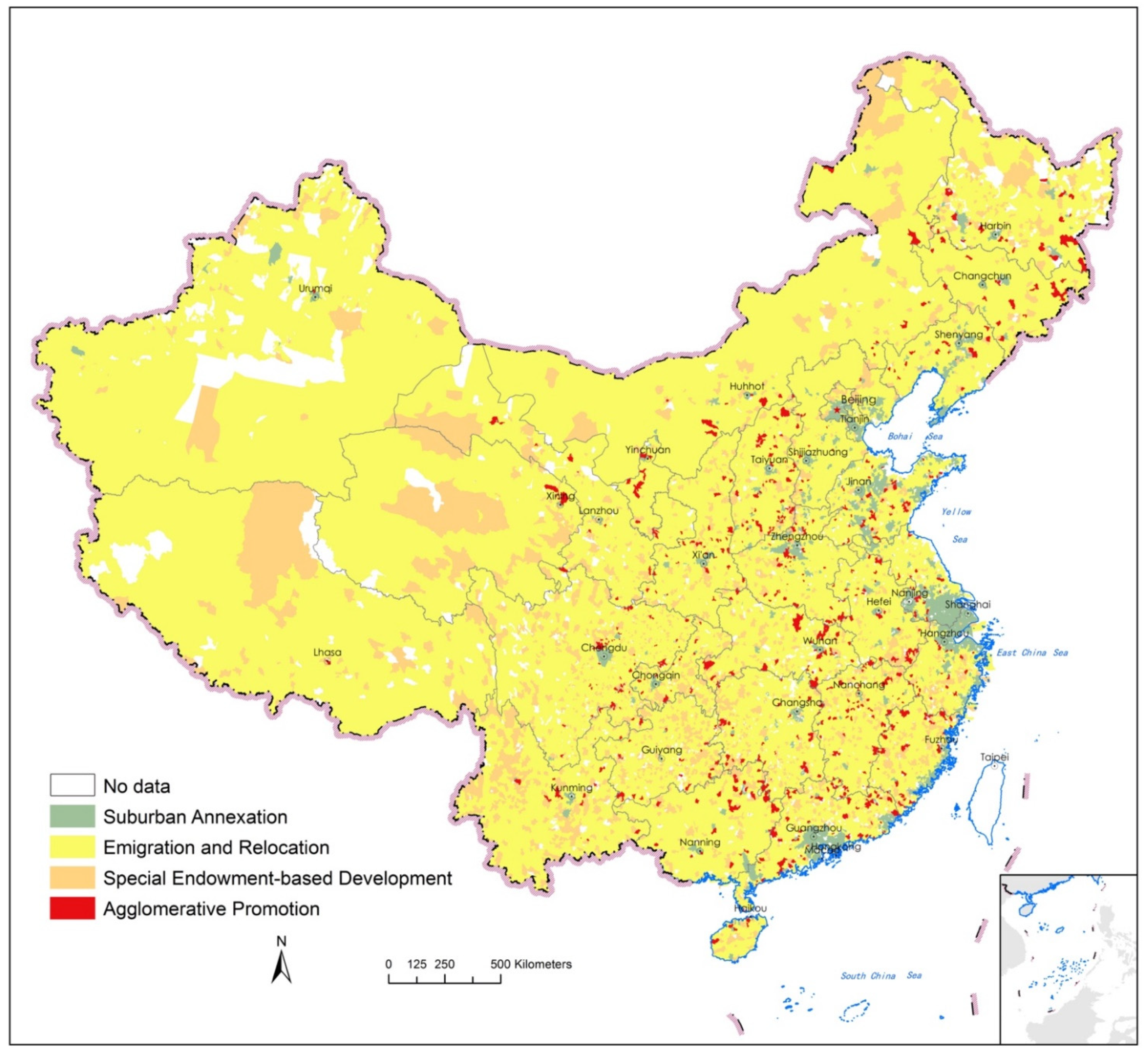
Based on the SOM weight planes, the results of the four types of rural revitalization are shown in
Figure 5 in the form of a zoning map, in which the number of each type of village is counted in
Table 2. Overall, most of the villages in the country belong to the Out-migration and Relocation category, accounting for 67.0% of all townships or 71.2% of all villages. These villages are generally located in geographically remote or inaccessible areas and lack any noteworthy industrial or other factor endowments. In contrast, the category with the lowest percentage (counted in townships) is the Agglomerative Promotion, accounting for 3.9% of all townships or 7.3% of all villages. These villages are mainly located in economically developed areas with dense populations and good transportation locations. Next, the Suburban Annexation category is mainly clustered along major transportation routes in the three major economic zones of Beijing, Shanghai, and Guangzhou or near the provincial capitals, accounting for 17.8% of all townships or 15.4% of all villages. The last category, namely the Special Endowment-based Development category, accounts for 11.3% of all townships or 6.1% of all villages. These villages have certain special factor endowments, including either or both cultural landscape resources and agricultural resources, and thus have the prospect of sustained development through differentiated competition. One interesting finding is that although the Special Endowment-based Development category takes a much larger portion than the Agglomerative Promotion category as counted by townships, these townships cover fewer villages than the latter does. This is another demonstration of the agglomerative nature of the latter category, further support for the findings.
3.2. Sub-Categorization of the “Endowment-Based Development” Type
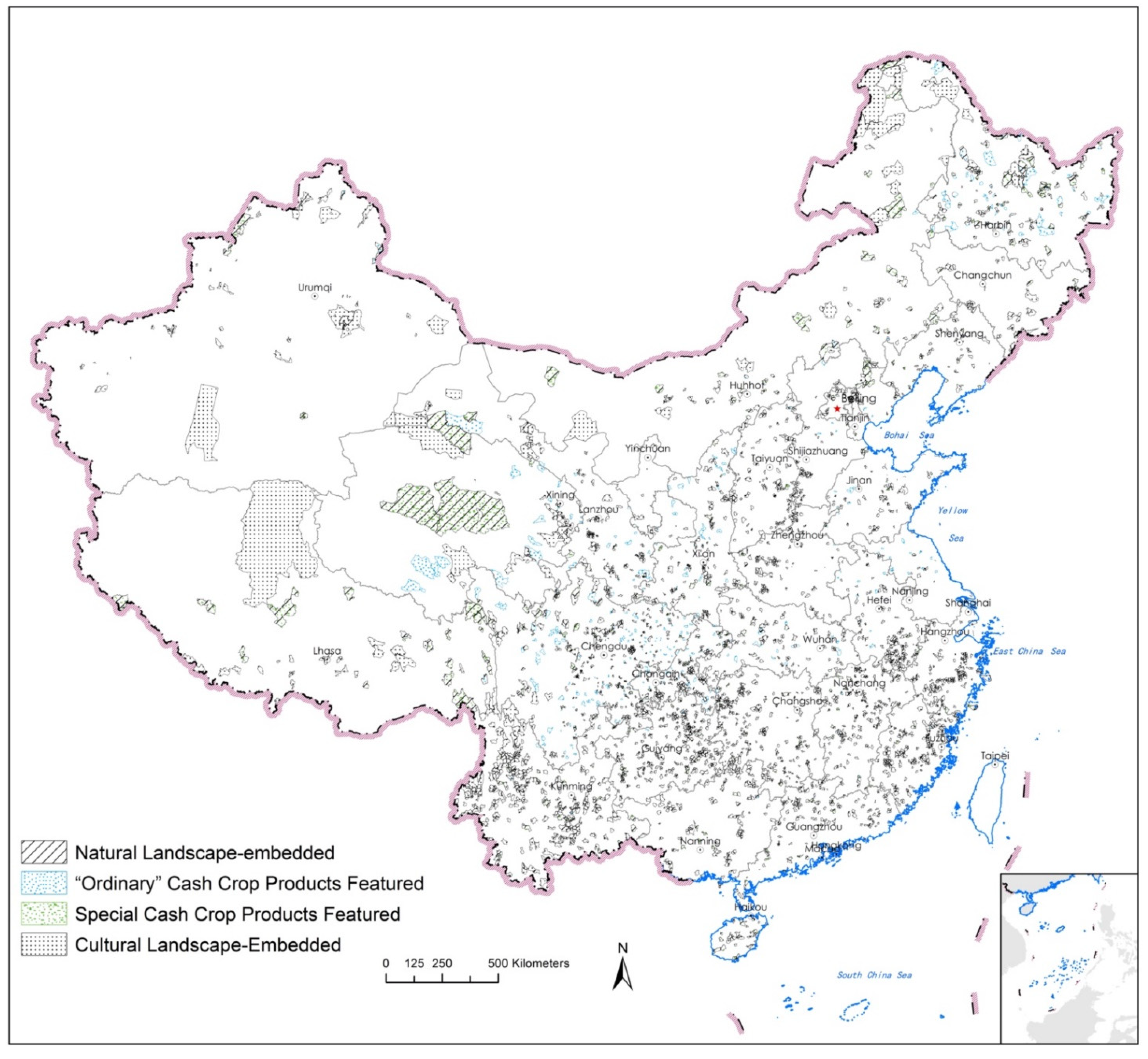
Based on their possession of different cultural or agricultural resource endowments, the second round of clustering of the villages in the Special Endowment-based Development category show that they could be further subdivided into four sub-types: Natural Landscape-Embedded, Cultural Landscape-Embedded, “Ordinary” Cash Crop Products Featured, and Special Cash Crop Products Featured (
Figure 6). Overall, we summarize the natural and socioeconomic characteristics, as well as their possession of special factor endowments of all types and sub-types of villages in
Table 3.
3.3. Paths of Rural Revitalization as Indicated by the Categorization Results
The four village types given in the clustering analysis confirm the rationality of the four rural revitalization paths in the Plan, and the division of the four subtypes of villages in the Special Endowment-based Development category in the second clustering step deepens the connotation of this rural typology system. Based on the specific factor endowments of each type and subtype of villages as reflected in the clustering results, targeted development strategies can be proposed for each of them.
Firstly, the majority of the villages are in the Out-migration and Relocation category, or simply the “Dissolution” type. These villages lack necessary economic locational advantages for attracting capital or human resources to ensure sustained economic development, nor do they possess any particular factor endowments for differentiated competitive advantages. In a market economy, villages with these characteristics will eventually disappear through population loss. Although, this process may be lengthy, and those groups that fall behind in the process of out-migration may suffer from the economic decline accompanying the process. At the same time, given that this type of village accounts for the majority of the rural population, if they disappear too quickly, their out-migration may put enormous pressure on cities and other villages. Therefore, policymakers must intervene in the disappearance process of these villages in a timely and appropriate manner by formulating relocation compensation policies, or granting living subsidies, and improving social, security supports, to accelerate or delay their disappearance whenever appropriate. We will elaborate on the specific policy choices in the Conclusion and Discussion section.
Secondly, the villages in the Agglomerative Promotion and Suburban Annexation categories, or simply the “Consolidation” and “Urbanization” types, respectively, have the necessary economic locational advantages, among which the latter further has the locational advantage of proximity to major cities, and both have the necessary conditions to develop and grow on their economic momentum. They are also one of the main destinations to take over the population and industries moved out from the relocated and merged villages. Among them, the former has the potential to grow into “central villages” or even township-level settlements, which may require policy support in terms of infrastructure construction and industrial guidance. The latter is located within the radiation range of the central cities and will be naturally merged into them as the cities expand. Therefore, policies that promote the synergistic development of such villages and cities in terms of construction, economy, and society may be necessary, which we will also elaborate on in the Conclusion and Discussion section.
Villages in the Special Endowment-based Development category, or simply the “Diversification” type show a high degree of diversity and should not be generalized in terms of development strategies. Among them, villages in the Natural Landscape-Embedded sub-type have resources such as nature reserves, national forest parks, national wetland parks, national desert parks, national geological parks, and national water parks that have been recognized by the national protected area system. These protected areas have profound natural and ecological values. They are sensitive and fragile areas for ecological protection on the one hand, and are socio-economically important on the other, and are thus facing the challenge of properly balancing the needs for natural ecological protection and socio-economic development. Policymakers may designate different levels of protection for different layers in nature reserves, which would intensify protection in the core layer and allow tourism and recreational activities in the peripheral layer wherever could carry a certain number of human activities, to promote the sustainable and synergistic development of local socio-ecological systems. Similarly, villages in the Cultural Landscape-Embedded sub-type have historical and cultural cities, towns, villages, 5A scenic spots, traditional villages, and key cultural relics protection units that have also been recognized by the national cultural heritage system. Like nature reserves, cultural heritage has the same problem of being sensitive and vulnerable to external impacts. Therefore, although it is an obvious path for such villages to develop tourism and recreation industries based on their cultural resource endowments, attention should also be paid to the trade-off between development and protection. For the remaining two sub-types of villages in the Special Endowment-based Development category, the “Ordinary” Cash Crop Products Featured sub-type villages are mainly endowed with agricultural products such as grain, oilseeds, cotton, meat, fruits, vegetables, and poultry eggs. Although these products are produced in most regions of the country, the identified villages with special yield advantages still have an important strategic position. These villages need to grasp their yield advantages, rely on key products for development, and then strive to drive the development of deep processing and other industries. Villages in the Special Cash Crop Products Featured sub-type have advantages in highly distinctive primary industries such as dairy, herbs, aquaculture, flowers, tea, silk, sugar, tobacco, and special mountain, water, and livestock products. These specialty industries are relatively rare at the national level, and thus they occupy a sort of monopoly advantage. Villages with highly distinctive industries need to persist in developing their distinctive industries to consolidate their differentiated advantages and ensure that their highly distinctive factor endowments contribute to the sustained economic development of the village in the long run. Finally, there are a small number of villages with multiple characteristic endowments at the same time. For such villages, it is necessary to analyze the specific situation of the village, determine the particular advantages that need to be developed and relied on, form their industrial characteristics that have core competitiveness, and thus occupy an advantageous position in development.
4. Conclusions and Discussion
Based on a large amount of basic data that have been systematically compiled for the first time, this paper presents a national-scale typology of rural revitalization in China at the township unit level, with a further subdivision of villages in the Special Endowment-based Development category. The results confirm to a certain extent the rationality of the typology of rural revitalization in the Plan, and the further subdivision of village types in this paper enriches the connotation of its system. Moreover, this paper gives the distribution of various types of villages in a spatially explicit way through map visualization. For policymakers, this work can help them identify villages with differentiated development potentials and take appropriate measures to promote their revitalization. Thus, the policy implications of village typology and the tension between the deterministic, coarse-grained, top-down planning and bottom-up local practices are topics worth discussing.
4.1. Policy Implications and Caveats
The results reveal the fact that more than two-thirds of the villages in China belong to the Emigration and Relocation category from the perspective of factor endowments. This is a particularly interesting conclusion as it appears to imply a gloomy prospect for most of the villages in the country. Naturally, the prospect could be well against the will of the local authorities in these areas, as under China’s growth-oriented institutions over the past few decades, local officials have been struggling to develop their jurisdictions in a “promotion tournament” [
40], in which any prospect of decline or even demise could be disastrous. Indeed, under such an orientation, local governments’ development plans have reached such a degree that the sum of the “projected” population (usually in a 15~20-year planning period) of the jurisdictions across the country had reached 3.4 billion by 2015, which was almost the volume of the global urban population, or 2.5 times the national population of China [
41]. However, the analysis in this paper points out from the perspective of developmental factor endowments that such exponential growth, even if it applies to a few first-tier cities, is highly unrealistic for the vast majority of regions, especially rural areas. This conclusion is also consistent with the general pattern of rural to urban population migration in the urbanization process [
10,
14,
34]. Given the fact that China also has a market economy where the market plays a “decisive role” in resource allocation [
42], there is no reason to assume that it will not be subject to the above general rule on internal migration. Therefore, the conclusion of this paper provides rational arguments that would help the central and local governments to accept the reality that most villages will eventually disappear. In particular, by demonstrating which places should not be urbanized, the conclusion of this paper sets a baseline for more precise development policymaking.
The prospect that most villages will eventually demise raises twofold practical challenges. On the one hand, how can the welfare of villagers be safeguarded during this likely long process of decline, especially for the groups left behind in the rural population exodus? On the other hand, how to make effective use of the arable land, housing, and other natural and economic resources that would have been abandoned in the rural decline? The proper resolution of these issues requires appropriate policy interventions. For the former, the existing Tiebout-style [
43], localized public service provision system may prove to be inappropriate for a decaying village, since a shrinking village economy will not be able to provide the resources necessary for local public service provision. Fortunately, the Chinese government has initiated a “New-type Urbanization” reform aimed at equalizing the provision of basic public services such as education, health care, and public health to all citizens regardless of where they live [
44,
45] through central fiscal transfers and other means [
46]. Other reform measures, such as the precision poverty alleviation program [
47], also help ensure the basic welfare of vulnerable groups in the rural decay process at a finer granularity of policy coverage. For the latter, China has initiated policies on linking the increase and decrease of construction land, and also a rural land transfer program [
48,
49,
50]. Targeting construction land and land for agricultural, forestry, and fishery, respectively, both policies allow villagers to capitalize “idle” rural resources through designated transaction channels, thus ensuring the efficient use of these resources while at the same time providing appropriate compensation to the out-migrated villagers. Although certain problems have emerged in the implementation of both types of policies [
51], future improvement in implementation, therefore, is necessary to ensure a process of rural decay that properly balances equity and efficiency.
For the other three types of villages that do have prospects to prosper, this study gives details of their unique factor endowments to achieve prosperity, and in turn, helps them to make precise development target positioning as an objective for revitalization. Among them, the Agglomerative Promotion and Suburban Annexation types of villages see a future of urbanization, only that the former ends up in the integration into a large city, while the latter emerges as a new small or medium-sized town. For the inhabitants of these villages, in addition to the capitalization of their rural assets, a more important challenge may be the “urbanization” of their lifestyle, which covers social, cultural, and economic (employment) transformations. In this regard, China’s New-type Urbanization plan has made the accommodation of such transformation a central goal [
44]. However, central-level policy arrangements at best can only cover issues such as employment support and public service provision [
52], while how to adapt villagers to the cultural shock of becoming city residents and thus accepting “urbanism as a way of life” [
8] is a greater challenge, which may require local governments as well as civic organizations to play a greater role [
51].
Finally, for the Special Endowment-based Development type of villages, the main challenge is how to transform their advantages in factor endowments into concrete resources for revitalization. Realizing such transformation requires necessary intellectual, vocational, and market channel resources, all being generally lacking in rural China [
53]. Central and local policies should respond to this challenge in different ways. While local governments can provide the necessary skills training, investment attraction, and talent dispatching measures to help villages build their development capacity, the central government should undertake global institutional arrangements to accommodate the characteristic endowment-oriented rural revitalization. For example, the ongoing reform of the National Protected Area system seeks to establish a unified administrative framework for all types of natural and cultural landscape reserves by properly trading-off development and conservation goals within them [
54,
55]. This reform will provide an institutional environment for the development of tourism in the Nature landscape-embedded and Cultural Landscape-Embedded subtypes of villages, which helps transform their factor endowments to development resources.
4.2. Deterministic Revitalization Prospects? The Scaling Problem and Societal Mechanisms for Planning Implementation
Another interesting implication of our conclusion is that it appears to suggest deterministic destinies for the villages. This picture is certainly not complete for two reasons: the scaling problem, and the societal mechanisms in the implementation of the zoning plan.
First, due to the availability of data and the operability from the perspective of administrative division adjustment, the classification of villages in this study is done at the township level. For the macroscopic picture at the national scale, this unit of analysis can support the aforementioned policymaking. Nevertheless, the township unit is still too coarse for guiding village-specific development paths. Therefore, we would like to reiterate that the main significance of this paper lies in the diagnosis of the positioning of rural revitalization at the national level, rather than the planning scheme or operation manual for the revitalization of specific villages. For the latter, such as in rural revitalization master plans conducted at the prefecture level or village-specific revitalization plans, their smaller scale of analysis requires further refinement of the underlying data. This includes finer spatial granularity and more precise identification of factor endowments. Both would require village-level data, and certain indicators of resources constituting specific factor endowments should be added or subtracted as necessary in light of the actual local situation, such that the classification and zoning results would be more implementable. In particular, the problems associated with the coarser spatial analysis units are mainly reflected in the Agglomerative Promotion type of villages: there are still differences in an economic location within the townships. Even for the township units classified as “Emigration and Relocation” in this study, there may still be some settlements with the potential to develop into central villages in places with relatively good economic location conditions within their boundaries. If the basic data can be refined to the village level in the manner described above, these villages will be identified in the analysis. For the other three categories of villages, the inaccuracy of identification caused by coarser spatial analysis units is relatively less of a problem. However, at a finer spatial granularity, the paths of village development may be significantly influenced by social and cultural factors (we will elaborate on this in the Limitations and Future Work section), thus presenting a more diverse typology. On balance, although the methodological framework and even most of the basic data in this paper still have general value and can be fully migrated to studies of smaller scales and finer spatial analysis units, such migration does not mean a simply re-application of this research’s specific methods, processes, and data, letting alone the conclusions. Context-dependent tailoring of the methodology is needed.
Second, it is important to realize that the typological zoning-based revitalization directions do not mean coercion: the adoption of any revitalization planning must be based on the consensus of the village members through proper democratic processes. This is particularly important for rural China because, according to the country’s Constitution, the rural land resources are collectively owned by the village communities, and therefore any specific rural revitalization plan must be approved by the members of the village community. We are fully aware that due to the probable existence and persistence of digital gaps (which is evident in this research’s lack of village-level data) [
56], the deterministic conclusions of this paper are only a baseline for reference for specific villages, and that how to properly balance top-down designs and bottom-up, democratic decision-making remains a subject for the villages as well as researchers to address, especially considering the country’s vast territory and a diversity of cultural practices.
4.3. Limitations and Future Work
The research certainly has limitations. The first is data limitation. In addition to the problem of missing fine-grained data already discussed above, an important regret is the disproportionately low coverage of non-material factors such as social, economic, and cultural ones in the clustering framework compared to the material factor endowments such as natural and economic indicators. We do realize the importance of the non-material factors in determining the developmental paths of the villages, as, under the perspective of the self-organizing society, factors such as cultural genes, social networks, and elite figures will affect the ability of the villages to play out various factor endowments [
33]. However, to our knowledge, at the national scale, although there exist some studies on the relevance of the non-material factors in rural development, such as dialects [
57], social networks [
58], etc., these studies are typically non-spatial or coarse-grained spatial analysis or case studies, and thus cannot adequately support the quantitative analysis of this paper in terms of data granularity and geospatial coverage. Therefore, it can be argued that the main significance of the findings of this paper is to point out the basic potential or the “lower limit” for rural revitalization, while the extent to which the potential can be realized or the “upper limit” of rural revitalization is more likely to be sensitive to the aforementioned non-material factors, whose role could be prevalent especially at finer scales. As a national-scale study, due to the obvious difficulties in data acquisition or quantification, the non-material factors are not considered in this study, which is something we hope to explore in-depth in future studies.
Second, and what is also related to the non-material factor problem, is the lack of accountability of the rural inhabitants’ subjective factors in the clustering framework. It has been shown that subjective factors such as villagers’ willingness to move to the city [
59], their willingness to return [
60], and their assessment of the village environment [
61,
62] all have an important impact on the path of village revitalization. However, here we encountered again the data availability problem. Almost all the aforementioned studies on villagers’ subjective intentions rely on large-sample survey data or case studies, which, although sufficiently fine-grained, usually leave huge gaps in terms of geospatial coverage and thus cannot serve as the basis for quantitative analysis in this paper. For this problem, the emerging social media data may provide a potential alternative to the traditional data-acquisition approaches. Studies have been conducted on rural culture based on popular social media platforms such as the TikTok, whose User-generated Contents (UGC) data provide a unique window into the subjective expression of villagers [
63,
64]. Such studies are currently limited but are certainly a noteworthy direction for future research.
Finally, this paper is not able to address the issue of the potential impacts of rational planning. This includes the environmental, ecological, social, and economic impacts of this paper’s zoning scheme in both local and nationwide terms. Although there have been many studies discussing the various impacts of rural revitalization or decay regarding land urbanization [
65], food security [
66], environmental restoration [
67,
68], carbon sequestration [
69,
70], and historical and cultural heritage preservation [
55], such discussions are beyond the scope of this paper. We would like to delve into these topics in future research, and we would also like to invite academic cohorts to join the exploration in this direction.


