Abstract
Land administration is established to manage the people-to-land relationship. However, it is believed that 70% of the land in developing countries is unregistered. In the case of Ecuador, the government has an ambitious strategy to implement a national cadaster on the full territory in a short time period. Therefore, the objective of this study was the assessment of land administration in Ecuador based on the fit-for-purpose approach as an assessment framework. A literature review was performed on the topic of land administration, including guidelines for improvement and assessment frameworks. The basic concept of fit-for-purpose land administration was reviewed with the three frameworks, which are: spatial, legal, and institutional. Interviews and focus group discussions were performed in Ecuador for collecting primary and secondary data about land administration in this country. Results from these activities are presented and discussed using the structure of the basic concept of fit-for-purpose land administration with the three frameworks. It was found that during the field data collection precise land survey of fixed boundaries was performed and around 55–60 attributes per parcel were collected as a part of the field land survey in Ecuador. Based on the findings, discussions were developed, and a score table was created identifying which principles should be addressed if rapid mapping and land registration are desired by the government of Ecuador to be implemented on the whole territory in a short time period. Finally, the paper ends with conclusions and recommendations.
1. Introduction
The importance of land and its administration is recognized globally, and this is embedded in the United Nations Sustainable Development Goals. It is believed that 11 out of 17 sustainable development goals have a relation with the land component. This gives clear guidelines to United Nations member states that practicing efficient land administration leads to a sustainable future. Social and economic benefits from good land administration are continuously repeated by policymakers of developed countries as an important element for the wellbeing of their citizens. All this is showing that land and its administration are high on the global agenda. But on the other hand, there is a big imbalance or so-called “security of tenure gap” between countries that have in place efficient and effective land administration systems and those that do not. There is an estimation that 70 per cent of the land in developing countries is unregistered [1].
Therefore, an innovative approach for addressing land issues in developing countries is needed. This should be based on affordable, sustainable, and rapid land mapping and registration of land rights using the most appropriate and recent technology relating this to the purpose. An approach that can address all land tenure types, including informal tenure effectively, as well as assist in recovery and reconstruction processes after catastrophes. In this regard “fit-for-purpose land administration” is emerging as an acceptable concept [2]. The fit-for-purpose land administration concept, with its 12 principles, could be used as an assessment framework, as it is in this paper.
Ecuador is a developing country in Latin America with an emerging economy. It is currently utilizing several systems of land administration, using the conventional method by collecting many attributes during the systematic land survey and land registration. Land administration is a function that is the responsibility of municipalities. Municipalities are implementing land administration, mainly focusing on the property tax register, which is helping them with collecting property taxes. In many cases, the property tax represents 80% of the budget of the municipalities. Implementing land administration like this brings more benefit to the municipalities and government rather than to the citizens, who do not fully perceive economic and social benefit from this state function. Examples of those benefits are: registered ownership enables easier access to loans and credits that are leading to economic development or proper land use mapping/registration leads to improved urban/rural planning and better quality of living.
The Ecuadorian government updated its constitution in 2008 with a part about the establishment of a national cadaster with an ambitious strategy to implement this in a short period of 4–5 years. In the last couple of decades, Ecuador has been establishing land administration in the urban areas with approximately 70–75% of the municipalities and 25% coverage of the land administration in the rural areas. Looking at these figures, it can be derived that if it continues with the same pace and speed, it will take many years to finish its full land administration coverage. Performing like this, it is not fully supporting economic growth, food security, natural conservation, reconstruction after disasters, and poverty reduction. Therefore, a fit-for-purpose approach could be considered for land administration in Ecuador focusing on the requirements and benefits for all.
The objective of this study was the assessment of land administration in Ecuador based on the fit-for-purpose approach as an assessment framework. Literature about land administration, guidelines for its improvement, and assessment frameworks for land administration are reviewed in Section 2. In continuation, the fit-for-purpose land administration basic concept with three frameworks, which are spatial, legal, and institutional, are further elaborated; each of the three frameworks contains four principles of fit-for-purpose land administration. The methodology for this research and various activities for collecting data are described in Section 3. In Section 4, empirical data about the status of land administration in Ecuador are presented. Section 5 develops discussions using the principles of the fit-for-purpose approach as an assessment framework. Finally, the paper ends with drawing conclusions and recommendations regarding fit-for-purpose land administration for the case of Ecuador.
2. Literature Review
This section features a literature review performed on the topics of land administration, guidelines for its improvement, and land administration assessment frameworks. In addition, the concept of fit-for-purpose land administration with its principles is presented with justification for the selection of this concept to be used as an assessment framework for our case.
2.1. Land Administration
In the literature about land administration, several definitions of land administration can be found. According to [3], land administration is defined as “the process of determining, recording, and dissemination information about the tenure, value, and use of land when implementing land management policies”. Another definition is: “land administration is the process of regulating land and property development and the use and conservation of the land; the gathering of revenues from the land through sales, leasing, and taxation; and resolving of conflicts concerning ownership and use of land” [4]. Later in 2010 [5], provided the following definition: “the processes run by the government using public- or private-sector agencies related to land tenure, land value, land use, and land development”. For our case, the definition from [3] is most applicable because Ecuador is still in the phase of creating a national cadaster on the whole territory (as elaborated in Section 4).
In order to increase understanding of land administration worldwide a “Continuum of land rights” was designed [6]. This continuum provides a range of forms of land rights and has a varying set of rights, degrees of security. and enforcement. On the left side of the ladder, we can see the informal land rights; although they have social legitimacy, informal land rights are not recorded officially in many countries of Asia and Africa. Some countries have customary or communal land tenure types that may not be recorded or recognized by the formal systems and legal frameworks. However, they exist, and land transactions of these land tenure types continue informally [6]. “A continuum of land rights offers practical recordation of land rights that allows people to get onto this tenure rights ladder. It provides an incremental approach of upgrading land rights over time in response to available technology and resources” [7].
2.2. Guidelines for Improvement and Assessment Frameworks for Land Administration
In line with the identified importance of having in place good land administration, several international non-governmental organizations, professional associations, and academia have been working on its evaluations and recommendations for improvement. The Food and Agriculture Organization (FAO) of the United Nations, working on the land topic, developed voluntary guidelines that can be used as an evaluation tool as well [8]. The World Bank developed the Land Governance Assessment Framework (LGAF), which is a diagnostic instrument to assess the status of land governance at the country or sub-national level [9]. Recently, the United Nations Committee of Experts on Global Geospatial Information Management (UN-GGIM) has developed the Framework for Effective Land Administration (FELA). It is a framework that can be used as a guideline to develop, reform, modernize, and monitor land administration [10]. These guidelines and assessment frameworks are elaborated here just to name a few that were recently published.
In the last decade, many developments have been achieved in the area of land administration with regard to publications and literature. Several books have been published [5,11]; international guidelines, evaluation, and assessment frameworks have been presented and published. From the initiatives by international organizations’ publications and literature, it can be concluded that conventional land administration systems have several limitations when an attempt is made to implement them in developing countries. This is mainly because Western-style land administration systems were implemented for many years with a focus on fixed boundaries, accurate mapping, and surveying. Western-style land administration has complex bureaucratic procedures, involving sophisticated technologies, which does not perform well with the developing countries’ needs and services. When implementing conventional land administration in developing countries it usually takes more time and resources than initially planned [11]. Therefore, international organizations are developing alternative methods and approaches for rapid mapping and land registration based on countries’ contexts and purposes.
2.3. The Concept of Fit-for-Purpose Land Administration
Looking at the land administration in less developed countries, only around 30% of the land is included in the formal land administration systems [1], and this is not supporting the appropriate economic and social wellbeing of their citizens. With this, an urgent need is identified for building rapid and simple systems that would capture the optimal elements about the people-to-land relation. “When considering the resources and capacities required for building such systems, the more advanced concepts as predominantly used in developed countries may well be seen as the end target but not as the point of entry. When assessing technology and investment choices, the focus should be on a “fit-for-purpose approach” that will meet the needs of society today and can be incrementally improved over time” [2]. Article [2] has references to the voluntary guidelines from the FAO [8] and LGAF from the World Bank [9], and it can be derived that this publication is a continuation of the work on evaluations and recommendations for improvement in the area of land administration. The suggested approach meets the requirements like affordable, fast, and sustainable methods of land mapping, land registration, and titling, which can address all land tenure types, including informal tenure, effectively as well as aid provision in the recovery and reconstruction processes after catastrophes. This approach is designed to fit the purpose of the society over being in line with the existing rules and methods of conventional land administration. Elements of the fit-for-purpose approach are flexible, inclusive, participatory, affordable, reliable, attainable, and upgradable [2]. The concept of fit-for-purpose land administration contains three interrelated core frameworks that work together to deliver the fit-for-purpose approach: the spatial, the legal, and the institutional frameworks. The fit-for-purpose land administration approach includes four core principles for each of the three frameworks. See Table 1 below, which shows an overview of the “key principles of the fit-for-purpose land administration approach”:

Table 1.
The key principles of the fit-for-purpose approach (taken from [2]).
Depending on the purpose and the end users’ requirements, it is important to choose the appropriate fit-for-purpose strategy for fieldwork data collection. If many attributes are collected during the fieldwork, then many attributes have to be maintained; this means that there should be awareness for this “multiplier” effect [12].
Implementation of the fit-for-purpose land administration approach is evident in many country cases. Rwanda, for example, has covered the whole country using a fit-for-purpose land administration approach within five years and for a cost of around 6 USD per parcel/spatial unit [1]. In [13], lessons learned from implementing fit-for-purpose land administration in three developing countries, Indonesia, Nepal, and Uganda, are elaborated; in Indonesia, the introduction of fit-for-purpose land administration is supported by the president. A recent study has critically analyzed three land formalization initiatives in India that have employed flexible recording approaches and where decentralization was used to scale implementation [14]. In the territory of Latin America, several pilots, proof of concept, and implementation projects have started in Colombia [15], and the fit-for-purpose land administration approach has been introduced in Ecuador [16].
2.4. Land Administration System in Ecuador
Ecuador is executing its land administration function using a conventional method, precisely measuring the fixed boundaries during the land survey and collecting many attributes within the first land registration. Organizations that support the first land registration and survey are the Ministry for Urban Development and Housing (for urban areas) and the Ministry of Agriculture (for rural areas). Consequently, after these activities, the land administration function is transferred as a responsibility of municipalities. Municipal offices are focusing on the property tax register, which is helping them with collecting property taxes. Municipal offices are also responsible for the maintenance, update, and delivery of products and services regarding cadastral maps and land registration. Until the moment of this research, Ecuador has been establishing land administration in the urban areas with approximately 70–75% of the municipalities and 25% coverage of the land administration in the rural areas. Because there is no national land administration system in Ecuador, there are no precise numbers of registered/unregistered parcels. The estimation by the authors, based on presentations provided by the MIDUVI and MAG, is that there are in total 8.5 million parcels, approximately 4 million parcels in rural areas (1.2 million registered) and 4.5 million parcels in urban areas (3.2 million registered). The government of Ecuador updated the constitution in 2008 with a part about the establishment of a national cadaster with an ambitious strategy to implement this in a short period of 4–5 years. Following the update of the constitution, additional laws and bylaws were enforced to support the establishment of a national cadaster, including six tenure types that are legally and socially accepted. Looking at the status of land administration and the figures, it can be derived that if it continues with the same pace and speed it will take many years to finish its full land administration coverage (Section 4 presents in detail the land administration in Ecuador). Therefore, a fit-for-purpose approach could be considered for land administration in Ecuador focusing on the requirements and benefits for all.
The fit-for-purpose land administration concept with its principles is used when countries are rethinking the purpose of their land administration, adopt new implementation strategies with ambitious timelines, and as an assessment framework. Because Ecuador is in a similar situation, the fit-for-purpose land administration approach was used as an assessment framework in this paper.
3. Methodology, Case Study, and Data Collection Methods
The qualitative methodology using a case study approach was most suitable for this research. Ecuador was selected as a case study for this research guided by the fact that although land administration was introduced in the 1940s there is still no full country coverage. In addition, the government of Ecuador has an ambitious strategy to implement a national cadaster on the full territory in a period of 4–5 years. Here follows a map of Ecuador as Figure 1:
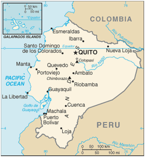
Figure 1.
Map of Ecuador available online: https://www.worldometers.info/img/maps_c/EC-map.gif (accessed on 16 August 2021).
The qualitative methodology involves observing a phenomenon, which is considered a contemporary practice, where the boundaries between the phenomenon and the environment are not clear [17]. In our research, the boundaries between the phenomenon of fit-for-purpose land administration and the environment are not clear, therefore we are observing fit-for-purpose land administration as a contemporary practice. Article [18] elaborates a case study approach to research, empirically investigating a contemporary phenomenon in the real-life context to understand precipitating such a phenomenon.
In order to apply the qualitative methodology to gain an in-depth understanding of fit-for-purpose land administration, this research is based both on the literature review and on primary and secondary data sources. The latter were collected during one-week data collection activities and write shops at the end of 2017 in Quito, Ecuador. Primary data were collected during the interviews and focused group discussions via expert consultation. A semi-structured interview form was used consisting of three topics, namely the frameworks of the fit-for-purpose land administration concept: spatial, legal and institutional frameworks. In continuation, detailed questions/discussions were developed regarding the twelve principles, as presented in Table 1, which provided a solid base for doing the assessment of the land administration in Ecuador. Secondary data were collected from governmental organizations at ministerial and municipal levels. Using qualitative methodology, we collect data that is more in a descriptive data manner rather than statistical.
During the one-week data collection activities, firstly the fit-for-purpose land administration concept was presented and then interviews were performed using the expert consultation method with 16 land professionals. Focused group discussions were applied during the study visits to the two ministries. Additional stakeholders were invited for interviews, but they were not available during the week of data collection. Table 2 presents an overview of the number of experts consulted during the data collection activities.
Table 2.
An overview of consulted number of experts during the research.
Data verification from the interviews and expert consultations was implemented using the write shop approach, where participants from the MIDUVI, MAG, and municipal cadastral office of the capital city Quito drafted 3–4 page documents about their organization’s performance. The documents are in the structure of the basic concept of fit-for-purpose land administration with the three frameworks and can be received on request from the authors. Collecting data and storing it in the structure of the fit-for-purpose basic concept was done so with the intention of having a comprehensive set of required data and information about land information in Ecuador for the coming assessment and analyses. Assessment and analyses of the data were conducted via discussions where results were discussed against the fit-for-purpose frameworks using the same structure of the three frameworks and twelve principles for better interpretation (in Section 5 of this paper). A qualitative methodology based on literature review, interviews, and focus group discussions for data collection, data verification via a write shop, and a score table as a tool was successfully implemented for the case of Ecuador and this could be repeated as a method for other cases when performing similar assessment studies.
After the interviews and the write shop for data collection, two workshops were implemented in Ecuador under the School for Land Administration Studies (a joint initiative with the Netherlands Kadaster International and Faculty ITC, University of Twente). The first workshop was implemented in Ecuador on a national level and included 36 participants on the topic of the introduction of the fit-for-purpose land administration approach at the University of Armed Forces ESPE, Sangolquí, at the end of 2017. In 2018, the second international workshop, with approximately 80 participants from seven Latin American countries and two countries from Europe, dealt with the topic of fit-for-purpose land administration and LADM+ and was performed at the Instituto Geografico Militar in Quito. Further planned activities piloting fit-for-purpose land administration in several locations and presenting results to the authorities in Ecuador have been impacted by the COVID-19 pandemic and postponed.
Findings from this research are presented as results in the next section under the structure of the headings of the three fit-for-purpose frameworks with a link to the source.
4. Results: Land Administration in the Case of Ecuador
This section presents the results of this study based on expert consultation with land professionals during the interviews and focused group discussions. It follows the subsection structure of the three frameworks of fit-for-purpose land administration, and within the subsections, firstly national then urban and finally rural land administration are elaborated. This writing logic was adopted because first land registration is done differently and by different actors for urban and rural areas, focusing on details that can be related to the four principles within each framework.
4.1. Institutional Framework
On the national level, land administration in Ecuador is a state function that is performed by municipalities. Since 1940s, municipalities have been responsible for implementing and maintaining land administration, and the land administration system was designed mainly to support the processes of valuation and property tax collection by municipalities. The majority of municipalities depend on this tax collection, which represents, in many cases, up to 80% of their budget. Within the municipalities there are three land-administration-related data sets: (1) property tax records, (2) cadaster with map representation, and (3) records of owners (persons and legal entities). In half of the municipalities, these three data sets are not properly linked and they perform like isolated islands.
All municipalities in Ecuador maintain and manage the data from their textual and numeric dataset for land administration in their urban areas, commonly known as the urban cadaster. Since 2011, the Ecuadorian Development Bank has financially supported municipalities to establish their cadasters. This support is via financing projects that are unified and established using the same standards and the georeferenced methodology. Following this methodology, appropriate linked spatial and alphanumeric datasets are created. Data collection and maintenance for urban cadaster are elaborated in detail in the National Technical Standards for the Cadaster of Urban-Rural Real Estate and Property Appraisals [19] prepared and published by the MIDUVI.
Land administration in rural areas or the so-called “rural cadaster” was not the focus of attention of the Ecuadorian government and municipalities for a long time; this accumulated many challenges for its administration. Therefore, the project “National System of Information and Management of Rural Lands and Technological Infrastructure” (SIGTIERRAS) was developed and implemented by the MAG (2011–2015). The Ecuadorian Government received a loan of 10 million US dollars from the International Development Bank for completing the project. The aim of SIGTIERRAS was an implementation of an efficient system of rural land administration and management. As a long-term vision, the system was designed to support: “updating the cadaster, providing legal security to property rights, supporting legalization and regularization of land tenure, applying fair and equitable tax policies, and providing information for the planning and territorial organization of the rural area” – based on the focus group discussion with SIGTERRAS personal. In the project period, 47 municipalities were completed with the establishment of a rural cadaster representing 25% of the rural area of the country. In the period before 2010, sporadic parcel registration was possible in municipal offices for the rural areas, and it can be derived that systematic land registration started with the project in 2011. SIGTIERRAS was created to generate land information in an appropriate information system for land administration and management. In the process of creation, a collaboration was established between many related actors responsible for standardization and metadata, and as beneficiaries of the system and the data collected and processed. Actors dealing with standards and metadata are the Military Geographic Institute, Ecuadorian Space Institute, National Secretariat of Planning, and National Council of Geomatics. Beneficiaries of the information system and the data created are municipalities of local self-government, the MAG, the MIDUVI and the SOT. Organization and management of the project, including fieldwork for data collection, was performed by the specialized Executing Unit of the MAG.
4.2. Legal Framework
Observing the legal framework on the national level, in 2008 a new constitution was enforced in Ecuador [20]. In the new constitution, there is a part acknowledging the need for the establishment of a national cadaster that would support the service and information provision on a municipal level. The need for the establishment of a national cadaster is based on the evidence from the past that municipalities were creating and maintaining cadasters on their own without unified standards for the whole state. In addition to the new constitution, a presidential decree was issued in 2011 [21] giving guidelines about the national cadaster. From the presidential decree, we extract the following: “the objective of the National System of the Integrated Geo Cadaster of Habitat and Housing is to: (…) register systematically, logically, geo-referenced and ordered, in a comprehensive and integrated database, urban and rural cadasters, which serves as a tool for the formulation of urban and rural development policies”.
From 2016 onward, the MIDUVI has had a major role in the standardization and construction of the national cadastral system. This was manifested via preparing and providing standards on a national level that support municipalities in their establishment of a unified national cadaster. Following the older legal framework in Ecuador, in 2016 the Organic Law of Territorial Land Use and Management, SAN-2016-1196 [22], came into force. According to this law, land administration in Ecuador includes six land tenure types and these are both legally and socially accepted: (1) state property, (2) private property, (3) associative property, (4) cooperative ownership, (5) mixed-ownership, and 6) community property—this tenure type can be registered and titled in favor of communes, communities, groups of people, and nationalities (as explained in article 85 of [22]). In addition, within the same law, gender equity is elaborated. Within this so-called Organic Law, the MIDUVI was appointed as a governing body for the establishment and maintenance of the national cadaster of Ecuador. The performance of the MIDUVI is supported by one more governmental organization: the Superintendence of Territorial Planning (SOT). The SOT was created in 2016 with the authority to work on capacity development, quality control, and, in addition, has a regulatory role for the cadaster in Ecuador for the performance of all municipal cadasters.
The Organic Law of Territorial Land Use and Management [22] in Article 100 established: “The National Registered Integrated Geographical Cadaster must be updated continuously and permanently and will be administered by the governing body of habitat and housing, which will regulate the conformation and functions of the system and will establish standards, protocols, deadlines, and procedures for the collection of cadastral information and valuation of real estate taking into account land classification, land uses, among others.”
For the land administration in the rural areas, land registration was initiated with Ministerial Agreement 160 in 2008 [23], which established the Executing Unit of the MAG for implementation of the project SIGTERRAS. The additional legal framework with regard to rural land registration and administration was addressed in the New Constitution of the Republic of Ecuador in 2008 [20] and the Organic Law [22] under Article 42. Within the law [22] under Article 85 the six land tenure types are addressed and in the same article the achievement of gender equity and registration of vulnerable and indigenous groups with regard to land and property rights are elaborated.
4.3. Spatial Framework
On the national level, two main governmental initiatives were implemented to support the creation of the national cadaster. The first initiative is the project SIGTIERRAS supported and implemented by the MAG, and the second initiative allows the construction of the “urban cadaster” (term used by our local respondents) in 140 municipalities. The second initiative is financially supported by Ecuadorian Development Bank. Both initiatives have their contribution to the generation and increasing the cadastral coverage of the country following the existing regulations.
As for the land administration field data collection, maintenance, and dissemination, Ecuador is employing several methods. Conventional methods for the land survey are followed by collecting many textual attributes during the survey about every single parcel both in urban and rural areas. First registration of land rights and provision of land administration products via public presentation is a lengthy procedure. Rules and regulations for these activities are addressed in several laws and details for their implementation are described in the manuals for the urban [24] and rural [25] cadasters.
For the land administration in urban areas, at the period of the activities for this research, 140 of the 221 municipalities were implementing projects of the georeferenced urban cadaster. Consequently, a cadastral updating is based on the definition of the urban areas of each municipality clearly delineated apart from the rural areas. For these 140 municipalities, the same standards for data collection and mapping procedures are applied following the manual for urban cadastral projects [24]. Regarding the land survey in urban areas, “the guidelines include exhaustive data collection in the field in order to collect data for the first registration of the real estate with a comprehensive level of details needed to form a cadastral map in scale R = 1:1000,” as expressed in the focus group discussion at the MIDUVI.
Looking at other municipalities, 33 municipalities (out of 221) are implementing their own local urban cadasters. These municipal cadasters are following their own standards and systems combined with the spatial component—maps in local coordinate systems. Among the rest, 34 out of 221 municipalities do not have georeferenced urban cadaster systems or areas covered by cadastral maps. During the focused group discussion at the MIDUVI, there was an evident awareness that “this way of performance with non-integrated computer solutions brings, consequently, a lot of overlap and duplication of functions within the data collection, map production, analysis, and provision of cadastral data”.
Observing the numbers of municipalities (140 + 33), our respondents replied that an approximate coverage of the urban cadaster in Ecuador is 70–75%. It remains unclear what is the actual cadastral coverage within these urban cadastral areas having in mind the fact that this activity started with the implementation of the presidential decree in 2011.
For the land administration in the rural areas, in the period 2011–2014 an aerial survey was completed with coverage of 225,448 km2, representing 89% of the territory of Ecuador. The result from the aerial survey was orthophotos on a scale of 1:5000. After their production, orthophotos were used for cadastral land surveying. In addition, the aerial survey produced thematic cartographic maps and a digital terrain model of the country. For cadastral purposes, a massive fieldwork activity engaged hundreds of smaller teams for the fieldwork land survey and administrative data collection. This part of the project required complex logistics, outsourcing, and experts in different areas in order to manage and organize these teams, as well as proper data and maps storing, under present rules and regulations. Several participants in this project, during the interviews, mentioned that the project needed more human engagement than initially planned and it would be unlikely to repeat the similar or larger project in a similar manner. In total, one million parcels were surveyed with fixed boundaries using different land survey equipment (tape surveys, total stations, real-time kinematic (RTK) devices, GNSS, and handheld GPS) and textual data were collected. Regarding textual data, a two-page form was used (see Appendix A source MAG SIGTIERRAS). Around 55–60 textual attributes were collected for every single rural parcel. The form, it appears, was created for the purposes of the tax cadaster. It contained the possibility to enter data in the following parts: general info about the parcel/form, 6 attributes; part (1) parcel key information, 12 attributes; part (2) private person, marital status, and spouse info, 11 attributes, or legal entity, 9 attributes; part (3) legal information about the parcel with title, 16 attributes, and if the parcel was without a title then 13 attributes; part (4) land use type, natural coverage, and ecosystem, 8 attributes. After the period for aerial and land surveying and textual data collection, a public verification procedure was implemented as an interactive and participatory event for legalization of the derived results and provided a map extraction to the owners.
The information system for land administration and management developed with the project was named “SINAT”. After the first land survey, mapping, land registration, and land records verification in practice were completed, and transfer of knowledge, system, and datasets were handed over to the municipalities. From that moment, it is the responsibility of the municipalities to maintain and keep the rural cadaster up to date. At the moment of this research, 54 municipalities were using the SINAT system for their everyday work activities, according to information received during the focused group discussion at the MAG.
In summary, we can see that many land administration activities are happening in Ecuador and the government has an ambitious strategy to implement a national cadaster on the full territory in a short time. First registration in urban and rural was conducted differently by different actors, and when public presentation and verification of the land maps and records was finished, they were transferred to municipalities for further maintenance and dissemination. It is unclear what is the quality control process within municipalities and whether the updates have a centralized backup and national database on the internet for data display and dissemination. In the next section, the results from this section are discussed against the fit-for-purpose frameworks.
5. Discussions
In this section, the analyses of the results have been derived based on discussing the results from this research against the basic concept of fit-for-purpose land administration utilizing the three frameworks. The following discussions intend to perform the assessment of land administration in Ecuador based on the fit-for-purpose approach and derive a score table identifying principles that need to be addressed when implementing the fit-for-purpose approach.
Observing the land administration in Ecuador, it is evident that many land-related activities are happening, various legislations are being developed, and organizations for implementation are appointed and created. Looking at the aim to have a national land administration system and full land administration coverage of the territory of Ecuador in a short period of 4–5 years (Section 2.4), it is very positive that there is a commitment from the highest political level, with the idea to perform this as a project. On the other hand, this goal will only be possible with a fit-for-purpose land administration approach [1] because with the current conventional method of land administration it would take more time than planned. Observing the long-term vision used for the SIGTERRAS projects (in Section 4.1), it can be derived that the government is moving the focus from mainly a tax cadaster toward a legal cadaster.
5.1. Discussion of the Results against the Principles of the Fit-for-Purpose Approach
Regarding the institutional framework, one of the principles is “good land governance rather than bureaucratic barriers” [1]. From the expert consultation, as in Section 4.1, it is clear that there is good collaboration between all actors that are involved in land administration in Ecuador; however, the technical standards and protocols for data sharing and exchange still need improvement for the implementation in practice. For example, the three so-called isolated islands data sets in the municipalities appear not to be integrated and still operate separately. Relating this to the next principle “integrated institutional framework rather than sectorial silos”, it can be derived that this point needs attention and appropriate integration of the mentioned data sets would improve the efficiency and effectiveness of all stakeholders. Another principle is “flexible ICT approach rather than high-end technology solutions”; based on the expert consultation and focused group discussions, see Section 4.1, the overall information system and the database structure of SINAT satisfy the requirements of the current processes. The last principle in the institutional framework is “transparent land information with easy and affordable access for all” [1]. Linking the last principle to the fact that a big number of attributes are collected in the field during the land survey of fixed boundaries (see Appendix A), this leads us to derive that many elements during collection require more expensive creation and maintenance of the database [12]. All these newly suggested fit-for-purpose opportunities would require adequate capacities and resources development (Chapter 11 of [5]).
Concerning the legal framework, the first principle is “a flexible framework designed along the administrative rather than juridical lines” [1]. This principle should be taken into consideration when planning to speed up the registration and maintenance procedures. It is very important to follow the first principle if/when any changes are planned in the current way of implementing land administration in practice, as those should be backed up with appropriate legal background, bylaws or new regulations. The registration and maintenance procedures in Ecuador are proven as massive and time-consuming, as described in Section 4. The second principle, “a continuum of tenure rather than just individual ownership”, can be linked with the law [22], which includes the six legally and socially accepted land tenure types: (1) state property, (2) private property, (3) associative property, (4) cooperative ownership, (5) mixed ownership, and (6) community property. What is missing are some elements of the “continuum of land rights”, e.g., certificates of occupancy. Ensuring gender equity for land and property rights (see Section 4.2) is in line with the fourth principle, “ensuring gender equity for land and property rights” [1]. Looking at the third principle “flexible recordation rather than one register”, this is already present in Ecuador with land administration in urban (Section 4.2) and in rural (Section 4.2) areas, and maintenance of the three data sets addressed in Section 4.2. Observing the four principles of the legal framework in the context of the Ecuadorian case, we can derive that the first principle needs the most attention.
With regard to the spatial framework, one of the principles is “visible (physical) boundaries rather than fixed boundaries” [1]. This principle is in the opposite situation for the case of Ecuador because according to the current rules and regulations a method of fixed boundaries is mandatory. This is supported with the statement “…including exhaustive data collection in the field” as expressed during the expert consultation and focus group discussions in the MIDUVI in Section 4.3. The next principle of the fit-for-purpose land administration approach is “aerial/satellite imagery rather than field surveys”, again an opposite situation in the case of Ecuador where a field survey is mandatory (as described in both urban and rural areas in Section 4.3). However, it is positive as it is mentioned and demonstrated that orthophotos are used in many ways by multiple stakeholders. The third principle in the spatial framework is “accuracy related to the purpose rather than technical standards”. With the regard to the third principle, we can relate to the statement “…comprehensive level of detail… “in Section 4.3 and usage of different land survey equipment in Section 4.3, and can conclude that it is not a case in Ecuador; especially for collection of textual data the rural areas as in Appendix A. The fourth principle of the spatial framework is “demand for updating and opportunities for upgrading and ongoing improvement” [1]. From the expert consultation, there is an impression that Ecuador is still in the phase of finalizing the full coverage with land administration, where the demand for updating is in the next steps of implementation. This is partly because this activity is a mandate of the municipal cadaster offices, and they have their own resources and quality control mechanisms. During the expert consultation and the write shop with representatives from the MIDUVI and SOT regarding this fourth principle, there was an opinion that this area needs improvement and should be addressed in the near future.
This research found out that one million parcels have been completed in the rural cadaster in Ecuador in a period of 5 years. This was part of a bigger national mapping project, SIGTERRAS, representing 25% of the rural territory (see Section 4.3). These one million parcels in Ecuador are precisely measured with fixed boundaries and linked with around 55–60 text attributes per parcel. It appears that for this project the same rules and regulations as for the urban cadaster were considered. The following question regard these findings: what is the rationale/purpose behind measuring precisely fixed boundaries in rural areas and collecting such a number of attributes? We can derive that a political decision is needed and rethinking of the purpose when the rest of the approximately three million rural parcels are planned to be registered and mapped in a short period of time. Secondly, this could be linked with the multiplier effect: if many attributes are collected, then many attributes have to be stored and maintained [12]; this has a strong implication on the costs and time. Thirdly, based on the SIGTERRAS project description in 4.3, complex logistics, outsourcing, and experts in different areas were required to manage, organize, and administer the work of hundreds of teams; from here we can derive that there is an estimation of a lack of human resources, especially if a national land administration is planned to be implemented by the MIDUVI. Fourthly, as some of the principles are in alignment with the land administration in Ecuador, an adaptation of other principles of fit-for-purpose land administration could be applied. In the results and discussions, the precise measurement of fixed boundaries and a large number of text attributes are considered not in alignment with for-for-purpose principles; it can be derived that interventions could be possible in that regard. An internal MIDUVI assessment on the need and effective use of the precise maps and attributes can determine where these interventions best fit. Our assessment suggests interventions with reducing a number of attributes regarding personal data, legal data, and land use type, and alternative use of imagery.
Additional piloting of the fit-for-purpose approach in several regions in Ecuador to support the suggested interventions was planned under the umbrella cooperation of ESPE University and the School for Land Administration Studies, but because of the COVID-19 outbreak, this was postponed. When presenting the fit-for-purpose land administration concept during the focus group discussions in the MIDUVI (4.1), this concept was discussed further as one of the ways for future implementation of their ambitious aim to have a national cadaster on the full territory in a short time period.
5.2. Score Table for Fit-for-Purpose Land Administration for Ecuador
In continuation, we present a score table for fit-for-purpose land administration for Ecuador based on our assessment and discussions. Because of the qualitative nature of the research, we chose the following scores: H—high level of alignment, M—medium level of alignment, and L—low level of alignment of the results from Ecuador with the principles. The criteria used to apply an appropriate score to the appropriate principles was based on the discussions section where results from the Ecuador case were discussed against the principles of the fit-for-purpose approach. This score table (Table 3) identifies principles that should be addressed if rapid mapping and land registration are desired by the government of Ecuador to be implemented on the whole territory in a short time period. Here follows a fit-for-purpose land administration score table for Ecuador:
Table 3.
A score table based on the assessment of the fit-for-purpose land administration for Ecuador.
From the score table, we can identify which principles are with a low and medium level of alignment with the fit-for-purpose land administration principles as stated in [1].
These could be leading indicators for the Ecuadorian government for areas that need attention when a plan is developed to address rapid mapping and land registration on the whole territory in a short time period. This should be followed with an appropriate strategy for capacity development, available resources, and following the country implementation guide as in [2].
6. Conclusions and Recommendations
The objective of this paper was the assessment of land administration in Ecuador based on the fit-for-purpose approach as an assessment framework. The research was based on a literature review and expert consultation during the data collection activities of primary and secondary data, via interviews and focused group discussions. The analyses of the results and discussions are based on discussing the results against the basic concepts of fit-for-purpose land administration in the structure of the three frameworks and a score table.
We can conclude that Ecuador has established a cadaster in urban areas with approximate 70–75% of municipalities and finished 25% of the area of the rural cadaster. If Ecuador continues at the same pace and speed, it will take many years to finish its full land administration coverage. Land administration in Ecuador is assessed in this paper using the fit-for-purpose land administration approach. This assessment resulted in detailed discussions and a score table. From the score table, we identified principles with a low and medium level of alignment with the land administration in Ecuador. The identified principles are within the spatial and institutional frameworks.
The Ecuadorian government has an ambitious strategy to implement a national cadaster on the full territory in a short period of time and move the focus from mainly a tax cadaster to a legal or fit-for-purpose land administration. Based on our assessment, an adaptation of some of the principles of fit-for-purpose land administration could be utilized. We recommend that identified principles in our score table (with a low and medium alignment) need to be addressed and adopted to the fit-for-purpose approach; specifically with interventions in the precise measurement of fixed boundaries and a large number of text attributes collected in rural areas. For this, an appropriate strategy for implementation should be adopted (as described in [2]) and available resources secured. For the land administration in rural areas, we recommend downsizing the number of attributes collected during the field survey (with reducing of the number of attributes regarding personal data, legal data, and land use type) and alternative use of imagery. Implementing land administration with these interventions would speed up the land administration mapping and land registration in Ecuador.
Author Contributions
Conceptualization, D.T.; Data curation, D.T. and R.S.; Formal analysis, D.T.; Methodology, D.T.; Project administration, D.T. and R.S.; Supervision, D.T.; Writing—original draft, D.T., R.S. and G.J.; Writing—review & editing, D.T., R.S. and G.J. All authors have read and agreed to the published version of the manuscript.
Funding
The funding of the publication costs for this article were kindly provided by the School of Land Administration Studies, Faculty ITC from the University of Twente, in combination with Kadaster International, The Netherlands.
Acknowledgments
The authors would like to express gratitude to the land professionals from Ecuador that provided time and valuable responses during interviews and focus group discussions. Land professionals were from the Ministry for Housing, Ministry of Agriculture, and municipal cadastral office of the capital city of Ecuador, Quito, one municipality which was affected by the 2016 earthquake and University ESPE. The authors would also like to thank anonymous reviewers for their helpful comments, which significantly improved the paper quality.
Conflicts of Interest
The authors declare no conflict of interest.
Appendix A
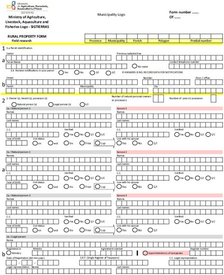
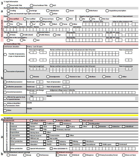
Figure A1.
Fieldwork form for rural land survey textual data collection. Source: SIGTERRAS—secondary data collected during fieldwork.
References
- Enemark, S.; Bell, K.C.; McLaren, R.; Lemmen, C. Fit-for-Purpose Land Administration; FIG Publication No. 60. International Federation of Surveyors and the World Bank. 2014. Available online: https://www.fig.net/resources/publications/figpub/pub60/Figpub60.pdf (accessed on 14 January 2021).
- Enemark, S.; McLaren, R.; Lemmen, C. Fit-for-Purpose Land Administration: Guiding Principles for Country Implementation; UNHABITAT: Nairobi, Kenya, 2016; Available online: https://gltn.net/download/fit-for-purpose-land-administration-guiding-principles-for-country-implementation/ (accessed on 8 December 2020).
- Land Administration Guidelines; UNECE: New York, NY, USA; Geneva, Switzerland, 1996; Available online: http://www.unece.org/fileadmin/DAM/hlm/documents/Publications/land.administration.guidelines.e.pdf (accessed on 7 December 2020).
- Dale, P.; McLaughlin, J. Land Administration; Oxford University Press: Oxford, UK, 1999. [Google Scholar]
- Williamson, I.; Enemark, S.; Wallace, J.; Rajabifard, A. Land Administration for Sustainable Development; ESRI Press: Redlands, CA, USA, 2010. [Google Scholar]
- www.unhabitat.org. Framework for Evaluating Continuum of Land Rights Scenarios; Securing Land and Property Rights for All; UNHABITAT: Nairobi, Kenya, 2016; Available online: https://unhabitat.org/sites/default/files/download-manager-files/Framework%20for%20Evaluating%20Continuum%20of%20Land%20Rights%20Scenarios_English_2016.pdf (accessed on 19 May 2021).
- Zevenbergen, J.; Augustinus, C.; Antonio, D. Designing a Land Records System for the Poor; UNHABITAT: Nairobi, Kenya, 2012; Available online: https://unhabitat.org/designing-a-land-records-system-for-the-poor-secure-land-and-property-rights-for-all (accessed on 7 December 2020).
- Voluntary Guidelines on the Responsible Governance of Tenure of Land, Fisheries and Forests in the Context of National Food Security; FAO: Rome, Italy, 2012; Available online: http://www.fao.org/3/a-i2801e.pdf (accessed on 7 December 2020).
- Land Governance Assessment Framework; World Bank: Washington, DC, USA, 2015; Available online: https://www.worldbank.org/en/programs/land-governance-assessment-framework (accessed on 7 December 2020).
- UN-GGIM. Framework for Effective Land Administration (p. 30). p. 30. Available online: https://ggim.un.org/meetings/GGIM-committee/9th-Session/documents/E_C.20_2020_10_Add_1_LAM_background.pdf (accessed on 23 April 2021).
- Zevenbergen, J.; de Vries, W.; Bennett, R. (Eds.) Advances in Responsible Land Administration; CRC Press (Tylor and Francis Group): Boca Raton, FL, USA, 2016. [Google Scholar]
- Lemmen, C. A Domain Model for Land Administration. Ph.D. Thesis, Technical University Delft, Delft, The Netherlands, 5 July 2012. [Google Scholar]
- Enemark, S.; McLaren, R. Making FFP Land Administration Compelling and Work in Practice. In Proceedings of the FIG Commission 7 International Commission 7 2018 International Seminar, Bergen, Norway, 24–28 September 2018. [Google Scholar]
- Ho, S.; Choudhury, P.R.; Haran, N.; Leshinsky, R. Decentralization as a Strategy to Scale Fit-for-Purpose Land Administration: An Indian Perspective on Institutional Challenges. Land 2021, 10, 199. [Google Scholar] [CrossRef]
- Molendijk, M.; Morales, J.; Lemmen, C. Light Mobile Collection Tools for Land Administration; Proof of Concept for Colombia. GIM International, Online Magazine. 2015. Available online: https://www.gim-international.com/content/article/light-mobile-collection-tools-for-land-administration (accessed on 4 February 2021).
- Todorovski, D.; Salazar, R.; Jacome, G.; Bermeo, A.; Orellana, E.; Zambrano, F.; Teran, A.; Mejia, R. Land Administration in Ecuador; Current Situation and Opportunities with Adoption of Fit-for-Purpose Land Administration Approach. In Proceedings of the World Bank Conference on Land and Poverty 2018: Land Governance in an Interconnected World, Washington, DC, USA, 19–23 March 2018. [Google Scholar]
- Thomas, R.M. Blending Qualitative and Quantitative Research Methods in Theses and Dissertations; Corwin Press: Thousand Oaks, CA, USA, 2003. [Google Scholar]
- Yin, R.K. Case-Study Research–Design and Methods (Vol. 5); Sage Publications: Thousand Oaks, CA, USA, 2003. [Google Scholar]
- Ministerial Agreement No. 029-16, 2016. National Technical Standards for the Cadaster of Urban-Rural Real Estate and Property Appraisals; MIDUVI: Quito, Ecuador, 2016; Available online: https://www.habitatyvivienda.gob.ec/wp-content/uploads/downloads/2016/08/Acuerdo-Ministerial-No-0029-16-Normas-Tecnicas-Nacionales-para-el-Catastro-de-Bienes-Inmuebles-Urbanos-Rurales-y-Avaluos-de-Bienes-Operacion-y-Calculo-de-Tarifas-de-la-Dinac.pdf (accessed on 16 August 2021).
- Constitution of the Republic of Ecuador. 2008. Available online: http://pdba.georgetown.edu/Constitutions/Ecuador/english08.html (accessed on 11 December 2020).
- Presidential Decree, No. 410 for the creation of the National Committee of Cadastre, Quito-Ecuador, Presidency of Ecuador. Available online: https://www.registroficial.gob.ec/index.php/registro-oficial-web/publicaciones/registro-oficial/item/3390-registro-oficial-no-410.html (accessed on 16 August 2021).
- Law 1196. Law for Territorial Ordering and Land use Management. National Parliament of the Republic of Ecuador. 2016. Available online: http://www.habitatyvivienda.gob.ec/wp-content/uploads/downloads/2016/08/Ley-Organica-de-Ordenamiento-Territorial-Uso-y-Gestion-de-Suelo1.pdf (accessed on 11 December 2020).
- Ministerial Agreement 160. Establishment of MAGAP Execution Unit for Implementation National Rural Land Management and Information Program-SIGTIERRAS; MAG: Quito, Ecuador; Available online: http://servicios.agricultura.gob.ec/mag01/pdfs/aministerial/2008/2008_160.pdf (accessed on 16 August 2021).
- Manual Urban, Guidelines for urban cadastral projects Quito-Ecuador, Banco de Desarrollo del Ecuador. 2015. Available online: http://bde.fin.ec/asistencia-tecnica/ (accessed on 15 February 2018).
- Manual for Data Collection for Rural Parcels. Available online: http://www.sigtierras.gob.ec/descargas/ (accessed on 8 December 2020).
Publisher’s Note: MDPI stays neutral with regard to jurisdictional claims in published maps and institutional affiliations. |
© 2021 by the authors. Licensee MDPI, Basel, Switzerland. This article is an open access article distributed under the terms and conditions of the Creative Commons Attribution (CC BY) license (https://creativecommons.org/licenses/by/4.0/).