An IoE and Big Multimedia Data Approach for Urban Transport System Resilience Management in Smart Cities


 ,
,  , , ,
, , ,
Abstract
:1. Introduction
- (a)
- the underspecified nature of operations in complex systems (many adverse events are the result of unexpected combinations of normal performance variabilities [8]) generates potential for unforeseeable failures and cascading effects;
- (b)
- the existence of multiple sub-systems with non-linear and sometimes hidden interactions, requires approaches to cope with “unknown unknowns” that is not always fully understood;
- (c)
- existence of a number of methods and scales of analysis not fully standardized;
- (d)
- multiple stakeholders and institutions which have different worldviews and competing opportunistic goals.
2. Related Work
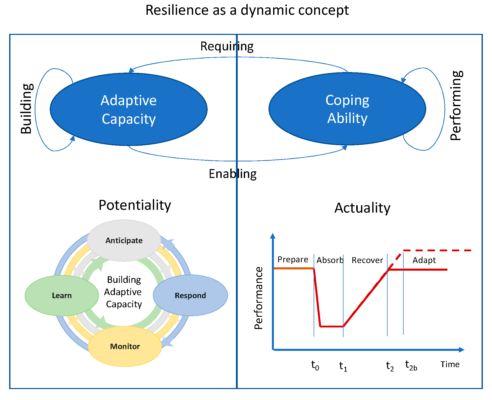
2.1. Resilience
- Respond (knowing what to do): it is related to the capacity of the system, to respond to a stressor by continuously adjusting system performance to changing conditions.
- Monitor (knowing what to look for): it is related to the capacity of the system, to monitor both the system and the context collecting data and information to detect events and reduce the uncertainty.
- Anticipate (knowing what to expect): it is related to the capacity of the system to early identify and evaluate potential threats as well as their consequences for system operation seizing the opportunities for changes offered by the needs of adaptation.
- Learn (knowing what has happened): it is related to the capacity to learn from past experiences either successful or not.
2.2. Smart City and Internet of Everything
- (a)
- People: considered as end-nodes always connected to the Internet and as a source of knowledge, information, decisions, behaviors and so forth.
- (b)
- Things: it ranges from physical sensors and actuators with limited computational capabilities, to smart devices (e.g., smartphones) able to generate and process a relevant amount of data as multimedia resources.
- (c)
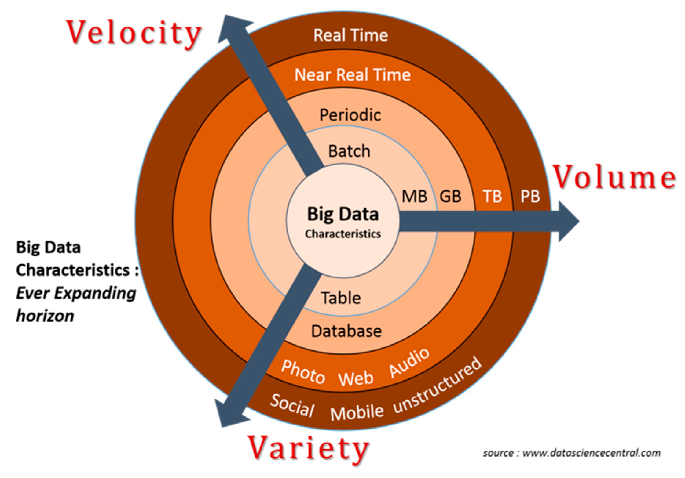
- Big Multimedia Data: huge stream of raw data generated, exchanged analyzed and processed to enable reliable decisions and control mechanisms,
- (d)
- Processes: methodologies and mechanisms for automation to leverage high speed connectivity represented by the 5G (and the future 6G) among data, things, and people to add value.
3. Method
3.1. Towards a Novel Definition of Resilience
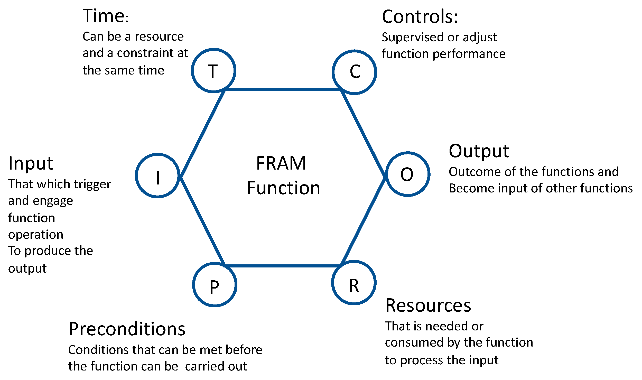
3.2. Functional Resonance Analysis Method
- (a)
- The equivalence of success and failure that emerge from performance variability.
- (b)
- Variability represents the deviation of the performance respect to the expectation.
- (c)
- Emergence of either success or failure is due by the unexpected interaction of variability of different functions.
- (d)
- The unexpected ‘amplified’ effects of interactions between different sources of variability are at the origin of the so-called functional resonance phenomena that leads to a disruption.
3.3. Urban Big Multimedia Data Approach
- Understanding the urban transport system (UTS): use of the FRAM approach in managing critical events
- Understanding what information is needed to take decisions
- Selecting/producing U-BDM: methodologies to be adopted to select and collect the data needed
- U-BDM collection and integration: data collection
- U-BDM sense making, how the data is transformed into information
- Knowledge driven decision: how the information is transformed into knowledge
3.3.1. Understanding the UTS System
3.3.2. Understanding Information Needs
3.3.3. Selecting/Producing U-BMD
3.3.4. U-BMD Collection and Integration
3.3.5. U-BMD Sense-Making
3.3.6. KID Driven Decisions
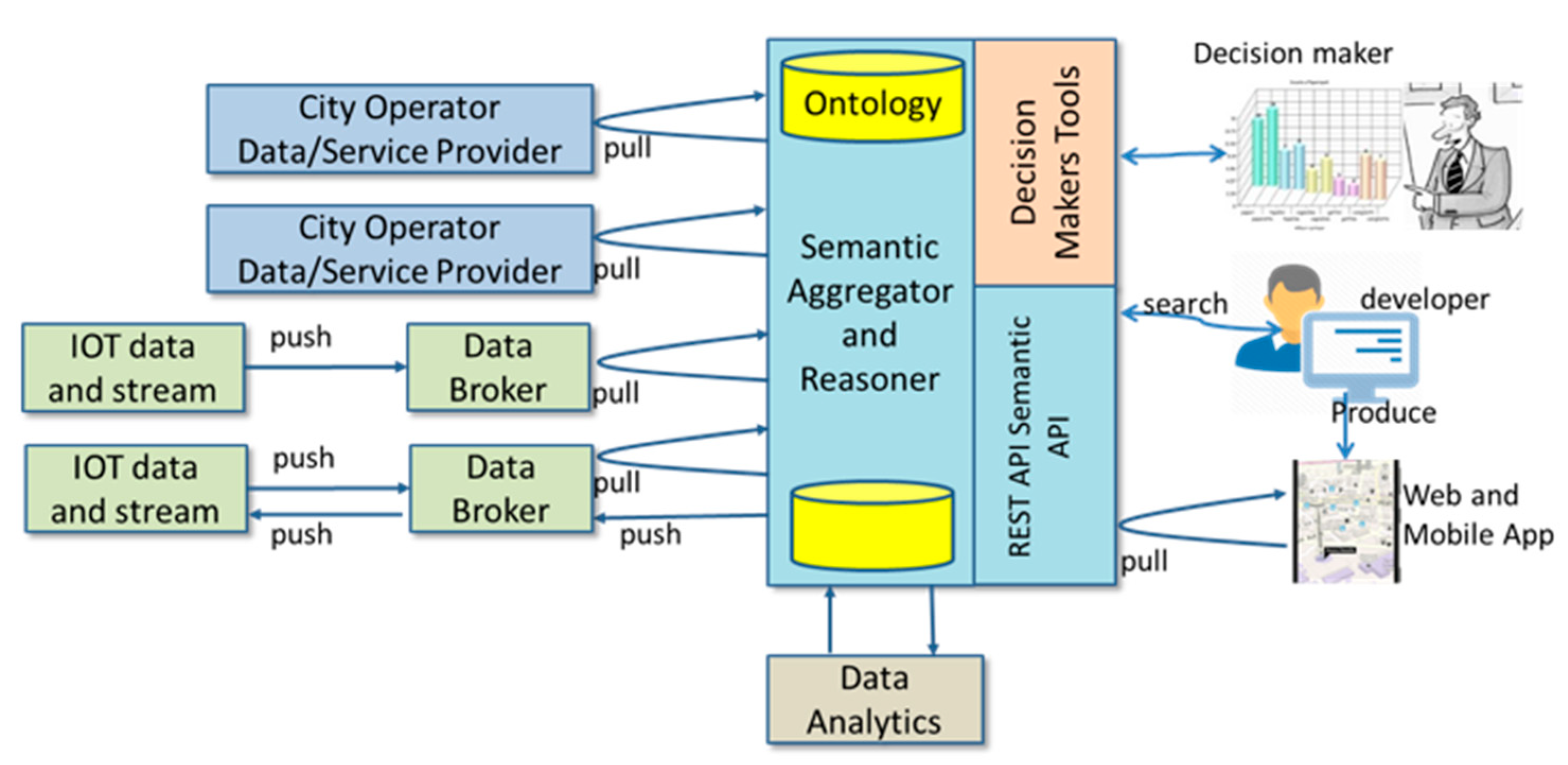
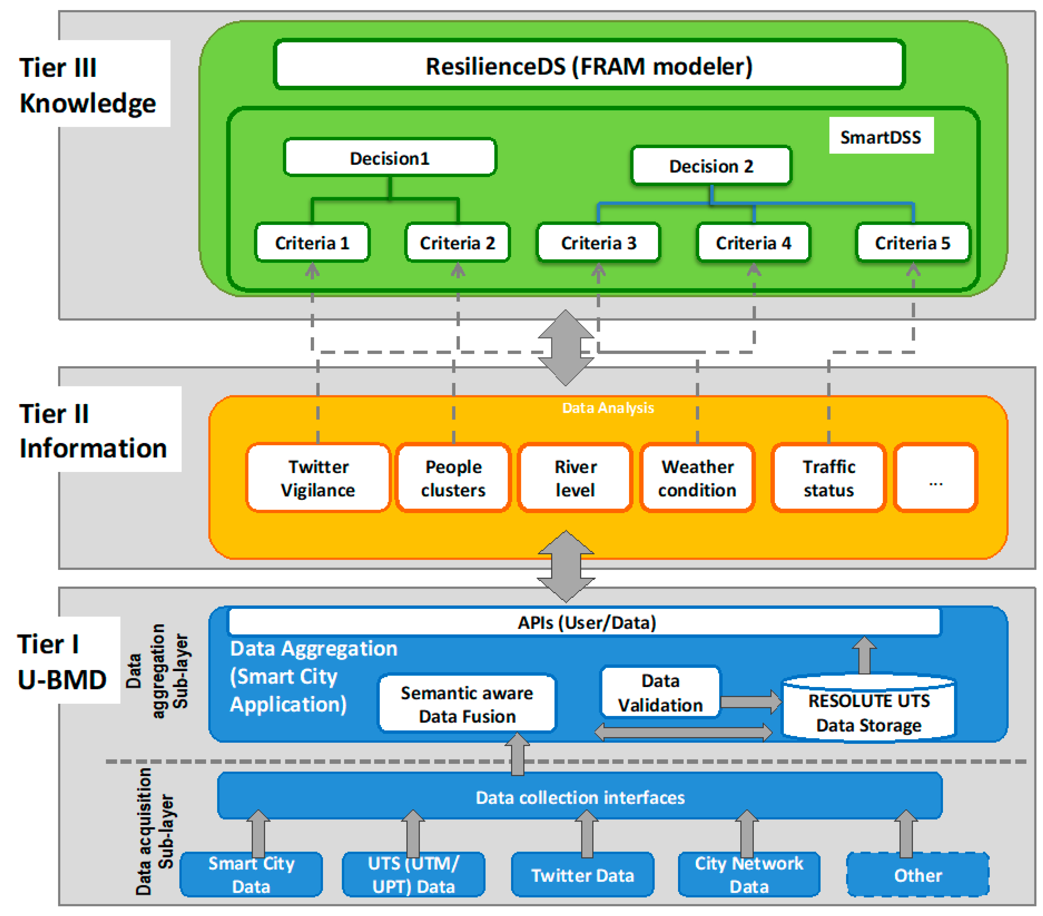
4. U-BMD Architecture
4.1. Tier Architecture
- Tier I—Urban Big Multimedia Data Management
- Tier II—Information (U-BMD Sense Making)
- Tier III—Knowledge (Knowledge Driven Decision Support System)
- (a)
- Anticipate: by continuously assessing city vulnerabilities and identifying when the system operates closer to safety boundaries, predicting behaviors and event dynamics, supporting evidence-based decisions at strategic, tactical, and operational level, thus moving a step forward with respect to current practices based on pre-simulated emergency scenarios.
- (b)
- Respond: by delivering real-time, context-aware, personalized, and ubiquitous advice to the citizens by exploiting IoE technologies
- (c)
- Monitor: by improving the granularity, timelines, precision, quality and comprehensiveness of information about the city metabolism dynamics.
- (d)
- Learn: by applying advanced analysis on U-BMD (e.g., deep learning, data analysis and prediction, sentiment analysis) to extract valuable information and knowledge for decision-making;
4.2. Tier I—Urban Big Multimedia Data Management
4.2.1. Data Acquisition Sub-Layer
- Traffic Manager to track the status of the traffic in the city
- Public Transport schedule plans and real time status;
- Road network status: roads, bridges, underpasses, etc.;
- Parking position and status, car and bike sharing, movements of public vehicles, cycling paths, etc.
4.2.2. Data Aggregation Sub-Layer
4.2.3. Ontology Extension for Dynamic Damage Analysis
- Asset vulnerability: depends on the type of asset, its location, its physical characteristics (materials, design), and so forth;
- Asset value: it depends on its characteristics and functions and it has an economic and/or social value according to the role played in the society;
- Magnitude of the event: the magnitude of the event is calculated through specific Observation collections.
- models instances of rainfall observations received by the related sensors;
- it models instances of ground temperature received by the related sensors;
- it models instances of seismic observations received by the related sensors;
- it models instances of traffic observations received by the related sensors;
- (a)
- PhysicAssetValue used to model economic values/importance for the population related to business/physical asset;
- (b)
- ServiceAssetValue used to model economic values/importance for the population related to the type of service;
- (c)
- SocialAssetValue to model the value and/or the social importance related to asset/service.
- SELECT * WHERE {
- ?v a risk:SeismicVulnerability;
- risk:forAssetType “Service”;
- risk:fromMinIntensity ?min;
- risk:toMaxIntensity ?max;
- gis:hasGeometry/gis:asWKT ?wkt.
- FILTER(?min ≤ 4.5 && 4.5 ≤ ?max)
- ?s a km4c:Service;
- geo:lat ?lt; geo:long ?ln.
- ?s risk:hasAssetValue ?avalue.
- FILTER(st_intersects(st_point(?ln,?lt),?wkt))
- }
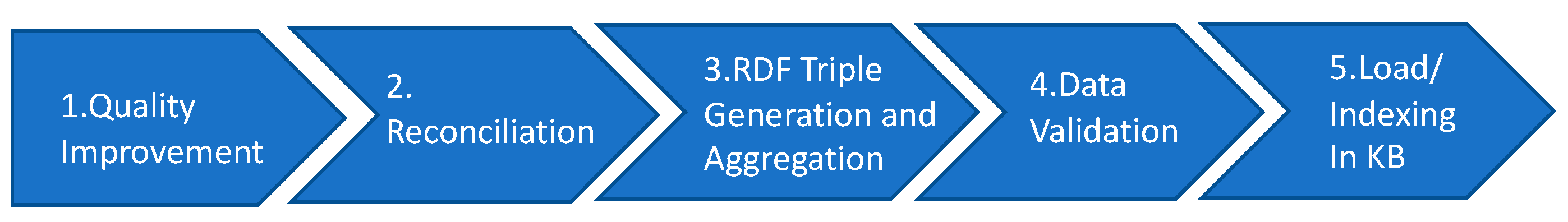
4.2.4. Data Transformation Multi-Steps
4.3. Tier II Information—U-Bmd Sense Making
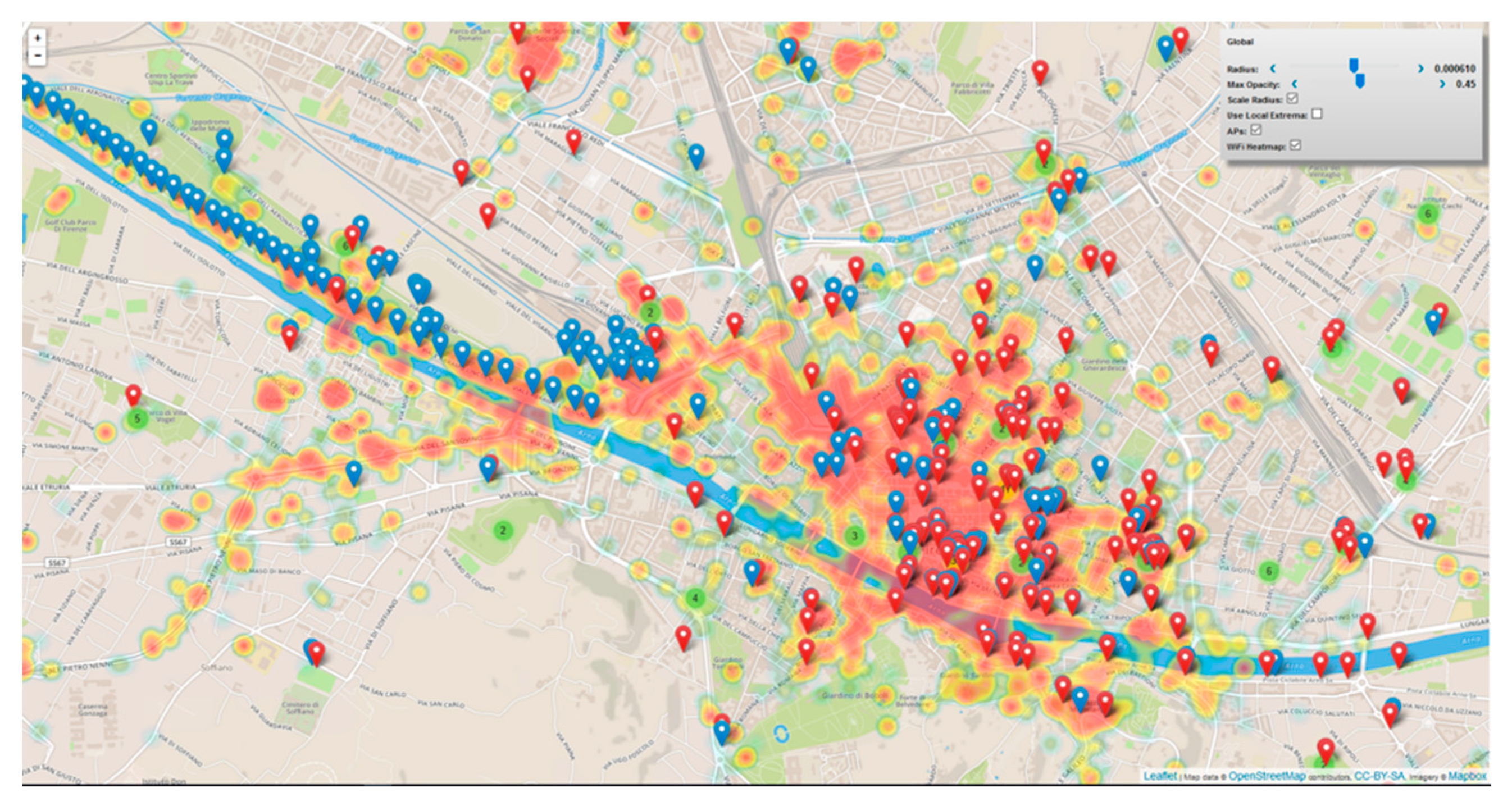
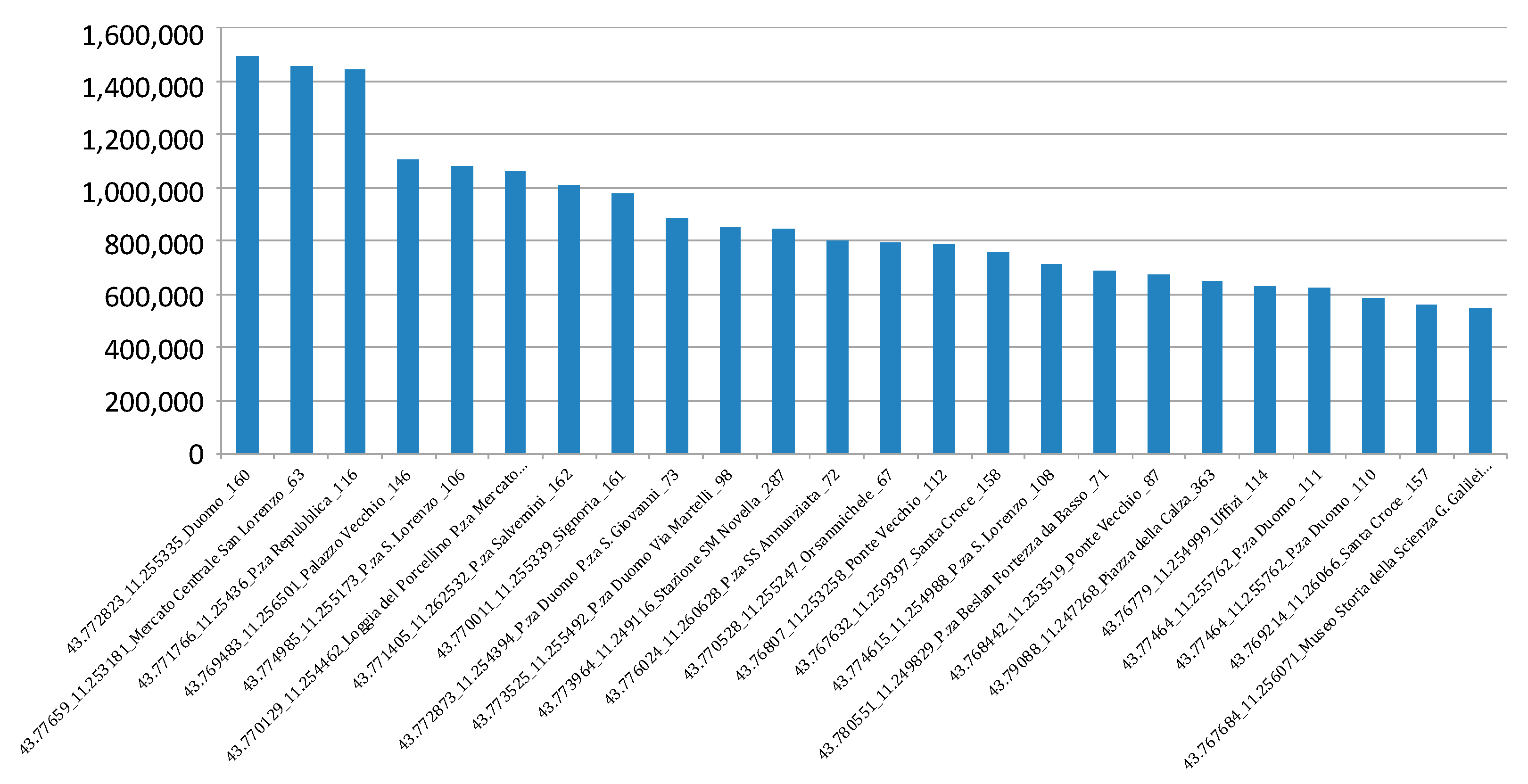
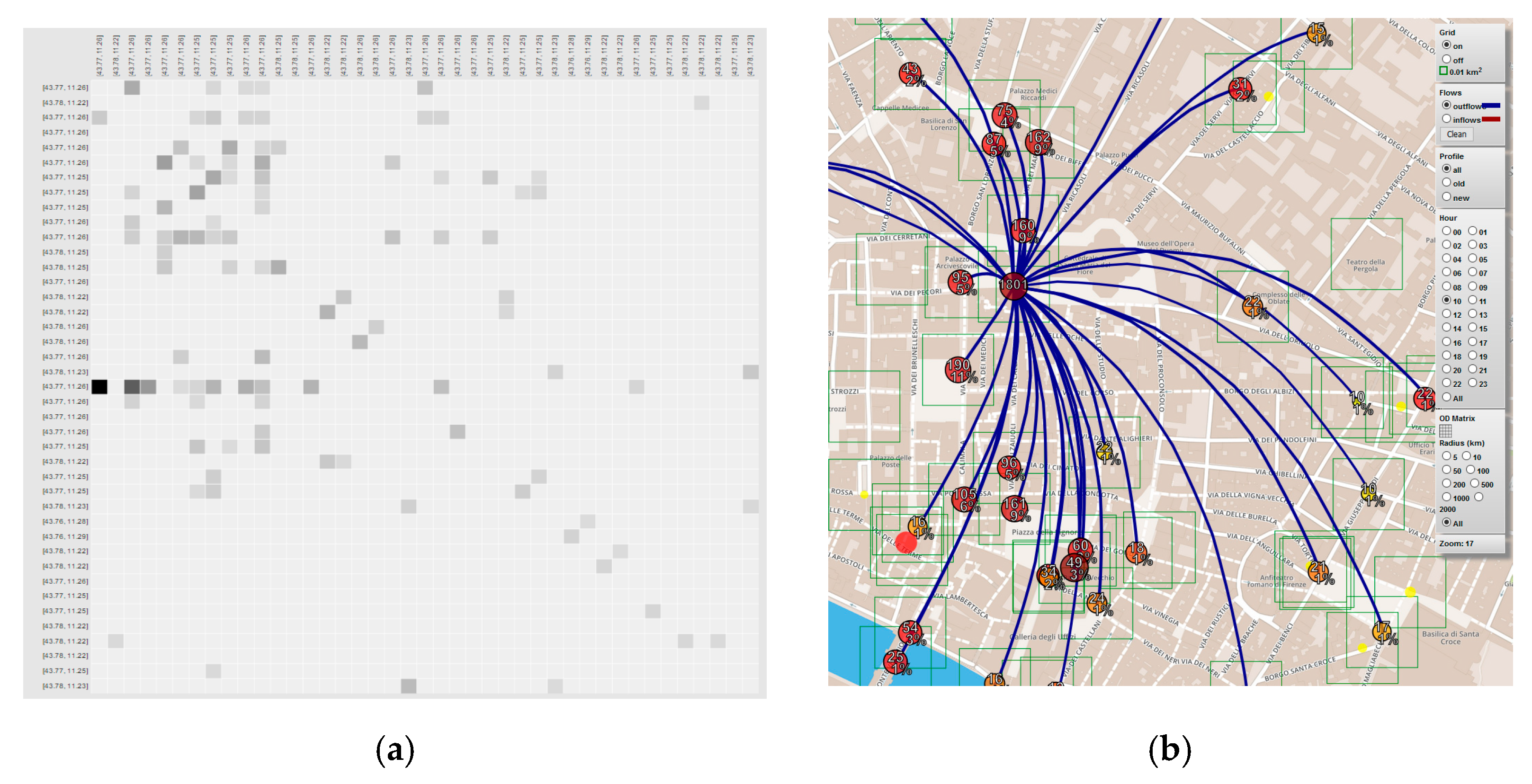
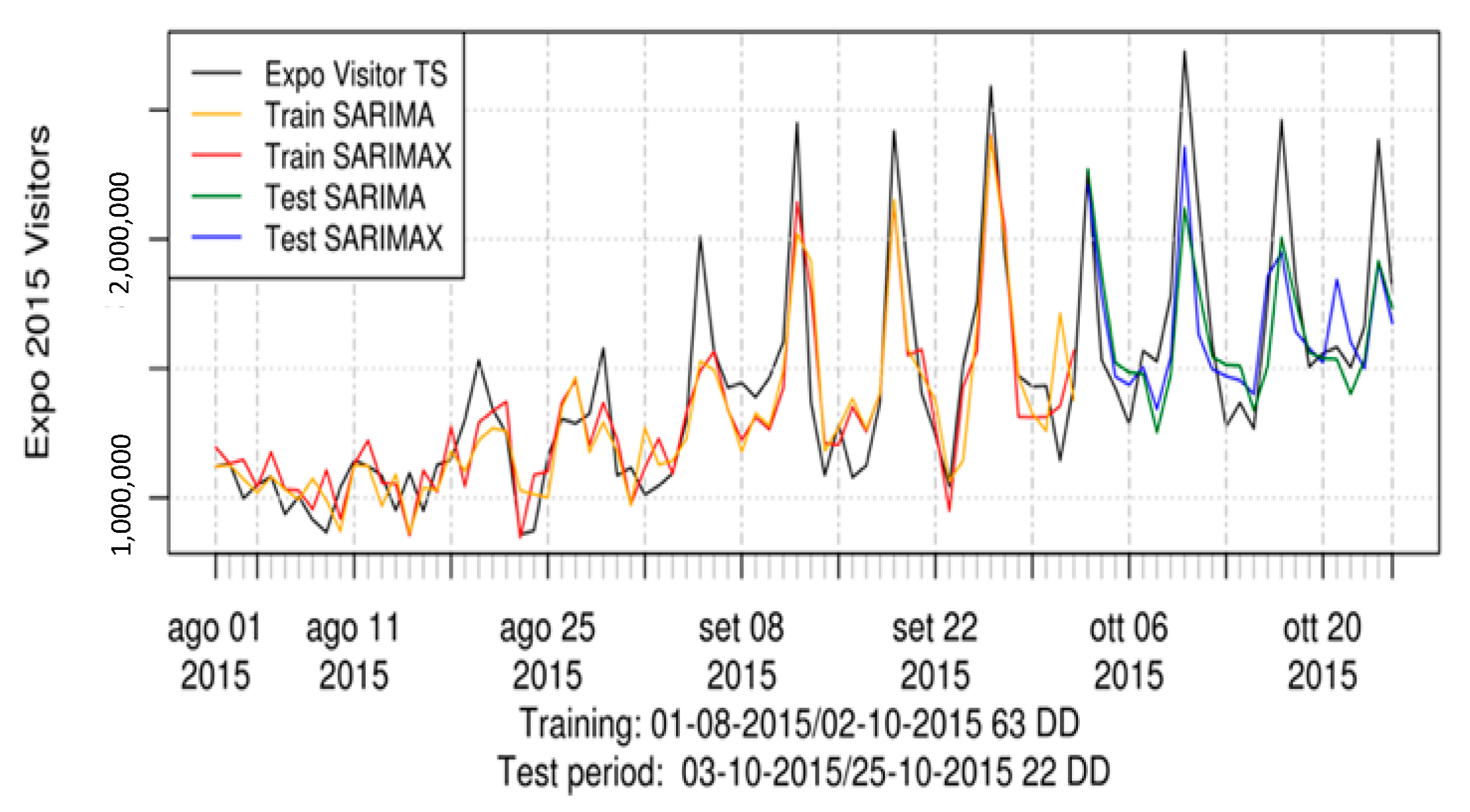
4.3.1. Wi-Fi-Based Human Behavior Analysis Module
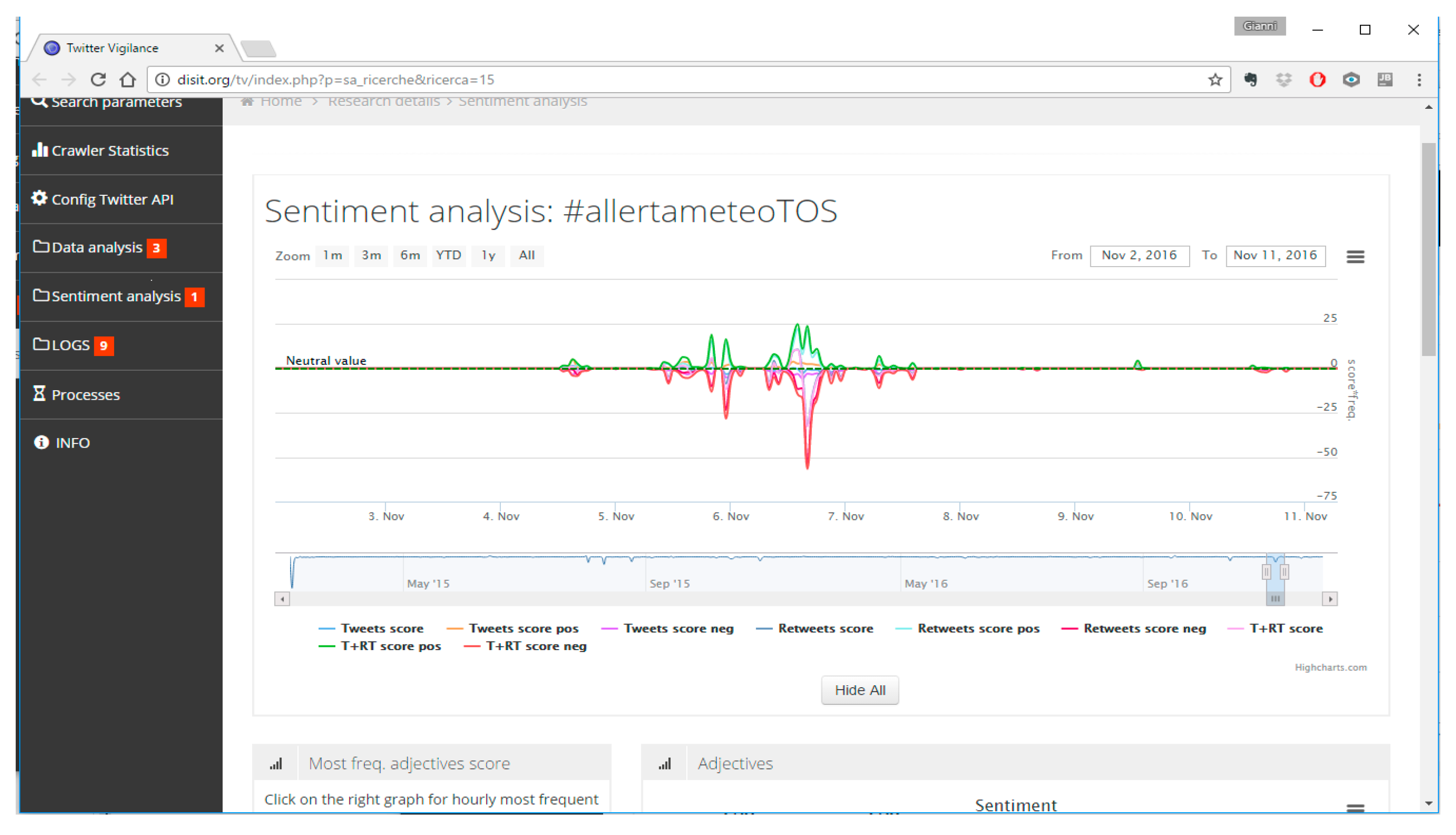
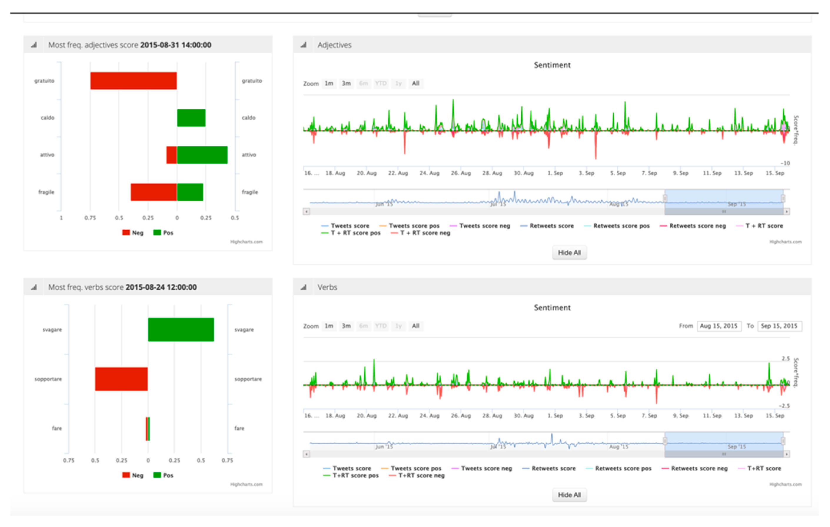
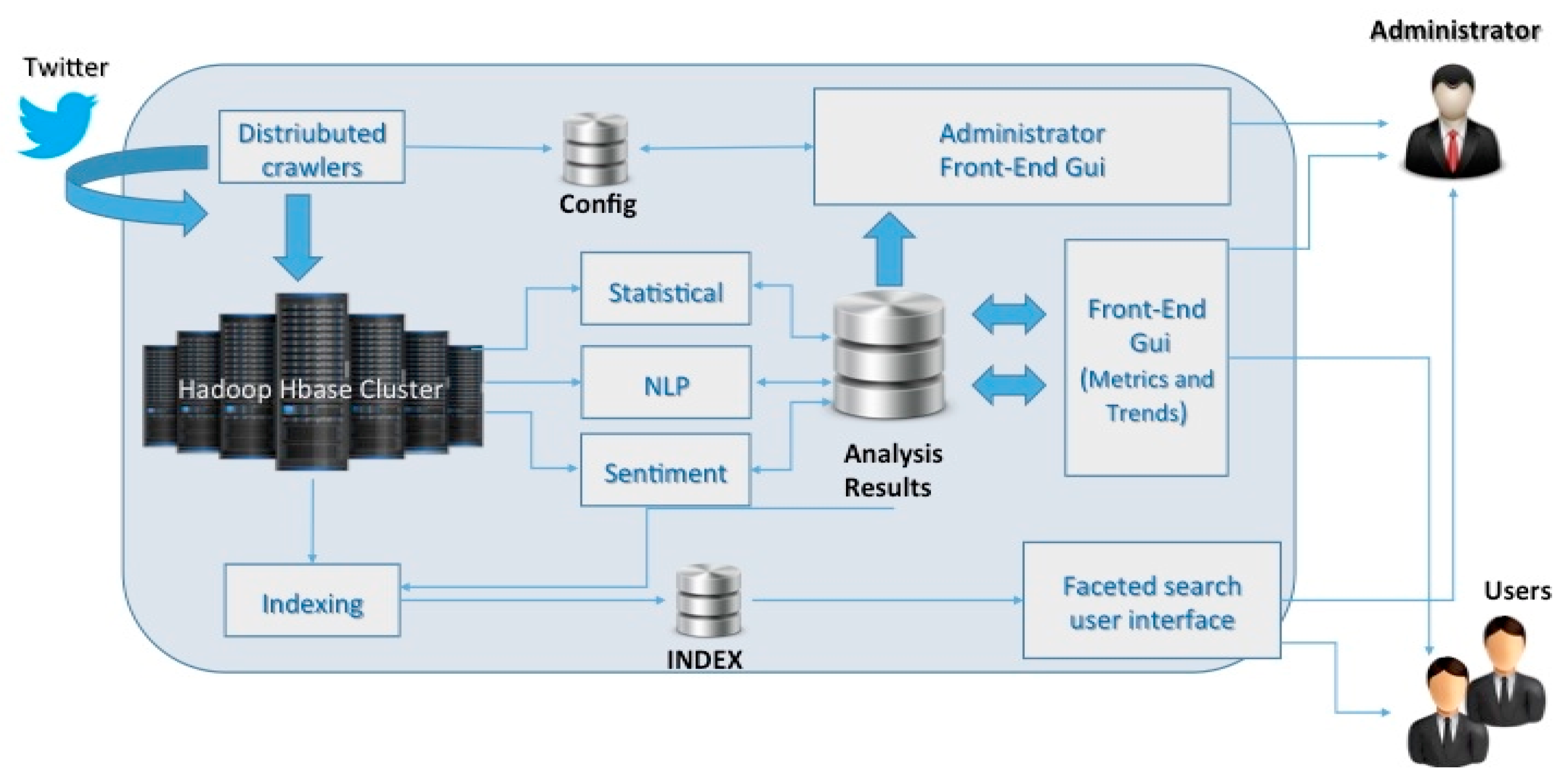
4.3.2. Social Media Analysis: Twitter Vigilance Module
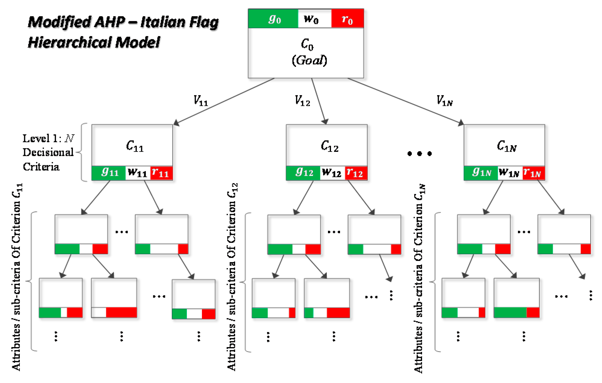
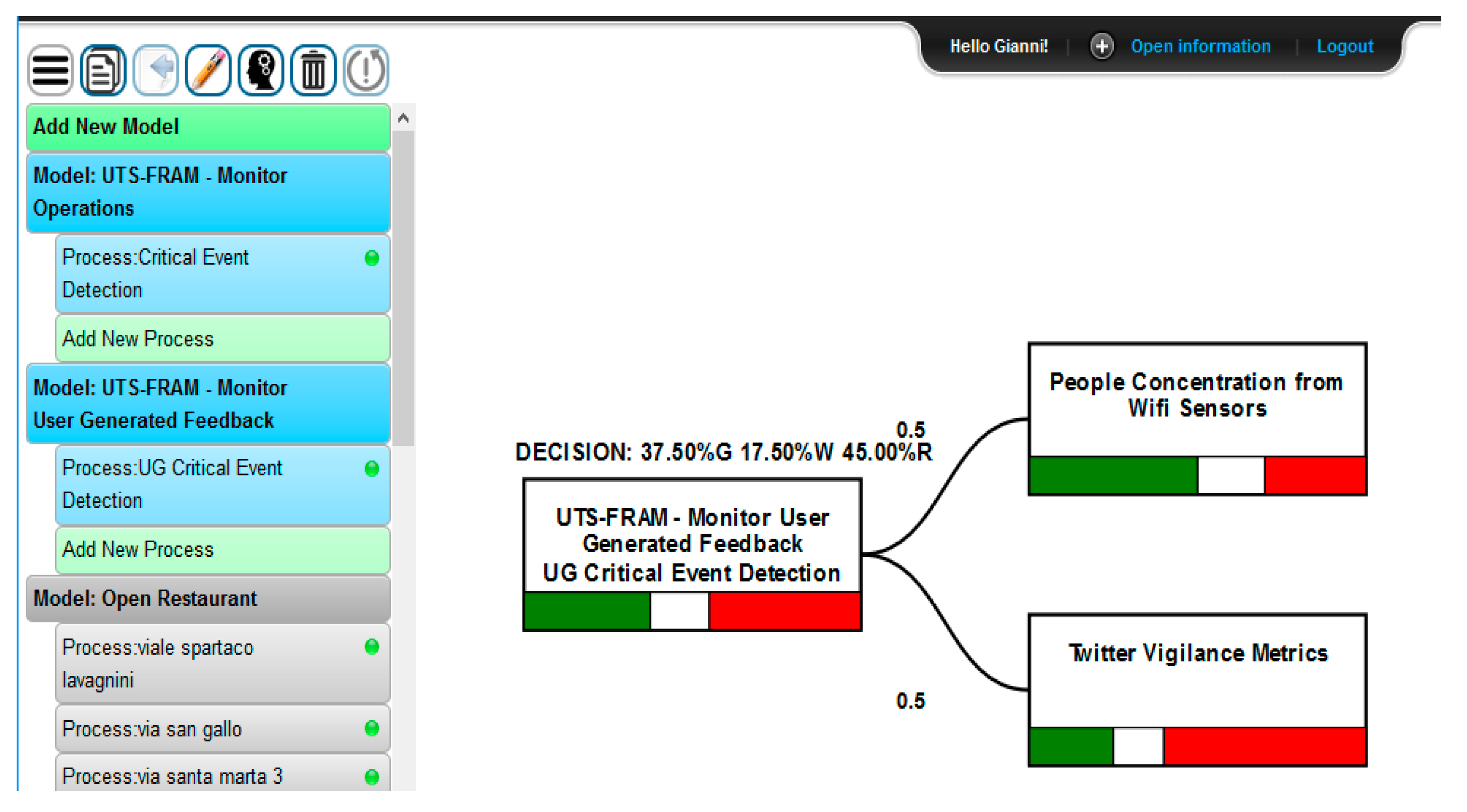
4.4. Tier III—Knowledge-Driven Support System
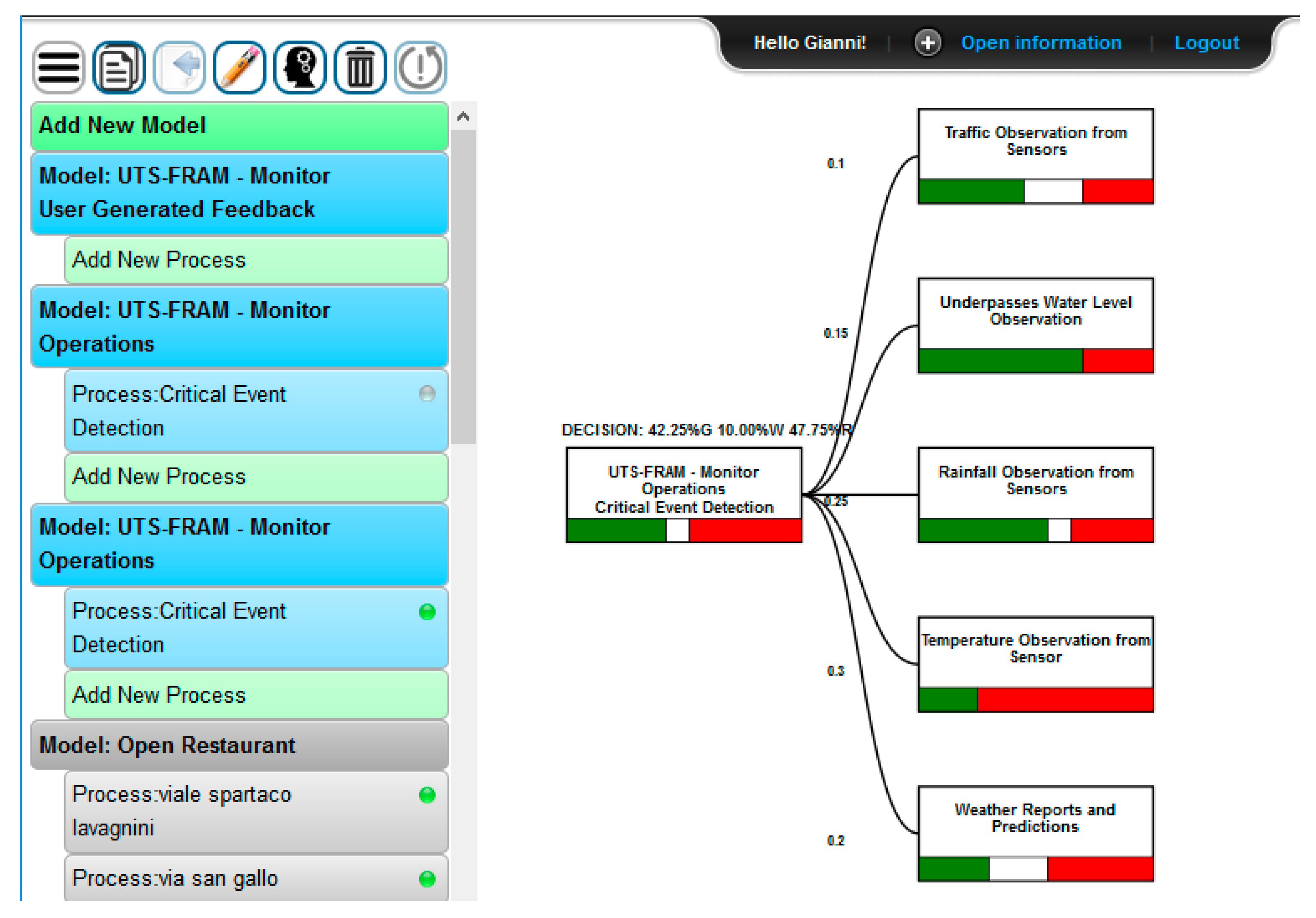
Resilience DS
- (1)
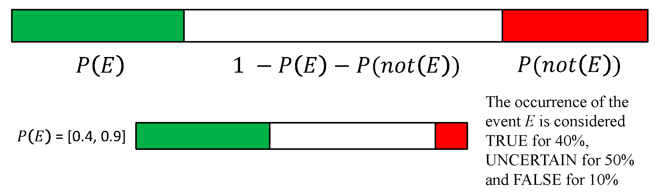
- Data from external sources obtained with HTTP API requests: the tool supports a semantic ware query to an external RDF semantic repository accessing to the SPARQL endpoint URLs and a query to a generic HTTP REST requests and calls to dedicated services/APIs. It is possible to combine up to two queries for each single node and the results are compared to threshold values defined by decision makers.
- (2)
- Data from stakeholders’ opinions and feedbacks. In particular, opinions can be directly mapped to IF values: the value for the green color is obtained from the percentage of favorable opinions, the value for the white color is obtained from to the percentage of uncertainty opinions or answers not provided, and the value for the red color is derived by the percentage of opinions against that criterion/condition.
5. Results
- (a)
- Impossibility to identify exactly the involved areas.
- (b)
- Extreme intensity of rainfall
- (c)
- Abrupt reduction of temperature and visibility
- (d)
- Sudden overflowing of water on roads, underpasses, etc.
- (e)
- Sudden traffic flow reduction
- -
- D1: send an appropriate rescue team in due time (if needed)
- -
- D2: send appropriate street maintenance team in due time (if needed)
- -
- D3: closure of the underpasses in the affected area
- -
- D4: redirection of the incoming traffic towards alternative routes
- -
- D5: provide safety recommendation to people in the affected area considering potential risks (e.g., high water in a specific area because of particular land shaping)
- -
- D6: alert population about status of the event to orient their decisions (e.g., to discourage passage in the area)
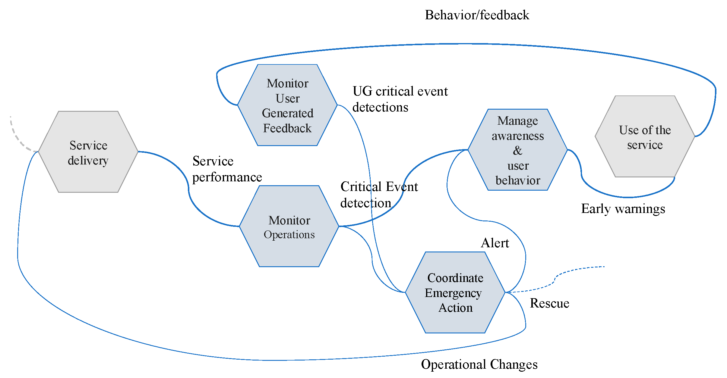
- Output: User-Generated Critical Event Detection
- Output: Critical Event Detection
- Output:
- -
- Rescue (D1,D2)
- -
- Operation Changes (OC) (D3,D4)
- -
- Advices (D5,D6)
- Output: Early Warnings
- Monitor Operations resources:
- -
- Traffic observation from sensors applying user defined thresholds on results to detect traffic flow trends, predictions, and reconstructions;
- -
- Underpasses water level observation: for underpass water level, applying user defined thresholds in order to detect if water exceeds the safe level in a given underpass;
- -
- Rainfall observation from pluviometry sensors at different times, applying user defined thresholds on results to detect if rain level exceeds a safe value;
- -
- Temperature observation from thermometric sensors at different times, applying user defined thresholds on results to detect if temperatures abruptly drop down;
- -
- Weather reports and predictions: related to temperature, dew point, humidity, etc.;
- -
- Pollution reports and predictions: related to environmental sensor data and reports;
- Monitor User Behavior and User Generated Feedback resources:
- -
- People density real time and predictions, established analyzing data coming from the city Wi-Fi sensors and resulting data analytics as previously described;
- -
- Prediction on parking lots collecting data analytic results and thresholding on the basis of their values.
- -
- Twitter Vigilance metrics: collecting volume, natural language processing and sentiment analysis metrics (as well as custom high-level metrics defined by users) about Florence weather related channels.
6. Conclusions
Author Contributions
Funding
Institutional Review Board Statement
Informed Consent Statement
Data Availability Statement
Acknowledgments
Conflicts of Interest
Appendix A
References
- Field, C.B. Managing the Risks of Extreme Events and Disasters to Advance Climate Change Adaptation: Special Report of the Intergovernmental Panel on Climate Change; Cambridge University Press: Cambridge, UK, 2012. [Google Scholar]
- Bellini, E.; Ceravolo, P.; Nesi, P. Quantify Resilience Enhancement of UTS through Exploiting Connected Community and Internet of Everything Emerging Technologies. ACM Trans. Internet Technol. 2017, 18, 1–34. [Google Scholar] [CrossRef]
- Forzieri, G.; Cescatti, A.; e Silva, F.B.; Feyen, L. Increasing risk over time of weather-related hazards to the European population: A data-driven prognostic study. Lancet Planet. Health 2017, 1, e200–e208. [Google Scholar] [CrossRef]
- Leveson, N.G. A new accident model for engineering safer systems. Saf. Sci. 2004, 42, 237–270. [Google Scholar] [CrossRef] [Green Version]
- Caragliu, A.; Del Bo, C.; Nijkamp, P. Smart Cities in Europe. J. Urban Technol. 2011, 18, 65–82. [Google Scholar] [CrossRef]
- Walker, B.; Salt, D. Resilience Thinking: Sustaining Ecosystems and People in a Changing World; Island Press: Washington, DC, USA, 2006. [Google Scholar]
- Bellini, E.; Nesi, P. Exploiting smart technologies to build smart resilient cities. Routledge Handb. Sustain. Resilient Infrastruct. 2018, 685–705. [Google Scholar] [CrossRef]
- Wilson, J.R.; Ryan, B.; Schock, A.; Ferreira, P.; Smith, S.; Pitsopoulos, J. Understanding safety and production risks in rail engineering planning and protection. Ergonomics 2009, 52, 774–790. [Google Scholar] [CrossRef] [PubMed]
- Bellini, E.; Nesi, P.; Coconea, L.; Gaitanidou, E.; Ferreira, P.; Simoes, A.; Candelieri, A. Towards resilience operationalization in urban transport system: The RESOLUTE project approach. In Risk, Reliability and Safety: Innovating Theory and Practice, Proceedings of the 26th European Safety and Reliability Conference, ESREL 2016, Glasgow, Scotland, 25–29 September 2016; Walls, L., Revie, M., Bedford, T., Eds.; Taylor & Francis Group: Glasgow, UK; London Informa UK Limited: London, UK, 2017; pp. 2110–2117. [Google Scholar]
- Cutter, S. The landscape of disaster resilience indicators in the USA. Nat. Hazards 2016, 80, 741–758. [Google Scholar] [CrossRef]
- Batty, M. The Size, Scale, and Shape of Cities. Science 2008, 319, 769–771. [Google Scholar] [CrossRef] [Green Version]
- Hollnagel, E.; Woods, D.D. Epilogue: Resilience Engineering Precepts. In Resilience Engineering; CRC Press: Boca Raton, FL, USA, 2017; pp. 347–358. [Google Scholar]
- National Academy of Sciences. Disaster Resilience: A National Imperative; The National Academies Press: Washington, DC, USA, 2012; Available online: www.nap.edu/catalog.php?record_id=13457 (accessed on 7 January 2021).
- Bellini, E.; Coconea, L.; Nesi, P. A Functional Resonance Analysis Method Driven Resilience Quantification for Socio-Technical Systems. IEEE Syst. J. 2019, 14, 1234–1244. [Google Scholar] [CrossRef]
- Jovanovuc, A. Smart Rsilience—In Aligning the Resilince-Related Research Effort in the EU-DRS Project; Joint Workhsop-DRS-7&14; European Virtual Institute for Integrated Risk Management (EU-VRi): Stuttgart, Germany, 2017. [Google Scholar]
- Flax, L.; Armstrong, A.; Yee, L. Measuring urban resilience as you build it: Insights from 100 resilient cities—Re-silience. In IRGC Resource Guide on Resilience; Florin, M.V., Linkov, I., Eds.; EPFL International Risk Governance Center (IRGC): Lausanne, Switzerland, 2016; Available online: https://beta.irgc.org/wp-content/uploads/2018/09/Flax-Measuring-Urban-Resilience-As-You-Build-It.pdf (accessed on 7 January 2021).
- Meerow, S.; Newell, J.P.; Stults, M. Defining urban resilience: A review. Landsc. Urban Plan. 2016, 147, 38–49. [Google Scholar] [CrossRef]
- Holling, C.S.; Gunderson, L.; Peterson, G. Sustainability and panarchies. In Panarchy: Understanding Transformations in Human and Natural Systems; Gunderson, L.H., Holling, C.S., Eds.; Island Press: Washington, DC, USA, 2002; pp. 63–102. [Google Scholar]
- Harmon, B.A.; Goran, W.D.; Harmon, R.S. Military Installations and Cities in the Twenty-First Century: Towards Sustainable Military Installations and Adaptable Cities. In Sustainable Cities and Military Installations; Linkov, I., Ed.; NATO Science for Peace and Security Series C: Environmental Security; Springer: Dordrecht, The Netherlands, 2014. [Google Scholar] [CrossRef]
- Hollnagel, E. Prologue: The scope of resilience engineering. In Resilience Engineering in Practice—A Guidebook; Hollnagel, E., Pariès, J., Woods, D., Wreathall, J., Eds.; Ashgate: Farnham, UK, 2011; pp. xxix–xxxix. [Google Scholar]
- Hollnagel, E. Safety-II in Practice: Developing the Resilience Potentials; Routledge: London, UK, 2017. [Google Scholar]
- Nemeth, C.; Hollnagel, E.; Dekker, S. The Four Cornerstones of Resilience Engineering. In Resilience Engineering Perspectives; CRC Press: London, UK, 2016; Volume 2, pp. 117–133. [Google Scholar]
- Höller, J.; Tsiatsis, V.; Mulligan, C.; Avesand, S.; Karnouskos, S.; Boyle, D. From Machine-to-Machine to the Internet of Things: Introduction to a New Age of Intelligence; Academic Press: Elsevier: Amsterdam, The Netherlands, 2014. [Google Scholar]
- Tanwar, S.; Tyagi, S.; Kumar, S. The Role of Internet of Things and Smart Grid for the Development of a Smart City. In Lecture Notes in Networks and Systems; Springer Nature: Singapore, 2017; Volume 19, pp. 23–33. [Google Scholar]
- Kumari, A.; Tanwar, S.; Tyagi, S.; Kumar, N.; Parizi, R.M.; Choo, K.-K.R. Fog data analytics: A taxonomy and process model. J. Netw. Comput. Appl. 2019, 128, 90–104. [Google Scholar] [CrossRef]
- Kumari, A.; Tanwar, S.; Tyagi, S.; Kumar, N.; Maasberg, M.; Choo, K.-K.R. Multimedia big data computing and Internet of Things applications: A taxonomy and process model. J. Netw. Comput. Appl. 2018, 124, 169–195. [Google Scholar] [CrossRef]
- Andrii, S.; Sumilo, L.; Lavreniuk, M.; Vasiliev, V.; Bulanaya, T.; Gomilko, I.; Kolotii, A.; Medianovskyi, K.; Skakun, S. Indoor and Outdoor Air Quality Monitoring on the Base of Intelligent Sensors for Smart City. In Proceedings of the XVIII International Conference on Data Science and Intelligent Analysis of Information, Kyiv, Ukraine, 4–7 June 2018; Springer: Cham, Switzerland, 2018; pp. 134–145. [Google Scholar]
- De Matos, E.; Amaral, L.A.; Hessel, F. Context-Aware Systems: Technologies and Challenges in Internet of Everything Environments. In Internet of Things; Springer Science and Business Media LLC: Cham, Switzerland, 2017; pp. 1–25. [Google Scholar]
- Reyes, M.P.; Pouyanfar, S.; Zheng, H.C.; Chen, S.C. Multimedia Data Management of Disaster Situation Awareness; International Symposium on Sensor Networks, Systems and Security: Lakeland, FL, USA, 2017. [Google Scholar]
- Jamali, M.; Nejat, A.; Ghosh, S.; Jin, F.; Cao, G. Social media data and post-disaster recovery. Int. J. Inf. Manag. 2019, 44, 25–37. [Google Scholar] [CrossRef]
- Park, J.; Seager, T.P.; Rao, P.S.C.; Convertino, M.; Linkov, I. Integrating Risk and Resilience Approaches to Catastrophe Management in Engineering Systems. Risk Anal. 2013, 33, 356–367. [Google Scholar] [CrossRef]
- Sangiambut, S.; Sieber, R. The V in VGI: Citizens or Civic Data Sources. Urban Plan. 2016, 1, 141–154. [Google Scholar] [CrossRef]
- Akter, S.; Wamba, S.F. Big data and disaster management: A systematic review and agenda for future research. Ann. Oper. Res. 2017, 283, 939–959. [Google Scholar] [CrossRef] [Green Version]
- Jovanovic, A.S.; Øien, K.; Choudhary, A. An Indicator-Based Approach to Assessing Resilience of Smart Critical Infrastructures. In Urban Governance and Informal Settlements; Springer Science and Business Media LLC: Cham, Switzerland, 2017; pp. 285–311. [Google Scholar]
- Tanwar, S.; Ramani, T.; Tyagi, S. Dimensionality Reduction Using PCA and SVD in Big Data: A Comparative Case Study. In Lecture Notes of the Institute for Computer Sciences, Social Informatics and Telecommunications Engineering; Springer Science and Business Media LLC: Cham, Switzerland, 2018; pp. 116–125. [Google Scholar]
- Martelli, C.; Bellini, E. Using Value Network Analysis to Support Data Driven Decision Making in Urban Planning. In Proceedings of the IEEE International Conference on Signal-Image Technology & Internet-Based Systems, SITIS 2013, Kyoto, Japan, 2–5 December 2013; pp. 998–1003. [Google Scholar]
- Arena, F.; Pau, G. An overview of big data analysis. Bull. Electr. Eng. Inform. 2020, 9, 1646–1653. [Google Scholar] [CrossRef]
- Ackoff, R.L. From data to wisdom. J. Appl. Syst. Anal. 1989, 16, 3–9. [Google Scholar]
- Bellini, E.; Gaitanidou, E.; Bekiaris, E.; Ferreira, P. The Resolute project’s European Resilience Management Guidelines for Critical Infrastructure: Development, operationalization and testing for the urban Transport Systems. Environ. Syst. Decis. 2020, 40, 321–341. [Google Scholar] [CrossRef]
- Hollnagel, E. FRAM, the Functional Resonance Analysis Method: Modelling Complex Socio-Technical Systems; Ashgate: Aldershot, UK, 2012. [Google Scholar]
- Patriarca, R.; Bergström, J.; Bergström, J.; Constantino, F. Resilience engineering: Current status of the research and future challenges. Saf. Sci. 2018, 102, 79–100. [Google Scholar] [CrossRef]
- Rosa, L.V.; Haddad, A.; De Carvalho, P.V.R. Assessing risk in sustainable construction using the Functional Resonance Analysis Method (FRAM). Cogn. Technol. Work. 2015, 17, 559–573. [Google Scholar] [CrossRef]
- Slim, H.; Nadeau, S. A Proposal for a Predictive Performance Assessment Model in Complex Sociotechnical Systems Combining Fuzzy Logic and the Functional Resonance Analysis Method (FRAM). Am. J. Ind. Bus. Manag. 2019, 9, 1345–1375. [Google Scholar] [CrossRef] [Green Version]
- Patriarca, R.; Di Gravio, G.; Costantino, F. A Monte Carlo evolution of the Functional Resonance Analysis Method (FRAM) to assess performance variability in complex systems. Saf. Sci. 2017, 91, 49–60. [Google Scholar] [CrossRef]
- Hollnagel, E. The Functional Resonance Analysis Method. 2018. Available online: http://functionalresonance.com/onewebmedia/Manual%20ds%201.docx.pdf (accessed on 7 January 2021).
- Martelli, C.; Bellini, E.; Salvatori, M.F. Knowledge management and resue in touris destination observatories. Int. J. Knowl. Learn. 2015, 10, 1–15. [Google Scholar] [CrossRef] [Green Version]
- Hollnagel, E. From FRAM (Functional Resonance Accident Model) to FRAM (Functional Resonance Analysis Method); FRAM Workshop, École des Mines de Paris—Centre for Research on Risk and Crises (CRC): Sophia Antipolis, France, 2008. [Google Scholar]
- Woltjer, R. Resilience assessment based on models of functional resonance. In Proceedings of the 3rd Symposium on Resilience Engineering, Kalmar, Sweden, 24–27 June 2006. [Google Scholar]
- Hollnagel, E. Safety–I and Safety—II; Ashgate Press: Farnham, UK, 2014. [Google Scholar]
- Ferreira, P.; Bellini, E. Managing Interdependencies in critical infrastructures—A cornerstone for system resilience. In Safety and Reliability—Safe Societies in a Changing World; Haugen, S., Barros, A., Gulijk, C.V., Kongsvik, T., Vinnem, J., Eds.; CRC Press: London, UK, 2018. [Google Scholar]
- Dorasamy, M.; Raman, M.; Kaliannan, M. Knowledge management systems in support of disasters management: A two decade review. Technol. Forecast. Soc. Chang. 2013, 80, 1834–1853. [Google Scholar] [CrossRef]
- Tsekourakis, I.; Orlis, C.; Ioannidis, D.; Tzovaras, D. A Decision Support System for Real-Time Evacuation Management and Rescue Team Planning during Hazardous Events in Public Infrastructures. In Programmieren für Ingenieure und NaturwissenSchaftler; Springer Science and Business Media LLC: Cham, Switzerland, 2012; Volume 329, pp. 1–9. [Google Scholar]
- Häring, I.; Sansavini, G.; Bellini, E.; Martyn, N.; Kovalenko, T.; Kitsak, M.; Vogelbacher, G.; Ross, K.; Bergerhausen, U.; Barker, K.; et al. Towards a generic resilience management, quantification and development process: General definitions, requirements, methods, techniques and measures, and case studies. In Resilience and Risk; NATO Science for Peace and Security Series C: Environmental Security Volume Part 1; Springer: Dordrecht, The Netherlands, 2017; pp. 21–80. [Google Scholar]
- Linkov, I.; Fox-Lent, C.; Read, L.; Allen, C.R.; Arnott, J.C.; Bellini, E.; Coaffee, J.; Florin, M.-V.; Hatfield, K.; Hyde, I.; et al. Tiered Approach to Resilience Assessment. Risk Anal. 2018, 38, 1772–1780. [Google Scholar] [CrossRef] [PubMed] [Green Version]
- Feng, Q.; Zhao, X.; Fan, D.; Cai, B.; Liu, Y.; Ren, Y. Resilience design method based on meta-structure: A case study of offshore wind farm. Reliab. Eng. Syst. Saf. 2019, 186, 232–244. [Google Scholar] [CrossRef]
- Patel, D.; Narmawala, Z.; Tanwar, S.; Singh, P.K. A Systematic Review on Scheduling Public Transport Using IoT as Tool. In Smart Innovations in Communication and Computational Sciences. Advances in Intelligent Systems and Computing; Panigrahi, B., Trivedi, M., Mishra, K., Tiwari, S., Singh, P., Eds.; Springer: Singapore; Volume 670, pp. 39–48.
- Bellini, P.; Bilotta, S.; Cenni, D.; Nesi, P.; Paolucci, M. Knowledge modeling and management for mobility and transport ap-plications. In Proceedings of the 4th IEEE International Conference on Collaboration and Internet Computing, CIC 2018, Philadelphia, PA, USA, 18–20 October 2018; Article number 8537853. pp. 364–371. [Google Scholar]
- Bellini, P.; Benigni, M.; Billero, R.; Nesi, P.; Rauch, N. Km4City ontology building vs data harvesting and cleaning for smart-city services. J. Vis. Lang. Comput. 2014, 25, 827–839. [Google Scholar] [CrossRef] [Green Version]
- Bellini, P.; Nesi, P.; Paolucci, M.; Zaza, I. Smart City Architecture for Data Ingestion and Analytics: Processes and Solutions. In Proceedings of the 2018 IEEE Fourth International Conference on Big Data Computing Service and Applications (BigDataService), Bamberg, Germany, 26–29 March 2018; pp. 137–144. [Google Scholar]
- Bellini, E.; Nesi, P. Metadata Quality Assessment Tool for Open Access Cultural Heritage Institutional Repositories. In Information Technologies for Performing Arts, Media Access, and Entertainment; Nesi, P., Santucci, R., Eds.; ECLAP 2013. Lecture Notes in Computer Science; Springer: Berlin/Heidelberg, Germany, 2013; Volume 7990, Available online: https://doi.org/10.1007/978-3-642-40050-6_9 (accessed on 7 January 2021).
- Ceravolo, P.; Bellini, E. Towards Configurable Composite Data Quality Assessment. In Proceedings of the 2019 IEEE 21st Conference on Business Informatics (CBI), Moscow, Russia, 15–17 July 2019; Volume 1, pp. 249–257. [Google Scholar]
- Huan, Z.; Taal, A.; Koulouzis, S.; Wang, J.; Hu, Y.; Suciu, G.; Poenaru, V.; de Laat, C.; Zhao, Z. Dynamic Real-Time Infra-structure Planning and Deployment for Disaster Early Warning Systems. In International Conference on Computational Science; Springer: Cham, Switzerland, 2018; pp. 644–654. Available online: https://www.iccs-meeting.org/archive/iccs2018/papers/108610629.pdf (accessed on 7 January 2021).
- Kotoulas, S.; Lopez, V.; Lloyd, R.; Sbodio, M.L.; Lecue, F.; Stephenson, M.; Daly, E.; Bicer, V.; Gkoulalas-Divanis, A.; Di Lorenzo, G.; et al. SPUD—Semantic Processing of Urban Data. SSRN Electron. J. 2014. [Google Scholar] [CrossRef]
- Badii, C.; Bellini, P.; Cenni, D.; DiFino, A.; Nesi, P.; Paolucci, M. Analysis and assessment of a knowledge based smart city architecture providing service APIs. Futur. Gener. Comput. Syst. 2017, 75, 14–29. [Google Scholar] [CrossRef]
- Jentzsch, A.; Isele, R.; Bizer, C. Silk—Generating RDF Links while publishing or consuming Linked Data. In Proceedings of the International Semantic Web Conference, ISWC2010, Shanghai, China, 7–11 November 2010. [Google Scholar]
- Scharffe, F.; Atemezing, G.; Troncy, R.; Gandon, F.; Villata, S.; Bucher, B.; Hamdi, F.; Bihanic, L.; Kepeklian, G.; Cotton, F.; et al. Enabling linked-data publication with the datalift platform. AAAI Workshop on Semantic Cities. In Proceedings of the 26th Conference on Artificial Intelligence, Toronto, ON, Canada, 22–26 July 2012. [Google Scholar]
- González, M.C.; Hidalgo, C.A.; Barabási, A.-L. Understanding individual human mobility patterns. Nat. Cell Biol. 2008, 453, 779–782. [Google Scholar] [CrossRef] [PubMed]
- Jiang, S.; Ferreira, J.J.; Gonzalez, M.C. Clustering daily patterns of human activities in the city. Data Min. Knowl. Discov. 2012, 25, 478–510. [Google Scholar] [CrossRef] [Green Version]
- Wang, X.; Mueen, A.; Ding, H.; Trajcevski, G.; Scheuermann, P.; Keogh, K. Experimental comparison of representation meth-ods and distance measures for time series data. Data Min. Knowl. Discov. 2010, 2010, 1–35. [Google Scholar]
- Hartigan, J.A.; Wong, A.M. Algorithm AS 136A k-means clustering algorithm. J. R. Stat. Soc. Ser. C Appl. Stat. 1979, 28, 100–108. [Google Scholar]
- Suzuki, R.; Shimodaira, H. Pvclust: Hierarchical Clustering with p-Values via Multi-scale Bootstrap Resampling. In R Package Version 1.2-2; Available online: http://www.mit.edu/~mkgray/stuff/ath/afs/oldfiles/project/silk/root/afs/athena.mit.edu/software/r/current/arch/i386_linux26/lib/R/library/pvclust/html/00Index.html (accessed on 7 January 2021).
- Bellini, P.; Cenni, D.; Nesi, P.; Paoli, I. Wi-Fi based city users’ behaviour analysis for smart city. J. Vis. Lang. Comput. 2017, 42, 31–45. [Google Scholar] [CrossRef]
- Crisci, A.; Grasso, V.; Nesi, P.; Pantaleo, G.; Paoli, I.; Zaza, I. Predicting TV Programme Audience by Using Twitter Based Metrics. Multimedia Tools and Applications. 2017. Available online: https://link.springer.com/article/10.1007/s11042-017-4880-x (accessed on 7 January 2021).
- Bartolozzi, M.; Bellini, P.; Nesi, P.; Pantaleo, G.; Santi, L. A Smart Decision Support System for Smart City. In Proceedings of the 2015 IEEE International Conference on Smart City/SocialCom/SustainCom (SmartCity), Chengdu, China, 19–21 December 2015; pp. 117–122. [Google Scholar]
- Blockley, D.I.; Godfrey, P. Doing It Differently; ThomasTelford Books: London, UK, 2000. [Google Scholar]
- Arnold, R.D.; Wade, J. A Definition of Systems Thinking: A Systems Approach. Procedia Comput. Sci. 2015, 44, 669–678. [Google Scholar] [CrossRef] [Green Version]
- Bellini, E.; Nesi, P.; Pantaleo, G.; Venturi, A. Functional resonance analysis method based-decision support tool for urban transport system resilience management. In Proceedings of the 2016 IEEE International Smart Cities Conference (ISC2), Trento, Italy, 12–15 September 2016; pp. 1–7. [Google Scholar]
- Carroll, J.M. Introduction: The scenario perspective on system development. In Scenario-Based Design: Envisioning Work and Technology in System Development; Carroll, J.M., Ed.; John Wiley & Sons, Inc.: New York, NY, USA, 1995; pp. 1–18. [Google Scholar]
- Badii, C.; Bellini, P.; Cenni, D.; DiFino, A.; Paolucci, M.; Nesi, P. User Engagement Engine for Smart City Strategies. In Proceedings of the 2017 IEEE International Conference on Smart Computing (SMARTCOMP), Hong Kong, China, 29–31 May 2017; pp. 1–7. [Google Scholar]
- Cimellaro, G.P.; Arcidiacono, V. Resilience-based design for urban cities. In Resilience and Urban Risk Management; Serre, D., Barroca, B., Laganier, R., Eds.; CRC Press: London, UK, 2012; p. 16. [Google Scholar]
- Sofia, D.; Gioiella, F.; Lotrecchiano, N.; Giuliano, A. Cost-benefit analysis to support decarbonization scenario for 2030: A case study in Italy. Energy Policy 2020, 137, 111137. [Google Scholar] [CrossRef]
- Godschalk, D.R. Urban Hazard Mitigation: Creating Resilient Cities. Nat. Hazards Rev. 2003, 4, 136–143. [Google Scholar] [CrossRef]
- Wang, S.; Yuan, J.; Li, X.; Qian, Z.; Arena, F.; You, I. Active Data Replica Recovery for Quality-Assurance Big Data Analysis in IC-IoT. IEEE Access 2019, 7, 106997–107005. [Google Scholar] [CrossRef]
- Lorenz, B.; Ohlbach, H.J.; Yang, L. Ontology of transportation networks. In Deliverable of REWERSE Project; Lorenz, B., Ed.; 2005; Available online: http://rewerse.net/deliverables/m18/a1-d4.pdf (accessed on 7 January 2021).
- W3C—OGC. Time Ontology in OWL. Available online: https://www.w3.org/TR/owl-time/ (accessed on 7 January 2021).


| Anticipate | Monitor | Respond | Learn |
|---|---|---|---|
| A1—Manage financial affairs | M1—Monitor safety and security | R1—Restore/repair operation | L1—Provide adaptation and improvement insights |
| A2—Develop Strategic plan | M2—Monitor Operation | R2—Coordinate emergency action | L2—Collect event info |
| A3—Perform risk assessment | M3—Monitor Resource availability | - | - |
| A4—Training Staff | M4—Monitor user generated feedback | - | - |
| A5—Coordinate service delivery | - | - | - |
| A6—Manage awareness and user behavior | - | - | - |
| A7—Develop/update procedures | - | - | - |
| A8—Manage human resources | - | - | - |
| A9—Manage ICT resources | - | - | - |
| A10—Maintain physical/cyber infrastructure | - | - | - |
| Enabled Decisions | Anticipate | Respond | Monitor | Learn |
|---|---|---|---|---|
| When and if resource availability should be improved (e.g., operators, volunteers, funds, means) | A1, A2, A3 | - | M3 | - |
| Which kind and how many units must be dispatched during a critical event—better situational awareness. | A8, | all | M1, M3, M4 | L2 |
| When and where population should be evacuated to a safer area (respond); | - | R2 | M4 | - |
| Delivering timely and correct information to the public, etc. (respond, anticipate, learn); | A9 | R2 | M4 | - |
| If/when suspending or redirecting public/private-transport-services (anticipate, respond); | A5 | R1 | M1, M2, M4 | - |
| How much and when investing in infrastructure maintenance/improvement (anticipate, learn); | A1, A2, A3, | - | M1, M2, M3 | - |
| Training population and enhance their awareness | A4, A6 | - | - | L1 |
| Cluster Id | Avg. Std. Dev. | W | Sa | Su |
|---|---|---|---|---|
| 1 | 0.2379 | 172 | 23 | 24 |
| 2 | 0.0849 | 23 | 43 | 43 |
| 3 | 0.0882 | 8 | 42 | 34 |
| 4 | 0.1820 | 3 | 30 | 26 |
| 5 | 0.1059 | 20 | 15 | 14 |
| 6 | 0.0822 | 38 | 15 | 8 |
| 7 | 0.1311 | 9 | 57 | 34 |
| 8 | 0.1374 | 2 | 23 | 55 |
| 9 | 0.1226 | 4 | 32 | 38 |
| 10 | 0.1460 | 52 | 12 | 3 |
| 11 | 0.2487 | 11 | 13 | 21 |
| 12 | 0.1617 | 1 | 28 | 31 |
| Output | Variability without U-BMD | Variability with U-BMD | ||||
|---|---|---|---|---|---|---|
| Time | Precision | Confidence | Time | Precision | Confidence | |
| Critical Event Detection | Too late (>30 min) | Imprecise (based on operator reporting) | Mid | In time (s/RT) | Precise | High |
| User Generated Critical Event Detection | Not at all/ Too late (>30 min) | Imprecise (based on few reports of citizens) | Low | In time (s/RT) | Acceptable/ Precise | Mid/ High |
| Alert | Not at all/ Too late | Imprecise | Low/ Mid | In time (s/min) | Acceptable/ Precise | High |
| Rescue | Too Late/ In time | Acceptable/Imprecise | Mid | In time | Precise | High |
| Operation Changes | Not at all/ Too late | Acceptable/ Imprecise | Mid | In time (s) | Precise | High |
| Impact |
|
| ||||
Publisher’s Note: MDPI stays neutral with regard to jurisdictional claims in published maps and institutional affiliations. |
© 2021 by the authors. Licensee MDPI, Basel, Switzerland. This article is an open access article distributed under the terms and conditions of the Creative Commons Attribution (CC BY) license (http://creativecommons.org/licenses/by/4.0/).
Share and Cite
Bellini, E.; Bellini, P.; Cenni, D.; Nesi, P.; Pantaleo, G.; Paoli, I.; Paolucci, M. An IoE and Big Multimedia Data Approach for Urban Transport System Resilience Management in Smart Cities. Sensors 2021, 21, 435. https://doi.org/10.3390/s21020435
Bellini E, Bellini P, Cenni D, Nesi P, Pantaleo G, Paoli I, Paolucci M. An IoE and Big Multimedia Data Approach for Urban Transport System Resilience Management in Smart Cities. Sensors. 2021; 21(2):435. https://doi.org/10.3390/s21020435
Chicago/Turabian StyleBellini, Emanuele, Pierfrancesco Bellini, Daniele Cenni, Paolo Nesi, Gianni Pantaleo, Irene Paoli, and Michela Paolucci. 2021. "An IoE and Big Multimedia Data Approach for Urban Transport System Resilience Management in Smart Cities" Sensors 21, no. 2: 435. https://doi.org/10.3390/s21020435
APA StyleBellini, E., Bellini, P., Cenni, D., Nesi, P., Pantaleo, G., Paoli, I., & Paolucci, M. (2021). An IoE and Big Multimedia Data Approach for Urban Transport System Resilience Management in Smart Cities. Sensors, 21(2), 435. https://doi.org/10.3390/s21020435