Using UAV to Capture and Record Torrent Bed and Banks, Flood Debris, and Riparian Areas


Abstract
1. Introduction
2. Materials and Methods
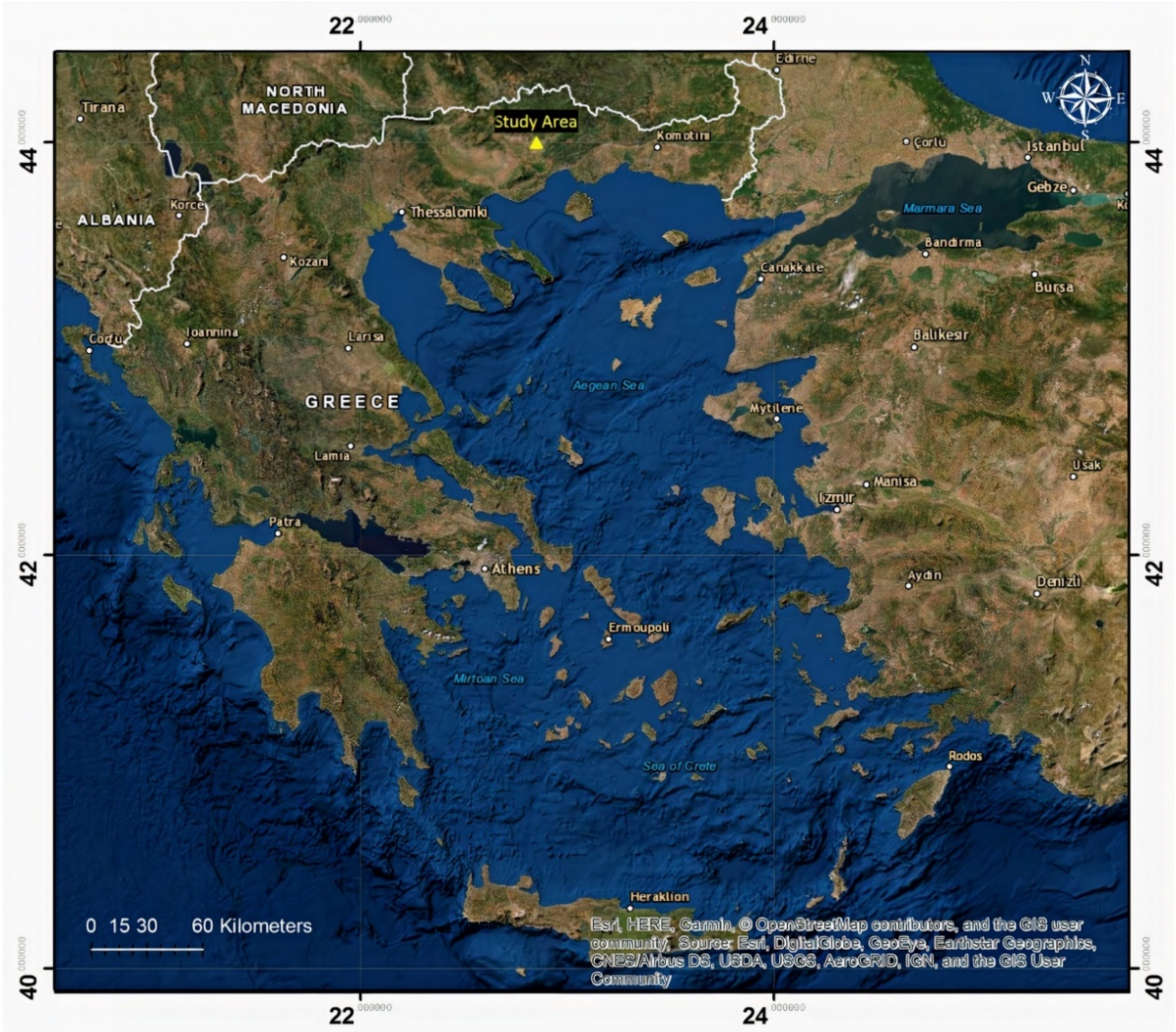
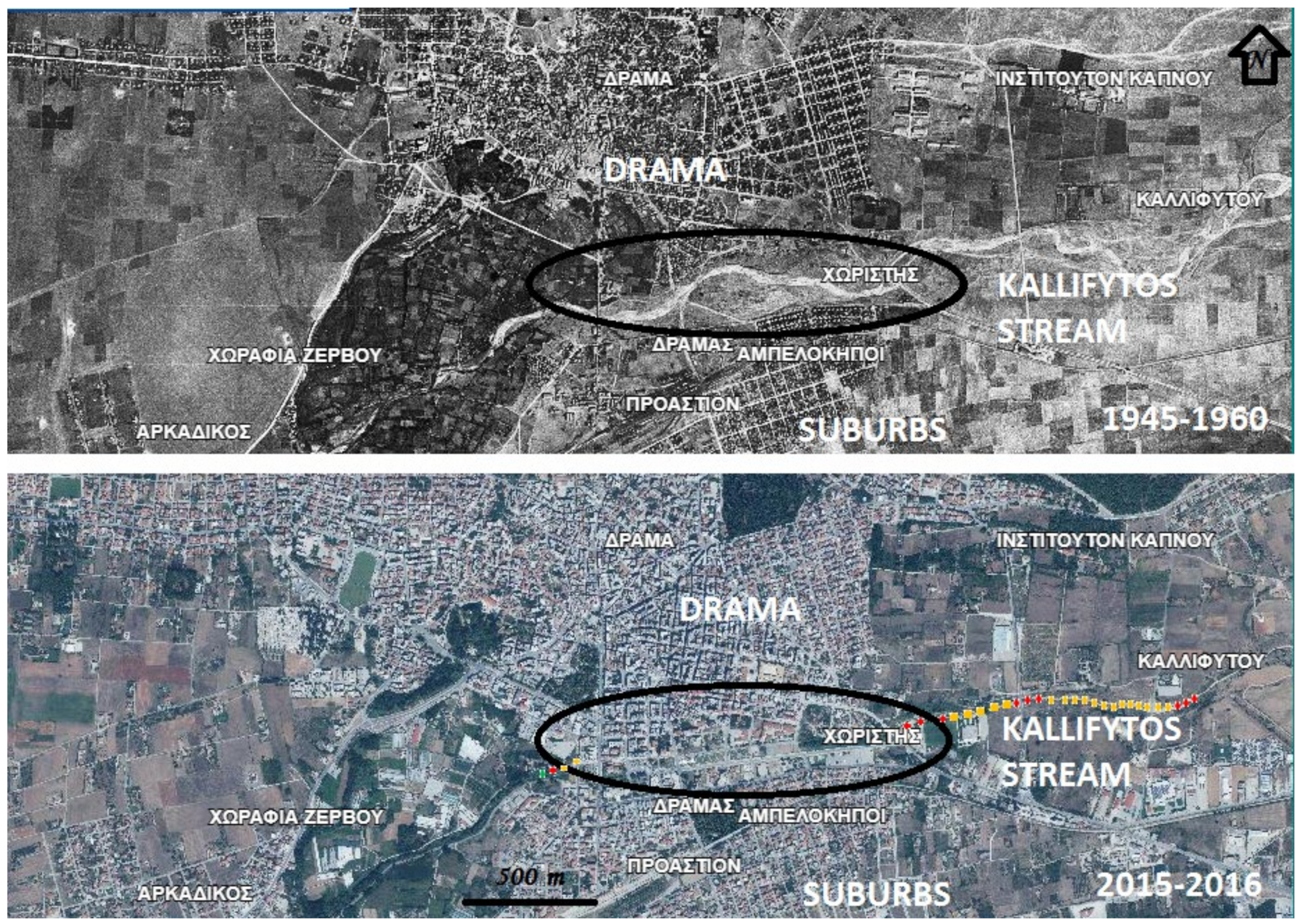
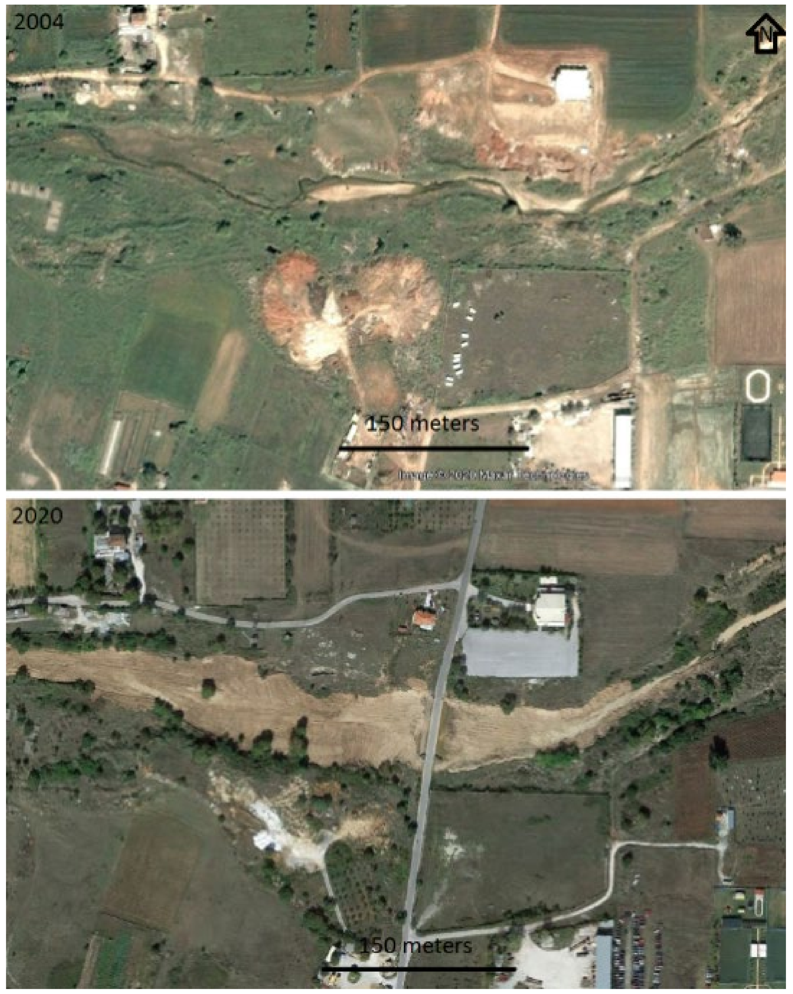
2.1. Study Torrent Reach
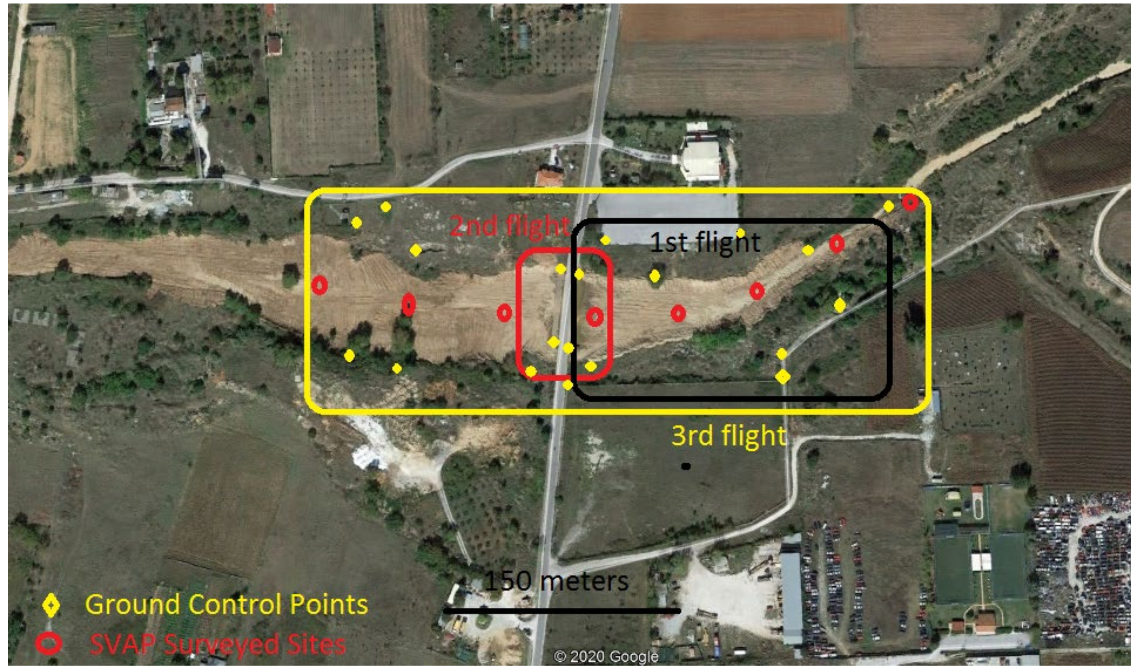
2.2. Airborne and Field Measurements
- (i)
- 1st flight—31 January 2020 (black area). This flight focused on the area starting upstream from the bridge and covering the upland bed. This flight lasted 20 min and captured 97 images. Based on the images of this flight, emphasis was given to recording and showcasing the newly formed torrent bed and flow paths. The day before the flight high flows passed through the torrent.
- (ii)
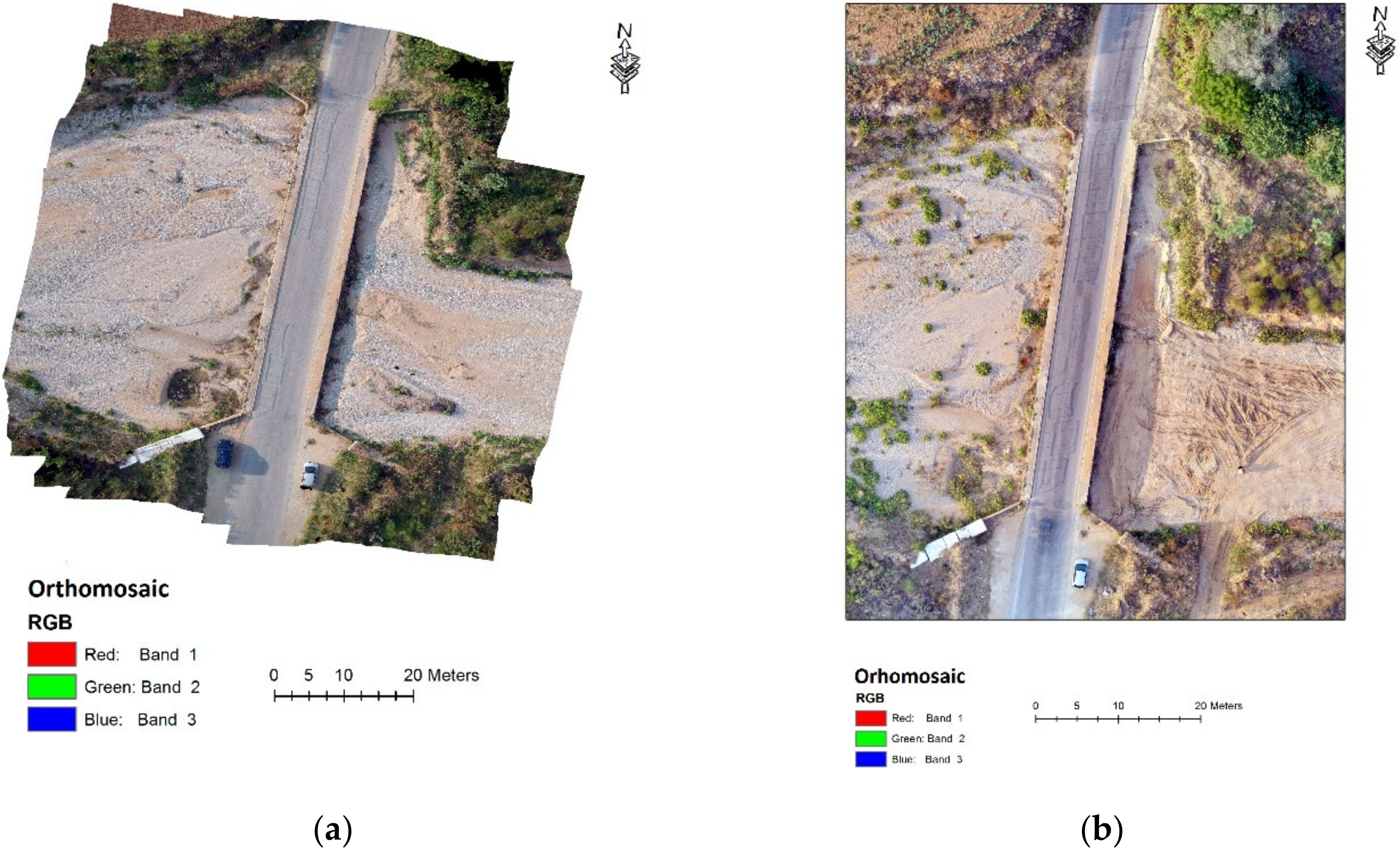
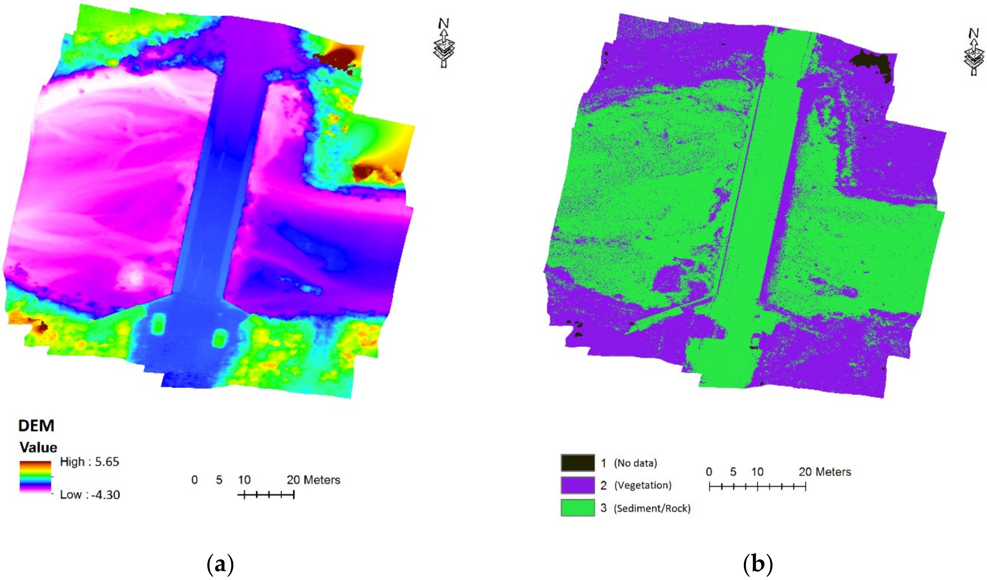
- 2nd flight—7 August 2020 (red area). This flight targeted the area surrounding the bridge. It lasted 10 min and captured 60 images. These images allowed to record flow paths, debris material, torrent bed substrate, and geomorphological and riparian vegetation changes.
- (iii)
- 3rd flight—19 September 2020 (yellow area). This final flight included a wider area of both sides of the banks of the bridge. This flight lasted 25 min and captured 196 images. Based on this flight, the torrent bank floodplain and riparian zone were delineated. In addition, the images of this flight were compared to the images of the 2nd flight to assess geomorphological and riparian vegetation changes.
2.3. Software for the Analyis of the UAV Images
2.4. Stream Visual Assessment Protocol (SVAP)—Field and Image Assessments
3. Results
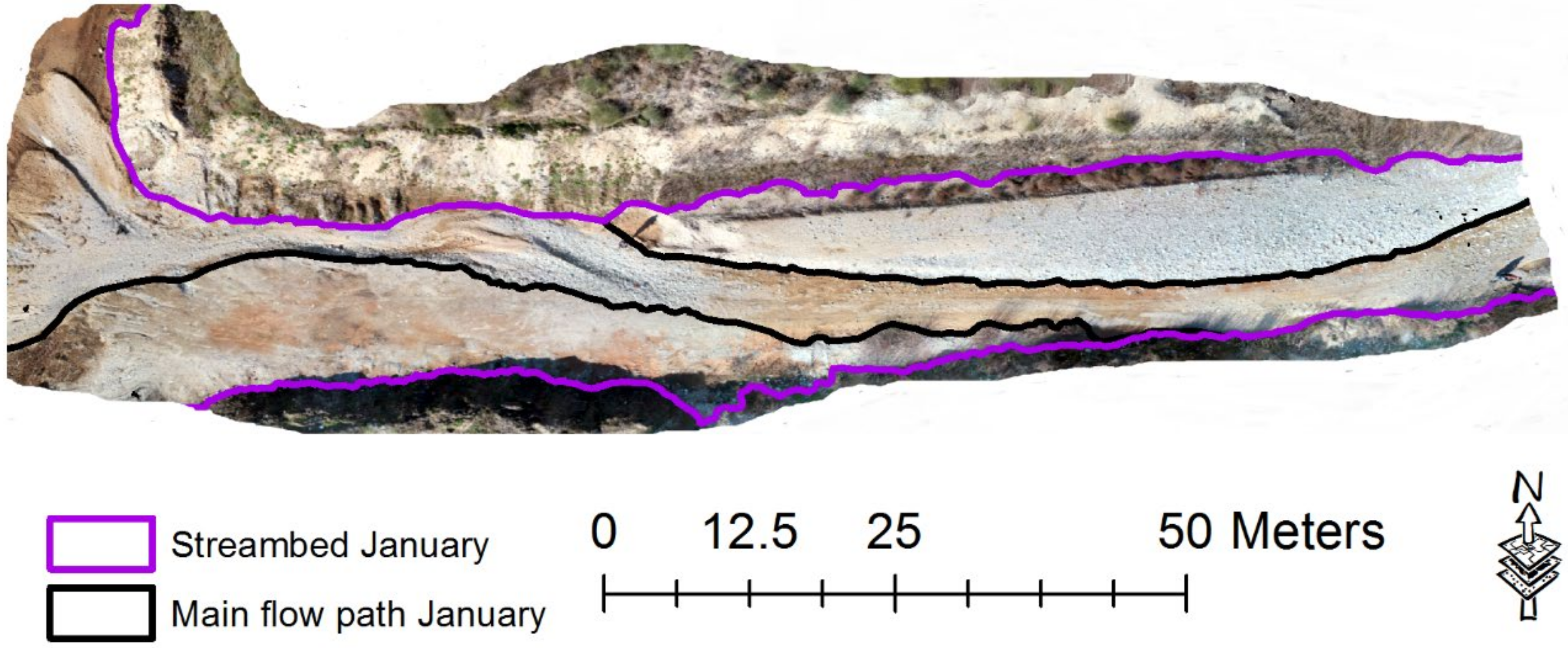
3.1. 1st Flight—Showcasing the Torrent Bed and Flow Paths
3.2. 2nd Flight—Flow Paths, Flood Debris, Riparian Vegetation, and Torrent Bed Substrate
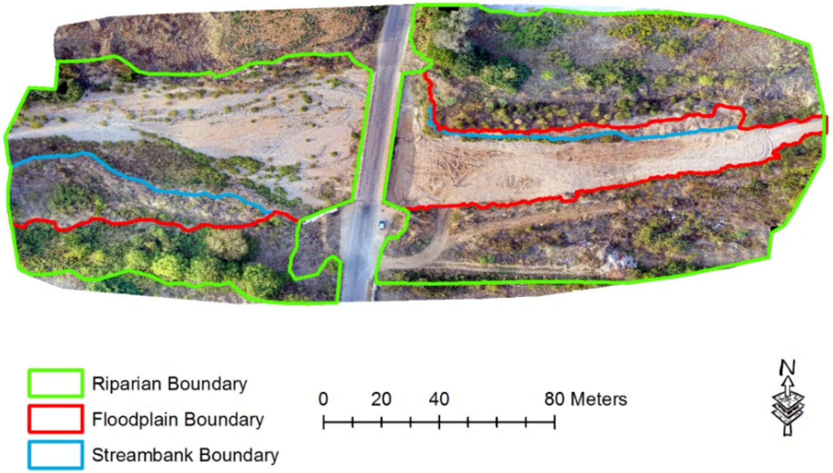
3.3. 3rd Flight—Torrent Banks, Floodplain and Riparian Zone Delineation
3.4. 2nd and 3rd Flights—Geomorphological and Riparian Vegetation Changes
3.5. 1st and 3rd Flights—SVAP Field and UAV Results—Torrent Conditions
4. Discussion
5. Conclusions
Author Contributions
Funding
Conflicts of Interest
References
- Zaimes, G.N.; Tufekcioglu, M.; Schultz, R.C. Riparian land-use impacts on stream bank and gully erosion in agricultural watersheds: What we have learned. Water 2019, 11, 1343. [Google Scholar] [CrossRef]
- Zaimes, G.N.; Ioannou, K.; Iakovoglou, V.; Kosmadakis, I.; Koutalakis, P.; Ranis, G.; Emmanouloudis, D.; Schultz, R.C. Improving soil erosion prevention in Greece with new tools. J. Eng. Sci. Technol. Rev. 2016, 9, 66–71. [Google Scholar] [CrossRef]
- Emmanouloudis, D.; Garcia Rodriguez, J.L.; Zaimes, G.N.; Gimenez Suarez, M.C.; Filippidis, E. Euro-Mediterranean torrents: Case studies on tools that can improve their management. In Mountain Ecosystems: Dynamics, Management and Conservation; Richards, K.E., Ed.; Nova Science Publishers: Hauppauge, NY, USA, 2011; pp. 1–44. [Google Scholar]
- Saleh, A.S.; AI-Hatrushi, S.M. Torrential flood hazards assessment, management, and mitigation, in Wadi Aday, Muscat Area, Sultanate of Oman, a GIS and RS approach. Egypt. J. Remote Sens. Space Sci. 2009, 12, 71–86. [Google Scholar]
- Gaume, E.; Bain, V.; Bernardara, P.; Newinger, O.; Barbuc, M.; Bateman, A.; Blaškovičová, L.; Blöschl, G.; Borga, M.; Dumitrescu, A.; et al. A compilation of data on European flash floods. J. Hydrol. 2009, 367, 70–78. [Google Scholar] [CrossRef]
- Bouadila, A.; Tzoraki, O.; Benaabidate, L. Hydrological modeling of three rivers under Mediterranean climate in Chile, Greece, and Morocco: Study of high flow trends by indicator calculation. Arab. J. Geosci. 2020, 13, 1–17. [Google Scholar] [CrossRef]
- Kundzewicz, Z.W.; Kanae, S.; Seneviratne, S.I.; Handmer, J.; Nicholls, N.; Peduzzi, P.; Mechler, R.; Bouwer, L.; Arnell, N.; Mach, K.; et al. Flood risk and climate change: Global and regional perspectives. Hydrol. Sci. J. 2014, 59, 1–28. [Google Scholar] [CrossRef]
- Gaume, E.; Borga, M.; Llassat, M.C.; Maouche, S.; Lang, M.; Diakakis, M. Mediterranean extreme floods and flash floods. In The Mediterranean Region under Climate Change. A Scientific Update; Thiébault, S., Moatti, J.-P., Eds.; IRD Editions. Coll. Synthèses: Marseille, France, 2016; pp. 133–144. [Google Scholar]
- Rault, P.A.; Koundouri, P.; Akinsete, E.; Ludwig, R.; Huber-Garcia, V.; Tsani, S.; Acuna, V.; Kalogianni, E.; Luttik, J.; Kokg, K.; et al. Down scaling of climate change scenarii to river basin level: A transdisciplinary methodology applied to Evrotas river basin, Greece. Sci. Total Environ. 2019, 660, 1623–1632. [Google Scholar] [CrossRef]
- Zaimes, G.N. Mediterranean Riparian Areas—Climate change implications and recommendations. J. Environ. Biol. 2020, 41, 957–965. [Google Scholar] [CrossRef]
- Calbo, J. Possible climate change scenarios with specific reference to Mediterranean regions. In Water Scarcity in the Mediterranean; Sabater, S., Barceló, D., Eds.; Springer: Berlin, Germany, 2010; pp. 1–13. [Google Scholar]
- Fyllas, N.M.; Christopoulou, A.; Galanidis, A.; Michelaki, C.Z.; Giannakopoulos, C.; Dimitrakopoulos, P.G.; Arianoutsou, M.; Gloor, M. Predicting species dominance shifts across elevation gradients in mountain forests in Greece under a warmer and drier climate. Reg. Environ. Chang. 2017, 17, 1165–1177. [Google Scholar] [CrossRef]
- Molnar, P. Climate change, flooding in arid environments, and erosion rates. Geology 2001, 29, 1071–1074. [Google Scholar] [CrossRef]
- Gasith, A.; Resh, V.H. Streams in Mediterranean climate regions: Abiotic influences and biotic responses to predictable seasonal events. Annu. Rev. Ecol. Evol. Syst. 1999, 30, 51–81. [Google Scholar] [CrossRef]
- Peña-Angulo, D.; Nadal-Romero, E.; González-Hidalgo, J.C.; Albaladejo, J.; Andreu, V.; Barhi, H.; Bernal, S.; Biddoccu, M.; Bienes, R.; Campo, J.; et al. Relationship of weather types on the seasonal and spatial variability of rainfall, runoff, and sediment yield in the western Mediterranean basin. Atmosphere 2020, 11, 609. [Google Scholar] [CrossRef]
- Rodrigo-Comino, J.; Senciales, J.M.; Sillero-Medina, J.A.; Gyasi-Agyei, Y.; Ruiz-Sinoga, J.D.; Ries, J.B. Analysis of weather-type-induced soil erosion in cultivated and poorly managed abandoned sloping vineyards in the Axarquía Region (Málaga, Spain). Air Soil Water Res. 2019, 12, 1–11. [Google Scholar] [CrossRef]
- Midgley, T.L.; Fox, G.A.; Derek, M.; Heeren, D.M. Evaluation of the bank stability and toe erosion model (BSTEM) for predicting lateral retreat on composite streambanks. Geomorphology 2012, 145-146, 107–144. [Google Scholar] [CrossRef]
- Pierzynski, G.M.; Sims, J.T.; Vance, G.F. Soils and Environmental Quality; CRC Press: Boca Raton, FL, USA, 2000. [Google Scholar]
- Diakakis, M.; Mavroulis, S.; Deligiannakis, G. Floods in Greece, a statistical and spatial approach. Nat. Hazards 2012, 62, 485–500. [Google Scholar] [CrossRef]
- Giannaros, C.; Kotroni, V.; Lagouvardos, K.; Oikonomou, C.; Haralambous, H.; Papagiannaki, K. Hydrometeorological and socio-economic impact assessment of stream flooding in southeast Mediterranean: The case of Rafina catchment (Attica, Greece). Water 2020, 12, 2426. [Google Scholar] [CrossRef]
- Polinesi, G.; Recchioni, C.; Turco, R.; Salvati, L.; Rontos, K.; Comino, J.R.; Benassi, F. Population trends and urbanization: Simulating density effects using a local regression approach. ISPRS Int. J. Geo Inf. 2020, 9, 454. [Google Scholar] [CrossRef]
- Borga, M.; Stoffel, M.; Marchi, L.; Marra, F.; Jakob, M. Hydrogeomorphic response to extreme rainfall in headwater systems: Flash floods and debris flows. J. Hydrol. 2014, 518, 194–205. [Google Scholar] [CrossRef]
- Steiger, J.; Gurnell, A.M. Spatial hydrogeomorphological influences on sediment and nutrient deposition in riparian zones: Observations from the Garonne River, France. Geomorphology 2003, 49, 1–23. [Google Scholar] [CrossRef]
- Cooper, J.R.; Gilliam, J.W.; Daniels, R.B.; Robarge, W.P. Riparian areas as filters for agricultural sediment. Soil Sci. Soc. Am. J. 1987, 51, 416–420. [Google Scholar] [CrossRef]
- Zaimes, G.N.; Iakovoglou, V.; Emmanouloudis, D.; Gounaridis, D. Riparian areas of Greece: Their definition and characteristics. J. Eng. Sci. Technol. Rev. 2010, 3, 176–183. [Google Scholar] [CrossRef]
- Schultz, R.C.; Collettil, J.P.; Isenhart, T.M.; Simpkins, W.W.; Mize, C.W.; Thompson, M.L. Design and placement of a multi-species riparian buffer strip system. Agrofor. Syst. 1995, 29, 201–226. [Google Scholar] [CrossRef]
- Iakovoglou, V.; Zaimes, G.N.; Gounaridis, D. Riparian areas in urban settings: Two case studies from Greece. Int. J. Innov. Sustain. Dev. 2013, 7, 271–288. [Google Scholar] [CrossRef]
- Saint-Laurent, D.; Arsenault-Boucher, L.; Berthelot, J.S. Contrasting effects of flood disturbance on alluvial soils and riparian tree structure and species composition in mixed temperate forests. Air Soil Water Res. 2019, 12, 1–11. [Google Scholar] [CrossRef]
- Hefting, M.M.; Clement, J.C.; Bienkowski, P.; Dowrick, D.; Guenat, C.; Butturini, A.; Topa, S.; Pinay, G.; Verhoeven, J.T. The role of vegetation and litter in the nitrogen dynamics of riparian buffer zones in Europe. Ecol. Eng. 2005, 24, 465–482. [Google Scholar] [CrossRef]
- Zaimes, G.N.; Schultz, R.C. Riparian land-use impacts on bank erosion and deposition of an incised stream in north-central Iowa, USA. Catena 2015, 125, 61–73. [Google Scholar] [CrossRef]
- Naiman, R.J.; Decamps, H.; Pollock, M. The role of riparian corridors in maintaining regional biodiversity. Ecol. Appl. 1993, 3, 209–212. [Google Scholar] [CrossRef]
- Piégay, H.; Gurnell, A.M. Large woody debris and river geomorphological pattern: Examples from SE France and S. England. Geomorphology 1997, 19, 99–116. [Google Scholar] [CrossRef]
- Jeffries, R.; Darby, S.E.; Sear, D.A. The influence of vegetation and organic debris on flood-plain sediment dynamics: Case study of a low-order stream in the New Forest, England. Geomorphology 2003, 51, 61–80. [Google Scholar] [CrossRef]
- Wilford, D.J.; Sakals, M.E.; Innes, J.L.; Sidle, R.C.; Bergerud, W.A. Recognition of debris flow, debris flood and flood hazard through watershed morphometrics. Landslides 2004, 1, 61–66. [Google Scholar] [CrossRef]
- Church, M.; Jakob, M. What is a debris flood? Water Resour. Res. 2020, 56, e2020WR027144. [Google Scholar] [CrossRef]
- Koutalakis, P.; Zaimes, G.N.; Iakovoglou, V.; Ioannou, K. Reviewing soil erosion in Greece. Ital. J. Eng. Geol. Environ. 2015, 9, 936–941. [Google Scholar]
- Margaroni, S.G.; Tzoraki, O.; Velegrakis, A. Soil erosion risk of Lesvos Island. In Proceedings of the 11th Panhellenic Symposium on Oceanography & Fisheries, Mytilene, Lesvos, Greece, 13–17 May 2015. [Google Scholar]
- Myronidis, D.I.; Emmanouloudis, D.A.; Mitsopoulos, I.A.; Riggos, E.E. Soil erosion potential after fire and rehabilitation treatments in Greece. Environ. Model. Assess. 2010, 15, 239–250. [Google Scholar] [CrossRef]
- Anache, J.A.; Wendland, E.C.; Oliveira, P.T.; Flanagan, D.C.; Nearing, M.A. Runoff and soil erosion plot-scale studies under natural rainfall: A meta-analysis of the Brazilian experience. Catena 2017, 152, 29–39. [Google Scholar] [CrossRef]
- Moraetis, D.; Efstathiou, D.; Stamati, F.; Tzoraki, O.; Nikolaidis, N.P.; Schnoor, J.L.; Vozinakis, K. High-frequency monitoring for the identification of hydrological and bio-geochemical processes in a Mediterranean river basin. J. Hydrol. 2010, 389, 127–136. [Google Scholar] [CrossRef]
- King, C.; Baghdadi, N.; Lecomte, V.; Cerdan, O. The application of remote-sensing data to monitoring and modelling of soil erosion. Catena 2005, 62, 79–93. [Google Scholar] [CrossRef]
- Pérez, E.; García, P. Monitoring soil erosion by raster images: From aerial photographs to drone taken pictures. Eur. J. Geogr. 2017, 8, 116–128. [Google Scholar]
- Koutalakis, P.; Tzoraki, O.; Zaimes, G.N. Detecting riverbank changes with remote sensing tools. Case study: Aggitis River in Greece. An. Univ. Dunărea de Jos Galați Fasc. II Mat. Fiz. Mec. Teor./Ann. Dunarea de Jos Univ. Galati Fascicle II Math. Phys. Theor. Mech. 2019, 42, 134–142. [Google Scholar] [CrossRef]
- Restas, A. Drone applications for supporting disaster management. World J. Eng. Technol. 2015, 3, 316. [Google Scholar] [CrossRef]
- Erdelj, M.; Natalizio, E.; Chowdhury, K.R.; Akyildiz, I.F. Help from the sky: Leveraging UAVs for disaster management. IEEE Pervasive Comput. 2017, 16, 24–32. [Google Scholar] [CrossRef]
- Şerban, G.; Rus, I.; Vele, D.; Breţcan, P.; Alexe, M.; Petrea, D. Flood-prone area delimitation using UAV technology, in the areas hard-to-reach for classic aircrafts: Case study in the north-east of Apuseni Mountains, Transylvania. Nat. Hazards 2016, 82, 1817–1832. [Google Scholar] [CrossRef]
- Niethammer, U.; James, M.R.; Rothmund, S.; Travelletti, J.; Joswig, M. UAV-based remote sensing of the Super-Sauze landslide: Evaluation and results. Eng. Geol. 2012, 128, 2–11. [Google Scholar] [CrossRef]
- Koutalakis, P.; Tzoraki, O.; Zaimes, G. UAVs for hydrologic scopes: Application of a low-cost UAV to estimate surface water velocity by using three different image-based methods. Drones 2019, 3, 14. [Google Scholar] [CrossRef]
- Lou, H.; Wang, P.; Yang, S.; Hao, F.; Ren, X.; Wang, Y.; Shi, L.; Wang, J.; Gong, T. Combining and comparing an unmanned aerial vehicle and multiple remote sensing satellites to calculate long-term river discharge in an ungauged water source region on the Tibetan Plateau. Remote Sens. 2020, 12, 2155. [Google Scholar] [CrossRef]
- Yang, S.; Wang, P.; Lou, H.; Wang, J.; Zhao, C.; Gong, T. Estimating river discharges in ungauged catchments using the slope–area method and unmanned aerial vehicle. Water 2019, 11, 2361. [Google Scholar] [CrossRef]
- Zwęgliński, T. The use of drones in disaster aerial needs reconnaissance and damage assessment—Three-dimensional modeling and orthophoto map study. Sustainability 2020, 12, 6080. [Google Scholar] [CrossRef]
- Borg Galea, A.; Sadler, J.P.; Hannah, D.M.; Datry, T.; Dugdale, S.J. Mediterranean intermittent rivers and ephemeral streams: Challenges in monitoring complexity. Ecohydrology 2019, 12, e2149. [Google Scholar] [CrossRef]
- Georgi, J.N.; Sarikou, S. Unification and planning of urban public spaces in Drama, Greece with bioclimatic criteria. In Proceedings of the 46th Congress of the European Regional Science Association (ERSA) “Enlargement, Southern Europe and the Mediterranean”, Volos, Greece, 30 August–3 September 2006. [Google Scholar]
- Kirkenidis, C.; Kirkenidis, I.; Stefanidis, P. Orhtological management of hydrological runoff basins of the prefecture of drama (current situation-protective actions-perspectives). In Proceedings of the 5th International Conference on Information and Communication Technologies for Sustainable Agri-production and Environment (HAICTA 2011), Skiathos, Greece, 8–11 September 2011. [Google Scholar]
- Ananiadou-Tzimopoulou, M.; Fatouros, D.A. The Ayia Varvara site project: A case of urban landscape design. Landsc. Urban Plan. 1990, 19, 69–97. [Google Scholar] [CrossRef]
- Frisi, P. A Treatise on Rivers and Torrents: With the Method of Regulating Their Course and Channels; Longman, Hurst, Rees, Orme, and Brown: London, UK, 1861; pp. 1728–1784. [Google Scholar]
- Numbere, A.O.; Maimaitijiang, M. Mapping of Nypa palm invasion of mangrove forest using low cost and high resolution UAV digital imagery in the Niger Delta Nigeria. Curr. Trends For. Res. 2019. [Google Scholar] [CrossRef]
- Carnevali, L.; Ippoliti, E.; Lanfranchi, F.; Menconero, S.; Russo, M.; Russo, V. Close-range mini-UAVS photogrammetry for architecture survey. Int. Arch. Photogramm. Remote Sens. Spat. Inf. Sci. 2018, 42, 2. [Google Scholar] [CrossRef]
- James, M.R.; Robson, S.; d’Oleire-Oltmanns, S.; Niethammer, U. Optimising UAV topographic surveys processed with structure-from-motion: Ground control quality, quantity and bundle adjustment. Geomorphology 2017, 280, 51–66. [Google Scholar] [CrossRef]
- Stott, E.; Williams, R.D.; Hoey, T.B. Ground control point distribution for accurate kilometre-scale topographic mapping using an RTK-GNSS unmanned aerial vehicle and SfM photogrammetry. Drones 2020, 4, 55. [Google Scholar] [CrossRef]
- Laporte-Fauret, Q.; Marieu, V.; Castelle, B.; Michalet, R.; Bujan, S.; Rosebery, D. Low-cost UAV for high-resolution and large-scale coastal dune change monitoring using photogrammetry. J. Mar. Sci. Eng. 2019, 7, 63. [Google Scholar] [CrossRef]
- Themistocleous, K.; Agapiou, A.; King, H.M.; King, N.; Hadjimitsis, D.G. More than a flight: The extensive contributions of UAV flights to archaeological research–the case study of curium site in Cyprus. In Digital Heritage. Progress in Cultural Heritage: Documentation, Preservation, and Protection, Proceedings of the Euro-Mediterranean Conference EuroMed 2014, Cham, Switzerland, 3–8 November 2014; Springer: Cham, Switzerland, 2014. [Google Scholar]
- Jebur, A.; Abed, F.; Mohammed, M. Assessing the performance of commercial Agisoft PhotoScan software to deliver reliable data for accurate3D modelling. In Proceedings of the 3rd International Conference on Buildings, Construction and Environmental Engineering, BCEE3-2017, Sharm el-Shiekh, Egypt, 23–25 October 2017; MATEC Web of Conferences, EDP Sciences: Les Ulis, France, 2018; Volume 162, p. 11. [Google Scholar]
- Turner, D.; Lucieer, A.; Wallace, L. Direct georeferencing of ultrahigh-resolution UAV imagery. IEEE Trans. Geosci. Remote Sens. 2013, 52, 2738–2745. [Google Scholar] [CrossRef]
- Bjorkland, R.; Pringle, M.C.; Newton, B. A stream visual assessment protocol (SVAP) for riparian landowners. Environ. Monit. Assess. 2001, 68, 99–125. [Google Scholar] [CrossRef] [PubMed]
- Vlami, V.; Zogaris, S.; Djuma, H.; Kokkoris, I.P.; Kehayias, G.; Dimopoulos, P. A field method for landscape conservation surveying: The landscape assessment protocol (LAP). Sustainability 2019, 11, 2019. [Google Scholar] [CrossRef]
- USDA-NRCS. Stream Visual Assessment Protocol Version 2, National Biology Handbook Subpart B—Conservation Planning; United States Department of Agriculture, Natural Resources Conservation Service: Portland, OR, USA, 2009; Part 614; p. 75. [Google Scholar]
- Gkiatas, G.; Pagonis, G.; Iakovoglou, V.; Raptis, D.; Emmanouloudis, D.; Zaimes, G.N. Assessing rural and agricultural riparian areas of Greece with the use of GIS and SVAP. In Proceedings of the Natural Resources, Green Technology and Sustainable Development-GREEN/2, Zagreb, Croatia, 5–7 October 2016; Croatian Forest Research Institute, University of Zagreb, Institute for Adriatic Crops and Karst Reclamation, Croatian Society of Biotechnology, Academy of Forestry Sciences: Zagreb, Croatia, 2016. [Google Scholar]
- Zaimes, G.N.; Iakovoglou, V.; Koutalakis, P.; Kiosses, V.; Giatas, G.; Savvopoulou, A. Riparian areas as a tool to mitigate climate change impacts in urban settings: The case study of Drama City, Greece. In Proceedings of the International Conference on Climate Change and Forestry, Antalya, Turkey, 13–14 November 2019; Atvin Coruh University: Artvin, Turkey, 2019. [Google Scholar]
- Iakovoglou, V.; Koutsoumis, A.; Zaimes, G.N.; Emmanouloudis, D. Using the Stream Visual Assessment Protocol (SVAP) to evaluate the streams and their riparian areas of the Volvi Lake watershed in Greece. In Proceedings of the International Caucasia Forestry Symposium, Artvin, Turkey, 24–26 October 2013; Atvin Coruh University: Artvin, Turkey, 2013. [Google Scholar]
- Sauquet, E.; van Meerveld, I.; Sefton, C.; Gallart, F.; Laaha, G.; Bezdan, A.; Banasik, K.; De Girolamo, A.M.; Gauster, T.; Karagiozova, T.; et al. A Catalogue of European Intermittent Rivers and Ephemeral Streams; Technical report SMIRES COST Action CA15113; HAL Archives ouvertes, Centre pour la Communication Scientifique Directe (CCSD): Lyon, France, 2019; p. 100, hal-02914572. [Google Scholar]
- Tzoraki, O.; Nikolaidis, N.P.; Amaxidis, Y.; Skoulikidis, N.T. In-stream biogeochemical processes of a temporary river. Environ. Sci. Technol. 2007, 41, 1225–1231. [Google Scholar] [CrossRef]
- Gallart, F.; Prat, N.; García-Roger, E.M.; Latron, J.; Rieradevall, M.; Llorens, P.; Barberá, G.G.; Brito, D.; De Girolamo, A.M.; Lo Porto, A.; et al. A novel approach to analysing the regimes of temporary streams in relation to their controls on the composition and structure of aquatic biota. Hydrol. Earth Syst. Sci. 2012, 16, 3165–3182. [Google Scholar] [CrossRef]
- Tzoraki, O. Operating small hydropower plants in Greece under intermittent flow uncertainty: The case of Tsiknias River (Lesvos). Challenges 2020, 11, 17. [Google Scholar] [CrossRef]
- Stavropoulos, S.; Zaimes, G.N.; Filippidis, E.; Diaconu, D.C.; Emmanouloudis, D. Mitigating flash floods with the use of new technologies: A multi-riteria decision analysis to map flood susceptibility for Zakynthos Island, Greece. J. Urban Reg. Anal. 2020, 12, 233–248. [Google Scholar] [CrossRef]
- Eisenbeiss, H.; Sauerbier, M. Investigation of UAV systems and flight modes for photogrammetric applications. Photogramm. Rec. 2011, 26, 400–421. [Google Scholar] [CrossRef]
- Fernández-Hernandez, J.; González-Aguilera, D.; Rodríguez-Gonzálvez, P.; Mancera-Taboada, J. Image-based modelling from unmanned aerial vehicle (UAV) photogrammetry: An effective, low-cost tool for archaeological applications. Archaeometry 2015, 57, 128–145. [Google Scholar] [CrossRef]
- Sanhueza, D.; Picco, L.; Ruiz-Villanueva, V.; Iroumé, A.; Ulloa, H.; Barrientos, G. Quantification of fluvial wood using UAVs and structure from motion. Geomorphology 2019, 345, 106837. [Google Scholar] [CrossRef]
- Seier, G.; Schöttl, S.; Kellerer-Pirklbauer, A.; Glück, R.; Lieb, G.K.; Hofstadler, D.N.; Sulzer, W. Riverine sediment changes and channel pattern of a gravel-bed mountain torrent. Remote Sens. 2020, 12, 3065. [Google Scholar] [CrossRef]
- Arthun, D.; Zaimes, G.N. Channel changes following human activity exclusion in the riparian areas of Bonita Creek, Arizona, USA. Landsc. Ecol. Eng. 2020, 16, 263–271. [Google Scholar] [CrossRef]
- Florsheim, J.L.; Mount, J.F. Restoration of floodplain topography by sand-splay complex formation in response to intentional levee breaches, Lower Cosumnes River, California. Geomorphology 2002, 44, 67–94. [Google Scholar] [CrossRef]
- Nanson, G.C.; Croke, J.C. A genetic classification of floodplains. Geomorphology 1992, 4, 459–486. [Google Scholar] [CrossRef]
- Baek, K.O.; Do Kim, Y. A case study for optimal position of fishway at low-head obstructions in tributaries of Han River in Korea. Ecol. Eng. 2014, 64, 222–230. [Google Scholar] [CrossRef]
- Wu, C.Y.; Mossa, J. Decadal-scale variations of thalweg morphology and riffle–pool sequences in response to flow regulation in the lowermost Mississippi River. Water 2019, 11, 1175. [Google Scholar] [CrossRef]
- Ilhardt, B.L.; Verry, E.S.; Palik, B.J. Defining riparian areas. Forestry and the riparian zone. In Proceedings of the Conference “Forestry and the Riparian Zone”, Orono, ME, USA, 26 October 2000. [Google Scholar]
- Bren, L.J. Riparian zone, stream, and floodplain issues: A review. J. Hydrol. 1993, 150, 277–299. [Google Scholar] [CrossRef]
- Langhammer, J.; Vacková, T. Detection and mapping of the geomorphic effects of flooding using UAV photogrammetry. Pure Appl. Geophys. 2018, 175, 3223–3245. [Google Scholar] [CrossRef]
- Langhammer, J.; Lendzioch, T.; Miřijovský, J.; Hartvich, F. UAV-based optical granulometry as tool for detecting changes in structure of flood depositions. Remote Sens. 2017, 9, 240. [Google Scholar] [CrossRef]
- Woodget, A.S.; Austrums, R. Subaerial gravel size measurement using topographic data derived from a UAV-SfM approach. Earth Surf. Process. Landf. 2017, 42, 1434–1443. [Google Scholar] [CrossRef]
- Switzer, A.D. Measuring and analyzing particle size in a geomorphic context. In Treatise on Geomorphology; Switzer, A., Kennedy, D.M., Eds.; Academic Press: San Diego, CA, USA, 2013; Volume 14, pp. 224–242. [Google Scholar]
- Uysal, M.; Toprak, A.S.; Polat, N. DEM generation with UAV Photogrammetry and accuracy analysis in Sahitler hill. Measurement 2015, 73, 539–543. [Google Scholar] [CrossRef]
- Chang, K.T.; Tsai, B.W. The effect of DEM resolution on slope and aspect mapping. Cartogr. Geogr. Inf. Syst. 1991, 18, 69–77. [Google Scholar] [CrossRef]
- Li, J.; Wong, D.W. Effects of DEM sources on hydrologic applications. Comput. Environ. Urban Syst. 2010, 34, 251–261. [Google Scholar] [CrossRef]
- Zaimes, G.N.; Tardio, G.; Iakovoglou, V.; Gimenez, M.; Garcia-Rodriguez, J.L.; Sangalli, P. New tools and approaches to promote soil and water bioengineering in the Mediterranean. Sci. Total Environ. 2019, 693, 133677. [Google Scholar] [CrossRef]


| C.S. 1 | i | ii | iii | iv | v | vi | vii | viii | ix | x | xi | xii | xiii | xiv | M | C |
|---|---|---|---|---|---|---|---|---|---|---|---|---|---|---|---|---|
| 1 | 2 | 9 | 5 | 2 | - | - | 5 | - | - | 9 | 1 | 1 | 1 | 3 | 3.8 | Poor |
| 2 | 1 | 9 | 9 | 4 | - | - | 5 | - | - | 9 | 1 | 3 | 1 | 9 | 5.1 | Poor |
| 3 | 6 | 9 | 9 | 6 | - | - | 4 | - | - | 9 | 2 | 4 | 1 | 9 | 5.9 | Poor |
| 4 | 9 | 10 | 10 | 9 | - | - | 9 | - | - | 9 | 1 | 2 | 1 | 10 | 7.0 | Moderate |
| 5 | 7 | 9 | 10 | 7 | - | - | 9 | - | - | 9 | 1 | 3 | 1 | 9 | 6.5 | Moderate |
| 6 | 9 | 9 | 10 | 9 | - | - | 9 | - | - | 9 | 2 | 3 | 1 | 10 | 7.1 | Moderate |
| 7 | 9 | 9 | 10 | 10 | - | - | 9 | - | - | 9 | 2 | 7 | 1 | 9 | 7.5 | Moderate |
| 8 | 9 | 10 | 9 | 6 | - | - | 9 | - | - | 9 | 1 | 9 | 1 | 9 | 7.2 | Moderate |
| 9 | 9 | 10 | 10 | 7 | - | - | 9 | - | - | 9 | 1 | 9 | 1 | 10 | 7.5 | Moderate |
| 10 | 4 | 9 | 9 | 10 | - | - | 10 | - | - | 9 | 1 | 9 | 1 | 8 | 7.0 | Moderate |
| 11 | 9 | 9 | 10 | 8 | - | - | 9 | - | - | 10 | 1 | 10 | 1 | 7 | 7.4 | Moderate |
| 12 | 7 | 10 | 10 | 9 | - | - | 10 | - | - | 10 | 2 | 4 | 1 | 10 | 7.3 | Moderate |
| 13 | 10 | 10 | 9 | 8 | - | - | 9 | - | - | 10 | 1 | 9 | 1 | 7 | 7.4 | Moderate |
| 14 | 10 | 9 | 10 | 9 | - | - | 9 | - | - | 9 | 5 | 5 | 1 | 6 | 7.3 | Moderate |
| 15 | 10 | 9 | 10 | 7 | 2 | 10 | 9 | 1 | 1 | 10 | 1 | 10 | 1 | 10 | 6.5 | Moderate |
| 16 | 5 | 9 | 9 | 8 | 2 | 8 | 10 | 1 | 2 | 10 | 2 | 10 | 1 | 7 | 6.0 | Poor |
| 17 | 9 | 9 | 5 | 5 | 4 | 6 | 9 | 2 | 4 | 7 | 2 | 8 | 1 | 3 | 5.3 | Poor |
| 18 | 4 | 9 | 8 | 7 | - | - | 9 | - | - | 7 | 2 | 6 | 1 | 3 | 5.6 | Poor |
| 19 | 5 | 9 | 4 | 7 | - | - | 9 | - | - | 8 | 1 | 10 | 1 | 8 | 6.2 | Moderate |
| 20 | 5 | 9 | 5 | 7 | - | - | 9 | - | - | 10 | 1 | 10 | 1 | 8 | 6.6 | Moderate |
| 21 | 5 | 10 | 5 | 7 | - | - | 10 | - | - | 9 | 1 | 8 | 1 | 8 | 6.9 | Moderate |
| 22 | 5 | 10 | 8 | 10 | - | - | 9 | - | - | 8 | 0 | 5 | 1 | 7 | 6.3 | Moderate |
| 23 | 5 | 10 | 8 | 8 | - | - | 10 | - | - | 7 | 5 | 10 | 1 | 10 | 6.8 | Moderate |
| 24 | 5 | 2 | 8 | 8 | 1 | 2 | 9 | 9 | 2 | 10 | 5 | 10 | 1 | 7 | 5.5 | Poor |
| 25 | 5 | 9 | 8 | 5 | - | - | 10 | 0 | 0 | 8 | 5 | 9 | 1 | 8 | 5.0 | Poor |
| 26 | 10 | 9 | 9 | 5 | - | - | 9 | 0 | 0 | 8 | 5 | 4 | 1 | 3 | 4.5 | Poor |
| 27 | 10 | 9 | 10 | 9 | 8 | 1 | 9 | 4 | 7 | 10 | 5 | 9 | 1 | 1 | 6.6 | Moderate |
| 28 | 10 | 9 | 10 | 5 | 7 | 1 | 9 | 10 | 5 | 10 | 8 | 9 | 1 | 5 | 7.1 | Moderate |
| 29 | 10 | 9 | 9 | 5 | 2 | 1 | 9 | 4 | 1 | 7 | 2 | 10 | 1 | 8 | 5.6 | Poor |
| 30 | 10 | 9 | 10 | 8 | 3 | 9 | 10 | 2 | 5 | 10 | 9 | 10 | 1 | 10 | 7.6 | Good |
Publisher’s Note: MDPI stays neutral with regard to jurisdictional claims in published maps and institutional affiliations. |
© 2020 by the authors. Licensee MDPI, Basel, Switzerland. This article is an open access article distributed under the terms and conditions of the Creative Commons Attribution (CC BY) license (http://creativecommons.org/licenses/by/4.0/).
Share and Cite
Koutalakis, P.; Tzoraki, O.; Gkiatas, G.; Zaimes, G.N. Using UAV to Capture and Record Torrent Bed and Banks, Flood Debris, and Riparian Areas. Drones 2020, 4, 77. https://doi.org/10.3390/drones4040077
Koutalakis P, Tzoraki O, Gkiatas G, Zaimes GN. Using UAV to Capture and Record Torrent Bed and Banks, Flood Debris, and Riparian Areas. Drones. 2020; 4(4):77. https://doi.org/10.3390/drones4040077
Chicago/Turabian StyleKoutalakis, Paschalis, Ourania Tzoraki, Giorgos Gkiatas, and George N. Zaimes. 2020. "Using UAV to Capture and Record Torrent Bed and Banks, Flood Debris, and Riparian Areas" Drones 4, no. 4: 77. https://doi.org/10.3390/drones4040077
APA StyleKoutalakis, P., Tzoraki, O., Gkiatas, G., & Zaimes, G. N. (2020). Using UAV to Capture and Record Torrent Bed and Banks, Flood Debris, and Riparian Areas. Drones, 4(4), 77. https://doi.org/10.3390/drones4040077