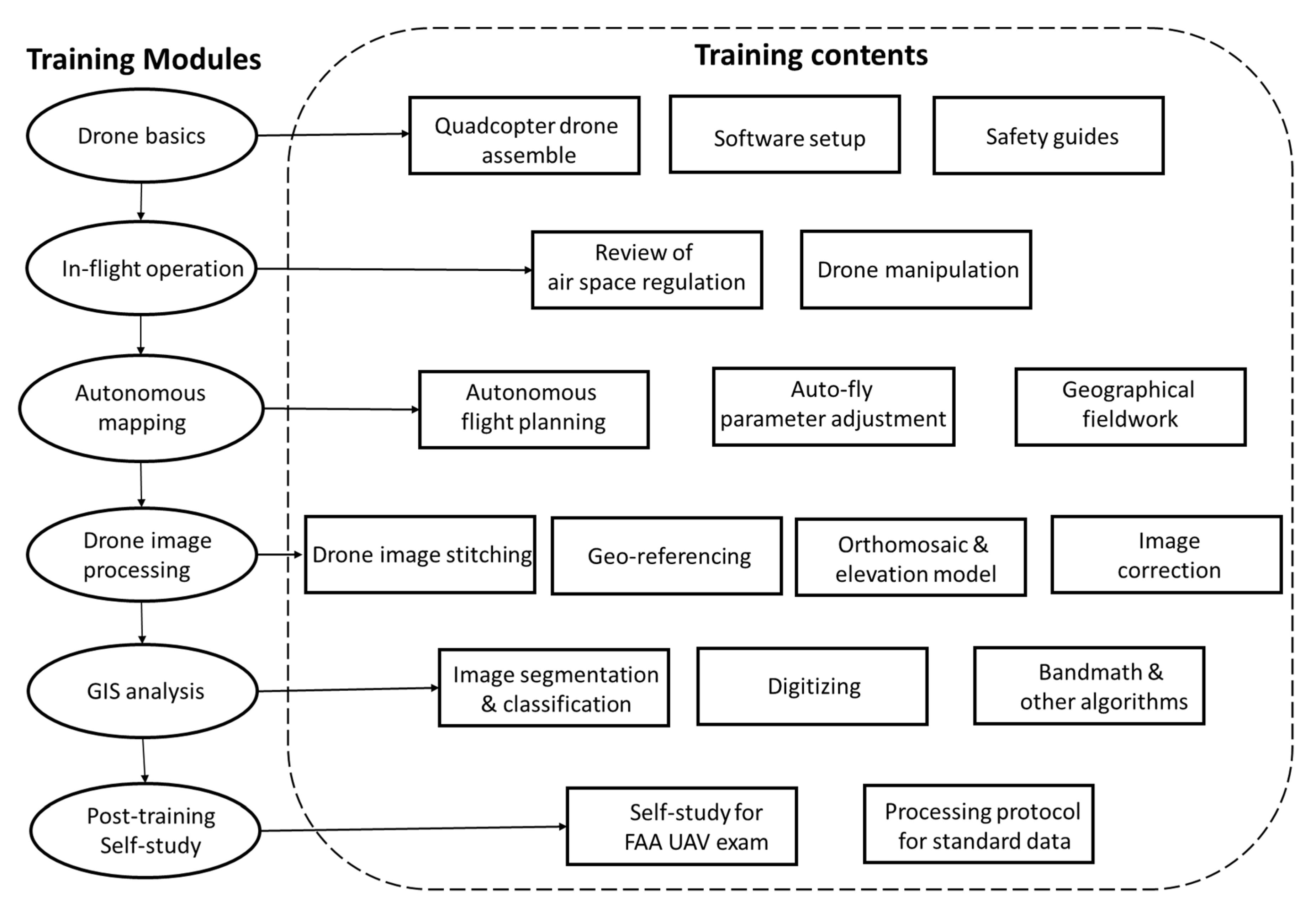
Article

Developing an Introductory UAV/Drone Mapping Training Program for Seagrass Monitoring and Research

1
Department of Sociology and College of Sciences GIS Cluster, University of Central Florida, Orlando, FL 32816, USA
2
Hakai Institute, PO Box 25039, Campbell River V9W 0B7, BC, Canada
3
Tennenbaum Marine Observatories Network, Smithsonian Institution, Edgewater, MD 21037, USA
*
Author to whom correspondence should be addressed.
Drones 2020, 4(4), 70; https://doi.org/10.3390/drones4040070
Submission received: 18 September 2020 / Revised: 28 October 2020 / Accepted: 30 October 2020 / Published: 3 November 2020
(This article belongs to the Special Issue Drones in Geography)

Abstract

:
Unoccupied Aerial Vehicles (UAVs), or drone technologies, with their high spatial resolution, temporal flexibility, and ability to repeat photogrammetry, afford a significant advancement in other remote sensing approaches for coastal mapping, habitat monitoring, and environmental management. However, geographical drone mapping and in situ fieldwork often come with a steep learning curve requiring a background in drone operations, Geographic Information Systems (GIS), remote sensing and related analytical techniques. Such a learning curve can be an obstacle for field implementation for researchers, community organizations and citizen scientists wishing to include introductory drone operations into their work. In this study, we develop a comprehensive drone training program for research partners and community members to use cost-effective, consumer-quality drones to engage in introductory drone mapping of coastal seagrass monitoring sites along the west coast of North America. As a first step toward a longer-term Public Participation GIS process in the study area, the training program includes lessons for beginner drone users related to flying drones, autonomous route planning and mapping, field safety, GIS analysis, image correction and processing, and Federal Aviation Administration (FAA) certification and regulations. Training our research partners and students, who are in most cases novice users, is the first step in a larger process to increase participation in a broader project for seagrass monitoring in our case study. While our training program originated in the United States, we discuss our experiences for research partners and communities around the globe to become more confident in introductory drone operations for basic science. In particular, our work targets novice users without a strong background in geographic research or remote sensing. Such training provides technical guidance on the implementation of a drone mapping program for coastal research, and synthesizes our approaches to provide broad guidance for using drones in support of a developing Public Participation GIS process.

1. Introduction

Unoccupied Aerial Vehicles (UAV), also known as small Unmanned Aerial Systems (sUASs), Unmanned Aerial Systems (UAS) or drones, are being embraced as an important tool to enable Public Participation Geographic Information Systems (PPGIS), a body of scholarship emphasizing open data practices and collaborative methods that include scientists and non-scientists in action-oriented research [1,2,3]. Here, we present an example from coastal research and monitoring where multidisciplinary researchers work together through an introductory drone mapping training program to understand the dynamics and drivers of coastal ecosystems, specifically seagrass habitats, and develop a broader training framework for PPGIS that aims to eventually expand participatory engagement in seagrass research and monitoring.
Seagrasses are flowering plants that have evolved to live submerged in seawater, forming dense meadows in estuaries and protected coastal seas around the world [4,5]. Habitats of seagrass support diverse and productive animal communities and provide several natural services to people, including commercial fisheries [6]. The proximity of seagrasses to industrialized areas and centers of scientific investigation in North America, Europe, and Asia has encouraged a continued scientific focus. However, seagrasses are declining in many regions due to a variety of human impacts [7]. Wasting disease caused by the slime-mold Labyrinthula zosterae has periodically caused mass mortality of eelgrass (Zostera marina) [8] and is an emerging threat along some northeast Pacific coastlines [9]. In order to determine the seascape-scale impact of the disease, and predict the future impacts with climate warming effects, a collaborative, multidisciplinary coastwide study was initiated and funded by a multi-university grant from the U.S. National Science Foundation to understand disease effects on seagrass beds and their multi-year dynamics.
UAV imagery with its high spatial resolution, temporal flexibility, and ability to repeat photogrammetry, affords a significant advancement over other traditional remote sensing approaches for change detection and assessment of coastal habitats [10,11,12]. While a typical satellite remote sensing system, such as Landsat 8 OLI/TIRS, ASTER, or Sentinel-2, has a relatively coarse resolution of 10 to 30 m [13,14], image sensors mounted on UAVs capture higher resolution imagery (< 0.1 m) [15]. Acquiring data with UAVs is often less expensive and more convenient than hiring out occupied aircraft, especially in remote and inaccessible places [10,16]. In addition, although satellites capture images of remote areas and difficult terrain, they often have infrequent and inflexible temporal revisit cycles. UAVs, on the other hand, can collect on-demand data. For coastal remote sensing, this means targeting UAV surveys during good weather windows and low tides. A variety of sensors onboard UAV platforms have been implemented and there have been many research projects employing UAVs to collect hyperspectral [17,18,19] and thermal data [20,21]. With advances in multispectral mapping sensors, UAV imagery can achieve the same spectral resolution, but much higher spatial resolution compared to satellite imagery. UAV mapping can be widely used for a variety of applications, including habitat monitoring and environmental management [10,22].
UAVs are being rapidly adopted by a range of user groups from grassroots community groups to government scientists [23]. Increased adoption of UAV technology for collaborative research also presents challenges when working with diverse users, and in variable environments [24,25,26]. These considerations can limit broad implementation within developing PPGIS settings. Groups participating in collaborative research and management projects often include a diverse range of user groups varying in backgrounds [27,28,29]. In addition, capacity for participatory engagement, including the number of personnel within a group participating, their time allocation to a project, and the technological tools at their disposal, may also differ across project participants [3,30].
While more advanced sensors can provide higher resolution and multiple color bands, there is much interest and demand for low-cost, off-the-shelf sensors on UAVs to support basic science. This training program focuses on low-cost RGB sensors on consumer-quality drones (specifically a DJI Phantom 4 Pro) as an avenue for increasing the utility of drones in marine science and monitoring projects by teams that include beginner drone users. We offer such an emphasis with the understanding that many science teams are interested in base-level data to support their fieldwork protocols, yet are unable to devote ample amounts of time and financial costs to engage in more advanced training programs or full degree programs or to purchase more expensive equipment. This article attempts to offer a compromise for such situations by exploring ways to train beginner drone users in the basics of drone operations, with the understanding that more advanced functions and systems should be done with more specialized teams.
The training program aimed to train local partners to use a cost-effective UAV solution for seagrass mapping and change detection along the west coast of North America, as well as facilitate the current ongoing research and coastal conservation activities of a larger collaborative grant. In doing so, the training program sought to develop a set of practices to guide coastal and marine science, and demonstrate potential training ideas for researchers at other sites to enhance the participation of novice drone users in their work. Our work suggests that seagrass monitoring field teams can effectively participate in the entry-level stages of drone training and basic flight operations to support broader work at their field sites. We recognize that many online resources are available to prepare trainees for a variety of tasks related to drone mapping. Teams with beginners have often expressed frustration to us about the breadth and variety of all of the resources available. We imagine that such frustrations exist beyond the teams we work with. For these reasons, and to support Findable, Accessible, Interoperable and Reusable (FAIR) science principles [31], we aim to synthesize the basic elements of a drone training program to engage beginner users in basic science that can support marine environments and seagrass monitoring in the leading journal for drones.
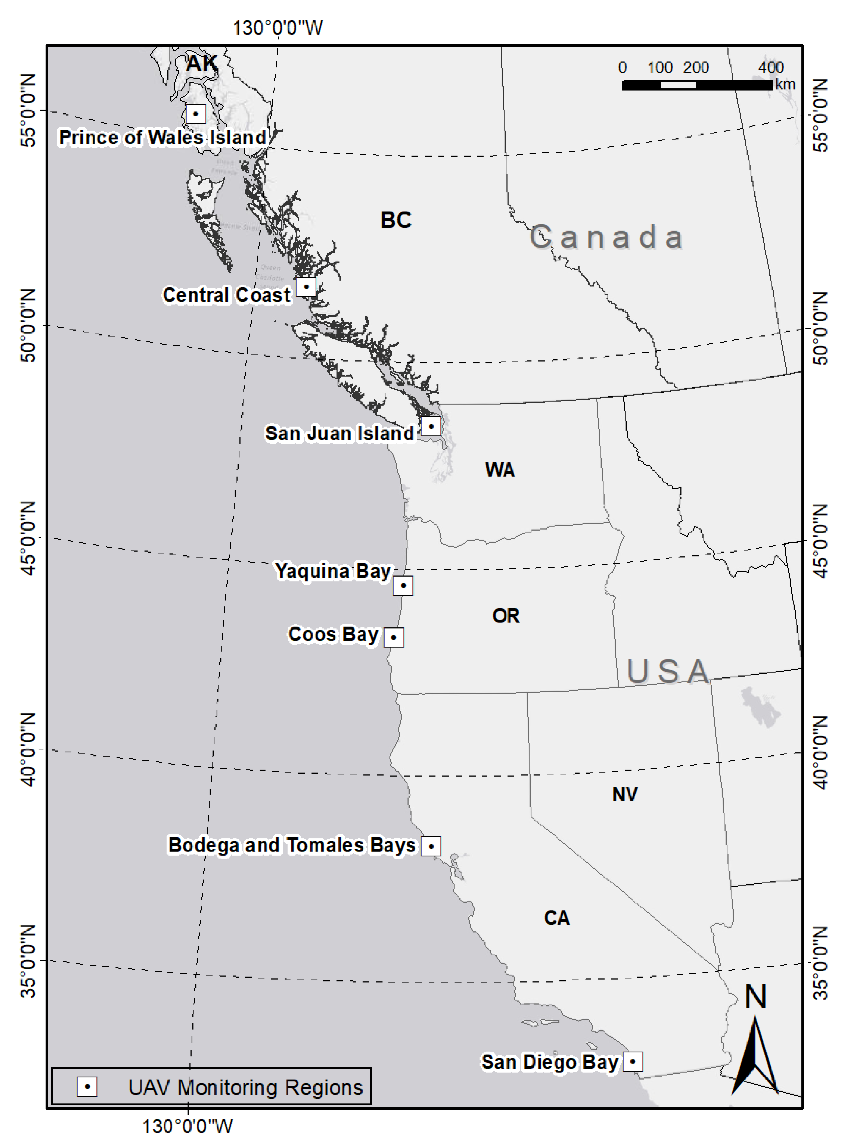
This study covers a wide range of environmental conditions, including a latitudinal gradient from Prince of Wales Island, Alaska (32.63, −117.28) to San Diego, California (55.47, −133.38). In order to broaden guidance for the implementation of drone methods in developing PPGIS research agendas in our work and in other contexts, we first review the methodological steps of our drone training course, including: how we assessed participants and provided training in drone operations; how we prepared, planned and realized flights; how we examined air space regulations; how imagery was processed and analyzed; and how data were managed. Self-study tutorials were assigned to the trainees to continue learning efforts for drone mapping. We then review the drone training course by summarizing variability in regional implementation, outcomes of the drone mapping process, and evaluation of the course by novice users. Together, this exercise aims to evaluate our process and inform our broader objective of providing adaptable, practical guidance for the use of drones in a longer-term PPGIS research context where many users may have limited drone training or experience.
Beyond the initial fieldwork training, we also discuss how our training activities continued through online collaboration. We further developed the online training course and used an online GIS platform to validate and share data with our research partners. To date, three partners in AK, WA, and CA obtained the FAA Part 107 license (a U.S. requirement for non-hobby drone flights) and contributed to time-series drone mapping independently. The steps outlined in this article demonstrate how introductory drone mapping training activities can work across disciplines to broaden the data monitoring network over a larger time frame and group of collaborators.

2. Materials and Methods

2.1. Charting a Framework for Drone Mapping in a Developing PPGIS Practice

This study aims to contribute ideas and experiences for the inclusion of drones in coastal science, management and conservation to create an eventual broader PPGIS practice in our study area. In this article, we discuss step one of our training process, which focused on the core research partners who are for the most part inexperienced with drones. Lessons learned from this training inform our planning for the next stages of our developing PPGIS process. It is essential that our academic partners have a base level knowledge and set of replicable training activities and resources to support the eventual expansion of our PPGIS components in the project. We share our training framework here to support others wishing to train teams looking to expand and include beginner users and community scientists. We initiate and evaluate this work through a training program designed to expand the participation of drone users in the collection and analysis of drone imagery. Sieber (2006) outlines three interwoven themes of PPGIS that we review to lay the foundation for seagrass drone mapping: (1) people and place; (2) technology and data; and (3) process, outcome and evaluation. Following an overview of these elements as they pertain to seagrass drone mapping, we describe the drone training program developed to eventually implement these core PPGIS components.
People and place. PPGIS researchers consider people and place as part of highly localized activities, permeated with environmental and sociopolitical influences [32]. Through this work, we standardize and adapt a seagrass drone training program to diverse researchers working across a large cross-boundary coastline. The trainers in this study are 4 people from a university UAV team: one faculty member, one post-doctoral associate, and two undergraduate students. All of the team members hold the FAA Part 107 license and have extensive experience in UAV mapping. Three of the team members traveled to the field, and one of them managed and supported the project virtually. The team worked with trainees to operate the UAV efficiently, safely, ethically and consistent with FAA regulations and university policies where applicable. Training occurred during the summer because this is the growing season of the seagrass and the optimal low tide time for each of the sites. The other best low tide is around early winter, but it is not optimal for seagrass monitoring because of poor light conditions. The mapping regions are focused on seagrass beds in remote and largely non-residential areas. We applied for additional FAA permissions and nature conservation regulations working with our local partners in the planning stage of the drone mapping. For all training sites, there were 17 trainees participating in the drone training, including 4 university faculty members, 2 post-doctoral researchers, 1 research institute staff, 6 graduate students, and 4 undergraduate students. They all have research interests in seagrass monitoring, or participate in local marine research programs. In the following years more local community partners will be included in the training activities.
We divide trainees into three drone user groups based on their prior experience: (1) novices with no prior drone experience; (2) intermediate users with basic drone experiences, e.g., photograph and video capture; and (3) experts with advanced drone mapping and training. Most participants in the first year of this training program were novice users with no prior drone experience. Therefore, they were required to fully participate in all training modules. There are two community partners in WA who had previous drone experience with FAA certification. They skipped the first two basic modules of the drone training, and started with learning autonomous mapping.
Technology and data. Both technological tools and the data derived from these tools are important links connecting people with products within PPGIS [2]. In this instance, drones provide the technical tools to create spatial data which are then applied to coastal seagrass research. Here, in this article, we review how our drone training program can teach technical skills to novice users to enable drone flights and processing of the derived data.
Process, outcome, and evaluation. Barndt and others argue that a key benchmark for a PPGIS project should be its appropriateness, that is, its match with an organization’s existing activities, its adaptability to local conditions such as culture and climate, and its fitness to current organizational capacity and overall goals [30,33]. As participants engage in our drone training activities, the goals, outcomes, and appropriateness of our developing PPGIS process are evaluated through a short survey after the training is carried out. Survey questions focus on confidence in safety and flight planning, flying, and data processing. Such feedback is important as our fieldwork is part of a multiple-year project. Participant opinions and comments on the implementation of drone technology through the training program provide feedback to enhance and adapt the design and organization of the training course. In this way, evaluation and iterations of the training build to support a broader PPGIS process as our focus is on novice academic users now, and eventually a broader array of non-academic, novice users later.

2.2. Aligning Drone Training with Research Project Planning

Study design. During the summer of 2019, we initiated seagrass drone mapping and training with local research partners at project sites on the west coast of North America (Figure 1). A 4-person UAV team implemented the training documents and protocol. Specifically five to six independent seagrass beds for collaborative research and training were chosen across each of the seven project regions spanning 23 degrees of latitude from Prince of Wales Island in Alaska to San Diego Bay in Southern California. Over 20 research partners and communities were trained in the summer of 2019.
In each of the U.S. training site regions, we implemented a drone training course with research partners over a one-week timeframe. During this week, we introduced drone basics and discussed our drone training manual through lectures and discussions, worked with trainees to set up drones and software for flights, and conducted hands-on training in drone mapping and flying through field-based tutorials. After a demonstration by trainers, each of the trainees completed an initial drone set up independently, and flew drones for 20 min (1 battery) with verbal assistance of trainers. The objective for the first year of the program was that all the participants could setup a drone (both hardware and software) and operate the drone to fly under the supervision of the trainers. Afterward, we used the newly-captured drone imagery to review and work with trainees on basic image processing and the derivation of data products.
The structure of our drone training program includes: how we assessed participants and provided training in drone operations; how we prepared, planned and realized flights; how we discussed air space regulations; how imagery was processed and analyzed; and how data were managed. Self-study tutorials were assigned to the trainees for continued learning efforts for drone mapping. To support open science and FAIR principles, we share our entire training course on a Github site (https://gis-yang.github.io/DroneMapping/). As a complement to this article, we describe our program content and training methods in more detail, following the series of training modules and workflow that were developed for the work (Figure 2). The training program is divided into 5 sections that were implemented in the field, and one post-training self-study guide to prepare participants for the FAA part 107 examination. This examination is necessary for commercial-based drone operators to conduct flights in the United States.

2.2.1. Drone Basics

The first training module (Figure 2 Drone Basics) included a lecture and a hands-on tutorial with the trainees to introduce basic manipulation, assembly, setup software, and calibration of the quadcopter drone. The DJI Phantom 4 Pro, a popular consumer-level system with a stock 1/2.3 inch (1.10 cm) CMOS camera sensor [34,35] retailing for USD 1500–2000 depending on specifications was used for this training. The training included a lecture-based review of the drone, its basic flight manipulation, rules and regulations for drone flights. All participants read through our team’s operations manual and then participated in a hands-on tutorial setting up the drone and software environment for a flight.
Through the lecture and tutorial, safe drone assembly techniques were reviewed as well as safety requirements. We covered pre-flight planning (e.g., remote pilot checks for safety equipment including gloves, eye protection, safety vests, radio, and life jackets if taking off from a boat) and in-flight precautions, including maintaining UAV within visual line of sight of the remote pilot. We also reviewed the requirements for drone registration consistent with FAA guidelines (https://www.faa.gov/uas/getting_started/register_drone/). Finally, we discussed the basic operating rules for flights in the U.S., including (a) standard flight altitude (< 400 feet above ground level); (b) minimum distance from clouds (> 500 feet below the cloud and 2000 feet horizontally from the cloud); and (c) maintaining a safe distance from bystanders. Because coastal mapping with drones often includes taking off and landing on a boat, these additional procedures and safety concerns were discussed. For example, hand catching of the drone on a boat was demonstrated and practiced for both takeoff and landing.

2.2.2. In-Flight Operations

Following the overview of drone basics, trainees engaged in a 1.5-h manual flying session supervised by trainers. Through this interactive exercise, participants gained experience in basic drone operations supported by instructors. Participants became familiar with manual drone operations, including takeoff and landing, changing flight altitude, and adjusting drone camera/video settings. Novice drone users served first as visual observers, monitoring the controller and tablet screen to observe real-time drone mapping of seagrass beds. Participants then practiced flying manually, focusing on maintaining visibility and line of sight with the drone and avoiding hazards. The collection of ancillary field data, e.g., ground control points, was also addressed at this stage. The trainees were supported by trainers at all times, to answer any questions, and if needed, to regain control of the UAV.

2.2.3. Autonomous Mapping

Following an understanding of manual flight operations, the next module was designed for trainees to learn how to conduct autonomous drone mapping. Autonomous mapping provides an advantage over manual flight operations by ensuring that data collection is efficient and replicable at each site. The trainees also learned to use autonomous functions to capture hundreds of images that were pre-programmed to be evenly distributed with nadir view over the mapping area. For this, we used the DJI Ground Station Pro (GS Pro) application to set the flight path. Participants learned how to plan and create autonomous flights with different mapping parameters. Considerations for autonomous parameters included: (a) tradeoffs between spatial coverage and spatial resolution (e.g., if drones fly at a higher elevation, the image coverage is larger, but the spatial resolution is coarser and vice versa); (b) appropriate settings of the camera model for a proper shooting angle to minimize sun glint; (c) how flight direction and capture mode vary depending on the shape of the site and the wind directions; and (d) how front/side overlap ratio is related to flying time and the number of batteries needed. The specific parameters associated with these considerations and their use in flight planning are provided in Table 1. Following flight software setup, the module followed with another 2-h of guided automated flights with the trainee pilot focused on keeping the drone within line of sight, and troubleshooting support provided by trainers.

2.2.4. Drone Image Processing

Following the field-based modules, trainees participated in a 1-h computer-based lab session designed to review data processing steps using a sample dataset. The general steps reviewed in this course included: image stitching, geo-referencing, derivation of orthomosaics and elevation models, and image correction (see Github site for more details). Before image processing, we reviewed the importance of visually inspecting all drone images to rule out low-quality images (e.g., blurry or oblique) and minimize measurement error in the final data products. We then walked through the use of Esri Drone2Map software to stitch together hundreds of separate images collected by drones in the field and geo-register them into orthomosaics.

2.2.5. GIS Analysis

The final training module focused on the introduction of trainees to general methods in GIS analysis, tailored here to the research goals of this project. This 2-h lab session included an introduction to geodatabase management, digitizing raster imagery, pixel-based classification methods, band math, and calculations of vegetation indexes (e.g., the Green Leaf Index). The canopy information, such as Leaf Area Index (LAI) can be derived from drone imagery as well [36]. All skills outlined here were important to the broader goals of seagrass monitoring across the study sites. As part of the development of a long term process and eventual PPGIS drone mapping framework, GIS and drone imagery analyses were introduced, but not the focus of the drone training course in Year 1. This section of the training will be expanded in future project years once more complete datasets have been compiled to investigate temporal trends in seagrass beds.

2.2.6. Self-Study for FAA Part 107 License

In addition to the above training modules, we also developed a 10-h self-paced study guide to assist partners with the Federal Aviation Administration (FAA) Part 107 examination. In order to fly drones for research purposes under the FAA’s Small UAS Rule (Part 107) in the U.S., one must obtain a Remote Pilot Certificate from the FAA. This certificate demonstrates that the remote pilot understands the regulations, operating requirements, and procedures for safely flying drones. This section of our training program reviewed content from the modules as well as additional material necessary to prepare for the drone examination, including airspace concepts, weather sources, radio communications, sectional charts, and drone physics. The guide compiled (and included on Github) also includes additional online resources and sample questions for the examination. Passing this examination is a necessary step for novice drone users to showcase the skills and knowledge acquired through the drone training course to demonstrate they are capable of conducting flights independently with minimal assistance.

3. Outcomes and Data Products from the Drone Training Course

3.1. Implementation of Drone Training across Sites

At each study site (Figure 1), 5–6 seagrass meadows were mapped as a collaborative component of annual seagrass monitoring for the broader project. While the course modules were standardized across regions, we adapted drone training course content to the different environmental conditions found from Alaska to Southern California, as well as localized regulatory rules for drone operations, which together influenced safety considerations across sites. In the following section, we describe the field considerations when drone mapping seagrass beds.

3.1.1. Planning and Training for Environmental Variability between Sites

There are many environmental variables that affect drone flying. One of the most important for seagrass growing in the intertidal zone is the timing of low tide to improve visibility of the subtidal edge of the seagrass bed. The timing and magnitude of tides varied within and between sites in this study. Planning for the hands-on drone mapping modules, and optimal mapping of all sites within a region, therefore, required paying close attention to the limitations imposed by differences in tidal height and timing of low tide across sites. The timing and magnitude of tides varied within and between the different regions and bays in this study. For instance, Tomales Bay in northern California is a long, narrow inlet approximately 15 miles (25 km) long and averages nearly 1.0 miles (1.6 km) wide. The low tide time is usually later than in other proximately located coastal areas due to the unique landscape. Planning for the hands-on drone mapping modules, and optimal mapping of all sites within a region, therefore, required paying close attention to the limitations imposed by differences in tidal height and timing of low tide across sites. Our mapping region is mainly focused on the intertidal area. Most of the area is not underwater during the low tide. When there are some submerged regions involved, our drone team performs calibration and water column correction with more advanced training in remote sensing and GIS, combining with the in situ measurements.
Rain, wind, and fog all frequently occur in coastal areas and influence drone flights, particularly in the Pacific Northwest regions of North America. During training flights, we required flights to be conducted with wind speeds less than 10 m/s, no heavy rain and no fog. Training across all study sites emphasized the constraints and strategies for mapping under less than ideal weather conditions.
Across all regions in this study, drone mapping was feasible when surface wind speed was less than 10 m/s. For sites with more consistent and stronger winds, the training emphasized safe drone procedures such as setting the flight parameters to fly slowly and stopping the drone when capturing the image. In addition, the UAV flight path was set to be parallel with the long side of the mapping area in order to minimize the UAV turning points and maximize battery efficiency. We also demonstrated to trainees how flying during windy days decreased flight times, so training modules also include planning for multiple battery changes when flying under windy conditions, and introduced trainees to the importance of polarizing filters, including ND4/PL, ND8/PL, and ND16/PL filters to reduce sun glare, glint over the water and increase color saturation when needed.
Foggy and rainy weather conditions are also common in the Pacific Northwest. FAA Part 107 regulations state that the UAV should not be flown in fog or other situations where the operator loses line of sight. Therefore, we reviewed the need for drone trainees to wait until areas were clear of fog to conduct the mapping. We explained to trainees that even when the fog has cleared, the air can remain humid which decreases the performance of the drone since the moisture over the drone can cause condensation. Hence, we stressed that the remote pilot should fly with extreme caution following foggy conditions. In general, foggy, rainy and windy conditions changed quickly across our study regions, which re-emphasized the need for our training to address methods for monitoring weather conditions and the in-flight response procedures by drone operators to accommodate variable weather.

3.1.2. Technical Planning for Coastal Drone Mapping

One of the biggest challenges of coastal drone mapping is that a relatively homogeneous water surface leads to difficulties in registering images because the image mosaic algorithm usually needs some target on the image as a matching point to stitch together images with overlaying parts [37,38]. To solve this problem, we used higher front/side overlap values (75–80%). At some sites, we also used buoys anchored on the water surface to help the image registration.
During image processing, rigorous geo-referencing is needed for the data to be useful for scientific research purposes [39]. The coordinate locations of ground control points (GCPs) used for geo-referencing are used in the mapping software to geo-register the images to a known coordinate system. Using a Trimble R1 GNSS high-performance handheld GPS, we collected 10 points at each monitoring site. On land, we used large colorful objects, such as red buckets, that could be easily identified in the drone image. Over water, we used light-colored buoys with anchors fixed on the water. When collecting GCP points, we recommended that trainees started the GPS and wait until there were more than 12 satellites available for calculating the position. For each GCP location, we encouraged trainers to wait at least 90 s until the GPS signal became stable. Usually, GPS accuracy can reach 30–50 cm under cloudless weather conditions. For each GCP location, we collected 20 repeated measurements and used the average value as the input coordinates for geo-referencing.
The drone training course reviewed how to set flight paths, including flight direction and capture mode setting (Table 1). In order to make the image stitching easier for the relative homogenous water region, we adjusted the overlap ratio to 65–80% and 60–70% for mapping at 200 ft and 400 ft, respectively. We used values higher than the default because coastal mapping occurs over a relatively homogeneous region with high amounts of water coverage. The higher value of the overlap ratio can eliminate the possibility of geo-registration failures due to low variation over water in particular.

3.1.3. Planning for Different Drone Regulatory Policies

U.S. Part 107 (FAA sUAS Part 107) specifies regulations to fly a UAV in the National Airspace System (NAS). Jurisdictional differences across study sites affected some flight restrictions under FAA regulations. For sites within controlled airspace, Low Altitude Authorization and Notification Capability (LAANC) and Certificates of Authorization (COAs) needed to be considered and planned for well in advance of drone operations. For some sites, due to FAA regulations, drone mapping could only be performed under certain altitudes due to mapping sites within the arrival/departure leg of airport runways. This influenced our site planning, including the decision to conduct flights at two different altitudes. Conducting flights at two different heights can generate two types of mapping products for multi-scale analyses. At 400 ft the spatial coverage is greater, while at 200 ft, the spatial resolution is finer (Table 1). As discussed with trainees, tradeoffs between spatial coverage and resolution are important to consider at the outset of a project, and this approach allowed us to consider these tradeoffs, as well as collect standardized imagery at 200 ft for all sites despite regulatory limitations to flights at 400 ft at some sites.
There are similar regulations in Canada. All drones that weigh between 250 g and 25 kg must be registered with Transport Canada. FAA certification (U.S.) is not applicable in Canada, and drone pilots must follow the rules in the Canadian Aviation Regulations (CARs) Part IX—Remotely Piloted Aircraft Systems. The drone mapping work in Canada was conducted by a research team of pilots with Canadian drone certification. The same model of drone and mapping parameters (elevation, speed, sensor, etc.) were used for both Canadian and U.S. study sites.

3.2. Results from Drone Training Implementation; Derived Data Products

As part of the drone training program, maps of seagrass beds were created in all regions for use in scientific analyses of disease ecology and other applications. Some of the maps were produced by trainees with limited training in geography and remote sensing who participated in the drone training course. We share these results here to demonstrate that even beginner drone users can create useful products to support basic science in fieldwork sites. We recognize additional advanced analyses take more training, cost and time, but for teams wishing to include low-cost and basic drone imagery operations in their fieldwork to support FAIR principles, the data products created from trainee flights in the drone training program offer much promise.
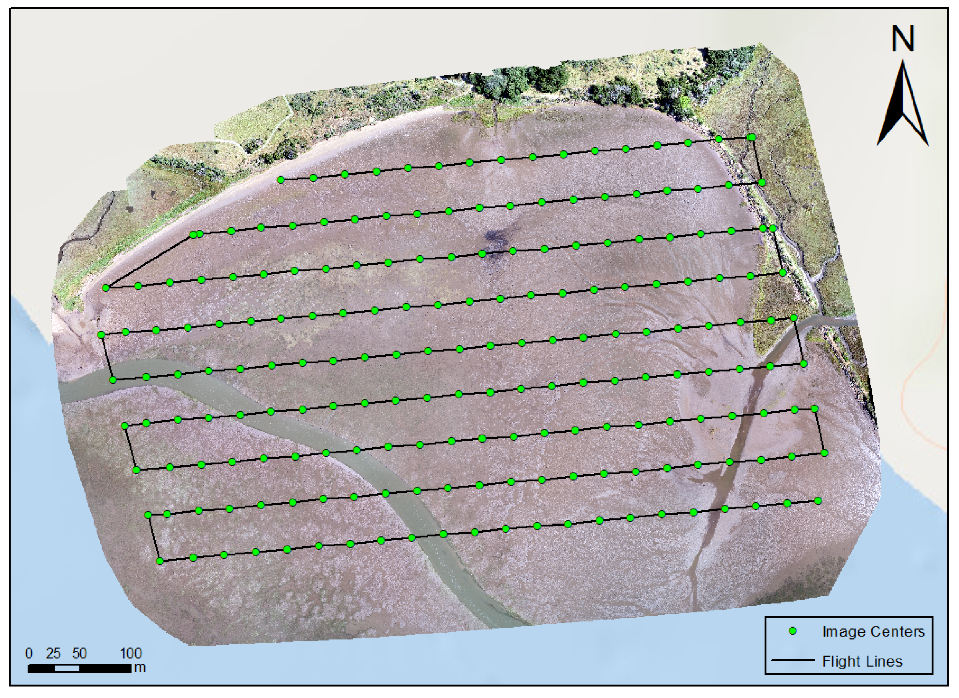
Figure 3 shows an example of the drone mapping plan for Millerton Point seagrass bed in northern California. The mapping altitude was 400 ft (120 m). The drone flight path was set to be parallel with the long side of the seagrass bed because the drone uses extra time for turning and switching to the next mapping line (Figure 4). From the image stitching results of the mapping products (Figure 4), the drone mapping results are processed to a complete orthomosaic map. All the surface patterns and features are well-captured with all images geo-registered.
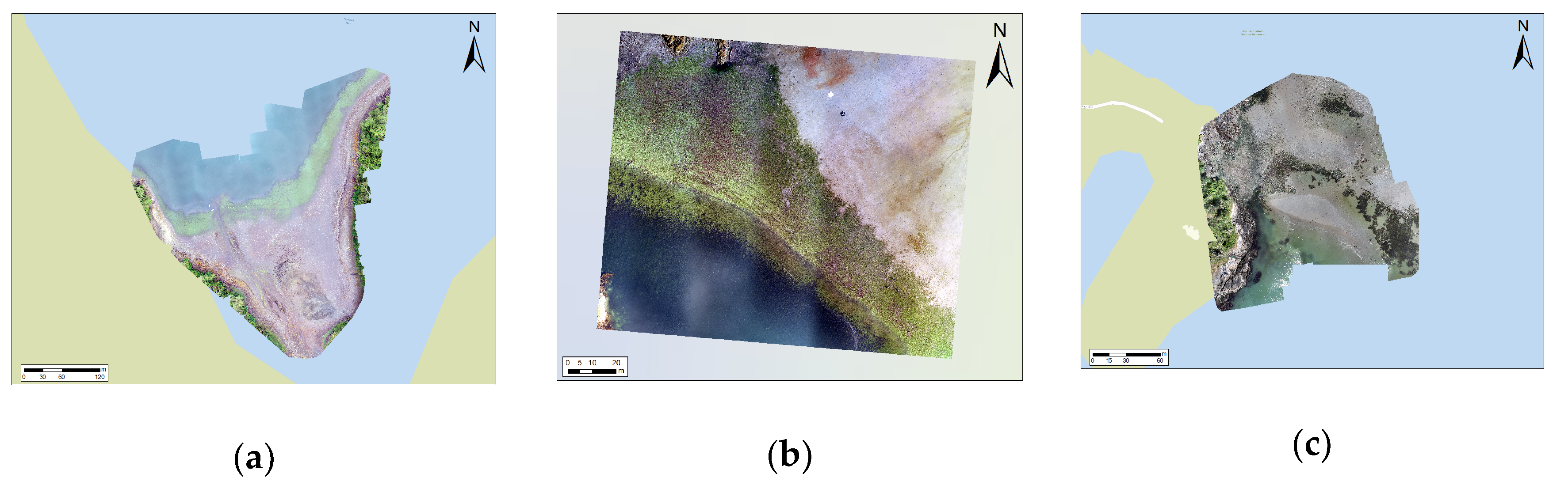
Drone mapping product examples show the variability in site characteristics across this study (Figure 4). The site-level orthomosaics show differences in the seagrass beds in terms of their spectral and spatial patterns. By visual inspection, it can be seen that the drone mapping captured the spatial details of the seagrass bed very well. The spectral and texture differences of the seagrass meadows are very clear in the drone mapping at 2–3 cm spatial resolution. For example, the greenness of the seagrass meadows in Alaska and BC, Canada are significantly richer than other sites. By comparing the drone mapping orthomosaic against the Google Earth satellite imagery, the high-resolution drone orthomosaic image captured the seagrass with much more detailed spatial information.
Once the drone imagery was processed to a map covering the study area, there were a few procedures needed to validate the quality of the map. We shared these basics with our trainees. The image needs to be reviewed with GPS locations and field photos to validate location bias and image quality. Moreover, the data need to be reviewed further with respect to large data gaps, image distortions, or artificial effects. After data cleaning and validation in our work, the validated maps along with their metadata were uploaded to ArcGIS Online directly from Drone2Map.

3.3. Preliminary Assessment of the Drone Training Course

In order to evaluate the drone training program, we created a short survey that was completed by 40% of the trainees. Overall, the training program was well-reviewed (5 out of 5 for survey questions addressing the training course’s overall quality of presentations and interactive learning opportunities).
Our survey also asked about the role of drones in future research (4.3 out of 5), which indicated that most of the trainees strongly agreed that UAV training would facilitate their future research in biology and marine science. Several of the responses to the open-ended questions discussed the relevance and importance of drone training. For instance, a professor in marine science commented on drone training:
Good introduction to the drone, how to fly it and what you can do with the data. I feel like I have a very good understanding of how things work, what kind of data we get, and what sorts of things one could do with the data. Really enjoyed it. Learned a lot. Less afraid of drones and more understanding of what the drone component of the project can contribute to work like this.
Additionally, some comments from post-doctoral researchers and graduate students in biology and marine science also discussed the importance of the drone training program:
The drone training course was great for general information about using a drone and what kinds of data you can obtain from drone and satellite images.
I got a good sense for what the drone can do, partly from the course and partly from watching the drone team in action in the field. I’m glad we got to go through both the mechanics of flying the drone and some of the basics of image analysis.
Though I now know so much more than I did before about drones (which was essentially nothing!), I still would like additional practice flying the drone with others who are experienced prior to needing to fly it independently.
Additional comments also emphasized the need for more practice and hands-on learning experience in future years of the research project.
One faculty member commented that:
If you really wanted us to be able to do independent fly, I think you’d need to have a lot more time devoted to this and more than we were able to give during the time you visited, given that we were doing our own sampling as well. So for the amount of time we had available, I thought the course was great. If we want to get the trainees to actually be proficient, then maybe in year 2 or 3 we should have one of us actually do the full drone mapping of one site with you when you visit.
The survey received a rating of 3.2 out of 5 when trainees were asked about their ability to fly the drone independently after the training. These scores reflect the short duration of the course (10 h of initial training). To help gain confidence following the training course, we also shared the training documents, software packages, and labs for self-study after the summer fieldwork.

3.4. Post-Training Materials

Although this introductory UAV training program was launched in a series of modules completed in a face-to-face environment with supervised flights for each individual trainee, for each site there were only 5–6 days to initiate training. To further build a UAV monitoring network based on this training for expansion in future years, we developed an open-access training page on Github to continue the online training. These online materials complemented the face-to-face training program allowing three partnering sites (AK, WA, and CA) to successfully obtain at least one pilot with an FAA Part 107 license within one year after the training, and allowed team members to begin collecting time-series UAV images independently and sharing the data via our online platforms.
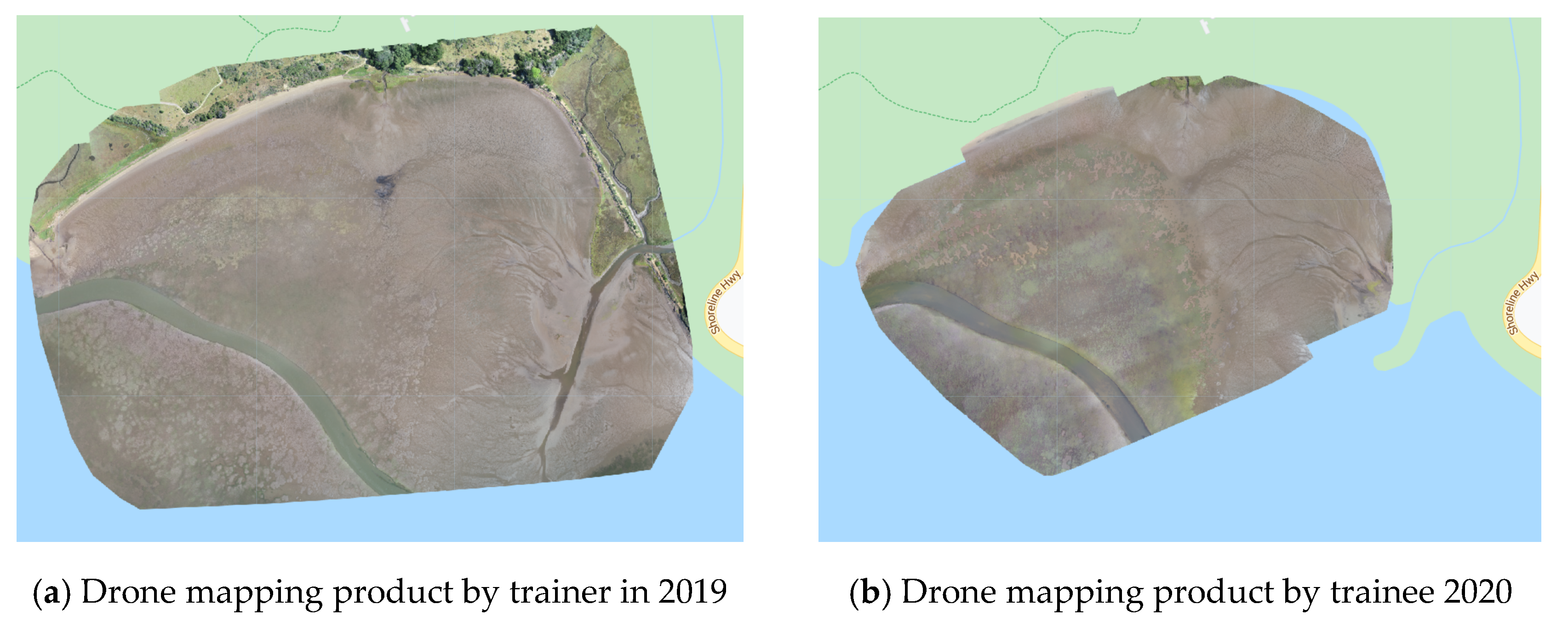
Figure 5 shows an example comparing drone mapping products for the Millerton site. On the left is the drone mapping product by a drone trainer in 2019; the right is a drone mapping product by a trainee in 2020. Such products demonstrate that beginner drone users having completed an introductory drone training program can provide useful data similar to an expert team. The detailed comparison in the online GIS platform (Google Earth Engine) can be found here (https://hao2309.users.earthengine.app/view/eelgrass-drone-image-demo).

4. Discussion

Above, we described a training program for predominantly novice drone users during an inaugural drone mapping campaign across our seagrass project’s monitoring sites. Lessons learned from our study contribute to our broader aims of developing a more general training protocol to facilitate seagrass monitoring work for various stakeholders in other areas. As such, the drone training completed in summer 2019 serves as a baseline for the development of a PPGIS process at the study sites and for consideration in other seagrass study areas around the globe. In the spirit of FAIR principles and open science, we share the training program objectives, Github site, and detailed explanations of the modules in order to show how novice trainees can be incorporated into a drone monitoring process to support basic science fieldwork. Our goal in the broader NSF grant is to take lessons learned from the introductory drone training program to eventually train community-based organizations, citizen scientists, students and teachers, scientists from other disciplines, and practitioners from a range of institutions. Time-series monitoring is critical for understanding the spatio-temporal dynamics of seagrass beds and can be enhanced through participation from beginner drone users. Such training to support basic drone operations for beginner users can be beneficial for future interdisciplinary efforts on coastal management and seagrass conservation. This is particularly important for teams like ours who are interested in engaging in additional efforts to broaden involvement in drone mapping for a monitoring network.
PPGIS pertains to the use of GIS to broaden public involvement in policymaking and to support the research needs of community stakeholders, grassroots groups and community-based organizations [2]. Collaborative engagement with local organizations and interdisciplinary researchers is often cited as one of the most valuable aspects in interdisciplinary collaborative settings [24], and can support scientific research in a variety of ways. Most information used in policymaking, whether with regard to land-use planning, environmental monitoring, habitat conservation, or social service provision, contains a spatial component. For example, seagrass beds have spatial parameters organized across different spatio-temporal scales (i.e., extent, density, bed size) [40]. Yet these spatial parameters are often the most difficult to characterize by scientists sampling seagrass and other ecosystems in the field. The incorporation of drones and GIS allows important environmental information to be analyzed and visualized spatially, and the resulting outputs (mainly maps) can persuasively convey ideas and convince people of the importance of those ideas [41]. Therefore, extending the use of spatial information from drones and GIS platforms to all relevant stakeholders can lead to a stronger interest in scientific research and policymaking [3].
As noted in our methods and results, we suggest that scientific teams wishing to include drones at a basic level in their work, consider all of the following when creating drone training opportunities for their teams. The practical considerations outlined in our training program come with time and cost constraints, which is why in our study (and in our recommendations to the broader community) we suggest front-loading the training process with the understanding of in-flight operations, regulatory and licensing guidelines, and autonomous mapping features. In our experiences, these are the initial steps needed to include new team members in drone workflows. We also recommend that teams find drone experts at local universities/colleges or in industry/consulting groups to provide training to their teams in a collaborative manner. Such training comes with highly variable costs. Teams like ours, for example, are focused on open access and low-cost training opportunities to support the next generation of novice drone operations. In this spirit, we outline our workflows and provide all training materials as open access documents following FAIR principles [31] and outline our training program on our Github site. We encourage other groups to share their knowledge through open science and collaborative workflows where possible to grow the opportunity for engagement with this expanding technology.
Training novice users does present some limitations that can be improved upon in future work. An immediate challenge is the cost of entry into drone operations. Our team specifically uses low-cost, out-of-the-box, consumer-level drones where possible in order to limit the initial financial barriers and learning curve present with more expensive and advanced models. Our imagery demonstrates that high quality, sub-meter level imagery in the RGB spectrum can be collected from such drones, yet more advanced features and multispectral or thermal imagery will need more expensive systems with a steeper learning curve. In that sense, our work limits the possibility to explore seagrass at additional wavelengths, though such work is planned for future project years with our trainees. We would encourage teams of novice users to first gain comfort with basic consumer-level options to begin their work. As they gain experience and comfort, adding more advanced drone models and sensors is an opportunity for growth. A second challenge to training novice users is related to how to process, store, and manage the high volume of drone data. Our trainees across all study sites showed strong interest in incorporating drone work, but also cautioned that drone integration would require additional logistical considerations in addition to necessary in situ sampling.
We suggest that teams weigh the costs and benefits of investing in training as they consider the inclusion of drones in their workflows. Such training is increasingly important as participants in collaborative research and management projects often include a diverse range of user groups, including community-based organizations, citizen scientists, students and teachers, scientists from other disciplines, and practitioners from a range of institutions [27,28,29]. In such cases, this large range of potential drone users may affect the level of knowledge and worldview that participants bring to the project, which can differentially impact a group or individual’s receptivity to, and ability to uptake new knowledge, educational materials and training. In addition, capacity for participatory engagement, including the number of personnel within a group participating, their time allocation to a project, as well as the technological tools at their disposal, may also differ across project participants [3,30]. Teams must think through practical costs and benefits of including these groups in their work effectively. Our work in this study suggests such opportunities are possible if novice users are exposed to multiple aspects of drone mapping workflows.
By providing drone training to a wide group of users, especially those with limited UAV backgrounds, our case study demonstrates one approach for expanding broader partnerships in coastal management and seagrass conservation. Our process considers the broader PPGIS themes of people, places, technology, and evaluation to support novice users in seagrass monitoring sites across the west coast of North America. Based on the drone training evaluation, partners were generally satisfied with the drone training course. Most participants strongly agreed that our drone training course facilitated their seagrass research and provided a powerful tool for monitoring seagrass over time and space. Participants felt that the training was well organized and effective for basic drone operations and initial flights. However, both drone mapping and training were performed within a limited time, so more training time and practice are needed for drone flying and more advanced GIS and imagery processing. Future training will build from the first year training experiences, and also include additional emphasis on data cleaning and post-processing. Greater efforts are needed to expand our drone training model to encourage novice users to engage in systematic, scientific studies of coastal seagrass in other study areas around the globe. Nevertheless, we have made significant progress toward the goal, and produced new landscape-scale products that will be valuable to the scientific understanding of coastal seagrass ecosystems while encouraging novice drone users to incorporate these emerging technologies into their work with proper training and support. We envisioned our drone training program as an important part of a long-term research project focused on seagrass monitoring, whereby trainees could take more time to further digest and practice drone training and GIS analyses on their own and with our training team and potentially engage in more advanced drone training in future years at the fieldwork sites. Yet, the beginning stages of our drone training program offer much promise and several lessons learned that are shareable with the broader community. Work such as ours supporting FAIR and open science principles offers the potential for beginner users to contribute useful data to basic science by incorporating drones into their fieldwork processes after introductory training experiences.

5. Conclusions

Through our case study, we addressed numerous drone mapping issues specific to coastal research and monitoring through the seagrass mapping fieldwork and training process. We incorporated GIS and drone mapping methodologies for those research partners who predominantly did not have a background in geography, GIS, or drones, so they can eventually assist in the consistent and replicable mapping and monitoring of seagrass sites. As shown in the drone training workflow, we developed a comprehensive drone training course, including drone basics, in-flight operations, autonomous mapping, drone image processing, GIS analysis, and associated post-training self-study. We aimed to train the first group of novice drone users across our grant study sites to employ drone technology in a systematic and standardized way to conduct seagrass mapping. In so doing, the training program sought to develop a set of practices for guiding coastal and marine science, as well as demonstrate potential training ideas for researchers at other sites to enhance the participation of novice drone users in their work. Our work suggests that seagrass monitoring field teams can effectively participate in the entry-level stages of drone training and basic flight operations to support broader work at their field sites.

Author Contributions

Conceptualization, B.Y. and T.L.H.; methodology, B.Y. and T.L.H.; software, B.Y. and L.Y.R., validation, B.Y., L.Y.R., M.F., and H.S.; formal analysis, B.Y.; investigation, B.Y.; resources, T.L.H., M.H.-L., E.J.D.; data curation, B.Y., L.Y.R., M.F., and H.S.; writing—original draft preparation, B.Y.; writing—review and editing, T.L.H., M.H.-L., E.J.D.; visualization, B.Y.; supervision, T.L.H. and E.J.D.; project administration, T.L.H. and E.J.D.; funding acquisition, E.J.D. and T.L.H. All authors have read and agreed to the published version of the manuscript.

Funding

This research was funded by the U.S. National Science Foundation under Grant No. 1829890. The lead author was also supported by the University of Central Florida Preeminent Postdoctoral Program.

Acknowledgments

This material is based upon work supported by the U.S. National Science Foundation (OCE-1829922 to JED, OCE-1829890 to TLH). This is contribution 64 from the Smithsonian’s MarineGEO and Tennenbaum Marine Observatories Network. Thanks also to the Harvell Lab at Cornell University, the Stachowicz Lab at UC Davis, University of Alaska Fairbanks, San Diego State University, Oregon State University, and Hakai Institute for their contributions to data collection on this project. Funding for MHL and LR from the Hakai Institute and Tula Foundation. Thanks to Esri and Micasense for supporting the training. This article is part of the broader research of Citizen Science GIS at University of Central Florida. We thank the editor and anonymous reviewers for their time and for improving the final article.

Conflicts of Interest

The authors declare no conflict of interest.

References

  1. Obermeyer, N.J. The evolution of public participation GIS. Cartogr. Geogr. Inf. Syst. 1998, 25, 65–66. [Google Scholar] [CrossRef]
  2. Sieber, R. Public Participation Geographic Information Systems: A Literature Review and Framework. Ann. Assoc. Am. Geogr. 2006, 96, 491–507. [Google Scholar] [CrossRef]
  3. Brown, G.; Strickland-Munro, J.; Kobryn, H.; Moore, S.A. Stakeholder analysis for marine conservation planning using public participation GIS. Appl. Geogr. 2016, 67, 77–93. [Google Scholar] [CrossRef] [Green Version]
  4. Hessing-Lewis, M.L.; Hacker, S.D.; Menge, B.A.; McConville, S.; Henderson, J. Are large macroalgal blooms necessarily bad? nutrient impacts on seagrass in upwelling-influenced estuaries. Ecol. Appl. 2015, 25, 1330–1347. [Google Scholar] [CrossRef] [Green Version]
  5. Reynolds, L.K.; Stachowicz, J.J.; Hughes, A.R.; Kamel, S.J.; Ort, B.S.; Grosberg, R.K. Temporal stability in patterns of genetic diversity and structure of a marine foundation species (Zostera marina). Heredity 2017, 118, 404–412. [Google Scholar] [CrossRef]
  6. Hemminga, M.A.; Duarte, C.M. Seagrass Ecology; Cambridge University Press: Cambridge, UK, 2000; ISBN 0521661846. [Google Scholar]
  7. Waycott, M.; Duarte, C.M.; Carruthers, T.J.B.; Orth, R.J.; Dennison, W.C.; Olyarnik, S.; Calladine, A.; Fourqurean, J.W.; Heck, K.L.; Hughes, A.R. Accelerating loss of seagrasses across the globe threatens coastal ecosystems. Proc. Natl. Acad. Sci. USA 2009, 106, 12377–12381. [Google Scholar] [CrossRef] [PubMed] [Green Version]
  8. Short, F.T.; Muehlstein, L.K.; Porter, D. Eelgrass wasting disease: Cause and recurrence of a marine epidemic. Biol. Bull. 1987, 173, 557–562. [Google Scholar] [CrossRef]
  9. Groner, M.L.; Burge, C.A.; Kim, C.J.S.; Rees, E.; Van Alstyne, K.L.; Yang, S.; Wyllie-Echeverria, S.; Harvell, C.D. Plant characteristics associated with widespread variation in eelgrass wasting disease. Dis. Aquat. Org. 2016, 118, 159–168. [Google Scholar] [CrossRef] [Green Version]
  10. Yang, B.; Hawthorne, T.L.; Torres, H.; Feinman, M. Using Object-Oriented Classification for Coastal Management in the East Central Coast of Florida: A Quantitative Comparison between UAV, Satellite, and Aerial Data. Drones 2019, 3, 60. [Google Scholar] [CrossRef] [Green Version]
  11. Jensen, J.L.R.; Mathews, A.J. Assessment of image-based point cloud products to generate a bare earth surface and estimate canopy heights in a woodland ecosystem. Remote Sens. 2016, 8, 50. [Google Scholar] [CrossRef] [Green Version]
  12. Paneque-Gálvez, J.; McCall, M.K.; Napoletano, B.M.; Wich, S.A.; Koh, L.P. Small drones for community-based forest monitoring: An assessment of their feasibility and potential in tropical areas. Forests 2014, 5, 1481–1507. [Google Scholar] [CrossRef] [Green Version]
  13. Tucker, C. Red and photographic infrared linear combinations for monitoring vegetation. Remote Sens. Environ. 1979, 8, 127–150. [Google Scholar] [CrossRef] [Green Version]
  14. Kerr, J.T.; Ostrovsky, M. From space to species: Ecological applications for remote sensing. Trends Ecol. Evol. 2003, 18, 299–305. [Google Scholar] [CrossRef]
  15. Colomina, I.; Molina, P. Unmanned aerial systems for photogrammetry and remote sensing: A review. ISPRS J. Photogramm. Remote Sens. 2014, 92, 79–97. [Google Scholar] [CrossRef] [Green Version]
  16. Cummings, A.R.; Karale, Y.; Cummings, G.R.; Hamer, E.; Moses, P.; Norman, Z.; Captain, V. UAV-derived data for mapping change on a swidden agriculture plot: Preliminary results from a pilot study. Int. J. Remote Sens. 2017, 38, 2066–2082. [Google Scholar] [CrossRef]
  17. Mitchell, J.J.; Glenn, N.F.; Anderson, M.O.; Hruska, R.C.; Halford, A.; Baun, C.; Nydegger, N. Unmanned aerial vehicle (UAV) hyperspectral remote sensing for dryland vegetation monitoring. In Proceedings of the 2012 4th Workshop on Hyperspectral Image and Signal Processing (WHISPERS), Shanghai, China, 4–7 June 2012; IEEE: Piscataway, NJ, USA, 2012; pp. 1–10. [Google Scholar]
  18. Uto, K.; Seki, H.; Saito, G.; Kosugi, Y. Characterization of Rice Paddies by a UAV-Mounted Miniature Hyperspectral Sensor System. IEEE J. Sel. Top. Appl. Earth Obs. Remote Sens. 2013, 6, 851–860. [Google Scholar] [CrossRef]
  19. Cao, J.; Leng, W.; Liu, K.; Liu, L.; He, Z.; Zhu, Y. Object-Based mangrove species classification using unmanned aerial vehicle hyperspectral images and digital surface models. Remote Sens. 2018, 10, 89. [Google Scholar] [CrossRef] [Green Version]
  20. Berni, J.; Zarco-Tejada, P.; Suárez, L. Remote sensing of vegetation from UAV platforms using lightweight multispectral and thermal imaging sensors. Sens. Spat. Inform. 2009, 38, 6. [Google Scholar]
  21. Zarco-Tejada, P.J.; González-Dugo, V.; Berni, J.A.J. Fluorescence, temperature and narrow-band indices acquired from a UAV platform for water stress detection using a micro-hyperspectral imager and a thermal camera. Remote Sens. Environ. 2012, 117, 322–337. [Google Scholar] [CrossRef]
  22. Harvey, M.C.; Pearson, S.; Alexander, K.B.; Rowland, J.; White, P. Unmanned aerial vehicles (UAV) for cost effective aerial orthophotos and digital surface models (DSM). In Proceedings of the New Zealand Geothermal Workshop 2014, Auckland, New Zealand, 24–26 November 2014. [Google Scholar]
  23. Cruzan, M.B.; Weinstein, B.G.; Grasty, M.R.; Kohrn, B.F.; Hendrickson, E.C.; Arredondo, T.M.; Thompson, P.G. Small unmanned aerial vehicleS (micro-uavS, droneS) in plant ecology 1. Appl. Plant Sci. 2016, 4, 1600041. [Google Scholar] [CrossRef]
  24. Hawthorne, T.L.; Atchison, C.; LangBruttig, A. Community geography as a model for international research experiences in study abroad programs. J. Geogr. High. Educ. 2014, 38, 219–237. [Google Scholar] [CrossRef]
  25. Birtchnell, T. Drones in human geography. In Handbook on Geographies of Technology; Edward Elgar Publishing: Cheltenham, UK, 2017. [Google Scholar]
  26. Schaub, F.; Knierim, P. Drone-based privacy interfaces: Opportunities and challenges. In Proceedings of the Twelfth Symposium on Usable Privacy and Security ({SOUPS} 2016), Denver, CO, USA, 22–24 June 2016. [Google Scholar]
  27. Loftis, J.D.; Wang, H.; Forrest, D.; Rhee, S.; Nguyen, C. Emerging Flood Model Validation Frameworks for Street-level Inundation Modeling with StormSense. In Proceedings of the 2nd International Workshop on Science of Smart City Operations and Platforms Engineering, Pittsburgh, PA, USA, 21 April 2017; pp. 13–18. [Google Scholar]
  28. Bennett-Martin, P.; Visaggi, C.C.; Hawthorne, T.L. Mapping marine debris across coastal communities in Belize: Developing a baseline for understanding the distribution of litter on beaches using geographic information systems. Environ. Monit. Assess. 2015, 188, 557. [Google Scholar] [CrossRef]
  29. Birtchnell, T.; Gibson, C. Less talk more drone: Social research with UAVs. J. Geogr. High. Educ. 2015, 39, 182–189. [Google Scholar] [CrossRef] [Green Version]
  30. McCall, M.K. Seeking good governance in participatory-GIS: A review of processes and governance dimensions in applying GIS to participatory spatial planning. Habitat Int. 2003, 27, 549–573. [Google Scholar] [CrossRef]
  31. Wilkinson, M.D.; Dumontier, M.; Aalbersberg, I.J.; Appleton, G.; Axton, M.; Baak, A.; Blomberg, N.; Boiten, J.-W.; da Silva Santos, L.B.; Bourne, P.E. The FAIR Guiding Principles for scientific data management and stewardship. Sci. Data 2016, 3, 1–9. [Google Scholar] [CrossRef] [Green Version]
  32. Laituri, M.; Harvey, L. Bridging the space between indigenous ecological knowledge and New Zealand conservation management using GIS. In Nature Conservation: The Role of Networks; Surrey Beatty and Sons: Chipping Norton, Australia, 1995; pp. 122–131. [Google Scholar]
  33. Barndt, M. A model for evaluating public participation GIS. In Community Participation and Geographic Information System; Taylor and Francis: London, UK, 2002; pp. 346–356. [Google Scholar]
  34. Stroppiana, D.; Migliazzi, M.; Chiarabini, V.; Crema, A.; Musanti, M.; Franchino, C.; Villa, P. Rice yield estimation using multispectral data from UAV: A preliminary experiment in northern Italy. In Proceedings of the 2015 IEEE International Geoscience and Remote Sensing Symposium (IGARSS), Milano, Italy, 26–31 July 2015; IEEE: Piscataway, NJ, USA, 2015; pp. 4664–4667. [Google Scholar]
  35. Themistocleous, K. The use of UAV platforms for remote sensing applications: Case studies in Cyprus. In Proceedings of the SPIE—The International Society for Optical Engineering, Paphos, Cyprus, 7–10 April 2014; Volume 9229, p. 92290S. [Google Scholar]
  36. Roth, L.; Aasen, H.; Walter, A.; Liebisch, F. ISPRS Journal of Photogrammetry and Remote Sensing Extracting leaf area index using viewing geometry effects—A new perspective on high-resolution unmanned aerial system photography. ISPRS J. Photogramm. Remote Sens. 2018, 141, 161–175. [Google Scholar] [CrossRef]
  37. Wabnitz, C.C.; Andréfouët, S.; Torres-Pulliza, D.; Müller-Karger, F.E.; Kramer, P.A. Regional-scale seagrass habitat mapping in the Wider Caribbean region using Landsat sensors: Applications to conservation and ecology. Remote Sens. Environ. 2008, 112, 3455–3467. [Google Scholar] [CrossRef]
  38. Duffy, J.P.; Pratt, L.; Anderson, K.; Land, P.E.; Shutler, J.D. Spatial assessment of intertidal seagrass meadows using optical imaging systems and a lightweight drone. Estuar. Coast. Shelf Sci. 2018, 200, 169–180. [Google Scholar] [CrossRef]
  39. Atkinson, P.M.; Cutler, M.E.J.; Lewis, H. Mapping sub-pixel proportional land cover with AVHRR imagery. Int. J. Remote Sens. 1997, 18, 917–935. [Google Scholar] [CrossRef]
  40. Boström, C.; Jackson, E.L.; Simenstad, C.A. Seagrass landscapes and their effects on associated fauna: A review. Estuar. Coast. Shelf Sci. 2006, 68, 383–403. [Google Scholar] [CrossRef]
  41. Wood, D.; Fels, J. The Power of Maps; Guilford Press: New York, NY, USA, 1992. [Google Scholar]
Figure 1. Location of drone mapping and training fieldwork along the Pacific coast of North America. From north to south, regional locations included: (1) six sites around Prince of Wales Island, Alaska; (2) five sites on the Central Coast of British Columbia; (3) five sites in the San Juan Islands; (4) three sites in Yaquina Bay, Oregon; (5) two sites in Coos Bay, Oregon; (6) six sites in Bodega Bay and Tomales Bay, northern California; and (7) six sites in San Diego and Mission Bay in southern California.
Drones 04 00070 g001
Figure 2. Drone mapping training elements and workflow.
Drones 04 00070 g002
Figure 3. Drone flight paths and geo-tagged image points for Millerton Point seagrass site in CA.
Drones 04 00070 g003
Figure 4. Example drone mapping products, (a) Nossuk in AK; (b) Superstition in Canada; (c) False Bay in WA; (b) Fossil Point in OR; (e) Millerton Point in northern CA; (f) Kendall Frost Reserve in southern CA.
Drones 04 00070 g004aDrones 04 00070 g004b
Figure 5. Drone mapping product comparison for Millerton site, Northern California; (a) Drone mapping product by trainer in 2019, (b) Drone mapping product by trainee in 2020.
Drones 04 00070 g005
Table 1. Drone mapping parameter settings.
Mapping ParametersMapping Altitude
200 ft400 ft
Flight heightCoverageSmaller coverage
Higher resolution
Larger coverage
Lower resolution
Spatial resolution
Basic settingShooting angleParallel to the main path
Capture modeEqual distance or hover and capture
Shutter interval3 s3–5 s
Advanced settingFront overlap ratio65–75%60–70%
Side overlap ratio65–75%60–70%
Course angleAdjust to parallel to the long side
Publisher’s Note: MDPI stays neutral with regard to jurisdictional claims in published maps and institutional affiliations.

