Functionality of the Land Certification Program in Ethiopia: Exploratory Evaluation of the Processes of Updating Certificates


1
Global and International Studies, Carleton University, Ottawa, ON K1S 5B6, Canada
2
Institute of Policy and Development Research, Hawassa University, P.O. Box 05 Hawassa, Ethiopia
3
College of Social Science and Humanities, Wollo University, P.O. Box 1145 Dessie, Ethiopia
*
Author to whom correspondence should be addressed.
Land 2019, 8(10), 149; https://doi.org/10.3390/land8100149
Submission received: 8 September 2019
/
Revised: 6 October 2019
/
Accepted: 10 October 2019
/
Published: 12 October 2019
Abstract
:Ethiopia has implemented one of the world’s most cost-effective systems to document land holdings, the land certification system. After more than 15 years since its launch, questions have been raised regarding its functionality. Specifically, there are concerns about the process of updating land certificates, thus ensuring the certificates and the registry are up-to-date. This exploratory evaluation seeks to provide formative evidence regarding this question, and, if warranted, give direction as to where additional research is needed. We find that in some areas, the mechanisms for updating land certificates are functional and in other areas not. Based upon these findings, we suggest four areas for future research, namely: (1) assessing the extent of non-functionality on a broader scale, (2) investigating the causes of non-functionality and viable options for addressing the cases thereof, (3) how policy can best address uninheritable land due to its small size, and (4) evaluating the viability of the future of rural livelihoods and what services ought to be put in place to enable a transition that provides decent livelihood alternatives.
1. Introduction
Due to a lack of land tenure security in Ethiopia, rural smallholders under-invested in their agricultural land and experienced conflict over land use and ownership [1,2]. To address these issues, starting in the late 1990s, the government introduced a land certification program that would grant land use rights, while the government maintained ownership of all land. The land certification program is reported to have resulted in many positive impacts, including reduced conflict, improved investment and natural resource management as well as some improvements of women’s control of land [3,4,5,6,7]. However, the long-term sustainability of these impacts depends on the continuous updating of land certificates [2]. Having effective and efficient processes to ensure the on-going functionality and relevance of the land certification program is an area identified as needing more empirical research [8]. In this exploratory evaluation, we assess (1) if certificates are being issued, (2) if certificates are being updated, and (3) what the barriers are for updating them, if any. The results of this paper provide insight into the processes of updating land certificates, a decade and a half after the program was first implemented. The objective of this approach is to help situate further studies, by providing direction as to the types of questions and metrics that might be used to assess the land certification program, and specifically the processes of updating certificates.
2. Context
During the last century, Ethiopian land tenure has gone through several significant changes. While this paper does not focus on the history of land tenure, it is worth noting the historical relevance of the land certification program and where it fits within the constellation of land tenure approaches that exist within living memory. Prior to the expansion of the central government of the modern Ethiopian state, land tenure systems were heterogeneous and highly localized. A diversity of tenure systems existed, ranging from communally managed lands of communities to local elites distributing land akin to a feudal relationship [9,10,11,12,13]. During the Imperial Regime, starting from Tewodros (1855–1968) until Haile Sellasse (ruled 1930–1974), land tenure slowly shifted toward one managed in a relatively uniform process, following moderately consistent policies. Land tenure during the Imperial era was characterized by elite ownership of land, with peasants working the land in a feudal form. This structure contributed to significant political activism in the 1960s, when demands were made to give the ‘land to the tiller’ [14].
Land tenure took a major shift during the military government (1974–1991), when land was nationalized. During this time, all tenure agreements were nullified and land was redistributed. Limitations of land holdings were instituted, and all people were eligible to receive land from the redistribution process regardless of lineage or economic status. This effectively ended the feudal style system that was built upon foundations of institutionalized discrimination and entrenched inequality. While this had positive impacts for many previously landless rural residents, it also ended communal systems of land ownership and challenged customary forms of land ownership, particularly in non-agricultural settings, such as the pastoralist areas of the east and the swidden practices of the southwest. Land redistributions were largely conducted in the years immediately following the 1975 governmental change, but additional land redistributions have taken place since (constitutionally this requires a significant majority to demand a land redistribution to take place) [15]. As a result of these legal changes, and significant land holding shifts, smallholders did not perceive that they had a high degree of land tenure security—the land redistribution after all was only usufruct rights, not ownership rights. This tenure system was largely continued with the entrance of the new government in 1991, which made only minor changes to ability to rent land on a short-term basis.
In order to improve tenure security, and thereby address problems that stemmed from a lack of it, such as conflict, lack of investment and less than idea resource management practices, the Tigray Regional State piloted a land certification program in 1998. Following the success of this initiative, the practice was adopted by Amhara Regional State in 2003, and then Oromia and the Southern Nations, Nationalities and Peoples’ Regional States in 2004. The land certificate documented the land location, size, holder and family members, offering a degree of tenure security in the form of use rights [16]. The Government of Ethiopia continued to forbid the sale or exchange of land and maintained national ownership of all lands. As noted, the program has had many positive impacts. However, the continuation of positive impacts necessitates that the land certificates be regularly updated when land is inherited or gifted. If the processes are not effective and efficient, people may not update the certificate, and as a result after a generation or two the land tenure situation may return to its previous state having low levels of tenure clarity. In this exploratory evaluation we seek to assess the process in one regional state in order to provide insight into the functionality of these processes, as well as highlight community members perception of their usefulness and effectiveness. This will aid in determining if a larger research effort is warranted in order to improve or change the processes of updating land certificates, or if the existing practices are supporting the functionality of the land certification program and its positive impacts.
In addition to the land certification system that emerged in the late 1990s and early 2000s, which was a paper-based land-use certificate, a second phase using geographic information system (GIS) technology is being implemented (generally referred to as the first stage of land registration and certification and the second stage). According to experts at the 2019 World Bank Annual conference (25–29 March 2019), the second stage is being scaled-up but remains a work in-progress (personal communication, 2 April 2019). The second stage is far more costly, and the Government of Ethiopia is being supported by a number of donors, including the World Bank and the Department for International Development (DFID), UK, to implement it. Indications suggest there is relatively low demand from land holders for the second stage certificate [17], which may relate to the causes of tenure insecurity more than the certification modality (as discussed below). At the time of this study, the second stage had not begun in South Wollo. While the first stage of the system is theoretically being phased out, it might beg the question: why study its functionality? We believe that the technical change of paper-based certificates to GIS-based certificates can be informed by lessons learned thus far. More importantly, the local governance mechanisms that will ensure the functionality of the second phase will still be utilized after the first stage is phased out, and therefore the questions of functionality still apply. For example, while the second stage may provide more accurate land certificates, the updating processes will still occur through lower-level governance structures, including the Land Administration. As a result, many of these questions continue to be of importance, even after the second stage is implemented in South Wollo.
Before moving on to the methods and findings, a note is required about the federal structure of Ethiopia and the resulting differences of land laws. As a result of Ethiopia’s federal governance system, there are both federal and regional state regulations that have to be taken into account. The land certification follows this trend, and each regional state has developed its own unique regulations outlined in their respective regional state land use proclamations. As outlined by Deininger et al. [2,18], Amhara Regional State uses a small booklet for the land certificate, issued by woredas and kebele officials, and is given free of charge. This is not the case in other regions. Tigray, Oromia and SNNPR charge fees. In Tigray, the revision and issuing are done at the kebele level. In Amhara, the certificate can be jointly held by a married couple, in Tigray, it is held by the family head and in Oromia, by the family. As this exploratory evaluation seeks to understand the processes of updating in one region, it is important to note these differences so that comparisons are not falsely drawn or expectations incorrectly held. Each regional state has proclamations regarding land use and regulations, which provide further clarity regarding land transfer, such as how land can be inherited or gifted, to whom, holding rights and responsibilities, and so forth. For Amhara Regional State, this is Proclamation 552 [19]. The land administration and use regulations in Amhara do not specify the process of land certification, but it sets the parameters for it. There are differences throughout the country within both the land administration and use regulations and the land certification programs, which have to be duly considered in making an evaluation of the implementation and functionality of the land certification system.
3. Materials and Methods
In order to assess if the processes of updating the land certificates within the land certification system are functional, we have adopted an exploratory evaluation approach. Methodologically, this involves taking an inductive research approach, whereby an initial observation is followed by the exploration of patters and the presentation of potential hypotheses. Before conducting this study, the authors had anecdotal experiences regarding land certificates not being updated, but were unaware of any studies exploring this question specifically. In addition, there have been suggestions that research on this topic be undertaken [8], as far as we know this is one of the first efforts to do so. As a first step, in a potential series of research processes, we felt it useful to conduct an exploratory study, which would guide more specific research questions, metrics and analyses of broader studies that may follow. To do this, we sought to understand the status of certification using a heuristic to categorize trends (Figure 1) in each kebele, while drawing upon qualitative data to explain how these respective outcomes have emerged. For land certification, we consider a functional system one wherein certificates are being issued and updated and a non-functional system where systems are not being issued at all. Variants of non-functionality include process barriers, such as certificates being issued but not updated over time (e.g., an institutional or administrative process), as well as user barriers, such as certificates being issued but updates are not sought by the users (e.g., knowledge, attitude or behavioral). These two components of non-functionality provide insight into the barriers of sustainability. This study has highlighted process barriers and functionality, while studies in other countries, which are discussed below, highlight user barriers.
For this exploratory study, we have focused on one area within Amhara Regional State in order to offer an assessment of the existing practices and determine if additional, larger research is necessary. Amhara Regional State was selected because land certification has been most widely implemented there, and because it was the second regional state to implement the land certification system (following Tigray). The scale and the duration of the implementation make Amhara Regional State an appropriate location for an exploratory study. The objective of this study is to assess questions related to the updating of land certificates, which would provide insight into the probability of the continuation of the positive impacts of the program. The findings are formative in the sense that they allow for an exploration into the question of an aspect of functionality, and assess if this is an area of research in need of further attention. Alternatively, it might have been the case that the findings identified that the processes of updating the land certificates were functioning well, as designed, and that the questions raised about a lack of functionality may not warrant investment in larger research efforts.
The exploratory evaluation we have adopted utilizes qualitative data collection methods. Data were collected from purposively selected woredas (districts), and a random selection of kebeles within those selected woredas. Consultation with faculty at a regional university, Wollo University, supported the purposive selection of woredas, so that the site selection would provide a range of different experiences (peri-urban and rural, road-side and more remote, different agroecological settings of relative low and medium elevation areas within the context of the highland cereal agricultural system) and be within the catchment area of Wollo University (for research clearance purposes). The variation, however, is relative; we are not comparing different livelihood systems (e.g., pastoralist or smallholder agriculture) nor different agricultural systems (e.g., root-based cropping systems). However, this variation was aimed to include many of the differences within South Wollo Zone.
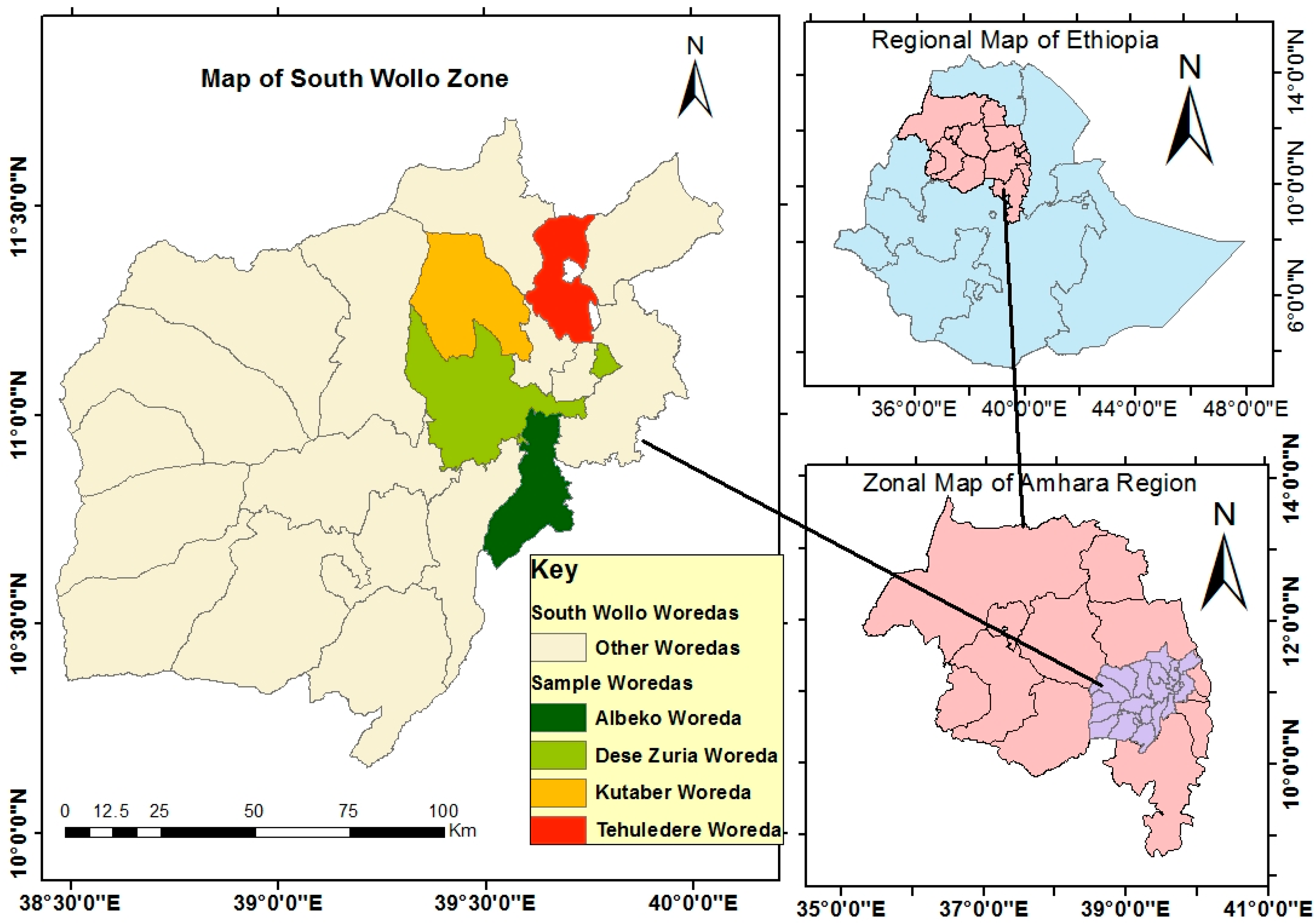
The selected woredas/districts were Albeko, Dessie Zuria, Tehuledere and Kutaber, all located in South Wollo Zone of Amhara Regional State (Figure 2). The randomization of kebeles was to reduce selection bias, even if the woreda sampling was purposive. To do this, each kebele within the selected woredas was assigned a number, and a random selection was determined using randomization software. One kebele for each of the woredas/districts was included in the study. As this evaluation was designed as an exploratory, formative assessment, we have intentionally not listed the kebeles for two reasons. First, to protect the anonymity of the respondents (even a basic presentation of data about the kebele would make them identifiable to local authorities, and potentially negative consequences for identifying non-functionality in their communities). Second, our objective is not to systematically identify which locations have functioning certificate updating processes, but rather to gauge if larger-scale, systematic research is required. We do not believe that singling out a particular location at this stage is warranted, as it may draw undue negative attention to it. Instead we focus on the processes that are occurring rather than the specific locations they are occurring within.
Within each community, we conducted individual interviews using a semi-structured format. Interviews were randomly conducted; however, in rural communities such as these this is not as simple as drawing randomized house numbers or names, as such listing are not available. As a result, we adopted a mixture of quota sampling (ensuring inclusion of socio-economic status and gender) and opportunity sampling. These approaches are not systemic nor fully randomized; we have outlined the exploratory nature of this study and its limitations below. Data were also obtained from one woreda-level land administration officer, which was one means of validating the data obtained from the woredas. It total, 39 interviews were held. The reason we opted for individual interviews was to obtain qualitative insight into what barriers exist, why and how, a level of detail that is typically not provided via household surveying. The interviewees were either land holders themselves or living in families that held land (e.g., a child farming the land held by a parent). Every person we spoke to, in all the woredas, had a land certificate, and nearly all certificates were issued in the 2003–2005 period. Due to the importance of land, and the fear of land expropriation, we avoided holding interviews with people at their homes, as this would imply we have identified their specific household or their specific land holding. Instead, we held interviews within fields, along footpaths and on transportation routes. We intentionally did not ask interviewees for their names or other personal identification information, so as to clearly convey to participants that our objective was not to identify them or their specific land holdings. All interviews were conducted in Amharic.
Making these methodological choices results in some limitations, as the setting is not private (e.g., if it were held within farmer households) nor without distractions (e.g., cattle are moving about). However, we wanted to avoid any association with the information given to their specific plots of land. One of the limitations of conducting research on land in Ethiopia anywhere in the country is the political nature of land, and its contested nature due to land tenure shifts, redistribution of land, resettlement programs (both voluntary and forced) and expropriation of land. There is no location where land is apolitical or free from complex history. In selecting these sites and methods, we have attempted to provide context on the political nature of land for readers as well as being cognizant of these issues while collecting data. The unique political and historical context of South Wollo, as with any other region, may result in specific outcomes. We recognize this limitation and present this study as an exploratory process in a limited geographic setting so as to determine if a larger research initiative on the topic should be undertaken.
We found that elders were less willing to discuss these issues, several opting not to participate in the interviews. For clarity, we use the term ‘elders’ to refer to older persons, not as persons in a particular position (the latter might be suggestive of power holders or larger land holders in the community; this was not the case, elders with small plots of land also were less interested to participate). We believe this may be due to their negative experiences with land expropriation, land (re)distribution and taxation over the long-term, as well as their desire to avoid any negative consequences that might result from sharing information about the government (which owns their land and who provides services). These experiences highlight the challenges of conducting research on land in rural Ethiopia. Far too often survey data are presented without critically reflecting on these complex histories, trends of non-participation, and potential implications and/or implied meanings of different approaches to data collection. Each method will present biases when conducting research on this politically sensitive topic. We have attempted to be transparent about these limitations, and also critically reflect on them, to enable readers to better understand the potential manifestation of bias. It may also present learning opportunities for other researchers who rely on local data collectors, for whom these experiences may be made invisible through survey data results.
4. Results
According to a woreda official at the Land Administration office, in Amhara Regional State the members of each kebele are to gather twice per year to verify that land owners match the land certificates. In the case that a land certificate needs to be updated, the case is referred by the kebele-level structures to the woreda land administration office. The process is therefore one that is identified by kebele level officials and mediated by a kebele-level committee, who liaise with woreda level officials, and it is the woreda level officials who are to update or issue land certificates. While some of the details vary, these processes are in general agreement with the descriptions of the land certification system in the literature, published works tend to focus on the initial process rather than the updating ones [2,3,4].
In the woredas where data were collected, two general trends were identified: (1) woreda—kebele collaboration and updating of land certificates, which we have categorized as a functional system, and (2) woreda—kebele non-collaboration, with disconnected processes at these levels and no certificate updating, which we have deemed a non-functional system due to process barriers. We summarize and assess the details of these two categorizations in turn as well as their implications in the following sub-sections. As an exploratory evaluation, we cannot say for certain what the root causes of the divergences or the patterns are; it may be that the core issue is one fundamental to the ideology that frames the legal system of land, it may be the land tenure and land management system, it may be that the system is theoretically fine but lacks sufficient capacity, or there may be other issues of improper or poor administration. As an exploratory evaluation, our findings are descriptive, with the objective of providing direction for future research.
4.1. Functional Systems
In two of the woredas, land certificates were being updated and new certificates issued. The exact nature of the process is not as outlined by the Land Administration officer, but it was nonetheless functional. Rather than having bi-annual community meetings and a kebele committee, when an individual needed to update a land certificate—in the case of inheritance or gift—she or he must raise the demand with the kebele administration and kebele land use committee. If there are any disputes regarding the land, the issues are supposed to be addressed at the kebele level. In some instances, these disputes were resolved and in others there were long-standing, unresolved disputes. Upon agreement at the kebele level regarding the need to update the land certificate, the case was referred to the woreda Land Administration Office for updating and/or issuing of the land certificate. The original land certificate was adjusted and/or a new certificate issued and the record is updated at the woreda Land Administration Office. With this, the updating process is complete.
In these woredas, individuals emphasized the importance of the land certificate. As is outlined in the literature, interviewees reported that the certificate enhances their sense of tenure security and their willingness to feel confident investing in their land [2,4,7]. The process was not simple or timely —for some people walking to and from the woreda and kebele offices involves significant distances and time. In every case, the process of updating took many months, longer than land holders felt was required. There were some reports of government officials accepting bribes to fast track the process of updating; however, these cases were not reported as being pervasive. For most land holders in this part of the country, land sizes are not uniform in shape nor are all lands held in a single location. Farmers report that this creates two problems. First, since the specific location of the land(s) is not listed on the land certificate, border conflicts are not resolved by the land certificate, requiring involvement by the kebele administration and land use committee for conflict resolution. Second, it was argued that the land size listed on the certificate is not accurate and interviewees reported that no measurement has taken place. In some cases, the land listed is less than the actual amount, and farmers felt that if land is not accounted for it may be appropriated by the government as not belonging to them. For example, a few farmers have begun farming in a riverside area, which is flooded by water during and after the rainy seasons but is usable for agriculture when the river recedes during the dry season. Officially, this is not eligible land to be added to the land certificate because of how that land is categorized. Since that land is not listed on their certificate, the farmers fear it may be distributed to someone else or prohibited from use. In other cases, the land listed is larger than the actual amount, such as after land is lost due to government expropriation (a railway is being built in the area, affecting many properties, and a new road was finished in 2015, also affecting many properties) meaning that individuals have to pay tax on land that they no longer have.
One of the stated objectives of the land certification system was to improve tenure security. However, one of the main reasons for tenure insecurity is government action. As noted above, this may serve a myriad of purposes, but is linked through the process of land expropriation. When done for the public good, this might take the form of building a school or a railway, but it may also be utilized to obtain land to give to investors (domestic and foreign). The threat of expropriation is severe for those living in peri-urban areas, where the question for most is not if, but when their land will be expropriated. Rural land holders have no rights to reject this process, only to negotiate compensation. Effectively, the objective of land certification is being undermined by government action. The impacts are worsened because the compensation is low and there are no appeals for land expropriation, only for the compensation amount [20]. This presents a much more systemic issue of tenure insecurity, and therefore a challenge to the viability of the land certification system. As noted at the outset, demand for second stage land certificates is low [17]; one reason for this may be that the key causes of tenure insecurity are not being addressed by the system. Uniformity and efficiency in the functionality of the system, therefore, do not address the broad systemic issues that challenge tenure security, and therefore the land certification system.
The largest complaint in the areas where a functional system operated was how the land certificate was being used to enforce taxation. Each year, whether the land certificate needed to be updated or not, the certificate had to be submitted to the kebele office for the determination and collection of tax. For the majority of farmers, who hold small plots of land (rarely more than a single hectare), taxes present a serious burden. In these areas, taxes range from 370 to 500 ETB (approx. US$ 13–18). While these are small sums in a global context, the average household in these areas does not produce (e.g., for household consumption) and/or earn a sufficient amount (e.g., sale of surplus or cash crops) to obtain basic food security [21,22,23]. Households in these areas experience high levels of chronic poverty, chronic food insecurity, and are vulnerable to drought, often requiring the provision of emergency assistance [24,25,26]. It is not that residents are unhappy with the services provided, indeed the provision of basic services (education, healthcare, transportation, telecommunication) was appreciated; rather, it is that these households have so little income that the payment of taxes poses a great difficulty—and that the government utilizes the land certificate to enforce payment. How this connects to the topic of study—the functionality of the land certification system—relates to a question about the objective of the system. For some farmers, the apparent purpose of the land certification system is not to improve tenure security, because it is felt they have no choice or option if the government takes their land. Instead, the primary purpose of the land certification system, in their experience, was the collection of taxes.
4.2. Non-Functional Systems Due to Process Barriers
In the two woredas where the system was non-functional due to process barriers, land certificates had not been updated since their issuing. This was not due to a lack of interest on the part of community members, such as not going to the kebele or woreda to request an update. In fact, community members in these areas stated that they have demanded both kebele and woreda level offices to update the certificates. To their requests, varied responses were given. One person was told that an evaluation and update will be done once every 10 years. There has not, however, been any updating since the issuing approximately 15 years ago. Another person was told that the Land Administration is in the process of printing new certificates, but each year when the certificate is submitted the old one is returned, unchanged. Yet another person explained that in fact new certificates are being issued in these non-functional areas, but only for those who bribe the officers, leaving the poorer members of society with outdated and inaccurate land certificates. One opinion regarding why the certificates are not being issued in one non-functional area was that there was high staffing turnover in the Land Administration Office, and staff do not have the resources or capacity to conduct a complete re-evaluation and updating. The majority, however, raised a concern similar to the functional areas. Interviewees felt that the land certificate system was not designed to facilitate land transfers; rather, it was designed with the objective of collecting tax. The lack of functionality of one of the basic requirements for sustainability—updating certificates—was given as evidence that little to no emphasis was placed on farmers’ interests in having them updated. Alternatively, tax collection is funded (staffing, data collection on payment) and enforced, with consequences for those who do not pay. Given this was not the case in all places, further research is needed to assess if this is a cause of non-functionality or a consequence of it.
In response to the need to resolve conflict in areas where land certificates were not being updated, the kebele administration and the kebele land use committee had developed a parallel system for updating, whereby they issued a printed piece of paper affirming the transfer of land. However, the land certificate was not updated nor were the records of the Land Administration Office. There was no record of the papers issued by the kebele, nor the information stated on them. Furthermore, the kebele-issued papers are not valid legal documents. When a dispute reaches the court, the land certificate is used, which was not updated, and the kebele-issued paper is not accepted as a valid transfer. However, in these non-functional areas, evaluations have been irregularly held, which have sought to protect the most vulnerable (elderly, female-headed households, disabled) from having their land taken from them. These evaluations also determine if a land holder is ineligible to hold land (e.g., if they are a civil servant, absentee owners, or instances of consecutive years of unused land) and to confiscate it. In these non-functional areas, an evaluation of this type occurred in 2009–2010. In two instances, new paperwork was issued following the 2009–2010 evaluation for people who did not have a land certificate from the original assessment and distribution of certificates.
In addition to challenging the functionality of the land certification system in these areas, and the positive benefits it brought about, a number of other problems have arisen. First, the rise of land conflict. Land certificates are long out of date and numerous conflicts have arisen. While the kebele-issued papers are an attempt to adjudicate the conflicts, since these are not recognized as legal documents as a land certificate is, the issues are not being resolved by it. The challenges of land conflict are not hypothetical. Interviewees we spoke with who were experiencing such land disputes used proverbs stating that they will die for their land. Second, even if land certificates are inaccurate, taxes must still be paid according to them. This creates multiple layers of conflict, such as between family members who have divided and inherited land, but one person might be forced to pay all the taxes as the land certificate shows undivided land. In other cases, such as those people who have had land expropriated by the government, those changes are not reflected on their land certificate (meaning they are still required to pay tax for that land). This creates animosity between the residents and the government. Third, since the kebele-issued papers are not reflected in the Land Administration records, land granted to investors or for development activities may create conflict as that land may no longer be owned by a single individual. However, when that land is expropriated the compensation is granted according to the land certificate, as per the record in the registry at the Land Administration. This may result in disputed allocation of compensation for lost land. Fourth, there is unregistered and unregisterable farm land due to it being below the minimum required size. Small plots of land are owned and used by farmers but not registered because the size is too small, as per the land tenure regulations. This creates fear that land may be taken and given to others, as the government may assume it is unused. This can also result in problematic land distributions, as the Land Administration may believe, based on their records, that the land is used for a particular purpose, such as grazing land, while in actuality it may have been divided and used as multiple housing lots. In these instances, it is not only an issue of compensation, but also unintended displacement.
The lack of issuing new land certificates was identified more than a decade ago by Deininger et al. [2]. This remains a critical issue that is negatively affecting the functionality of the land certification program and the positive impacts it has enabled. Even if only 3% of transfers occur per year (as per Deininger et al. [2]): 1.5% as inheritances, 0.5% for divorces, 0.75% for long-term leases, and 0.25% of land taken for public use), in some woredas no updates have been done since the initial issuing. In those locations, 15 years of transfers have accumulated that are not reflected in the individually-held land certificate or the woreda-level land registry. During our interviewees, we met individuals who have held land for more than 10 years without the certificate being updated. In our experience, this is not due to limited knowledge, as Deininger et al. [2] suggested, but due to ineffective or non-functional processes.
One of the non-functional areas was peri-urban. In the Ethiopian land tenure laws, land is either urban or rural. In the peri-urban areas there were unique circumstances, namely, the expansion of the city, speculation and investment. In these instances, tenure security was low not only because of a lack of a land certificate but also the sentiment that it was inevitable that their land would be expropriated by the government, that the compensation would be very low, and their livelihoods as farmers would be lost. It was generally felt that a land certificate, even if updated, would provide them with no protection from government expropriation. Additionally frustrating for the farmers in peri-urban areas is that while their compensation is low, they are well aware of the much higher rates that the government leases their former land to investors for. Effectively, the rural land wealth is being captured by the government, at the expense of smallholder farmers. In responding to this situation, farmers in peri-urban areas are dividing their land into small plots (below what would be recognized as a transfer in the land certificate) and having all family members construct homes. Peri-urban farmers feel a greater degree of security with structures on the property, compared to if it was farmland on the periphery of the city.
4.3. Implications for Further Research
As an exploratory evaluation, the objective of this study was to assess the functionality of the land certification system. It was hoped that the results would provide direction on the need for additional research and, if warranted, what types of research questions might be posed. We have identified four areas where we believe additional research is required: (1) understanding the extent and barriers of non-functional systems in all regional states using the land certification system, (2) assessing the causes of non-functionality and feasible options for improvement, (3) how to handle the rise of land that is uninheritable due to its small size, and (4) assessing rural livelihoods in the context of limited land and a growing population. The challenges of peri-urban areas are also of significant importance; however, there is relatively more evidence and on-going research on issues related to this [27,28,29,30,31]. We discuss the four potential research directions in more detail in the following.
Extent and barriers of non-functional systems: Drawing upon data collected shortly after the expansion of the land certification system, Deininger et al. [2] found that only a quarter of people who needed their certificate updated, had obtained an update. More than a decade later, our research indicates that these issues have not been dealt with, and that some areas of the country have not been following the system for updating land certificates. This calls into question the continuity of the system as well as its impacts. However, our findings are limited to a single zone, within a single regional state. More research is required to determine the extent to which non-functional systems exist. This might take the form of a mapping exercise to identify kebeles and woredas where the system is functional and non-functional, which would enable authorities to intervene in specific areas and ensure that updating mechanisms are functioning.
Causes of non-functionality: Identifying the places where non-functionality exists is important, but it is only a first step. A further research need, in order to address the challenges and institutionalize change, is to understand the causes of non-functionality. We do not assume the causes are uniform and we suspect that there are multiple layers of challenges and diverse causes of non-functionality. As a result, it may not be possible to conduct a national assessment to answer this question, but detailed qualitative study may provide much needed insight into why the land certification updating mechanism is not functioning. When the causes are known, more effective action can be taken to address these challenges. Understanding the causes of non-functionality is critical for ensuring the continuation of the land certification program and maintaining the benefits that this initiative has brought about.
Uninheritable land that is below the minimum size: Rural agricultural land that is unused is a rare sight in highland Ethiopia. Farmland held by smallholders is inherited, and since the population growth rate is high [32], land fragmentation has resulted in smaller and smaller plots through inheritance processes. The majority of Ethiopian smallholder farmers cultivate less than one hectare of land [33]. Even where functional land certificate updating mechanisms exist, some farmers are unable to obtain an updated certificate because the size of the land falls below the acceptable size for transfer. This study shows that the functionality of the system may be negatively impacted by the criteria it uses. Of note here is that Ethiopia has two land tenure systems (rural and urban), and peri-urban lands, for which smaller plots are viable for use in other, non-agricultural forms, are not recognized so long as they are classified within the rural tenure system—a status that farmers have no control over. In the present, this is particularly the case in peri-urban areas as farmers sub-divide in anticipation of governmental expropriation. In rural areas, this is currently the case for a minority; however, based on the trends of population growth, it is expected that the land fragmentation trends will continue and this will increasingly become an issue of concern for rural smallholders. The current land use regulations do not recognize those holdings due to their size. Research is required to investigate the most suitable policy approach to this challenge. This objective has to grapple with the reality that such fragmentation is occurring, and tenure insecurity is developing because such lands are not eligible for formal recognition. This is a complex policy challenge that will require research to support evidence-based decision-making.
Population growth: The national land redistribution that took place in the 1970s occurred in a moment in time. Land was granted based on a range of factors, such as family size. After that moment, for the most part, land holdings stabilized and were thereafter exchanged within families. The land certification program also took place at a specific moment in time, during the mid-2000s, further solidifying land tenure. One challenge with these land shifts is that they are reflective of the moment they took place and are not dynamic. In other words, a newly married couple in 1976 had a small family size and was granted land accordingly, but may have later had six children. The unintended result is that the land redistribution was only appropriate as of that moment, not of changing dynamics over time. The protective nature of the land certification system, which ensures vulnerable people do not have their land taken from them without their consent, is positive. However, it too has some unintended consequences. The generation that was granted land in the mid-2000s is holding on to that land, and since there are no free lands to obtain, their children, and their children’s children, do not have their own land. Their lives are on hold until the land certificate holder dies and they have a chance to inherit land. In nearly every case, there is not enough land to divide for all the family members seeking it. Conflict emerges as a result. Some family members are left without land and without a livelihood. While this is not a product of the lack of updating land certificates per se, it highlights a broader issue of concern for land tenure systems in Ethiopia. The result of the current point-in-time distribution systems resulted in ‘surplus people’ who are experiencing great vulnerability due to the history of land policies and laws. As a result of their vulnerability, some migrate, but with limited skills they often engage in precarious livelihoods in urban areas [34]. While not a new area of research per se [35], there is a great need to assess rural livelihoods in the context of limited land and a growing population. If migration and urbanization are the likely future, understanding the needs of these rural residents and ensuring that they have the skills required to productively enter into labor markets is critical, lest they move from rural vulnerability to urban vulnerability.
5. Conclusions
This exploratory evaluation set out to address a knowledge gap identified in the literature: is the land certification system being sustained? This exploratory study was undertaken because very little is known about the functionality of these systems in practice. Using qualitative approaches in Amhara Regional State, we found that the answer to this question differs based on where it is asked. In some areas, the mechanisms for updating land certificates appear to be functioning well. Based on communication with the woreda-level land administration officer, there also appears to be collaboration between different levels of government to ensure the registry of land certification is up-to-date and consistent. We did not, however, compare the registry to field realities, which would be a fruitful follow-on study. In yet other areas, the system is not functional and land certificates are not being updated. In summary: the system is not operating uniformly, and in at least some instances it is failing to function. This has created insecurity and fostered conflict.
As outlined by Cochrane and Teferi [8], as well as Deininger et al. [2], non-functionality has the potential to erode the benefits brought about by the land certification system. A continuation of non-functionality may result in a return to the situation that preceded the land certification system, that of uncertainty about land ownership, of high levels of land conflict and low levels of investment. However, a fully functional land certification system does not address the deeply rooted tenure insecurity that is experienced due to the limited rights certificate holders have, such as in the case of government expropriation. Certification may reduce local-level conflict between holders and provide a degree of security; however, this occurs within a broader context that institutionalizes usufruct rights for rural land holders while granting no right of refusal for expropriation. The results of this study differ from available studies in other contexts, such as Rwanda [36], where user barriers are reported to be the main challenge to functionality, but are similar in that policies may appear positive on one scale (particularly the framing offered by government and donor agencies) but remain insufficient and/or problematic when looked at more holistically. Other studies from Rwanda [37] raise concerns of sustainability, albeit focusing on the role of informality as potentially contributing non-functionality in the medium- and long-term. This paper contributes to our understanding of land reform efforts generally and the context specific nature, sometimes very localized nature, of the variations experienced.
We engaged in this exploratory evaluation as a type of formative research, to assess if additional research might be warranted, and if so, what questions might drive such research. In the process of conducting this research, we have identified four key areas where we believe additional research is required. Given that some areas have functional systems and others do not, there is a need for broader research to assess which areas require attention to ensure the continuation of the land certification system and to protect the benefits it brought to smallholder farmers. Related to this, there is a need to understand why non-functionality has occurred, and continues to occur. Ensuring the mechanisms are functional necessities knowing the root problems. We have also identified policy challenges related to land regulations and rural livelihoods, which both pose complex problems for decision-makers. This all exists within a broader tenure system wherein holders have no ownership rights and no rights to refuse expropriation. We hope that the findings presented in this paper provide direction for other researchers and contribute to efforts to better understand the land certification system and how it can be made sustainable overtime.
Author Contributions
Conceptualization L.C.; methodology, L.C.; validation L.C. and S.H.; formal analysis L.C. and S.H.; investigation L.C. and S.H.; writing—original draft preparation, L.C. and S.H.; writing—review and editing L.C. and S.H.; visualization, S.H.
Funding
This research received no external funding.
Conflicts of Interest
The authors declare no conflict of interest.
References
- Deininger, K.; Jin, S.; Anenew, B.; Gebre-Selassie, S.; Nega, B. Tenure Security and Land-Related Investment, Policy, Research Working Paper, No. WPS 2991; World Bank: Washington, DC, USA, 2003. [Google Scholar]
- Zevenbergen, J.; Holden, S.; Ali, D.A.; Deininger, K. Rural Land Certification in Ethiopia: Process, Initial Impact, and Implications for Other African Countries, Policy, Research Working Paper, No. WPS 4218; World Bank: Washington, DC, USA, 2007. [Google Scholar]
- Bezabih, M.; Holden, S.; Mannberg, A. The Role of Land Certification in Reducing Gaps in Productivity between Male- and Female-owned Farms in Rural Ethiopia. J. Dev. Stud. 2016, 52, 360–376. [Google Scholar] [CrossRef]
- Deininger, K.; Ali, D.; Alemu, T. Impacts of Land Certification on Tenure Security, Investment, and Land Markets: Evidence from Ethiopia, EfD Discussion Paper 09–11, Environment for Development and Resources for the Future; The World Bank: Washington, DC, USA, 2009. [Google Scholar]
- Gebre-Egziabher, K.A. Land Registration and Certification as a Key Strategy for Ensuring Gender Equity, Preventing Land Grabbing and Enhancing Agricultural Productivity: Evidence from Tigray, Ethiopia. Int. J. Afr. Renaiss. Stud.—Multi- Inter- Transdiscipl. 2013, 8, 5–22. [Google Scholar] [CrossRef]
- Hagos, H.G.; Holden, S. Efficiency and Productivity Differential Effects of Land Certification Program in Ethiopia, IFPRI Discussion Paper 01295; IFPRI: Washington, DC, USA, 2013. [Google Scholar]
- Holden, S.; Deininger, K.; Ghebru, H. Tenure Insecurity, Gender, Low-cost Land Certification and Land Rental Market Participation in Ethiopia. J. Dev. Stud. 2011, 47, 31–47. [Google Scholar] [CrossRef]
- Cochrane, L.; Teferi, A.A. Knowledge Gaps and Opportunities for Future Research on Ethiopian Food Security and Agriculture. Ethiop. J. Appl. Sci. Technol. 2017, 8, 33–41. [Google Scholar]
- Gebre Mariam, A. Livestock and Economic Differentiation in North East Ethiopia: The Afar Case. Nomadic Peoples 1991, 29, 10–20. [Google Scholar]
- Helland, J. Pastoral Land Tenure in Ethiopia; Colloque International, Les Frontieres de la Question Fonciere—At the Frontier of Land Issues: Montpellier, France, 2006. [Google Scholar]
- Kebede, B. Land Tenure and Common Pool Resources in Rural Ethiopia: A Study Based on Fifteen Sites. Afr. Dev. Bank. 2002, 14, 113–149. [Google Scholar] [CrossRef]
- Roth, M. Somalia Land Policies and Tenure Impacts. 1988. Available online: http://pdf.usaid.gov/pdf_docs/pnabb822.pdf (accessed on 12 June 2019).
- Hundie, B.; Padmanabhan, M. The Transformation of the Afar Commons in Ethiopia, CAPRi Working Paper No. 87; IFPRI: Washington, DC, USA, 2008. [Google Scholar]
- Zewde, B. The Quest for Socialist Utopia: The Ethiopian Student Movement c. 1960–1974; Addis Ababa University Press: Addis Ababa, Ethiopia, 2014. [Google Scholar]
- Ege, S. Peasant Participation in Land Reform: The Amhara Land Redistribution of 1997. In Ethiopia: The Challenge of Democracy from Below; Zewde, B., Pausewang, S., Eds.; Forum for Social Studies: Addis Ababa, Ethiopia, 1997. [Google Scholar]
- Mekonnen, S. Rights of Citizens and Foreign Investors to Agricultural Land under the Land Policy and Laws of Ethiopia. Haramaya Law Rev. 2012, 1, 31–42. [Google Scholar]
- Bezu, S.; Holden, S. Demand for Second-Stage Land Certification in Ethiopia: Evidence from Household Panel Data. Land Use Policy 2014, 41, 193–205. [Google Scholar] [CrossRef]
- Deininger, K.; Ali, D.; Holden, S.T.; Zevenbergen, J. Rural Land Certification in Ethiopia: Process, Initial Impact, and Implications for Other African Countries. World Dev. 2008, 36, 1786–1812. [Google Scholar] [CrossRef] [Green Version]
- ANRS. The Revised Amhara National Regional State Rural Land Administration and Use Proclamation, No. 252/2016; Council of the Amhara National Regional State: Bahir Dar, Ethiopia, 2016. [Google Scholar]
- Kinfu, E.; Bombeck, H.; Nigussie, A.; Wegayehu, F. The Gensis of Peri-Urban Ethiopia: The Case of Hawassa City. J. Land Rural Stud. 2019, 7, 71–95. [Google Scholar] [CrossRef]
- Amare, Y.; Adal, Y.; Tolossa, D.; Castro, A.P.; Little, P.D. Food Security and Resource Access: A Final Report on the Community Assessments in South Wello and Oromiya Zones of Amhara Region, Ethiopia, Broadening Access and strengthening Input Market Systems Report (1–55). 2000. Available online: http://crsps.net/wp-content/downloads/BASIS/Inventoried%2010.15/13-2000-7-293.pdf (accessed on 12 June 2019).
- Little, P. Building Assets for Sustainable Recovery and Food Security; Broadening Access and Strengthening Input Market Systems Brief No. 5: Madison, WI, USA, 2002; Available online: http://crsps.net/wp-content/downloads/BASIS/Inventoried%202.24/13-2002-2-80.pdf (accessed on 12 June 2019).
- Negatu, W. Determinants of Small Farm Household Food Security: Evidence from South Wollo, Ethiopia. Ethiop. J. Dev. Res. 2006, 28, 1–34. [Google Scholar] [CrossRef]
- Concern. Final External Evaluation: Emergency Response Program 2011; Concern Worldwide Ethiopia: Addis Ababa, Ethiopia, 2012. [Google Scholar]
- Little, P.; Stone, M.P.; Mogues, T.; Castro, A.P.; Negatu, W. ‘Moving in Place’: Drought and Poverty Dynamics in South Wollo, Ethiopia. J. Dev. Stud. 2006, 42, 200–225. [Google Scholar] [CrossRef]
- Ramakrishna, G.; Demeke, A. An Empirical Analysis of Food Insecurity in Ethiopia: The Case of North Wollo. Afr. Dev. Xxvii. 2002, 27, 127–143. [Google Scholar]
- Adam, A.G. Land Tenure in the Changing Peri-Urban Areas of Ethiopia: The Case of Bahir Dar City. Int. J. Urban Reg. Res. 2014, 38, 1970–1984. [Google Scholar] [CrossRef]
- Dube, E.E. Urban Planning & Land Management Challenges in Emerging Towns of Ethiopia: The Case of Arba Minch. J. Urban Environ. Eng. 2013, 7, 340–348. [Google Scholar]
- Hailu, R. The Political Economy of Rural-Urban Interfaces around Addis Ababa, Ethiopia. Asian J. Agric. Ext. Econ. Sociol. 2016, 13, 1–15. [Google Scholar] [CrossRef] [PubMed]
- Wondrade, N.; Dick, Ø.B.; Tveite, H. Landscape Mapping to Quantify Degree-of-Freedom, Degree-of-Sprawl, and Degree-of-Goodness of Urban Growth in Hawassa, Ethiopia. Environ. Nat. Resour. Res. 2014, 4, 223. [Google Scholar] [CrossRef]
- Wubneh, M. Policies and Praxis of Land Acquisition, Use, and Development in Ethiopia. Land Use Policy 2018, 73, 170–183. [Google Scholar] [CrossRef]
- World Bank. Ethiopia. 2018. Available online: https://data.worldbank.org/country/ethiopia (accessed on 12 June 2019).
- Taffesse, A.S.; Dorosh, P.; Gemessa, S.A. Crop Production in Ethiopia: Regional Patterns and Trends. In Food and Agriculture in Ethiopia: Progress and Policy Challenges; Dorosh, P., Rashid, S., Eds.; University of Pennsylvania: Philadelphia, PA, USA, 2012. [Google Scholar]
- Cochrane, L.; Vercillo, S. Youth Perspectives: Migration, Poverty, and the Future of Farming in Rural Ethiopia (277–296). In Global Perspectives of Gendered Youth Migration: Subjectivities and Modalities; Bonifacio, G., Ed.; Polity Press: Bristol, UK, 2019. [Google Scholar]
- Rahmato, D. Development Interventions in Wollaita, 1960s-2000s: A Critical Review, Forum for Social Studies, Monograph No. 4; Forum for Social Studies: Addis Ababa, Ethiopia, 2007. [Google Scholar]
- Bayisenge, J.; Hojer, S.; Espling, M. Women’s Land Rights in the Context of the Land Tenure Reform in Rwanda—The Experiences of Policy Implementers. J. East. Afr. Stud. 2015, 9, 74–90. [Google Scholar] [CrossRef]
- Ali, D.A.; Deininger, K.; Duponchel, M. New Ways to Assess and Enhance Land Registry Sustainability: Evidence from Rwanda. World Dev. 2017, 99, 37–394. [Google Scholar] [CrossRef]
Figure 1.
Heuristic Utilized for Categorizing Land Certificate Updating System.
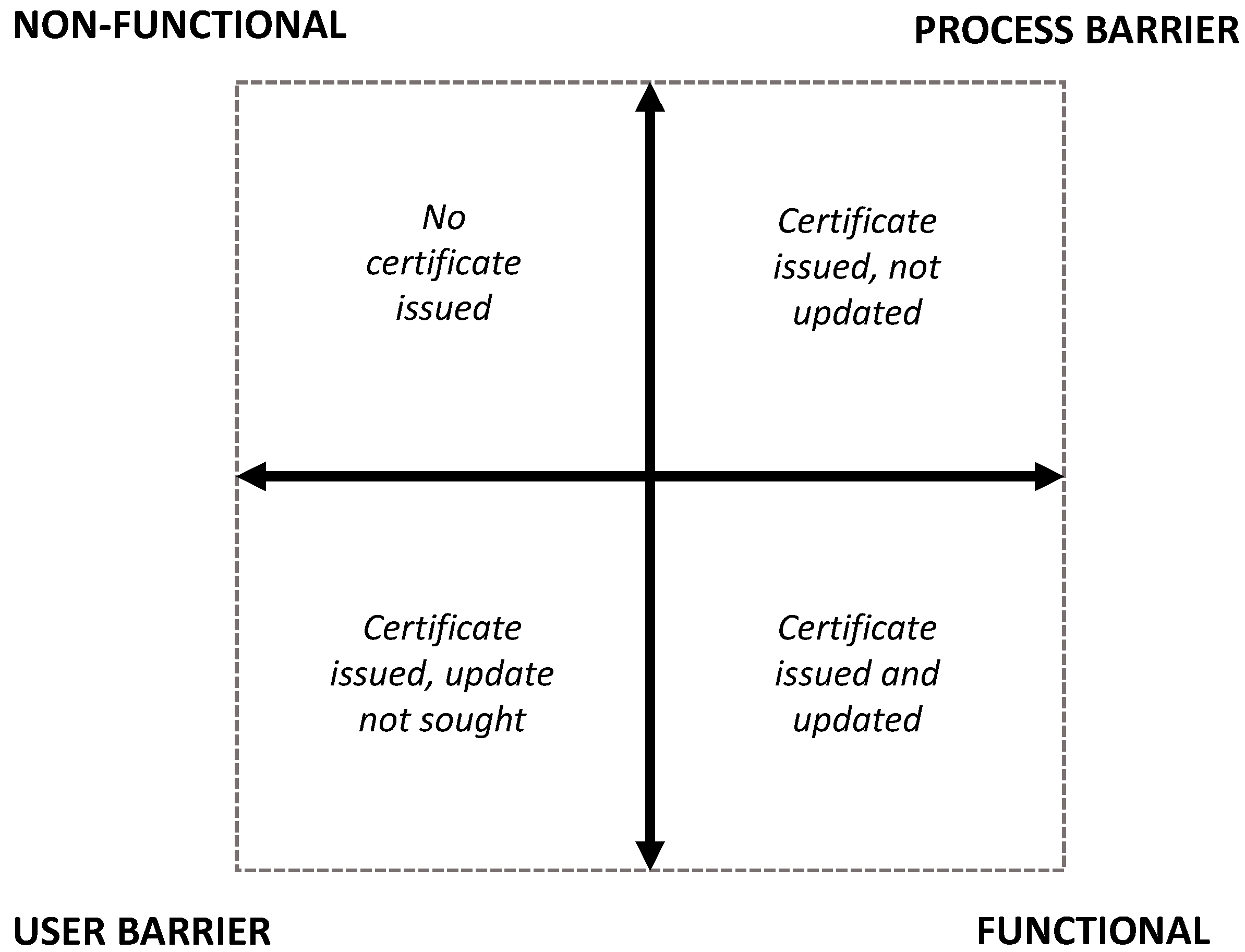
Figure 2.
Selected Woredas in Amhara Regional State.
© 2019 by the authors. Licensee MDPI, Basel, Switzerland. This article is an open access article distributed under the terms and conditions of the Creative Commons Attribution (CC BY) license (http://creativecommons.org/licenses/by/4.0/).
Share and Cite
MDPI and ACS Style
Cochrane, L.; Hadis, S. Functionality of the Land Certification Program in Ethiopia: Exploratory Evaluation of the Processes of Updating Certificates. Land 2019, 8, 149. https://doi.org/10.3390/land8100149
AMA Style
Cochrane L, Hadis S. Functionality of the Land Certification Program in Ethiopia: Exploratory Evaluation of the Processes of Updating Certificates. Land. 2019; 8(10):149. https://doi.org/10.3390/land8100149
Chicago/Turabian StyleCochrane, Logan, and Sebsib Hadis. 2019. "Functionality of the Land Certification Program in Ethiopia: Exploratory Evaluation of the Processes of Updating Certificates" Land 8, no. 10: 149. https://doi.org/10.3390/land8100149
Note that from the first issue of 2016, this journal uses article numbers instead of page numbers. See further details here.