
Article

Incremental Extensional Breakup of Western Gondwana: A Permian–Cretaceous Sedimentary Record from the Bolivian Andes of West-Central South America

1
Bureau of Economic Geology, Jackson School of Geosciences, University of Texas at Austin, Austin, TX 78758, USA
2
Department of Earth and Planetary Sciences, Jackson School of Geosciences, University of Texas at Austin, Austin, TX 78712, USA
3
Institute for Geophysics, Jackson School of Geosciences, University of Texas at Austin, Austin, TX 78712, USA
4
Department of Geosciences, Idaho State University, Pocatello, ID 83209, USA
5
Instituto de Investigaciones Geológicas y Medio Ambiente (IGEMA), Universidad Mayor de San Andrés, La Paz P.O. Box 12958, Bolivia
6
New Mexico Bureau of Geology and Mineral Resources, Socorro, NM 87801, USA
*
Author to whom correspondence should be addressed.
Stratigr. Sedimentol. 2026, 1(1), 3; https://doi.org/10.3390/stratsediment1010003
Submission received: 4 February 2026 / Revised: 24 March 2026 / Accepted: 30 March 2026 / Published: 17 April 2026

Abstract

Investigation of deposystems, sediment routing, and basin architecture during Gondwana breakup refines understanding of Permian–Cretaceous landscape evolution in the central Andes. New chronostratigraphic and provenance constraints from the Eastern Cordillera and Subandean Zone of Bolivia (19–22°S) are based on U-Pb geochronology of detrital and volcanic zircons and 40Ar/39Ar dating of interbedded basalts. A discontinuous <2 km-thick Permian–Cretaceous succession records deposition in fluvial, lacustrine, alluvial fan, eolian, and shallow marine environments. Stratigraphic correlations indicate alternations between isolated half-graben subbasins and regional, non-compartmentalized basins. Detrital zircon age spectra from 18 sandstones document sediment recycling from western orogenic and magmatic arc sources and eastern cratonic basement. Synextensional successions of Early Triassic, Early Jurassic, and mid-Cretaceous age were sourced mainly from the west, including Carboniferous and Devonian rocks, while post-extensional fluvial and eolian systems were derived chiefly from the eastern craton. Variations in thickness, facies, and mafic magmatism reflect alternating extensional and neutral tectonic regimes, with localized synextensional subsidence potentially linked to extensional collapse, mantle plume activity, and South Atlantic opening. Comparison with Andean regions in Peru and Argentina indicates that episodic extension and post-extensional thermal subsidence accompanied subduction along the western margin of South America during Gondwana-Pangea breakup.

1. Introduction

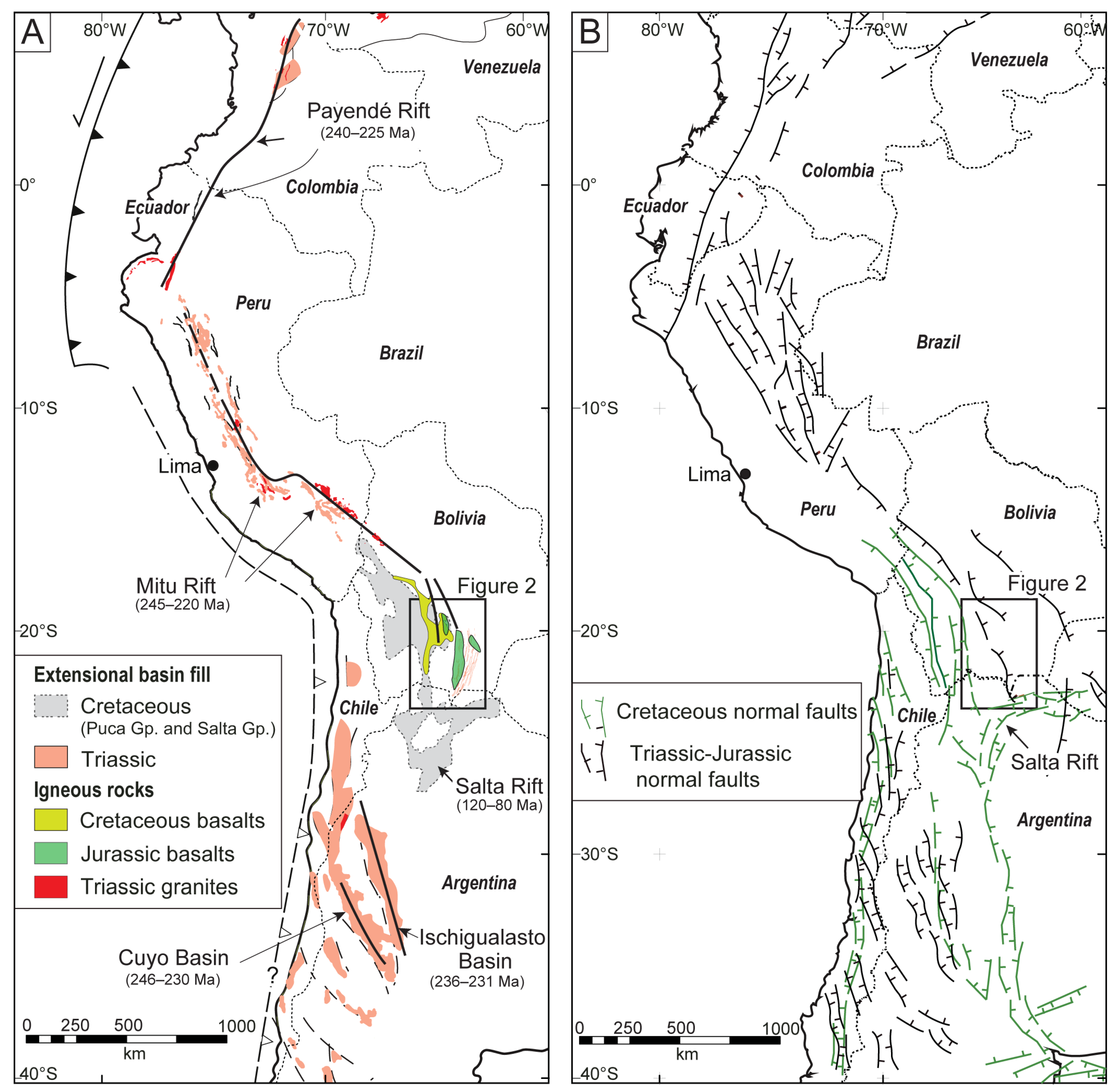
In South America, sedimentary and volcanic archives of the progressive extensional breakup of the western Gondwanan segment of the Pangea supercontinent recorded multiple Permian to Cretaceous phases, culminating in the opening of the South Atlantic at ca. 130–120 Ma. Incremental extension affected large swaths of the South America plate, including not only the eastern passive margin but also the western subduction margin (Figure 1) that was later subjected to Andean mountain building from Late Cretaceous to present [1,2,3,4,5,6].
The Permian to Cretaceous geologic record of central Andes provides a critical benchmark in understanding the evolution of western South America prior to Cenozoic construction of the Andean orogenic system. Although long-lived subduction of an east-dipping oceanic slab has persisted throughout Mesozoic–Cenozoic time, the overriding South American plate has experienced a diverse range of tectonic regimes, including contraction, extension, strike-slip, and neutral conditions [14,15]. For the northern and southern Andes, a clear record of pre-Andean extension and post-extensional thermal subsidence governed much of the Permian to Early Cretaceous history of backarc subsidence and sedimentation [16,17,18,19,20].
The central Andes, however, contain an enigmatic history that has proven challenging for researchers attempting to link pre-Andean sedimentary processes to regional tectonics [8,21,22,23,24]. Many uncertainties derive from: (1) inadequate stratigraphic age control for the largely nonmarine pre-Cenozoic successions; (2) incomplete understanding of original sediment source regions and sediment routing systems; and (3) limited constraints on the overall basin architecture and relationship to syn-sedimentary structures.
This paper seeks to address these issues for the pre-Andean stratigraphic record preserved along the Pacific margin in the central Andes of Bolivia. Here, we present the results of a field-based investigation of the Permian–Cretaceous clastic deposystems, stratigraphic framework, and basin architecture in the Eastern Cordillera and Subandean Zone at 18–22°S. These findings are integrated with chronostratigraphic and provenance constraints provided by new zircon U-Pb geochronological results for detrital materials and 40Ar/39Ar ages for interbedded igneous units.

2. Geologic and Stratigraphic Framework

A long-lived east-dipping subduction zone has defined the Pacific western margin of South America since Permian–Triassic time [25,26,27]. However, contrasting upper crustal tectonic regimes include late Paleozoic–Mesozoic low-magnitude extension, strike-slip, and neutral stress conditions followed by large-scale Cenozoic shortening and growth of the Andes [28,29,30,31,32,33]. This study addresses the polyphase extensional breakup of western Gondwana as recorded in the Permian to Cretaceous stratigraphic record of west-central South America.
In western Argentina and Chile (Figure 1), extensive bimodal magmatic rocks (Choiyoi Group), nonmarine deposits, and younger alkaline basalts were associated with Permian–Triassic orogenic collapse and rifting [34,35,36]. In southern Peru (Figure 1), clastic deposits of the Mitu Group were intruded by bimodal rhyolitic and basaltic rocks assigned to Permian–Triassic backarc extension [8,37,38] and/or inboard arc magmatism due to subduction erosion or slab shallowing [39,40]. Comparable Triassic plutons and sporadic basalts in the Eastern Cordillera of northern Bolivia [8,41] suggest a shared tectono-magmatic setting involving extension along most of the western margin of South America. Subsequent Jurassic arc magmatism in southern Peru and northern Chile yielded mafic to intermediate rocks with depleted mantle signatures consistent with discontinuous extension or transtension [16,42,43].
Final breakup of Gondwana during mid-Cretaceous opening of the South Atlantic Ocean can be temporally correlated with synextensional and post-extensional (thermal sag) basins in west-central South America, including Bolivia, Chile, southern Peru, and western Argentina [9,13,44,45,46,47]. Thereafter, an eastward advance of Cretaceous–Paleogene arc magmatism accompanied a shift to regional compression or transpression [4,31,48,49]. In southern Bolivia and northern Argentina, many inherited basement structures (Figure 1B) have been overprinted by later Andean shortening and an eastward progression of arc magmatism [38,50,51,52]. In this sense, the age and architecture of Paleozoic–Mesozoic sedimentary basin fill and related structures associated with incremental breakup of western Gondwana are particularly valuable in assessing the influence of tectonic inheritance on the construction of the modern Andes [13,53,54,55].
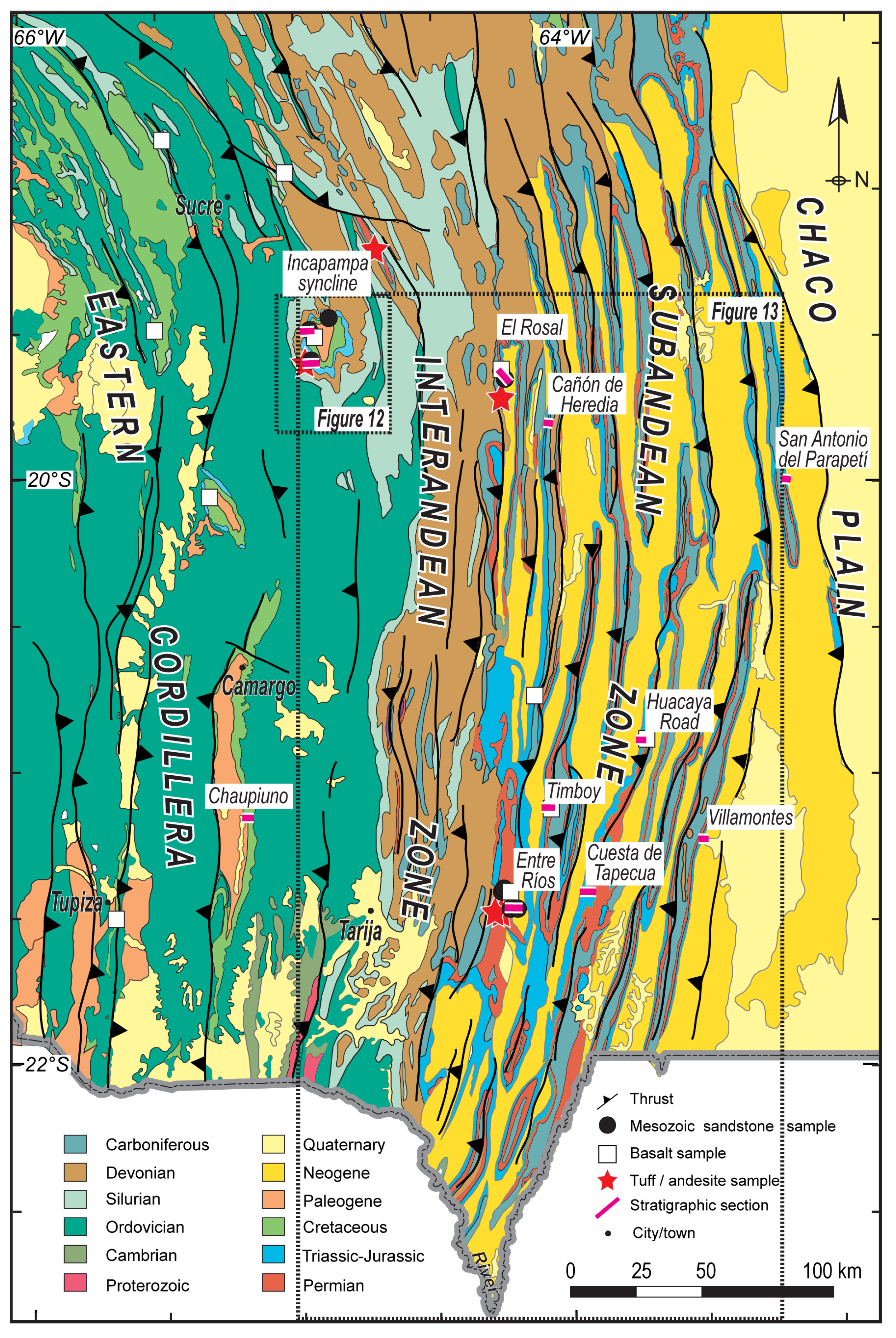
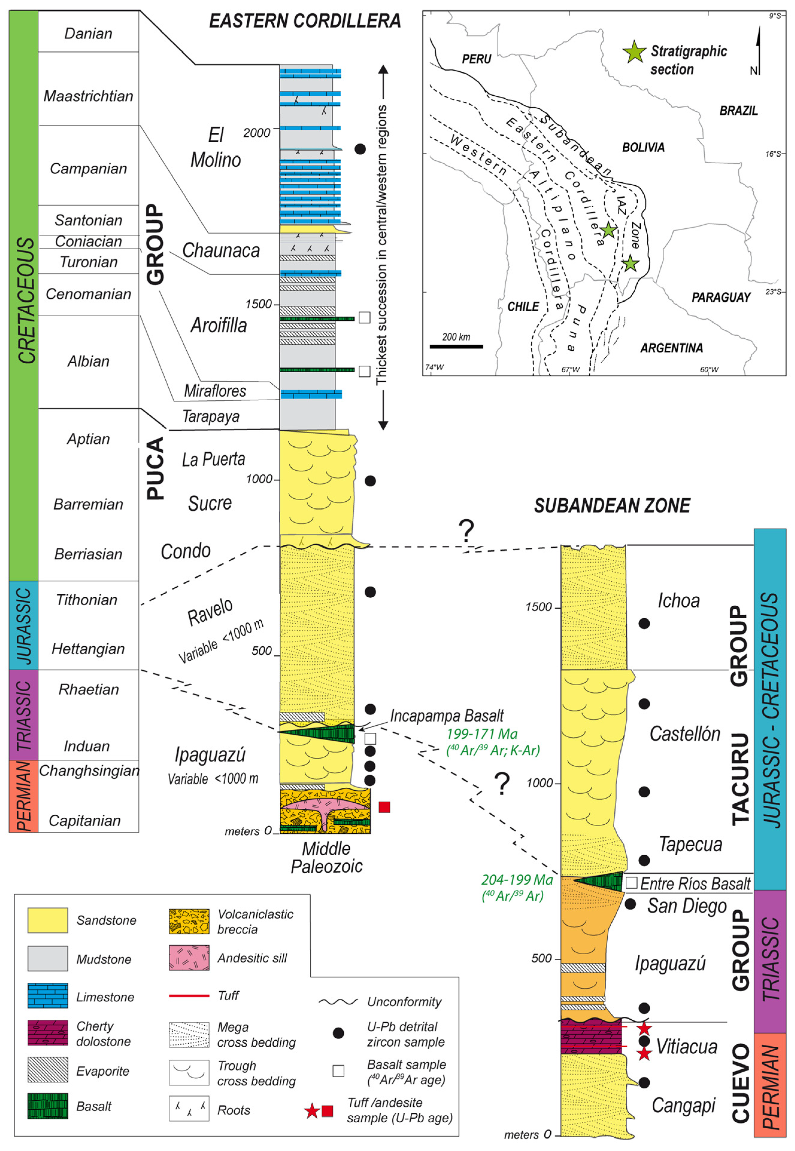
A discontinuous upper Paleozoic through Mesozoic stratigraphic record spans retroarc regions of the central Andes (Figure 2). In Bolivia, the Subandean Zone and Eastern Cordillera provide complementary sedimentary records, but with limited chronostratigraphic constraints. The deposits for these two provinces in southern Bolivia are described below, respectively, from lower to upper stratigraphic levels.
In the Subandean Zone (Figure 2), a poorly dated, <2 km thick Permian to Cretaceous succession consisting of principally nonmarine clastic sedimentary rocks and interbedded volcanic horizons caps a glacial-influenced Carboniferous interval (Figure 3). Overlying the Carboniferous section, the Permo–Triassic Cuevo Group is represented by the Cangapi, Vitiacua, Ipaguazú, and San Diego Formations. In lower levels, the Permian Cangapi Formation (<300 m thick) is represented by eolian and fluvial sandstone with subordinate siltstone and limestone. Although a lack of fossils hinders chronostratigraphic assignments, this unit is considered partially correlative to the Permian Copacabana, Chutani, and Vitiacua Formations [21,22,57,58,59,60]. Upsection, the shallow marine Vitiacua Formation (<200 m thick) contains interbedded limestone, dolostone, chert, shale, and sandstone (Figure 3). Palynological assemblages suggest that Vitiacua deposition coincided with the Lower Permian Copacabana Formation [61]. The Triassic Ipaguazú Formation (up to 450 m thick), composed of mostly lacustrine sandstone, siltstone, and evaporites, is overlain by fluvio-eolian sandstones of the San Diego Formation (<100 m thick). The tholeiitic Entre Ríos basalt (<120 m thick) unconformably overlies older units with most 40Ar/39Ar and K-Ar ages spanning from Late Triassic to Early Jurassic (ca. 204 to 199 Ma) [12,22,57,62,63]. The unconformably overlying Jurassic–lowermost Cretaceous Tacurú Group includes the Tapecua, Castellón, and Ichoa Formations. The Tapecua Formation (>200 m thick) has a basal pebble conglomerate that grades into fluvial and eolian sandstones, followed by the Castellón Formation (>700 m thick) composed of trough cross-stratified sandstone, shale, and local marl. The capping Ichoa Formation (<600 m) unconformably overlies the Castellón or older Paleozoic units and is composed of eolian sandstones [64]. Paleontological constraints on the Tacurú Group remain limited. Conchostracans from the Castellón Formation suggest a debated Early Cretaceous age [65], while sauropod tracks (ichnites) from the same unit, above the Entre Ríos basalt, indicate a Jurassic to earliest Cretaceous age [66].
The corresponding record in the Eastern Cordillera (Figure 2) lacks upper Paleozoic strata and is limited to isolated Triassic–Jurassic fluvial, lacustrine, and eolian deposits with interbedded basalts (Chutani, Tiquina, Sayari and Ravelo Formations) overlain unconformably by a Cretaceous succession (Puca Group) of variable thickness (Figure 3) [8,11,41,46,62,67]. At Incapampa, dinosaur ichnological records preserved in red beds beneath the Incapampa basalt constrain the Ipaguazú (Sayari) Formation to a Middle–Late Triassic age [68]. The base of the Cretaceous Puca Group is defined by an angular unconformity in which chiefly Ordovician marine rocks are capped by Cretaceous alluvial fan and fluvial deposits (Condo, La Puerta, and Sucre Formations) intruded by alkaline sills and dikes [11,46,69]. Upsection, mudrock and local evaporites of the <100 m thick Tarapaya Formation are overlain by <50 m thick fossiliferous marine limestone of the Cenomanian–Turonian Miraflores Formation [46,70]. Renewed mafic magmatism accompanied mudrock and evaporite deposition of the Aroifilla Formation (>500 m thick) and sandstone, marl, and limestone of the Chaunaca Formation and correlative sand-rich Torotoro Formation (>200 m thick). The Eastern Cordillera succession is capped by the uppermost Puca Group, defined by the Maastrichtian–Paleocene El Molino Formation (>500 m thick), which consists of fossiliferous limestone, calcareous sandstone and marl of lacustrine or shallow-marine origin [71,72,73].

3. Depositional Systems

3.1. Methods

A series of principally nonmarine depositional systems are responsible for the <2 km thick Permian–Cretaceous stratigraphic record in the Subandean Zone and Eastern Cordillera (Figure 3). Measured stratigraphic sections along two transects (19°S and 21°S) include lithofacies identifications, paleoflow measurements, and new 40Ar/39Ar and U-Pb age constraints from volcanic and sedimentary rocks (Figure 4). These results indicate unsteady deposition involving: (1) Permian fluvial, eolian, and shallow marine systems (Cangapi and Vitiacua Formations); (2) Triassic alluvial fan, braided to sheetflow fluvial, and lacustrine systems (Ipaguazú Formation); (3) Jurassic eolian, lacustrine, and distal overbank fluvial systems (Tapecua, Castellón, and Ravelo Formations); and (4) Cretaceous lacustrine, fluvial, and alluvial fan systems (Ichoa, Condo, La Puerta, Sucre, Tarapaya, Miraflores, Aroifilla, Chaunaca, and El Molino Formations). Sedimentological characterization of facies associations and interpretations of depositional environments (Figure 5; Table 1) are based on eight measured sections (Figure 4).
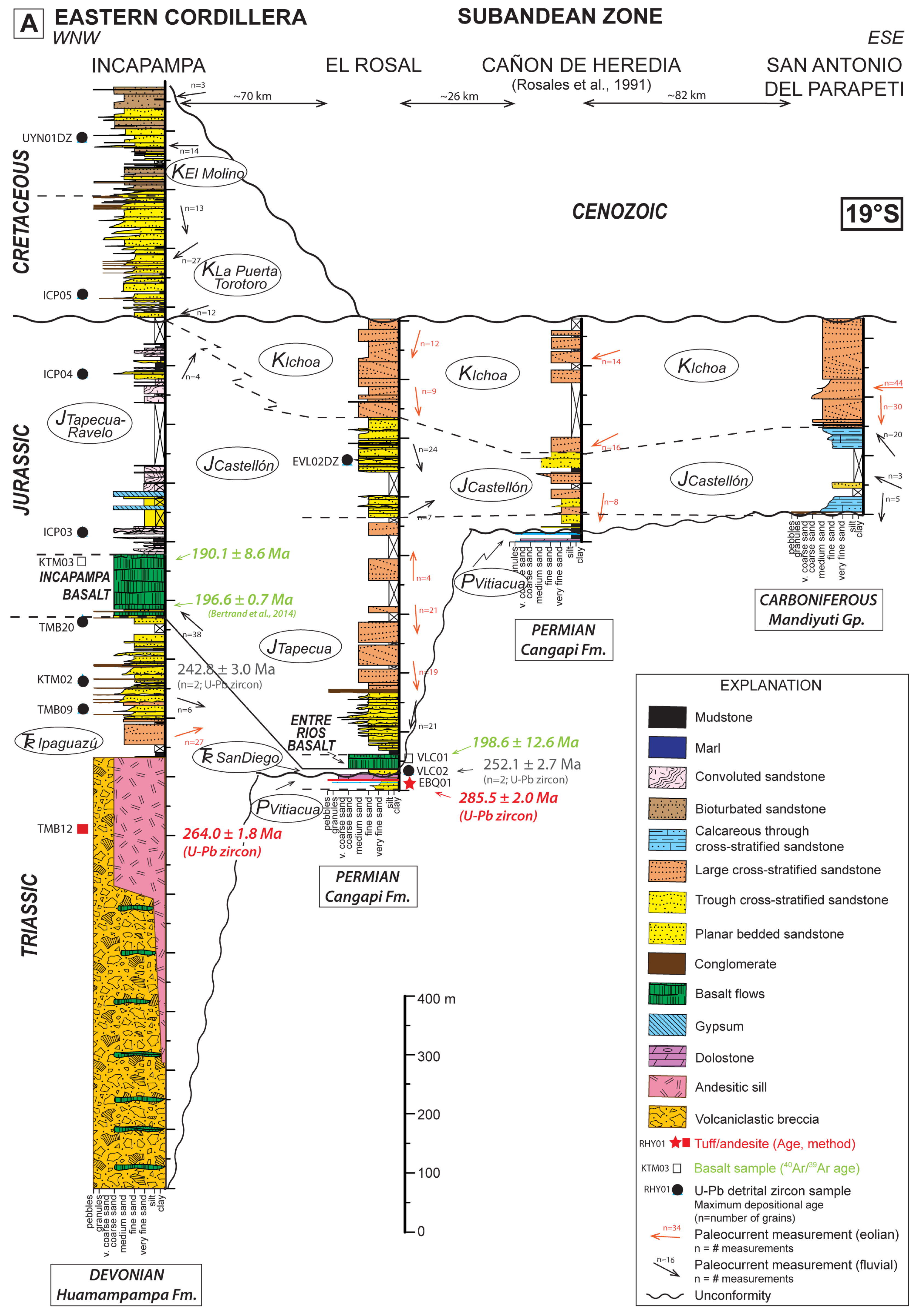
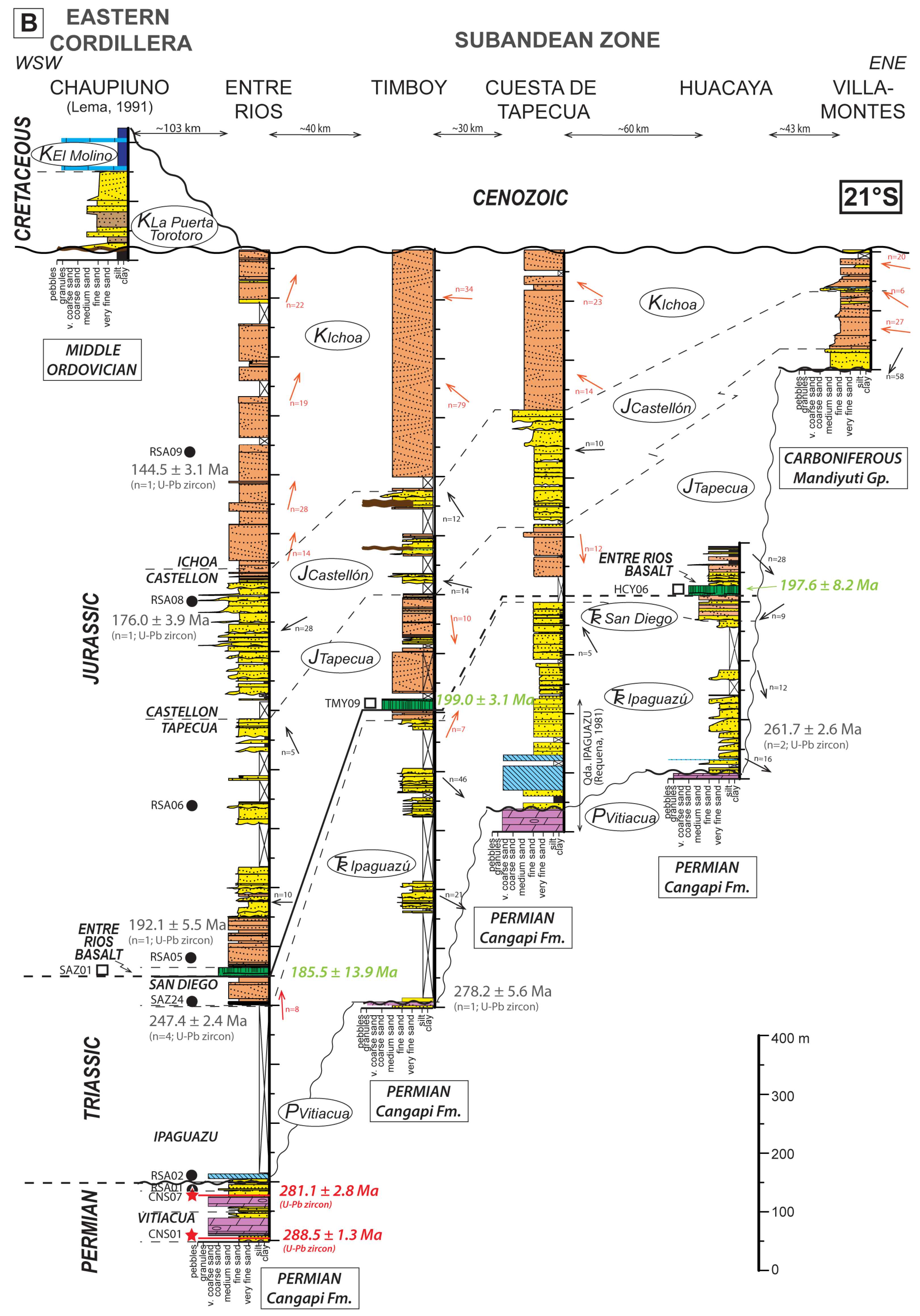
Figure 4. Stratigraphic sections of Permian–Cretaceous units and regional correlations across the Eastern Cordillera and Subandean Zone at (A) 19°S, and (B) 21°S. Measured sections (see Figure 2 for locations) show lithofacies, sample locations, 40Ar/39Ar and U-Pb ages of igneous rocks, detrital zircon U-Pb maximum depositional ages, and paleoflow and paleowind directions. We include prior measured sections from [74,75,76] and a prior 40Ar/39Ar age from [77]. Rock units are shown in ovals and subcrop units for each section are shown in boxes. The reported spacing (in km) among sections reflects horizontal distances orthogonal to regional Andean strike. Variations in thickness and lithofacies highlight Lower Triassic and Lower Jurassic fluvial-alluvial fan wedge geometries overlapped by regionally extensive Jurassic to Lower Cretaceous fluvio-eolian units. Stratigraphic age abbreviations: P = Permian; Tr = Triassic; J = Jurassic; K = Cretaceous.
Stratsediment 01 00003 g004aStratsediment 01 00003 g004b
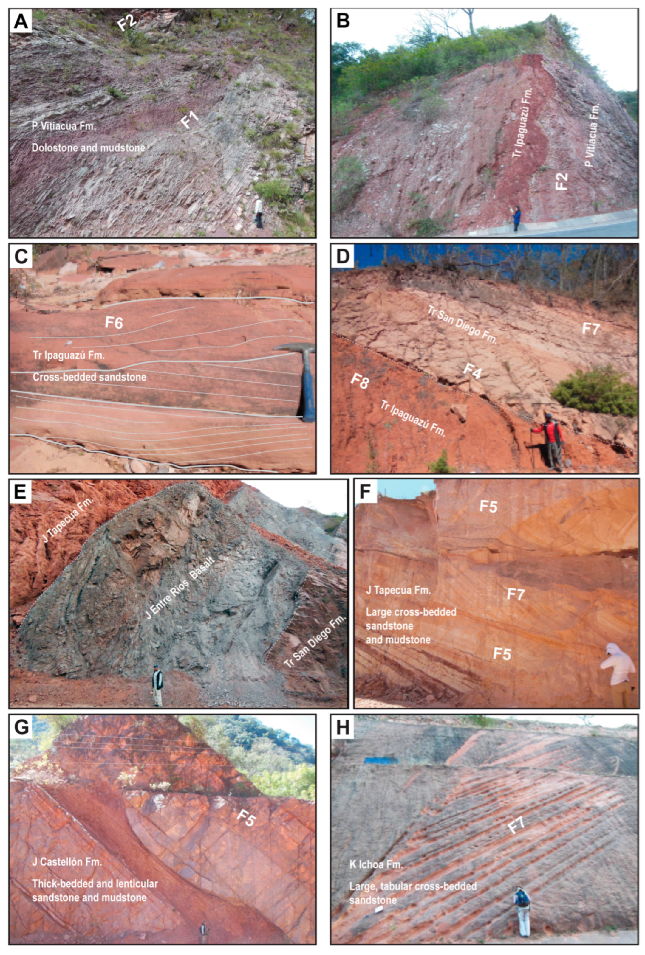
Figure 5. Photos of representative lithofacies of Permian–Cretaceous basin fill in the Subandean Zone, including facies association codes (Table 1). (A) Thin-bedded cherty dolostones, mudstones, and sandstones of the Permian Vitiacua Formation. (B) Clay-rich red sandstones and white gypsum boulders of the Triassic Ipaguazú Formation unconformably capping dolostones and sandstones of the Vitiacua Formation (Entre Ríos section). (C) Trough cross-stratified sandstones of the Ipaguazú Formation (Timboy section). (D) Structureless, clay-rich sandstones of the Ipaguazú Formation overlain by fluvial and eolian sandstones of the Triassic San Diego Formation (Huacaya section). (E) Type section of the Jurassic Entre Ríos basalt, highlighting sharp contacts with the underlying San Diego Formation and overlying Jurassic Tapecua Formation (Entre Ríos section). (F) Interbedded thin-bedded sandstones and mudstones capped by thick cross-stratified sandstones of the Tapecua Formation (El Rosal section). (G) Thick-bedded tabular and lens-shaped sandstones and mudstones of the Jurassic Castellón Formation (Entre Ríos section). (H) Very thick, cross-bedded eolian sandstones of the Cretaceous Ichoa Formation (Villamontes section). Stratigraphic age abbreviations: K = Cretaceous; J = Jurassic; Tr = Triassic; P = Permian.
Stratsediment 01 00003 g005
Table 1. Facies characteristics of Permian–Cretaceous sedimentary rocks in southern Bolivia modified from [78,79,80,81,82].
Facies AssociationsDiagnostic FeaturesDepositional ConditionsStratigraphic Units
Carbonate Ramp (F1, F2)
F1: Tidal-supratidal complex (inner carbonate ramp) depositsPlanar-laminated carbonate mudstone grading upward to thin- to medium-bedded tabular dolostone and minor oolitic or peloidal grainstone replaced by dolomite (Figure 5A,B); arranged in upward-shallowing cycles (<2 m thick). Irregular wavy-bedded sandstone beds (<3 cm thick) alternating with organic-rich silstone (<1 cm thick) and chert nodules.Mixed high- and low-energy carbonate accumulation (locally evaporitic) with limited clastic input on inner carbonate ramp.Vitiacua Fm.
F2: Shoal to lower shoreface (inner to middle carbonate ramp) depositsLow-angle to tabular cross-bedded sandstone (Figure 5A,B). Well-sorted, quartz-rich sandstone beds (0.2–0.4 m thick) commonly have scoured bases with broadly lenticular geometries.2D dunes within shallow channels associated with clastic input from tidal and storm currents.Vitiacua Fm.
Alluvial Fan (F3)
F3: Debris flow depositsCrudely bedded (<2 m thick), disorganized, matrix-supported cobble-boulder breccias intercalated with laterally discontinuous, structureless sandstone (0.2–0.8 m thick) (Figure 6B). Deposits are poorly sorted, exhibit poor to reverse grading, contain few sedimentary structures (rare horizontal stratification), and exhibit internal folds and faults.Debris flow deposition on alluvial fans or talus cones.Ipaguazú Fm.
Fluvial (F4–F6)
F4: Sheetflow fluvial depositsLaterally continuous fine-grained sandstone and siltstone beds (0.1–0.4 m thick), with horizontal stratification, current and climbing ripples, minor contorted laminations, and desiccation cracks (Figure 5D and Figure 6C,D).Unconfined water flow deposition in fluvial or alluvial fan environments.Ipaguazú, San Diego Fms.
F5: Braided fluvial depositsUpward-fining, imbricated pebble conglomerate, trough cross-stratified sandstone, and ripple- and planar-laminated mudstone with local desiccation cracks, arranged in <5 m thick cycles (Figure 5C,F and Figure 6C,G,H). Pedogenic concretions and calcareous nodules cap cycle locally, with pervasive bioturbation and paleosols in selected zones (e.g., upper Torotoro and El Molino Formations) (Figure 6H).3D dunes, channel bars, and limited overbank deposition in braided fluvial settings.Ipaguazú, San Diego, Tapecua, Castellón, Torotoro, El Molino Fms.
F6: Meandering fluvial depositsSandstone and subordinate conglomerate beds organized into upward-fining lateral accretion packages (0.5–2.5 m thick). Moderately incised basal scour surfaces are capped by trough cross-stratified and ripple cross-stratified sandstone (Figure 5C,G). Separate intervals include thin-bedded horizontal to ripple cross-stratified sandstone and laminated mudstone.2D and 3D dunes in point bars, and crevasse splay and suspension settling in floodplains of meandering fluvial systems.Ipaguazú Fm.
Eolian (F7)
F7: Eolian dunes and sand sheet depositsWell sorted, very thick-bedded (>1–5 m), tabular and trough cross-stratified sandstone exhibiting tangential foresets (Figure 5E,H and Figure 6A,F), with locally interbedded structureless, horizontally stratified, and ripple cross-laminated sandstone beds. Pervasive pedogenic carbonate nodules and rhyzoliths (<5 m thick) occur locally (e.g., top of Ichoa Formation).Eolian deposition of large sand dunes and wind ripples in dune fields and interdune areas.San Diego and Ichoa Fms., discrete intervals in Tapecua and Castellón Fms.
Lacustrine (Playa) (F8)
F8: Evaporative mudflats and playa (salt pan) depositsAlternating thin-bedded mudstone, calcareous sandstone, and gypsum, with local bioturbation, calcareous nodules, cobbles and boulders of gypsum and halite, and penetrative gypsum veinlets that cut across bedding. Sedimentary structures include horizontal lamination, wavy to contorted beds with soft-sediment deformation and water-escape structures. (Figure 5D and Figure 6D,E)Evaporative precipitation and intermittent mud and sand deposition in saline mudflats and salt pans.Ipaguazú Fm., Tacurú Gp.

3.2. Subandean Deposystems

In the Subandean Zone, fluvial-eolian sandstones of the Lower Permian Cangapi Formation are succeeded by the Vitiacua Formation [8,21,22], which consists of laterally continuous carbonate mudstones that grade upward into thin-bedded dolostones and lenticular sandstones with chert nodules and sparse oolitic limestones (Figure 5A). These shallow-marine assemblages represent tidal-supratidal deposition along a carbonate ramp (F1, F2, Table 1). New U-Pb igneous age constraints for the Vitiacua Formation available from four partially reworked tuffs (Figure 3 and Figure 4) confirm Early Permian maximum depositional ages.
In the Subandean Zone, the overlying Triassic Ipaguazú Formation exhibits a basal erosional contact distinguished by poorly consolidated red sandstone and conglomerate with cobbles to boulders of gypsum and halite (Figure 5B). The upper Ipaguazú is dominated by trough cross-stratified sandstone and 0.5–2.5 m thick lateral accretion sets with <0.5 m relief erosional surfaces overlain by tabular fine-grained sandstones to mudstones (F6, Table 1; Figure 5C). Whereas the lower Ipaguazú is attributed to shallow lacustrine (playa) deposition (F8, Table 1), the upper levels represent shallow channel, point bar, levee, and overbank meandering fluvial deposits of a distal fluvial megafan (F4, F6, Table 1). Upsection, medium- to coarse-grained sandstones of the Triassic San Diego Formation (20–100 m thick) overlie an erosional unconformity capping the Ipaguazú and Vitiacua Formations (Figure 5D). Trough cross-stratified and planar-laminated sandstones document braided to ephemeral sheetflow fluvial environments (F4, F5, Table 1) that transition upward into >2 m thick cross beds indicative of eolian dune deposition (F7, Table 1; Figure 5D). The San Diego Formation is capped by the regionally extensive, <120 m thick Entre Ríos basalt (Figure 5E), which is overlain unconformably by the Jurassic–lowermost Cretaceous Tacurú Group, including the Tapecua, Castellón, and Ichoa Formations.
Subandean exposures of the Tapecua Formation include a basal <2 m pebble-cobble conglomerate, with clasts of the underlying Entre Ríos basalt, overlain by >50 m of sandstone and mudstone. Trough and ripple cross stratification, rip-up clasts, mudcracks, and thin paleosols are common. Well-sorted, wedge-shaped sandstones containing tabular and/or trough cross stratified sets up to 2 m thick (Figure 5F) demarcate alternating eolian and fluvial braided to overbank conditions (F5, F7, Table 1). The type section of the Castellón Formation (at Entre Ríos) consists of sandstones and mudstones (Figure 5G) with a basal conglomerate that fills >1 m relief erosional surfaces with granule-pebble lenses of quartz arenite and vein quartz clasts. The main body of the Castellón contains tabular, laterally persistent, trough-cross stratified, medium- to fine-grained sandstones that transition into alternating tabular, thin-bedded, fine-grained sandstones and mudstones. Mudcracks, planar lamination, ripples, and rootlets are common. These deposits are interpreted as braided channel and overbank fluvial deposits (F5, Table 1). The overlying Ichoa Formation records the return of >2 m thick tabular and trough cross-stratified sandstones along with granule-pebble conglomerate sheets. These facies indicate the establishment of an extensive desert environment dominated by dune fields with minor interdune fluvial and pedogenic conditions (F7, Table 1; Figure 5H).

3.3. Eastern Cordillera Deposystems

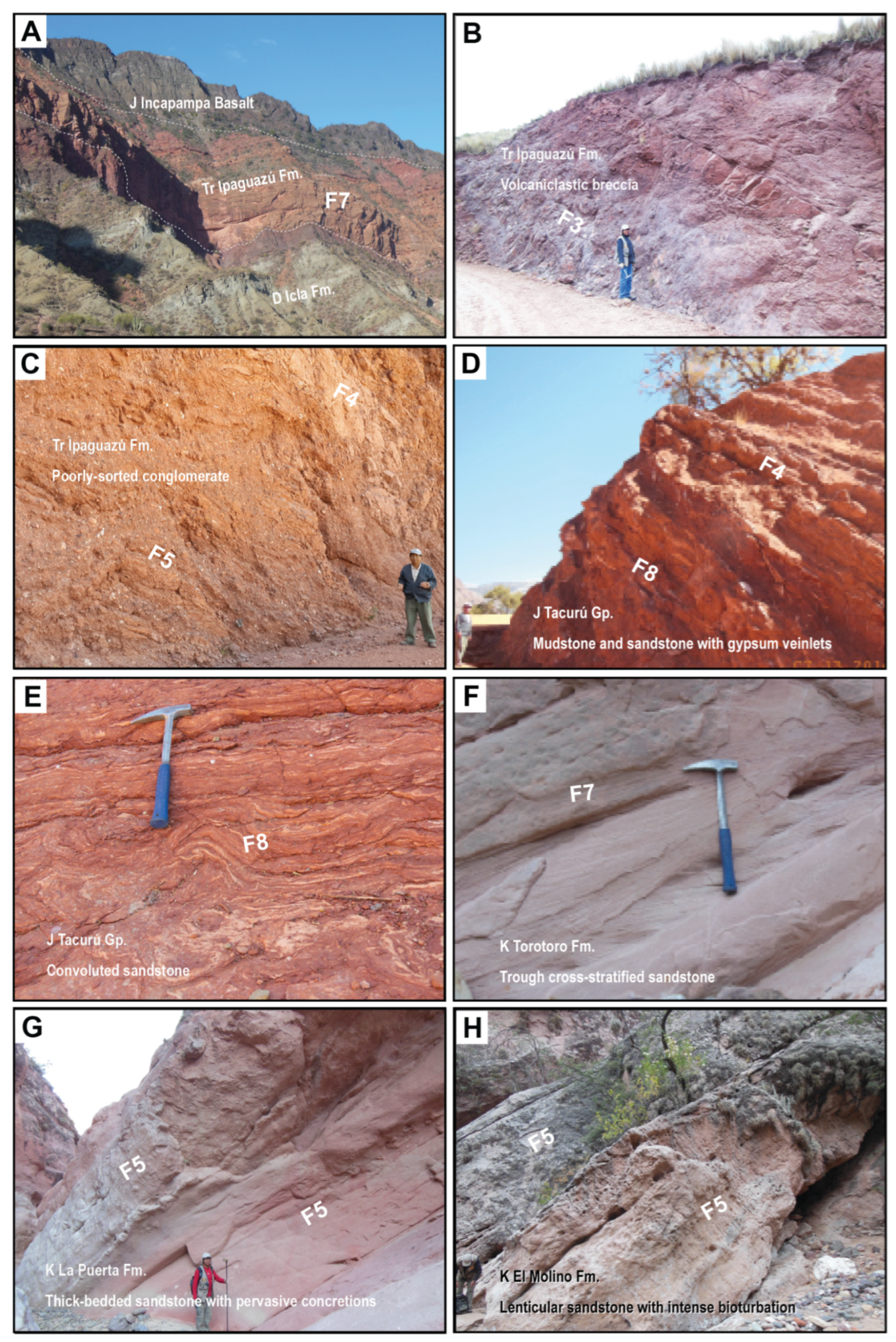
In contrast with the Subandean Zone, Triassic to Early Cretaceous deposition of the Ipaguazú Formation and Tacurú Group in the Eastern Cordillera involved distinctively coarser lithofacies with interbedded igneous units (Figure 6A). Triassic deposits of the basal Ipaguazú Formation include interbedded matrix-supported, cobble-boulder breccias and tabular sandstones (Figure 6B; Table 1), with diverse clasts of basalt, porphyritic andesite, Devonian sandstone, and Permian chert and fossiliferous limestone (including brachiopods of Dictyoclostus sp.; Olga Zalles (pers. comm.). Igneous intervals consist of several <40 m thick basalts and porphyritic andesites with interbedded breccias showing limited sedimentary structures and local reverse grading (Figure 6B). These volcaniclastic lithofacies are attributed to debris flow and sheetflow processes on alluvial fans or talus cones proximal to volcanic sources or igneous centers (F3, F4, Table 1; e.g., [83]). Upsection, the middle Ipaguazú contains 0.4–1.5 m-thick tabular, lithic-rich sandstones that grade into moderately organized pebble conglomerates (Figure 6C) with >1 m thick cross-stratified sandstones. The upper Ipaguazú includes braided fluvial and sheetflow deposits of a terminal fluvial megafan associated with eolian dune fields (F4, F5, F7, Table 1; e.g., [84]). The top of the Incapampa-Uyuni basalt (Figure 6A) marks the base of the Tacurú Group in the Eastern Cordillera, where it contains poorly sorted, muddy to coarse-grained sandstones, along with isolated gypsum boulders and penetrative gypsum veinlets (Figure 6D). Contorted bedding, mudcracks, incipient paleosols, and ripple cross-lamination (Figure 6E) attest to evaporative lacustrine (playa) depositional conditions (F8, Table 1).
Across most of the Eastern Cordillera, Mesozoic eolian sandstones of the Ravelo Formation unconformably overlap lower Paleozoic strata. Multistory Ravelo sandstone bodies are composed of large-scale trough cross strata displaying 2–20 m set thicknesses and large foresets with tangential bases. Correlations with Subandean eolian facies of the Tacurú Group (including the Tapecua and Ichoa Formations) in Bolivia and northernmost Argentina [21] point to a regional eolian dune field, likely spatially linked with extensive Mesozoic dune fields across southwestern Gondwana such as the Botucatu Formation of the Paraná Basin, Brazil [85,86].
The Ravelo eolianite is capped by variable local facies of the Cretaceous lower Puca Group (Condo, La Puerta, and Sucre Formations), in which basal conglomerates are capped by tabular sandstones and mudstones. The disorganized pebble-cobble conglomerates and trough cross-stratified sandstones with erosional scour surfaces (Figure 6F) are consistent with braided fluvial and localized alluvial fan deposition (F3, F4, F5, Table 1). This coarse-grained basal interval with sharp facies variations (lower Puca Group) is overlain by a regionally uniform mudstone-rich section (middle and upper Puca Group) defined by the Tarapaya, Miraflores, Aroifilla (Torotoro), Chaunaca, and El Molino Formations. These Cretaceous units are dominated by laterally continuous claystone, siltstone, and thin sandstone beds with horizontal laminations, ripple marks, bioturbation, and calcareous nodules. A gray siltstone processed for fossil pollen was barren, but shallow marine fossils indicate a Cenomanian–Turonian age for the Miraflores Formation. The major facies are ascribed to shallow lacustrine and overbank fluvial settings marked by crevasse splay deposition and pedogenesis with limited fluvial channels (F5, F8, Table 1; Figure 6G). In uppermost levels of the Puca Group, the El Molino Formation is defined by carbonates, laminated shales, and local pebbly sandstones with ripple marks, bioturbation, and dissolution features (stylolites). At the top, calcareous sandstones fill erosional surfaces (Figure 6H) with pervasive burrows that resemble termite nests (Krausichnus trompitus), reported from the Paleogene Cayara Formation [87]. The mixed carbonate and clastic deposits of the El Molino Formation represent the easternmost lacustrine or marine transgressive deposits during a Maastrichtian–early Paleocene highstand, with linkages to flanking sandy beach or braided fluvial systems (F5, Table 1).

4. Stratigraphic Correlations and Sediment Routing

4.1. Methods

The Permian–Cretaceous stratigraphic record of southern Bolivia (Figure 2 and Figure 3) reflects a combination of compartmentalized deposition related to tectonic processes and post-deformational deposition of more-regional extent. New age constraints for eight measured sections (7.6 km total thickness), organized into two east-west transects at 19°S and 21°S, facilitate chronostratigraphic correlations between the Eastern Cordillera and Subandean Zone (Figure 4). Correlations are aided by the inclusion of two previously reported stratigraphic sections [74,75], with the base of the Cenozoic interval chosen as the regional tie horizon. The contrasting stratigraphic framework among separate depocenters elucidates the pre-Cenozoic stratigraphic and structural configuration during proposed extensional (synrift) to post-extensional (postrift) tectonic regimes.

4.2. Regional Stratigraphic Correlation at 19°S

Along an east-west transect at 19°S (consisting of four stratigraphic sections: Incapampa, El Rosal, Cañón de Heredia, San Antonio del Parapetí), diverse stratigraphic geometries across the Subandean Zone to easternmost Eastern Cordillera range from regionally uniform (tabular) geometries to localized prisms (wedges) defined by rapid lateral thickness variations, possibly related to upper crustal structures (Figure 4A). The most pronounced changes in subcrop and thickness relationships are expressed over a ~70 km east-west distance between the Incapampa (easternmost Eastern Cordillera) and El Rosal (westernmost Subandean Zone) sections (Figure 2 and Figure 4A). Whereas a ~1000 m thick Triassic interval disconformably overlies Middle Devonian rocks in the west, this interval tapers drastically eastward to a <10 m package conformably overlying Permian rocks. A similarly sharp eastward thinning from 100 m to 25 m is recorded by Lower Jurassic basalts between these two sections. The overlying Lower Jurassic Tapecua Formation also shows regional thinning from ~400 m in the Incapampa and El Rosal sections to <20 m eastward in the Cañón de Heredia section (Figure 4A). In contrast, the Middle Jurassic–lowermost Cretaceous Castellón and Ichoa Formations exhibit a relatively tabular and regionally uniform geometry (150–300 m thick) over a ~110 km swath spanning the Subandean Zone, with eastward onlap onto progressively older Paleozoic units.
We interpret the separate localized depocenters and rapid lateral thinning within Lower Triassic and Lower Jurassic stratal assemblages (Ipaguazú and Tapecua Formations) to result from uneven subsidence driven by syndepositional normal faulting and hanging-wall tilting within half-graben systems that were broadly centered in the western Subandean Zone. This pattern, however, did not persist, and the subsequent tabular geometries and eastward onlap expressed in overlying deposits (the Middle-Upper Triassic San Diego Formation and Middle Jurassic–lowermost Cretaceous Ichoa Formations) were achieved by widely distributed, post-extensional thermal subsidence.
Farther west along the 19°S transect, the Eastern Cordillera recorded Jurassic eolian deposition of regional extent (Ravelo Formation). In contrast, the overlying Lower Cretaceous deposits of the basal Puca Group show coarse-grained facies and local thickness variations consistent with isolated subbasins. These localized Cretaceous units within the Eastern Cordillera are not readily correlated with deposits farther east in the Subandean Zone [11,46,67]. The Incapampa section (Figure 4A) preserves the easternmost deposits of the Lower Cretaceous La Puerta-Torotoro (~250 m) interval and a thin basin-margin facies (~150 m) of the uppermost Cretaceous El Molino Formation, suggesting a pronounced eastward thinning and pinchout of these units. We attribute the restricted distribution of Cretaceous units to enhanced subsidence west of the Subandean Zone, consistent with previous interpretations of localized Early Cretaceous extension in the Eastern Cordillera, similar to the Salta Rift of northern Argentina [9,10,46,47,88,89,90].

4.3. Regional Stratigraphic Correlation at 21°S

An east-west transect at 21°S (consisting of six stratigraphic sections: Chaupiuno, Entre Ríos, Timboy, Cuesta de Tapecua, Huacaya, and Villamontes) (Figure 4B) shows lateral thickness variations related to syn- and post-deformational Mesozoic sedimentation. In lower levels, the Lower Triassic Ipaguazú Formation thins eastward from >400 m to <250 m across a ~90 km east-west distance from the Timboy to Huacaya section, with complete pinchout before Villamontes, ~43 km farther east (Figure 4B). In contrast, the Middle Triassic–Lower Jurassic San Diego and Entre Ríos Formations exhibit a roughly tabular <50–100 m distribution across the Subandean Zone from Entre Ríos to Huacaya. As in the 19°S transect (Figure 4A), the Lower Jurassic Tapecua Formation shows an eastward-tapering geometry from Entre Ríos (>400 m) to Villamontes (~30 m). The Middle Jurassic–lowermost Cretaceous Castellón and Ichoa Formations also thin eastward from 750 m to 150 m, in contrast with the 19°S transect.
The two eastward tapering stratigraphic geometries represented by the Lower Triassic Ipaguazú and Lower Jurassic Tapecua Formations (Figure 4B) are linked to separate phases of asymmetric subsidence driven by extensional deformation. Both stratigraphic prisms are capped by tabular geometries of greater regional extent—including, respectively, the Middle-Upper Triassic San Diego Formation and Upper Jurassic–lowermost Cretaceous Castellón and Ichoa Formations. Similar to the regional transect at 19°S (Figure 4A), we interpret two separate phases of punctuated extension followed by regional post-extensional thermal subsidence. The narrower spatial distribution of Triassic, relative to Jurassic synrift deposits, suggest a progressive broadening of the region affected by Mesozoic extension. We ascribe fault-induced subsidence during separate phases of Early Triassic (Ipaguazú) and Early Jurassic (Tapecua) deposition to motion along east-dipping normal faults that induced enhanced accommodation along the Subandean-Eastern Cordillera transition. Such structures may represent reactivated features inherited from Paleozoic orogenesis [13,52].
Along the western part of the 21°S transect, the Eastern Cordillera contains a stratigraphic record in accordance with the previously described 19°S transect, wherein a Jurassic eolianite (Ravelo Formation) provides a regional marker unit that is succeeded by multiple Cretaceous units of the Puca Group (Figure 4B). This Jurassic–Cretaceous section consistently overlies Ordovician rocks in angular unconformity across the Eastern Cordillera, with no preservation of upper Paleozoic to Triassic strata [21,22,91]. In the Chaupiuno section (Figure 4B), a thin (~150 m) package of Lower Cretaceous La Puerta-Torotoro Formations and uppermost Cretaceous El Molino Formation tapers and pinches out eastward toward the Entre Ríos section of the Subandean Zone. We interpret this thin Cretaceous interval as the distal eastern margin of an extensional and post-extensional package that is more fully developed farther west in the Eastern Cordillera, including the northern continuation of the Salta Rift [9,11,67].

4.4. Sediment Dispersal Patterns

Sediment routing during Permian to Cretaceous deposition was governed by fluvial and eolian processes in the Eastern Cordillera and Subandean Zone of Bolivia. A total of 661 fluvial paleocurrents from trough cross strata and 527 paleowind indicators from eolian dune facies were measured at 53 stations within the measured sections (Figure 4).
Widespread Triassic fluvial systems (Ipaguazú and San Diego Formations) transported material broadly eastward, with limited eolian transport to the north and east. These trends are consistent with topographic sources to the west within the early Andean magmatic arc and present-day Eastern Cordillera, where middle to upper Paleozoic rocks were largely eroded away [21,22,91,92].
In contrast, Jurassic fluvial deposits (Tapecua and Castellón Formations of the Tacurú Group) recorded principally westward transport, with large-scale eolian dispersal largely oriented to the south. This configuration represents westward dispersal along with axial paleoflow oriented parallel to north-trending pre-Andean structures. Accumulation of extensive eolian Jurassic dune complexes within the lower-middle Tacurú Group likely accompanied erosional beveling of upper Paleozoic rocks to the east, including the Izozog structural high in the present-day Chaco Plain [93,94].
Earliest Cretaceous eolian deposition in the Subandean Zone (Ichoa Formation of the upper Tacurú Group) involved transport to the north and west, consistent with continental-scale eolian systems to the southeast in the Paraná Basin of southern Brazil (e.g., Botucatu Formation [85,86]). In the Eastern Cordillera (Incapampa syncline), fluvial transport principally to the west during mid to latest Cretaceous deposition of the Puca Group (La Puerta, Torotoro, and El Molino Formations) represents deposition along the eastern margin near the present Subandean-Eastern Cordillera boundary, contemporaneous with pedogenesis and sediment bypass across the Subandean Zone and Chaco Plain [46,95,96].

5. 40Ar/39Ar Geochronology

5.1. Methods

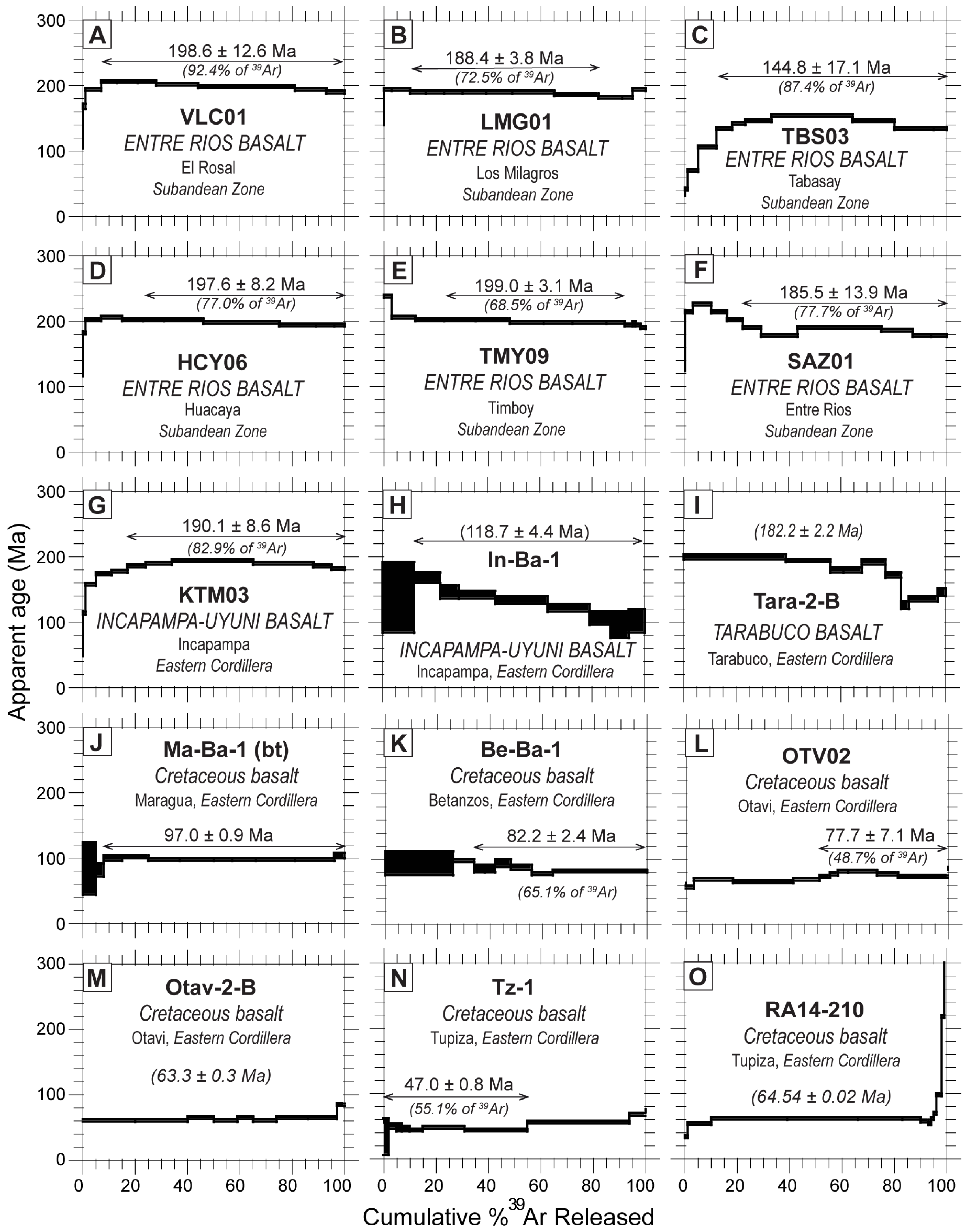
40Ar/39Ar geochronological results for 15 basalt horizons related to Mesozoic magmatism provide insights into (1) mafic igneous activity during varied sedimentary and deformational episodes, and (2) igneous emplacement ages and refined depositional age constraints for multiple clastic units (Figure 3 and Figure 4; Table 2). 40Ar/39Ar incremental step-heat analyses were carried out at the New Mexico Geochronology Research Laboratory on 14 groundmass concentrates and 1 biotite separate. Further separation and analytical techniques and argon isotope data are presented in the Supplementary Materials (Tables S1 and S2). The samples have complex age spectra; we estimate their age by combining the increments defining the flattest part of each spectra and refer to this as a plateau age. The plateau age is calculated by summing the isotopes for the indicated steps to obtain the date, with the error defined by the standard deviation of the plateau age steps. This calculation is referred to as isotope recombination (IsoComb) and is essentially a total gas age for selected steps rather than the entire age spectrum. In some cases an inverse isochron age is calculated (Figure 7; Table 2), which enables evaluation of the effect of excess argon contamination [97,98].

5.2. Jurassic Basalts

40Ar/39Ar results for six samples of the Entre Ríos basalt, collected from different sections at 19.5–21.2°S in the western Subandean Zone (Figure 3 and Figure 4; Table 2), provide Early Jurassic ages ranging from 199.0 ± 3.1 to 185.5 ± 13.9 Ma, with a single poorly constrained Late Jurassic age of 144.8 ± 17.1 Ma (Figure 7). The new 40Ar/39Ar age results are presented from north to south. In the El Rosal section (19.5°S), columnar jointed basalts were emplaced at 198.6 ± 12.6 Ma (Figure 7A). In the Los Milagros section (20.75°S), aphanitic basalts with minor plagioclase and chlorite crystals provide an age of 188.4 ± 3.8 Ma (Figure 7B). At Tabasay (~21°S), fine-grained basalts with alternating vesicular and massive flows record an anomalous age of 144.8 ± 17.1 Ma (Figure 7C). In contrast, basalts from the Huacaya section (21°S) yield an age of 197.6 ± 8.2 Ma (Figure 7D). Farther south in the Timboy section (21.2°S), amygdaloidal basalts yield an age of 199.0 ± 3.1 Ma (Figure 7E). At the Entre Ríos section, similar basalts with plagioclase and chlorite crystals within an aphanitic groundmass provide an isochron age of 185.5 ± 13.9 Ma (Figure 7F).
Separately, in the Eastern Cordillera, three basalt samples from the Tarabuco syncline (19°S) and Incapampa syncline (19.5°S) record contemporaneous Early Jurassic magmatism (Table 2). A dark green, fine-grained sample from the upper Incapampa-Uyuni basalt yields a plateau age of 190.1 ± 8.6 Ma (Figure 7G). The >100 m thick mafic unit includes well-developed columnar jointing, pahoehoe texture, and diagnostic granules to pebbles at the base of the overlying red nonmarine succession (basal Tacurú Group) consistent with subaerial emplacement, although associated sills have been reported [8,68,77]. Highly altered amygdaloidal intervals within the Incapampa-Uyuni basalt may explain the excess argon observed in the isochron analysis for the sample, which yields a preferred age of 118.7 ± 4.4 Ma that is younger than the total gas age of 129.3 ± 8.7 Ma (Figure 7H). In the Tarabuco syncline, a comparable basalt yields a total gas age of 182.2 ± 2.2 Ma (Figure 7I).
From these 40Ar/39Ar results, we interpret emplacement of multiple Lower Jurassic basalt flows and associated sills that were commonly altered by post-emplacement heating and fluid interactions across the western Subandean Zone and easternmost Eastern Cordillera. These tholeiitic basalts record the broadly 200–180 Ma addition of magmatic material from a juvenile mantle reservoir, potentially facilitated by new or inherited crustal heterogeneities during extension [22,39,63]. A possible network of ultramafic dikes in the central to western Eastern Cordillera [69] and coeval sills of the eastern Subandean Zone are consistent with extensional conditions along the Early Jurassic Andean margin [31,43], with the potential additional influence of plume-related magmatism affiliated with the Central Atlantic Magmatic Province [77].

5.3. Cretaceous Basalts

40Ar/39Ar results for basalts within the Puca Group of the Eastern Cordillera indicate several phases of Cretaceous-Paleocene magmatism, from broadly 100 to 60 Ma (Table 2). Age results for six samples are presented from north to south, from oldest to youngest. In the Maragua syncline (19°S), near Sucre, a sample of the Maragua basalt yields a plateau age of 97.0 ± 0.9 Ma (Figure 7J). The presumed time-equivalent Betanzos basalt flow [11,99] from the Betanzos syncline (19.5°S) is shown to have a younger emplacement age of 82.2 ± 2.4 Ma (Figure 7K). Farther south in the Otavi or San Lucas syncline (20°S), duplicate basalt samples show disturbed plateau ages, and total gas ages of 77.7 ± 7.1 Ma and 63.3 ± 0.3 Ma (Figure 7L,M).
These 40Ar/39Ar results are integrated with previous data suggesting several discrete mid-Cretaceous to Paleocene episodes of mafic magmatism ([9,88] and references therein). However, similar but indeterminate plateau ages along with disturbed total gas ages of 47.0 and 64.5 Ma (Figure 7N,O; Table 2) for two altered basalts within the Upper Cretaceous interval near Tupiza suggest a complicated thermal resetting after inferred Mesozoic emplacement. The large uncertainties (MSWD > 3) associated with these ages and their discordance with Cretaceous stratigraphic age constraints [46] suggest they represent post-emplacement alteration or a younger thermal episode [100].

6. U-Pb Geochronology

6.1. Methods

U-Pb geochronological results for 18 medium-grained sandstones and five volcanic rocks (tuffs) refine the chronostratigraphic and provenance framework for the mostly nonmarine, nonfossiliferous Permian to Cretaceous deposits of southern Bolivia (Figure 8, Figure 9, Figure 10 and Figure 11). Most sandstone samples were collected from the western flanks of the Incapampa and Entre Ríos synclines (Figure 2, Figure 3 and Figure 4). Three previously reported U-Pb analyses [96] are also included.
Zircon U-Pb age distributions were obtained from laser ablation inductively coupled mass spectrometry (LA-ICP-MS), following techniques previously described for the laboratory [101,102]. Zircon grains were separated following standard water table, heavy liquid, and magnetic separation procedures. For each sandstone sample, a total of roughly 120 randomly selected grains devoid of inclusions and cracks were analyzed. For volcanic rocks, up to 30 euhedral, inclusion-free, and non-fractured zircons were analyzed. U-Pb ages with >30% discordance and >5% reverse discordance were excluded from further consideration. The ages utilized reflect 206Pb/238U ages for grains younger than 950 Ma and 206Pb/207Pb ages for grains older than 950 Ma. Crystallization ages were calculated from the dominant peak mode of the kernel density estimation (KDE) plots (Figure 8A–E) using at least three grains overlapping at 2σ uncertainty, with mean square weighted deviation (MSWD) values near 1 [103]. Maximum depositional ages for individual detrital samples (Figure 8F–H) were calculated through consideration of individual zircon ages and dominant age components for the youngest grain clusters [104,105]. The U-Pb geochronological results are summarized (Table S3) and plotted as probability distribution functions with corresponding age histograms (Figure 9, Figure 10 and Figure 11).

6.2. Chronostratigraphic Constraints

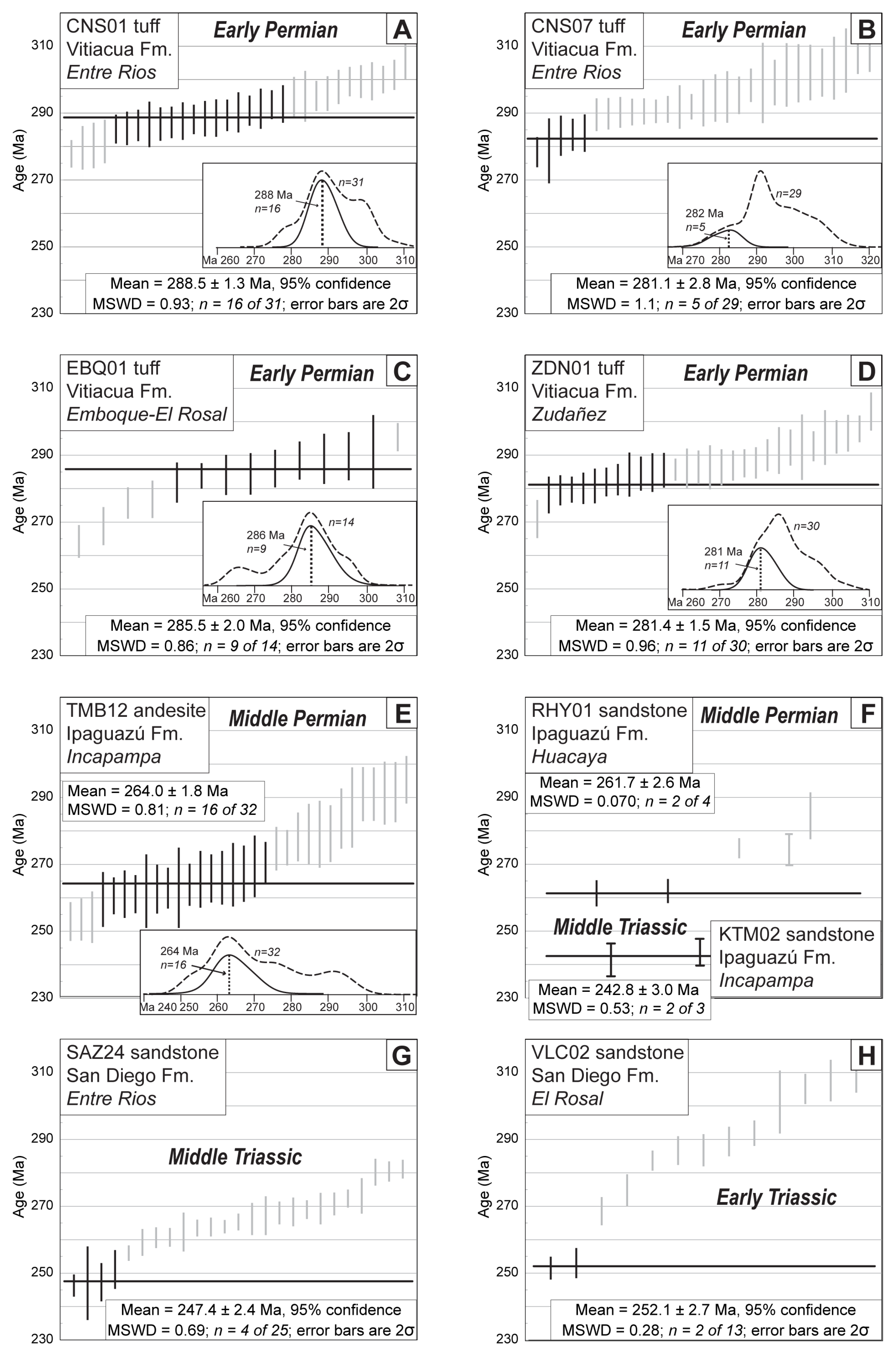
U-Pb results for four volcanic tuffs, a porphyritic andesite, and maximum depositional ages for seven sandstones (Figure 8; Table S3) refine the Permian–Cretaceous chronostratigraphic framework. In lower stratigraphic levels, interbedded tuffs from the Vitiacua Formation (near the Entre Ríos, El Rosal, and Zudañez sections) provide weighted mean ages of 288.5 Ma, 281.1 Ma, 285.5 Ma, and 281.4 Ma (n = 16, 5, 9 and 11) (Figure 8A–D). These maximum depositional ages are consistent with palynomorph assemblages [61] in supporting an Early Permian (Cisuralian) stratigraphic age for the Vitiacua Formation.
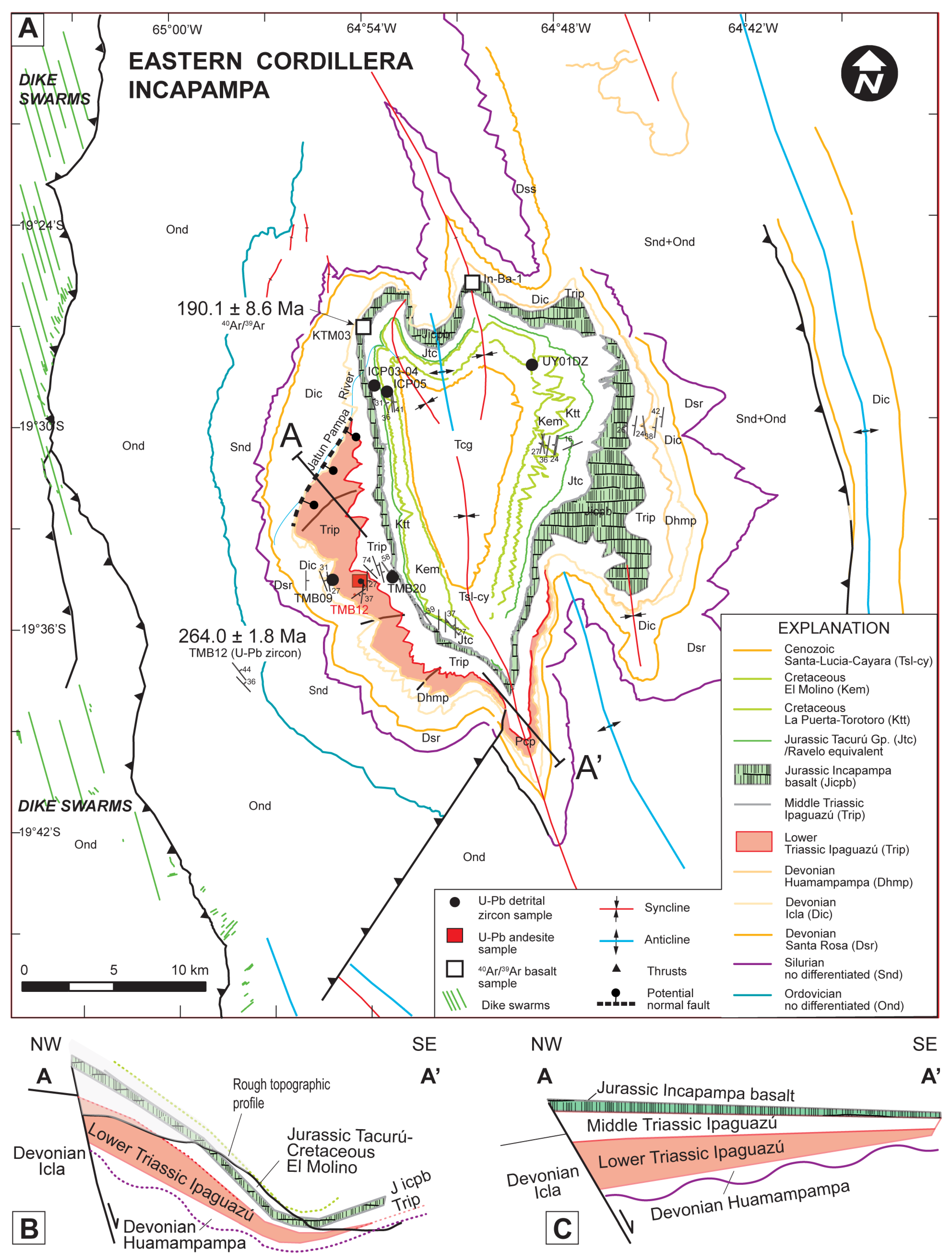
A new igneous emplacement age for a newly identified ~300 m thick porphyritic andesitic flow associated with coarse breccias along the western margin of the Incapampa syncline (Figure 12) yields a minimum U-Pb age of 264.0 Ma (n = 16; Figure 8E). This Middle Permian (Guadalupian) age documents volcanic activity during coarse clastic deposition in southern Bolivia, consistent with similar activity in northern Bolivia and southern Peru [38,106].
Four samples from the Triassic Ipaguazú and San Diego Formations exhibit youngest zircon components of Middle Permian to Middle Triassic age. Two Ipaguazú samples (Figure 8F) yield weighted mean ages of 242.8 ± 3.0 (n = 3) and 261.7 ± 2.6 Ma (n = 2). The youngest age components recorded in two San Diego samples are 247.4 ± 2.4 Ma (n = 4) and 252.1 ± 2.7 Ma (n = 2) (Figure 8G,H). These results confirm Early to Middle Triassic deposition, with the possibility of Late Permian deposition at lowermost levels. An upsection decrease in youngest age components—from Late Permian–Middle Triassic (Ipaguazú) to Early–Middle Triassic (San Diego)—is compatible with detrital contributions from (1) Middle Permian volcanic rocks in the Eastern Cordillera (this study) and (2) Permian–Early Triassic igneous rocks in northern Chile and Argentina [34,36]. Overall, the results indicate that principally Triassic-age sedimentation in Bolivia was contemporaneous with comparable nonmarine deposition of the Mitu Group in southern Peru [8,37,38,40].
Within the Jurassic–lowermost Cretaceous interval, U-Pb ages from three sandstones of the Tacurú Group (Tapecua, Castellón and Ichoa Formations) document young detrital zircon age components that decrease in age upsection: 192.1 ± 5.5, 176.0 ± 3.9, and 144.5 ± 3.1 Ma, respectively. Despite the limited number of zircons, these Jurassic to earliest Cretaceous age components provide the best estimates for the long-debated age assignments for fluvio-eolian successions of the Subandean Zone [22,64,107].

6.3. Potential Sediment Sources

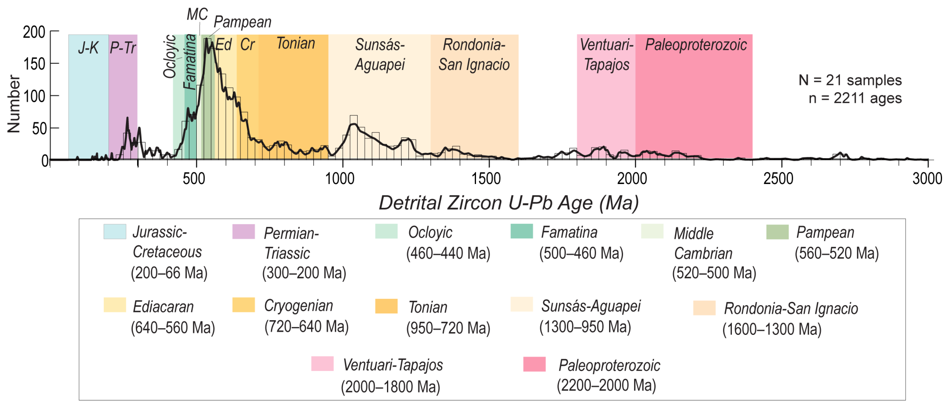
Possible sediment sources during Permian–Cretaceous deposition include (from oldest to youngest): (1) Precambrian crystalline basement exposed to the east in the Amazonian craton; (2) extensive Ordovician-Carboniferous sedimentary rocks deformed during late Paleozoic orogenesis; (3) widespread Permian–Triassic igneous provinces (Choiyoi Group of Argentina-Chile, Mitu Group of Peru, and probable Bolivian counterparts); (4) a belt of Jurassic and Cretaceous magmatic arc rocks in northern Argentina-Chile; and (5) recycled Permian–Cretaceous basin fill from proximal sources. To help link analyzed samples to potential source regions, we first summarize the detrital zircon age distributions from Neoproterozoic to Carboniferous rocks and younger source units (Figure 9).
(1) The Amazonian craton exposed in eastern Bolivia and western Brazil represents amalgamated Paleoproterozoic and Mesoproterozoic basement rocks of the Ventuari-Tapajos (2.0–1.8 Ga), Rio Negro-Juruena (1.8–1.5 Ga), Rondonia-San Ignacio (1.6–1.3 Ga), and Sunsás-Aguapei (1.3–0.95 Ga) provinces (Figure 9; [108,109,110] and references therein). These tectonic provinces consist of igneous, metamorphic, and sedimentary rocks affiliated with Precambrian supercontinent assembly and breakup, including the ~1 Ga Rodinia supercontinent [111,112].
(2) Paleozoic sedimentary rocks include a >10 km thick panel of marine Ordovician and Silurian–Devonian strata across the Eastern Cordillera, with Carboniferous strata currently limited to the Subandean Zone and Chaco Plain (Figure 3). While Carboniferous rocks display major Ediacaran (640–560 Ma) and Middle Cambrian (520–500 Ma) signatures [24], Silurian–Devonian units record principally Famatina-Ocloyic (500–420 Ma), Middle Cambrian (520–500 Ma) and Paleoproterozoic (2.2–2.0 Ga) detrital zircon signatures. The distribution of Paleozoic units and subcrop relationships for Mesozoic units suggest that Carboniferous rocks were eroded in both eastern (e.g., Izozog high) and western (Eastern Cordillera) source regions, with older Ordovician and Silurian–Devonian rocks limited to western and southern sources in the present Eastern Cordillera of Bolivia and Argentina.
(3) Permian–Triassic igneous rocks crop out extensively to the north, west, and south in the Eastern Cordillera of Peru to northern Bolivia and the broader Andean segments of Chile and Argentina [8,34,36,37,40,113,114]. Rocks to the south (Choiyoi Group) are concentrated in a Permian–Early Triassic (300–240 Ma) age range, whereas those in the north (Mitu Group) are principally of Early–Middle Triassic (240–220 Ma) age [7,38,115]. Although volumetrically less significant, new results for the Incapampa syncline (Figure 8E) demonstrate the potential of proximal sources of Late Permian igneous rocks in the Eastern Cordillera of southern Bolivia.
(4) A continuous Jurassic–Cretaceous magmatic arc constituted a long-lived potential source of igneous material, where intermediate and bimodal magmatism generated 200–100 Ma and <80 Ma age groups [31,43]. The presence of these age signatures can be definitively linked to source rocks west of the study area.
(5) Permian–Cretaceous sedimentary rocks may have been partially recycled during late Paleozoic–Mesozoic basin development [8,22]. Erosional recycling (or cannibalization) of contemporaneous or recently deposited clastic material in northern Bolivia and southern Peru is consistent with derivation from localized basin-bounding uplifts [38].

6.4. Detrital Zircon Provenance Results

Detrital zircon U-Pb geochronological results for 19 sandstone samples (Figure 10 and Figure 11) define key zircon age components and provenance shifts in the Subandean Zone (Entre Ríos syncline) and Eastern Cordillera (Incapampa syncline) during four time intervals: (1) Permian; (2) Triassic; (3) Jurassic; and (4) Cretaceous.

6.4.1. Permian Provenance

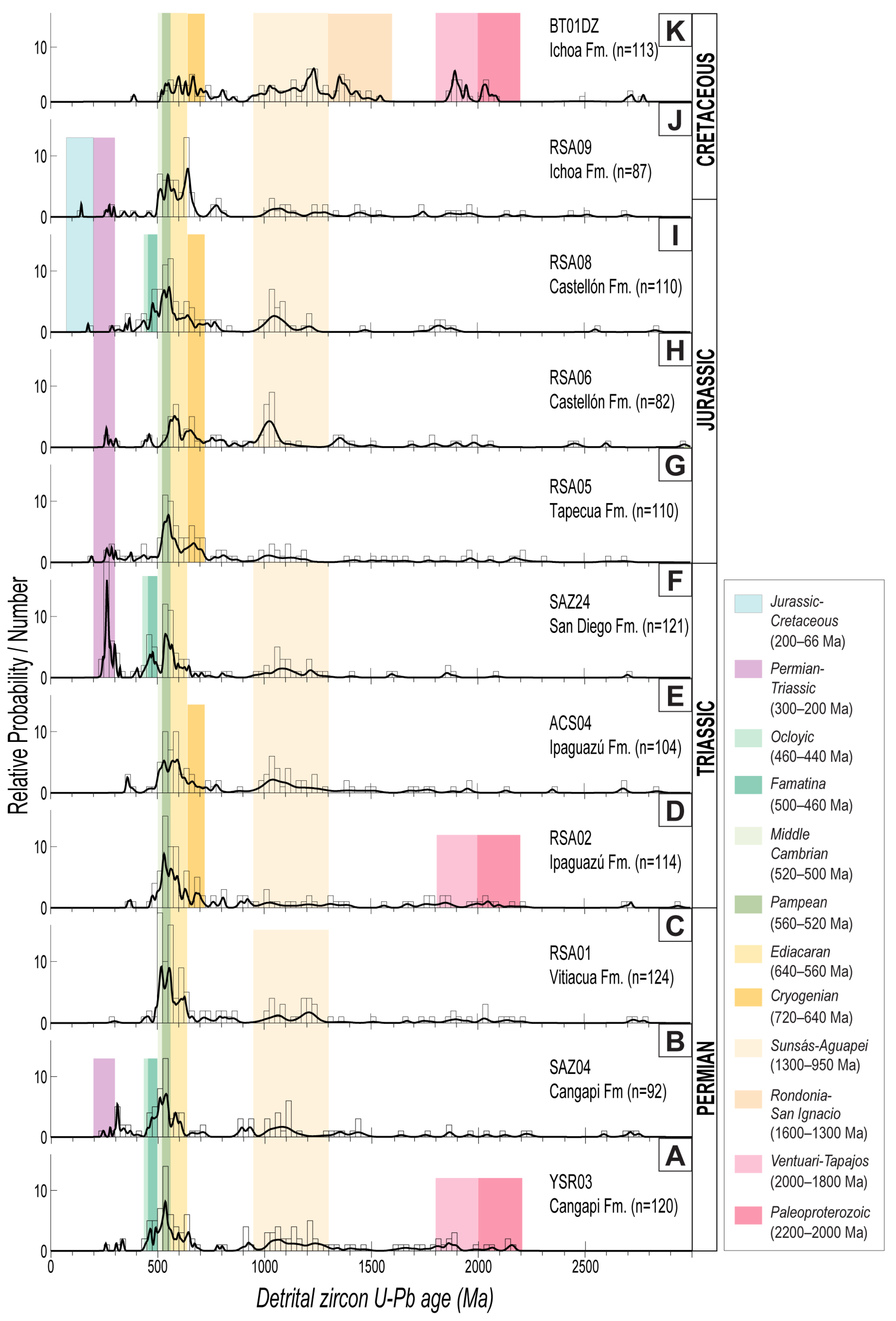
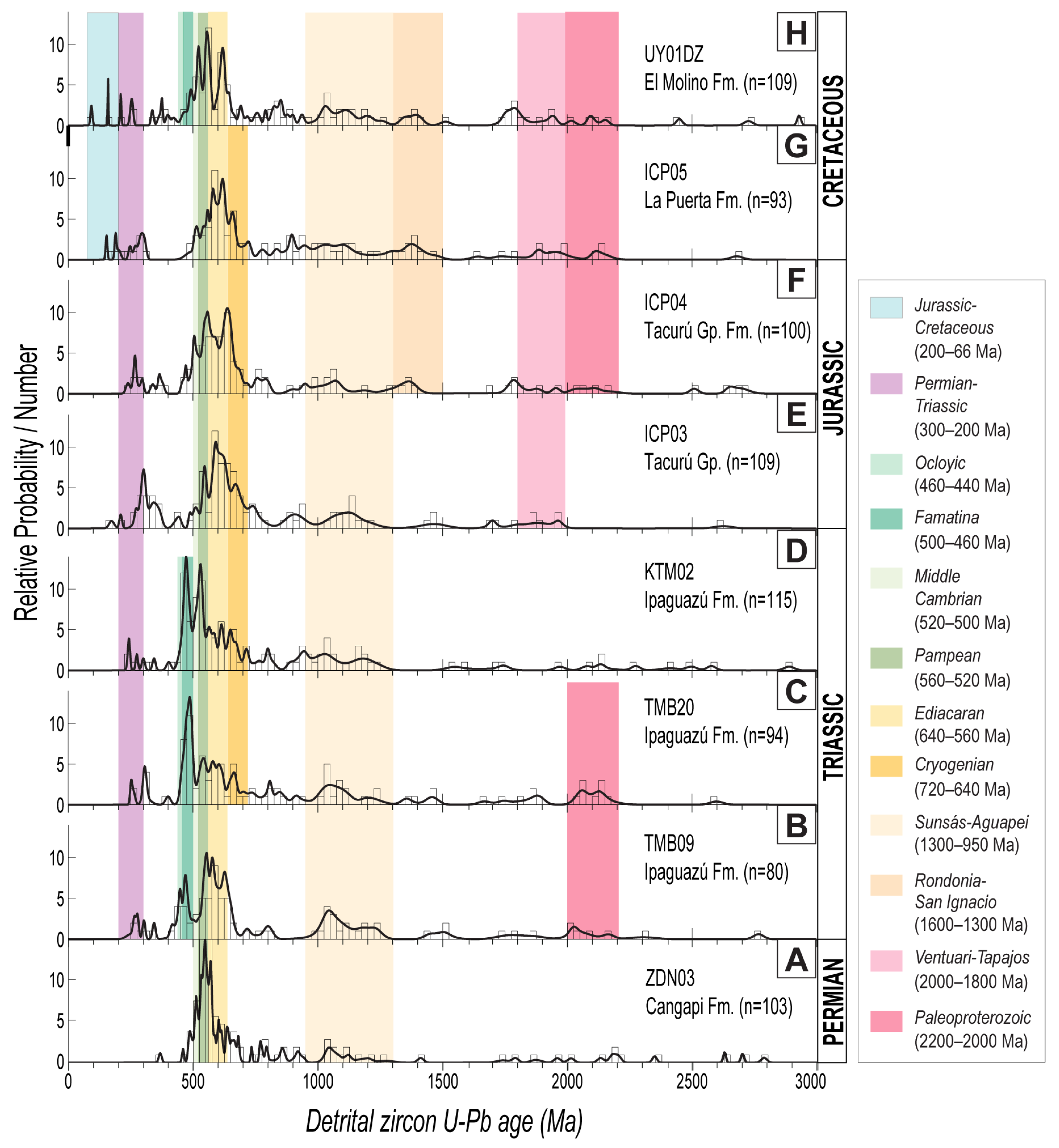
U-Pb age distributions for the Lower Permian Cangapi and Vitiacua Formations reveal a cosmopolitan zircon age assemblage, including predominantly Famatina-Ocloyic (500–420 Ma), Middle Cambrian (520–500 Ma), and Pampean (560–520 Ma) signatures, with a variable presence of older Precambrian (>950 Ma), Ediacaran (640–560 Ma), and Devonian to Permian (400–250 Ma) ages (Figure 10A–C and Figure 11A). The results show an upsection disappearance of Famatina-Ocloyic, Devonian to Permian, and Precambrian ages combined with an increase in Ediacaran and Cryogenian components. This trend may indicate a shift from (1) Devonian–Carboniferous western sources and distal eastern cratonic sources for the Cangapi Formation to (2) focused Carboniferous contributions from a western topographic high during Vitiacua marine ingression. This interpretation is consistent with derivation from remnant highlands from a late Paleozoic fold belt in the Eastern Cordillera and west-directed paleowinds from eastern cratonic regions [92,116].

6.4.2. Triassic Provenance

U-Pb results for the Triassic Ipaguazú and San Diego Formations in the Subandean Zone (Figure 10D–F) and Eastern Cordillera (Figure 11B–D) record a sharp change in provenance. In the Subandean Zone, fluvio-lacustrine Ipaguazú samples reveal the dominance of Pampean and Ediacaran ages (640–520 Ma), with minor proportions of Precambrian (>950 Ma), Cryogenian (720–640 Ma), and Devonian zircons (400–360 Ma). In contrast, the fluvio-eolian San Diego sandstones reflect pronounced Permo–Triassic ages (300–200 Ma) accompanied by Famatina-Ocloyic (500–420 Ma), Pampean (560–520 Ma), and reduced Ediacaran (640–560 Ma) and Precambrian (>950 Ma) components. The Ipaguazú results indicate significant Late Carboniferous contributions and recycling of Permian sediments with cratonic signatures. Upsection, the San Diego results show the distinct input of Permian–Triassic age grains along with derivation from Upper Carboniferous and Permian Vitiacua successions. These interpretations are in accordance with western sources of Permian–Triassic igneous rocks [36,114] and deep erosion of Permian Vitiacua rocks, as observed at El Rosal (Figure 4A).
Triassic deposits in the Eastern Cordillera (Figure 11B–D) include distinctive Famatina-Ocloyic (500–420 Ma) age peaks and a progressive upsection increase in Cryogenian, Ediacaran, Pampean, and Middle Cambrian (720–640, 640–560, 560–520, and 520–500 Ma) ages, along with sustained input of Permian–Triassic and anomalous Paleoproterozoic (2.2–2.0 Ga) grains. The paired Famatina-Ocloyic and Paleoproterozoic ages suggest exhumation of Silurian–Devonian rock within the late Paleozoic high occupying the Eastern Cordillera to the west. The systematic addition of Precambrian detritus of Cryogenian and Tonian age reflects clear input from eastern cratonic regions. The sustained presence of Triassic ages points to additional western source regions within the early Andean magmatic arc, consistent with lithofacies distributions and paleocurrent trends.

6.4.3. Jurassic Provenance

U-Pb age distributions for the Jurassic–lowermost Cretaceous deposits in the Subandean Zone (Figure 10G–K; Tapecua, Castellón, and Ichoa Formations) and Eastern Cordillera (Figure 11E,F; proposed time-correlative units) highlight contrasting source regions. In the Subandean Zone, results show a return of Pampean and Ediacaran (560–520 and 640–560 Ma) age signatures, upsection elimination of significant Permo–Triassic and Famatina-Ocloyic ages, introduction of syndepositional Jurassic ages, and a sustained presence of Proterozoic ages (Figure 10G–K). The readily identifiable shift from Carboniferous–Permian sources during Tapecua deposition (Figure 10G) to cosmopolitan sources with a major introduction of Precambrian (>950 Ma) ages during Ichoa deposition (Figure 10G–K) point to the transition from initial western sources of local basin-margin uplifts to regional west-directed fluvial and eolian systems from distal cratonic regions. The reduced magmatic arc age signature reflects a limited connection to the western magmatic arc at this time [31,43].
In Jurassic samples of the Eastern Cordillera (Figure 11E,F), a similar dominance of Ediacaran to Cambrian (640–520 Ma) ages, a large Cryogenian–Tonian component (950–640 Ma), and upsection expansion of Precambrian ages indicate westward sediment dispersal. Eastern source areas are consistent with paleocurrent data and include Subandean to Chaco Plain exposures of Carboniferous–Permian rocks and Precambrian basement farther east [117].

6.4.4. Cretaceous Provenance

U-Pb age distributions for two Cretaceous sandstones in the Eastern Cordillera (Figure 10G,H) show chiefly Ediacaran (640–560 Ma) ages during initial Puca Group deposition and broader Ediacaran to Pampean (640–520 Ma) signatures during later Puca Group deposition. For initial Puca Group deposition (La Puerta-Torotoro Formation), Ediacaran and subordinate Permo–Triassic (300–200 Ma) age groups along with the sustained Proterozoic ages are consistent with erosion of Carboniferous–Triassic rocks along a potential proximal basin margin in the east, possibly associated with mid-Cretaceous extensional structures. For the uppermost Puca Group (El Molino Formation), enhanced cratonic provenance is consistent with erosional recycling of the Lower Cretaceous Ichoa Formation in the Subandean Zone to Chaco Plain. West-directed paleocurrents along with eastward onlap onto older Mesozoic units suggest that initial localized depocenters during fluvial and alluvial fan deposition of the basal Puca Group transitioned into an expanded regional sag with distal fluvial and lacustrine deposition during upper Puca Group sedimentation [11,46,72].

7. Basin Architecture

To shed light on evolving basin architecture during Permian–Cretaceous sedimentation, we focus on two regions of southern Bolivia with structural and stratigraphic evidence for syndepositional deformation (Figure 12 and Figure 13). Cross-cutting relationships, stratigraphic trends, and sedimentologic criteria integrated with new geochronological results enable the delineation of several phases of local extension and post-extensional subsidence in separate segments of southern Bolivia.

7.1. Eastern Cordillera: Incapampa Extensional Basin Fill

In the easternmost Eastern Cordillera at ~19.5°S, new U-Pb ages (~264–191 Ma) from the western limb of the Incapampa syncline bracket a previously undocumented Mesozoic deposit that unconformably overlies folded Devonian rocks (Figure 12). A key relationship along a ~20 km-long transect is expressed by abrupt southeastward thinning (from >700 m to <100 m) of a local volcaniclastic package within the basal Ipaguazú Formation (Figure 12A). Although no clear fault is identified, facies distributions corresponding to cobble-boulder breccias document proximal accumulation along the thick NW segment of this stratigraphic wedge (Figure 12B). These fault-proximal facies and pronounced thickness variations suggest a basin-bounding extensional fault, likely parallel to the 030° trending Jatun Pampa river, which exposes Devonian Icla to Mesozoic units over a >12 km long swath. In this scenario, restoration (untilting) of basal Ipaguazú hanging-wall strata (~27–37°SSE dip) to their original horizontal orientation reveals an originally NW-dipping basin panel, toward the inferred SE-dipping normal fault (Figure 12C). This proposed half-graben geometry is in agreement with minor fault offsets of underlying Devonian rocks and is consistent with the structural compartmentalization of multiple half-graben basins observed in Mesozoic extensional settings of western South America [16,44,45,47,118].
Above the coarse-grained volcaniclastic wedge (basal Ipaguazú Formation), a ~250–300 m thick tabular package of uniform thickness (upper Ipaguazú Formation) blankets both limbs of the Incapampa syncline (Figure 12A,B). Although this younger package of alluvial fan and fluvial strata succeeds the basal volcaniclastic wedge on the western limb, equivalent lacustrine and eolian rocks unconformably overlie Devonian rocks on the eastern flank. These abrupt changes in facies and thickness further support a fault-proximal source region to the west. Independent U-Pb analyses highlight a western source of exhumed Devonian rocks (Figure 11B–D) while conglomerate clasts and fossil fragments from the Permian Copacabana and Vitiacua Formations indicate comparable erosion of these units [116]. The overlap of the localized half-graben stratigraphic wedge by the more-expansive Ipaguazú succession is consistent with a temporal transition from fault-induced synrift subsidence to post-extensional thermal subsidence of a regional sag basin (Figure 12C) [119,120,121].

7.2. Subandean Zone: Ipaguazú Extensional Basin Fill

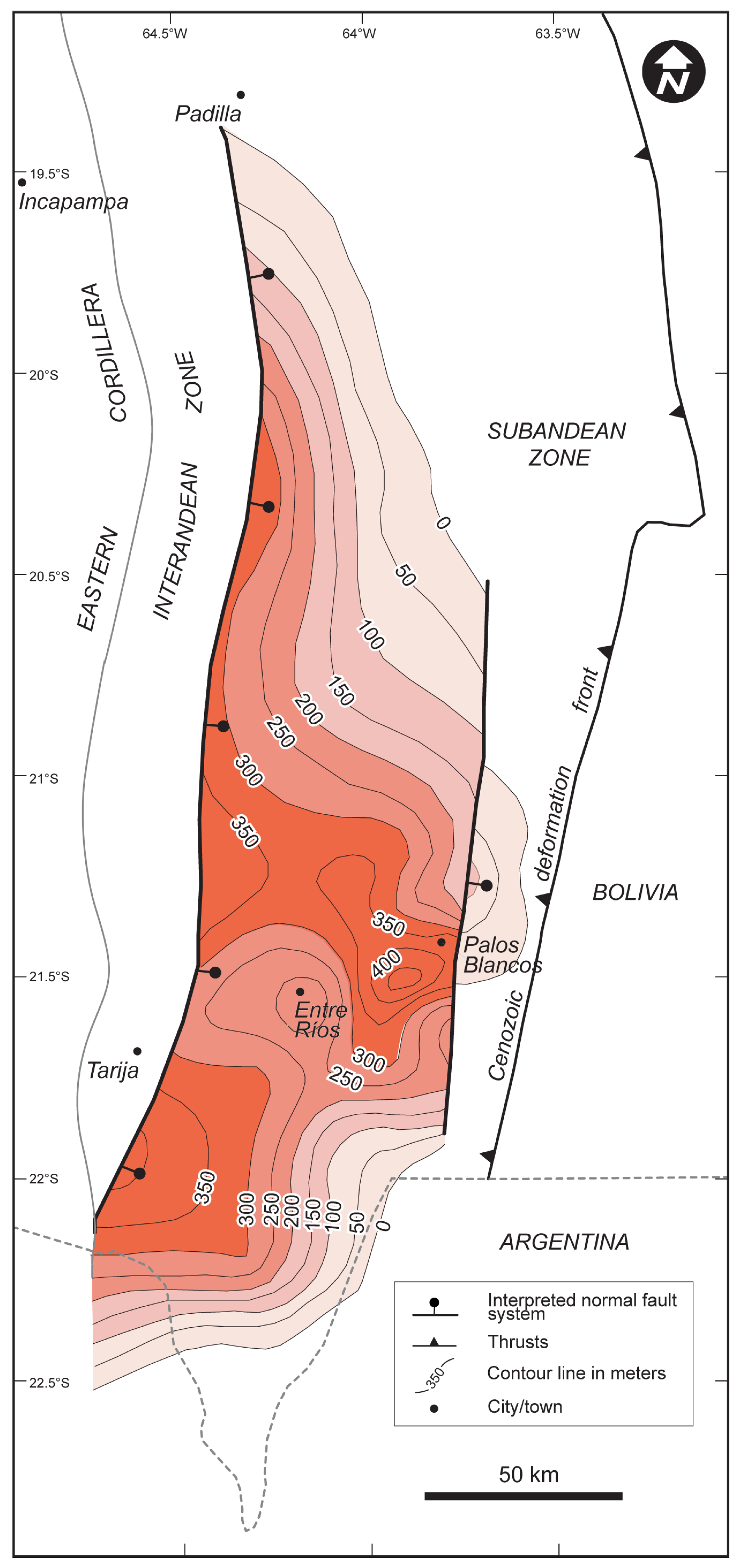
A separate Subandean accumulation of anomalously thick Triassic deposits at 19.5–22.5°S indicates that Mesozoic extension also affected inboard eastern segments of southern Bolivia. Integration of thickness trends from an isopach map of the Triassic Ipaguazú Formation (Figure 13) with sedimentologic and provenance data (including paleocurrent and U-Pb results; Figure 4 and Figure 10) offers insights on the structural and stratigraphic framework for these deposits. The isopach map depicts an asymmetric, westward-thickening depocenter with maximum thickness (~500 m) adjacent to a proposed north-striking normal fault in the westernmost Subandean Zone (Figure 13). Although minor thickness overrepresentations may relate to internal shortening [122] and local dissolution of evaporitic facies, the isopach map depicts thickness trends compatible with our measured sections and previous reports [76]. This basin depocenter has a ~100 km east-west width and persists for >200 km along strike, southward into Argentina where it was eroded by basin-margin uplifts on the flanks of the Cretaceous Salta Rift [21,123].
The spatial distribution and provenance constraints for the Ipaguazú and overlying San Diego Formation document key contrasts in Triassic accommodation and sediment routing. Importantly, the Ipaguazú thickness trends (Figure 13) are compatible with a half-graben basin along the western margin of the Subandean Zone. Progressive motion along an east-dipping normal fault system resulted in not only asymmetric hanging-wall subsidence and accommodation of a thick Ipaguazú depocenter, but also erosion of Carboniferous–Permian rocks in the uplifted western footwall (Figure 13). This phase of normal faulting and local deposition was succeeded by the regionally overlapping San Diego Formation, which sits unconformably on Permian Vitiacua or older formations in the El Rosal section of the westernmost Subandean Zone (Figure 4A). This pattern of Triassic basin reorganization matches the shift in U-Pb age distributions from an initial local western source of upper Paleozoic rocks (Ipaguazú; Figure 10D,E) to more-regional cosmopolitan sources that included the early Andean magmatic arc (San Diego; Figure 10F). Collectively, these relationships support a pattern of fault-induced subsidence with local provenance followed by protracted regional thermal subsidence with an assortment of sediment sources.

8. Discussion

Integration of field-based sedimentologic and stratigraphic results with new U-Pb and 40Ar/39Ar geochronological results enables an assessment of several key uncertainties regarding Permian–Cretaceous basin evolution in central Andean regions during progressive extensional breakup of western Gondwana. We address the chronostratigraphic framework and depositional ages for the largely nonmarine sedimentary record, and then discuss new constraints on source regions, sediment routing systems, and basin architecture to develop a generalized reconstruction of the temporal and spatial history of basin evolution and associated tectonic processes in southern Bolivia.

8.1. Chronostratigraphic Framework

U-Pb geochronologic results for volcanic and sedimentary rocks help refine the chronostratigraphic framework for the Permian–Cretaceous sedimentary record of southern Bolivia. Previously inferred late Paleozoic–early Mesozoic ages for the Vitiacua Formation [8,22] are here revised to a chiefly Early Permian age on the basis of U-Pb ages for four interbedded tuffs ranging from 288.5 ± 1.3 to 281.4 ± 1.5 Ma, in agreement with fossil pollen [61]. The Vitiacua Formation is capped by an erosional unconformity and the overlying Triassic Ipaguazú Formation, which contains Middle Permian to Early Triassic detrital zircons (261.7 ± 2.6 to 242.8 ± 3.0 Ma). The overlying San Diego Formation records a maximum depositional age of 252.1 ± 2.7 to 247.4 ± 2.4 Ma, coincident with early Andean arc magmatism in northern Chile and Argentina [36,114].
40Ar/39Ar ages for the Entre Ríos basalt spanning from 199.0 ± 3.1 to 185.5 ± 13.9 Ma confirm an Early Jurassic emplacement age broadly consistent with plume-related magmatism of the Central Atlantic Magmatic Province [77]. Upsection, the Tapecua, Castellón and Ichoa Formations contain young detrital zircon components that are consistently Jurassic to earliest Cretaceous in age (192–144 Ma; n = 3). Although there are few zircon grains, this broad age range provides useful geochronological constraints for these mostly nonfossiliferous, nonmarine deposits. A Cretaceous depositional age may be viable for eastern exposures of the Castellón Formation, according to described fauna [64,65]. The paucity of younger Jurassic–Cretaceous syndepositional zircons argues for limited input from the western magmatic arc.

8.2. Multiphase Extension in Southern Bolivia

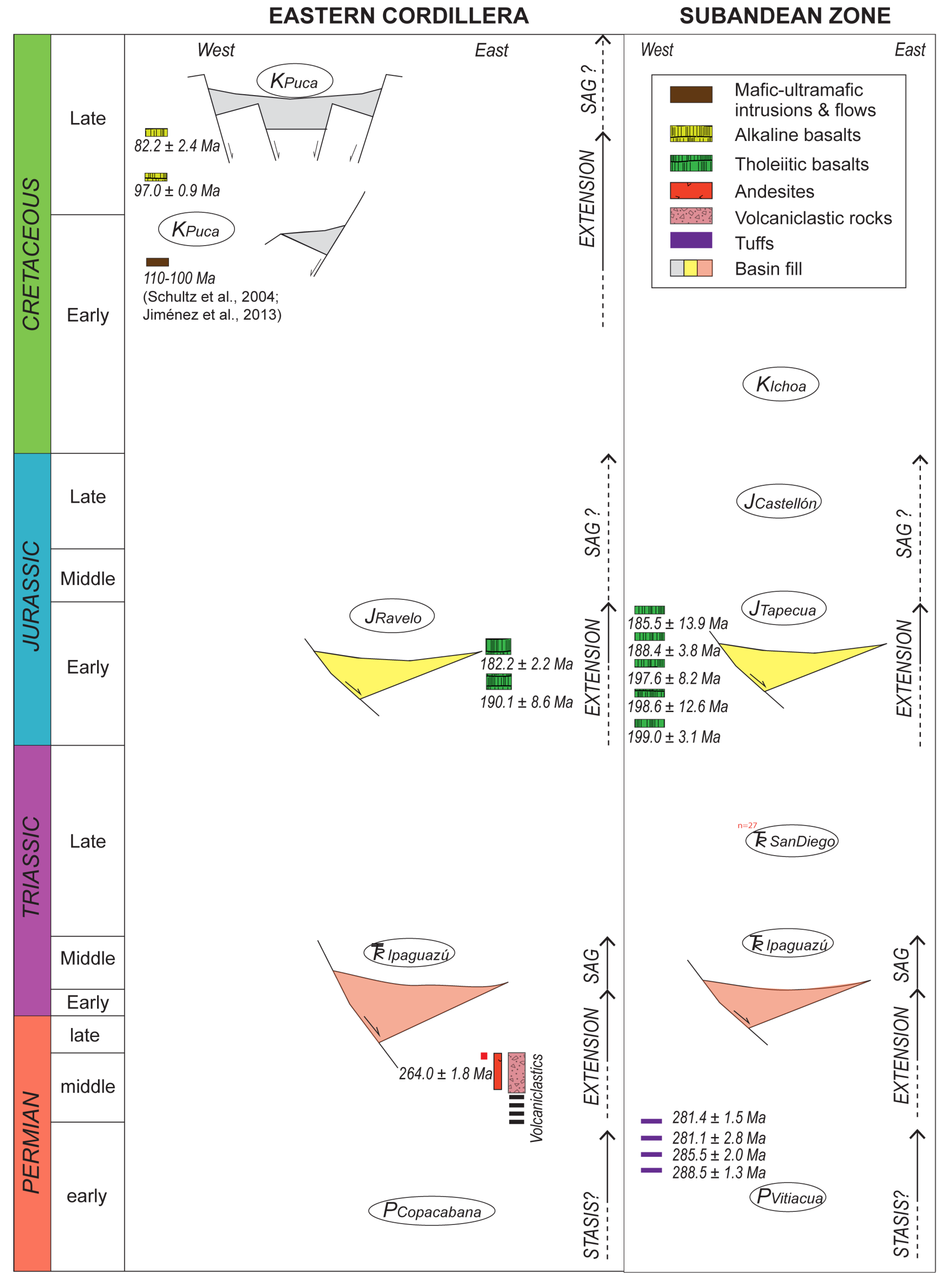
Multiphase Permian–Cretaceous extensional deformation represents a major transition from late Paleozoic growth of a convergent-margin orogen to Mesozoic supercontinent breakup and opening of the South Atlantic Ocean [14,25,44,124]. These processes influenced patterns of rock uplift and basin subsidence now preserved in the detrital record of western South America. In southern Bolivia, three extensional phases are recognized from Late Permian to Cretaceous time (Figure 14).
(1) Late Permian–Early Triassic (ca. 264–247 Ma) development of at least two narrow basins was controlled by SE-dipping normal faults in the Eastern Cordillera (Figure 12) and an E-dipping master fault along the western Subandean Zone (Figure 13). Both basins are defined as fault-bounded asymmetric depocenters (Ipaguazú Formation) with half graben geometries (Figure 12C). Protracted synextensional sedimentation is documented by the >700 m thick wedge of fault-proximal breccias and volcanic deposits in the Eastern Cordillera, compared to the <500 m thick clastic record in the Subandean Zone. In both cases (Figure 14), the hanging-wall stratigraphic wedges are succeeded by regionally expansive units suggestive of a transition from fault-induced subsidence to post-extensional thermal subsidence in regional sag basins.
(2) A separate Early Jurassic (ca. 200–180 Ma) phase of half-graben basin development was accompanied by widespread tholeiitic volcanism (Figure 14). In the Subandean Zone, older zones of Permo–Triassic accommodation expanded to the north and east, from 22°S to 19°S. This extension was accompanied by clastic deposition (Tapecua Formation) and widespread Early Jurassic emplacement of a >100 m thick basalt in the Eastern Cordillera (190 Ma Incapampa-Uyuni basalt) and <50 m basalts in the Subandean Zone (200–180 Ma Entre Ríos basalt). Stratigraphic overlap assemblages (Castellón and Ichoa Formations) across these subbasins and their flanking shoulders display multimodal provenance signatures, consistent with eastern cratonic input during thermal subsidence of Middle Jurassic–earliest Cretaceous age.
(3) Mid-Cretaceous synextensional development of half graben basins that evolved into large graben systems (lower Puca Group) occurred during several extensional episodes in the Eastern Cordillera and Altiplano (Figure 14). Mid-Cretaceous (ca. 110–100 Ma) extension was recorded by a W-dipping normal fault and associated basin-flank uplifts with alkaline mafic and ultramafic igneous activity in central Bolivia [125,126]. Although this main phase of extension overlapped with mid-Cretaceous opening of the South Atlantic, two early Late Cretaceous (ca. 95–90 Ma and ca. 85–80 Ma) episodes of mafic magmatism attest to further extension, likely accommodated by regionally distributed E- and W-dipping normal faults [10,13,46]. Final post-extensional thermal subsidence was recorded by regionally extensive Upper Cretaceous–Paleocene deposits (upper Puca Group) of Bolivia. Similar patterns of extension, magmatism, and thermal sag deposition are well documented in the correlative Salta Rift of northern Argentina [9,88,89,90].

8.3. Drivers of Multiphase Extension

Evidence of Permian–Cretaceous extension in Bolivia (Figure 14) improves tectonic reconstructions that bridge the gap between well-documented latest Paleozoic to Mesozoic extension in other central Andean regions, including southern Peru, northern Argentina, and Chile. However, the drivers of these multiphase extension processes remain unclear. For Early Triassic extension (Ipaguazú Formation), the basin geometries, facies distributions, and magmatic records of the Eastern Cordillera are broadly consistent with extensional collapse of a late Paleozoic orogenic belt [13]. This process could represent the culmination of contractional orogenesis associated with flat-slab subduction followed by collapse during resteepening of the slab [3]. Further geochemical analyses would clarify whether synextensional Triassic magmatism in Bolivia was more similar to subduction-related silicic magmatism in Argentina-Chile Choiyoi Group; [34,35] or backarc bimodal magmatism in Peru Mitu Group; [7,8,39,127].
The spatio-temporal distribution of Early Jurassic extensional basins (Tapecua Formation) and associated magmatism (Entre Ríos and related basalts) likely represents lithospheric stretching driven by extensional to transtensional deformation along an obliquely converging margin (Figure 14) [18,43,128]. This deformation may be related to a mantle plume attributed to the southernmost segment of the Central Atlantic Magmatic Province CAMP [77]. Given the limited (<400 m) thickness of Lower Jurassic clastic deposits, we infer lower magnitude extension in an intraplate setting of southern Bolivia relative to more regional distributed extensional basins in proximal (western) backarc positions (e.g., Arequipa and Atacama basins [8,13,43]).
Mid-Cretaceous extension and Late Cretaceous post-extensional thermal subsidence in southern Bolivia (Figure 14) coincided with crustal extension and alkaline magmatism in the Salta Rift of northern Argentina. This igneous activity occurred far east of the Cretaceous magmatic arc, consistent with basin growth and associated magmatism in an intraplate setting linked to extensional or transtensional episodes in the Eastern Cordillera and Altiplano [9,10,11,31,129]. In this manner, mid- to Late Cretaceous extension and magmatism can be linked to final extensional breakup of western Gondwana during opening of the South Atlantic Ocean [1,5,6,44,45].

9. Conclusions

  • Zircon U-Pb geochronological results for sandstones and volcanic rocks are combined with 40Ar/39Ar ages of basalts to revise the chronostratigraphic framework of Permian–Cretaceous strata of southern Bolivia. Interbedded tuffs from the Vitiacua Formation constrain marine deposition to the Early Permian (ca. 289–281 Ma). A previously undocumented andesite in the Eastern Cordillera along with detrital zircon U-Pb ages bracket extension-related volcanism to the Middle Permian (264.0 ± 1.8 Ma). U-Pb ages for young zircons of the fluvial Ipaguazú Formation (ca. 262 to 243 Ma) and fluvio-eolian San Diego Formation (ca. 252–247 Ma) are consistent with Triassic maximum depositional ages. The Tapecua, Castellón, and Ichoa Formations of the Tacurú Group are attributed to Jurassic-earliest Cretaceous accumulation in eolian and fluvial systems. Multiple Lower Jurassic basalt flows of the Entre Ríos Formation yield emplacement ages spanning from ca. 200 to 180 Ma, with the Incapampa-Uyuni and Tarabuco basalts focused at 190.1 ± 8.6 and 182.2 ± 2.2 Ma. In contrast, mid- to Late Cretaceous mafic magmatism in the Eastern Cordillera (ca. 95–90 Ma and ca. 85–80 Ma) coincided with extensional and post-extensional fluvio-lacustrine deposition.
  • Detrital zircon U-Pb results, paleocurrents, and spatial variations in Permian–Cretaceous depositional systems document a shift in sediment provenance from local western sources during extension followed by cosmopolitan sources during post-extensional accumulation in thermal sag settings. Following Permian eolian, fluvial, and marine sedimentation (Cangapi and Vitiacua Formations), discrete phases of synextensional sedimentation—including (1) Early Triassic fluvial, alluvial fan, and lacustrine deposition (Ipaguazú Formation), (2) Early Jurassic fluvio-eolian deposition (Tapecua Formation), and (3) mid-Cretaceous alluvial fan and fluvial deposition (lower Puca Group)—involved sediment derivation from older orogenic sources (Late Carboniferous and Devonian sedimentary rocks). In contrast, separate post-extensional deposits of principally fluvial and eolian origin—including the (1) Middle Triassic San Diego Formation, (2) Jurassic–lowermost Cretaceous Castellón-Ichoa Formations, and (3) Upper Cretaceous upper Puca Group—recorded diverse provenance signatures from eastern cratonic sources and western sources of post-orogenic (Silurian to Carboniferous sedimentary rocks) and Mesozoic magmatic arc material.
  • The basin architecture established during Early Triassic extension was defined by thickness variations, stratigraphic onlap and overlap relationships, lithofacies distributions, and provenance constraints. Half-graben basin geometries were associated with asymmetric depocenters (Ipaguazú Formation) linked to syndepositional SE- and E-dipping normal faults. The hanging-wall stratigraphic wedges were overlapped by post-extensional assemblages of Middle–Late Triassic age (San Diego Formation). Thick synextensional clastic and interbedded volcanic deposits point to extension and volcanism in the Eastern Cordillera and Subandean Zone, consistent with broader extensional patterns in the central Andes, including the Mitu Group of Peru.
  • Three separate Mesozoic extensional phases are recognized on the basis of stratigraphic relationships, igneous activity, paleoflow patterns, and U-Pb results. (1) Early Triassic growth of isolated half grabens and associated magmatism (limited to the Eastern Cordillera) was succeeded by a Middle–Late Triassic thermal sag phase. (2) Early Jurassic reactivation and northward expansion of basin-bounding normal faults was associated with widespread volcanism (Entre Ríos and related basalts). Subsequent Middle to Late Jurassic fluvial and eolian accumulation defined the ensuing thermal sag phase. (3) Mid-Cretaceous magmatism (95–90 and 85–80 Ma volcanic pulses) and possible limited extension generated renewed subsidence succeeded by Late Cretaceous–early Paleocene thermal subsidence.
  • Pre-Andean tectonic regimes varied from late Paleozoic shortening to alternating phases of Mesozoic extension and post-extensional thermal subsidence during incremental breakup of western Gondwana. However, the driving mechanisms of multiphase extension remain unclear. Extensional collapse of a precursor orogenic belt may account for compartmentalized Triassic basins and widespread Permian–Triassic magmatism in central Andean regions spanning Peru, Bolivia, Argentina, and northern Chile. In contrast, trench rollback along with mantle plume processes associated with the Central Atlantic Magmatic Province may have promoted localized extension during Early Jurassic basin formation. Finally, intracontinental extension in Bolivia and the associated Salta Rift of northern Argentina is considered the product of final breakup of western Gondwana during mid-Cretaceous extensional opening of the South Atlantic Ocean.

Supplementary Materials

The following supporting information can be downloaded at: https://www.mdpi.com/article/10.3390/stratsediment1010003/s1, Table S1: Summary of analytical techniques employed for sample preparation and 40Ar/39Ar dating; Table S2: Argon isotopic data for bulk samples step-heated in the resistance furnace for basalts from southern Bolivia; Table S3: Laser ablation high-resolution inductively coupled plasma mass spectrometry (LA-HR-ICP-MS) analyses for U-Pb geochronology of 5 volcanic rocks and 18 sandstone samples from southern Bolivia.

Author Contributions

Conceptualization, A.Z.C. and B.K.H.; Methodology, A.Z.C.; Software, A.Z.C.; Validation, B.K.H., R.B.A., R.G. and D.F.S.; Formal analysis, A.Z.C., R.B.A., B.K.H., O.Q., M.T.H. and D.F.S.; Investigation, A.Z.C., O.Q., C.A., R.G. and M.T.H.; Data curation, A.Z.C.; Writing—original draft preparation, A.Z.C.; Writing—review and editing, A.Z.C. and B.K.H.; Visualization, A.Z.C. and C.A.; Funding acquisition, B.K.H. and A.Z.C. All authors have read and agreed to the published version of the manuscript.

Funding

This research was funded by U.S. National Science Foundation grants (EAR-1250512 and EAR-1338694) awarded to B.K. Horton, and student research support from the American Association of Petroleum Geologists, Geological Society of America, SEPM (Society for Sedimentary Geology), and the Jackson School of Geosciences at the University of Texas at Austin awarded to A.Z. Calle. The Bureau of Economic Geology provided financial support for data curation and manuscript preparation to A.Z. Calle.

Data Availability Statement

The original contributions presented in this study are included in the article/Supplementary Materials. Further inquiries can be directed to the corresponding author.

Acknowledgments

We thank R. Limachi, O. Arispe, E. Requena, G. Villacorta, V. Ramirez, and D. Starck for critical insights into the geology of southern Bolivia, O. Zalles for paleontological assessments, and M. di Pasquo and G. Grader for Permian stratigraphic information. G. Uzeda, A. Buchizo, P. Muñoz, and J. Quispe provided field and logistical support. We thank L. Stockli, E. Pujols, M. Prior, and D. Barber for their support at the UTChron Laboratory, and A. Reisdorf, Z. Xue, M. Behnke, and A. Eljuri for assistance with mineral separation and sample preparation. We also appreciate valuable discussions with N. Perez, V. Oliveros, R. Mohammed, M. Bush, T. Capaldi, L. Jackson, C. Mackaman-Lofland, and R. Iriarte. We thank four anonymous reviewers for their constructive comments, which improved the clarity of the manuscript.

Conflicts of Interest

The authors declare no conflicts of interest.

References

  1. Ramos, V.A. Evolución tectónica de la plataforma continental. In Geología y Recursos Naturales de la Plataforma Continental Argentina; Ramos, V.A., Turic, M.A., Eds.; XIII Congreso Geológico Argentino and III Congreso de Exploración de Hidrocarburos: Buenos Aires, Argentina, 1996; pp. 385–404. [Google Scholar]
  2. Franzese, J.R.; Spalletti, L.A. Late Triassic-early Jurassic continental extension in southwestern Gondwana. Tectonic segmentation and pre-break-up rifting. J. S. Am. Earth Sci. 2001, 14, 257–270. [Google Scholar] [CrossRef] [Scilit]
  3. Ramos, V.A.; Folguera, A. Andean flat-slab subduction through time. Geol. Soc. Lond. Spec. Publ. 2009, 327, 31–54. [Google Scholar] [CrossRef] [Scilit]
  4. Mpodozis, C.; Cornejo, P. Cenozoic tectonics and porphyry copper systems of the Chilean Andes. Soc. Econ. Geol. Spec. Publ. 2012, 16, 329–360. [Google Scholar]
  5. Lovecchio, J.P.; Rohais, S.; Joseph, P.; Bolatti, N.D.; Ramos, V.A. Mesozoic rifting evolution of SW Gondwana. a poly-phased, subduction-related, extensional history responsible for basin formation along the Argentinean Atlantic margin. Earth Sci. Rev. 2020, 203, 103138. [Google Scholar] [CrossRef] [Scilit]
  6. Lovecchio, J.P.; Abdelmalak, M.M.; Planke, S.; Silio, O.; Rohais, S.; Arismendi, S.; Rojas Vera, E.; Kulhanek, D.K.; Bolatti, N.; Ramos, V.A. Mesozoic rifting in SW Gondwana and break-up of the southern South Atlantic Ocean. Geol. Soc. Lond. Spec. Publ. 2024, 547, 75–107. [Google Scholar] [CrossRef] [Scilit]
  7. Spikings, R.; Reitsma, M.J.; Boekhout, F.; Mišković, A.; Ulianov, A.; Chiaradia, M.; Gerdes, A.; Schaltegger, U. Characterization of Triassic rifting in Peru and implications for the early disassembly of western Pangaea. Gondwana Res. 2016, 35, 124–143. [Google Scholar] [CrossRef] [Scilit]
  8. Sempere, T.; Carlier, G.; Soler, P.; Fornari, M.; Rosas, S.; Jacay, J.; Arispe, O.; Ne, D. Late Permian—Middle Jurassic lithospheric thinning in Peru and Bolivia, and its bearing on Andean-age tectonics. Tectonophysics 2002, 345, 153–181. [Google Scholar] [CrossRef] [Scilit]
  9. Viramonte, J.G.; Kay, S.M.; Becchio, R.; Escayola, M.; Novitski, I. Cretaceous rift related magmatism in central-western South America. J. S. Am. Earth Sci. 1999, 12, 109–121. [Google Scholar] [CrossRef] [Scilit]
  10. Welsink, H.J.; Franco, M.; Oviedo, G.C. Structural Inversion of a Cretaceous Rift Basin, Southern Altiplano, Bolivia. In Petroleum Basins of South America; Tankard, A., Suárez, R., Welsink, H.J., Eds.; American Association of Petroleum Geologists Memoir: Tulsa, OK, USA, 1995; Volume 62, pp. 481–500. [Google Scholar]
  11. Cherroni, C. El Sistema Cretácico en la parte Boliviana de la cuenca Cretácica Andina. Rev. Técnica Yacim. Pet. Fisc. Boliv. 1977, 6, 5–46. [Google Scholar]
  12. Kusiak, M.E. El Mesozoico del Sistema Subandino de Bolivia: Evolución Sedimentaria y Síntesis de la Cuenca. Ph.D. Dissertation, Universidad de Buenos Aires, Buenos Aires, Argentina, 2008. [Google Scholar]
  13. McGroder, M.F.; Lease, R.O.; Pearson, D.M. Along-strike variation in structural styles and hydrocarbon occurrences, Subandean fold-and-thrust belt and inner foreland, Colombia to Argentina. In Geodynamics of a Cordilleran Orogenic System: The Central Andes of Argentina and Northern Chile; DeCelles, P.G., Ducea, M.N., Carrapa, B., Kapp, P.A., Eds.; Memoir 212; Geological Society of America: Boulder, CO, USA, 2015; pp. 79–113. [Google Scholar] [CrossRef] [Scilit]
  14. Ramos, V.A. The tectonic regime along the Andes: Present-day and Mesozoic regimes. Geol. J. 2010, 45, 2–25. [Google Scholar] [CrossRef] [Scilit]
  15. Horton, B.K.; Fuentes, F. Sedimentary record of plate coupling and decoupling during growth of the Andes. Geology 2016, 44, 647–650. [Google Scholar] [CrossRef] [Scilit]
  16. Mpodozis, C.; Ramos, V.A. The Andes of Chile and Argentina. In Geology of the Andes and its Relation to Hydrocarbon and Mineral Resources; Ericksen, G.E., Cañas Pinochet, M.T., Reinemund, J.A., Eds.; Earth Science Series; Circum-Pacific Council for Energy and Mineral Resources: Houston, TX, USA, 1989; Volume 11, pp. 59–90. [Google Scholar]
  17. Cooper, M.A.; Addison, F.T.; Alvarez, R.; Coral, M.; Graham, R.H.; Hayward, A.B.; Howe, S.; Martinez, J.; Naar, J.; Peñas, R.; et al. Basin development and tectonic history of the Llanos basin, Eastern Cordillera, Middle Magdalena Valley, Colombia. Am. Assoc. Pet. Geol. Bull. 1995, 79, 1421–1443. [Google Scholar]
  18. Ramos, V.A.; Aleman, A. Tectonic Evolution of the Andes. In Tectonic Evolution of South America; Cordani, U.G., Milani, E.J., Thomz Filo, A., Campos, D.A., Eds.; 31st International Geological Congress: Rio de Janeiro, Brazil, 2000; pp. 635–685. [Google Scholar]
  19. Baby, P.; Rivadeneira, M.; Barragán, R. La Cuenca Oriente: Geología y Petróleo; Travaux de l’Institut Français des Etudes Andine: Lima, Peru, 2004; Volume 144, 295p, Available online: https://horizon.documentation.ird.fr/exl-doc/pleins_textes/doc34-08/010036207.pdf (accessed on 31 March 2022).
  20. Vallejo, C.; Romero, C.; Horton, B.K.; Spikings, R.A.; Gaibor, J.; Winkler, W.; Esteban, J.J.; Thomsen, T.B.; Mariño, E. Jurassic to early Paleogene sedimentation in the Amazon region of Ecuador. Implications for the paleogeographic evolution of northwestern South America. Glob. Planet. Change 2021, 204, 103555. [Google Scholar] [CrossRef] [Scilit]
  21. Starck, D. Silurian–Jurassic stratigraphy and basin evolution of northwestern Argentina. In Petroleum Basins of South America; Tankard, A., Suárez, R., Welsink, H.J., Eds.; American Association of Petroleum Geologists Memoir: Tulsa, OK, USA, 1995; Volume 62, pp. 251–267. [Google Scholar]
  22. Sempere, T. Phanerozoic evolution of Bolivia and adjacent regions. In Petroleum Basins of South America; Tankard, A., Suárez, R., Welsink, H.J., Eds.; American Association of Petroleum Geologists Memoir: Tulsa, OK, USA, 1995; Volume 62, pp. 423–444. [Google Scholar]
  23. Carlotto, V. Paleogeographic and tectonic controls on the evolution of Cenozoic basins in the Altiplano and Western Cordillera of southern Peru. Tectonophysics 2013, 589, 195–219. [Google Scholar] [CrossRef] [Scilit]
  24. Calle, A.Z.; Horton, B.K.; García, R.; Anderson, R.B.; Stockli, D.F.; Flaig, P.P.; Long, S.P. Sediment dispersal and basin evolution during contrasting tectonic regimes along the western Gondwanan margin in the central Andes. J. S. Am. Earth Sci. 2023, 125, 104286. [Google Scholar] [CrossRef] [Scilit]
  25. Coira, B.; Davidson, J.; Mpodozis, C.; Ramos, V. Tectonic and magmatic evolution of the Andes of northern Argentina and Chile. Earth Sci. Rev. 1982, 18, 303–332. [Google Scholar] [CrossRef] [Scilit]
  26. Pepper, M.; Gehrels, G.; Pullen, A.; Ibanez-Mejia, M.; Ward, K.M.; Kapp, P. Magmatic history and crustal genesis of western South America: Constraints from U-Pb ages and Hf isotopes of detrital zircons in modern rivers. Geosphere 2016, 12, 1532–1555. [Google Scholar] [CrossRef] [Scilit]
  27. Oliveros, V.; Vásquez, P.; Creixell, C.; Lucassen, F.; Ducea, M.N.; Ciocca, I.; González, J.; Salazar, E.; Coloma, F.; Kasemann, S.A. Lithospheric evolution of the pre-and early Andean convergent margin, Chile. Gondwana Res. 2020, 80, 202–227. [Google Scholar] [CrossRef] [Scilit]
  28. Dalziel, I.W.D. Back-arc extension in the southern Andes. A review and critical reappraisal. R. Soc. Lond. Philos. Trans. Ser. A 1981, 300, 319–355. [Google Scholar] [CrossRef] [Scilit]
  29. Dalziel, I.W.D. Collision and Cordilleran orogenesis: An Andean perspective. Geol. Soc. Lond. Spec. Publ. 1986, 19, 389–404. [Google Scholar] [CrossRef] [Scilit]
  30. Coney, P.J.; Evenchick, C.A. Consolidation of the American Cordilleras. J. S. Am. Earth Sci. 1994, 7, 241–262. [Google Scholar] [CrossRef] [Scilit]
  31. Haschke, M.; Gunther, A.; Melnick, D.; Echtler, H.; Reutter, K.J.; Scheuber, E.; Oncken, O. Central and southern Andean tectonic evolution inferred from arc magmatism. In Andes—Active Subduction Orogeny; Frontiers in Earth Sciences; Springer: Berlin/Heidelberg, Germany, 2006; pp. 337–353. [Google Scholar] [CrossRef] [Scilit]
  32. Hervé, F.; Pankhurst, R.J.; Fanning, C.M.; Calderón, M.; Yaxley, G.M. The South Patagonian batholith. 150 my of granite magmatism on a plate margin. Lithos 2007, 97, 373–394. [Google Scholar] [CrossRef] [Scilit]
  33. Horton, B.K. Sedimentary record of Andean mountain building. Earth Sci. Rev. 2018, 178, 279–309. [Google Scholar] [CrossRef] [Scilit]
  34. Kay, S.M.; Ramos, V.A.; Mpodozis, C.; Sruoga, P. Late Paleozoic to Jurassic silicic magmatism at the Gondwana margin, anology to the Middle Proterozoic in North America? Geology 1989, 17, 324–328. [Google Scholar] [CrossRef] [Scilit]
  35. Ramos, V.A.; Kay, S.M. Triassic rifting and associated basalts in the Cuyo basin, central Argentina. In Andean Magmatism and Its Tectonic Setting; Harmon, R.S., Rapela, C.W., Eds.; Geological Society of America Special Paper: Boulder, CO, USA, 1991; Volume 265, pp. 79–92. [Google Scholar] [CrossRef] [Scilit]
  36. Maksaev, V.; Munizaga, F.; Tassinari, C. Timing of the magmatism of the paleo-Pacific border of Gondwana: U-Pb geochronology of Late Paleozoic to Early Mesozoic igneous rocks of the north Chilean Andes between 20° and 31°S. Andean Geol. 2014, 41, 447–506. [Google Scholar] [CrossRef] [Scilit]
  37. Spikings, R.; Cochrane, R.; Villagomez, D.; Van der Lelij, R.; Vallejo, C.; Winkler, W.; Beate, B. The geological history of northwestern South America: From Pangaea to the early collision of the Caribbean Large Igneous Province (290–75 Ma). Gondwana Res. 2015, 27, 95–139. [Google Scholar] [CrossRef] [Scilit]
  38. Perez, N.D.; Horton, B.K.; Carlotto, V. Structural inheritance and selective reactivation in the central Andes: Cenozoic deformation guided by pre-Andean structures in southern Peru. Tectonophysics 2016, 671, 264–280. [Google Scholar] [CrossRef] [Scilit]
  39. McBride, S.L.; Robertson, R.C.R.; Clark, A.H.; Farrar, E. Magmatic and metallogenetic episodes in the northern tin belt, Cordillera Real, Bolivia. Geol. Rundsch. 1983, 72, 685–713. [Google Scholar] [CrossRef] [Scilit]
  40. Reitsma, M.J. Reconstructing the Late Paleozoic: Early Mesozoic Plutonic and Sedimentary Record of South-East Peru: Orphaned Back-Arcs Along the Western Margin of Gondwana. Ph.D. Dissertation, University of Geneva, Geneva, Switzerland, 2012. [Google Scholar]
  41. Arispe, O.; Sempere, T.; Quiroz, R. La secuencia Triásico-Jurásica de la Cordillera Oriental norte de Bolivia. In Extended Abstract XIV Congreso Geológico de Bolivia; Colegio de Geólogos de Bolivia: La Paz, Bolivia, 2000; pp. 11–22. [Google Scholar]
  42. Scheuber, E.; Bogdanic, T.; Jensen, A.; Reutter, K.-J. Tectonic development of the North Chilean Andes in relation to plate convergence and magmatism since the Jurassic. In Tectonics of the Southern Central Andes; Reutter, K.-J., Scheuber, E., Wigger, P., Eds.; Springer: Berlin/Heidelberg, Germany, 1994; pp. 121–139. [Google Scholar]
  43. Oliveros, V.; Féraud, G.; Aguirre, L.; Fornari, M.; Morata, D. The Early Andean Magmatic Province (EAMP): 40Ar/39Ar dating on Mesozoic volcanic and plutonic rocks from the Coastal Cordillera, northern Chile. J. Volcanol. Geotherm. Res. 2006, 157, 311–330. [Google Scholar] [CrossRef] [Scilit]
  44. Uliana, M.A.; Biddle, K.T. Mesozoic–Cenozoic paleogeographic and geodynamic evolution of southern South America. Rev. Bras. Geocienc. 1988, 18, 172–190. [Google Scholar] [CrossRef] [Scilit]
  45. Uliana, M.A.; Biddle, K.T.; Cerdan, J. Mesozoic extension and the formation of Argentine sedimentary basins. Am. Assoc. Pet. Geol. Mem. 1989, 46, 599–613. [Google Scholar]
  46. Sempere, T. Kimmeridgian? to Paleocene Tectonic Evolution of Bolivia. In Cretaceous Tectonics of the Andes; Salfity, J.A., Ed.; Springer Vieweg Verlag: Wiesbaden, Germany, 1994; pp. 168–212. [Google Scholar]
  47. Starck, D. Cuenca Cretacica-Paleogena del Noroeste Argentino. In VIII Congreso de Exploración y Desarrollo de Hidrocarburos Simposio Cuencas Argentinas: Visión Actual; Instituto Argentino del Petróleo y el Gas: Buenos Aires, Argentina, 2011; pp. 407–453. [Google Scholar]
  48. Maloney, K.T.; Clarke, G.L.; Klepeis, K.A.; Quevedo, L. The Late Jurassic to present evolution of the Andean margin: Drivers and the geological record. Tectonics 2013, 32, 1049–1065. [Google Scholar] [CrossRef] [Scilit]
  49. Horton, B.K. Tectonic regimes of the central and southern Andes: Responses to variations in plate coupling during subduction. Tectonics 2018, 37, 402–429. [Google Scholar] [CrossRef] [Scilit]
  50. Grier, M.E.; Salfity, J.A.; Allmendinger, R.W. Andean reactivation of the Cretaceous Salta rift, northwestern Argentina. J. S. Am. Earth Sci. 1991, 4, 351–372. [Google Scholar] [CrossRef] [Scilit]
  51. Kley, J.; Monaldi, C.R.; Salfity, J.A. Along-strike segmentation of the Andean foreland: Causes and consequences. Tectonophysics 1999, 301, 75–94. [Google Scholar] [CrossRef] [Scilit]
  52. Pearson, D.M.; Kapp, P.; DeCelles, P.G.; Reiners, P.W.; Gehrels, G.E.; Ducea, M.N.; Pullen, A. Influence of pre-Andean crustal structure on Cenozoic thrust belt kinematics and shortening magnitude: Northwestern Argentina. Geosphere 2013, 9, 1766–1782. [Google Scholar] [CrossRef] [Scilit]
  53. Horton, B.K.; Folguera, A. Tectonic inheritance and structural styles in the Andean fold-thrust belt and foreland basin. In Andean Structural Styles. A Seismic Atlas; Zamora, G., Mora, A., Eds.; Elsevier: Amsterdam, The Netherlands, 2022; pp. 3–28. [Google Scholar] [CrossRef] [Scilit]
  54. Horton, B.K.; Capaldi, T.N.; Mackaman-Lofland, C.; Perez, N.D.; Bush, M.A.; Fuentes, F.; Constenius, K.N. Broken foreland basins and the influence of subduction dynamics, tectonic inheritance, mechanical triggers. Earth Sci. Rev. 2022, 234, 104193. [Google Scholar] [CrossRef] [Scilit]
  55. Horton, B.K.; Capaldi, T.N.; Perez, N.D. The role of flat slab subduction, ridge subduction, tectonic inheritance in Andean deformation. Geology 2022, 50, 1007–1012. [Google Scholar] [CrossRef] [Scilit]
  56. Choque, N.; Almendras, O. Mapa Geológico de Bolivia, Scale 1:1,000,000, 1 Sheet; Servicio Nacional de Geología y Técnico de Minas: La Paz, Bolivia, 2012. [Google Scholar]
  57. Suárez-Soruco, R. Compendio de geología de Bolivia. Rev. Técnica De Yacim. Pet. Fisc. Boliv. 2000, 18, 144. [Google Scholar]
  58. Grader, G.; Davydov, V.; Tait, J.; Isaacson, P. Late Paleozoic stratigraphic framework in Bolivia: Constraints from the warm water Cuevo megasequence. In 4th European Meeting on Paleontology and Stratigraphy of Latin America Cuadernos del Museo Geominero 8; Díaz-Martínez, E., Rábano, I., Eds.; Instituto Geológico y Minero de España: Madrid, Spain, 2007; pp. 181–188. [Google Scholar]
  59. Di Pasquo, M.M.; Anderson Folnagy, H.J.; Isaacson, P.E.; Grader, G.W. Late Paleozoic carbonates and glacial deposits in Bolivia and northern Argentina. Significant paleoclimatic changes. In Latitudinal Controls on Stratigraphic Models and Sedimentary Concepts; Fraticelli, C.M., Markwick, P.J., Martinius, A.W., Suter, J.R., Eds.; SEPM Special Publication: Tulsa, OK, USA, 2019; Volume 108, pp. 185–203. [Google Scholar] [CrossRef] [Scilit]
  60. Ferroni, F.R.; DeCelles, P.G.; Oller Veramendi, J.; Dahlquist, J.A.; di Pasquo, M. New geochronological constraints on the late Palaeozoic Tarija Basin, southern Bolivia. Tectonic and palaeoclimatic implications. Terra Nova 2025, 38, 9–18. [Google Scholar] [CrossRef] [Scilit]
  61. Di Pasquo, M.M.; Grader, G.W.; Breedlovestrout, R. Palynology and paleoenvironment of the Cisuralian Vitiacua Formation in southern Bolivia. In Proceedings of the 45 Annual Meeting of the Palynological Society and Commission Internationale de la Microflore du Paleozoıque Subcommissions, Lexington, KY, USA, 21–25 July 2012. Abstract 22–23. [Google Scholar]
  62. Oller, J.; Sempere, T. A fluvio-eolian sequence of probable Middle Triassic-Jurassic age in both Andean and Subandean Bolivia. In Proceedings of the Symposium International “Geodynamique Andine”, Grenoble, France, 15–17 May 1990; Volume 1, pp. 237–240. [Google Scholar]
  63. Bertrand, H.; Fornari, M.; Marzoli, A.; Sempere, T.; Féraud, G. Early Mesozoic rift-related magmatism in the Bolivian Andes and Subandes: The southernmost record of the Central Atlantic Magmatic Province. In Proceedings of the 6th International Symposium on Andean Geodynamics, Barcelona, Spain, 12–14 September 2005; pp. 111–114. [Google Scholar]
  64. Lopez-Pugliessi, J.M. Grupo Tacurú de las Sierras Subandinas de Bolivia, nominación de las unidades formacionales que lo integran. Rev. Técnica Yacim. Pet. Fisc. Boliv. 1995, 16, 55–68. [Google Scholar]
  65. Suárez-Riglos, M.; Carvalho, I. Conchostracos Cretácicos de la Formación Castellon, Subandino Sur de Bolivia. In Fósiles y Facies de Bolivia; Riglos, M.S., Farjat, A.D., Pérez-Leyton, M., Eds.; Sincronía Diseño y Publicidad: Santa Cruz de la Sierra, Bolivia, 2018; pp. 114–123. [Google Scholar]
  66. Méndez Torrez, G.; Lovera Cruz, L.; Céspedes-Llave, A.Á.; Esperante, R.; Gutiérrez Berrios, C.; Apesteguía, S. First Jurassic to earliest Cretaceous dinosaur footprints for Bolivia at the Castellón formation (Tacurú Group), Tarija. Hist. Biol. 2024, 36, 1883–1902. [Google Scholar] [CrossRef] [Scilit]
  67. Reyes, F.C. Correlaciones en el Cretácico de la cuenca Andina de Bolivia, Peru y Chile. Rev. Técnica Yacim. Pet. Fisc. Boliv. 1972, 1, 101–144. [Google Scholar]
  68. Apesteguía, S.; Riguetti, F.; Citton, P.; Veiga, G.D.; Poiré, D.G.; de Valais, S.; Zacarías, G. The Ruditayoj-Tunasniyoj fossil area (Chuquisaca, Bolivia): A Triassic chirotheriid megatracksite and reinterpretation of purported thyreophorantracks. Hist. Biol. 2021, 33, 2883–2896. [Google Scholar] [CrossRef] [Scilit]
  69. Tawackoli, S.; Rössling, R.; Lehmann, B.; Schultz, F.; Claure Zapata, M.; Balderrama, B. Mesozoic magmatism in Bolivia and its significance for the evolution of the Bolivian orocline. In IV International Symposium on Andean Geodynamics; Institut de Recherche pour le Développement: Göttingen, Germany, 1999; pp. 733–740. [Google Scholar]
  70. Jaillard, E.; Sempere, T. Las secuencias sedimentarias de la Formación Miraflores y su significado cronoestratigráfico. Rev. Técnica Yacim. Pet. Fisc. Boliv. 1991, 12, 257–264. [Google Scholar]
  71. Camoin, G.; Casanova, J.; Rouchy, J.M.; Blanc-Valleron, M.M.; Deconinck, J.F. Environmental controls on perennial and ephemeral carbonate lakes. The central palaeo-Andean basin of Bolivia during Late Cretaceous to early Tertiary times. Sediment. Geol. 1997, 113, 1–26. [Google Scholar] [CrossRef] [Scilit]
  72. Fink, R.J. Sedimentology and Stratigraphy of the Upper Cretaceous-Paleocene El Molino Formation, Eastern Cordillera and Altiplano, Central Andes, Bolivia: Implications for the Tectonic Development of the Central Andes. Master’s Thesis, Louisiana State University, Baton Rouge, LA, USA, 2002; 125p. [Google Scholar]
  73. Mpodozis, C.; Arriagada, C.; Basso, M.; Roperch, P.; Cobbold, P.; Reich, M. Late Mesozoic to Paleogene stratigraphy of the Salar de Atacama Basin, Antofagasta, northern Chile. Implications for the tectonic evolution of the central Andes. Tectonophysics 2005, 399, 125–154. [Google Scholar] [CrossRef] [Scilit]
  74. Rosales, A.; Barroso, E.; Limachi, R.; Claros, J.C. Columna Estratigráfica Cañon de Heredia (Flanco Occidental); Gerencia de Exploración Internal Report; Yacimientos Petrolíferos Fiscales Bolivianos: Santa Cruz de la Sierra, Bolivia, 1991. [Google Scholar]
  75. Lema, J.C. Análisis Paleoambiental del Cretácico Terminal: Formaciones Chaupiuno, El Molino y Cenozoico: Santa Lucia e Impora en el Sinclinal de Camargo. Undergraduate Thesis, Universidad Mayor de San Andrés, La Paz, Bolivia, 1991; 75p. [Google Scholar]
  76. Requena, E. Columna Estratigráfica Quebrada Ipaguazu, Escala 1:1000; Gerencia de Exploración Internal Report; Yacimientos Petrolíferos Fiscales Bolivianos: Santa Cruz de la Sierra, Bolivia, 1981. [Google Scholar]
  77. Bertrand, H.; Fornari, M.; Marzoli, A.; García-Duarte, R.; Sempere, T. The Central Atlantic Magmatic Province extends into Bolivia. Lithos 2014, 188, 33–43. [Google Scholar] [CrossRef] [Scilit]
  78. Mountney, N.P. Periodic accumulation and destruction of aeolian erg sequences in the Permian Cedar Mesa Sandstone, White Canyon, southern Utah, USA. Sedimentology 2006, 53, 789–823. [Google Scholar] [CrossRef] [Scilit]
  79. Pierre, A.; Durlet, C.; Razin, P.; Chellai, E.H. Spatial and temporal distribution of ooids along a Jurassic carbonate ramp: Amellago outcrop transect, High-Atlas, Morocco. Geol. Soc. Lond. Spec. Publ. 2010, 329, 65–88. [Google Scholar] [CrossRef] [Scilit]
  80. Renault, R.W.; Gierlowski-Kordesch, E.H. Lakes. In Facies Models 4; James, N.P., Dalrymple, R.W., Eds.; Geological Association of Canada: St. John’s, NL, Canada, 2010; pp. 541–576. [Google Scholar]
  81. Dubiel, R.F.; Hasiotis, S.T. Deposystems, paleosols, and climatic variability in a continental system: The Upper Triassic Chinle Formation. Soc. Sediment. Geol. Spec. Publ. 2011, 97, 393–421. [Google Scholar] [CrossRef] [Scilit]
  82. Poland, Z.A.; Simms, A.R. Sedimentology of an erg to an erg-margin depositional system, the Rush Springs Sandstone of western Oklahoma, U.S.A.: Implications for paleowinds across northwestern Pangea during the Guadalupian (Middle Permian). J. Sediment. Res. 2012, 82, 345–363. [Google Scholar] [CrossRef] [Scilit]
  83. Karátson, D.; Németh, K. Lithofacies associations of an emerging volcaniclastic apron in a Miocene volcanic complex: An example from the Börzsöny Mountains, Hungary. Int. J. Earth Sci. 2001, 90, 776–794. [Google Scholar] [CrossRef] [Scilit]
  84. Cain, S.A.; Mountney, N.P. Spatial and temporal evolution of a terminal fluvial fan system: The permian organ rock formation, South-east Utah, USA. Sedimentology 2009, 56, 1774–1800. [Google Scholar] [CrossRef] [Scilit]
  85. Scherer, C.M.S. Eolian dunes of the Botucatu Formation (Cretaceous) in southernmost Brazil. morphology and origin. J. S. Am. Earth Sci. 2000, 13, 63–84. [Google Scholar] [CrossRef] [Scilit]
  86. Scherer, C.M.S.; Reis, A.D.; Horn, B.L.D.; Bertolini, G.; Lavina, E.L.C.; Kifumbi, C.; Goso, C. The stratigraphic puzzle of the permo-mesozoic southwestern Gondwana: The Paraná Basin record in geotectonic and palaeoclimatic context. Earth Sci. Rev. 2023, 240, 104397. [Google Scholar] [CrossRef] [Scilit]
  87. DeCelles, P.G.; Horton, B.K. Early to middle Tertiary foreland basin development and the history of Andean crustal shortening in Bolivia. Geol. Soc. Am. Bull. 2003, 115, 58–77. [Google Scholar] [CrossRef] [Scilit]
  88. Galliski, M.A.; Viramonte, J.G. The Cretaceous paleorift in northwestern Argentina. A petrologic approach. J. S. Am. Earth Sci. 1988, 1, 329–342. [Google Scholar] [CrossRef] [Scilit]
  89. Salfity, J.A.; Marquillas, R.A. Tectonic and sedimentary evolution of the Cretaceous–Eocene Salta Group basin, Argentina. In Cretaceous Tectonics of the Andes; Salfity, J.A., Ed.; Vieweg Publishing: Wiesbaden, Germany, 1994; pp. 266–315. [Google Scholar]
  90. Marquillas, R.A.; del Papa, C.; Sabino, I.F. Sedimentary aspects and paleoenvironmental evolution of a rift basin. Salta Group (Cretaceous-Paleogene), northwestern Argentina. Int. J. Earth Sci. 2005, 94, 94–113. [Google Scholar] [CrossRef] [Scilit]
  91. Kley, J.; Müller, J.; Tawackoli, S.; Jacobshagen, V.; Manutsoglu, E. Preandean and Andean-Age deformation in the Eastern Cordillera of Southern Bolivia. J. S. Am. Earth Sci. 1997, 10, 1–19. [Google Scholar] [CrossRef] [Scilit]
  92. Jacobshagen, V.; Müller, J.; Wemmer, K.; Ahrendt, H.; Manutsoglu, E. Hercynian deformation and metamorphism in the Cordillera Oriental of Southern Bolivia, Central Andes. Tectonophysics 2002, 345, 119–130. [Google Scholar] [CrossRef] [Scilit]
  93. Uba, C.E.; Kley, J.; Strecker, M.R.; Schmitt, A.K. Unsteady evolution of the Bolivian Subandean thrust belt. The role of enhanced erosion and clastic wedge progradation. Earth Planet. Sci. Lett. 2009, 281, 134–146. [Google Scholar] [CrossRef] [Scilit]
  94. Pereira, M.; Vergani, G.; Cambon, I.; Reynaldi, J.; Iturralde, J.; Guerrero, R.; González, G. Andean deformation and its control on hydrocarbon generation, migration, charge in the wedge-top of southern Bolivia. In Petroleum Basins and Hydrocarbon Basin Potential of the Andes of Peru and Bolivia; Zamora, G., McClay, K.R., Ramos, V.A., Eds.; American Association of Petroleum Geologists Memoir: Tulsa, OK, USA, 2018; Volume 117, pp. 531–554. [Google Scholar]
  95. Uba, C.E.; Heubeck, C.; Hulka, C. Evolution of the late Cenozoic Chaco foreland basin, southern Bolivia. Basin Res. 2006, 18, 145–170. [Google Scholar] [CrossRef] [Scilit]
  96. Calle, A.Z.; Horton, B.K.; Limachi, R.; Stockli, D.F.; Uzeda-Orellana, G.V.; Anderson, R.B.; Long, S.P. Cenozoic provenance and depositional record of the Subandean foreland basin during growth and advance of the central Andean fold-thrust belt, southern Bolivia. In Petroleum Basins and Hydrocarbon Basin Potential of the Andes of Peru and Bolivia; Zamora, G., McClay, K.R., Ramos, V.A., Eds.; American Association of Petroleum Geologists Memoir: Tulsa, OK, USA, 2018; Volume 117, pp. 459–506. [Google Scholar] [CrossRef] [Scilit]
  97. York, D. Least-squares fitting of a straight line with correlated errors. Earth Planet. Sci. Lett. 1969, 5, 320–324. [Google Scholar] [CrossRef] [Scilit]
  98. Heizler, M.T.; Harrison, T.M. Multiple trapped argon isotope components revealed by 40Ar/39Ar isochron analysis. Geochim. Cosmochim. Acta 1988, 52, 1295–1303. [Google Scholar] [CrossRef] [Scilit]
  99. Evernden, J.F.; Kriz, S.J.; Cherroni, C. Potassium-argon ages of some Bolivian rocks. Econ. Geol. 1977, 72, 1042–1061. [Google Scholar] [CrossRef] [Scilit]
  100. Insel, N.; Grove, M.; Haschke, M.; Barnes, J.B.; Schmitt, A.K.; Strecker, M.R. Paleozoic to early Cenozoic cooling and exhumation of the basement underlying the eastern Puna plateau margin prior to plateau growth. Tectonics 2012, 31, TC6006. [Google Scholar] [CrossRef] [Scilit]
  101. Levina, M.; Horton, B.K.; Fuentes, F.; Stockli, D.F. Cenozoic sedimentation and exhumation of the foreland basin system preserved in the Precordillera thrust belt (31–32°S), southern central Andes, Argentina. Tectonics 2014, 33, 1659–1680. [Google Scholar] [CrossRef] [Scilit]
  102. Horton, B.K.; Fuentes, F.; Boll, A.; Starck, D.; Ramirez, S.G.; Stockli, D.F. Andean stratigraphic record of the transition from backarc extension to orogenic shortening: A case study from the northern Neuquén basin, Argentina. J. S. Am. Earth Sci. 2016, 71, 17–40. [Google Scholar] [CrossRef] [Scilit]
  103. Tian, H.; Fan, M.; Valencia, V.A.; Chamberlain, K.; Stern, R.J.; Waite, L. Mississippian southern Laurentia tuffs came from a northern Gondwana arc. Geology 2022, 50, 266–271. [Google Scholar] [CrossRef] [Scilit]
  104. Dickinson, W.R.; Gehrels, G.E. U-Pb ages of detrital zircons in Jurassic eolian and associated sandstones of the Colorado plateau: Evidence for transcontinental dispersal and intraregional recycling of sediment. Bull. Geol. Soc. Am. 2009, 121, 408–433. [Google Scholar] [CrossRef] [Scilit]
  105. Coutts, D.S.; Matthews, W.A.; Hubbard, S.M. Assessment of widely used methods to derive depositional ages from detrital zircon populations. Geosci. Front. 2019, 10, 1421–1435. [Google Scholar] [CrossRef] [Scilit]
  106. Kontak, D.J.; Clark, A.H.; Farrar, E.; Archibald, D.A.; Baadsgaard, H. Late Paleozoic-early Mesozoic magmatism in the Cordillera de Carabaya, Puno, southeastern Peru: Geochronology and petrochemistry. J. S. Am. Earth Sci. 1990, 3, 213–230. [Google Scholar] [CrossRef] [Scilit]
  107. Ferroni, F.R.; DeCelles, P.G.; Oller Veramendi, J. Neogene to modern foreland basin development in the Sub-Andean zone of southern Bolivia and northern Argentina, 21–23°S. Geol. Soc. Am. Bull. 2024, 136, 4263–4284. [Google Scholar] [CrossRef] [Scilit]
  108. Litherland, M.; Annells, R.N.; Darbyshire, D.P.F.; Fletcher, C.J.N.; Hawkins, M.P.; Klinck Ba Mitchell, W.I.; O’Connor Ea Pitfield, P.E.J.; Power, G.; Webb, B.C. The proterozoic of Eastern Bolivia and its relationship to the Andean mobile belt. Precambrian Res. 1989, 43, 157–174. [Google Scholar] [CrossRef] [Scilit]
  109. Geraldes, M.C.; Van Schmus, W.R.; Condie, K.C.; Bell, S.; Teixeira, W.; Babinski, M. Proterozoic geologic evolution of the SW part of the Amazonian Craton in Mato Grosso state, Brazil. Precambrian Res. 2001, 111, 91–128. [Google Scholar] [CrossRef] [Scilit]
  110. Teixeira, W.; Geraldes, M.C.; Matos, R.; Ruiz, A.S.; Saes, G.; Vargas-Mattos, G. A review of the tectonic evolution of the Sunsás belt, SW Amazonian Craton. J. S. Am. Earth Sci. 2010, 29, 47–60. [Google Scholar] [CrossRef] [Scilit]
  111. Litherland, M.; Bloomfield, K. The Proterozoic history of eastern Bolivia. Precambrian Res. 1981, 15, 157–179. [Google Scholar] [CrossRef] [Scilit]
  112. Cordani, U.G.; Fraga, L.M.; Reis, N.; Tassinari, C.C.G.; Brito-Neves, B.B. On the origin and tectonic significance of the intra-plate events of Grenvillian-type age in South America: A discussion. J. S. Am. Earth Sci. 2010, 29, 143–159. [Google Scholar] [CrossRef] [Scilit]
  113. Gillis, R.J.; Horton, B.K.; Grove, M. Thermochronology, geochronology, and upper crustal structure of the Cordillera Real: Implications for Cenozoic exhumation of the central Andean plateau. Tectonics 2006, 25, TC6007. [Google Scholar] [CrossRef] [Scilit]
  114. Munizaga, F.; Maksaev, V.; Fanning, C.M.; Giglio, S.; Yaxley, G.; Tassinari, C.C.G. Late Paleozoic-Early Triassic magmatism on the western margin of Gondwana: Collahuasi area, Northern Chile. Gondwana Res. 2008, 13, 407–427. [Google Scholar] [CrossRef] [Scilit]
  115. Mpodozis, C.; Kay, S.M. Late Paleozoic to Triassic evolution of the Gondwana margin: Evidence from Chilean Frontal Cordilleran batholiths (28°S to 31°S). Geol. Soc. Am. Bull. 1992, 104, 999–1014. [Google Scholar] [CrossRef] [Scilit]
  116. Grader, G.W.; Isaacson, P.E.; Diaz-Martinez, E.; Pope, M.C. Pennsylvanian and Permian sequences in Bolivia: Direct responses to Gondwana glaciation. In Resolving the Late Paleozoic Ice Age in Time and Space; Fielding, C.R., Frank, T.D., Isbell, J.L., Eds.; Geological Society of America Special Paper: Boulder, CO, USA, 2008; Volume 441, pp. 143–159. [Google Scholar] [CrossRef] [Scilit]
  117. Gubbels, T.L. Tectonics and Geomorphology of the Eastern Flank of the Central Andes, 18° to 23°South Latitude. Ph.D. Dissertation, Cornell University, Ithaca, NY, USA, 1993; 211p. [Google Scholar]
  118. Kley, J.; Rossello, E.A.; Monaldi, C.R.; Habighorst, B. Seismic and field evidence for selective inversion of Cretaceous normal faults, Salta rift, northwest Argentina. Tectonophysics 2005, 399, 155–172. [Google Scholar] [CrossRef] [Scilit]
  119. McKenzie, D. Some remarks on the development of sedimentary basins. Earth Planet. Sci. Lett. 1978, 40, 25–32. [Google Scholar] [CrossRef] [Scilit]
  120. Steel, R.J. Triassic-Jurassic megasequence stratigraphy in the Northern North Sea: Rift to post-rift evolution. Geol. Soc. Lond. Pet. Geol. Conf. Ser. 1993, 4, 299–315. [Google Scholar] [CrossRef] [Scilit]
  121. Gawthorpe, R.L.; Leeder, M.R. Tectono-sedimentary evolution of active extensional basins. Basin Res. 2000, 12, 195–218. [Google Scholar] [CrossRef] [Scilit]
  122. Baby, P.; Moretti, I.; Guillier, B.; Limachi, R.; Mendez, E.; Oller, J.; Specht, M. Petroleum System of the Northern and Central Bolivian Sub-Andean Zone. In Petroleum Basins of South America; Tankard, A., Suárez, R., Welsink, H.J., Eds.; American Association of Petroleum Geologists Memoir: Tulsa, OK, USA, 1995; Volume 62, pp. 445–458. [Google Scholar]
  123. Van Kooten, W.S.M.T.; Del Papa, C.E.; Starck, D.; Sobel, E.R.; Cavalleri, P.; Agüera, M.; van Schijndel, V.; Glodny, J. Evidence of Jurassic extension in NW Argentina. Characterization of fault-related strata at the Salta Group base using sandstone provenance and zircon U-Pb geochronology. J. S. Am. Earth Sci. 2022, 120, 104048. [Google Scholar] [CrossRef] [Scilit]
  124. Cawood, P.A. Terra Australis Orogen: Rodinia breakup and development of the Pacific and Iapetus margins of Gondwana during the Neoproterozoic and Paleozoic. Earth Sci. Rev. 2005, 69, 249–279. [Google Scholar] [CrossRef] [Scilit]
  125. Schultz, F.; Lehmann, B.; Tawackoli, S.; Rössling, R.; Belyatsky, B.; Dulski, P. Carbonatite diversity in the Central Andes: The Ayopaya alkaline province, Bolivia. Contrib. Mineral. Petrol. 2004, 148, 391–408. [Google Scholar] [CrossRef] [Scilit]
  126. Jiménez, N.; Iriarte, R.; Ramirez, V.; Fornari, M.; Santivañez, R. Magmatismo alcalino del sinclinal de Toro Toro y su relación con la cuenca de rift Cretácica. Rev. Inst. Investig. Geológicas Medio Ambiente 2013, 5, 5–27. [Google Scholar]
  127. Cochrane, R.; Spikings, R.; Gerdes, A.; Ulianov, A.; Mora, A.; Villagómez, D.; Putlitz, B.; Chiaradia, M. Permo-Triassic anatexis, continental rifting and the disassembly of western Pangaea. Lithos 2014, 190–191, 383–402. [Google Scholar] [CrossRef] [Scilit]
  128. Scheuber, E.; Gonzalez, G. Tectonics of the Jurassic-Early Cretaceous magmatic arc of the north Chilean Coastal Cordillera (22°–26°S): A story of crustal deformation along a convergent plate boundary. Tectonics 1999, 18, 895–910. [Google Scholar] [CrossRef] [Scilit]
  129. Soler, P.; Sempere, T. Stratigraphy, geochemistry, and paleotectonic significance of the Mesozoic mafic volcanic rocks of the Bolivian Andes. C. R. Acad. Sci. Paris 1993, 316, 777–784. [Google Scholar]
Figure 1. (A) Geologic map showing the distribution of selected Mesozoic extensional basins and associated magmatic rocks along the western margin of South America after [7,8,9,10,11,12]. (B) Map of Mesozoic normal faults in western South America highlighting limited evidence of mapped structures in southern Bolivia after [13]. Limited constraints on pre-Andean basin architecture, structural configuration, and distribution of sediment source regions in Bolivia has hindered comparisons with Mesozoic extension in northern Argentina, Chile, and Peru.
Stratsediment 01 00003 g001
Figure 2. Regional geologic map of the central Andean fold-thrust belt of southern Bolivia [56] showing tectonomorphic zones, measured stratigraphic sections, and sample locations for geochronological analyses for Permian to Cretaceous units of the Subandean Zone and Eastern Cordillera.
Stratsediment 01 00003 g002
Figure 3. Stratigraphic framework showing the age and thickness of Permian–Cretaceous deposits in two schematic sections, with inset map showing approximate locations in the Eastern Cordillera and Subandean Zone of southern Bolivia after [46,62], including the recognition in this study of the Lower Triassic Ipaguazú Formation in the easternmost Eastern Cordillera. The distribution of 40Ar/39Ar and U-Pb detrital zircon geochronology samples highlights the basis for new age constraints and stratigraphic correlations.
Stratsediment 01 00003 g003
Figure 6. Photos of representative lithofacies of Triassic–Cretaceous basin fill in the Incapampa section of the Eastern Cordillera, including facies association codes (Table 1). (A) Unconformity-bounded Triassic Ipaguazú Formation with underlying Devonian Icla Formation and overlying Jurassic Incapampa basalt. (B) Disorganized volcaniclastic breccias and interbedded tabular sandstones of the Ipaguazú Formation. (C) Poorly sorted conglomerates of the Ipaguazú Formation. (D) Sandstones and mudstones with penetrative gypsum veinlets of the Jurassic Tapecua Formation or lower Tacurú Group. (E) Syndeformational sandstones and mudstones of the basal Tacurú Group. (F) Trough cross-stratified sandstones characteristic of the Cretaceous Torotoro Formation. (G) Thick-bedded structureless sandstones with pervasive carbonate concretions in the uppermost La Puerta Formation. (H) Lenticular, medium- to thick-bedded sandstones with intense bioturbation in the Maastrichtian–Paleocene El Molino Formation. Stratigraphic age abbreviations: K = Cretaceous; J = Jurassic; Tr = Triassic; D = Devonian.
Stratsediment 01 00003 g006
Figure 7. 40Ar/39Ar incremental step-heat results and calculated ages for basalt samples from southern Bolivia, including (AF) Lower Jurassic Entre Ríos basalt in the Subandean Zone, (GI) Lower Jurassic Incapampa-Uyuni and Tarabuco basalts in the Eastern Cordillera, and (JO) Cretaceous basalts assigned to two magmatic episodes in the Eastern Cordillera. For samples in which high degrees of alteration preclude calculation of plateau ages, integrated (total gas) ages (Tara-2-B, Otav-2-B, Tz-1) or isochron ages (In-Ba-1) are reported (in parentheses).
Stratsediment 01 00003 g007
Figure 8. Plots of youngest zircon U-Pb ages for (AE) volcanic rocks and (FH) sandstones from southern Bolivia. Individual grain ages defined by black bars were used to compute weighted mean ages, whereas ages defined by gray bars were excluded. (AE) U-Pb ages of four Permian tuffs and one Permian andesite. Kernel density estimates (KDEs) show the age distribution (dashed curve) and dominant peak mode (black curve) used to calculate reported ages. (FH) Maximum depositional ages for sandstones of the Ipaguazú and San Diego Formations. MSWD = mean square weighted deviation; n = number of grains.
Stratsediment 01 00003 g008
Figure 9. Cumulative probability density plot showing detrital zircon U-Pb age signatures for Permian–Cretaceous sedimentary source units in southern Bolivia, including three previously reported samples [96].
Stratsediment 01 00003 g009
Figure 10. Normalized detrital zircon U-Pb age probability functions and histograms for Permian to Jurassic–Cretaceous units of the Subandean Zone (locations shown in Figure 2 and Figure 4B) arranged in stratigraphic order. Major sediment sources highlighted by color shaded boxes. Sample SAZ24 was previously reported by [96]. Fm = Formation.
Stratsediment 01 00003 g010
Figure 11. Normalized detrital zircon U-Pb age probability functions and histograms for Permian to Cretaceous units of the Eastern Cordillera (locations shown in Figure 2 and Figure 4A) arranged in stratigraphic order. Major sediment sources highlighted by color shaded boxes. Samples TMB20 and UY01DZ were previously reported by [96]. Fm = Formation; Gp = Group.
Stratsediment 01 00003 g011
Figure 12. (A) Geologic map of the Incapampa syncline including age constraints for key volcanic units. (B) Schematic present-day cross-section A–A’ and (C) restored cross section A–A’ for Early Jurassic time. Cross-cutting structural/stratigraphic relationships and satellite imagery highlight the NW-SE wedge geometry of a localized Lower Triassic unit restricted to the western flank of the syncline. An interpreted SE-dipping normal fault may have controlled subsidence within a half graben subbasin. Overlap of Middle Triassic units on both flanks of the syncline preserved the older extensional basin beneath deposits of an inferred thermal sag phase.
Stratsediment 01 00003 g012
Figure 13. Isopach map of the Ipaguazú Formation in the western Subandean Zone of southern Bolivia after [12]. Westward thickening of localized Lower Triassic clastic assemblages toward roughly north-striking fault traces suggests half-graben basin subsidence controlled by normal fault systems during regional extension.
Stratsediment 01 00003 g013
Figure 14. Time-space diagram of pre-Andean basin evolution in southern Bolivia based on new age constraints and published data. Basin development was controlled by three extensional phases: (1) Late Permian–Early Triassic extension along E- to SE-dipping normal faults forming narrow half-graben subbasins filled with thick volcaniclastic and igneous units in the Eastern Cordillera versus clastic deposits in the Subandean Zone; (2) Middle Triassic regional thermal sag followed by Early Jurassic tholeiitic volcanism and likely reactivation of earlier depocenters with fluvial-lacustrine sedimentation across both regions; and (3) Cretaceous extension and associated magmatism [125,126] focused in the Eastern Cordillera and expanding westward into the Altiplano, culminating in regionally extensive (>600 km north-south) graben systems [11,46]. Post-80 Ma thermal sag conditions were followed by foreland basin development that marked the onset of Andean orogenesis.
Stratsediment 01 00003 g014
Table 2. Summary of 40Ar/39Ar data for basalt samples from southern Bolivia.
ProvinceIgneous UnitFormationSample (Material)Latitude (°S)Longitude (°W)Analysisn%39ArMSWDPreferred Age (Ma) ± 2σ40Ar/36Ar ± 2σIsochron Age (Ma) ± 2σnIntegrated Age (Ma) ± 2σ
Subandean ZoneEntre Rios basaltEntre RiosHCY06 (gm)20.93063.730IsoComb677.0N/A197.6 ± 8.2 11198.46 ± 0.13
Subandean ZoneEntre Rios basaltEntre RiosTBS03 (gm)20.91464.110IsoComb787.4N/A144.8 ± 17.1 11137.31 ± 0.09
Subandean ZoneEntre Rios basaltEntre RiosSAZ01 (gm)21.44964.240IsoComb677.7N/A185.5 ± 13.9 11191.31 ± 0.12
Subandean ZoneEntre Rios basaltEntre RiosVLC01 (gm)19.65464.242IsoComb792.4N/A198.6 ± 12.6 10197.42 ± 0.20
Subandean ZoneEntre Rios basaltEntre RiosTMY09 (gm)21.17364.050IsoComb668.5N/A199.0 ± 3.1 14201.03 ± 0.14
Subandean ZoneEntre Rios basaltEntre RiosLMG01 (gm)20.76964.114IsoComb1372.5N/A188.4 ± 3.8 13187.79 ± 0.11
Eastern CordilleraIncapampa basalt KTM03 (gm)19.45664.902IsoComb682.9N/A190.1 ± 8.6 11185.66 ± 0.11
Eastern CordilleraIncapampa basalt In-Ba-1 (gm) Isochron (B-E)452.20.78 384 ± 33117.6 ± 8.7
Eastern CordilleraIncapampa basalt In-Ba-1 (gm) Isochron (F-I)436.63.06 286.1 ± 6.4119.0 ± 5.1
Eastern CordilleraIncapampa basalt In-Ba-1 (gm) * Isochron287.80.09118.7 ± 4.4 9129.30 ± 8.70
Eastern CordilleraTarabuco basalt Tara-2-B (gm)19.15064.910Integrated9100.0N/A182.2 ± 2.2 9182.20 ± 2.20
Eastern CordilleraMaragua basaltTarapayaMa-Ba-1 (bt)18.92065.590WMA658.91.997.0 ± 0.9305 ± 1296.6 ± 0.91195.90 ± 2.80
Eastern CordilleraBetanzos basaltAroifillaBe-Ba-1 (gm)19.54065.420WMA665.18.982.2 ± 2.4310.7 ± 7.480.3 ± 1.3886.20 ± 5.60
Eastern CordilleraOtavi basaltLa PuertaOtav-2-B (gm)20.04065.300Integrated9100.0N/A63.3 ± 0.3 963.32 ± 0.28
Eastern CordilleraOtavi basaltLa PuertaOTV02 (gm)20.04265.302IsoComb748.7N/A77.7 ± 7.1 1172.72 ± 0.02
Eastern CordilleraTupiza basaltAroifillaTZ-1 (gm)21.52065.700WMA755.12.947.0 ± 0.8294.5 ± 6.847.0 ± 0.5951.54 ± 1.10
Eastern CordilleraTupiza basaltAroifillaRA14-210 (gm)21.50965.701Integrated14100.0N/A64.5 ± 0.0 1464.54 ± 0.02
Notes: Incremental step-heat analyses performed at the New Mexico Geochronology Research Laboratory. Analyzed material: bt, biotite; gm, groundmass; n, number of steps used for the various age calculations. Preferred ages in bold. Analyses include: IsoComb (plateau age calculated by summing isotopic measurements of selected steps, error is standard deviation of selected steps); Integrated (total gas age calculated summing isotopic measurements of all steps); WMA (inverse variance weighted mean age of selected steps); Isochron (age calculated using regression method of [97]). * Preferred final age of In-Ba-1 is the weighed mean of both isochron ages (steps B-E and steps F-I).
Disclaimer/Publisher’s Note: The statements, opinions and data contained in all publications are solely those of the individual author(s) and contributor(s) and not of MDPI and/or the editor(s). MDPI and/or the editor(s) disclaim responsibility for any injury to people or property resulting from any ideas, methods, instructions or products referred to in the content.