1. Introduction
In July 2022, Slovenia experienced the largest wildfire in its modern recorded history. It was the largest in terms of affected area, damage caused, and the number of national and international response units involved [
1]. The Goriški Kras wildfire lasted from 15 July to 1 August 2022, covering an area of 3679 ha on the Slovenian side and 570 ha on the Italian side of the border [
1,
2].
The main goal of the study was to provide a detailed analysis of wildfire progression during this severe wildfire in Slovenia—which has not been done before. Using satellite imagery, incident commander report and wind data, we were able to reconstruct the wildfire’s progression for up to three situations per day [
2,
3,
4,
5]. We formulated one research question: how big was the impact of the bora wind on the total extent of the wildfire?
This study presents efforts towards strengthening national fire behaviour research capacities.
2. Methods
Wildfire reconstruction was conducted using a multi-sensor and multi-temporal remote sensing approach to capture the evolution of the Goriški Kras 2022 wildfire. Satellite imagery from Sentinel-2 and Landsat 8 [
3,
4] were complemented with: Copernicus Emergency Management Service (EMS) Rapid Mapping products, which were activated specifically in response to the Goriški Kras wildfire; intermediate fire perimeters from the intervention report; along with the approximate locations and ignition times of the three initial fire starts [
5]; and official final burned area polygons produced by public forest services from both sides of the border [
6,
7]. The combination of these datasets enabled frequent observations while maintaining consistent spatial coverage, allowing the detection of changes in burned area throughout the active fire period.
Additionally wind data from the two nearest Slovenian Environmental Agency meteorological stations (Bilje and Godnje) were used for wind change assessment [
8]. For both stations wind history between first fire ignition (16:00 on 15 July) and end of major progression (13:00 on 24 July) was examined. Two main wind directions were detected at both stations: east winds, that includes also bora winds; and south to west winds.
3. Results and Discussion
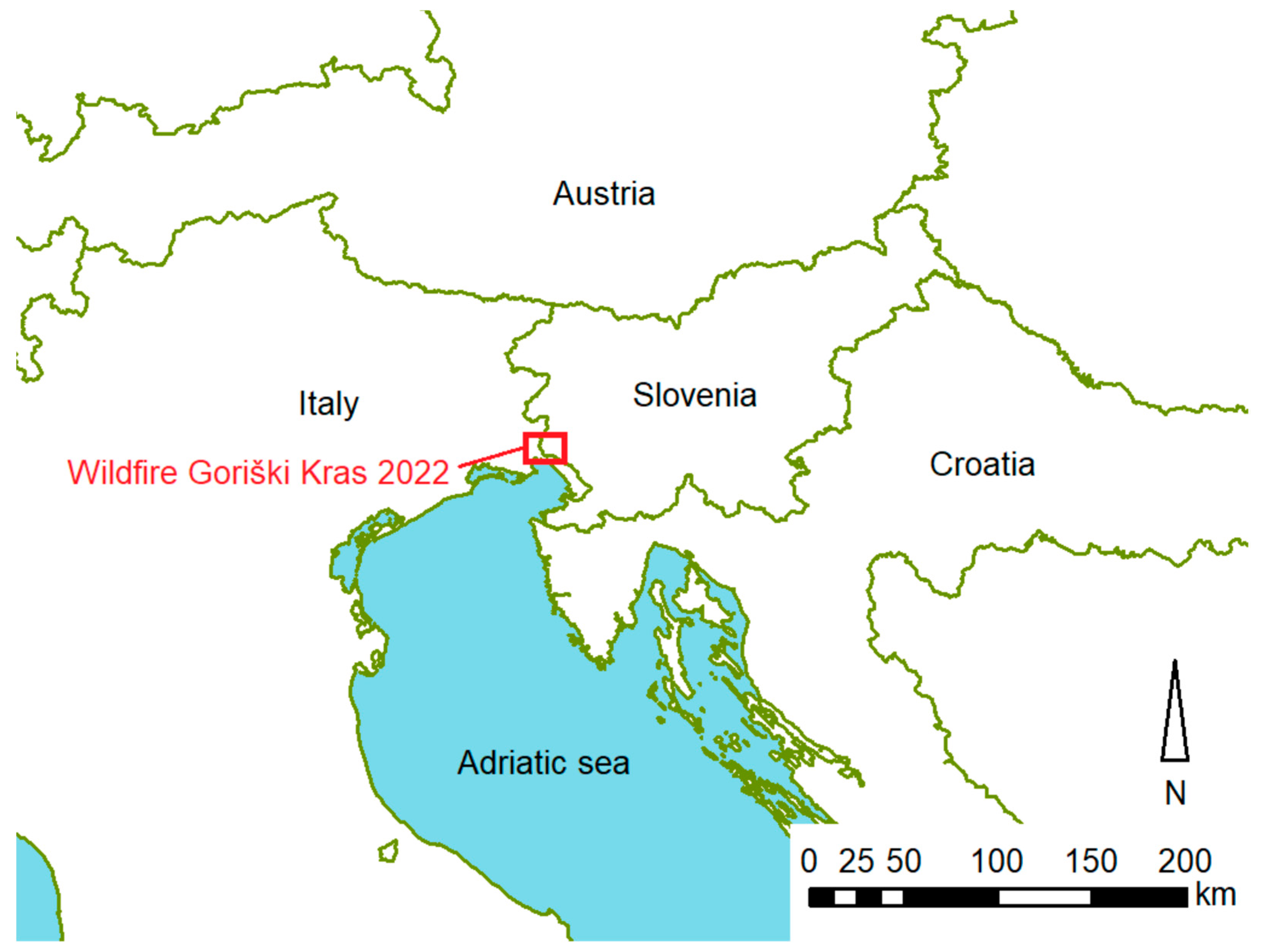
The Goriški Kras 2022 wildfire consisted of three initially completely separate wildfires that began on 15, 17, and 19 July 2022, each starting more than 5 km apart. The macro location of wildfire is presented in
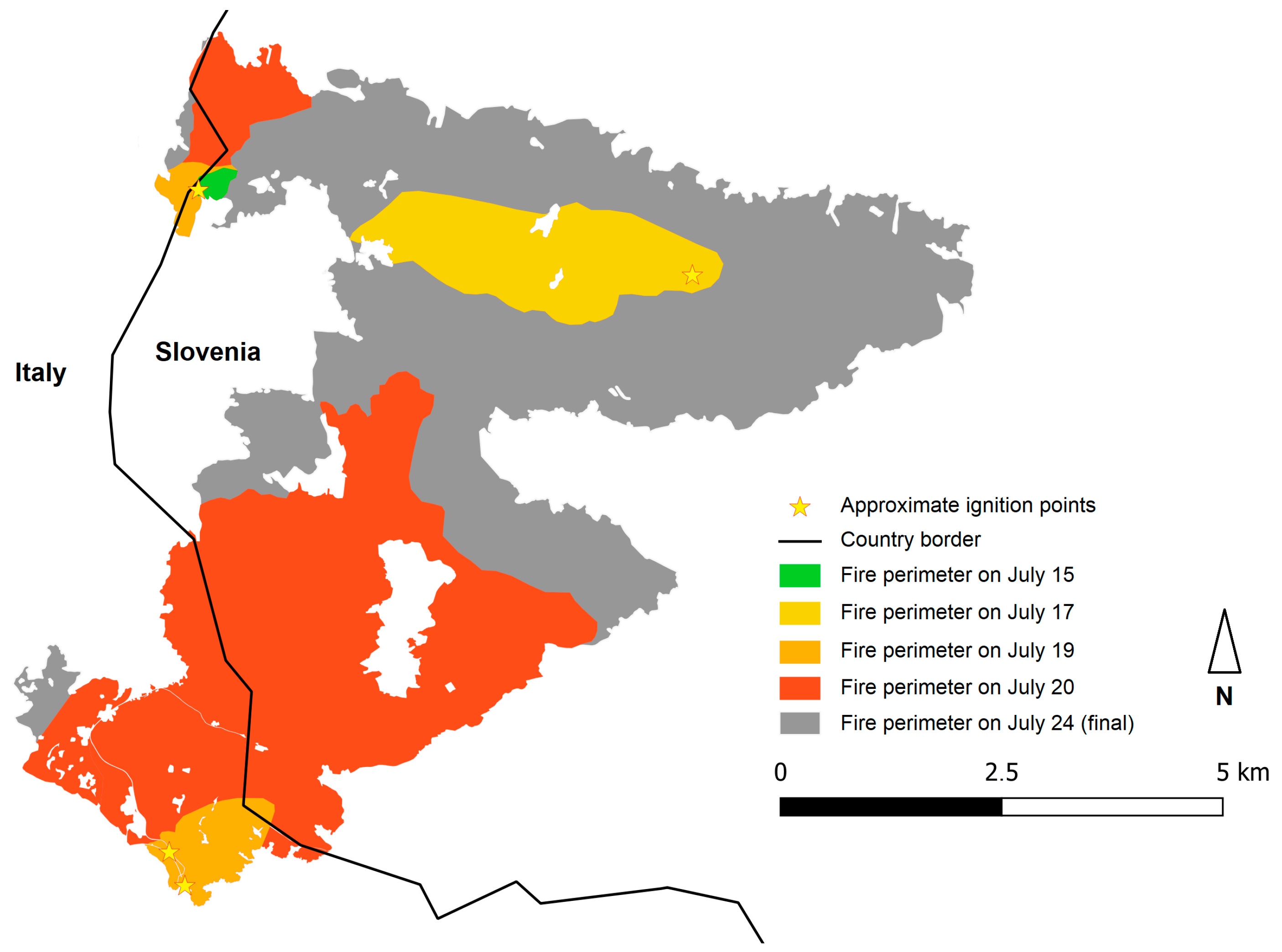
Figure 1. The highest rate of spread, exceeding 2000 m/h, was recorded on 20 July, two days before the wildfires united together. The final burned area of 4249 ha was reached on 24 July, when light rain stopped the progression. The firefighting operation concluded on 1 August. Fire progress in first days is presented in
Figure 2.
In the observed time window, during the wildfire event between 15 and 24 July, on both meteorological stations, bora and other east winds were blowing more than 70% of time. During the wildfire event, 7 days with a wildfire progression above 500 m were detected. Among them only one day (July 17) was mainly driven by the bora wind, or other east winds blowing from 60° to 140° azimuth. All 6 other days were mainly driven by south and west winds (blowing from 180° to 290° azimuth) that were blowing only about 20% of all observed time.
4. Conclusions
This sub-Mediterranean part of Slovenia is known for its strong northeast bora wind. For this reason, we aimed to determine the impact of the bora wind on the total extent of the wildfire.
Only on 17 July was the strong bora wind the main driver of wildfire spread all day long, while on other days, the bora wind alternated with south and west winds during the daytime. Since the south and west winds were slightly stronger and blew during the hottest part of the day, when FWI values were extremely high, they had a much greater impact on wildfire spread.
The majority of wildfire progression took place on the flat Karst plateau; therefore, orography was mainly not considered as an important driver.
Author Contributions
Conceptualization, visualization, investigation and writing, J.S.; investigation, writing and data curation, A.S.B. and G.O. All authors have read and agreed to the published version of the manuscript.
Funding
This research was funded by the Slovenian Research Agency, research programme P4-0107: “Forest Biology, Ecology and Technology” and the Interreg Central Europe project: Wildfire CE—Enabling cross-boundary assessment, communication and management of wildfire risks in Central Europe (CE0200934). Attendance at the conference was supported by COST action european Network on Extreme fiRe behaviOr (NERO) (CA22164).
Institutional Review Board Statement
Not applicable.
Informed Consent Statement
Not applicable.
Data Availability Statement
This abstract is part of a wider research that is under a publishing process under the working title “Saražin, Seifert Barba, Ogrin, Ogris. Impact of FWI on wildfire appearance and progression at Goriški Kras”. Wildfire isochrones and other research data will be available upon acceptance of the full article or upon request to the author.
Acknowledgments
The authors are grateful to incident commander (Slovenian side) Simon Vendramin from the Firefighting Brigade Nova Gorica.
Conflicts of Interest
The authors declare no conflicts of interest.
Abbreviations
The following abbreviations are used in this manuscript:
| FWI | Canadian fire weather index |
References
- Poljanec, A.; Rantaša, B.; Saražin, J.; Gasparič, B.; Kravanja, M.; Kolšek, M.; Košiček, B. The Public Forestry Service Role in Controlling Goriški Kras Fire and Consequences of the Fire for Forest Ecosystems. GozdVestn 2022, 80, 227–239. [Google Scholar]
- Saražin, J.; Seifert Barba, A.; Ogrin, G. Goriški Kras 2022 wildfire reconstruction—research data V1.0. Slovenian Forestry Institute, Ljubljana, Slovenia. 2026; to be published.
- European Space Agency (ESA). Sentinel-2 MSI Level-2A. Available online: https://data.destination-earth.eu/data-portfolio/EO.ESA.DAT.SENTINEL-2.MSI.L2A (accessed on 22 June 2026).
- U.S. Geological Survey. Landsat 8 OLI/TIRS Level-2 Data Products. Available online: https://www.usgs.gov/centers/eros/science/usgs-eros-archive-landsat-archives-landsat-8-olitirs-level-2-data-products (accessed on 22 June 2026).
- Vendramin, S. (Gasilska Enota Nova Gorica, Nova Gorica, Slovenia). Incident Report (SI) and Personal Communication, 2022.
- Slovenia Forest Service. Final Wildfire Perimeters. Available online: https://prostor.zgs.gov.si/pregledovalnik/?locale=sl (accessed on 22 June 2026).
- Servizio Foreste Friuli Venezia Giulia. Final Wildfire Perimeters. Available online: https://eaglefvg.regione.fvg.it/eagle/main.aspx?configuration=guest (accessed on 22 June 2026).
- Slovenian Environment Agency. Historical Wind Data from ARSO Weather Stations Bilje and Godnje. Available online: https://meteo.arso.gov.si/met/sl/archive/ (accessed on 22 June 2026).
| Disclaimer/Publisher’s Note: The statements, opinions and data contained in all publications are solely those of the individual author(s) and contributor(s) and not of MDPI and/or the editor(s). MDPI and/or the editor(s) disclaim responsibility for any injury to people or property resulting from any ideas, methods, instructions or products referred to in the content. |