1. Introduction
Large and devastating wildfires have become the most important challenge for forest fire managers today. Whereas in the last few years, with strengthened firefighting resources, they are able to control most fires in their early stages, a small number of fires that escape initial attack become catastrophic events, burning large areas, causing serious damage, and often resulting in fatalities [
1]. Avoiding fire disasters is an obvious priority, and identifying situations that are linked to a high probability that a starting fire will become large is an important task for supporting presuppression alertness and initial attack planning [
2].
Over time, wildfire research has resulted in an improved understanding of variables that influence the probability of fire starts and the potential for intense fire behavior, and has led to the development of operational systems for fire danger prediction, fire spread simulation, etc. However, there are still gaps, and perfect prediction seems elusive. Many wildfires are not controlled early and finally become large, as a result of various interacting factors of the fire environment, and, often, of firefighting failures. Any advances in understanding how certain factors, that are so far unaccounted for or are inadequately represented, affect the probability of large fire development, can be an important contribution to fire suppression effectiveness and firefighter safety.
The current work discusses one such factor: the importance of wind direction change, especially that associated with the passage of a cold front. A cold front can be defined as the transition zone or boundary between two air masses of different temperatures, where the colder air mass moves and replaces the warmer one. Meteorology textbooks and numerous research publications provide a detailed description of fronts and a mathematical analysis of the conditions for their formation and their characteristics. What is less frequently addressed is the influence cold fronts exert on wildfires. Their passage is characterized, as a rule, by strong atmospheric instability along the boundary, a sharp temperature drop, and abrupt, gusty wind shifts, usually from SW to NW (in the Northern Hemisphere), affecting fire behavior accordingly. On certain occasions, however, this abrupt wind shift may not be so evident [
3].
The fundamental knowledge on the subject is not new, as the link between cold fronts and high fire danger was identified quite early by various meteorologists in the USA, such as [
4,
5], who further discussed the major fire weather patterns in each of 14 regions of the country. Also, ref. [
6], in a seminal publication that has formed the basis for further training material of fire managers, defined the concept of fire weather and presented, in a clear and concise way, the link between weather phenomena and their influences on wildland fire. The passage of a cold front received special attention.
International scientific literature includes numerous investigations on the influence of cold fronts on wildfires in the USA, Australia, Canada and Europe [
7,
8,
9,
10,
11] and provides detailed documentation and analysis of specific fires that became large and dangerous under the passage of a cold front. Example events include:
The fire that started on 2 June 1996, 50 km from Anchorage, Alaska, and flared up on 3 June with the passage of a cold front, becoming the Miller’s Reach fire, continued to burn 15,100 ha in the next two days [
12].
The Västmanland wildfire broke out on the afternoon of 31 July 2014 on the border between Sala Municipality and Surahammar Municipality in Sweden. It grew exponentially on 3 August, with the passage of a cold front. It continued until 13 August, finally burning 15,000 ha [
13].
The fire that, on 3–4 May 2016, with the passage of a cold front, swept through the city of Fort McMurray in Alberta, Canada [
9,
10,
11,
12,
13,
14]. It grew extremely fast, forcing the evacuation of 88,000 people, and was not controlled until 15 July 2016, burning 590,000 ha.
While it is rational that the sudden change in wind direction associated with the passage of a cold front is likely to turn the SE flank of a spreading fire into a new front within a few minutes, resulting in quick and dangerous growth, this knowledge and especially the capability of meteorologists to predict the arrival of the fronts is not fully exploited. Although most wildfire professionals receive relevant training, it seems that in many countries the importance of the phenomenon is not adequately factored into current fire danger prediction systems and in firefighting practice, increasing the probability of fire suppression failures.
This work does not aim to provide a comprehensive meteorological analysis of cold fronts, but rather to highlight the significance of their arrival on the progression of wildfires, with a focus on Greece. The interest in the work stems from a 30-year observation and analysis of selected wildfire events in Greece that have become large under the influence of a cold front, which, added to a small number of selected examples from other countries, helps illustrate and bring attention to the issue, especially in regard to anticipation and operational response. The objective is to learn from these experiences, to be better prepared in the future.
2. Materials and Methods
Aiming to illustrate the serious influence that the passage of a cold front can have on the spread of a wildfire, the main characteristics are explained first, as they are manifested in Greece, specifically during the fire season. This is followed by a brief presentation of selected fires in Greece that became large under such conditions, presenting their final burned area and indicating with arrows the approximate sequence of fire spread, as noted by the authors at the time of the events, collecting information from various sources: personal involvement, discussions with fire managers and firefighters, media reports, meteorological data, fire statistics, scientific publications, etc. As these fires span a duration of three decades, the sources of the burned area images and, accordingly, their quality vary, but they are adequate for illustration of the main points. The examples help illustrate the problem, leading to a discussion and proposals for a better response.
3. Results
3.1. Cold Fronts over Greece in the Summer
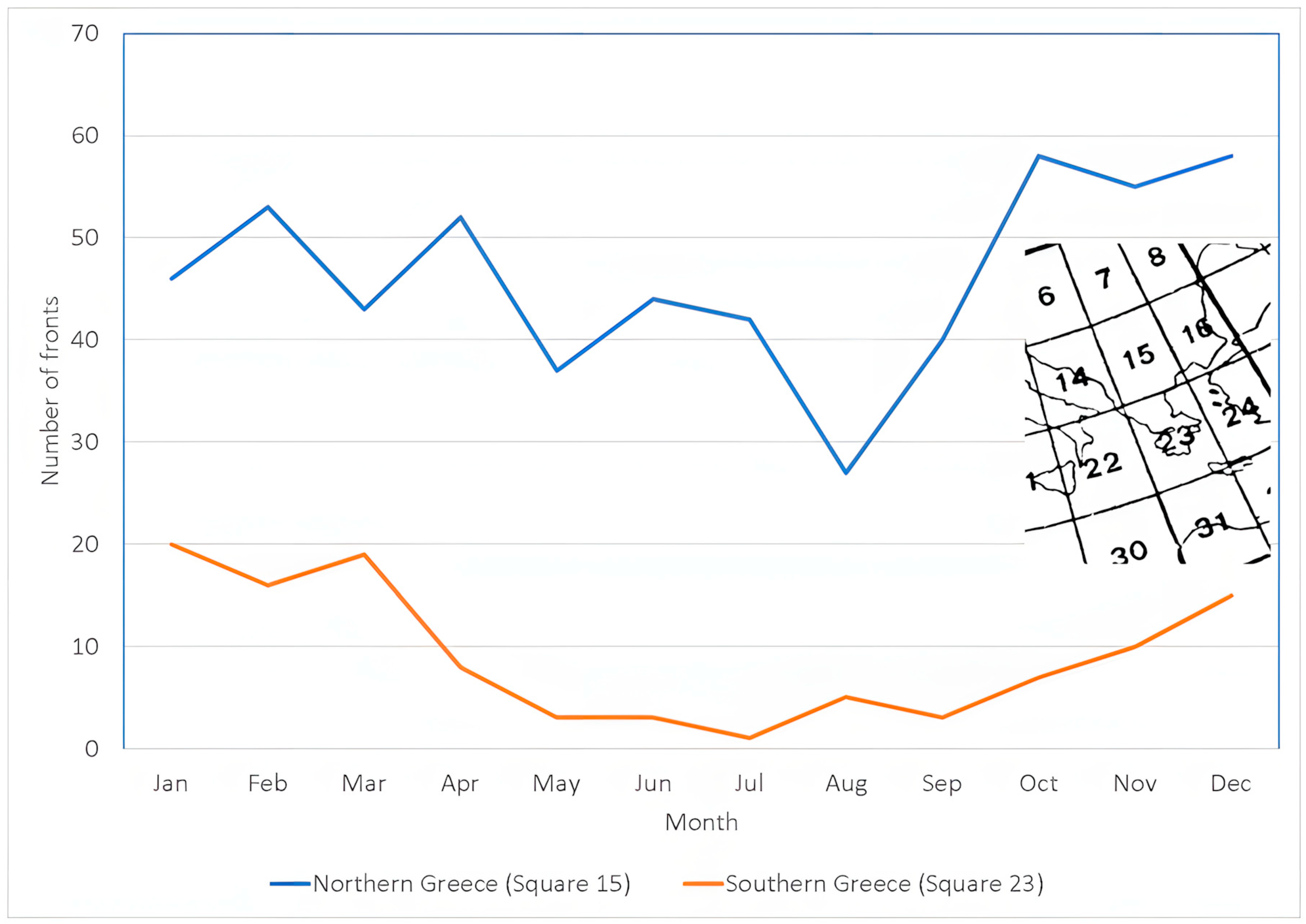
In Greece, it is not uncommon to experience passage of cold fronts in the summer; they arrive from the west, but their frequency is much lower than in the other seasons. Also, there is a distinct frequency difference between the north and the south of the country, with the number being much higher in the north (
Figure 1) [
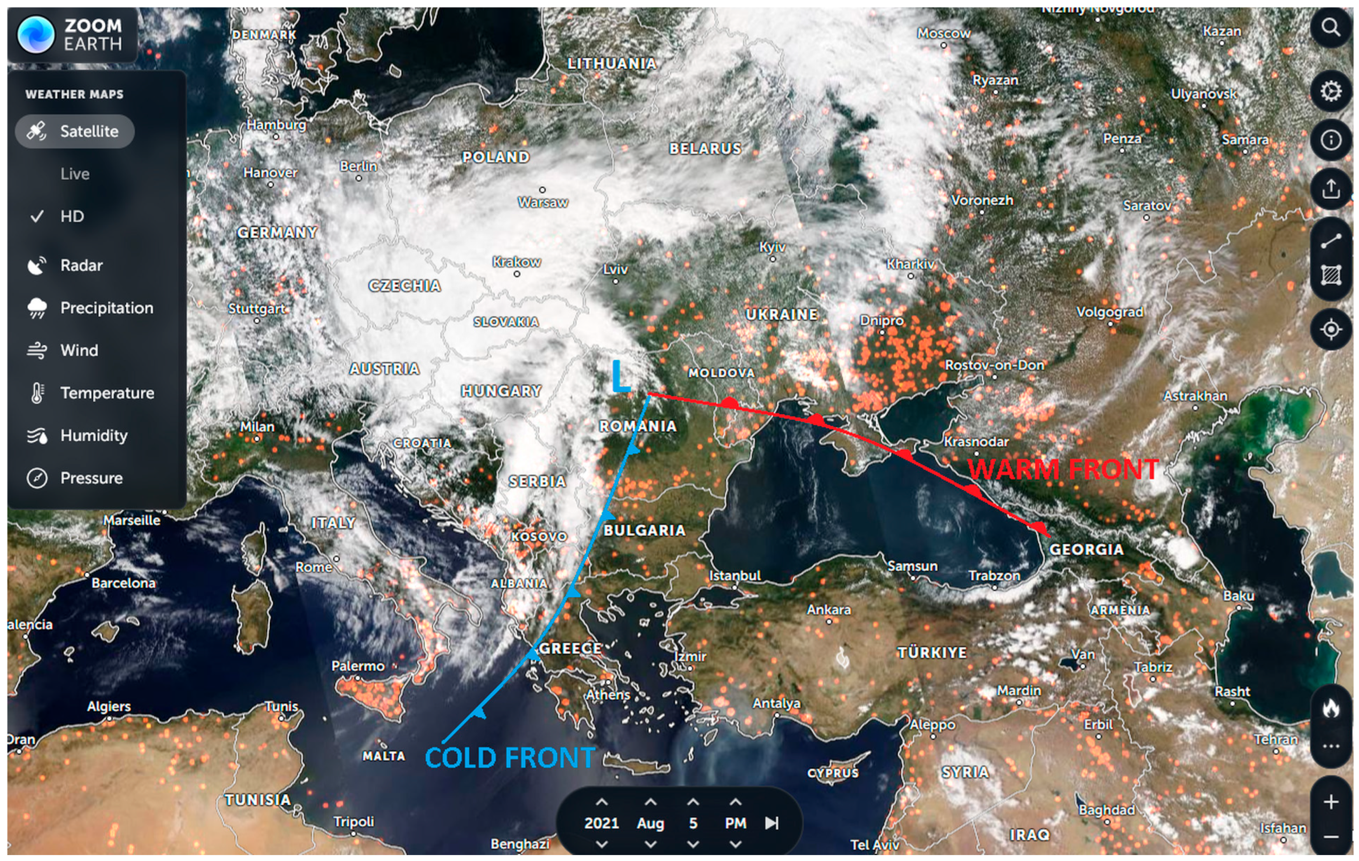
15]. More importantly, the cold fronts recorded in the south are quite often the dry “trailing end” of a large cold front that brings rain to the Balkan countries to the north, and sometimes even to the northern part of Greece (
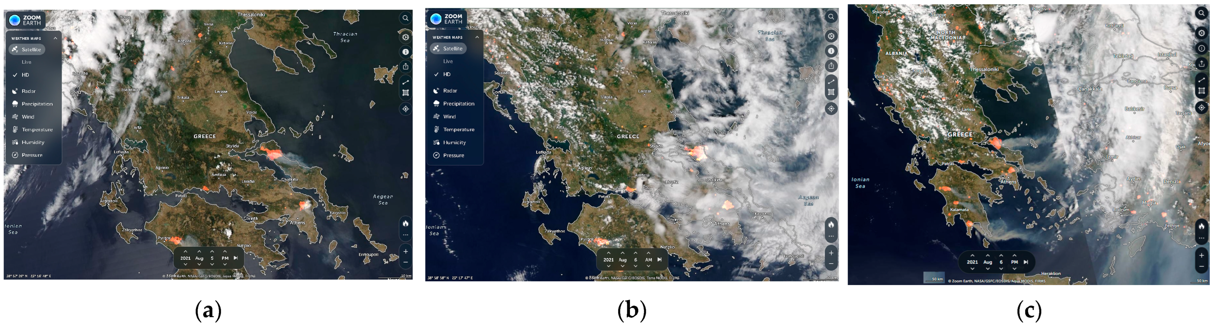
Figure 2). In that case, wildfires in the parts of the country that do not receive rain but only experience the shift in the SW wind preceding the front to a NW wind within a few minutes often escape initial attack and become very large.
3.2. Examples of Large Wildfires Associated with the Passage of a Cold Front in Greece
The wildfires presented here (
Figure 2,
Figure 3,
Figure 4,
Figure 5,
Figure 6,
Figure 7 and
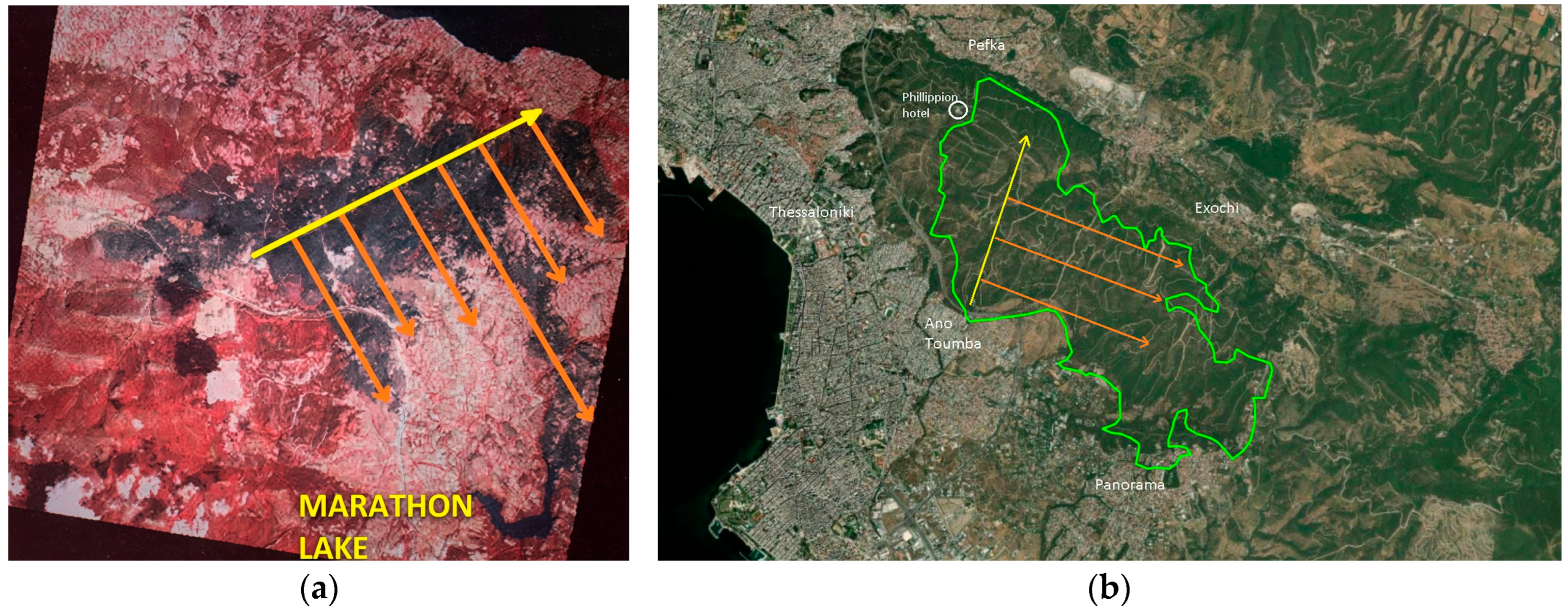
Figure 8) had erupted and started growing towards the NE before the arrival of a cold front. This is indicated in the figures with yellow arrows. The spread towards the SE, after the wind shift, is shown with orange arrows. Although the strong wind lasts only for a few hours after the passage, the burned area grows quickly, depending on the length of the SE flank of the fire at the time of the wind shift.
3.2.1. The Fire of Avlonas, 5 September 1992
The fire started near the Avlonas landfill in Attica, where trash was being burned. The southwesterly wind that preceded the arrival of the fire front carried burning embers that started the fire about 300 m from the landfill. The fire initially moved northeast, crossing the Athens–Thessaloniki national highway, which at the time was under construction (yellow arrow) (
Figure 3a). Shortly thereafter, the wind shifted to the northwest, and the southern flank of the fire rapidly transformed into a long fire front that moved southeast (orange arrows), once again crossing the national highway and burning a vast area in just a few hours. One of the fingers of this front reached Lake Marathon. A total of 6000 ha of mostly
Pinus halepensis forest were burned, about half of which were consumed in the first six hours after the fire started.
3.2.2. The Fire of the Forest Park of Thessaloniki, 6 July 1997
The fire of the forest park of Thessaloniki started near the suburb of Ano Toumba at 3:35 p.m., with a temperature of 39 °C and a southwesterly wind. The fire front initially spread through the
Pinus brutia forest in a N-NE direction, threatening the Philippion hotel and the suburb of Pefka (yellow arrow) (
Figure 3b). Ground forces attempted unsuccessfully to contain the front, as aerial support was not immediately available. Shortly before 7:00 p.m., as a cold front passed and the wind became NW, the initial expressions of relief from the media that the “Philippion hotel was saved” turned into cries of anguish as the SE flank of the fire transformed into a front that spread rapidly toward the suburb of Panorama (orange arrows), reaching the base of the hill in the early hours of the night. At that time, the wind died down, and the rapid spread of the fire ceased. The fire was finally extinguished the following day after burning 1700 ha of forest.
3.2.3. Fires in Attica and Surrounding Prefectures, 4 July 1998
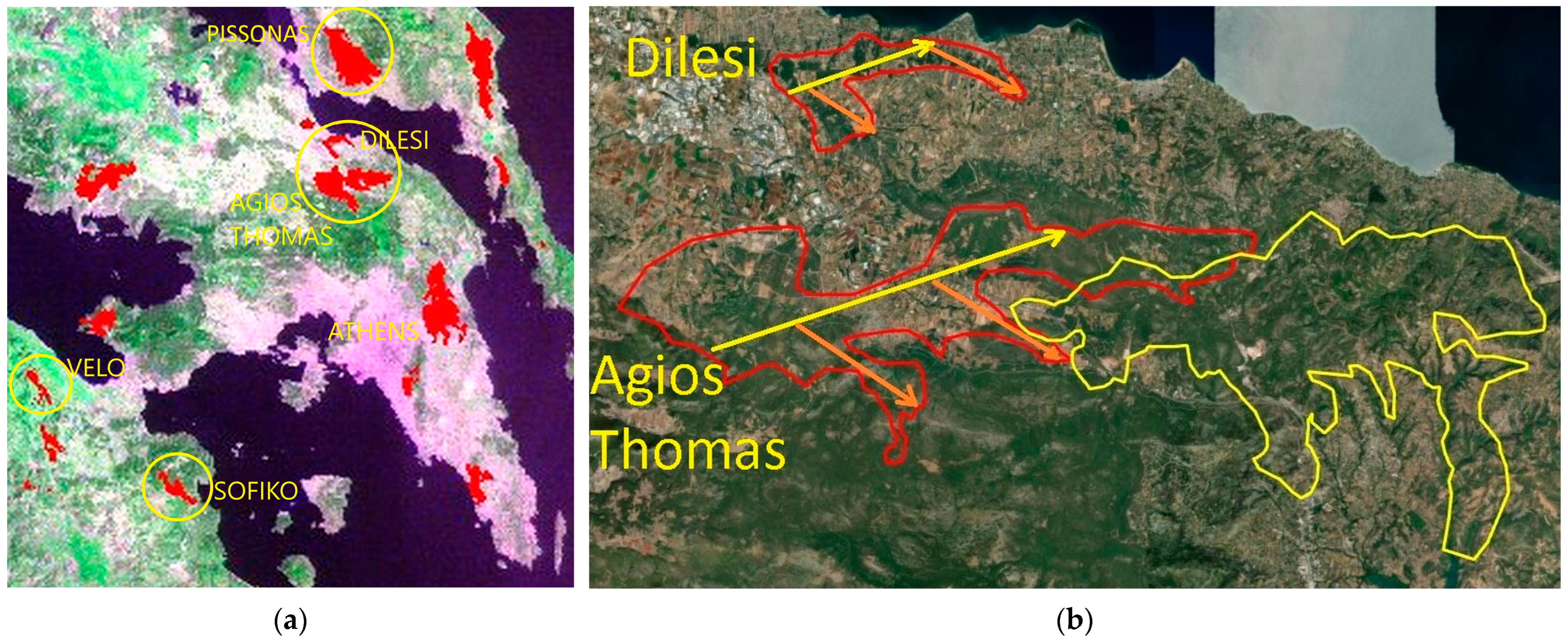
Early in the afternoon of 4 July 1998, following four days of high temperatures—exceeding 40 °C—low atmospheric humidity, and calm winds, the passage of a cold front came as a huge surprise to the Fire Service, which had just assumed responsibility for forest firefighting in Greece. 4 July was a Saturday, and for many residents of large cities, it was the first day of their vacation. The lull fooled many people into starting to clean their yards by burning weeds and branches, as well as lighting barbecues. Shortly before noon, the wind began to pick up from the southwest, reaching 5–6 Beaufort and starting many fires. Just before 14:00, the wind shifted from the NW, its speed reached 7 Beaufort, and fire fingers began moving toward the southeast, burning large areas in a short time. According to the newspaper “To Vima”, “over the weekend of 4 and 5 July alone, there were 180 fires (27 of them in Attica). Of these, 125 broke out on Saturday, 4 July, between 13:00 and 14:00 h”. Approximately 25 of the fires were caused by the burning of garbage dumps, according to an official statement [
16]. As the cold front passed through Corinthia, Attica, Boeotia, and Euboea during the hottest hours of the day, the largest fires developed in those areas. Notable examples include the fires that started in Ano Diminio, Velo, and Sofiko in Corinthia and in Pissonas in Euboea (
Figure 4a), as well as those in Agios Thomas and Dilesi in Boeotia (
Figure 4b). The progression of the fires after the wind shift is shown with orange arrows. It should be noted that the fire in Sofiko had been burning for several days prior to 4 July without being fully extinguished, and reignited with the passage of the cold front. Due to fire entrapments, there were three citizen fatalities and three serious injuries, including one firefighter.
3.2.4. Fires in Northern Peloponnese, 12–13 July 2000
The passage of a cold front on 13 July 2000 caused massive destruction in the northern part of the Peloponnese.
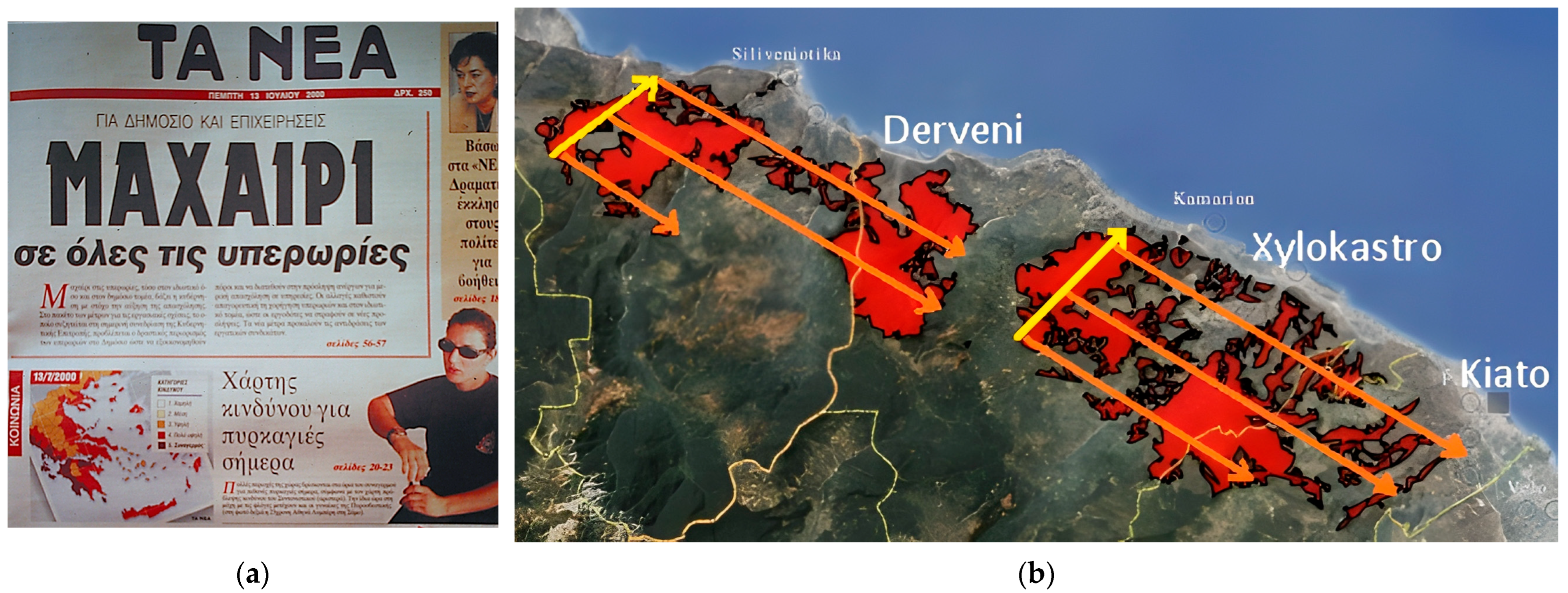
Figure 5a shows the fire danger prediction map issued at noon on 12 July 2000, by the Fire Service Coordination Center (prepared by the first author) and valid for 13 July 2000. The forecast, which took into account the imminent arrival of the cold front, predicted maximum fire danger level (category 5, red-flag alert) for Corinthia and very high fire danger (category 4) for the Aigio Forest District to the west. The forecast proved accurate in both areas, with two highly destructive fires: the fire of Ano Diakopto, Aegialia, and the fire of Ano Pitsa, Corinthia (
Figure 5b).
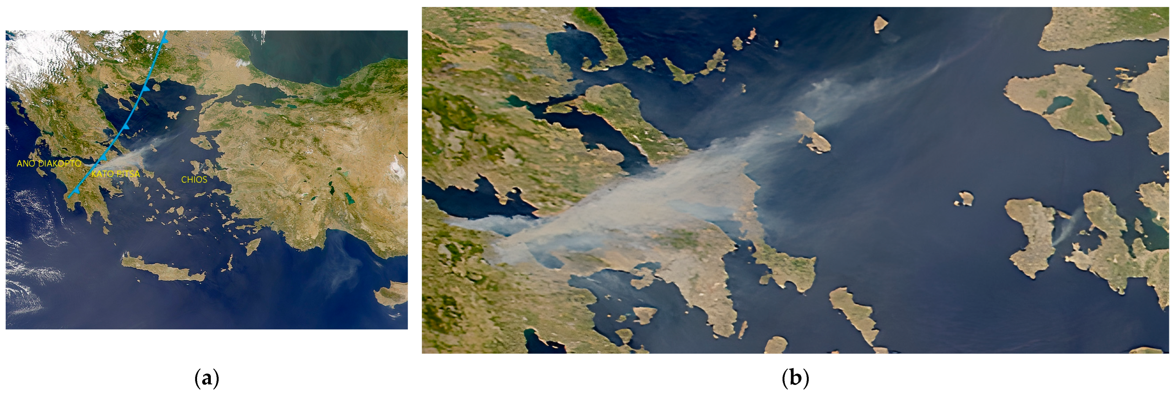
In the satellite image from 13 July 2000, taken by NASA’s ORBVIEW 2 (
Figure 6a), the approximate location of the cold front at the time the image was captured has been plotted, based on the change in direction of the smoke plumes from the two fires. It can be seen that north of Greece, the cold front is accompanied by clouds and possibly thunderstorms, while this is not the case along its “tail” over Greece.
Figure 6b is an enlargement of a section of
Figure 6a, where the smoke plume from a fire on Chios to the east is visible. There, the wind is blowing from a clearly SW direction, while the smoke plume from the fire in Ano Diakopto has shifted to the SE as it is already being affected by a NW wind following the arrival of the cold front. In contrast, the front has not yet reached the fire in Corinthia, where the wind is still blowing from the SW, and the smoke is spreading toward the NE.
Despite the forecast and the efforts for maximum alert of the Fire Service, the two fires that broke out on the afternoon of 12 July—in Aegialia near Ano Diakopto, and in Corinthia in the area of the village Ano Pitsa—could not be brought under control by the following morning. The increase in wind speed from the southwest late in the afternoon of 12 July, before the front arrived (yellow arrows in
Figure 5b), drove the two fires toward the coast of the Gulf of Corinth, while the wind’s “shift” to the northwest in the morning of 13 July and its significant intensification (7–8 Beaufort) drove the two fronts toward the southeast, into the mountainous area parallel to the coastline (orange arrows in
Figure 5b). The fire in Ano Diakopto almost merged with the fire in Corinthia. The burned area quickly became very large. Within a single day, the fire in Corinthia burned 20,000 ha, while the fire in Aegialia exceeded 10,000 ha.
3.2.5. The Fire of Northern Euboea, 3–10 August 2021
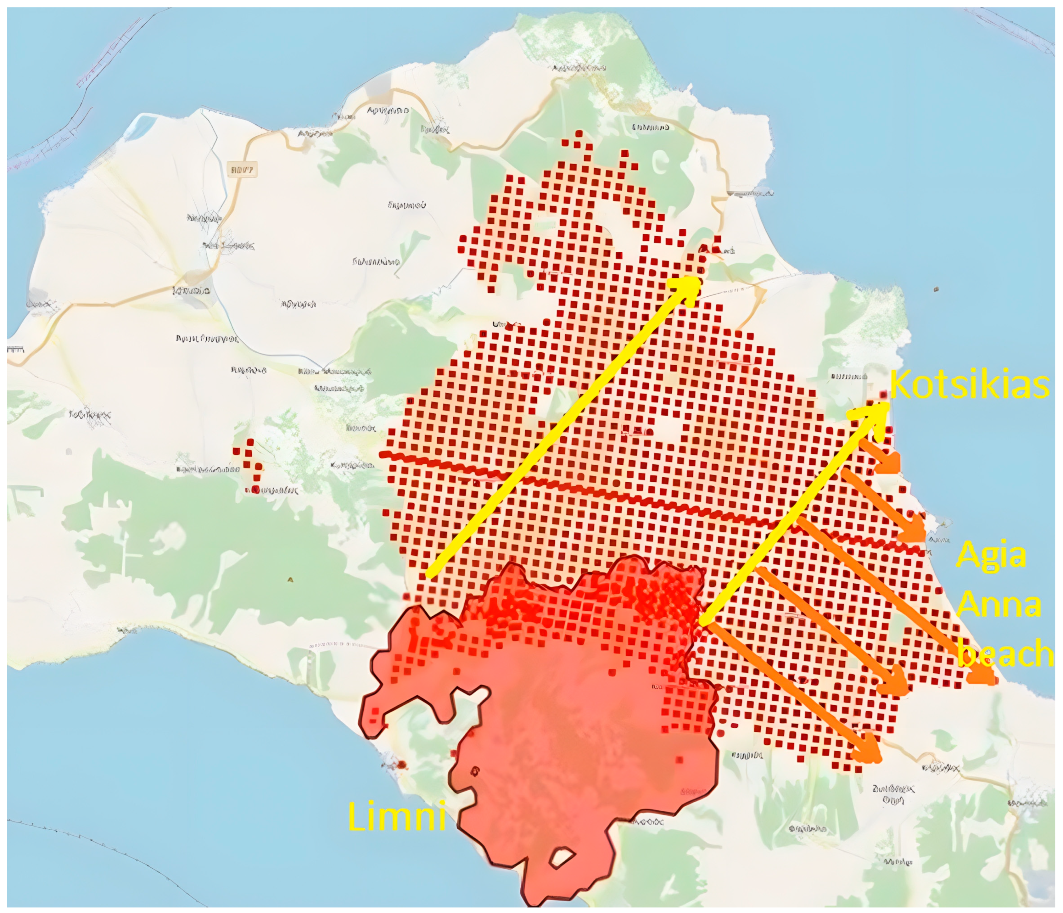
The fire of Northern Euboea began under heatwave conditions on 3 August 2021 near the town of Limni and continued spreading until 11 August. As it lasted for many days, it was influenced by various meteorological conditions that, combined with ineffective firefighting, resulted in a burned area of 55,000 ha, setting a new record for the country. Of particular significance among these conditions was the passage of a cold front [
17] that reached Greece in the evening hours of 5 August , and affected the fire during that night (
Figure 7a–c).
In
Figure 7a, the cold front can be seen over the Pindus mountain range in the evening of 5 August, while the column of smoke from the Northern Euboea fire indicates that it is being affected by a NW wind. In the early hours of the night, before the front arrived, the wind became SW and intensified. Thus, during the night, the fire created a rapidly moving front toward the northeast, reaching as far as Kotsikia Beach, north of Agia Anna Beach. Subsequently, with the passage of the front, the wind shifted from the NW, driving the fire toward the southeast, and burning through the settlement and tourist facilities at Agia Anna Beach by 6 August.
Figure 8 illustrates the fire’s movement before the arrival of the cold front (yellow arrows) and after its passage (orange arrows) on an image from the European Commission’s Copernicus Service, which shows (approximately) in red the area burned by the fire as of 5 August, while the red dots indicate the fire’s progression as of 6 August.
4. Discussion
The fires described above clearly illustrate the magnitude of the challenge posed by the arrival of a cold front in a fire area and its potential to cause rapid spread and extensive burn areas within a few hours. To effectively respond to an advancing cold front, those involved in wildland firefighting—and especially those in a coordinating role—must:
Be familiar with the characteristics of a cold front as described above.
Be informed in a timely manner of the front’s arrival time. This may require targeted updates from the coordination center, which should utilize not only meteorological predictions but also the existing network of weather stations across the country, monitoring the shift in wind direction from SW to NW—an indication that the front has reached that station as it moves eastwards (for example, the station of Corfu in Greece).
Make every effort to completely extinguish any fire that starts or is already burning before the arrival of the cold front.
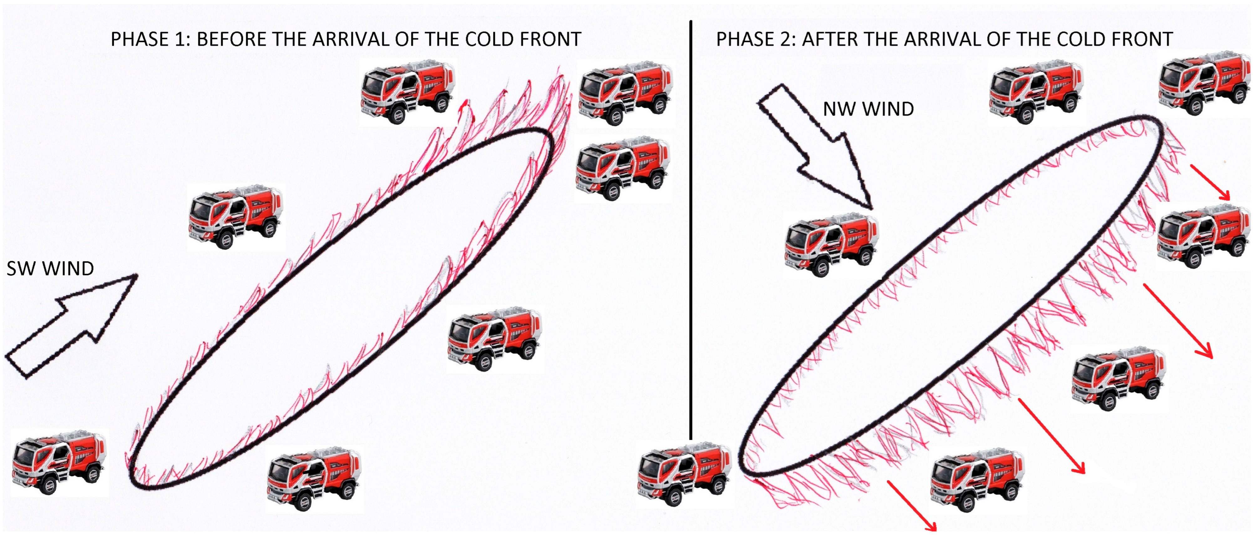
If it is not possible to fully extinguish an ongoing fire, or in the event of a new fire as the fire front approaches, the incident commander should immediately plan a response, taking into account the expected change in wind direction. Specifically, before the wind shifts to the SW and begins to strengthen, emphasis must be placed on extinguishing the S-SE-E section of the perimeter. The W-NW-N section of the perimeter requires relatively less attention. The S-SE flank requires the utmost attention and effort. In particular, when the fire begins to spread toward the NE, just before the arrival of the cold front, extinguishing efforts in the SE-S section of the perimeter must be maximized. The effort must begin from a safe “anchor” point at the SW end of the perimeter and proceed along the S-SE-E-NE flank, with continuous advancement of the forces without “leaving” gaps between them, since a shift in the wind to NW will suddenly create fire fronts (fire fingers) moving toward the southeast, that is, toward their position. If there are gaps between fire trucks or firefighter crews at work, there is a significant risk that these fingers will pass between them, putting them at risk of entrapment. It is emphasized that along the S-SE flank, firefighting operations must be active, working on the flames, rather than waiting on roads parallel to the perimeter, because if the wind changes direction, the fire will have the opportunity to create a front toward the firefighters. If a firebreak is created using manual or mechanical means at a distance from the S-SE flank, the same risk exists; therefore, if conditions permit, while the wind is still blowing from the southwest, the vegetation between the firebreak and the flank of the fire should be burned out.
Consider, while planning response, the spatial distribution of vegetation and fuels in forested and agricultural areas, identifying locations where the expected changes in the direction of the fire front will provide opportunities for containment, as well as safety zones for personnel in case of danger.
Inform personnel so that they can anticipate changes and be aware of opportunities for containment, escape routes, and safety zones in case of danger.
Figure 9 illustrates, conceptually, the wind shift with the passage of a cold front, the associated change in fire spread direction, and the problems and safety issues for the firefighters along the SE flank of the fire.
One instance in which the above guidelines were applied, with positive results, was the Sykaminos–Kalamos fire on 4 June 2001, which was affected by the passage of a cold front. By focusing efforts on the S-SE flank of the fire perimeter, with the task assigned explicitly to a high-ranking officer of the Fire Service, when the wind shifted to the NW, there was no development of a fire front in a SE direction, similar to the one of the fire of Avlonas in 1992, in roughly the same area. The total burned area reached 340 ha [
18].
5. Conclusions
The examples shown here verify the high fire danger associated with the passage of a cold front. All personnel involved in fire suppression should be trained on how to anticipate it and react. Fire meteorologists should forecast the passage, noting the expected time of arrival at each fire.
It should be noted that although it is a well-known phenomenon, it is not easy to identify its influence through statistical analysis of existing datasets because the timing of the passage, the stage of the fire at the time, and the success of informed firefighters confound the outcome. Thus, it may be underrepresented among the factors that are currently considered in fire danger predictions.
Author Contributions
Conceptualization, G.X. and M.A.; methodology, G.X.; validation, G.X., M.A. and K.K.; formal analysis, G.X.; investigation, G.X., M.A. and K.K.; resources, G.X.; data curation, G.X.; writing—original draft preparation, G.X.; writing—review and editing, M.A. and K.K.; visualization, G.X. and K.K.; supervision, G.X.; project administration, G.X.; funding acquisition, G.X. All authors have read and agreed to the published version of the manuscript.
Funding
This paper was prepared in the framework of the ResAlliance project “Landscape resilience knowledge alliance for agriculture and forestry in the Mediterranean basin”, funded by the European Commission, European Research Executive Agency (REA), under the Horizon Europe Framework Programme (Project 101086600).
Institutional Review Board Statement
Not applicable.
Informed Consent Statement
Not applicable.
Data Availability Statement
All data generated or used during the study appear in the article.
Conflicts of Interest
The authors declare no conflicts of interest.
References
- Tedim, F.; Leone, V.; Amraoui, M.; Bouillon, C.; Coughlan, M.; Delogu, G.; Fernandes, P.; Ferreira, C.; McCaffrey, S.; McGee, T.; et al. Defining Extreme Wildfire Events: Difficulties, Challenges, and Impacts. Fire 2018, 1, 9. [Google Scholar] [CrossRef] [Scilit]
- Pérez-Porras, F.-J.; Triviño-Tarradas, P.; Cima-Rodríguez, C.; Meroño-de-Larriva, J.-E.; García-Ferrer, A.; Mesas-Carrascosa, F.-J. Machine Learning Methods and Synthetic Data Generation to Predict Large Wildfires. Sensors 2021, 21, 3694. [Google Scholar] [CrossRef] [Scilit] [PubMed]
- Schultz, D.M. Cold fronts with and without prefrontal wind shifts in the central United States. Mon. Weather Rev. 2004, 132, 2040–2053. [Google Scholar] [CrossRef]
- Show, S.B. Meteorology and the forest fire problem. Mon. Weather Rev. 1931, 59, 432–433. [Google Scholar] [CrossRef]
- Schroeder, M.J.; Glovinsky, M.; Hendricks, V.F.; Hood, F.C.; Hull, M.K. Synoptic Weather Types Associated with Critical Fire Weather; Technical Report; Pacific Southwest Forest and Range Experiment Station: Berkeley, CA, USA, 1964. [Google Scholar]
- Schroeder, M.J.; Buck, C.C.; Buck, C.C. Fire Weather: A Guide for Application of Meteorological Information to Forest Fire Control Operations; No. 360; US Department of Agriculture, Forest Service: Washington, DC, USA, 1970.
- Brotak, E.A.; Reifsnyder, W.E. An investigation of the synoptic situations associated with major wildland fires. J. Appl. Meteorol. 1977, 16, 867–870. [Google Scholar] [CrossRef] [PubMed]
- Abram, N.J.; Henley, B.J.; Sen Gupta, A.; Lippmann, T.J.R.; Clarke, H.; Dowdy, A.J.; Sharples, J.J.; Nolan, R.H.; Zhang, T.; Wooster, M.J.; et al. Connections of climate change and variability to large and extreme forest fires in southeast Australia. Commun. Earth Environ. 2021, 2, 8. [Google Scholar] [CrossRef] [Scilit]
- Tymstra, C.; Jain, P.; Flannigan, M.D. Characterisation of initial fire weather conditions for large spring wildfires in Alberta, Canada. Int. J. Wildland Fire 2021, 30, 823–835. [Google Scholar] [CrossRef] [Scilit]
- Cai, D.; Abram, N.J.; Sharples, J.J.; Perkins-Kirkpatrick, S.E. Increasing intensity and frequency of cold fronts contributed to Australia’s 2019–2020 Black Summer fire disaster. Environ. Res. Lett. 2022, 17, 094044. [Google Scholar] [CrossRef] [Scilit]
- Magaritz-Ronen, L.; Raveh-Rubin, S. Tracing the formation of exceptional fronts driving historical fires in Southeast Australia. npj Clim. Atmos. Sci. 2023, 6, 110. [Google Scholar] [CrossRef] [Scilit]
- Hufford, G.L.; Kelley, H.L.; Sparkman, W.; Moore, R.K. Use of real-time multisatellite and radar data to support forest fire management. Weather Forecast. 1998, 13, 592–605. [Google Scholar] [CrossRef]
- Petroliagkis, T.; Liberta, G.; Artes, T.; Rodriguez-Aseretto, D.; di Leo, M.; San-Miguel-Ayanz, J. Stability of Atmospheric Flow and Low-Level Jets Influencing Forest Fire Behavior—An EFFIS Report. EUR—Sci. Tech. Res. Ser. 2015, 27362, 30. [Google Scholar]
- Ahmed, M.R.; Hassan, Q.K.; Abdollahi, M.; Gupta, A. Introducing a new remote sensing-based model for forecasting forest fire danger conditions at a four-day scale. Remote Sens. 2019, 11, 2101. [Google Scholar] [CrossRef] [Scilit]
- Flocas, A.A. The annual and seasonal distribution of fronts over central-southern Europe and the Mediterranean. J. Climatol. 1984, 4, 255–267. [Google Scholar] [CrossRef] [Scilit]
- Xanthopoulos, G. The 1998 forest fire season in Greece: A forest fire expert’s account. Int. For. Fire News (ECE/FAO) 1999, 20, 57–60. [Google Scholar]
- Giannaros, T.M.; Papavasileiou, G.; Lagouvardos, K.; Kotroni, V.; Dafis, S.; Karagiannidis, A.; Dragozi, E. Meteorological Analysis of the 2021 Extreme Wildfires in Greece: Lessons Learned and Implications for Early Warning of the Potential for Pyroconvection. Atmosphere 2022, 13, 475. [Google Scholar] [CrossRef] [Scilit]
- Xanthopoulos, G.; Labris, C.; Golfinos, C. The June 4, 2001 fire in the wildland urban interface areas of Northern Attica: Evolution, firefighting problems and damages. In Proceedings of the International Workshop on “Forest Fires in the Wildland-Urban Interface and Rural Areas in Europe: An integral planning and management challenge”, Athens, Greece, 15–16 May 2003. [Google Scholar]
Figure 1.
Total number of fronts per month in northern Greece and southern Greece (squares 15 and 23 of the map insert, respectively), during the 1971–1979 period (Data are available in ref. [
15]).
Figure 1.
Total number of fronts per month in northern Greece and southern Greece (squares 15 and 23 of the map insert, respectively), during the 1971–1979 period (Data are available in ref. [
15]).
Figure 2.
Arrival of a cold front over Greece on 5 August 2021 (Satellite image: NASA Zoom Earth).
Figure 2.
Arrival of a cold front over Greece on 5 August 2021 (Satellite image: NASA Zoom Earth).
Figure 3.
Influence of the passage of a cold front over (a) the 6000 ha fire of Avlonas, Attica, 5 September 1992; (b) the 1700 ha fire of the forest park of Thessaloniki, 6–7 July 1997.
Figure 3.
Influence of the passage of a cold front over (a) the 6000 ha fire of Avlonas, Attica, 5 September 1992; (b) the 1700 ha fire of the forest park of Thessaloniki, 6–7 July 1997.
Figure 4.
(a) The fires of 4 July 1998 (Velo, Sofiko, Dilesi, Agios Thomas & Pissonas), indicated by circles, showing a spread towards the SE after the passage of the cold front. (b) The fires of Dilesi and Agios Thomas (Boeotia) are indicated with a red perimeter; the perimeter of the fire of Avlonas of 5 September 1992, is shown in yellow for comparison.
Figure 4.
(a) The fires of 4 July 1998 (Velo, Sofiko, Dilesi, Agios Thomas & Pissonas), indicated by circles, showing a spread towards the SE after the passage of the cold front. (b) The fires of Dilesi and Agios Thomas (Boeotia) are indicated with a red perimeter; the perimeter of the fire of Avlonas of 5 September 1992, is shown in yellow for comparison.
Figure 5.
(a) The fire danger prediction map for 13 July 2000, published on the front page of the 13 July 2000 issue of the newspaper “TA NEA”, ranking the area of Aigio, Achaia, as Class 4 (very high fire danger) and the area of Corinthia as Class 5 (maximum—red flag alert). (b) The spread of the Ano Diakopto (Achaia) and Kato Pitsa (Corinthia) fires along the north coast of Peloponnese, which burned approximately 30,000 ha on 12–13 July 2000 (Image source: National Observatory of Athens, BEYOND Excellence Center, FireHub).
Figure 5.
(a) The fire danger prediction map for 13 July 2000, published on the front page of the 13 July 2000 issue of the newspaper “TA NEA”, ranking the area of Aigio, Achaia, as Class 4 (very high fire danger) and the area of Corinthia as Class 5 (maximum—red flag alert). (b) The spread of the Ano Diakopto (Achaia) and Kato Pitsa (Corinthia) fires along the north coast of Peloponnese, which burned approximately 30,000 ha on 12–13 July 2000 (Image source: National Observatory of Athens, BEYOND Excellence Center, FireHub).
Figure 6.
Satellite image of 13 July 2000, from NASA’s ORBVIEW 2 satellite. (a) The approximate location of the cold front at the time of acquisition is plotted with a blue line. Wind direction at the fire on Chios island to the east is SW. The smoke column of the fire in Kato Pitsa, Corinthia, ahead of the cold front, is also driven by a SW wind. However, the column of the Ano Diakopto, Achaia, fire, 25 km to the west, illustrates the change in wind direction to NW, exactly after the passage of the cold front. (b) Detailed view of the three smoke columns.
Figure 6.
Satellite image of 13 July 2000, from NASA’s ORBVIEW 2 satellite. (a) The approximate location of the cold front at the time of acquisition is plotted with a blue line. Wind direction at the fire on Chios island to the east is SW. The smoke column of the fire in Kato Pitsa, Corinthia, ahead of the cold front, is also driven by a SW wind. However, the column of the Ano Diakopto, Achaia, fire, 25 km to the west, illustrates the change in wind direction to NW, exactly after the passage of the cold front. (b) Detailed view of the three smoke columns.
Figure 8.
The evolution of the N. Euboea fire during the night of 5 to 6 August 2021 and in the following morning. The solid color depicts the burned area before the passage of the front and the dotted area shows the spread during the night and in the early morning hours of 6 August as the wind became initially SW and then turned to NW. (source: Post of 6 August on eviaportal.gr,
https://eviaportal.gr/ekseliksi-fotias-evvoia-apo-doryforiko-systima-copernicus-paraskevi-6-avgoustou/ (assessed on 9 August 2026).
Figure 8.
The evolution of the N. Euboea fire during the night of 5 to 6 August 2021 and in the following morning. The solid color depicts the burned area before the passage of the front and the dotted area shows the spread during the night and in the early morning hours of 6 August as the wind became initially SW and then turned to NW. (source: Post of 6 August on eviaportal.gr,
https://eviaportal.gr/ekseliksi-fotias-evvoia-apo-doryforiko-systima-copernicus-paraskevi-6-avgoustou/ (assessed on 9 August 2026).
Figure 9.
Conceptual drawing of the effect of the wind shift on fire spread and on firefighting.
Figure 9.
Conceptual drawing of the effect of the wind shift on fire spread and on firefighting.
| Disclaimer/Publisher’s Note: The statements, opinions and data contained in all publications are solely those of the individual author(s) and contributor(s) and not of MDPI and/or the editor(s). MDPI and/or the editor(s) disclaim responsibility for any injury to people or property resulting from any ideas, methods, instructions or products referred to in the content. |