Proceeding Paper

A Multidimensional Framework for Flood Risk Analysis in the Garyllis Catchment, Cyprus †

by
Josefina Kountouri
1,2,*,
Constantinos F. Panagiotou
1,
Alexia Tsouni
3,
Stavroula Sigourou
3,
Vasiliki Pagana
3,
Charalampos (Haris) Kontoes
3,
Chris Danezis
2 and
Diofantos Hadjimitsis
1,2
1
ERATOSTHENES Centre of Excellence, Limassol 3012, Cyprus
2
Department of Civil Engineering and Geomatics, Remote Sensing and GeoEnvironment Lab, Cyprus University of Technology, Limassol 3036, Cyprus
3
National Observatory of Athens, Institute of Astronomy, Astrophysics, Space Applications & Remote Sensing-Operational Unit BEYOND Center of Earth Observation Research and Remote Sensing, 15236 Athens, Greece
*
Author to whom correspondence should be addressed.
Presented at the 17th International Conference on Meteorology, Climatology, and Atmospheric Physics—COMECAP 2025, Nicosia, Cyprus, 29 September–1 October 2025.
Environ. Earth Sci. Proc. 2025, 35(1), 74; https://doi.org/10.3390/eesp2025035074
Published: 17 October 2025

Abstract

Flooding events have increased in frequency and severity worldwide in recent years, a trend that has been made worse by human activity and climate change. Floods are one of the world’s most dangerous natural catastrophes because of the serious risks they represent to property, human life, and cultural heritage. The necessity for efficient flood management techniques to reduce the growing dangers is what motivated this study. It specifically examines the flood risk in the Garyllis River Basin in Cyprus, a region recognized for it high susceptibility to extreme weather conditions Adopting an integrates approach that combines modeling tools and techniques, such as remote sensing, Geographic Information Systems (GIS) and hydraulic modeling, along with multiple data types of data and in situ measures, this study evaluates flood risk and proposed shelters and escapes routes for the worst-case scenarios. The research utilizes the open-access software HEC-RAS to simulate the spatio-temporal progression of surface water depth and water velocity for different return periods. The vulnerability levels are enumerated through a weighted linear combination of relevant factors, in specific population density and age distribution, according to the last official government reports. Exposure levels were calculated in terms of land value. For each flood component, all factors are assigned equal weighting coefficients. Subsequently, flood risk levels are assessed for each location as the product of hazard, vulnerability, and exposure levels. The validity of the proposed methodology is assessed by comparing the critical points identified during in situ visits with the flood risk level estimates. As a result, escape routes and refuge areas were proposed for the worst-case scenario.

1. Introduction

One of the most catastrophic natural disasters, floods are caused by both human and climatic factors, including excessive rainfall, urban expansion, deforestation, and sewer system flooding [1]. They also have detrimental effects on socioeconomic development, public health, and culture [2]. Over 1.8 billion people have been affected by floods since 2000. There were 164 independent floods in 2023, resulting in 32.4 million impacted people, 7763 fatalities, and economic losses of over $20.4 billion [3,4]. Recent research has indicated an increase in both the frequency and severity of flooding, which is closely associated with rapid climate change and intensified land use [5,6,7]. This situation has forced European authorities to implement a systematic framework (particularly, the Flood Directive 2007/60/EC) aimed at effective flood risk evaluation and management. This directive emphasizes the development of effective strategies for damage reduction, the identification of at-risk areas, optimal emergency responses, and planning for infrastructure [8]. Considering the intricate nature of flood events, a comprehensive risk assessment is essential that integrates various data sources and methods, including multicriteria decision analysis [9,10], machine learning [11,12], multivariate statistical methods [13], and simulations based on physical principles [14,15]. The integration of such diverse yet comprehensive datasets enables an unmatched spatiotemporal analysis of flood and could significantly support authorities in forming effective flood mitigation, preparedness, response, and forecasting strategies [16]. Together with the Geographic Information System (GIS), it can assess the impact of various influences on flooding, including urbanization, forest loss, wildfire, and climatic conditions such as rainfall intensity [17,18].
Consequently, detailed hydraulic models are able to estimate the flooding extent, the water depth, and the flow velocity. These risk assessments are used by government officials and policymakers to develop well-informed strategies to reduce flood risk and to improve community resilience [19,20]. The River Analysis System HEC-RAS developed by the Hydrologic Engineering Center is widely used for hydraulic modeling and ass of rivers [21]. It forecasts the progression of water surface profiles under both steady and unsteady flow conditions while considering the effects of artificial barriers, including bridges, weirs, and culverts [22]. The successful combination of HEC-RAS with GIS software has been implemented in numerous studies worldwide.
For example, Khattal et al. (2016) assessed flood risks in the Medjerda Basin, assisting local government in planning effective flood mitigation strategies [23]. Khalil et al. (2015) studied flood depth along the Indus River in Pakistan [24], while Salajegheh et al. mapped floodplain regions in Iran’s Polasjan River Basin, periodically updating flood maps to reflect evolving hydrological conditions [25]. Islam et al. (2022) examined flood susceptibility in the Teesta River Basin in Bangladesh, creating essential spatial hazard maps that aid local emergency response efforts [26]. Additionally, Rahmati et al. (2016) employed HEC-RAS in conjunction with ARCGIS to evaluate flood scenarios in the Dez River Basin in Iran [27]. The researchers outlined flood hazard zones, providing insights into how floodwaters behave during extreme conditions, such as severe weather events and dam breaches, to prioritize the most vulnerable areas for preventive actions by the authorities [27]. The flood hazard-generated maps were instrumental in shaping both emergency response strategies and infrastructure development projects. Following the devastating floods in the Mandra River Basin in Greece’s Attica Region, the National Observatory of Athens conducted a comparable study. The researchers developed a comprehensive approach to flood risk assessment, integrating various data sources, such as remote sensing, geo-spatial data, in situ observation, and hydraulic simulations [28,29]. This study aims to identify vulnerable areas within the Garyllis River Basin in Limassol and propose appropriate shelters and evacuation routes for the region.

2. Study Area and Data

The Garyllis River Basin spans approximately 103.50 square kilometers in the southern and southwestern part of Cyprus, featuring a river network that stretches about 9.68 kilometers (see Figure 1). The northern region is characterized by hilly to semi-mountainous landscapes. According to urban atlas land use data [30], this northern area predominantly consists of agricultural land, herbaceous vegetation, and forests, while the southern region is largely dominated by expanding urban development due to various industrial, commercial, public, military, and private activities. The Garyllis River Basin may be particularly vulnerable to flash floods and urban flooding, according to national authorities’ assessment of the EU Floods Directive’s implementation plan (Directive 2007/60/EC). The basin’s fragility is highlighted by historical records going back to 1880, which detail devastating flood occurrences that caused significant damage in 1880 and 1894. Particularly damaging was the 1894 flood, which caused a great deal of property damage and many deaths. There have been reports of around 20 fatalities, including children, and about 250 animals that drowned. Following such devastating incidents, the government decided to reroute the river in order to reduce the likelihood of flooding in the future. Even if the rivers’ diversion has lessened the effects of flooding, the basin’s urbanization, lack of protected areas, and the changes in land use all still significantly increase the danger of floods [31]. In more recent years, significant flood events occurred in 2019 and 2020, causing extensive damage in the central area of Limassol due to the combined effects of heavy rainfall and the overflow of the Polemidia Dam [32,33].
The study involved acquiring datasets from multiple sources (see Table 1) to perform a hydraulic analysis of the Garyllis River Basin. The collected datasets encompass geospatial, hydrometeorological, land use, and socioeconomic data. A digital elevation model (DEM) with a resolution of 5 m was acquired from the Department of Lands and Surveys of Cyprus to derive topographical variables such as slope, flow direction, flow accumulation, and watershed boundaries. The Copernicus Urban Atlas 2018 [30] provided the land use and land cover (LULC) data, which were then modified to include wildfire-affected areas in 2022 and 2023, as recorded by the European Forest Fire Information System (EFFIS) [34]. The most current intensity–duration–frequency (IDF) curve from the meteorological station at Kalo Horio, situated in the upstream section of the basin, was also supplied by the water authorities to create synthetic hyetographs for extreme rainfall events. Curve Number (CN) values, utilized for estimating the conversion of rainfall to runoff based on soil and land cover characteristics, were also gathered and incorporated into the hydraulic simulations. Manning’s roughness coefficients were assigned to each type of land use and land cover to represent flow resistance over the channel surfaces within the hydraulic model. The latest population data (from 2011) was sourced from the Statistical Service of Cyprus to evaluate the vulnerability of the affected communities, along with subjective land values from the Department of Lands and Surveys to assess economic exposure.

3. Methodology

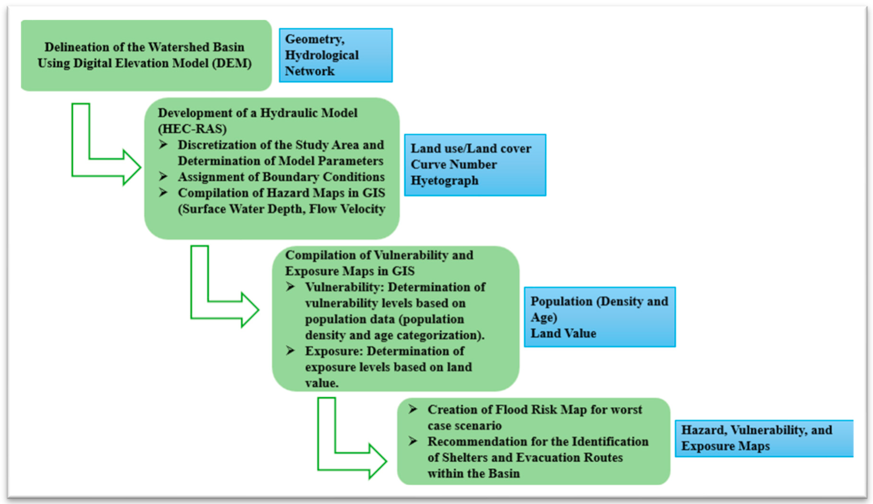
The approach involves hydraulic modeling to create hazard maps for various return periods (50, 100, and 1000 years), along with assessments of flood vulnerability and exposure, to illustrate the flood risk linked to an extreme rainfall event (1000-year return periods) through multicriteria decision analysis. Figure 2 offers a summary of the research methodology used to produce the flood risk assessment. The geometry of the study area was developed in ArcGIS utilizing a Digital Elevation Model (DEM) with a resolution of 5 m. Concurrently, the hydrographic network was incorporated as 2D breaklines to effectively guide and constrain flow paths within the catchment. A numerical grid with variable spatial resolution was established to adequately capture the intricate characteristics of urban and topographic features. The Hyetograph, derived from the IDF curve, was utilized as the hyetograph for the two-dimensional model. Hydrological losses were estimated using the Soil Conservation Service Curve Number (SCS-CN) method, with CN values spatially distributed based on land use and soil properties. Land cover classifications were also employed to assign Manning’s roughness coefficients for floodplain and channel components. The hydraulic model produced outputs including water depth and surface water velocity for each grid cell, which were subsequently used to categorize inundated regions into five hazard classes: very low, low, moderate, high, and very high. Flood vulnerability was evaluated based on population density and age demographic, while flood exposure was assessed, while flood exposure was assessed using land value. A multi-criteria analysis was conducted to merge hazard, vulnerability, and exposure into a comprehensive flood risk map. Lastly, flood risk mitigation strategies were developed based on the results of the risk assessment to target areas identified as having high or very high flooding risk, including recommendations for site-specific interventions and potential protective measures such as safe refuge zones and escape routes for safe evacuation.

4. Preliminary Results and Discussion

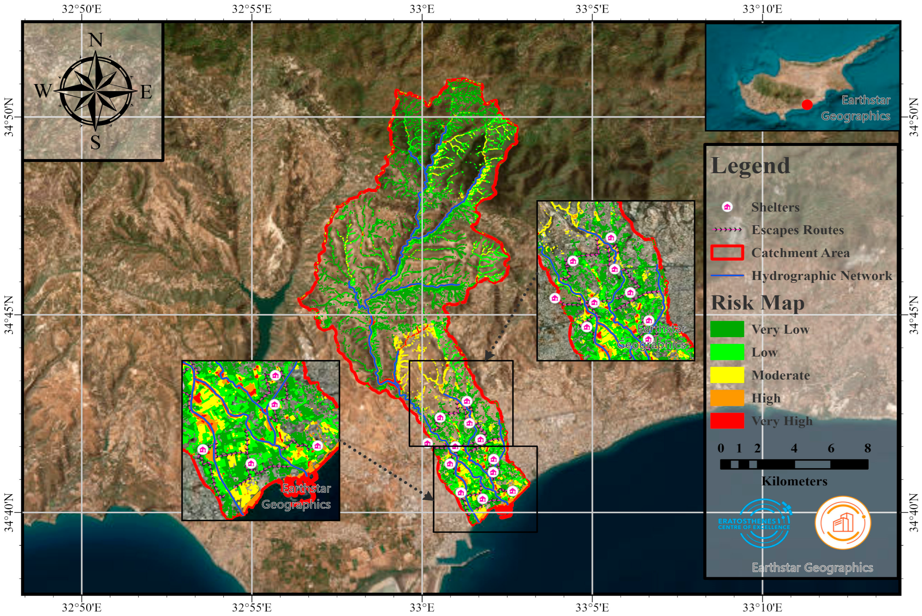
The flood risk evaluation for a 1000-year return period is illustrated for the Garyllis River Basin in Figure 3, which also shows the shelters and suggested escape routes. Areas defined as High- and Very High risk are mostly found in the southern region of the catchment, particularly within the urban coastal area of Limassol. The high-risk zones are exclusively urbanized places that contain essential infrastructure susceptible to severe rainfall. The combination of impervious surface and its closeness to the river network significantly contributes to their heightened flood vulnerability.
In the western and eastern insects, Very High-risk areas are mainly located along main roadways and within residential neighborhoods, underscoring the necessity for specific mitigation strategies. To aid in evacuation planning within these critical regions, proposed emergency shelters and evacuation paths have been outlined.
This study concentrated on evaluating flood hazards, vulnerabilities, and exposure at a granular level within the Garyllis watershed, integrating both physical and socioeconomic information for a comprehensive flood risk assessment. The suggested methodology seeks to propose mitigation strategies in a scientifically reliable and technologically effective manner. Multiple simulations were conducted using various mesh resolutions to confirm the consistency of hydraulic outcomes. The evaluation of vulnerability and exposure faced inherent limitations due to absent data, which were addressed through a specialized multicriteria approach that integrated photo analysis with logical reasoning. Additional difficulties emerged in the identification of safe zones and escape routes. To overcome these challenges, emergency shelters were chosen from enclosed public facilities that could meet basic needs during an emergency. The location of these shelters was planned in order to guarantee sufficient coverage throughout the river basin. In a similar vein, evacuation routes were chosen from less dangerous locations and designed to avoid the river, reducing the chance of flooding and guaranteeing uninterrupted access in the event of an emergency.

5. Conclusions

The paper presents a comprehensive flood risk assessment model designed for the evaluation of the Garyllis River Basin in Cyprus. This model integrates hydraulic simulations, geospatial analysis, and a multicriteria assessment of vulnerability and exposure. By incorporating high-resolution physical and socioeconomic data, the approach facilitated detailed identification of flood-prone zones at the building block level, which is essential for emergency readiness. The method delivered reliable flood risk prediction in spite of obstacles, including model instability and lack of data. The suggested location-specific mitigation strategies, such as shelters and escape routes, demonstrate the study’s applicability in enhancing readiness and resilience in urban drainage regions. In other urbanized river basins, the findings should help local and national authorities connect with EU flood control frameworks and encourage data-driven efforts.

Author Contributions

Conceptualization, J.K., C.F.P. and A.T.; methodology J.K., C.F.P. and A.T.; software, J.K., S.S. and V.P.; validation, J.K. and A.T.; formal analysis, J.K., S.S. and V.P.; investigation, J.K. and C.F.P.; resources, J.K. and C.F.P.; data curation, J.K.; writing—original draft preparation, J.K.; writing—review and editing, J.K., C.F.P., A.T., S.S., V.P., C.K. and C.D.; visualization, J.K.; supervision, D.H.; project administration, D.H.; funding acquisition, D.H. All authors have read and agreed to the published version of the manuscript.

Funding

This work was funded through the EXCELSIOR Teaming project (Grant Agreement No.857510, www.excelsior2020.eu, accessed on 22 January 2025), which has received funding from the European Union’s Horizon 2020 research and innovation programme. Funding was also received from the Government of the Republic of Cyprus through the Directorate General for the European Programmes, Coordination and Development, as well as the Cyprus University of Technology.

Institutional Review Board Statement

Not applicable.

Informed Consent Statement

Not applicable.

Data Availability Statement

Data are contained within the article.

Acknowledgments

The authors acknowledge the ‘EXCELSIOR’: ERATOSTHENES: Excellence Research Centre for Earth Surveillance and Space-Based Monitoring of the Environment H2020 Widespread Teaming project (www.excelsior2020.eu). The ‘EXCELSIOR’ project has received funding from the European Union’s Horizon 2020 research and innovation programme under Grant Agreement No 857510, from the Government of the Republic of Cyprus through the Directorate General forthe European Programmes, Coordination and Development, and from the Cyprus University of Technology.

Conflicts of Interest

The authors declare no conflicts of interest.

References

  1. Ramly, S.; Tahir, W. Application of HEC-GeoHMS and HEC-HMS as Rainfall–Runoff Model for Flood Simulation. In Proceedings of the International Symposium on Flood Research and Management 2015, Shah Alam, Malaysia, 5–7 October 2015. [Google Scholar]
  2. Guha-Sapir, D.; Hoyois, P.; Below, R. Annual Disaster Statistical Review 2015: The Numbers and Trends. Available online: https://www.cred.be/sites/default/files/ADSR_2015.pdf (accessed on 20 June 2025).
  3. Statista. Statista—The Statistics Portal. Available online: https://www.statista.com/ (accessed on 13 June 2025).
  4. Ballester, J.; Quijal-Zamorano, M.; Turrubiates, R.F.M.; Pegenaute, F.; Herrmann, F.R.; Robine, J.M.; Basagaña, X.; Tonne, C.; Antó, J.M.; Achebak, H. Heat-related mortality in Europe during the summer of 2022. Nat. Med. 2023, 29, 1857–1866. [Google Scholar] [CrossRef] [PubMed]
  5. Derdour, A.; Bouanani, A.; Babahamed, K. Modelling rainfall runoff relations using HEC-HMS in a semi-arid region: Case study in Ain Sefra watershed, Ksour Mountains (SW Algeria). J. Water Land Dev. 2018, 36, 45–55. [Google Scholar] [CrossRef]
  6. Abdessamed, D.; Abderrazak, B. Coupling HEC-RAS and HEC-HMS in rainfall–runoff modeling and evaluating floodplain inundation maps in arid environments: Case study of Ain Sefra city, Ksour Mountain. SW of Algeria. Environ. Earth Sci. 2019, 78, 586. [Google Scholar] [CrossRef]
  7. Sett, D.; Trinh, T.P.; Wasim, T.; Ortiz-Vargas, A.; Nguyen, D.G.C.; Büche, K.; Assmann, A.; Nguyen, H.K.L.; Walz, Y.; Souvignet, M.; et al. Advancing understanding of the complex nature of flood risks to inform comprehensive risk management: Findings from an urban region in Central Vietnam. Int. J. Disaster Risk Reduct. 2024, 110, 104652. [Google Scholar] [CrossRef]
  8. Madsen, H.; Lawrence, D.; Lang, M.; Martinkova, M.; Kjeldsen, T. Review of trend analysis and climate change projections of extreme precipitation and floods in Europe. J. Hydrol. 2014, 519, 3634–3650. [Google Scholar] [CrossRef]
  9. Panagiotou, C.F.; Feloni, E.; Aristidou, K.; Eliades, M. Probabilistic Assessment of Flood Susceptibility via a Coparticipative Multicriteria Decision Analysis. Environ. Process. 2025, 12, 1–24. [Google Scholar] [CrossRef]
  10. Panagiotou, C.F. Copula-based assessment of flood susceptibility in the island of Cyprus via stochastic multicriteria decision analysis. Sci. Total Environ. 2025, 979, 179469. [Google Scholar] [CrossRef] [PubMed]
  11. Mojaddadi, H.; Pradhan, B.; Nampak, H.; Ahmad, N.; Ghazali, A.H.B. Ensemble machine-learning-based geospatial approach for flood risk assessment using multi-sensor remote-sensing data and GIS. Geomat. Nat. Hazards Risk 2017, 8, 1080–1102. [Google Scholar] [CrossRef]
  12. Tamiru, H.; Wagari, M. Machine-learning and HEC-RAS integrated models for flood inundation mapping in Baro River Basin, Ethiopia. Model. Earth Syst. Environ. 2021, 8, 2291–2303. [Google Scholar] [CrossRef]
  13. Abu-Abdullah, M.M.; Youssef, A.M.; Maerz, N.H.; Abu-AlFadail, E.; Al-Harbi, H.M.; Al-Saadi, N.S. A Flood Risk Management Program of Wadi Baysh Dam on the Downstream Area: An Integration of Hydrologic and Hydraulic Models, Jizan Region, KSA. Sustainability 2020, 12, 1069. [Google Scholar] [CrossRef]
  14. Kountouri, J.; Panagiotou, C.F.; Tsouni, A.; Sigourou, S.; Pagana, V.; Loulli, E.; Evagorou, E.; Mettas, C.; Kontoes, C.; Hadjimitsis, D. Flood hazard assessment using HEC-RAS mapping in Garyllis river basin, Cyprus. In Proceedings of the Institute of Electrical and Electronics Engineers (IEEE), Athens, Greece, 7–12 July 2024; pp. 3194–3198. [Google Scholar]
  15. Sajjad, A.; Lu, J.; Chen, X.; Yousaf, S.; Mazhar, N.; Shuja, S. Flood hazard assessment in Chenab River basin using hydraulic simulation modeling and remote sensing. Nat. Hazards 2024, 120, 7679–7700. [Google Scholar] [CrossRef]
  16. Wang, X.; Xie, H. A Review on Applications of Remote Sensing and Geographic Information Systems (GIS) in Water Resources and Flood Risk Management. Water 2018, 10, 608. [Google Scholar] [CrossRef]
  17. Natarajan, S.; Radhakrishnan, N. An Integrated Hydrologic and Hydraulic Flood Modeling Study for a Medium-Sized Ungauged Urban Catchment Area: A Case Study of Tiruchirappalli City Using HEC-HMS and HEC-RAS. J. Inst. Eng. (India) Ser. A 2020, 101, 381–398. [Google Scholar] [CrossRef]
  18. Kountouri, J.O.; Sigourou, S.; Pagana, V.; Tsouni, A.; Panagiotou, C.; Mettas, C.; Evagorou, E.; Kontoes, C.; Hadjimitsis, D. Flood hazard assessment using HEC-RAS mapping in Garyllis river basin, Cyprus. In Proceedings of the Tenth International Conference on Remote Sensing and Geoinformation of the Environment (RSCy2024), Paphos, Cyprus, 8–9 April 2024; p. 32. [Google Scholar]
  19. Meresa, H. Modelling of river flow in ungauged catchment using remote sensing data: Application of the empirical (SCS-CN), Artificial Neural Network (ANN) and Hydrological Model (HEC-HMS). Model. Earth Syst. Environ. 2018, 5, 257–273. [Google Scholar] [CrossRef]
  20. Natarajan, S.; Radhakrishnan, N. Simulation of extreme event-based rainfall–runoff process of an urban catchment area using HEC-HMS. Model. Earth Syst. Environ. 2019, 5, 1867–1881. [Google Scholar] [CrossRef]
  21. Awad, A.M. Hydraulic Model Development using HEC-RAS and Determination of Manning Roughness Value for Shatt Al-Rumaith. Muthanna J. Eng. Technol. (MJET) 2016, 4, 9–13. [Google Scholar] [CrossRef]
  22. H. E. C. (HEC) U.S. Army Corps of Engineers. HEC-RAS River Analysis System HEC-RAS User’s Manual. U.S. Army Corps of Engineers, Davis, California, Dec. 2023. Available online: https://www.hec.usace.army.mil/software/hec-ras/documentation.aspx (accessed on 16 June 2025).
  23. Khattak, M.S.; Anwar, F.; Saeed, T.U.; Sharif, M.; Sheraz, K.; Ahmed, A. Floodplain Mapping Using HEC-RAS and ArcGIS: A Case Study of Kabul River. Arab. J. Sci. Eng. 2015, 41, 1375–1390. [Google Scholar] [CrossRef]
  24. Khalil, U.; Khan, N.M. Assessment of Flood Using Geospatial Technique for Indus River Reach: Chashma-Taunsa. Sci. Int. 2015, 27, 1985–1991. [Google Scholar]
  25. Salajegheh, A.; Bakhshaei, M.; Chavoshi, S.; Keshtkar, A.R.; Hajivar, M.N. Floodplain mapping using HEC-RAS and GIS in semi-arid regions of Iran. Desert 2009, 14, 83–93. [Google Scholar]
  26. Islam, M.; Ujiie, K.; Noguchi, R.; Ahamed, T. Flash flood-induced vulnerability and need assessment of wetlands using remote sensing, GIS, and econometric models. Remote Sens. Appl. Soc. Environ. 2022, 25, 100692. [Google Scholar] [CrossRef]
  27. Rahmati, O.; Pourghasemi, H.R.; Melesse, A.M. Application of GIS-based data driven random forest and maximum entropy models for groundwater potential mapping: A case study at Mehran Region, Iran. CATENA 2016, 137, 360–372. [Google Scholar] [CrossRef]
  28. Tsouni, A.; Sigourou, S.; Dimitriadis, P.; Pagana, V.; Iliopoulou, T.; Sargentis, G.-F.; Ioannidis, R.; Chardavellas, E.; Dimitrakopoulou, D.; Mamasis, N.; et al. Multi-parameter flood risk assessment towards efficient flood management in highly dense urban river basins in the Region of Attica, Greece. In Proceedings of the EGU23, the 25th EGU General Assembly, Vienna, Austria, 23–28 April 2023. [Google Scholar]
  29. Tsouni, A.; Sigourou, S.; Pagana, V.; Tsoutsos, M.-C.; Dimitriadis, P.; Sargentis, G.-F.; Iliopoulou, T.; Ioannidis, R.; Dimitrakopoulou, D.; Chardavellas, E.; et al. Multi-Parameter Flood Risk Assessment and Management Planning at High Spatial Resolution in the Region of Attica, Greece. In Proceedings of the IGARSS 2024—2024 IEEE International Geoscience and Remote Sensing Symposium, Athens, Greece, 7–12 July 2024; pp. 1481–1485. [Google Scholar] [CrossRef]
  30. Urban Atlas—European Commission Copernicus Land Monitoring Service (CLMS). European Commission. Available online: https://land.copernicus.eu/en/products/urban-atlas (accessed on 16 June 2025).
  31. Cyprus Civil Defence, CUT, NCSR Demokritos, OC, and CERIDES. National Risk Assessment for the Republic of Cyprus (NRA-CY). 2018. Available online: https://www.moi.gov.cy/MOI/CD/cd.nsf/All/1D4A8C4AE68591AAC2258589003088E7?OpenDocument (accessed on 20 June 2025).
  32. Εν αναμονή της υπερχείλισης του φράγματος Πολεμιδιών. Reporter. Available online: https://reporter.com.cy/article/2019/1/17/212103/kalei-se-deuteres-skepseis-tous-mathetes-o-khampiaoures-enokhlemene-e-psem-me-ta-megala-diagonismata/ (accessed on 20 June 2025).
  33. Υπερχείλισε και ο υδατοφράκτης Πολεμιδιών. Καθημερινή Κύπρου. Available online: https://www.kathimerini.com.cy/gr/kypros/yperxeilise-kai-o-ydatofraktis-polemidiwn (accessed on 20 June 2025).
  34. Copernicus Emergency Management Service—Forest Fire Module (CEMS) European Commission. Available online: https://forest-fire.emergency.copernicus.eu/ (accessed on 11 February 2025).
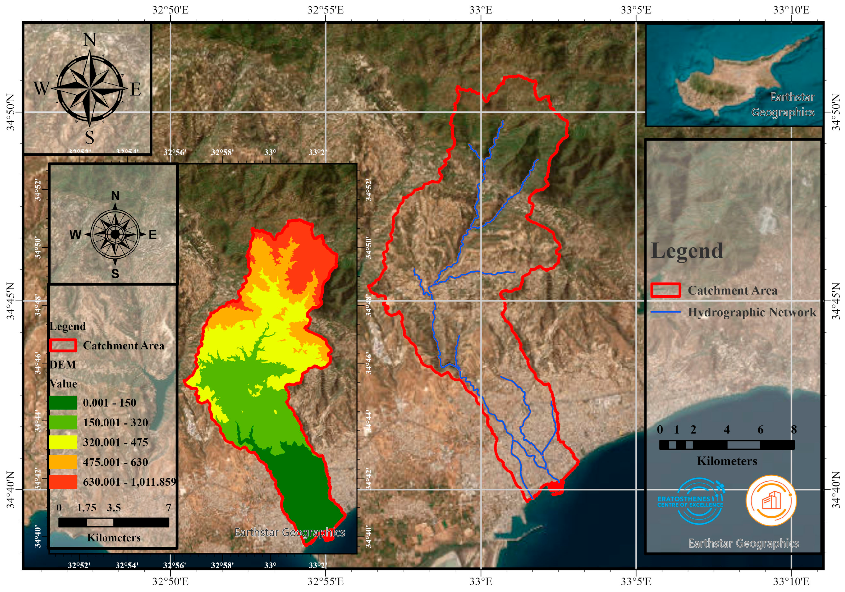
Figure 1. Overview of the Garyllis River Basin showing topography (left) and stream network (right). The catchment area is outlined in red.
Eesp 35 00074 g001
Figure 2. Schematic overview of methodological framework.
Eesp 35 00074 g002
Figure 3. Flood risk evaluation map for the Garyllis River Basin with a 1000-year return period, including designated shelters and escape pathways.
Eesp 35 00074 g003
Table 1. Information and data collected about the Garyllis River Basin.
DataInformationResources
DEM5 m resolutionDepartment of Lands and Surveys, Cyprus
DLS Portal (moi.gov.cy)
Road Network2016Department of Lands and Surveys, Cyprus
DLS Portal (moi.gov.cy)
Rainfall timeseries2011–2023Meteorological Department of Cyprus
Home Page|Department of Meteorology (moa.gov.cy)
Intensity-duration-frequency (IDF) curveKalo-horio stationMeteorological Department of Cyprus
Home Page|Department of Meteorology (moa.gov.cy)
Discharge and water level time series1980–2023Water Development Department of Cyprus
Water Development Department|Home Page (moa.gov.cy)
Hydrological network-Water Development Department of Cyprus
Water Development Department|Home Page (moa.gov.cy)
Land use/land Cover2018Copernicus Land Monitoring Service (CLMS),
Urban Atlas Land Cover/Land Use 2018 (vector), Europe, 6-yearly—Copernicus Land Monitoring Service
Population2011Statistical Service
Στατιστική Υπηρεσία—Aρχική (cystat.gov.cy)
Runoff Curve Number (CN)2009Water Development Department of Cyprus
Water Development Department|Home Page (moa.gov.cy)
Land Value2021Department of Lands and Surveys, Cyprus
DLS Portal (moi.gov.cy)
Disclaimer/Publisher’s Note: The statements, opinions and data contained in all publications are solely those of the individual author(s) and contributor(s) and not of MDPI and/or the editor(s). MDPI and/or the editor(s) disclaim responsibility for any injury to people or property resulting from any ideas, methods, instructions or products referred to in the content.