Proceeding Paper

Greek National Hail Suppression Program: Severe Supercell of CDC +4 Produces Egg-Sized Hail in Thessaly on 7 September 2024 †

1
Hellenic Agricultural Insurance Organization (ELGA), Meteorological Applications Centre, International Airport “Macedonia”, 55103 Thessaloniki, Greece
2
Hellenic National Meteorological Service (HNMS), International Airport “Macedonia”, 55103 Thessaloniki, Greece
*
Author to whom correspondence should be addressed.
Presented at the 17th International Conference on Meteorology, Climatology, and Atmospheric Physics—COMECAP 2025, Nicosia, Cyprus, 29 September–1 October 2025.
Environ. Earth Sci. Proc. 2025, 35(1), 71; https://doi.org/10.3390/eesp2025035071
Published: 15 October 2025

Abstract

On 7 September 2024, a trough, situated over the Black Sea, in combination with a northeasterly outflow of a surface anticyclone over Russia, increased moisture and established an instability environment in Greece. Veering winds with height, in combination with high CAPE values in the middle and upper troposphere, produced a violent supercell. Cloud base updrafts, intense lightning activity and severe precipitation in the form of large hail were the main characteristics of this case. Egg-sized hail was reported, contributing to the highest observed CDC index (+4) in Thessaly. Weather RADAR data were recorded and processed by TITAN, revealing an extensive WER in the RHI.

1. Introduction

Supercells, as originally defined by Browning [1], are among the most organized and severe convective storms, characterized by the presence of one principal deep rotating updraft (mesocyclone), and they belong to the longest-lived types of deep convection [2,3,4]. Very high VIL (Vertically Integrated Liquid-water) values favour very strong updrafts capable of holding and transporting more water into the cold levels of the storm, thus contributing to hail formation. Supercells have been shown to be extremely damaging to agriculture, property and infrastructure in northern and central Greece [5].

2. Data and Methodology

In this study, surface and upper-level weather charts are studied. Remote sensing images are used to cover the study area of central Greece—Thessaly. RADAR (Radio Detection and Ranging) images are obtained from a C-band antenna, which is located at Liopraso (39.67° N, 21.85° E) and operates within the GNHSP (Greek National Hail Suppression Program) conducted by ELGA [6]. Radar data are recorded and processed using the TITAN (Thunderstorm Identification, Tracking, Analysis, and Nowcasting) system [7], including the maximum reflectivity Zmax (dBz) over the −5 °C level, maximum cloud top height (km) and maximum VIL (kg/m2). Lastly, 06:00 UTC sounding data for Thessaloniki were used and analyzed through SHARPpy [8], extracting instability indices and tropopause height.

3. The Classification of Convection by the Greek National Hail Suppression Program

The GNHSP is operated by the Hellenic Agricultural Insurance Organization (ELGA) as an action in the framework of active protection to mitigate the damages caused by hail to agriculture. Hail suppression operations are conducted with airborne technology and silver iodide seeding flares in order to reduce insurance payments due to hail damage [9]. Thunderstorm threat recognition begins with the daily weather forecast issued at 12:00 p.m. local time using surface and upper-level charts at 500 and 850 hPa, upper jet stream analysis at 250/300 hPa and 06:00 UTC Thessaloniki sounding software products. Once all data have been analyzed, the forecaster has a clear idea of the weather expected for the day, so the final step is to determine the CDC (Convective Day Category). The CDC is an index representing a forecasting technique of the maximum level of convective intensity expected, using single numbers corresponding to specific classes of weather activity [10,11]. It essentially gives the potential for hailstorm activity, hail size and thus the likelihood of seeding operations.

4. CDC Extremes in Thessaly

A 21-year-long dataset of the daily values of the observed CDC was constructed during the GNHSP. The relative frequency of days with no deep convection (observed CDC = −3) increased from ~30% before 2010 to ~50% after 2020 (Figure 1a), indicating that convection is going to be less frequent in a changing climate, most likely due to the decreasing cases of CAA (Cold Air Advection). Also, the frequency of cases with weak to moderate convection (−2 ≤ CDC ≤ +1) has also decreased by ~5% (Figure 1b). However, almost no reduction (1%) is observed as far as the frequency of severe cases is concerned (+2 ≤ CDC, Figure 1c), especially of those with CDC = +4 (Figure 1d), which actually tended to increase in the last few years. The developing “gap” between no deep convection and severe convection indicates a future climatic scenario of less convection but with potentially more severe cases, presumably due to the increased moisture content of the atmosphere, as temperature increases. Focusing on the most severe cases, the maximum CDC value (+4) corresponds to severe thunderstorms of golf ball hail size (3.3–5.2 cm in diameter). CDC = +4 was observed in six (6) out of the total of 3763 operational days, three times in 2005, twice in 2021 and once in 2024 (Figure 1d). The topic of this paper is the latter case, 7 September 2024, when an extremely severe supercell produced egg-size hail in Thessaly, Greece.

5. The Case of 7 September 2024

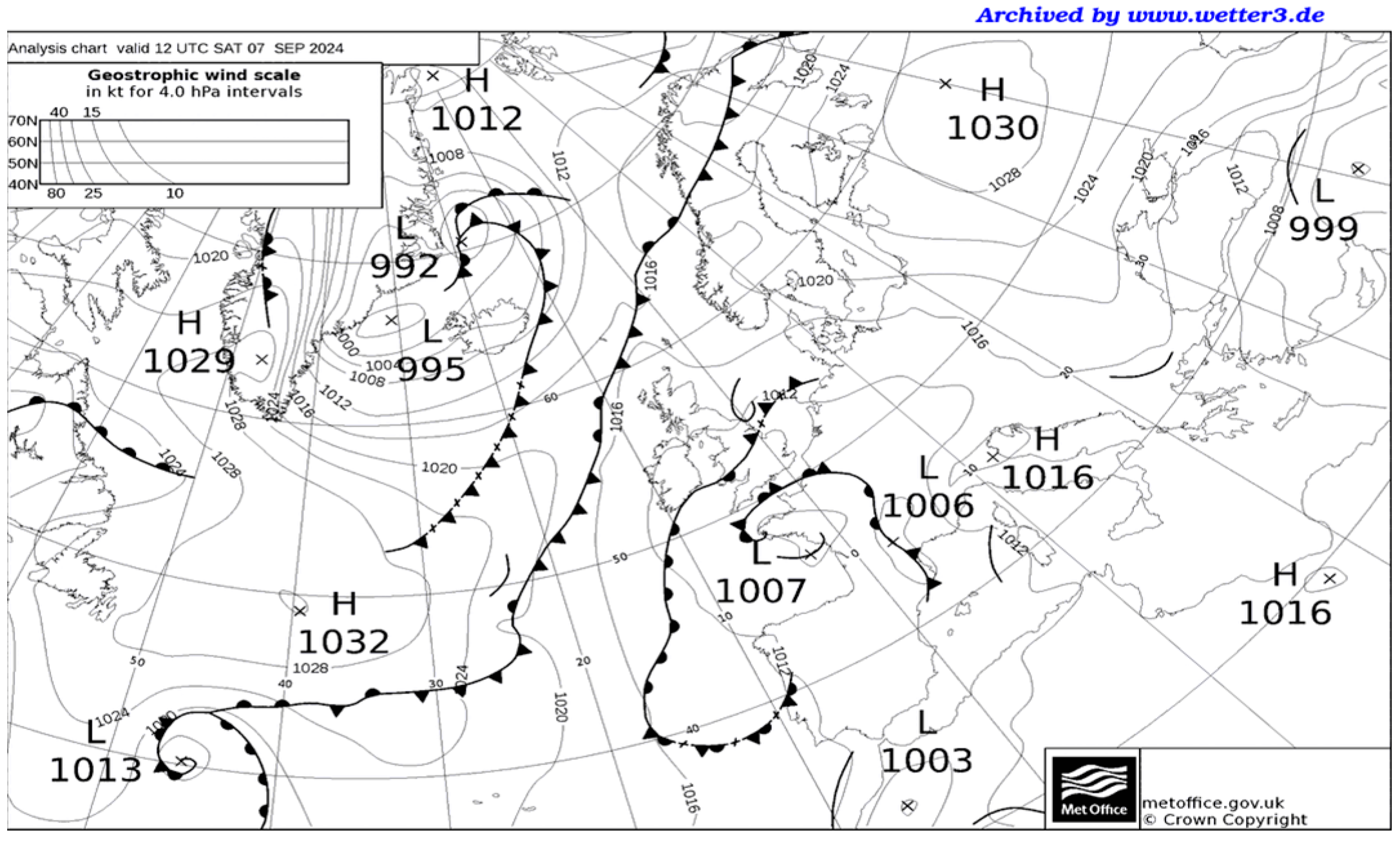
In order to study the synoptic-scale environment, upper- and low-level charts were examined at 00:00 UTC. An upper-level trough (500 hPa) was situated over the Black Sea, accompanied by the −10.7 °C isotherm above the area of interest (Figure 2a). In combination with a northeasterly outflow of a surface anticyclone over Russia, moisture and instability increased in the Greek area, leading to cumulus convection and thundery activity later in the day. At the 850 hPa level (Figure 2b), northern Greece was affected by the 17.5 °C isotherm, located between a thermal ridge extending from northern Africa towards the central Mediterranean and a northeasterly CAA (Cold Air Advection) area, associated with the upper-level trough in the Black Sea. The MSLP (Mean Sea Level Pressure) weather chart at 12:00 UTC (Figure 3) shows a disturbance affecting the areas just off the northern border of Greece (see black line segment), indicating increased cloudiness and risk of precipitation. This disturbance is located along the leading edge of the anticyclonic invasion from the northeast.
The first echo of the supercell under study appeared on the radar screen at 14:32 UTC, northwest of Thessaly. Within about less than an hour, the cell was well organized into a supercell (Figure 4), moving towards the southeast with a forecast wind speed of 43–44 km/h. The distance travelled, during its 5 h long lifetime, was 145 km with a maximum recorded reflectivity of 68 dBz and cloud top of 14 km. The maximum VIL (Vertically Integrated Liquid-water) during the supercell’s life was 187.4 kg/m2. The supercell was observed by Liopraso C-band radar alternatively in the PPI (Plan Position Indicator) and RHI (Range Height Indicator) modes and contained a single extensive WER (Weak Echo Region) and hence an echo overhang [14], indicating nearly vertical updrafts within the echoing region of the storm.
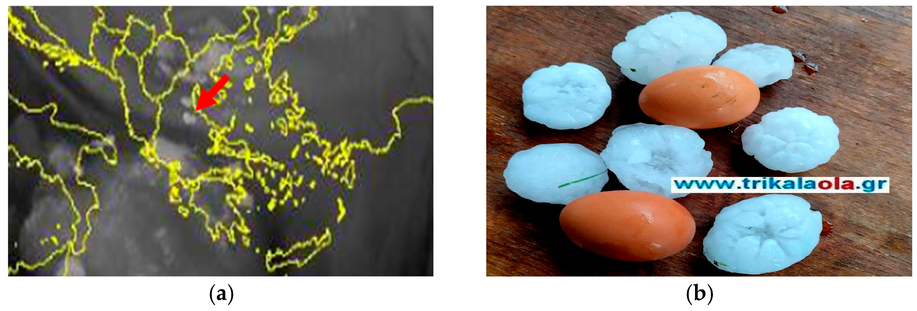
Water vapour satellite imagery (Figure 5a) shows an elongated area of dry stratospheric air, extending from the Adriatic towards the southeast, indicating the axis of a northwesterly jet stream. The position of the jet affects the area of interest in a cyclonic manner, giving rise to an unstable environment that triggers severe supercells, appearing as white spots (see red arrow in Figure 5a), which produced egg-sized hail in Thessaly (Figure 5b). An animation of three hourly visible satellite images, superimposed on 300 hPa vorticity, indeed shows an area of cyclonic vorticity >10−5 s−1, entering Greece at 15:00 UTC, co-located with the cyclonic side of the jet. Moist convection breaks up along the leading edge of the cyclonic vorticity area, presumably associated with positive vorticity advection.
The environmental Thessaloniki sounding for 06:00 UTC on the 7th of September 2024 indicated that considerable instability would develop in Greece with a forecast CAPE value of 1892 J/kg between the LCL (Lifted Condensation Level) at 1805 m and EL (Equilibrium Level) at 12111 m, penetrating the tropopause of 11.9 km. The sky in Thessaly was clear in the morning, and low-level winds were 24–27 km/h (6.7–7.5 m/s). Increased CAPE values forecast potentially severe thunderstorms due to additional thermal convection in the afternoon. Indeed, the daily maximum temperatures exceeded 34.5 °C in Thessaly. Winds veered from westerly at low levels to northwesterly at 600 hPa, indicating WAA (Warm Air Advection) in the intervening tropospheric layer. In combination with a slight temperature decrease above that layer, instability increased from 00:00 UTC to 06:00 UTC. The considerable thermal instability was reflected in the high values of several instability indices (Total Totals: 52; K Index: 36; Showalter Index: −1), while the Lifted Index reached values between −4 ML (Mean Layer) and −6 MU (Most Unstable), indicating moderate to severe instability.

6. Conclusions—Discussion

After studying the relevant upper air and satellite data and up to the degree that the available radar and surface weather data allows, it was concluded that the egg-sized hail accompanying the supercell on the 7th of September 2024 was associated with the following atmospheric–dynamic processes. Slight CAA (WAA) occurred at upper (low–mid) levels, contributing to an increase in thermal instability. At the surface, due to an anticyclonic invasion from the northeast, low-level convergence favoured the triggering of convection, although there is not sufficient surface data to confirm this scenario. Upper-level dynamics were also favourable, as a northwesterly jet streak gave rise to tropospheric ascent, due to vorticity advection along its cyclonic flank. Also, surface characteristics played a major role, as abnormally high daily maximum temperatures acted as a trigger for convection. A 21-year-long observed CDC climatology indicates that such severe cases are likely to occur more frequently in a changing warming climate.

Author Contributions

Conceptualization, M.V.; methodology, M.V.; data curation, M.V. and D.B.; writing—original draft preparation, M.V.; writing—review and editing, M.V. and D.B. All authors have read and agreed to the published version of the manuscript.

Funding

This research received no external funding.

Institutional Review Board Statement

Not applicable.

Informed Consent Statement

Not applicable.

Data Availability Statement

Suggested Data are available upon request from ELGA at https://www.elga.gr.

Acknowledgments

The authors wish to thank ELGA for meteorological and radar data, also Ierotheos Loumpourdis (Software Engineer) and Eleni Theodorou (Undergraduate Physics student) for their valuable help in this manuscript.

Conflicts of Interest

The authors declare no conflict of interest.

References

  1. Browning, K.A. Cellular structure of convective storms. Meteorol. Mag. 1962, 91, 341–350. [Google Scholar]
  2. Browning, K.A. The structure and mechanism of hailstorms. In Hail: A Review of Hail Science and Hail Suppression; American Meteorological Society: Boston, MA, USA, 1977; pp. 1–43. [Google Scholar]
  3. Marwitz, J.D. The structure and motion of severe hailstorms. Part 1: Supercell storms. J. Appl. Meteor. 1972, 11, 166–179. [Google Scholar] [CrossRef]
  4. Bunkers, M.J.; Hjelmfelt, M.R.; Smith, P.L. An observational examination of long-lived supercells. Part I: Characteristics, evolution and demise. Weather Forecast 2006, 21, 673–688. [Google Scholar] [CrossRef]
  5. Christodoulou, M.; Pytharoulis, I.; Karacostas, T. The July 10, 2019 Catastrophic Supercell over Northern Greece Part 1: Observational Analysis. In Proceedings of the 15th Panhellenic Conference of Meteorology, Climatology and Atmospheric Physics, Ioannina, Greece, 26–29 September 2021. [Google Scholar]
  6. Christodoulou, M.; Sioutas, M.; Tegoulias, I. Multiple Supercell Thunderstorms on 11 August 2021 Following an Extreme Heat Wave in Greece: An Unusual Event. In Proceedings of the 16th Panhellenic Conference of Meteorology, Climatology and Atmospheric Physics, Athens, Greece, 25–29 September 2023. [Google Scholar]
  7. Dixon, M.; Wiener, G. TITAN: Thunderstorm Identification, Tracking, Analysis and Nowcasting. A RADAR based Methodology. J. Atmos. Ocean. Technol. 1993, 10, 785–797. [Google Scholar] [CrossRef]
  8. Blumberg, W.G.; Halbert, K.T.; Supinie, T.A.; Marsh, P.T.; Hart, J.A. SHARPpy An open-source sounding analysis toolkit for the atmospheric sciences. Bull. Am. Meteor. Soc. 2017, 98, 1625–1636. [Google Scholar] [CrossRef]
  9. Karacostas, T.; Sioutas, M.; Rudolf, R. The Greek National Hail Suppression Program: Design and conduct of the experiment. In Proceedings of the 5th WMO Scientific Conference on Weather Modification and Applied Cloud Physics, Beijing, China, 8–12 May 1989. [Google Scholar]
  10. Vlachou, M.; Stolaki, S.; Sioutas, M. The Convective Day Category index and related synoptic, radar and hail parameters. In Proceedings of the 15th Panhellenic Conference of Meteorology, Climatology and Atmospheric Physics, Ioannina, Greece, 26–29 September 2021. [Google Scholar]
  11. Strong, G.S.; Wilson, W.D. The synoptic (instability) index: 1978–80 tests and new versions. In Proceedings of the 15th Annual Congress, Canadian Meteorological and Oceanographic Society, Saskatoon, Saskatchewan, 27–29 May 1981. [Google Scholar]
  12. Wetter3.de. Available online: https://www.wetter3.de/archiv_gfs_dt.html (accessed on 8 September 2024).
  13. Wetter3.de. Available online: https://www.wetter3.de/archiv_ukmet_dt.html (accessed on 8 September 2024).
  14. Van Den, S.C.; Cotton, W.R. The Impact of Hail Size on Simulated Supercell Storms. J. Atmos. Sci. 2002, 61, 1596–1609. [Google Scholar] [CrossRef]
  15. Wetterzentrale.de. Available online: https://www.wetterzentrale.de/reanalysis.php (accessed on 8 September 2024).
  16. Trikalaola.gr. Available online: https://www.trikalaola.gr/lachtarisan-sta-trikala-vomvardistikan-perioches-me-chalazi-megethous-avgon-vinteo-foto/ (accessed on 8 September 2024).
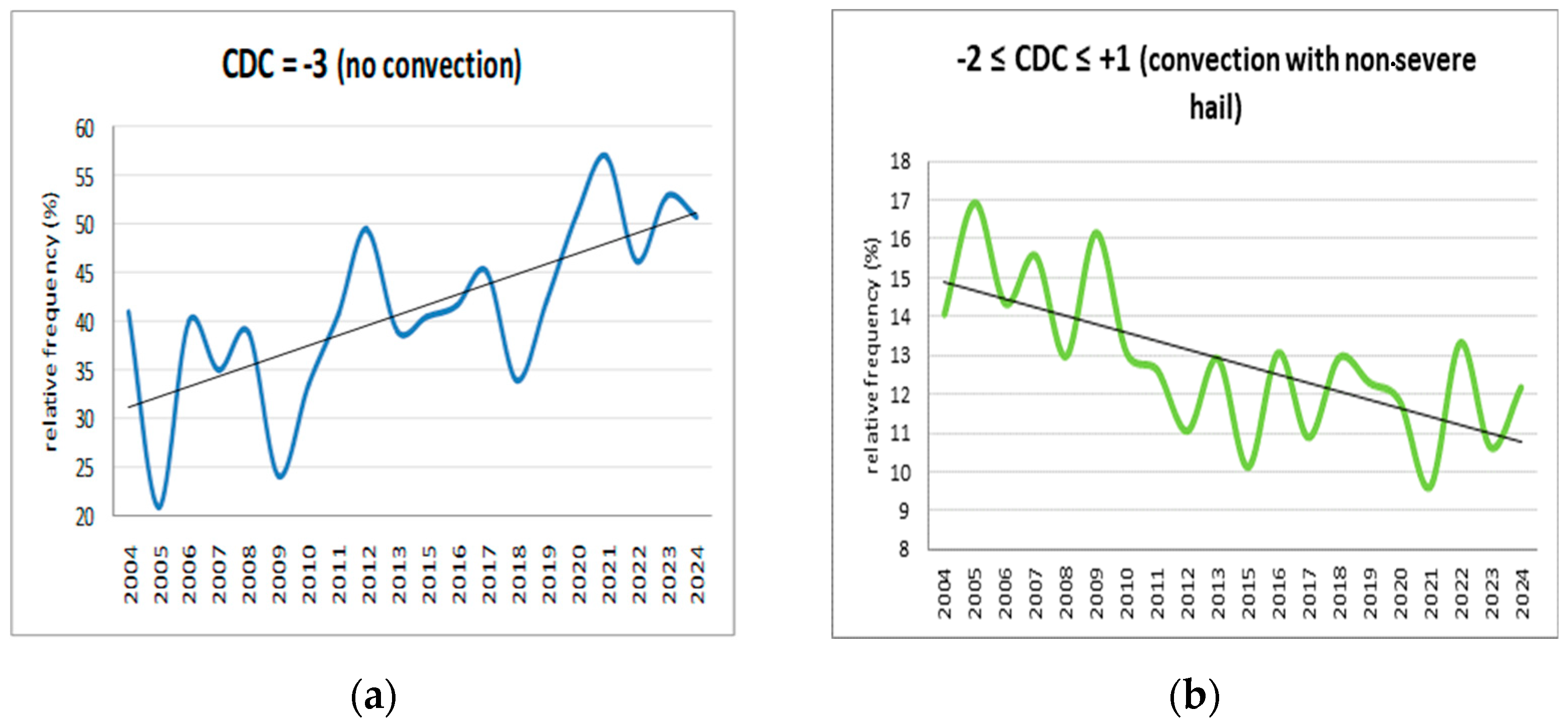
Figure 1. Time series of CDC relative frequency (%): (a) CDC = −3; (b) −2 ≤ CDC ≤ +1; (c) +2 ≤ CDC ≤ +4; (d) CDC = +4.
Eesp 35 00071 g001aEesp 35 00071 g001b
Figure 2. Geopotential height (gpdam) and temperature (colour shading °C) analysis charts on 7 September 2024 at 00:00 UTC: (a) 500 hPa; (b) 850 hPa. Reprinted with permission from ref. [12]. Copyright 2025 Wetter3.de (Rainer Behrendt, Holger Mahlke).
Eesp 35 00071 g002
Figure 3. Analysis surface weather chart at 12:00 UTC. Reprinted with permission from ref. [13]. Copyright 2025 British Crown copyright, Met Office.
Eesp 35 00071 g003
Figure 4. Composite radar reflectivity images and vertical cross-sections at specified times on 7 September 2024: (a) 15:28 UTC; (b) 15:32 UTC.
Eesp 35 00071 g004
Figure 5. (a) Water vapour satellite imagery at 15:00 UTC. Reprinted with permission from ref [15]. Copyright 2025 www.wetterzentrale.de. (b) Egg-sized hail in Thessaly. Reprinted with permission from ref [16]. Copyright 2025 trikalaola.gr.
Eesp 35 00071 g005
Disclaimer/Publisher’s Note: The statements, opinions and data contained in all publications are solely those of the individual author(s) and contributor(s) and not of MDPI and/or the editor(s). MDPI and/or the editor(s) disclaim responsibility for any injury to people or property resulting from any ideas, methods, instructions or products referred to in the content.