1. Introduction
Heat lows (sometimes called thermal troughs) are significant climatic phenomena observed in arid and semiarid regions, particularly in the warmer months, especially at low latitudes where solar radiation is intense [
1,
2]. It lowers pressure up to 10 hPa in a particular region compared to the surrounding area due to intense heating in the atmosphere. In a place where insolation is high, the land surfaces become hot during the daytime, warming the air in the low-level atmosphere. This hot air rises upwards, creating an area of low pressure, i.e., “heat low.” On the other hand, during nighttime cooling, a stable boundary layer is formed where there is an intensified flow of air (low-level jet) and convergence over the heat low [
3,
4]. Heat lows are ubiquitous characteristics of arid areas like northern and south-western Africa, West Pakistan and northern India, the Tibetan Plateau, south-western North America, Saudi Arabia, Spain, and north-western and north-eastern Australia [
1,
5]. They can also be found in semiarid areas like the Iberian Peninsula and West Africa [
2].
The detection of heat lows is essential; one such attempt was made by Lavaysse et al. (2009) [
6] to detect the West African heat low (WAHL). This method involves using Low-Level Atmospheric Thickness (LLAT), derived from the difference in geopotential heights at 700 and 925 hPa, to identify areas of low-level expansion due to increased temperatures. WAHL is defined as an area where LLAT surpasses a threshold set explicitly at the 90th percentile of the cumulative probability distribution function of LLAT over West Africa. Aligned with this, Lavender (2017) added some additional criteria to detect heat low in Australian conditions [
7]. In this study, the identified regions should meet some additional requirements. The mean sea level pressure must minimally deviate from the surrounding grid points, dropping 0.5 hPa below the average of the adjacent 24 grid points to exclude small and weak lows. Furthermore, the 850 hPa vorticity, averaging over eight surrounding grid points, must display a cyclonic pattern. Likewise, an aloft anti-cyclonic circulation is mandated, as indicated by anti-cyclonic 500 hPa vorticity averaged over the surrounding eight grid points.
The Indian heat low is a large-scale atmospheric circulation pattern characterized by low pressure, high temperatures, and a distinct thermal low-pressure cell over the Pakistan and northwestern Indian region [
1,
3]. It plays a crucial role in shaping the South Asian monsoon system, modulating regional weather patterns, and influencing precipitation distribution. The Indian heat low plays an essential role in forming southwesterly monsoon flow and contributes significantly to the precipitation over the western Indian subcontinent [
8]. However, with ongoing climate change, the dynamics of the Indian heat low are expected to undergo notable alterations, leading to potential implications for the environment and human activities.
2. Data
We used outputs from ten Global Climate Models (CCSM4, bcc-csm1-1, CESM1-CAM5, CSIRO-Mk3-6-0, FIO-ESM, HadGEM2-AO, MIROC5, IPSL-CM5A-LR, MRI-CGCM3, and NorESM1-M) obtained from the CMIP5 archive under the medium-to-high emission scenarios (RCP6.0 and RCP8.5). These models were selected to qualitatively assess large-scale changes in surface pressure, temperature, wind fields, and precipitation patterns over the Indian subcontinent. Rather than conducting detailed statistical analyses, this study emphasizes identifying consistent spatial patterns and circulation features projected by the models for the mid and late 21st century. Additionally, ERA5 reanalysis data spanning the 20th century and early 21st century was utilized to understand historical climate features and circulation behavior. The focus remains on detecting robust spatial signals and shifts as represented in both the models and reanalysis data, rather than on quantitative validation.
3. Spatial Variation in the Heat Low in a Changing Climate
Many Coupled Model Intercomparison Project (CMIP) studies have discussed climate change and monsoon pattern variation in the projected climate scenarios. CMIP6’s 16 model comparison research suggests significant enhancement of temperature in the near future over the Indian subcontinent is evident [
9], and relatively higher over the northwestern Indian subcontinent. CMIP6 models show temperature increases of >0.7 °C per decade over northwestern India under the SSP5-8.5 scenario for 2015–2099. This can lead to the expansion of the heat low region over the Indian subcontinent region in the near future.
Scientists are yet to find a clear link between global warming and the strength and interannual variability of the overall Indian monsoon. However, at the regional level, monsoons are found to have positive and negative effects, and there is no trend toward global warming in different subdivisions of India [
10].
The ERA5 reanalysis data reveal an evident broadening of the heat low region over the northern Indian subcontinent in recent decades.
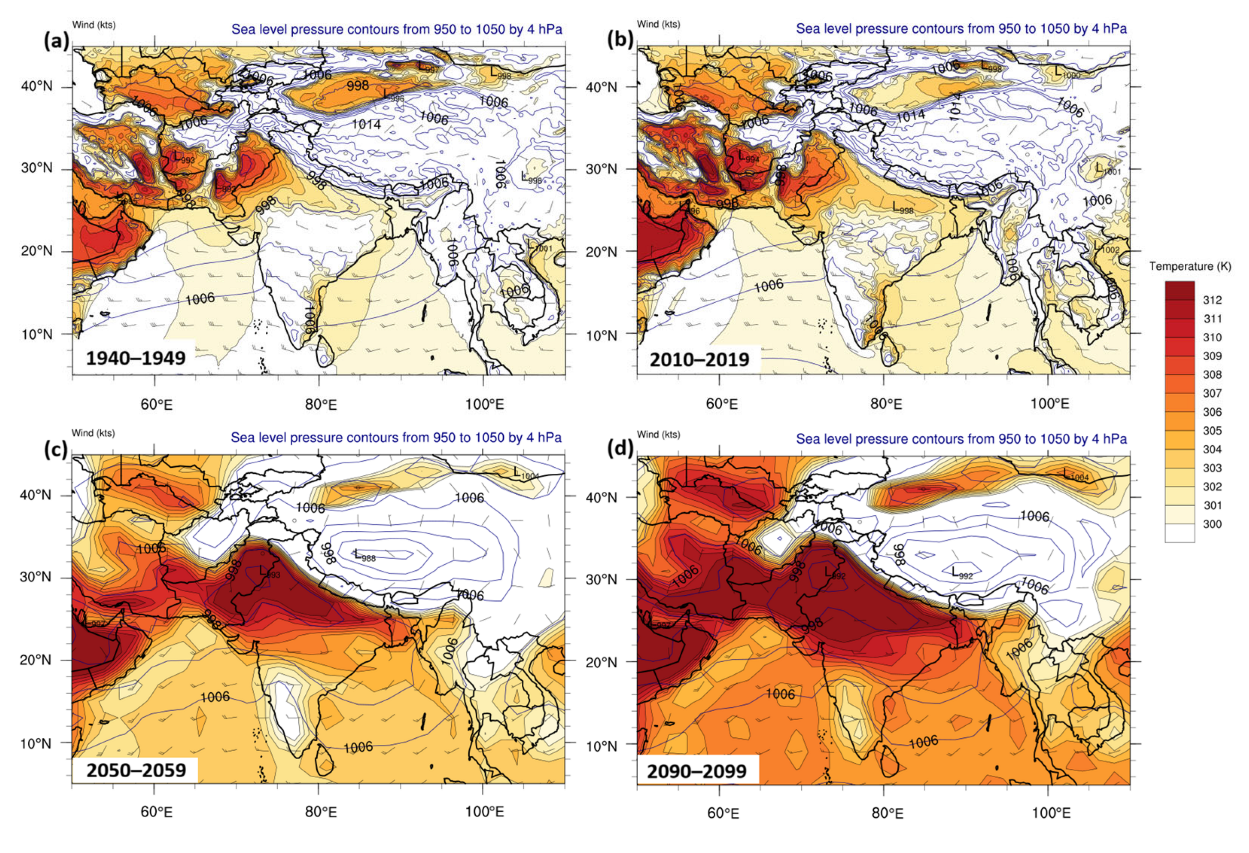
Figure 1a shows the extent of the heat low region during July, the peak summer month, for the decade 1940–1949. At that time, the heat low was primarily concentrated over Pakistan and northwestern India, with a pressure differential of about 10 hPa compared to surrounding regions and temperatures reaching as high as 312 K. Over the next 50 years, this heat low region has expanded significantly eastward, extending into the Indo-Gangetic Plain (IGP) by the current decade (2010–2019), as seen in
Figure 1b. Previous studies using CMIP6 models support this trend, showing consistent temperature increases over northern India across nearly all models, likely driving the observed expansion of the heat low region. Future projections from the Global Climate Models (GCMs) indicate this expansion will continue, with the heat low reaching further into the IGP during the decades 2050–2059 (
Figure 1c) and 2090–2099 (
Figure 1d). This progression could lead to significant alterations in the northwesterly monsoon flow, resulting in substantial changes to precipitation patterns, particularly over Pakistan and northwestern India.
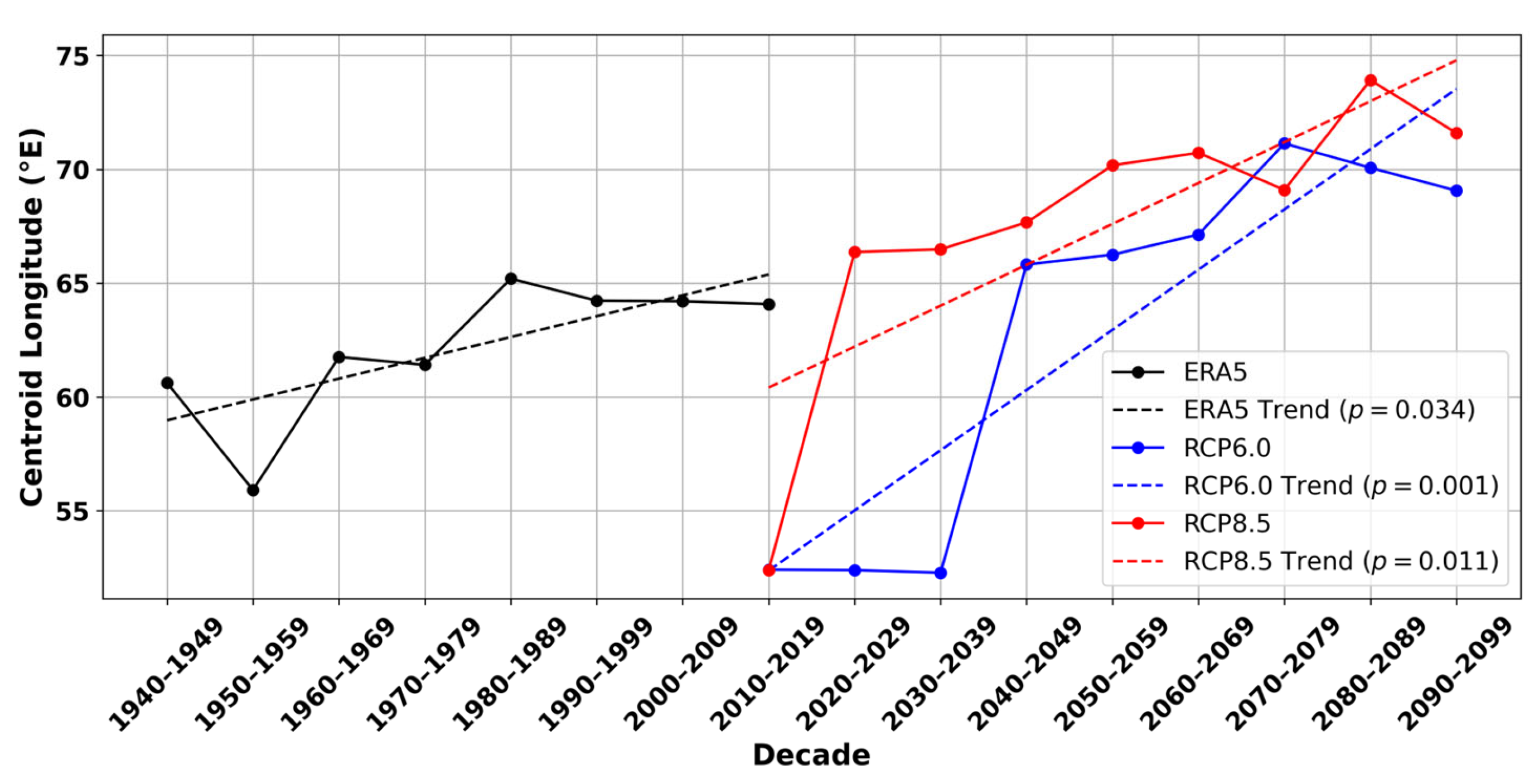
Figure 2, shows the decadal evolution of the heat low region’s centroid longitude over the historical period (1940–2019) using ERA5 reanalysis data, and future projections (2010–2099) under the RCP6.0 and RCP8.5 scenarios. The heat low region is identified based on areas exhibiting a surface pressure change more than 5 hPa relative to the surroundings, combined with persistently high surface temperatures. A clear eastward shift in the centroid is observed across all datasets. ERA5 shows a gradual shift from approximately 60° E to 64° E over 1940–2019, with a statistically significant linear trend (
p = 0.034). This trend continues and intensifies under future warming scenarios. RCP6.0 projects a steady eastward migration, reaching up to 68° E by the end of the century, with a highly significant trend (
p = 0.001). RCP8.5, representing a high-emissions pathway, shows the strongest eastward shift, with the centroid reaching ~74° E by 2090–2099 (
p = 0.011). These results suggest a robust and accelerating eastward displacement of the heat low region in response to anthropogenic warming, which could have important implications for monsoon circulation, low-level winds, and regional rainfall distribution.
4. Changing the Pattern of Precipitation with Heat Low
The observed changes in the summertime heat low have profoundly influenced monsoon flow patterns and precipitation across the Indian subcontinent. Reanalysis data from 1940 to 2020 indicate that the heat low area is expanding and extending into the Indo-Gangetic Plain (IGP) region (
Figure 1 and
Figure 2). This expansion coincides with increased precipitation over the central Himalayan region and parts of the IGP, which has been especially evident in recent decades (
Figure 3). Between 1940 and 2020, precipitation during July notably intensified over the IGP, while western regions of India and Pakistan experienced drier conditions. Projections from the GCM ensemble suggest an eastward shift in precipitation patterns across the Indian subcontinent under the RCP8.5 scenario (
Figure 3c,d), mirroring the projected eastward expansion of the summertime heat low (
Figure 1c,d) over the same period.
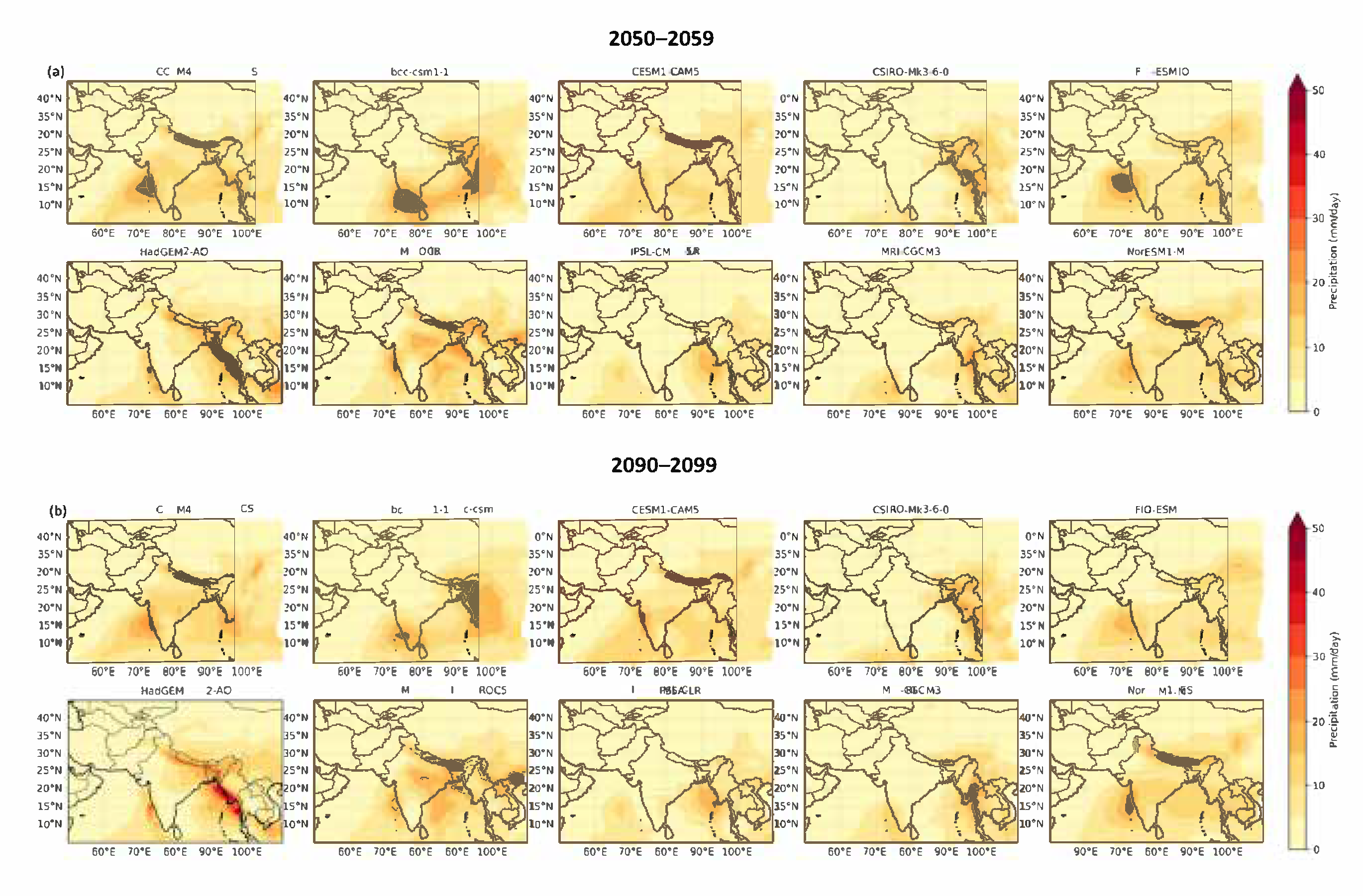
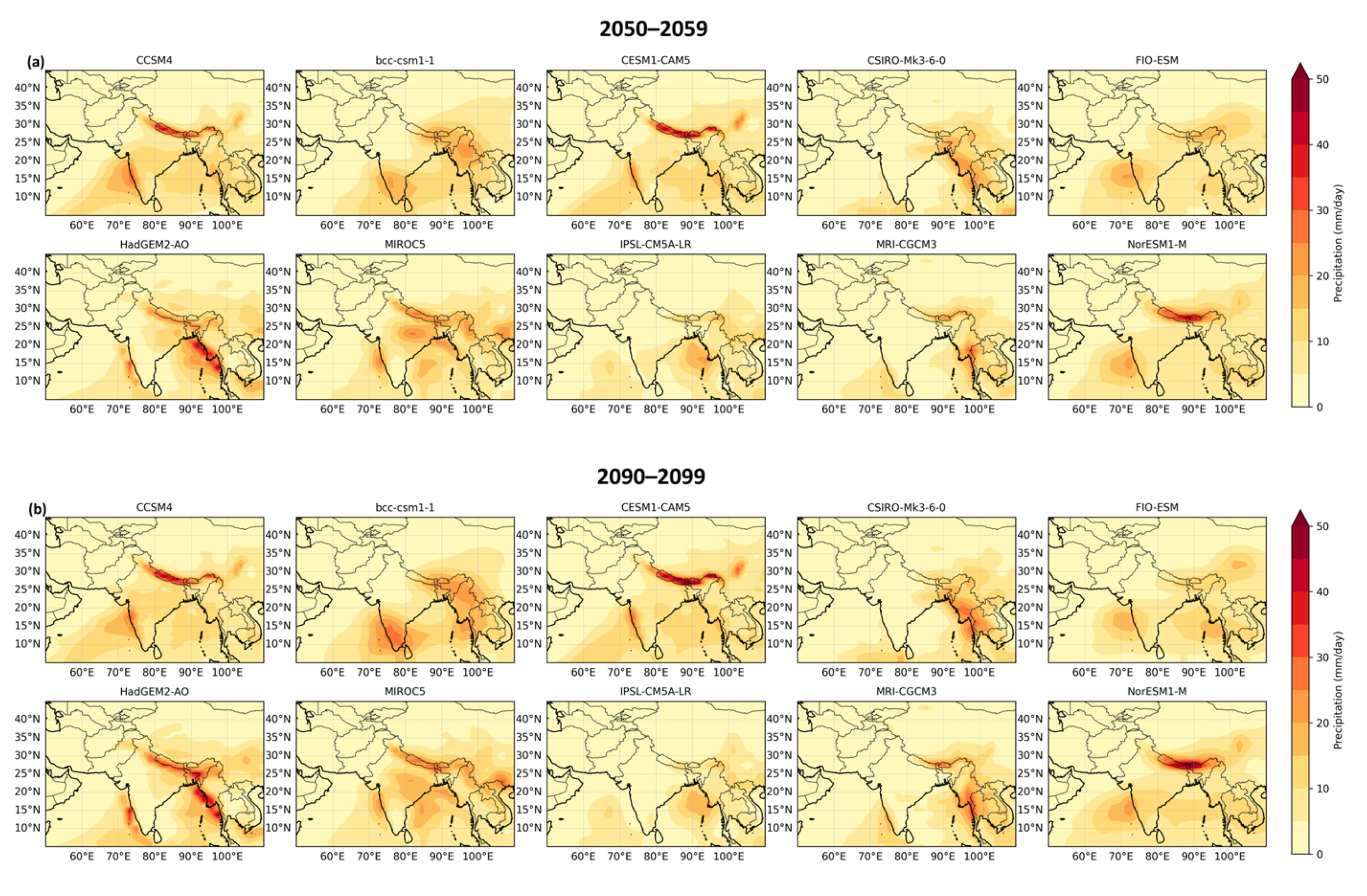
Under the medium emission scenario (RCP6.0), the majority of ensemble members indicate a wetter eastern Indian subcontinent compared to a drier western region, although some differences exist in spatial patterns and precipitation magnitude. However, all ensemble members consistently project reduced precipitation over the western Indian subcontinent (including Pakistan and western India) during the mid- to late 21st century (
Figure 4a,b). Under the high emission scenario (RCP8.5), the projected precipitation patterns broadly agree with those under RCP6.0 for the same period, with some variations both within and between GCMs (
Figure 5a,b). Notably, both medium- and high emission scenarios project a consistent drying trend over the western Indian subcontinent, as highlighted in
Figure 3.
The precipitation trend was analyzed over the heat low region (60°–70° E, 25°–30° N), defined based on the heat low shift shown in
Figure 2. Additionally, eastward changes were examined over the region east of the heat low (80°–90° E, 25°–30° N). The trend analysis for July precipitation reveals that ERA5 data (1940–2020) shows a moderate decreasing trend (−0.076 mm/decade) over the heat low region, which is marginally insignificant (
p ≈ 0.10), suggesting a possible but not statistically robust decline in historical precipitation (
Table 1). Future projections under the RCP6.0 scenario (2010–2100) indicate a very slight and statistically insignificant decline, implying minimal change under medium-emission conditions over the heat low region. In contrast, the RCP8.5 scenario shows a small but statistically significant decreasing trend (−0.005 mm/decade,
p ≈ 0.027), pointing toward a potential weakening of July precipitation under high-emission pathways over the heat low region. The further analysis of July precipitation trends east of the heat low region reveals that ERA5 (1940–2020) exhibits a very weak and statistically insignificant declining trend, suggesting no meaningful long-term change in observed precipitation over the east of the heat low region during this period. In contrast, projections from climate models under RCP6.0 and RCP8.5 scenarios (2010–2100) indicate statistically significant increases in precipitation. Specifically, RCP6.0 shows a moderate increasing trend, while RCP8.5 projects a stronger and highly significant increase, highlighting the potential for enhanced monsoonal rainfall under high-emission pathways in the east of the heat low region.
5. Conclusions
As global temperatures rise, the Northern Indian Subcontinent is projected to experience amplified warming, exacerbating the intensity and duration of the heat low (
Figure 1 and
Figure 2). These changes can lead to increased heat waves, heat stress, and adverse impacts on public health, agriculture, and water resources. Furthermore, alterations in the strength and position of the heat low may disrupt the monsoon circulation, cause irregular rainfall patterns, and potentially impact regional food security. The changing climate also influences the interaction between the Indian heat low and other large-scale atmospheric systems, such as the Western Disturbances and the El Niño-Southern Oscillation. These interactions can influence extreme weather events, including heavy rainfall, droughts, and tropical cyclones, which have profound socio-economic consequences for the region.
To address the challenges posed by the changing dynamics of the Indian heat low, it is crucial to improve our understanding of the underlying mechanisms and their interactions with global climate patterns. Enhanced climate modeling and observational systems can provide valuable insights into the future behavior of the heat low and its impacts on the Northern Indian Subcontinent. Mitigation and adaptation strategies should focus on reducing greenhouse gas emissions, promoting sustainable land and water management practices, and enhancing early warning systems to cope with the changing climate and associated risks. Integrated approaches that consider both natural and human systems are essential to build resilience and ensure the well-being of communities in the face of a changing climate and the implications of the evolving Indian Heat low.
In conclusion, the summertime heat low over the Northern Indian subcontinent is critical in the regional climate system, monsoon dynamics, and various socio-economic sectors. As the climate continues to change, understanding and managing the implications of the changing Indian heat low becomes imperative for sustainable development and effective regional climate adaptation strategies.


