
Static Terrestrial Laser Scanning (TLS) for Heritage Building Information Modeling (HBIM): A Systematic Review


Abstract
:1. Introduction
- BIM: Building Information Modeling;
- CP: Control Point;
- DSLR: Digital Single Lens Reflex;
- GCP: Ground Control Point;
- GPS: Global Positioning System;
- HBIM: Heritage Building Information Modeling;
- LiDAR: Light Detection and Ranging;
- LOD: Level of Development;
- MLS: Mobile Laser Scanning;
- MMS: Mobile Mapping System;
- PRISMA: Preferred Reporting Items for Systematic Review and Meta-Analysis;
- RC: Reality Capture;
- SfM: Structure from Motion;
- TLS: Terrestrial Laser Scanning;
- TS: Total Station;
- UAV: Unmanned Aerial Vehicle;
- VR: Virtual Reality;
- WOS: Web of Science.
2. Research Design and Methodology
2.1. Search Method and Information Sources
2.2. Search Process
2.3. Search Results
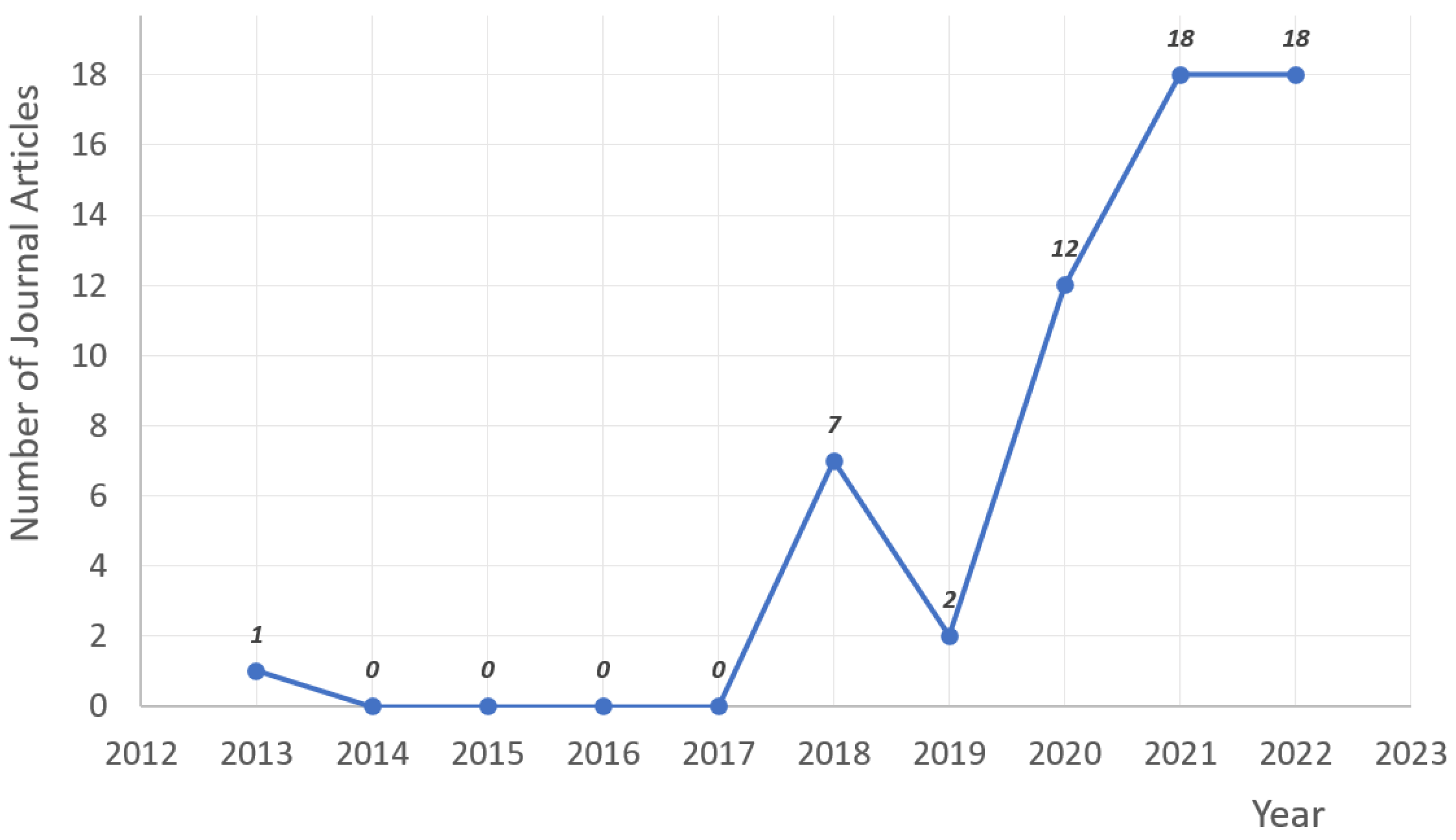
2.3.1. Evolution of Publications per Year
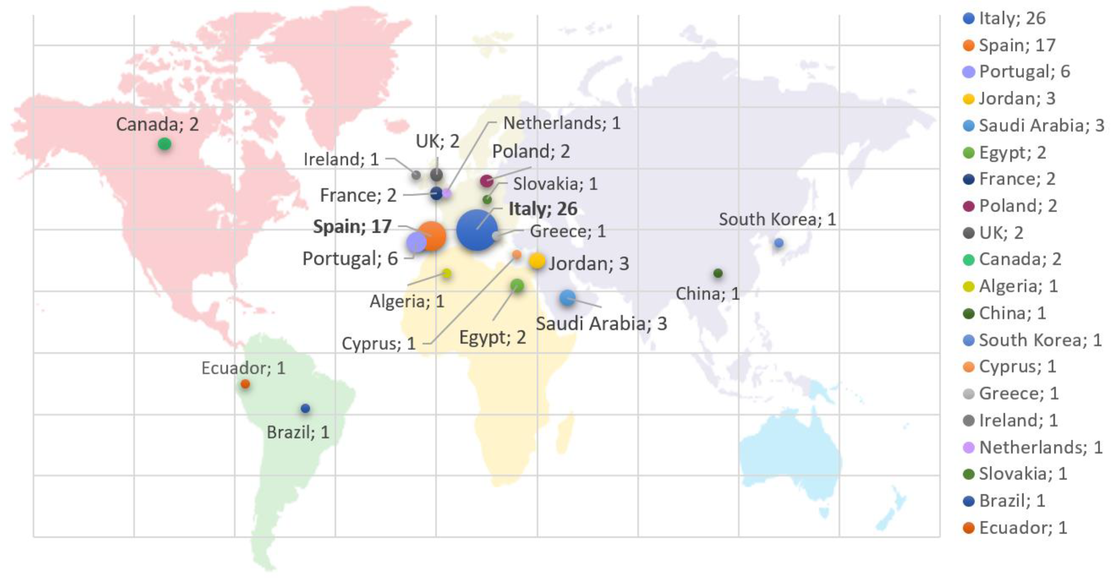
2.3.2. Origin Countries of Authors
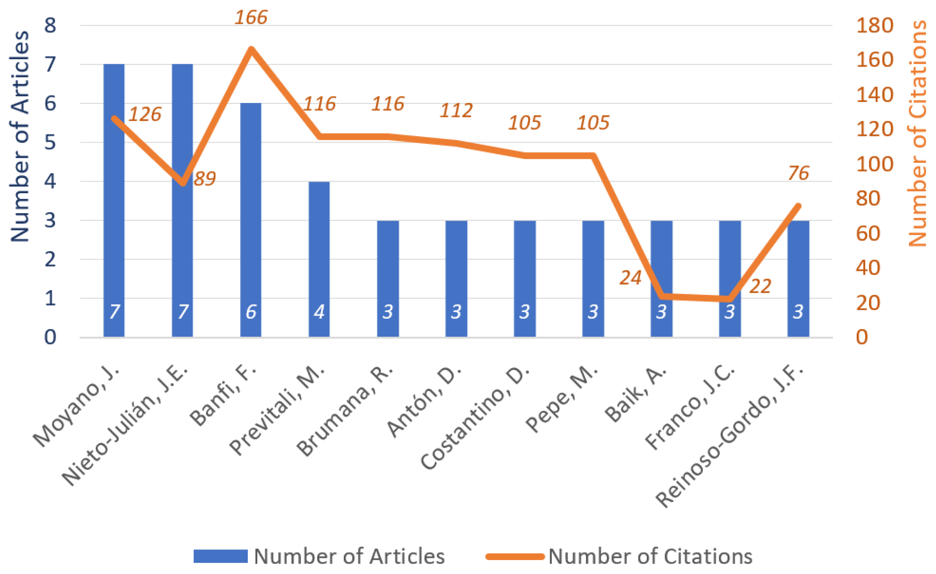
2.3.3. Most Active Authors
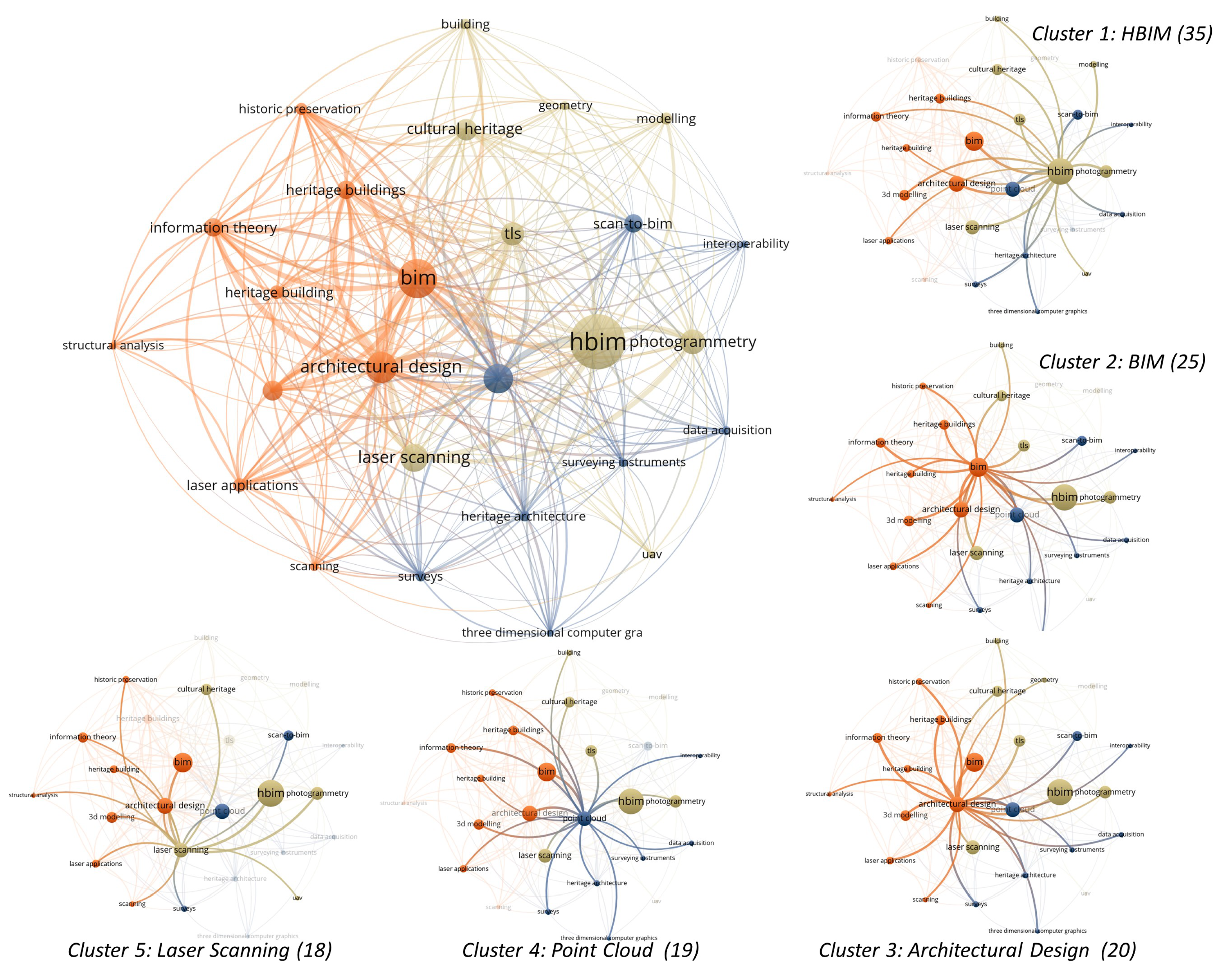
2.3.4. Keywords Collaboration-Network
2.3.5. Publications by Study Type
3. TLS Survey for HBIM
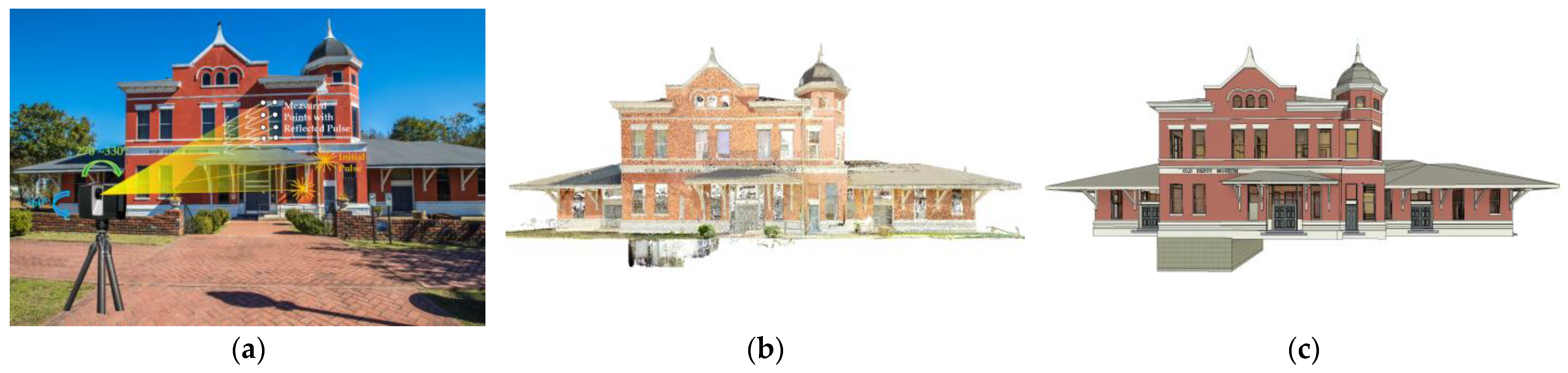
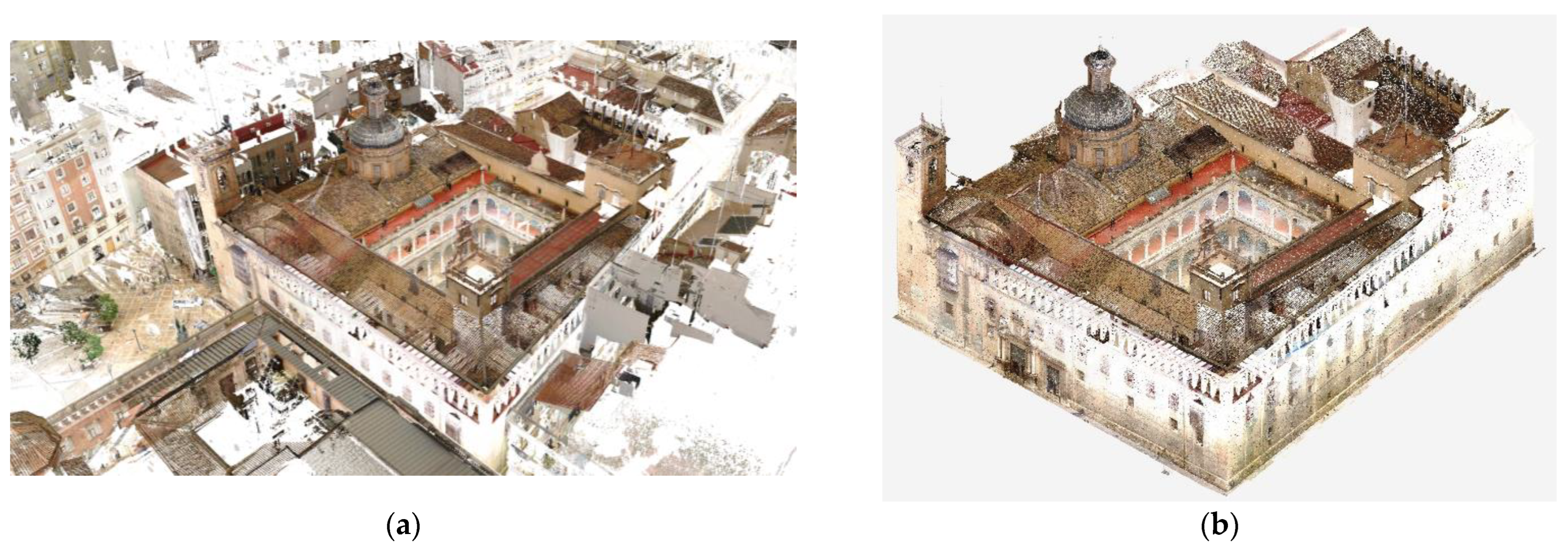
3.1. Terrestrial Laser Scanning (TLS) for Data Acquisition for HBIM
3.2. Challenges and Limitations of TLS for HBIM
- Data acquisition time: TLS involves capturing a large number of high-density point clouds from various viewpoints to cover the entire area of interest. This process can take a considerable amount of time, especially for large or complex areas where multiple scanning setups are needed;
- Environmental conditions: Environmental conditions can also impact the survey time. Factors such as weather conditions, sunlight, and shadowing can affect the quality of the data collected, which may require additional scanning time to compensate;
- Data processing time: Once the data is acquired, it needs to be processed to generate a usable point cloud. Large datasets with high point densities can take a long time to process, which can contribute to the overall time required for the survey.
3.3. Planning for the TLS Survey
- The expectation of the data to be collected, e.g., accuracy and density of the point cloud, coverage of the structure [67];
- The characteristics of the heritage to be captured, e.g., location, size, accessibility, complexity, occlusions and inaccessible areas; and the time constraints of the survey [68];
- The atmosphere during the TLS survey, e.g., weather conditions such as humidity, temperature, and visibility [69];
- The specification and limitation of the TLS equipment, i.e., scanning range, speed, scan-station setting up requirements, and the requirements for scanning targets [51].
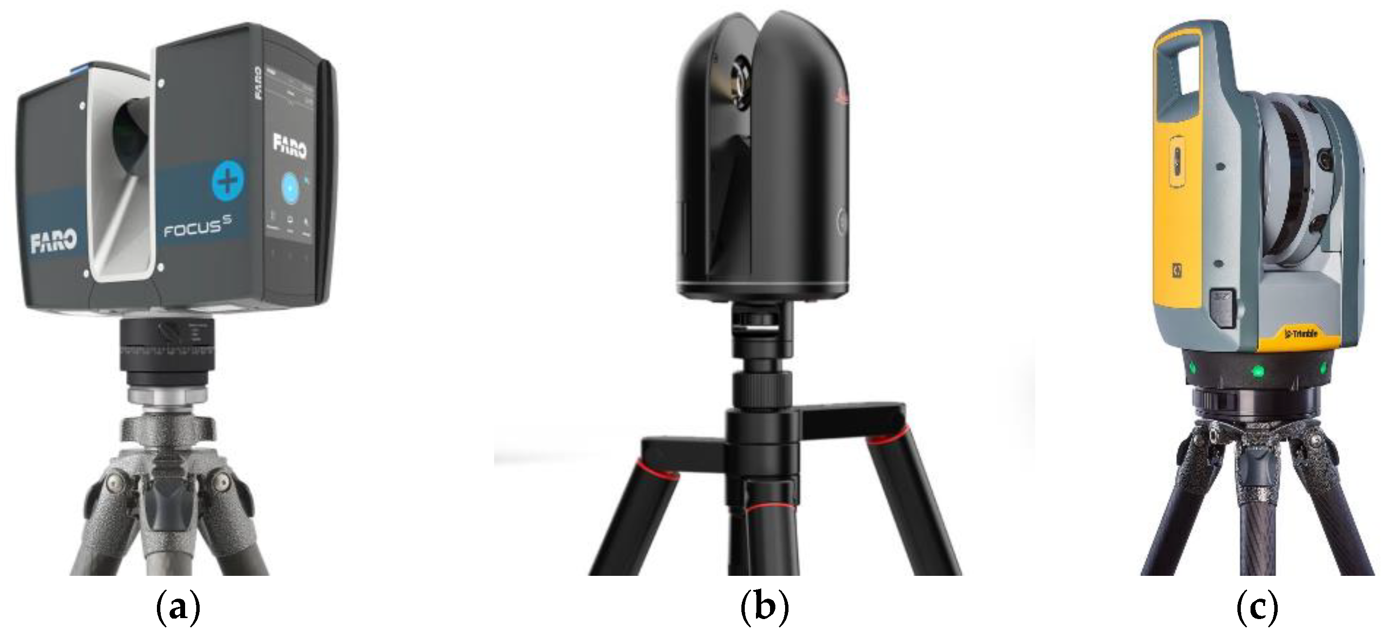
3.4. Static TLS Devices
3.5. TLS Survey
3.6. Other RC Technologies Assisting TLS for Data Acquisition
3.6.1. SfM/Photogrammetry
3.6.2. Mobile Handheld Scanners
3.6.3. TS and GPS
4. TLS Scan Data Processing
4.1. Scan Processing Software
4.2. TLS Scan Processing Workflow
4.3. Integration of Multiple RC Point Clouds
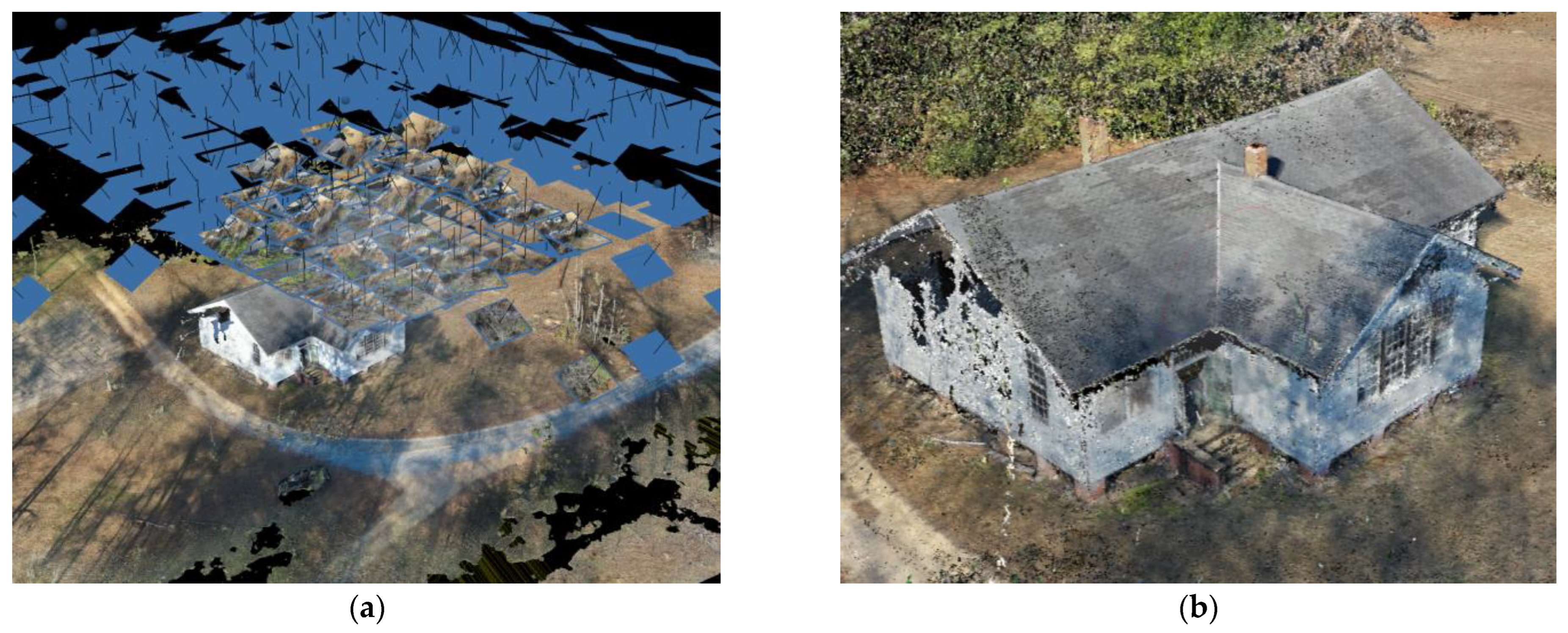
4.4. Evaluation of Point Cloud Data
5. Discussion
6. Conclusions, Knowledge Gaps, and Research Limitations
- The lack of guidelines for data acquisition for HBIM programs is a significant challenge that must be addressed. The lack of standardized methodologies and protocols for the integration of TLS data into HBIM models hinders the adoption and implementation of these technologies in the cultural heritage domain [86]. Practitioners often have to create their own methods to capture the existing condition of the built heritage based on the project’s characteristics, available resources, and their own experiences and knowledge. A clear guideline covering the planning, implementation, and data processing and transferring can help simplify the process and lower the cost, and it can also help practitioners establish their data acquisition methodology in line with the Level of Development (LOD) of the proposed HBIM model;
- The development of HBIM from TLS point cloud data mainly remains a manual process that requires significant effort. Efficient and accurate processing and integration of large and complex datasets derived from TLS and other sources remain a challenge [85]. Developing automated and semi-automated techniques for data processing, segmentation, and feature extraction can significantly reduce the time and resources required for capturing data on the existing condition of built heritage and creating the models, and contribute to streamlining the overall HBIM development process;
- The under-utilized capacity of TLS for long-term monitoring and change detection: While TLS has been widely used for the initial documentation and 3D modeling of heritage sites, its potential for long-term monitoring, change detection, and condition assessment remains underexplored [60,82]. Future research can focus on developing methodologies and tools for the systematic use of TLS data in monitoring and assessing the conservation status of heritage structures over time.
Author Contributions
Funding
Institutional Review Board Statement
Informed Consent Statement
Data Availability Statement
Conflicts of Interest
References
- Adami, A.; Bruno, N.; Rosignoli, O.; Scala, B. HBIM for Planned Conservation: A New Approach to Information Management. In Proceedings of the CHNT23, Vienna, Austria, 12–15 November 2018; p. 41. [Google Scholar]
- Angulo-Fornos, R.; Castellano-Román, M. HBIM as Support of Preventive Conservation Actions in Heritage Architecture. Experience of the Renaissance Quadrant Façade of the Cathedral of Seville. Appl. Sci. 2020, 10, 2428. [Google Scholar] [CrossRef] [Green Version]
- Jordan-Palomar, I.; Tzortzopoulos, P.; García-Valldecabres, J.; Pellicer, E. Protocol to Manage Heritage-Building Interventions Using Heritage Building Information Modelling (HBIM). Sustainability 2018, 10, 908. [Google Scholar] [CrossRef] [Green Version]
- Laefer, D.F.; Truong-Hong, L. Toward automatic generation of 3D steel structures for building information modelling. Autom. Constr. 2017, 74, 66–77. [Google Scholar] [CrossRef]
- Murphy, M.; McGovern, E.; Pavia, S. Historic Building Information Modelling–Adding intelligence to laser and image based surveys of European classical architecture. ISPRS J. Photogramm. Remote Sens. 2013, 76, 89–102. [Google Scholar] [CrossRef]
- Reinoso-Gordo, J.F.; Rodríguez-Moreno, C.; Gómez-Blanco, A.J.; León-Robles, C. Cultural Heritage Conservation and Sustainability Based on Surveying and Modeling: The Case of the 14th Century Building Corral del Carbón (Granada, Spain). Sustainability 2018, 10, 1370. [Google Scholar] [CrossRef] [Green Version]
- Yang, X.; Grussenmeyer, P.; Koehl, M.; Macher, H.; Murtiyoso, A.; Landes, T. Review of built heritage modelling: Integration of HBIM and other information techniques. J. Cult. Herit. 2020, 46, 350–360. [Google Scholar] [CrossRef]
- Bagnolo, V.; Argiolas, R.; Cuccu, A. HBIM for Archaeological Sites: From SfM Based Survey to Algorithmic Modeling. ISPRS-Int. Arch. Photogramm. Remote Sens. Spat. Inf. Sci. 2019, XLII-2/W9, 57–63. [Google Scholar] [CrossRef] [Green Version]
- Fobiri, G. A Scientometric Review of Reality Capture Applications in The Built Environment. In Proceedings of the 21st International Conference on Construction Application of Virtual Reality, Middlesbrough, UK, 12 December 2021. [Google Scholar]
- León-Robles, C.A.; Reinoso-Gordo, J.F.; González-Quiñones, J.J. Heritage Building Information Modeling (H-BIM) Applied to A Stone Bridge. ISPRS Int. J. Geo-Inf. 2019, 8, 121. [Google Scholar] [CrossRef] [Green Version]
- Logothetis, S.; Delinasiou, A.; Stylianidis, E. Building Information Modelling for Cultural Heritage: A Review. In Proceedings of the ISPRS Annals of the Photogrammetry, Remote Sensing and Spatial Information Sciences; Copernicus GmbH, Taipei, Taiwan, 11 August 2015; Volume II-5-W3, pp. 177–183. [Google Scholar]
- Alshawabkeh, Y.; Baik, A.; Miky, Y. Integration of Laser Scanner and Photogrammetry for Heritage BIM Enhancement. ISPRS Int. J. Geo-Inf. 2021, 10, 316. [Google Scholar] [CrossRef]
- Dore, C.; Murphy, M. Current State Of The Art Historic Building Information Modelling. ISPRS-Int. Arch. Photogramm. Remote Sens. Spat. Inf. Sci. 2017, XLII-2/W5, 185–192. [Google Scholar] [CrossRef] [Green Version]
- Marzouk, M. Using 3D Laser Scanning to Analyze Heritage Structures: The Case Study of Egyptian Palace. J. Civ. Eng. Manag. 2020, 26, 53–65. [Google Scholar] [CrossRef]
- Van Valkenburgh, P.; Cushman, K.C.; Castillo Butters, L.J.; Rojas Vega, C.; Roberts, C.B.; Kepler, C.; Kellner, J. Lasers without Lost Cities: Using Drone Lidar to Capture Architectural Complexity at Kuelap, Amazonas, Peru. J. Field Archaeol. 2020, 45, S75–S88. [Google Scholar] [CrossRef] [Green Version]
- Baik, A.; Alitany, A.; Boehm, J.; Robson, S. Jeddah Historical Building Information Modelling “JHBIM”–Object Library. Available online: http://dx.doi.org/10.5194/isprsannals-II-5-41-2014 (accessed on 11 December 2021).
- Berrett, B.E.; Vernon, C.A.; Beckstrand, H.; Pollei, M.; Markert, K.; Franke, K.W.; Hedengren, J.D. Large-Scale Reality Modeling of a University Campus Using Combined Uav and Terrestrial Photogrammetry for Historical Preservation and Practical Use. Drones 2021, 5, 136. [Google Scholar] [CrossRef]
- Carvajal-Ramirez, F.; Martinez-Carridondo, P.; Yero-Paneque, L.; Aguera-Vega, F. UAV Photogrammetry and HBIM for the Virtual Reconstruction of Heritage. In Proceedings of the 27th CIPA International Symposium-Documenting the Past for a Better Future, 1–5 September 2019; International Society for Photogrammetry and Remote Sensing: Avila, Spain, 2019; Volume 42, pp. 271–278. [Google Scholar]
- Ibrahim, A.; Golparvar-Fard, M.; El-Rayes, K. Multiobjective Optimization of Reality Capture Plans for Computer Vision–Driven Construction Monitoring with Camera-Equipped UAVs. J. Comput. Civ. Eng. 2022, 36, 04022018. [Google Scholar] [CrossRef]
- Martínez-Carricondo, P.; Carvajal-Ramírez, F.; Yero-Paneque, L.; Agüera-Vega, F. Combination of nadiral and oblique UAV photogrammetry and HBIM for the virtual reconstruction of cultural heritage. Case study of Cortijo del Fraile in Níjar, Almería (Spain). Build. Res. Inf. 2020, 48, 140–159. [Google Scholar] [CrossRef]
- Banfi, F.; Previtali, M.; Stanga, C.; Brumana, R. A Layered-Web Interface Based on HBIM and 360° Panoramas for Historical, Material and Geometric Analysis. ISPRS-Int. Arch. Photogramm. Remote Sens. Spat. Inf. Sci. 2019, XLII-2/W9, 73–80. [Google Scholar] [CrossRef] [Green Version]
- Barrile, V.; Bernardo, E.; Bilotta, G. An Experimental HBIM Processing: Innovative Tool for 3D Model Reconstruction of Morpho-Typological Phases for the Cultural Heritage. Remote Sens. 2022, 14, 1288. [Google Scholar] [CrossRef]
- Bastem, S.S.; Cekmis, A. Development of historic building information modelling: A systematic literature review. Build. Res. Inf. 2022, 50, 527–558. [Google Scholar] [CrossRef]
- UNAVCO. Available online: https://www.unavco.org/help/glossary/glossary.html#lidar (accessed on 7 January 2022).
- Colombo, L.; Marana, B. Terrestrial Laser Scanning. Available online: https://www.gim-international.com/content/article/terrestrial-laser-scanning-2 (accessed on 7 January 2022).
- Del Duca, G.; Machado, C. Assessing the Quality of the Leica BLK2GO Mobile Laser Scanner versus the Focus 3D S120 Static Terrestrial Laser Scanner for a Preliminary Study of Garden Digital Surveying. Heritage 2023, 6, 1007–1027. [Google Scholar] [CrossRef]
- Gollob, C.; Ritter, T.; Nothdurft, A. Comparison of 3D Point Clouds Obtained by Terrestrial Laser Scanning and Personal Laser Scanning on Forest Inventory Sample Plots. Data 2020, 5, 103. [Google Scholar] [CrossRef]
- Bauwens, S.; Bartholomeus, H.; Calders, K.; Lejeune, P. Forest Inventory with Terrestrial LiDAR: A Comparison of Static and Hand-Held Mobile Laser Scanning. Forests 2016, 7, 127. [Google Scholar] [CrossRef] [Green Version]
- Williams, R.D.; Lamy, M.; Maniatis, G.; Stott, E. Three-dimensional reconstruction of fluvial surface sedimentology and topography using personal mobile laser scanning. Earth Surf. Process. Landf. 2019, 45, 251–261. [Google Scholar] [CrossRef]
- Che, E.; Jung, J.; Olsen, M.J. Object Recognition, Segmentation, and Classification of Mobile Laser Scanning Point Clouds: A State of the Art Review. Sensors 2019, 19, 810. [Google Scholar] [CrossRef] [PubMed] [Green Version]
- Kukko, A.; Kaartinen, H.; Hyyppä, J.; Chen, Y. Multiplatform Mobile Laser Scanning: Usability and Performance. Sensors 2012, 12, 11712–11733. [Google Scholar] [CrossRef] [Green Version]
- Barnhart, T.B.; Crosby, B.T. Comparing Two Methods of Surface Change Detection on an Evolving Thermokarst Using High-Temporal-Frequency Terrestrial Laser Scanning, Selawik River, Alaska. Remote Sens. 2013, 5, 2813–2837. [Google Scholar] [CrossRef] [Green Version]
- Hohenthal, J.; Alho, P.; Hyyppä, J.; Hyyppä, H. Laser scanning applications in fluvial studies. Prog. Phys. Geogr. Earth Environ. 2011, 35, 782–809. [Google Scholar] [CrossRef]
- Di Stefano, F.; Chiappini, S.; Gorreja, A.; Balestra, M.; Pierdicca, R. Mobile 3D scan LiDAR: A literature review. Geomat. Nat. Hazards Risk 2021, 12, 2387–2429. [Google Scholar] [CrossRef]
- Moyano, J.; Justo-Estebaranz, A.; Nieto-Julián, J.E.; Barrera, A.O.; Fernández-Alconchel, M. Evaluation of Records Using Terrestrial Laser Scanner in Architectural Heritage for Information Modeling in HBIM Construction: The Case Study of the La Anunciaci Acute Accent on Church (Seville). J. Build. Eng. 2022, 62, 105190. [Google Scholar] [CrossRef]
- Fobiri, G.; Musonda, I.; Muleya, F. Reality Capture in Construction Project Management: A Review of Opportunities and Challenges. Buildings 2022, 12, 1381. [Google Scholar] [CrossRef]
- Kitchenham, B.; Charters, S. Guidelines for Performing Systematic Literature Reviews in Software Engineering. Technical Report EBSE 2007-001, Keele University and Durham University Joint Report. 2007, 2. Available online: https://www.elsevier.com/__data/promis_misc/525444systematicreviewsguide.pdf (accessed on 1 April 2023).
- Murphy, M.; McGovern, E.; Pavia, S. Historic building information modelling (HBIM). Struct. Surv. 2009, 27, 311–327. [Google Scholar] [CrossRef] [Green Version]
- Chong, H.T.; Lim, C.K.; Rafi, A.; Tan, K.L.; Mokhtar, M. Comprehensive systematic review on virtual reality for cultural heritage practices: Coherent taxonomy and motivations. Multimed. Syst. 2022, 28, 711–726. [Google Scholar] [CrossRef]
- Moyano, J.; Nieto-Julián, J.E.; Lenin, L.M.; Bruno, S. Operability of Point Cloud Data in an Architectural Heritage Information Model. Int. J. Arch. Herit. 2021, 16, 1588–1607. [Google Scholar] [CrossRef]
- Martín-Lerones, P.; Olmedo, D.; López-Vidal, A.; Gómez-García-Bermejo, J.; Zalama, E. BIM Supported Surveying and Imaging Combination for Heritage Conservation. Remote Sens. 2021, 13, 1584. [Google Scholar] [CrossRef]
- Moyano, J.; Gil-Arizón, I.; Nieto-Julián, J.E.; Marín-García, D. Analysis and management of structural deformations through parametric models and HBIM workflow in architectural heritage. J. Build. Eng. 2022, 45, 103274. [Google Scholar] [CrossRef]
- Rocha, G.; Mateus, L. A Survey of Scan-to-BIM Practices in the AEC Industry—A Quantitative Analysis. ISPRS Int. J. Geo-Inf. 2021, 10, 564. [Google Scholar] [CrossRef]
- Abbate, E.; Invernizzi, S.; Spanò, A. HBIM parametric modelling from clouds to perform structural analyses based on finite elements: A case study on a parabolic concrete vault. Appl. Geomat. 2022, 14, 79–96. [Google Scholar] [CrossRef]
- Franco, P.A.C.; De La Plata, A.R.M.; Franco, J.C. From the Point Cloud to BIM Methodology for the Ideal Reconstruction of a Lost Bastion of the Cáceres Wall. Appl. Sci. 2020, 10, 6609. [Google Scholar] [CrossRef]
- Palčák, M.; Kudela, P.; Fandáková, M.; Kordek, J. Utilization of 3D Digital Technologies in the Documentation of Cultural Heritage: A Case Study of the Kunerad Mansion (Slovakia). Appl. Sci. 2022, 12, 4376. [Google Scholar] [CrossRef]
- Al-Bayari, O.; Shatnawi, N. Geomatics techniques and building information model for historical buildings conservation and restoration. Egypt. J. Remote Sens. Space Sci. 2022, 25, 563–568. [Google Scholar] [CrossRef]
- Alshawabkeh, Y.; Baik, A.; Fallatah, A. As-Textured As-Built BIM Using Sensor Fusion, Zee Ain Historical Village as a Case Study. Remote Sens. 2021, 13, 5135. [Google Scholar] [CrossRef]
- Mammoli, R.; Mariotti, C.; Quattrini, R. Modeling the Fourth Dimension of Architectural Heritage: Enabling Processes for a Sustainable Conservation. Sustainability 2021, 13, 5173. [Google Scholar] [CrossRef]
- Massafra, A.; Prati, D.; Predari, G.; Gulli, R. Wooden Truss Analysis, Preservation Strategies, and Digital Documentation through Parametric 3D Modeling and HBIM Workflow. Sustainability 2020, 12, 4975. [Google Scholar] [CrossRef]
- Banfi, F.; Roascio, S.; Paolillo, F.R.; Previtali, M.; Roncoroni, F.; Stanga, C. Diachronic and Synchronic Analysis for Knowledge Creation: Architectural Representation Geared to XR Building Archaeology (Claudius-Anio Novus Aqueduct in Tor Fiscale, the Appia Antica Archaeological Park). Energies 2022, 15, 4598. [Google Scholar] [CrossRef]
- Conti, A.; Fiorini, L.; Massaro, R.; Santoni, C.; Tucci, G. HBIM for the preservation of a historic infrastructure: The Carlo III bridge of the Carolino Aqueduct. Appl. Geomat. 2022, 14, 41–51. [Google Scholar] [CrossRef]
- Plata, A.; Franco, P.; Franco, J.; Bravo, V.G. Protocol Development for Point Clouds, Triangulated Meshes and Parametric Model Acquisition and Integration in an HBIM Workflow for Change Control and Management in a UNESCO’s World Heritage Site. Sensors 2021, 21, 1083. [Google Scholar] [CrossRef]
- Machete, R.; Silva, J.R.; Bento, R.; Falcão, A.P.; Gonçalves, A.B.; de Carvalho, J.M.L.; Silva, D.V. Information transfer between two heritage BIMs for reconstruction support and facility management: The case study of the Chalet of the Countess of Edla, Sintra, Portugal. J. Cult. Herit. 2021, 49, 94–105. [Google Scholar] [CrossRef]
- Rolin, R.; Antaluca, E.; Batoz, J.-L.; Lamarque, F.; Lejeune, M. From Point Cloud Data to Structural Analysis Through a Geometrical hBIM-Oriented Model. J. Comput. Cult. Herit. 2019, 12, 1–26. [Google Scholar] [CrossRef] [Green Version]
- Banfi, F. The Evolution of Interactivity, Immersion and Interoperability in HBIM: Digital Model Uses, VR and AR for Built Cultural Heritage. ISPRS Int. J. Geo-Inf. 2021, 10, 685. [Google Scholar] [CrossRef]
- Pepe, M.; Costantino, D.; Garofalo, A.R. An efficient pipeline to obtain 3D model for HBIM and structural analysis purposes from 3D point clouds. Appl. Sci. 2020, 10, 1235. [Google Scholar] [CrossRef] [Green Version]
- Ariza-López, F.J.; Reinoso-Gordo, J.F.; García-Balboa, J.L.; Ariza-López, I. Quality specification and control of a point cloud from a TLS survey using ISO 19157 standard. Autom. Constr. 2022, 140, 104353. [Google Scholar] [CrossRef]
- Banfi, F.; Brumana, R.; Landi, A.G.; Previtali, M.; Roncoroni, F.; Stanga, C. Building archaeology informative modelling turned into 3D volume stratigraphy and extended reality time-lapse communication. Virtual Archaeol. Rev. 2022, 13, 1–21. [Google Scholar] [CrossRef]
- Santagati, C.; Papacharalambous, D.; Sanfilippo, G.; Bakirtzis, N.; Laurini, C.; Hermon, S. HBIM approach for the knowledge and documentation of the St. John the Theologian cathedral in Nicosia (Cyprus). J. Archaeol. Sci. Rep. 2021, 36, 102804. [Google Scholar] [CrossRef]
- Youn, H.-C.; Yoon, J.-S.; Ryoo, S.-L. HBIM for the Characteristics of Korean Traditional Wooden Architecture: Bracket Set Modelling Based on 3D Scanning. Buildings 2021, 11, 506. [Google Scholar] [CrossRef]
- Banfi, F. HBIM, 3D drawing and virtual reality for archaeological sites and ancient ruins. Virtual Archaeol. Rev. 2020, 11, 16–33. [Google Scholar] [CrossRef]
- Nguyen, T.A.; Do, S.T.; Le-Hoai, L.; Nguyen, V.T.; Pham, T.-A. Practical workflow for cultural heritage digitalization and management: A case study in Vietnam. Int. J. Constr. Manag. 2022, 1–15. [Google Scholar] [CrossRef]
- Costantino, D.; Pepe, M.; Restuccia, A. Scan-to-HBIM for conservation and preservation of Cultural Heritage building: The case study of San Nicola in Montedoro church (Italy). Appl. Geomat. 2021, 1–15. [Google Scholar] [CrossRef]
- Barrile, V.; Fotia, A. A proposal of a 3D segmentation tool for HBIM management. Appl. Geomat. 2021, 14, 197–209. [Google Scholar] [CrossRef]
- Garcia-Gago, J.; Sánchez-Aparicio, L.J.; Soilán, M.; González-Aguilera, D. HBIM for supporting the diagnosis of historical buildings: Case study of the Master Gate of San Francisco in Portugal. Autom. Constr. 2022, 141, 104453. [Google Scholar] [CrossRef]
- Aryan, A.; Bosché, F.; Tang, P. Planning for terrestrial laser scanning in construction: A review. Autom. Constr. 2021, 125, 103551. [Google Scholar] [CrossRef]
- Rocha, G.; Mateus, L.; Fernández, J.; Ferreira, V. A Scan-to-BIM Methodology Applied to Heritage Buildings. Heritage 2020, 3, 47–65. [Google Scholar] [CrossRef] [Green Version]
- Fryskowska, A.; Stachelek, J. A no-reference method of geometric content quality analysis of 3D models generated from laser scanning point clouds for hBIM. J. Cult. Herit. 2018, 34, 95–108. [Google Scholar] [CrossRef]
- Pepe, M.; Costantino, D.; Alfio, V.S.; Restuccia, A.G.; Papalino, N.M. Scan to BIM for the digital management and representation in 3D GIS environment of cultural heritage site. J. Cult. Herit. 2021, 50, 115–125. [Google Scholar] [CrossRef]
- Mol, A.; Cabaleiro, M.; Sousa, H.S.; Branco, J.M. HBIM for storing life-cycle data regarding decay and damage in existing timber structures. Autom. Constr. 2020, 117, 103262. [Google Scholar] [CrossRef]
- Cuperschmid, A.R.M.; Fabricio, M.M.; Franco, J.J.C. HBIM Development of A Brazilian Modern Architecture Icon: Glass House by Lina Bo Bardi. Heritage 2019, 2, 1927–1940. [Google Scholar] [CrossRef] [Green Version]
- Andriasyan, M.; Moyano, J.; Nieto-Julián, J.E.; Antón, D. From Point Cloud Data to Building Information Modelling: An Automatic Parametric Workflow for Heritage. Remote Sens. 2020, 12, 1094. [Google Scholar] [CrossRef] [Green Version]
- Antón, D.; Medjdoub, B.; Shrahily, R.; Moyano, J. Accuracy evaluation of the semi-automatic 3D modeling for historical building information models. Int. J. Arch. Herit. 2018, 12, 790–805. [Google Scholar] [CrossRef] [Green Version]
- Baik, A. The Use of Interactive Virtual BIM to Boost Virtual Tourism in Heritage Sites, Historic Jeddah. ISPRS Int. J. Geo-Inf. 2021, 10, 577. [Google Scholar] [CrossRef]
- Brumana, R.; Condoleo, P.; Grimoldi, A.; Banfi, F.; Landi, A.G.; Previtali, M. HR LOD based HBIM to detect influences on geometry and shape by stereotomic construction techniques of brick vaults. Appl. Geomat. 2018, 10, 529–543. [Google Scholar] [CrossRef]
- Brumana, R.; Della Torre, S.; Previtali, M.; Barazzetti, L.; Cantini, L.; Oreni, D.; Banfi, F. Generative HBIM modelling to embody complexity (LOD, LOG, LOA, LOI): Surveying, preservation, site intervention—The Basilica di Collemaggio (L’Aquila). Appl. Geomat. 2018, 10, 545–567. [Google Scholar] [CrossRef]
- Colucci, E.; Xing, X.; Kokla, M.; Mostafavi, M.; Noardo, F.; Spanò, A. Ontology-Based Semantic Conceptualisation of Historical Built Heritage to Generate Parametric Structured Models from Point Clouds. Appl. Sci. 2021, 11, 2813. [Google Scholar] [CrossRef]
- Croce, V.; Caroti, G.; De Luca, L.; Jacquot, K.; Piemonte, A.; Véron, P. From the Semantic Point Cloud to Heritage-Building Information Modeling: A Semiautomatic Approach Exploiting Machine Learning. Remote Sens. 2021, 13, 461. [Google Scholar] [CrossRef]
- Grillanda, N.; Cantini, L.; Barazzetti, L.; Milani, G.; Della Torre, S. Advanced Modeling of a Historical Masonry Umbrella Vault: Settlement Analysis and Crack Tracking via Adaptive NURBS Kinematic Analysis. J. Eng. Mech. 2021, 147, 04021095. [Google Scholar] [CrossRef]
- Lin, G.; Giordano, A.; Sang, K. From Site Survey to HBIM Model for the Documentation of Historic Buildings: The Case Study of Hexinwu Village in China. Conserv. Sci. Cult. Herit. 2020, 20, 111–123. [Google Scholar] [CrossRef]
- Moyano, J.; Odriozola, C.P.; Nieto-Julián, J.E.; Vargas, J.M.; Barrera, J.A.; León, J. Bringing BIM to archaeological heritage: Interdisciplinary method/strategy and accuracy applied to a megalithic monument of the Copper Age. J. Cult. Herit. 2020, 45, 303–314. [Google Scholar] [CrossRef]
- Nespeca, R. Towards a 3D digital model for management and fruition of Ducal Palace at Urbino. An integrated survey with mobile mapping. SCIRES-IT-SCIentific RESearch Inf. Technol. 2018, 8, 1–14. [Google Scholar] [CrossRef]
- Nieto-Julián, J.E.; Antón, D.; Moyano, J.J. Implementation and Management of Structural Deformations into Historic Building Information Models. Int. J. Arch. Herit. 2020, 14, 1384–1397. [Google Scholar] [CrossRef]
- Nieto-Julián, J.E.; Farratell, J.; Cavada, M.B.; Moyano, J. Collaborative Workflow in an HBIM Project for the Restoration and Conservation of Cultural Heritage. Int. J. Arch. Herit. 2022, 1–20. [Google Scholar] [CrossRef]
- Rodríguez-Moreno, C.; Reinoso-Gordo, J.F.; Rivas-López, E.; Gómez-Blanco, A.; Ariza-López, F.J.; Ariza-López, I. From point cloud to BIM: An integrated workflow for documentation, research and modelling of architectural heritage. Surv. Rev. 2018, 50, 212–231. [Google Scholar] [CrossRef]
- Rossi, A.; Palmieri, U. Experimentation of an Information Model. Vitruvio 2020, 5, 37–46. [Google Scholar] [CrossRef]
- Santos, D.; Cabaleiro, M.; Sousa, H.S.; Branco, J.M. Apparent and resistant section parametric modelling of timber structures in HBIM. J. Build. Eng. 2022, 49, 103990. [Google Scholar] [CrossRef]
- Sztwiertnia, D.; Ochałek, A.; Tama, A.; Lewińska, P. HBIM (heritage Building Information Modell) of the Wang Stave Church in Karpacz–Case Study. Int. J. Arch. Herit. 2021, 15, 713–727. [Google Scholar] [CrossRef]
- Tan, J.; Leng, J.; Zeng, X.; Feng, D.; Yu, P. Digital Twin for Xiegong’s Architectural Archaeological Research: A Case Study of Xuanluo Hall, Sichuan, China. Buildings 2022, 12, 1053. [Google Scholar] [CrossRef]
- Ursini, A.; Grazzini, A.; Matrone, F.; Zerbinatti, M. From scan-to-BIM to a structural finite elements model of built heritage for dynamic simulation. Autom. Constr. 2022, 142, 104518. [Google Scholar] [CrossRef]
- Zouaoui, M.A.; Djebri, B.; Capsoni, A. From Point Cloud to HBIM to FEA, the Case of a Vernacular Architecture: Aggregate of the Kasbah of Algiers. J. Comput. Cult. Herit. 2021, 14, 1–21. [Google Scholar] [CrossRef]
- FARO Focus Premium. Available online: https://www.faro.com/en/Resource-Library/Brochure/FARO-Focus-Premium (accessed on 26 November 2022).
- BLK360|Leica Geosystems. Available online: https://shop.leica-geosystems.com/leica-blk/blk360?c1=GAW_SE_NW&source=USA_RC_BRND&kw=blk360&utm_source=GAW_SE_NWUSA_RC_BRND&utm_medium=cpc&utm_term=blk360&cr5=621284425896&cr7=c&gclid=Cj0KCQiAj4ecBhD3ARIsAM4Q_jGHP5ricF1l0OngsXYrkxeryfior4_I09A2sCpcSF1eZfDIc5SkwPoaAj4REALw_wcB (accessed on 26 November 2022).
- Trimble X7|3D Laser Scanning|Trimble Geospatial. Available online: https://geospatial.trimble.com/products-and-solutions/trimble-x7 (accessed on 26 November 2022).
- Martínez-Carricondo, P.; Carvajal-Ramírez, F.; Yero-Paneque, L.; Agüera-Vega, F. Combination of HBIM and UAV photogrammetry for modelling and documentation of forgotten heritage. Case study: Isabel II dam in Níjar (Almería, Spain). Herit. Sci. 2021, 9, 1–15. [Google Scholar] [CrossRef]
- FARO® SCENE 3D Point Cloud Software|FARO. Available online: https://www.faro.com/en/Products/Software/SCENE-Software (accessed on 26 November 2022).
- Leica Cyclone 3D Point Cloud Processing Software. Available online: https://leica-geosystems.com/en-US/products/laser-scanners/software/leica-cyclone (accessed on 26 November 2022).
- ReCap Software|Get Prices et Buy ReCap Pro 2022|Autodesk. Available online: https://www.autodesk.com/products/recap/overview (accessed on 27 April 2021).


| Database | Keywords (Code) |
|---|---|
| Scopus | (TITLE-ABS-KEY (“HBIM” OR “Historic*BIM” OR “Heritage*BIM” OR “Historical*BIM” OR “Historic*Building Information Model* OR “Heritage*Building Information Model*” OR “Historical*Building Information Model*”) AND TITLE-ABS-KEY(“LiDAR” OR “laser” OR “TLS” OR “scan”)) |
| Web of Science (WOS) | ALL = (“HBIM” OR “Historic*BIM” OR “Heritage*BIM” OR “Historical*BIM” OR “Historic*Building Information Model*” OR “Heritage*Building Information Model*” OR “Historical*Building Information Model*”)) AND ALL = ((“HBIM” OR “Historic*BIM” OR “Heritage*BIM” OR “Historical*BIM” OR “Historic*Building Information Model*” OR “Heritage*Building Information Model*” OR “Historical*Building Information Model*”)) AND ALL = ((“LiDAR” OR “laser” OR “TLS” OR “scan”)) |
| Criteria | Details |
|---|---|
| Year of publication | From 2012 to 2022 |
| Language | English |
| Subject areas | Computer science, social sciences, engineering, arts, and humanities |
| Source types | Only peer-reviewed journal papers |
| Common Keyword | Alternatives |
|---|---|
| 3D Modelling | 3D Modeling; 3 Dimensional Modelling, 3 Dimensional Modeling; 3-Dimensional Modelling, 3-Dimensional Modeling |
| Architectural Heritage | Built Heritage |
| BIM | Building Information Modeling, Building Information Modelling, Building Information Model, HBIM (Historical Building Modelling), BIMs |
| HBIM | Heritage BIM, Historic BIM, Historical BIM, H-BIM, Heritage-BIM, hBIM |
| Heritage Building | Heritage Building, Heritage Buildings, Historic Building, Historical Building |
| Laser Scanning | Laser Scan, Laser Scanners, Laser Scanner, 3D Laser Scanning, LiDAR Scanning, Laser Scans |
| Modelling | Modeling |
| Point Cloud | Point Clouds, Point-Clouds, LiDAR Clouds, LiDAR Cloud, Cloud Point, Point Cloud Data |
| Scan-to-BIM | Scan-to-BIM, scan to BIM, Point Cloud-to-BIM |
| TLS | Terrestrial Laser Scanner, Terrestrial Laser Scanning, Terrestrial Laser Scanners |
| UAV | UAV, UAV (UAV), Drones, Drone, Unmanned Aerial Vehicles, Unmanned Aerial Vehicle |
| VR | Virtual Reality |
| Category | Limitations or Challenges of TLS | Articles |
|---|---|---|
| Data Acqusition | Limited range of TLS: most roofs and upper building facades were out of range of TLS. Other RC technologies, such as UAVs, had to be used to compensate. | [12,44,51,52,53,54,55,56,57] |
| Poor results of capturing colors with the camera mounted on the scanner in varying lighting conditions are due to time gaps between the successive scans. | [12,58] | |
| The distance from the scanner to the scanned object greatly influences the quality of the captured point cloud. | [58] | |
| Scanners were used in dangerous areas. | [59] | |
| Maintain the stability of the scaffolding that was set up for scanning. | [59] | |
| It is impossible to perform a static laser scanning acquisition in some areas due to safety issues. Therefore, a handheld Mobile Mapping System (MMS) was used to capture those areas. | [59] | |
| Lack of capability to capture images using the scanner. | [60] | |
| Had to dismantle the building to scan the bracket set with hidden geometry. | [61] | |
| Data Processing | Combine multiple point cloud datasets created from different approaches (e.g., TLS and aerial photogrammetry) into one single point cloud. | [12,44,46,48,52,53,54,57] |
| Number of software applications required to process the scan data | [22,50,57,62,63,64] | |
| Processing TLS scans is time-consuming. | [22,65] | |
| Incorporation of TLS scans from two separate campaigns that were 10 years apart. | [66] |
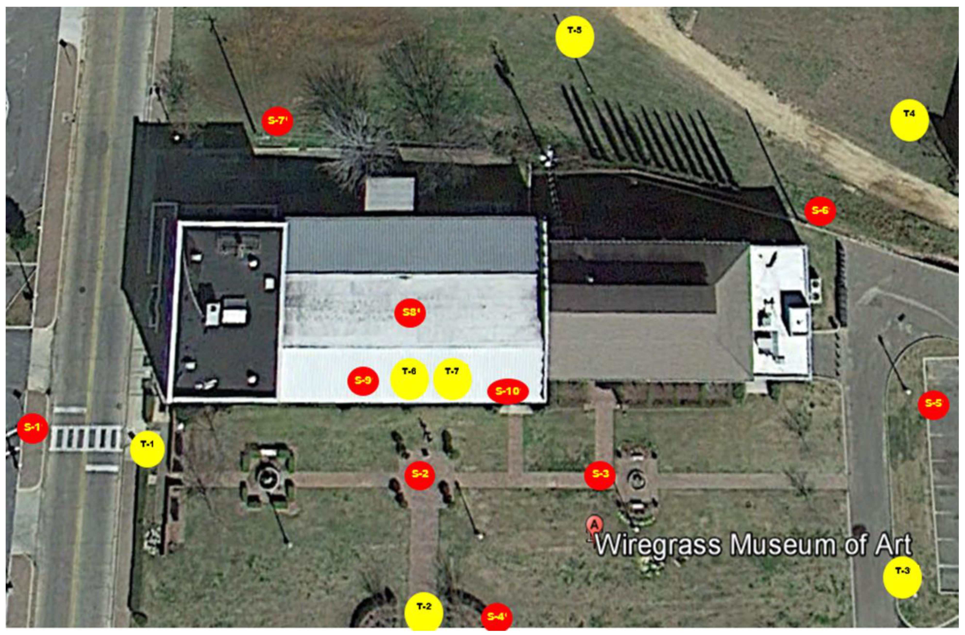
| (a) TLS Scanner Brands | (d) Control Reference | (e) Other RC Technologies Used for Data Acquisition | (f) Scan Processing Software | (g) # of Points Captured (million) | ||||||||||||||||
|---|---|---|---|---|---|---|---|---|---|---|---|---|---|---|---|---|---|---|---|---|
| Article | Country of Heritage Site | Year of Survey | FARO | Leica | Trimble | Other | (b) TLS Coverage | (c) # of Scans | GCP | Target | SfM | UAV | T.S. | GPS | Other | FARO SCENE | Leica Cyclone | Autodesk ReCap | Other | |
| [44] | Italy | 2012 and 2017 | ✓ | Ext. and Int. | 58 | ✓ | ✓ | ✓ | 3DReshaper | |||||||||||
| [47] | Jordan | ✓ | 11 | ✓ | ✓ | ✓ | ||||||||||||||
| [48] a | Saudi Arabia | ✓ | 123 | ✓ | ✓ | ✓ | ✓ | ✓ | 10,600 | |||||||||||
| [12] b | Saudi Arabia | ✓ | ✓ | ✓ | ✓ | ✓ | ✓ | ✓ | ||||||||||||
| [73] | Spain | 2019 | ✓ | Ext. and Int. | 7 | ✓ | ||||||||||||||
| [74] | Spain | 2016 | ✓ | ✓ | ||||||||||||||||
| [58] | Spain | 2021 | ✓ | ✓ | ✓ | |||||||||||||||
| [75] | Saudi Arabia | ✓ | Ext. and Int. | 100+ | ✓ | ✓ | ✓ | ✓ | ||||||||||||
| [56] | Italy | ✓ | ✓ | |||||||||||||||||
| [62] | Italy | ✓ | ✓ | ✓ | ||||||||||||||||
| [59] | Italy | 2020 | ✓ | Ext. and Int. | 65 | ✓ | ✓ | Handheld scanner | ||||||||||||
| [51] | Italy | ✓ | 213 | ✓ | ✓ | ✓ | ✓ | |||||||||||||
| [22] | Italy | 2021 | ✓ | Ext. and Int. | ✓ | ✓ | ✓ | ✓ | ✓ | ✓ | ||||||||||
| [65] | Italy | 2019 | ✓ | ✓ | ||||||||||||||||
| [76] a | Italy | ✓ | ||||||||||||||||||
| [77] b | Italy | ✓ | 182 | ✓ | ✓ | |||||||||||||||
| [78] | ||||||||||||||||||||
| [52] | Italy | 2021 | Ext. and Int. | 47 | ✓ | ✓ | ✓ | ✓ | ✓ | |||||||||||
| [64] | Italy | 2018 | ✓ | Ext. | 3 | ✓ | ✓ | 3D Zephyr | ||||||||||||
| [79] | Italy | 2020 | ✓ | ✓ | ✓ | ✓ | ||||||||||||||
| [72] | Brazil | 2016 | ✓ | ✓ | ✓ | |||||||||||||||
| [53] | Spain | 2019 | ✓ | Ext | 107 | ✓ | ✓ | ✓ | ✓ | ✓ | ✓ | ✓ | 182 | |||||||
| [45] | Spain | 2019 | ✓ | Ext. and Int. | 108 | ✓ | ✓ | ✓ | ✓ | ✓ | 214 | |||||||||
| [69] | Poland | 2017 | ✓ | Ext. and Int. | 7 | ✓ | ||||||||||||||
| [66] | Portugal | 2021 | ✓ | 3 | ✓ | Three-dimensional photo, Ground Penerating Radar (GPR); X-ray and SEM + EDX tests | 1345 | |||||||||||||
| [80] | Italy | 2018 | ✓ | Ext. | ✓ | ✓ | ✓ | |||||||||||||
| [81] | China | 2019 | ✓ | Ext. | 35 | ✓ | ✓ | ✓ | ✓ | Trimble Realwoks | ||||||||||
| [41] | Spain | 2020 | ✓ | Ext. | ✓ | ✓ | Thermal images | ✓ | PolyWorks | |||||||||||
| [14] | Egypt | 2019 | Z + F IMAGER | 160 | ✓ | ✓ | ||||||||||||||
| [54] | Portugal | 2019 | ✓ | Ext. and Int. | 95 | ✓ | ✓ | ✓ | ✓ | |||||||||||
| [49] | Italy | 2019 | ✓ | Ext. and Int. | 69 | ✓ | ✓ | ✓ | 1200 | |||||||||||
| [50] | Italy | 2019 | ✓ | Ext. and Int. | 64 | ✓ | 1014 | |||||||||||||
| [71] | Portugal | 2019 | ✓ | Ext. and Int. | 8 | ✓ | CloudCompare | |||||||||||||
| [42] a | Spain | |||||||||||||||||||
| [35] b | Spain | ✓ | Ext. and Int. | 15 | ✓ | ✓ | ✓ | ✓ | 103 | |||||||||||
| [82] | Spain | 2018 | ✓ | ✓ | ||||||||||||||||
| [40] c | ||||||||||||||||||||
| [5] | ||||||||||||||||||||
| [83] | Italy | 2018 | ✓ | Ext. and Int. | 256 | ✓ | 3D photo, wearable laser scanner | |||||||||||||
| [63] | Vietnam | 2021 | ✓ | Ext. and Int. | 162 | ✓ | Trimble Realwoks | |||||||||||||
| [84] | Spain | 2018 | ✓ | Ext. and Int. | ||||||||||||||||
| [85] | Spain | ✓ | ||||||||||||||||||
| [46] | Slovakia | ✓ | Ext. and Int. | 141 | ✓ | ✓ | ✓ | ✓ | ||||||||||||
| [57] | Italy | ✓ | Ext. | 3 | ✓ | 3DF Zephyr | ||||||||||||||
| [70] | Italy | 2020 | ✓ | 3 | ✓ | ✓ | ||||||||||||||
| [6] | Spain | 2018 | ✓ | Ext. and Int. | 99 | ✓ | ✓ | ✓ | ||||||||||||
| [43] | ||||||||||||||||||||
| [68] | Portugal | 2019 | ✓ | Ext. and Int. | 144 | ✓ | ✓ | ✓ | ✓ | GPS | ✓ | ✓ | ||||||||
| [86] | Spain | 2016 | ✓ | Ext. and Int. | 27 | ✓ | ✓ | ✓ | GPS | ✓ | 3DReshaper | |||||||||
| [55] | France | 2015 | ✓ | Ext. and Int. | 40 | ✓ | ✓ | 3DReshaper | 839 | |||||||||||
| [87] | Italy | 2017 | ✓ | Ext. and Int. | 14 | |||||||||||||||
| [60] | Cyprus | Surphased | Ext. and Int. | 73 | ✓ | ✓ | JRC Reconstructor | 2080 | ||||||||||||
| [88] | Portugal | 10 | CloudCompare | |||||||||||||||||
| [89] | Poland | 2016 | Z + F IMAGER | Ext. and Int. | 36 | ✓ | ✓ | |||||||||||||
| [90] | China | 2021 | ✓ | Ext. and Int. | 25 | ✓ | ✓ | ✓ | ✓ | |||||||||||
| [91] | Italy | 2020 | Ext and Int | 24 | ✓ | ✓ | ✓ | |||||||||||||
| [61] | S. Korea | Handheld scanner | ✓ | |||||||||||||||||
| [92] | Algeria | 2020 | ✓ | Ext. and Int. | 188 | ✓ | ✓ | ✓ | ||||||||||||
Disclaimer/Publisher’s Note: The statements, opinions and data contained in all publications are solely those of the individual author(s) and contributor(s) and not of MDPI and/or the editor(s). MDPI and/or the editor(s) disclaim responsibility for any injury to people or property resulting from any ideas, methods, instructions or products referred to in the content. |
© 2023 by the authors. Licensee MDPI, Basel, Switzerland. This article is an open access article distributed under the terms and conditions of the Creative Commons Attribution (CC BY) license (https://creativecommons.org/licenses/by/4.0/).
Share and Cite
Liu, J.; Azhar, S.; Willkens, D.; Li, B. Static Terrestrial Laser Scanning (TLS) for Heritage Building Information Modeling (HBIM): A Systematic Review. Virtual Worlds 2023, 2, 90-114. https://doi.org/10.3390/virtualworlds2020006
Liu J, Azhar S, Willkens D, Li B. Static Terrestrial Laser Scanning (TLS) for Heritage Building Information Modeling (HBIM): A Systematic Review. Virtual Worlds. 2023; 2(2):90-114. https://doi.org/10.3390/virtualworlds2020006
Chicago/Turabian StyleLiu, Junshan, Salman Azhar, Danielle Willkens, and Botao Li. 2023. "Static Terrestrial Laser Scanning (TLS) for Heritage Building Information Modeling (HBIM): A Systematic Review" Virtual Worlds 2, no. 2: 90-114. https://doi.org/10.3390/virtualworlds2020006
APA StyleLiu, J., Azhar, S., Willkens, D., & Li, B. (2023). Static Terrestrial Laser Scanning (TLS) for Heritage Building Information Modeling (HBIM): A Systematic Review. Virtual Worlds, 2(2), 90-114. https://doi.org/10.3390/virtualworlds2020006