
Cropland Mapping Using Earth Observation Derived Phenological Metrics †


Abstract
:1. Introduction
2. Materials and Methods
2.1. Study Area
2.2. Satellite Images
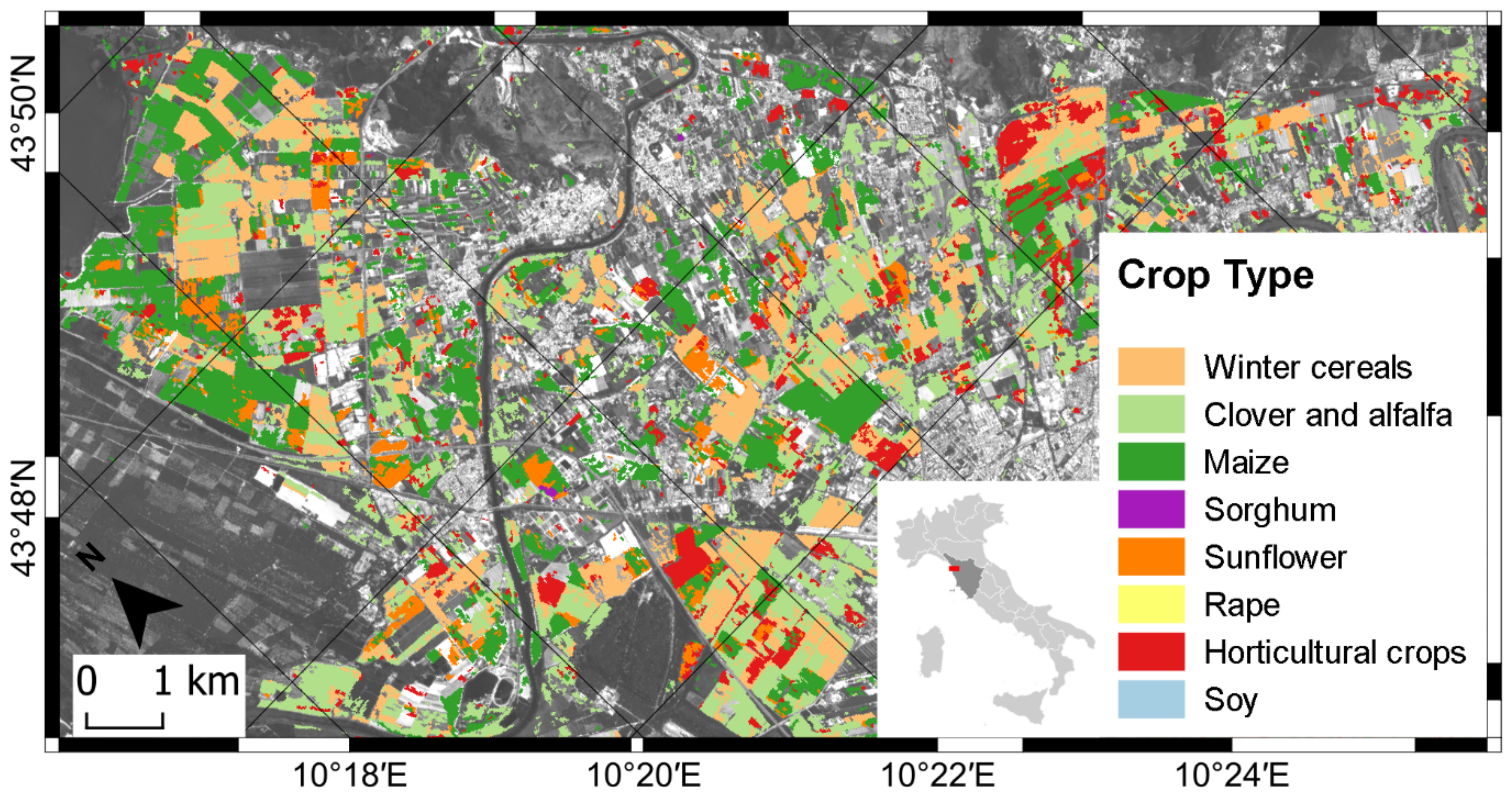
2.3. Crop Type Maps
2.4. Time Series and Temporal Predictors
2.5. Random Forest Classification
3. Results
4. Discussion
5. Conclusions
Author Contributions
Funding
Institutional Review Board Statement
Informed Consent Statement
Data Availability Statement
Acknowledgments
Conflicts of Interest
References
- Azar, R.; Villa, P.; Stroppiana, D.; Crema, A.; Boschetti, M.; Brivio, P.A. Assessing in-season crop classification performance using satellite data: A test case in Northern Italy. Eur. J. Remote Sens. 2016, 49, 361–380. [Google Scholar] [CrossRef] [Green Version]
- Taramelli, A.; Tornato, A.; Magliozzi, M.L.; Mariani, S.; Valentini, E.; Zavagli, M.; Costantini, M.; Nieke, J.; Adams, J.; Rast, M. An interaction methodology to collect and assess user-driven requirements to define potential opportunities of future hyperspectral imaging sentinel mission. Remote Sens. 2020, 12, 1286. [Google Scholar] [CrossRef] [Green Version]
- Inglada, J.; Arias, M.; Tardy, B.; Hagolle, O.; Valero, S.; Morin, D.; Dedieu, G.; Sepulcre, G.; Bontemps, S.; Defourny, P.; et al. Assessment of an Operational System for Crop Type Map Production Using High Temporal and Spatial Resolution Satellite Optical Imagery. Remote Sens. 2015, 7, 12356–12379. [Google Scholar] [CrossRef] [Green Version]
- Van Tricht, K.; Gobin, A.; Gilliams, S.; Piccard, I. Synergistic Use of Radar Sentinel-1 and Optical Sentinel-2 Imagery for Crop Mapping: A Case Study for Belgium. Remote Sens. 2018, 10, 1642. [Google Scholar] [CrossRef] [Green Version]
- Weissteiner, C.J.; López-Lozano, R.; Manfron, G.; Duveiller, G.; Hooker, J.; van der Velde, M.; Baruth, B. A Crop Group-Specific Pure Pixel Time Series for Europe. Remote Sens. 2019, 11, 2668. [Google Scholar] [CrossRef] [Green Version]
- Gao, F.; Anderson, M.C.; Hively, W.D. Detecting Cover Crop End-Of-Season Using VENµS and Sentinel-2 Satellite Imagery. Remote Sens. 2020, 12, 3524. [Google Scholar] [CrossRef]
- Vuolo, F.; Neuwirth, M.; Immitzer, M.; Atzberger, C.; Ng, W.-T. How much does multi-temporal Sentinel-2 data improve crop type classification? Int. J. Appl. Earth Obs. Geoinf. 2018, 72, 122–130. [Google Scholar] [CrossRef]
- Vrieling, A.; Meroni, M.; Darvishzadeh, R.; Skidmore, A.K.; Wang, T.; Zurita-Milla, R.; Oosterbeek, K.; O’Connor, B.; Paganini, M. Vegetation phenology from Sentinel-2 and field cameras for a Dutch barrier island. Remote Sens. Environ. 2018, 215, 517–529. [Google Scholar] [CrossRef]
- Djamai, N.; Fernandes, R.; Weiss, M.; McNairn, H.; Goïta, K. Validation of the Sentinel Simplified Level 2 Product Prototype Processor (SL2P) for mapping cropland biophysical variables using Sentinel-2/MSI and Landsat-8/OLI data. Remote Sens. Environ. 2019, 225, 416–430. [Google Scholar] [CrossRef]
- Belgiu, B.; Csillik, O. Sentinel-2 cropland mapping using pixel-based and object-based time-weighted dynamic time warping analysis. Remote Sens. Environ. 2018, 204, 509–523. [Google Scholar] [CrossRef]
- Rouse, J., Jr.; Haas, R.H.; Schell, J.A.; Deering, D.W. Monitoring Vegetation Systems in the Great Plains with ERTS. In Proceedings of the Third ERTS-1 Symposium, Washington, DC, USA, 10–14 December 1973; NASA: Washington, DC, USA, 1974; pp. 309–317. [Google Scholar]
- Lambert, M.J.; Traoré, P.C.S.; Blaes, X.; Baret, P.; Defourny, P. Estimating smallholder crops production at village level from Sentinel-2 time series in Mali’s cotton belt. Remote Sens. Environ. 2018, 216, 647–657. [Google Scholar] [CrossRef]
- De Peppo, M.; Dragoni, F.; Volpi, I.; Mantino, A.; Giannini, V.; Filipponi, F.; Tornato, A.; Valentini, E.; Nguyen Xuan, A.; Taramelli, A.; et al. Modelling the ground-LAI to satellite-NDVI (Sentinel-2) relationship considering variability sources due to crop type (Triticum durum L., Zea mays L., and Medicago sativa L.) and farm management. In Proceedings of the SPIE Remote Sensing for Agriculture, Ecosystems, and Hydrology XXI, Strasbourg, France, 9–11 September 2019; SPIE Press: Strasbourg, France, 2019; Volume 11149, p. 111490I. [Google Scholar] [CrossRef]
- Lebourgeois, V.; Dupuy, S.; Vintrou, É.; Ameline, M.; Butler, S.; Bégué, A. A Combined Random Forest and OBIA Classification Scheme for Mapping Smallholder Agriculture at Different Nomenclature Levels Using Multisource Data (Simulated Sentinel-2 Time Series, VHRS and DEM). Remote Sens. 2017, 9, 259. [Google Scholar] [CrossRef] [Green Version]
- Hagolle, O.; Huc, M.; Desjardins, C.; Auer, S.; Richter, R. MAJA Algorithm Theoretical Basis Document. Available online: https://doi.org/10.5281/zenodo.1209633 (accessed on 7 December 2017).
- Weiss, M.; Baret, F. S2 ToolBox Level 2 Products: LAI, FAPAR, FCOVER. 2016. Available online: https://step.esa.int/docs/extra/ATBD_S2ToolBox_L2B_V1.1.pdf (accessed on 31 March 2019).
- Stineman, R.W. A consistently well behaved method of interpolation. Creat. Comput. 1980, 6, 54–57. [Google Scholar]
- Filipponi, F.; Smiraglia, D.; Agrillo, E. Earth Observation for Phenological Metrics (EO4PM): Temporal discriminant to characterize forest ecosystems. Remote Sens. 2022, 14, 721. [Google Scholar] [CrossRef]
- Gu, L.; Post, W.; Baldocchi, D.; Black, T.; Suyker, A.; Verma, S.; Vesala, T.; Wofsy, S. Characterizing the seasonal dynamics of plant community photosynthesis across a range of vegetation types. In Phenology of Ecosystem Processes; Noormets, A., Ed.; Springer: New York, NY, USA, 2009; pp. 35–58. ISBN 978-1-4419-0026-5_2. [Google Scholar] [CrossRef] [Green Version]
- Zuur, A.F.; Ieno, E.N.; Elphick, C.S. A protocol for data exploration to avoid common statistical problems. Methods Ecol. Evol. 2010, 1, 3–14. [Google Scholar] [CrossRef]
- Bischl, B.; Lang, M.; Kotthoff, L.; Schiffner, J.; Richter, J.; Studerus, E.; Casalicchio, G.; Jones, Z.M. mlr: Machine Learning in R. J. Mach. Learn. Res. 2016, 17, 1–5. [Google Scholar] [CrossRef]
- Wright, M.N.; Ziegler, A. Ranger: A Fast Implementation of Random Forests for High Dimensional Data in C++ and R. J. Stat. Softw. 2017, 77, 1–17. [Google Scholar] [CrossRef] [Green Version]
- Wallace, C.S.A.; Thenkabail, P.; Rodriguez, J.R.; Brown, M.K. Fallow-land Algorithm based on Neighborhood and Temporal Anomalies (FANTA) to map planted versus fallowed croplands using MODIS data to assist in drought studies leading to water and food security assessments. GISci. Remote Sens. 2017, 54, 258–282. [Google Scholar] [CrossRef] [Green Version]
- Mingwei, Z.; Qingbo, Z.; Zhongxin, C.; Jia, L.; Yong, Z.; Chongfa, C. Crop discrimination in Northern China with double cropping systems using fourier analysis of time-series MODIS data. Int. J. Appl. Earth Obs. Geoinf. 2008, 10, 476–485. [Google Scholar] [CrossRef]
- Wardlow, B.; Egbert, S.; Kastens, J. Analysis of time-series MODIS 250 m vegetation index data for crop classification in the U.S. Central great plains. Remote Sens. Environ. 2007, 108, 290–310. [Google Scholar] [CrossRef] [Green Version]
- Veloso, A.; Mermoz, S.; Bouvet, A.; Le Toan, T.; Planells, M.; Dejoux, J.-F.; Ceschia, E. Understanding the temporal behavior of crops using Sentinel-1 and Sentinel-2-like data for agricultural applications. Remote Sens. Environ. 2017, 199, 415–426. [Google Scholar] [CrossRef]
- Mueller-Warrant, G.W.; Sullivan, C.; Anderson, N.; Whittaker, G.W. Detecting and correcting logically inconsistent crop rotations and other land-use sequences. Int. J. Remote Sens. 2016, 37, 29–59. [Google Scholar] [CrossRef]

| Name | Description | Unit | Importance | ||
|---|---|---|---|---|---|
| NDVI | LAI | NDVI | LAI | ||
| avg | Annual average value | dl | m2/m2 | 25,089.92 | 1910.118 |
| std | Standard deviation value | dl | m2/m2 | - | 4332.682 |
| min | Annual minimum value | dl | m2/m2 | - | 3486.984 |
| max | Annual maximum value | dl | m2/m2 | - | - |
| delta | Delta value | dl | m2/m2 | - | - |
| djf_avg | Winter (December, January, February) average value | dl | m2/m2 | - | - |
| djf_min | Winter (December, January, February) minimum value | dl | m2/m2 | - | - |
| djf_max | Winter (December, January, February) maximum value | dl | m2/m2 | - | - |
| jja_avg | Summer (June, July, August) average value | dl | m2/m2 | 26,029.03 | 2817.965 |
| jja_max | Summer (June, July, August) maximum value | dl | m2/m2 | 24,610.40 | - |
| SoS_doy | Start of season DoY | DoY | DoY | - | 1890.944 |
| SoS_value | Start of season value | dl | m2/m2 | - | - |
| SGS_doy | Start of growing season DoY | DoY | DoY | - | 2243.904 |
| SGS_value | Start of Growing Season value | dl | m2/m2 | 23,572.20 | - |
| PoS_doy | Peak of season DoY | DoY | DoY | - | 2611.057 |
| PoS_value | Peak of season value | dl | m2/m2 | - | - |
| EGS_doy | End of growing season DoY | DoY | DoY | - | 2653.588 |
| EGS_value | End of growing season value | dl | m2/m2 | - | - |
| EoS_doy | End of season DoY | DoY | DoY | - | - |
| EoS_value | End of season value | dl | m2/m2 | 22,521.31 | - |
| amplitude | Amplitude value | dl | m2/m2 | 27,390.47 | 2052.926 |
| greenup_doy | Greenup DoY | DoY | DoY | 47,205.49 | - |
| greenup_rate | Greenup rate | dl | m2/m2 | 24,246.63 | - |
| senescence_doy | Senescence DoY | DoY | DoY | 57,316.61 | - |
| senescence_rate | Senescence rate | dl | m2/m2 | 20,347.07 | - |
| plateau_slope | Rate of change during the maturity plateau | dl | m2/m2 | 23,675.63 | - |
| DoS | Duration of the season | Days | Days | 23,237.03 | 1627.551 |
| LMP | Length of maturity plateau | Days | Days | - | 1450.587 |
| STI | Seasonal time-integrated value | dl | m2/m2 | 22,737.46 | - |
| K = 0.54 | Classification | |||||||||
|---|---|---|---|---|---|---|---|---|---|---|
| Reference Map | Winter Cereals | Clover and Alfalfa | Maize | Sorghum | Sunflower | Rape | Horticultural Crops | Soy | Total | PA % |
| Winter cereals | 3804 | 1609 | 4 | 2 | 8 | 24 | 44 | 0 | 5495 | 69.2 |
| Clover and Alfalfa | 2974 | 17,084 | 53 | 45 | 36 | 29 | 410 | 0 | 20,631 | 82.8 |
| Maize | 2 | 21 | 528 | 62 | 215 | 0 | 71 | 11 | 910 | 58 |
| Sorghum | 1 | 1 | 8 | 11 | 11 | 0 | 9 | 0 | 41 | 26.8 |
| Sunflower | 6 | 20 | 139 | 34 | 230 | 0 | 62 | 3 | 494 | 46.6 |
| Rape | 7 | 1 | 0 | 0 | 0 | 11 | 0 | 0 | 19 | 57.9 |
| Horticultural crops | 10 | 16 | 28 | 29 | 54 | 0 | 540 | 0 | 677 | 79.8 |
| Soy | 0 | 0 | 0 | 0 | 0 | 0 | 0 | 3 | 3 | 100 |
| Total | 6804 | 18,752 | 760 | 183 | 554 | 64 | 1136 | 17 | 28,270 | OA% |
| UA % | 55.9 | 91.1 | 69.5 | 6 | 41.5 | 17.2 | 47.5 | 17.6 | OA% | 78.6 |
| K = 0.59 | Classification | |||||||||
|---|---|---|---|---|---|---|---|---|---|---|
| Reference Map | Winter Cereals | Clover and Alfalfa | Maize | Sorghum | Sunflower | Rape | Horticultural Crops | Soy | Total | PA % |
| Winter cereals | 9759 | 2510 | 0 | 0 | 0 | 62 | 40 | 0 | 12,371 | 78.9 |
| Clover and Alfalfa | 2170 | 7743 | 0 | 0 | 0 | 13 | 146 | 0 | 10,072 | 76.9 |
| Maize | 0 | 0 | 19 | 5 | 4 | 0 | 2 | 1 | 31 | 61.3 |
| Sorghum | 0 | 0 | 4 | 20 | 1 | 0 | 2 | 0 | 27 | 74.1 |
| Sunflower | 0 | 0 | 3 | 0 | 12 | 0 | 0 | 2 | 17 | 70.6 |
| Rape | 13 | 0 | 0 | 0 | 0 | 9 | 0 | 0 | 22 | 40.9 |
| Horticultural crops | 5 | 2 | 0 | 5 | 0 | 0 | 428 | 1 | 441 | 97.1 |
| Soy | 0 | 0 | 0 | 1 | 1 | 0 | 0 | 3 | 5 | 60.0 |
| Total | 11,947 | 10,255 | 26 | 31 | 18 | 84 | 618 | 7 | 22,986 | OA % |
| UA % | 81.7 | 75.5 | 73.1 | 64.5 | 66.7 | 10.7 | 69.3 | 42.9 | OA % | 78.3 |
Publisher’s Note: MDPI stays neutral with regard to jurisdictional claims in published maps and institutional affiliations. |
© 2021 by the authors. Licensee MDPI, Basel, Switzerland. This article is an open access article distributed under the terms and conditions of the Creative Commons Attribution (CC BY) license (https://creativecommons.org/licenses/by/4.0/).
Share and Cite
Filipponi, F.; Smiraglia, D.; Mandrone, S.; Tornato, A. Cropland Mapping Using Earth Observation Derived Phenological Metrics. Biol. Life Sci. Forum 2021, 3, 58. https://doi.org/10.3390/IECAG2021-09732
Filipponi F, Smiraglia D, Mandrone S, Tornato A. Cropland Mapping Using Earth Observation Derived Phenological Metrics. Biology and Life Sciences Forum. 2021; 3(1):58. https://doi.org/10.3390/IECAG2021-09732
Chicago/Turabian StyleFilipponi, Federico, Daniela Smiraglia, Stefania Mandrone, and Antonella Tornato. 2021. "Cropland Mapping Using Earth Observation Derived Phenological Metrics" Biology and Life Sciences Forum 3, no. 1: 58. https://doi.org/10.3390/IECAG2021-09732
APA StyleFilipponi, F., Smiraglia, D., Mandrone, S., & Tornato, A. (2021). Cropland Mapping Using Earth Observation Derived Phenological Metrics. Biology and Life Sciences Forum, 3(1), 58. https://doi.org/10.3390/IECAG2021-09732