Abstract
Coastal habitats are crucial in mitigating the impact of coastal hazards on society. However, the shortage of information about the role of these habitats in reducing floods in Rivers State, Nigeria, is limited. This study aims to assess the contribution of mangrove habitats in protecting coastal communities from flooding using the InVEST coastal vulnerability model (version 3.10.2). The model analyzes various data inputs and assigns relative numbers, ranging from 1 to 5, indicating different levels of exposure. Data on population, bathymetry, shoreline type, land use land cover, and continental shelf were obtained from relevant websites and the InVEST model package. The findings indicate that the mangrove habitats in Rivers State offer minimal protection against coastal flooding due to their degraded state caused by oil spills and over-exploitation. Additionally, sandy beaches provide little to no protection, and the socio-economic conditions in the communities contribute to increased vulnerability to flooding. The study recommends awareness programs to educate the public about the importance of mangroves for coastal protection in addition to their conservation and restoration.
1. Introduction
Coastal habitats play a vital role in reducing disaster vulnerability, as the connection between ecological health and disaster risk mitigation has garnered increasing global attention. This has led to the recognition of ecosystem-based disaster risk reduction (Eco-DRR) as an essential strategy for enhancing resilience and reducing risks within the global disaster reduction framework from 2015 to 2030 [1]. This framework marks a significant shift from previous international DRR strategies, introducing new hazards, such as technological and biological risks, adopting a multi-stakeholder approach to DRR, and shifting focus toward preparedness and prevention [1]. Another key advancement is the integration of habitats into risk assessments, which helps stakeholders understand the relationship between habitat health and disaster reduction [2]. Despite this growing awareness, accessible models that simulate scenarios of different habitat conditions remain limited, prompting an increase in integrated models [3,4]. Consequently, spatial models have become extensively used in habitat management and ecological health assessments [5]. This has driven the advancement of spatial techniques for evaluating habitat benefits and applying them to development planning, a trend initially promoted by the 2005 Millennium Habitat Assessment [6,7,8]. These methods have supported marine protection policies and informed decision-making in regions such as Haiti, the Great Bahamas, and the Republic of Congo [9,10].
Despite being the most populated regions on Earth, coastal regions are growing increasingly vulnerable as a consequence to the changing climatic [11]. The populations whose sources of livelihood depend solely on marine and coastal habitats are most affected by these impacts [12]. As a result, communities that rely on these habitats for recreational opportunities, food production, economic development, and shoreline security are negatively impacted [13]. With increasing urbanization, climate and population growth, the threat to habitats would also increase [14]. As a result, biodiversity and habitat services are lost [15].
A study by [16] reported on the initiatives to support communities in acclimatizing to the changing climate through nature-based solutions (NbS), which leverages biodiversity and the benefits of habitats in alleviating the impacts of the changing climate [17], leading to economic growth and conservation of coastal habitats [18]. The European Union and International Union on Conservation of Nature influenced the concept of solutions inspired by nature among the scientific community. This idea of NbS originated from dialogues on habitat services, green infrastructure, and climate adaptation [19]. The ability to reduce climate vulnerability sets NbS aside from anthropogenic solutions [20]. Several societal concerns, including food security, climate crisis and flooding, are been mitigated using NbS [21,22]. As an emerging concept, NbS encompasses all the approaches that leverage a healthy habitat in shielding individuals and properties from the impacts of a changing climate. They include ecosystem-based adaptation, ecotourism, blue and green infrastructure and economy. Thus, increasing their capacity to reduce disaster and increase resilience in rural and urban regions [23].
One of the existential threats of a changing climate has been observed in increased temperature [24]. This affects people, habitat functions and biodiversity, in addition to impacts from increased urbanization, land use degradation and deforestation [25]. However, NbS can be used to combat these social challenges [26]. Climate change is defined as any change that contributes to anthropogenic activities that alter the arrangement of the global atmosphere while also influencing climatic fluctuations in nature which is observed for a period of time [24]. These changes can be seen in irregularities in temperature and rainfall patterns [27] which negatively impact coastal and marine habitats.
Nigeria is home to the largest and third-largest mangrove forests in Africa and globally, respectively [28]. According to studies, mangrove forests are the most intensively used globally [29], with a greater portion situated in the Niger Delta region. An earlier study by [30] highlighted oil spills, overexploitation and deforestation as contributory factors to mangrove deforestation and degradation. With the increasing global awareness of NbS to flooding, more studies are required to deepen the knowledge of the protective role mangroves offer in flood reduction and to justify the awareness creation, especially in Rivers State of Nigeria. An analysis by [31], reported a decline in the mangrove forests of the area, which decreases their protective role and reduces coastal resilience. Previous studies have focused on assessing ecological vulnerability [32], drivers of vulnerability [33], flood vulnerability [30], vulnerability index [34], coastal vulnerability assessment [32], and the impact of oil spillage on habitats in the Niger Delta area [35]. However, no study has assessed the role of mangroves in flood reduction in the region. It is against this background that this study aimed to use the InVEST CV model to assess the role of mangroves in flood reduction. The Natural Capital Project (NatCap Project) developed the model, which is a software that enables stakeholders to visualise disaster risk under various habitat conditions [36]. This model is scenario-driven and offers scientifically based data on how habitat condition influences exposure to flood risk [37], consequence of the changing climate [38], thereby making it an appropriate tool for Eco-DRR and CCA. It has a user-friendly interface that allows for a variety of modelling and data proficiency [39].
2. Materials and Methods
One of the largest deltas in Africa is situated in the southeastern sector of Nigeria’s coastline (Figure 1) [40]. Geographically, it is low-lying and covers about 2.8% of the landmass, with its northern part extending south of Onitsha, a western portion bordering the estuary of the Benin River, and an eastern part abutting the estuary of the Imo River. The climate is affected by both the dry and warm northeast airmass that blows across the country from November to February and the warm and wet southwest air mass that brings rain from March to October. The region also experiences seasons of storm surges between the months of November and February.
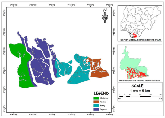
Figure 1.
Map of Nigeria showing Rivers State and the study area.
The methodology for assessing coastal vulnerability involved the downloading of open-sourced datasets; bathymetry, natural habitat (mangrove), continental shelf, shoreline geomorphology, digital elevation model (DEM), and wind/wave data, from open-source websites and the Natural Capital Project website (refer to the data set table for details).
These datasets were imported into ArcMap 10.8, where they were georeferenced to the coordinate system of the study area. Each dataset was standardized by assigning exposure values on a scale from 1 to 5 (refer to Natural Capital Project manual), representing different levels of exposure across the study area. Once pre-processed, the datasets were imported into the InVEST Coastal Vulnerability model, version 3.10.2, and the model was run to generate vulnerability (scenario) maps and a coastal exposure index.
The output provided a spatial representation of exposure levels based on ecological and physical conditions of the area. These outputs were subsequently visualized and analyzed in ArcMap 10.8 to support the assessment of coastal vulnerability and the protective role of mangrove habitats.
2.1. Coastal Exposure
The InVEST CV model, version 3.10.2 was used in the study to evaluate the coastal exposure along Rivers State coast [41]. The objective was to evaluate the contribution of mangrove habitats to flood reduction in coastal areas, (Figure 2) shows a schematic diagram of how the model works. The model was used to pinpoint communities that are more exposed to flood and regions where mangroves have the best chance to shield coastal residents from flood. The main output is a vulnerability map showing areas of low, intermediate, and high exposure (Figure 3, Figure 4, Figure 5 and Figure 6). The InVEST CV model was used as it (1) considers the biological and geophysical aspects of the region and (2) has a minimal data requirement suitable for data-poor countries. The model is based on the assumption that coastal habitats provide a strong defence against flood risk [42], and this ranking is based on the understanding that healthy habitats provide more protection than degraded habitats [43]. It also assumes that habitats that penetrate the water column like the mangroves offer greater protection than the weak and seasonal habitats like the salt marshes [44]. The model inputs include raster and shapefiles of bathymetry, natural habitat (mangrove), continental shelf, shoreline geomorphology, and digital elevation model (DEM) (see Table 1) whereas the outputs are the vulnerability maps (see Figure 3, Figure 4, Figure 5 and Figure 6 and Table 2) and (Figure 2) shows a schematic diagram of how the model works.
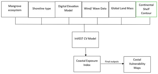
Figure 2.
Flowchart on the inputs and outputs of the InVEST CV model.
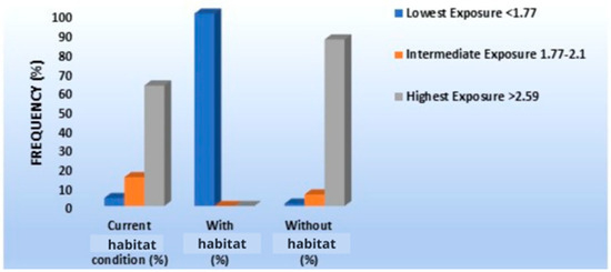
Figure 3.
Exposure of the shoreline segments to various scenarios of habitat condition.
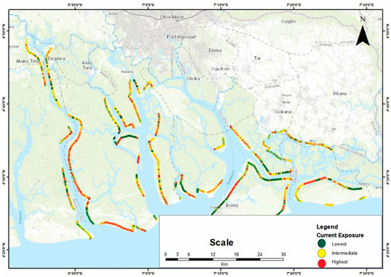
Figure 4.
A vulnerability map of the “current condition” scenario.
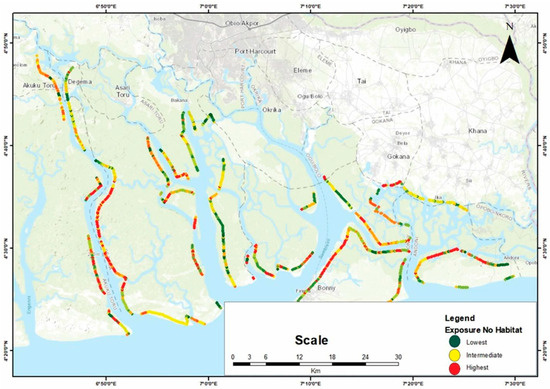
Figure 5.
A vulnerability map of the “without mangrove” scenario.
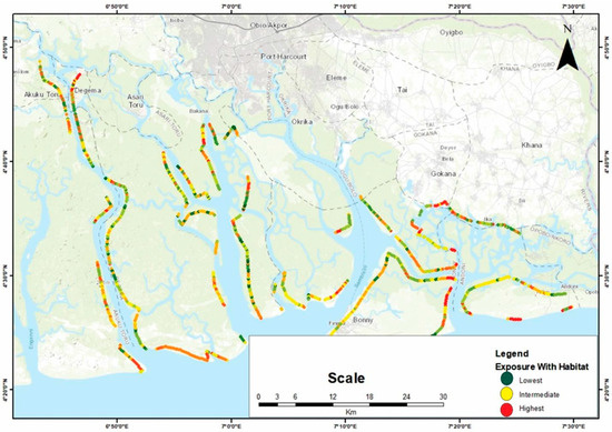
Figure 6.
A vulnerability map of the “with mangrove” scenario.

Table 1.
The data requirements used in the CV model.
Table 2.
Summary of Protective role of mangrove habitats.
This table presents the distribution of exposure levels in both scenarios, highlighting the significant difference in vulnerability between the two conditions.
2.2. Coastal Exposure Index
A qualitative index that grades coastal areas based on relative exposure is produced by the model. It incorporates various observed data on wind, wave, digital elevation model, shoreline type, global land mass, mangrove data and geomorphology to evaluate the impact of floods on exposure; habitat type is an optional variable. The geometric average of each variable rankings—which ranges from lowest, with rank as 1 and highest, with rank as 5—was used to determine the coastal exposure.
where R signifies the numerical assessment of the biogeographical variables. All variables are weighed equally, which is one of the limitations of the model [41].
Exposure Index = (RMangrove habitatRShoreline typeRDigital Elevation ModelRWind/Wave dataRGlobal Land MassRContnental Shelf Contour)1/6
3. Results and Discussion
3.1. Exposure with Current Habitat Conditions
About 77% of the research region is extremely susceptible to flooding under the existing ecological conditions, compared to 18% who are just slightly exposed and 5% who are barely affected (Figure 4).
3.2. Exposure Without Habitat Scenario
To determine how mangroves reduce a community’s vulnerability to floods, exposure under current and without mangrove scenarios were compared. In contrast to the existing situation, the whole coastline would be highly exposed without mangroves; 92% of it would be vulnerable to coastal flooding, and only 1% would be at minimal risk (Figure 5). Most of the communities are classified as being at high risk of floods.
The area’s mangrove habitats are deteriorating, which is why exposure has increased. The primary causes of mangrove deterioration in the study area are incidents of oil spills and over-exploitation of mangroves.
3.3. Exposure with Habitat Scenario
The “exposure with mangrove” scenario will offer more protection. When this scenario was compared to the ’current habitat condition’ scenario, it was discovered that there would be less exposure along the whole coastline. The percentage of low exposure increased to 100%. (Figure 6). Lower exposure is particularly important at the state’s sandy beaches.
The 3 scenarios in this study highlighted the varying degrees of flood protection provided by mangroves, which significantly reduced exposure in their healthiest state. Coastal Vulnerability Index (CVI) methodologies are commonly used to quantify coastal areas’ susceptibility to natural hazards, often relying on physical factors such as slope, tidal range, wave height, and shoreline erosion. However, many traditional CVI models lack an ecological component, making it challenging to fully understand the contribution of habitats like mangroves to coastal resilience. This limitation has prompted studies to explore models that integrate habitat services, such as the InVEST Coastal Vulnerability model, which can illustrate the role of habitats in reducing exposure to hazards like coastal flooding [39,45,46]. The InVEST Coastal Vulnerability model, developed by the Natural Capital Project, provides significant advantages by quantifying how habitats like mangroves reduce vulnerability to flood impacts. Unlike traditional CVIs that often assess vulnerability based solely on physical parameters, InVEST allows for an analysis that includes ecological variables such as habitat health, type, and spatial extent. In this study, the model revealed that exposure to coastal flooding was highest under the “without mangrove” scenario (92%), followed by the “current condition” of the habitat (77%), and lowest in the “with habitat” scenario (0%), where the mangroves were considered in pristine condition. This stark contrast demonstrates the powerful role that healthy mangrove habitats play in mitigating flood risk, aligning with previous studies that habitats provide critical protective functions [47,48,49]. By integrating the mangroves’ condition into its assessment, the InVEST model provides a nuanced view that highlights the impact of habitat degradation. For instance, the degraded state of mangroves in the study area, due to unsustainable activities such as deforestation, urbanization, and oil spills, contributes to lower resilience and protection against floods. This degradation, as cited by [34], has reduced the mangrove volume, which weakens their protective function. In the “current condition” scenario, where mangroves were partially degraded, exposure to flooding remained high. The study’s findings align with earlier study that has established a direct correlation between habitat health and disaster risk reduction [47,48,50,51,52].
The added value of the InVEST model lies in its ability to inform policymakers and stakeholders about areas where habitat restoration could significantly reduce flood risk. The model’s visual outputs provide stakeholders with a powerful tool to communicate the role of mangroves in building resilient coastal communities and to advocate for policies that protect these critical habitats. This aligns with broader goals in disaster risk reduction (DRR) planning, where ecosystem-based approaches are gaining recognition as cost-effective, sustainable solutions. By pinpointing regions where mangroves contribute most to flood defense, the model supports effective coastal zoning and sustainable land-use planning [53,54].
However, the InVEST model also has limitations. Its effectiveness depends heavily on the availability and accuracy of spatial and ecological data, which can be challenging to obtain in regions with limited environmental monitoring resources. Additionally, while InVEST includes the ecological role of habitats, it may not fully account for complex human-environment interactions or rapid land-use changes that can alter vulnerability dynamics over time. As such, while InVEST provides a valuable perspective on habitat services, complementary models and ground-truthing remain essential to capture the full scope of factors influencing coastal vulnerability [39,45,46].
In summary, the InVEST Coastal Vulnerability model advances traditional CVI methodologies by integrating ecological factors, offering a holistic understanding of how mangrove health and coverage influence flood risk reduction. The model underscores that well-preserved mangroves offer substantial flood protection, whereas degraded habitats fall short in their protective role. By identifying optimal areas for eco-DRR projects, this model can guide investment in mangrove conservation, supporting both disaster risk management and sustainable coastal development. The advantages that coastal habitats offer for tourism and real estate development were noted in the findings of a study by [46] which is in line with the manual by NatCap [54]; nevertheless, this relationship has not yet reached its full potential in this study area. The findings of this study show that restoration and preservation of mangroves can enhance both flood resilience and economic opportunities, such as tourism and real estate development, while reducing the potential loss of assets in vulnerable regions [55] like Rivers State, Nigeria.
4. Conclusions
The results show that these coastal habitats provide limited protection in the case of flood risk. However, the diverse scenarios indicated the places where habitats can give maximum protection, areas of exposure and prospects for conservation, afforestation, and restoration. Therefore, the authors propose the use of InVEST CV model in disaster reduction (DRR) decisions by stakeholders. It also suggests programmes on restoration, afforestation, and conservation of mangroves in the state while also sensitizing the indigenes on the benefits of mangroves. Although these findings highlight the protective role of mangroves, it does not however propose that coastal habitats unaided are adequate to safeguard people in addition to properties from coastal flooding. Therefore, a more complete review is vital to discover a suitable solution.
Author Contributions
C.C.O.: conceptualization, writing—original draft, review and editing, methodology, data curation, visualization, formal analysis. D.W.A.: conceptualization, review and editing, resources, supervision. All authors have read and agreed to the published version of the manuscript.
Funding
This research is part of the doctoral thesis of the first author which was funded by the World Bank through the African Centre of Excellence in Coastal Resilience (ACECoR), Centre for Coastal Management, University of Cape Coast, Ghana. Grant Number is credit number 6389-G.
Institutional Review Board Statement
Not applicable.
Informed Consent Statement
Not applicable.
Data Availability Statement
All data used in this study are displayed above.
Acknowledgments
The authors are grateful to the World Bank through the African Centre of Excellence in Coastal Resilience (ACECoR), Centre for Coastal Management and the Department of Fisheries and Aquatic Science, University of Cape Coast, Ghana, for providing funds for this study.
Conflicts of Interest
The authors declare no conflicts of interest.
References
- UNISDR. The Human Cost of Natural Disasters 2015: A Global Perspective; Centre for Research on the Epidemiology of Disasters: Brussels, Belgium; UN Office for Disaster Risk Reduction: Geneva, Switzerland, 2015. [Google Scholar]
- Estrella, M.; Renaud, F.G.; Sudmeier-Rieux, K. Opportunities, challenges, and future perspectives for ecosystem-based disaster risk reduction. In The Role of Ecosystems in Disaster Risk Reduction; United Nations University Press: Tokyo, Japan, 2013. [Google Scholar]
- Beck, M.; Gilmer, B.; Ferdana, Z.; Raber, G.T.; Shepard, C.; Meliane, I.; Newkirk, S. Increasing the resilience of human and natural communities to coastal hazards: Supporting decisions in New York and Connecticut. In The Role of Ecosystems in Disaster Risk Reduction; United Nations University Press: Tokyo, Japan, 2013; pp. 140–163. [Google Scholar]
- Global Facility for Disaster Reduction and Recovery (GFDRR). Review of Open Source and Open Access Software Packages Available to Quantify Risk from Natural Hazards; International Bank for Reconstruction and Development, The World Bank: Washington, DC, USA, 2014. [Google Scholar]
- DeFries, R.; Pagiola, S.; Adamowicz, W.L.; Akcakaya, H.R.; Arcenas, A.; Babu, S.; Balk, D.; Confalonieri, U.; Cramer, W.; Falconí, F. Analytical approaches for assessing ecosystem condition and human well-being. In Ecosystems and Human Well-Being: Current State and Trends; Island Press: Washington, DC, USA, 2005; Volume 1, pp. 37–71. [Google Scholar]
- Assessment, M.E. Ecosystems and Human Well-Being: Current State and Trends; Island Press: Washington, DC, USA, 2005. [Google Scholar]
- Evaluacio’n de los Ecosistemas del Milenio de Espãna (EME). Sı’ntesis de Resultados; Fundacio’n Biodiversidad, Ministerio de Medio Ambiente, y Medio Rural y Marino: Madrid, Spain, 2011. [Google Scholar]
- Watson, R.; Albon, S.; Aspinall, R.; Austen, M.; Bardgett, B.; Bateman, I.; Bradbury, R.; Brown, C.; Bullock, J.; Burgess, J.; et al. UK National Ecosystem Assessment: Understanding Nature’s Value to Society. Synthesis of Key Findings; UNEP-WCMC: Cambridge, UK, 2011. [Google Scholar]
- Harley, C.D.; Randall Hughes, A.; Hultgren, K.M.; Miner, B.G.; Sorte, C.J.; Thornber, C.S.; Williams, S.L. The impacts of climate change in coastal marine systems. Ecol. Lett. 2006, 9, 228–241. [Google Scholar] [CrossRef] [PubMed]
- Savo, V.; Lepofsky, D.; Benner, J.P.; Kohfeld, K.E.; Bailey, J.; Lertzman, K. Observations of climate change among subsistence-oriented communities around the world. Nat. Clim. Chang. 2016, 6, 462–473. [Google Scholar] [CrossRef]
- Seto, K.C.; Fragkias, M.; Güneralp, B.; Reilly, M.K. A meta-analysis of global urban land expansion. PLoS ONE 2011, 6, e23777. [Google Scholar] [CrossRef] [PubMed]
- Artmann, M.; Breuste, J. Cities built for and by residents: Soil sealing management in the eyes of urban dwellers in Germany. J. Urban Plan. Dev. 2015, 141, A5014004. [Google Scholar] [CrossRef]
- Seddon, N.; Smith, A.; Smith, P.; Key, I.; Chausson, A.; Girardin, C.; Turner, B. Getting the message right on nature—based solutions to climate change. Glob. Change Biol. 2021, 27, 1518–1546. [Google Scholar] [CrossRef]
- CBD. Voluntary Guidelines for the Design and Effective Implementation of EbA to Climate Change Adaptation and Disaster Risk Reduction and Supplementary Information; CBD Technical Series No. 93; Secretariat of the Convention on Biological Diversity: Montreal, QC, Canada, 2019; p. 93. Available online: https://www.cbd.int/doc/publications/cbd-ts-93-en.pdf (accessed on 23 May 2022).
- Goddard, M.A.; Dougill, A.J.; Benton, T.G. Scaling up from gardens: Biodiversity conservation in urban environments. Trends Ecol. Evol. 2010, 25, 90–98. [Google Scholar] [CrossRef]
- Cohen-Shacham, E.; Walters, G.; Janzen, C.; Maginnis, S. Nature-Based Solutions to Address Global Societal Challenges; IUCN: Gland, Switzerland, 2016; Volume 97, pp. 2016–2036. [Google Scholar]
- Balian, E.; Eggermont, H.; Le Roux, X. Outputs of the strategic foresight workshop “nature-based solutions in a BiodivERsA context”. In Proceedings of the BiodivERsA Workshop Report 2014, Brussels, Belgium, 11–12 June 2014. [Google Scholar]
- Bauduceau, N.; Berry, P.; Cecchi, C.; Elmqvist, T.; Fernandez, M.; Hartig, T.; Tack, J. Towards an EU Research and Innovation Policy Agenda for Nature-Based Solutions & Re-Naturing Cities: Final Report of the Horizon 2020 Expert Group on Nature-Based Solutions and Re-Naturing Cities; EU: Austria, Belgium, 2015. [Google Scholar]
- Kabisch, N.; Frantzeskaki, N.; Pauleit, S.; Naumann, S.; Davis, M.; Artmann, M.; Bonn, A. Nature-based solutions to climate change mitigation and adaptation in urban areas: Perspectives on indicators, knowledge gaps, barriers, and opportunities for action. Ecol. Soc. 2016, 21, 39. [Google Scholar] [CrossRef]
- Desa, U.N. World Urbanization Prospects: The 2014 Revision; United Nations Department of Economics and Social Affairs Population Division: New York, NY, USA, 2015; p. 41. [Google Scholar]
- European Environment Agency. Climate Change, Impacts and Vulnerability in Europe 2012: An Indicator-Based Report; Office for Official Publications of the European Union: Luxembourg, 2012. [Google Scholar]
- Kabisch, N.; Korn, H.; Stadler, J.; Bonn, A. Nature-Based Solutions to Climate Change Adaptation in Urban Areas: Linkages Between Science, Policy, and Practice; Springer Nature: Berlin, Germany, 2017. [Google Scholar]
- UNFCCC. National Adaptation Programmes of Action. 2011. Available online: http://unfccc.int/national_reports/napa/items/2719.php (accessed on 20 January 2014).
- Adopted IPCC. Climate Change 2014 Synthesis Report; IPCC: Geneva, Switzerland, 2014; pp. 1059–1072. [Google Scholar]
- Singh, S.; Singh, J.S. Microbial biomass associated with water-stable aggregates in forest, savanna and cropland soils of a seasonally dry tropical region, India. Soil Biol. Biochem. 1995, 27, 1027–1033. [Google Scholar] [CrossRef]
- FAO. Management and Utilization of the Mangroves in Asia and the Pacific; FAO: Rome, Italy, 1997; p. 319. [Google Scholar]
- Mmom, P.C.; Arokoyu, S.B. Mangrove Forest depletion, biodiversity loss and traditional resources management practices in the Niger Delta, Nigeria. Res. J. Appl. Sci. Eng. Technol. 2010, 2, 28–34. [Google Scholar]
- Kamalu, O.J.; Wokocha, C.C. Land resource inventory and ecological vulnerability: Assessment of Onne area in Rivers State, Nigeria. Res. J. Environ. Earth Sci. 2011, 3, 438–447. [Google Scholar]
- Fadairo, O.; Olajuyigbe, S.; Adelakun, O. Drivers of vulnerability to climate change and adaptive responses of forest-edge farming households in major agro-ecological zones of Nigeria. GeoJournal 2023, 88, 2153–2170. [Google Scholar] [CrossRef]
- Ologunorisa, T.E. An assessment of flood vulnerability zones in the Niger Delta, Nigeria. Int. J. Environ. Stud. 2004, 61, 31–38. [Google Scholar] [CrossRef]
- Omo-Irabor, O.; Olobaniyi, S.B.; Akunna, J.; Venus, V.; Maina, J.M.; Paradzayi, C. Mangrove vulnerability modelling in parts of Western Niger Delta, Nigeria using satellite images, GIS techniques and Spatial Multi-Criteria Analysis (SMCA). Environ. Monit. Assess. 2011, 178, 39–51. [Google Scholar] [CrossRef]
- Oloyede, M.O.; Williams, A.B.; Ode, G.O.; Benson, N.U. Coastal vulnerability assessment: A case study of the Nigerian coastline. Sustainability 2022, 14, 2097. [Google Scholar] [CrossRef]
- Benson, A. Social and environmental drivers of climate change vulnerability in the Niger Delta region, Nigeria. Eur. J. Environ. Earth Sci. 2020, 1. [Google Scholar] [CrossRef]
- Balogun, V.S.; Onokerhoraye, A.G. Climate change vulnerability mapping across ecological zones in Delta State, Niger Delta Region of Nigeria. Clim. Serv. 2022, 27, 100304. [Google Scholar] [CrossRef]
- Akpan, E.E. Environmental consequences of oil spills on marine habitats and the mitigating measures—The Niger delta perspective. J. Geosci. Environ. Prot. 2022, 10, 191–203. [Google Scholar] [CrossRef]
- Tallis, H.T.; Ricketts, T.; Guerry, A.D.; Nelson, E.; Ennaanay, D.; Wolny, S.; Sharp, R. InVEST 2.1 Beta User’s Guide: Integrated Valuation of Ecosystem Services and Tradeoffs; The Nature Conservancy: Hong Kong, China, 2011. [Google Scholar]
- Guerry, A.D.; Silver, J.; Beagle, J.; Wyatt, K.; Arkema, K.; Lowe, J.; Hamel, P.; Griffin, R.; Wolny, S.; Plane, E.; et al. Protection and restoration of coastal habitats yield multiple benefits for urban residents as sea levels rise. NPJ Urban Sustain. 2022, 2, 13. [Google Scholar] [CrossRef]
- Mooney, P.F. The effect of human disturbance on site habitat diversity and avifauna community composition in suburban conservation areas. Ecosyst. Sustain. Dev. 2011, 144, 13–26. [Google Scholar]
- Daily, G.C.; Kareiva, P.M.; Polasky, S.; Ricketts, T.H.; Tallis, H. Mainstreaming natural capital into decisions. In Natural Capital: Theory and Practice of Mapping Ecosystem Services, Kindle Edition; Kareiva, P., Tallis, H., Ricketts, T.H., Daily, G.C., Polasky, S., Eds.; Oxford University Press: Oxford, UK, 2011. [Google Scholar]
- Durotoye, A. The Nigerian State at a Critical Juncture: The Dilemma of a Confused Agenda; University of Leipzig: Leipzig, Germany, 2000; Volume 38, pp. 1–28. [Google Scholar]
- Natural Capital Project. InVEST Coastal Vulnerability Model 3.0.0 Documentation. 2014. Available online: https://naturalcapitalproject.stanford.edu/software/invest/invest-downloads-data (accessed on 1 December 2023).
- Peduzzi, P.; Velegrakis, A.; Estrella, M.; Chatenoux, B. Integrating the role of ecosystems in disaster risk and vulnerability assessments: Lessons from the Risk and Vulnerability Assessment Methodology Development Project (RiVAMP) in Negril, Jamaica. In The Role of Ecosystems in Disaster Risk Reduction; United Nations University Press: Tokyo, Japan, 2013; pp. 109–139. [Google Scholar]
- European Union. Mapping and Assessment of Ecosystems and Their Services: Indicators for Ecosystem Assessments Under Action 5 of the EU Biodiversity Strategy to 2020. 2nd Report. 2014. Available online: http://ec.europa.eu/environment/nature/knowledge/ecosystem_assessment/pdf/2ndMAESWorkingPaper.pdf (accessed on 28 April 2015).
- Guannel, G.; Ruggiero, P.; Faries, J.; Arkema, K.; Pinsky, M.; Gelfenbaum, G.; Kim, C.K. Integrated modeling framework to quantify the coastal protection services supplied by vegetation. J. Geophys. Res. Ocean. 2015, 120, 324–345. [Google Scholar] [CrossRef]
- Hammar-Klose, E.S.; Thieler, E.R. Coastal Vulnerability to Sea-Level Rise: A Preliminary Database for the US Atlantic, Pacific, and Gulf of Mexico Coasts (No. 68); US Geological Survey: Reston, VA, USA, 2001. [Google Scholar]
- McKenzie, E.; Irwin, F.; Ranganathan, J.; Hanson, C.; Kousky, C.; Bennett, K.; Paavola, J. Incorporating ecosystem services in decisions. In Natural Capital: Theory and Practice of Mapping Ecosystem Services; Oxford University Press: Oxford, UK, 2011; pp. 339–355. [Google Scholar]
- Arkema, K.K.; Guannel, G.; Verutes, G.; Wood, S.A.; Guerry, A.; Ruckelshaus, M.; Silver, J.M. Coastal habitats shield people and property from sea-level rise and storms. Nat. Clim. Chang. 2013, 3, 913–918. [Google Scholar] [CrossRef]
- Bayani, N.; Barthélemy, Y. Integrating ecosystems in risk assessments: Lessons from applying InVEST models in data-deficient countries. In Ecosystem-Based Disaster Risk Reduction and Adaptation in Practice; Springer: Berlin/Heidelberg, Germany, 2016; pp. 227–254. [Google Scholar]
- Sutton-Grier, A.E.; Sandifer, P.A. Conservation of wetlands and other coastal ecosystems: A commentary on their value to protect biodiversity, reduce disaster impacts, and promote human health and well-being. Wetlands 2019, 39, 1295–1302. [Google Scholar] [CrossRef]
- Ai, B.; Tian, Y.; Wang, P.; Gan, Y.; Luo, F.; Shi, Q. Vulnerability Analysis of Coastal Zone Based on InVESTModel in Jiaozhou Bay, China. Sustainability 2022, 14, 6913. [Google Scholar] [CrossRef]
- PLoS ONE Staff. Correction: Future coastal population growth and exposure to sea-level rise and coastal flooding-a global assessment. PLoS ONE 2015, 10, e0131375. [Google Scholar]
- Silver, J.M.; Arkema, K.K.; Griffin, R.M.; Lashley, B.; Lemay, M.; Maldonado, S.; Moultrie, S.H.; Ruckelshaus, M.; Schill, S.; Thomas, A.; et al. Advancing Coastal Risk Reduction Science and Implementation by Accounting for Climate, Ecosystems, and People. Front. Mar. Sci. 2019, 6, 556. [Google Scholar] [CrossRef]
- Langridge, S.M.; Hartge, E.H.; Clark, R.; Arkema, K.; Verutes, G.M.; Prahler, E.E.; O’Connor, K. Key lessons for incorporating natural infrastructure into regional climate adaptation planning. Ocean. Coast. Manag. 2014, 95, 189–197. [Google Scholar] [CrossRef]
- Turner, I.L.; Harley, M.D.; Drummond, C.D. UAVs for coastal surveying. Coast. Eng. 2016, 114, 19–24. [Google Scholar] [CrossRef]
- Umechuruba, C.I. Health impact assessment of mangrove vegetation in an oil spilled site at the Bodo West field in Rivers State, Nigeria. J. Appl. Sci. Environ. Manag. 2015, 9, 69–73. [Google Scholar]
Disclaimer/Publisher’s Note: The statements, opinions and data contained in all publications are solely those of the individual author(s) and contributor(s) and not of MDPI and/or the editor(s). MDPI and/or the editor(s) disclaim responsibility for any injury to people or property resulting from any ideas, methods, instructions or products referred to in the content. |
© 2025 by the authors. Licensee MDPI, Basel, Switzerland. This article is an open access article distributed under the terms and conditions of the Creative Commons Attribution (CC BY) license (https://creativecommons.org/licenses/by/4.0/).