Article

Assessment of Habitat Risks Caused by Human Activities and Integrated Approach to Marine Spatial Planning: The Case of Sriracha District—Sichang Island

1
Key Laboratory of Mariculture, Ministry of Education, College of Fisheries, Ocean University of China, Qingdao 266003, China
2
Department of Marine and Coastal Resources, Lak Si, Bangkok 10210, Thailand
3
Research Center for Coastal Zone Science and Marine Development Strategy, The First Institute of Oceanography, Ministry of Natural Resources, No. 6, Xianxialing Road, Qingdao 266061, China
*
Authors to whom correspondence should be addressed.
Coasts 2023, 3(3), 190-208; https://doi.org/10.3390/coasts3030012
Submission received: 18 May 2023 / Revised: 6 July 2023 / Accepted: 6 July 2023 / Published: 10 July 2023

Abstract

:
According to the Thailand’s National Strategy (2017-2036) and National Reform Plans, various tools, techniques, or methods are necessary to collect and investigate data for the effective preservation and protection of the country’s natural resources. We aimed to apply various tools and methods for integrated coastal management in Thailand. This study used the InVEST models, including the habitat quality (HQ) and habitat risk assessment (HRA) models, to evaluate the natural habitat quality and cumulative human activity risk in the Sriracha district and Sichang Islands, Thailand. The HQ model revealed the presence of abundant ecological services and high quality natural habitats. We observed habitat degradation in the mooring zone, city area, forests, and coral reefs, with moderate risk to distinct habitats. Our findings identified two potential scenarios. Conservation scenarios exhibited a lower HRA ratio compared to current and development scenarios. Overall, the results showed the effectiveness of the InVEST model in evaluating habitat risk under both present and simulated conditions. Our study highlights the importance of informed management plans and policy-making processes to achieve planned coastal management goals.

1. Introduction

Marine and coastal ecosystems worldwide are facing threats from human activities. These threats are leading to habitat degradation and loss of biodiversity. The implementation of the scientific method helps to manage the use of natural resources effectively. Our research applied the InVEST model to assess the habitat risks caused by human activities and develop effective strategies for marine spatial planning. The invest model offers the advantage of being open-source software, possessing resilience, and expanding upon the ecosystem-based management approaches. Furthermore, these services can provide further justification for the sustainable management and conservation of natural resources [1]. This integration results in a flexible structure that readily adapts to local conditions, thereby enhancing its effectiveness in evaluating and improving marine and coastal management [2].
Sriracha city has the second-highest GDP after Bangkok [3], a crucial sector for the country’s economy. The district of Sriracha is a Thai coastal area with great potential for transportation and economic growth [4]. The coastal area provides diverse ecosystem services, including provisioning, regulating, cultural, recreational, aesthetic, and spiritual services. The marine ecosystem, with its high biodiversity and productivity, plays a vital role in maintaining the balance of land and water ecosystems [5]. Society is experiencing fundamental shifts as a result of urbanization and economic growth, increasing natural resource consumption [6]. In recent years, marine transportation, fishery activities, pollutants discharges, recreation, renewable energy generation, urbanization, agriculture, and pollution from industries have all significantly increased in the ocean. These activities continue to have detrimental effects on the marine environment [7,8]. To understand how future land-use and land-cover (LULC) changes will affect the environment, it is important to use multiple models and methods. These tools help estimate the impacts of different factors that influence the modification of land use and cover in different scenarios [9]. Thailand’s sea is vital for natural resources, energy, transportation, recreation, tourism, research, and data storage. To address growing human pressures and conflicts, environmental policies advocate integrated management of marine biodiversity [10]. Coral ecosystems have significance for people in developing countries. These ecosystems provide a range of essential ecosystem services, including food supply, livelihood opportunities, carbon sequestration, and storm protection, making them vital resources that must be protected and conserved for the benefit of both present and future generations [11,12,13]. Coastal ecosystems, especially coral reefs, play a crucial role in mitigating the impact of rising human activity in the coastal zone by providing multiple functions such as wave reduction, sediment retention, erosion prevention, vertical accretion, and storm surge and debris control [14,15]. However, they are still vulnerable to human activities [16,17].

1.1. Marine and Coastal Resources

The Sriracha district, located on the eastern coast of the Gulf of Thailand, is characterized by hilly terrain that supports agriculture, coastal aquaculture, and industry. Surasak, Bueng, Nong Kham, and Bang Lamung are subdistricts that make up the Laem Chabang coastline, where the industrial zone and the country’s most important port are situated [18]. The city of Sriracha has been included in the Eastern Economic Corridor (EEC) development project area in order to expand Thailand’s market and production base for the free flow of commodities, services, investment, and labor [19]. The objective of the EEC Development Plan is to enhance the port’s capability to meet future demand for international maritime cargo. Furthermore, the abundant nutrient supply from the Bangpakong River into Sriracha Bay creates an optimal environment for cultivating oysters and green mussels, making it an attractive location for aquaculture [20], with a seven-kilometer green mussel aquaculture. Koh Sichang (Sichang Island) is located 12 km off the coast of Sriracha district in the Gulf of Thailand and is part of the Chonburi province. It is a mountainous island comprised of nine islands with a total area of around 800,000 square meters and no rivers, streams, or marshes. There are prominent tourist sites, an important historical site, and a fishing place in the area. The water area surrounding the Sichang Island is a vital mooring and transfer goods area for bulk cargo, as well as a site for significant coral research in Thailand.

1.2. Marine and Coastal Resources

Thailand’s marine and coastal system provides essential goods and services such as food, transportation, and recreation. The Department of Marine and Coastal Resources (DMCR) defines resources as elements in marine and coastal environments, including peatlands, wetlands, and estuaries. The Sriracha district and Sichang Island benefit from abundant resources, supporting coastal communities economically and environmentally. Furthermore, the marine benthic species in these areas can serve as important indicators of the overall health and well-being of the marine environment [21]. The coastal region of Sriracha has the potential to become a hub for coastal aquaculture, playing a crucial part in the regional economy’s fishery sector. The production of green mussels contributes 51% of the Inner Gulf of Thailand’s output [22]. Other than aquaculture, tourism is also their primary industry [23]. Sriracha district and Sichang Island attract tourists with their beautiful coastline and marine environment. However, certain areas of marine and coastal resources are sensitive to human activities. Thailand’s coastal regions serve various purposes like tourism, recreation, food production, fishing, and hosting research facilities [24]. The littoral zone is a marine region impacted by tidal and longshore currents, characterized by high wave energy and abundant oxygen, sunlight, and nutrients. It encompasses coral reefs, rocky coasts, sandy beaches, and sheltered embayment, each supporting unique flora and fauna. Thailand’s beaches exhibit different erosion and sediment patterns, creating diverse habitats and contributing to coastal ecosystems [25,26,27]. Coral reefs are highly productive and biodiverse ecosystems that offer humans a plethora of benefits, including seafood, opportunities for recreation, coastal prevention, and aesthetic and cultural values [28]. Thailand’s coral reef areas spanned about 238 square kilometers across 17 provinces, according to the 2018 annual report of the DMCR. Reefs face numerous challenges, including tourism, dredging, port construction, fishing pressure, marine debris, and coral bleaching due to climate change and natural disasters. To address these issues, ecosystem-based management (EBM) frameworks are utilized to manage and preserve ecosystems and their valuable services [29,30].

1.3. Ecosystem Services in the Demonstration Areas

The marine ecosystem is vital to the overall equilibrium of land and water ecosystems. As “ecosystem services (ES)”, coastal and marine ecosystems provide numerous important benefits to their inhabitants [31]. The marine socio-ecosystem offers multiple interconnected ecosystem services tied to diverse value systems. Considering and articulating these values effectively is crucial for conserving and sustainably using marine and coastal ecosystem services amidst rapid socioeconomic and environmental changes [32]. ES valuation is typically performed on large habitats, whereas a spatially explicit analysis of ecosystem services at the local scale is required [33,34]. Human activities driven by population growth and economic expansion have led to a significant deterioration in 60% of global ecosystem services over the past 50 years. This degradation has negative consequences for the environment, altering ecological services and compromising human well-being in terms of safety, health, and social and cultural aspects. Understanding the impact of human activities on ecosystem services is essential for achieving sustainable habitats and preserving ecological environments. [35,36]. Initially, the residents of Sriracha and Koh Sichang districts engaged in fishing and aquaculture due to the sea’s potential to provide food. Sriracha Bay is still home to green mussel aquaculture, which accounts for 51% of the production in the Inner Gulf of Thailand [22]. Other marine fishing products include shellfish, squid, and shrimp [37]. According to [27], the sea areas of the district of Koh Sichang have a complete coral reef, with Porites lutea, Pavona sp., Acropora sp., and artificial reefs for the restoration of aquatic resources. Sriracha and Sichang Island’s coastal communities have expanded to meet tourism demands. They offer cultural ecosystem services through traditional houses, city pillar shrines, shrines, temples, and opportunities for education and recreation [38].

1.4. Influence of Environmental Factors on Marine and Coastal Resources

Population and economic growth result in more people utilizing marine resources, putting increased pressure on marine and coastal ecosystems [39]. Thailand’s growing industrial, tourism, and export sectors have ongoing implications for marine and coastal resources. The country faces challenges with land use in these areas, as industries, urban development, and other uses encroach upon and compete for marine and coastal spaces [40]. Illegal, unreported, and unregulated (IUU) fishing, conducted in violation of fishing laws, poses significant threats to natural resources. The depletion of marine fishery resources necessitates new approaches to fisheries management. It undermines ecosystem health, species survival, livelihoods, and sustainable development [41,42,43]. International trade, rapid industrialization, local resource depletion, traffic congestion, and the reduction in trade obstacles are dependent on maritime transportation [44,45]. While moored, it contributes to global air and water pollution emissions [46]. Since then, over a thousand species, including human diseases and alien species, have been discovered in ballast tanks [47]. The issue of marine pollution in Indonesia is a result of a combination of factors, including ocean–atmospheric circulation, a high population of coastal communities, and marine activities [48]. The accumulation of chemicals from the transportation hub could be harmful to marine animals [49]. Human activities driven by socioeconomic development have caused significant coastal change. Coastal development has had a profound impact on ecosystems and biodiversity, although quantitative assessments are infrequent. [50]. Coastal regions undergoing rapid development are vulnerable to flooding and the escalation of sediment, nutrient, and pathogen runoff due to the effects of land use and climate change [51]. Coastal development has degraded mangrove forests, salt marshes, seagrass meadows, oyster beds, and coral reefs, causing the loss of invaluable ecosystem goods and services for humans [52]. Southeast Asia’s marine and coastal tourism is thriving due to its beautiful beaches, coral reefs, islands, and cultural heritage. However, unplanned development to cater to the rising demand has brought negative consequences. Prioritizing environmental impact assessment, conservation efforts, and sustainable development, along with defining and revising planning standards, can help address these issues [53,54,55]. Increasing tourism and related marine activities degrade coastal ecosystems, resulting in waste overflow and resource exploitation. Issues like garbage, wastewater, construction, beach encroachment, sedimentation, and coastal erosion contribute to the deterioration of beach ecosystems and loss of scenic views [56]. Coastal aquaculture negatively impacts ecosystems through mangrove conversion, hydrological disruption, and the release of organic waste into coastal waters [57]. Coastal aquaculture destroys valuable wetlands, causing land subsidence, acidification, and salinization. It also leads to the loss of crucial ecosystem services and disrupts mangrove habitats vital for marine organisms [58,59].

1.5. Integrated Coastal Management (ICM)

Integrated coastal management (ICM) aims to achieve a sustainable coast by recognizing interrelationships among coastal and ocean environments is recognized worldwide since 1992. ICM is a dynamic concept that emphasizes adaptability to meet the diverse needs of coastal populations and integrates science and policy for effective management in complex coastal settings. The relationship between ICM and habitat assessment is vital for sustainable coastal areas; there are recognized interconnections between coastal and ocean environments [60]. ICM and habitat assessment work together to integrate science and policy, adapting and evolving to address the complex challenges of coastal management worldwide [61]. Long-term management tools for the sustainability of marine and coastal management, such as integrated coastal management (ICM), marine spatial planning (MSP), marine protected areas (MPAs), and ecosystem-based management (EBM) principles in diverse ecosystems, highlight the importance of collaboration, stakeholder involvement, and sustainable practices to ensure the long-term health and well-being of coastal ecosystems and communities [62,63]. Habitat assessment is crucial for integrated coastal management (ICM), informing decision-making, setting conservation priorities, and promoting sustainable practices to balance environmental, social, and economic needs for a sustainable coast [64,65]. Marine spatial planning (MSP) is a holistic approach to managing marine and coastal resources, using ocean zoning to balance activities, reduce conflicts, and preserve ecosystem health for the future [66,67]. Successful ecosystem-based management relies on understanding the diverse stakeholders and their interests, incorporating scientific ecological principles. Marine spatial planning (MSP) helps guide the positioning of human activities, promoting compatibility, reducing conflicts, and minimizing impacts on the environment [66,68].
Thailand adopted the Convention on Biological Diversity (CBD) in 2003 and the UN Partnership Framework 2017–2021 in July 2017 to curb sustainable development and promote Sustainable Development Goal (SDG14: Life Below Water). Currently, Thailand gives precedence to managing the marine and coastal resources; however, the negative impact of urbanization, industrialization, and tourism on coastal ecosystems has been steadily increasing [12]. The present condition of development in the Sriracha district—Sichang Island—is harmful to near-shore ecosystems such as coral reefs and marine benthic habitats. So, there is a need to study the tradeoffs between human activities and ecosystem services [2,69]. Stanford University’s Integrated Valuation of Ecosystem Services and Tradeoffs (InVEST) model provides tools for detecting threats and measuring the impact of human activities on ecosystems [70,71,72]. InVEST is an alternate method for managing natural resources that considers the potential ecosystem services in the coastal environment [73,74,75,76] and the vulnerability of stressor exposure, threat sensitivity, and resilience of the ecosystem [77]. The InVEST habitat quality model assesses habitat extent, vegetation types, and degradation levels using habitat quality and rarity as indicators of biodiversity. It combines LULC maps with data on habitat threats and responses [78]. The model uses raster data to assess habitat degradation by evaluating threats and relationships and calculating suitability and degradation degrees, providing an overall measure of habitat quality [2]. An assessment of the HQ model is based on data on key factors such as the threats to the habitats and the distance from the source of the threat, the sensitivity of the habitat to threats, and its capacity to form a habitat [72,79]. Construction, agriculture, and tourism pose the greatest threat to the natural ecosystem as a result of human influence [2,80,81,82,83,84].
The framework for assessing habitat risk can aid in organizing and enhancing the effectiveness of placing human activities by identifying areas where the combined risk from multiple activities may harm coastal and marine ecosystems and adjusting the location and extent of such activities to reduce the risk [70,85,86]. This study aims to classify environmental stressor activities, provide a scientific foundation to support the new method, and analyze the cumulative impacts of human activity that threaten marine habitats to improve policy for the preservation, restoration, and marine spatial planning of a sustainable marine and coastal zone environment.

2. Materials and Methods
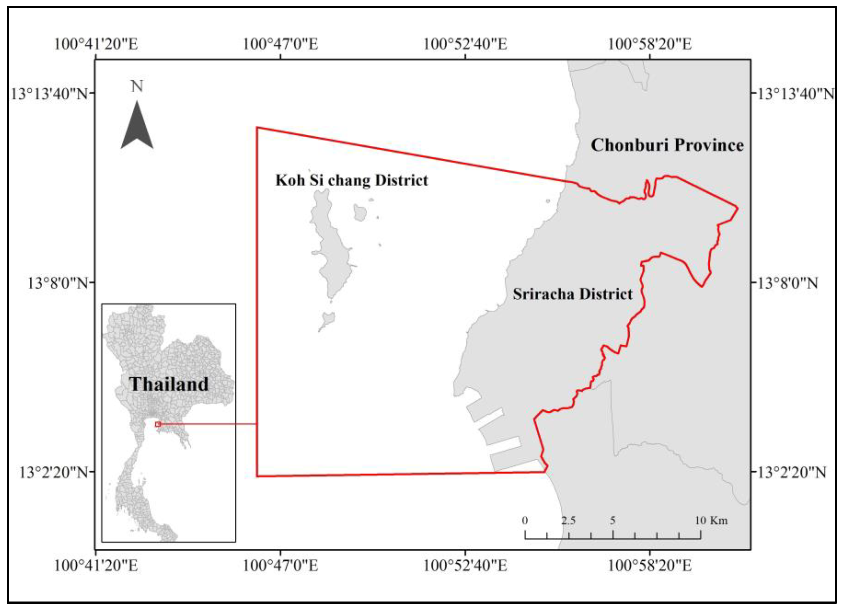
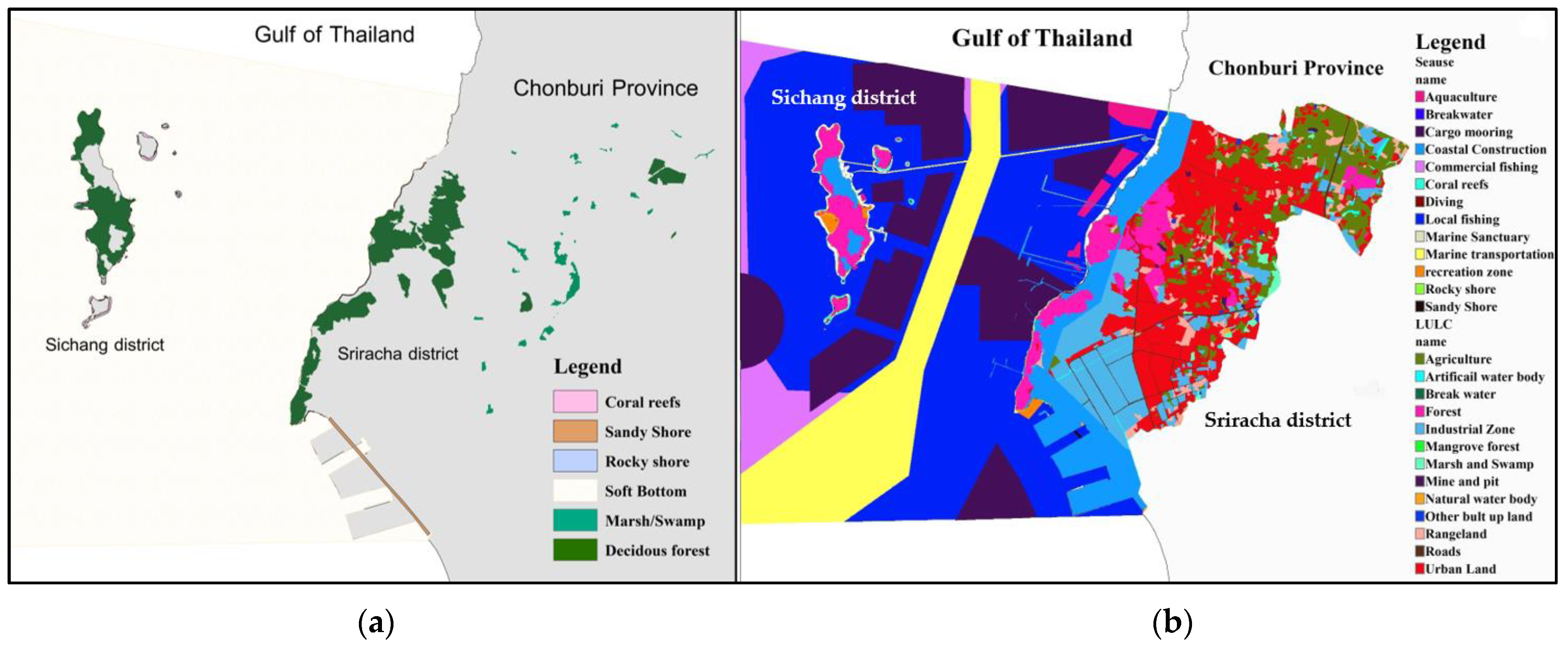
2.1. Study Area

The selection of study area is located in Chonburi province, Thailand, which consists of three subdistricts along the coast of Sriracha district and Kho Sichang district. With the rapid development in recent decades, Sichang Island and its surrounding sea area are facing increasingly eco-environmental issues. The total demonstration area, covering approximately 300 square kilometers, is shown in Figure 1. Spatial information about coastal and marine areas was collected by analyzing and compiling documents from various organizations and government publications. The data were organized in InVEST, GIS, and RS-based Excel files and shapefiles. The majority of analyses of marine habitat data utilize the data from 2017 to 2020, with the 2020 data extent being the main reference. The details of land use in the study area are presented in Figure 2. The researcher conducted a comprehensive survey of the area and collaborated with relevant agencies and locals through the use of questionnaires or by establishing a system for hearing the opinions of stakeholders. For example, Provincial Marine and Coastal Resources Committee meetings provided a platform for stakeholders to collaborate on planning for marine and coastal spatial management.

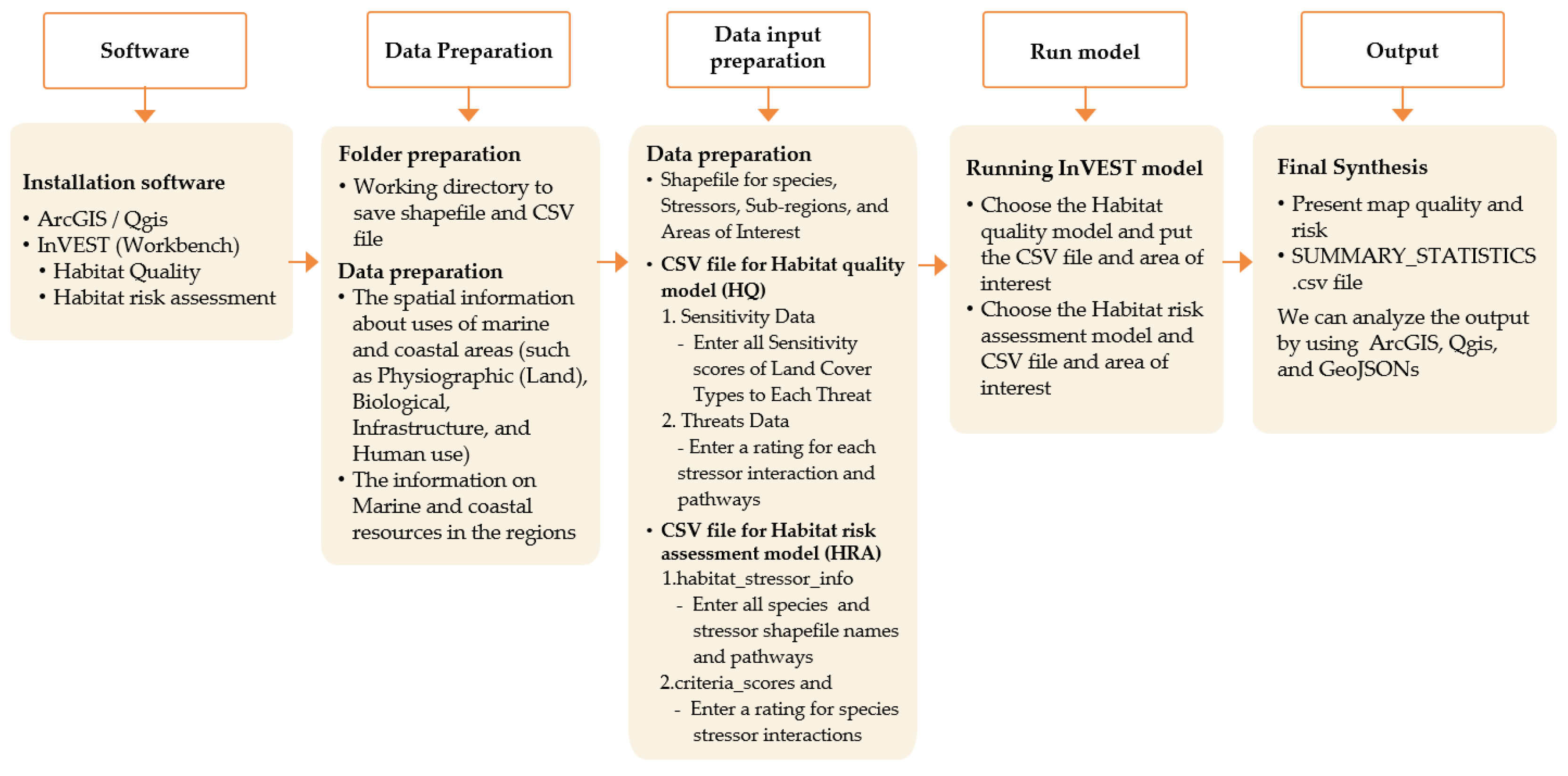
2.2. Data Collections and Data Analysis

In this study, the researcher employs the InVEST habitat risk assessment (HRA) model to assess the current risk and create two future scenarios to assess the potential risks for the future habitat areas (coral reefs and marine benthic habitats): (1) development of marine and coastal resources and (2) conservation of marine and coastal resources. Documents from various organizations and government publications were used to compile this study. The Land Development Department (LDD) and the Department of Fisheries (DOF) provided the spatial data on the uses of marine and coastal areas (such as physiographic, biological, infrastructure, and human use). DMCR provides data on marine ecosystems. For marine ecology, the majority of data analyses utilize the 2020 data extent and data from 2017 to 2020. The spatial data form was presented using InVEST, GIS, and RS-based Excel files and shapefiles. The purpose of this study was to identify land uses associated with human activities, and eight types were identified: coastal development, marine transportation, cargo mooring, commercial fisheries, local fisheries, aquaculture, recreation, and diving. Each stressor was assigned a buffer zone, which represents the distance over which the stressor’s effects extended beyond its actual footprint on the input map [25].

2.3. InVEST Model

InVEST models assess ecosystem services and their impact on human well-being, accounting for changes in ecosystem structure and function. They consider service delivery, value, and recipient activities across landscapes [87]. We apply the InVEST (Integrated Valuation of Ecosystem Services and Tradeoffs) model developed by Sharp et al. (2016) to assess the ecological impact of land use and marine and coastal changes. This service allows for the quantification of various ecosystem services such as carbon sequestration, habitat quality, and habitat risk assessment [88]. We used the InVEST model to analyze the effects of land use and marine/coastal activities on ecosystem services in the study area. Following the InVEST user manual, we gathered land cover and coastal human activities data and incorporated them into the model. Local environmental agency data on land-use land cover, activities, and natural resources were used for parameterization [89,90]. Using the InVEST model, we were able to analyze the tradeoffs and synergies between different land-use scenarios and their implications for ecosystem services provisioning [91,92]. The HQ model combines LULC and biodiversity data to generate habitat quality maps, providing essential data for initial conservation assessments. It assesses the extent, degradation, and changes over time of habitat categories in a given area. By considering land-use susceptibility and severity of threats, the model calculates habitat degradation and estimates habitat quality; the process is shown in Figure 3 [93].
The InVEST habitat risk assessment model informs coastal and marine habitat management by evaluating the impact of human activities on ecosystem services. It helps identify areas at risk from climate change and human pressures, aiding conservation prioritization [78]. The HRA model can estimate various risks associated with the influences of human activity on marine and coastal ecosystems, and its resilience component is adaptable based on the planner’s input [70,94]. It requires two dimensions, resilience, and stressor overlap properties of the habitat, as can be seen in the process in Figure 3 [76]. Both exposure (E) and consequence (C) are determined by assigning a rating (typically 1–3, with 0 = no score) to a set of criteria. The following formula is commonly used in the scientific literature:
E j k l = i = 1 N e i j k l d i j k l × w i j k l i = 1 N 1 d i j k l × w i j k l
C j k l = i = 1 N c i j k l d i j k l × w i j k l i = 1 N 1 d i j k l × w i j k l
where E j k l is the exposure score specific to habitat j, from stressor k in location l; C j k l is the consequence score, e i j k l is the exposure rating criterion i, specific to habitat j and stressor k and location l; c i j k l is the consequence rating, d i j k l represents the data quality rating, w i j k l represents the importance of weighing for criterion, and N is the number of criteria evaluated for each habitat.
The combined exposure and response values produce a risk value for each stressor-habitat combination in each grid cell. For Euclidean risk calculation, R j k l is the risk to habitat j caused by stressor k in each location l (i.e., cell l) calculated as the Euclidean distance from the origin in the exposure–consequence space by using:
R j k l = ( C j k l 1 ) 2 + ( E j k l 1 ) 2
R j k l = E j k l × C j k l
The model quantifies the cumulative risk to each habitat or species from all stressors at each grid cell. R j l is the cumulative risk for habitat or species j in cell l is the sum of all risk scores for each habitat or species:
R j l = k = 1 K R j k l
To provide an integrative index of risk across all habitats or species in a grid cell, the model also calculates ecosystem risk. Ecosystem risk, R 1 , for each grid cell l is the sum of habitat or species risk scores in that cell to assess the cumulative risk to the ecosystem from multiple stressors. Ecosystem risk will increase with an increasing number of co-occurring habitats or species:
R 1 = j = 1 J R j l
where R j l is the sum of risk scores across all habitats.
The results will be shown on the raster layer, which depicts the habitat-specific risk from all the stressors in a grid cell into four categories, where 0 = no risk, 1 = low risk, 2 = medium risk, and 3 = high risk. Cells are classified as high risk if they have cumulative risk scores of more than 66% of the total possible cumulative risk score.

2.4. Correlation Analysis

The given tables provide score values for the InVEST model, which assesses the risk of habitat degradation and loss due to various threats in marine and coastal ecosystems: Table 1 shows the scoring weights and maximum impact of different types of threats for HQ model, Table 2 indicates the sensitivity of each LULC type to different threats, such as habitat loss and damage to the structure for HRA model, and Table 3 defines and scores the exposure and consequence criteria for the HRA model.

3. Results

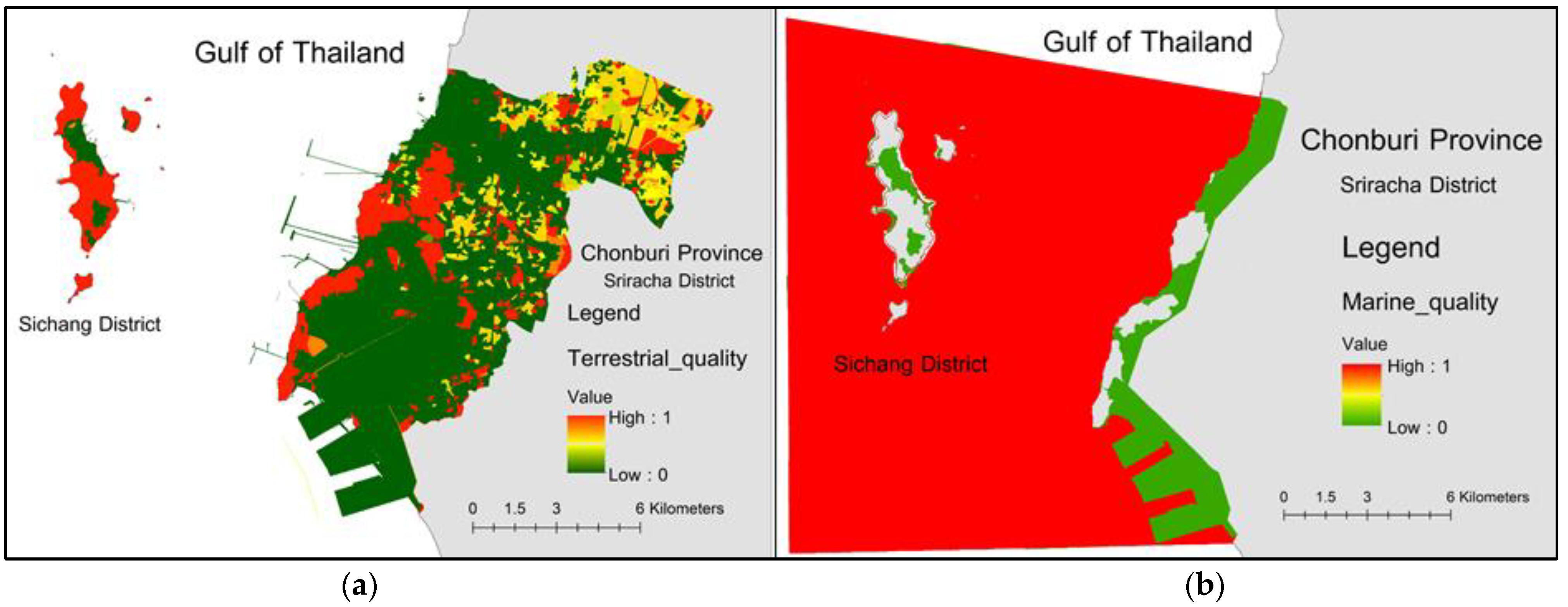
3.1. Habitat Quality

This study divided the coastal regions of Sriracha district and Koh Sichang district into two categories: marine and terrestrial. The terrestrial zone can be categorized into six primary land-use types (agricultural land, urban area, mine area, pit area, industrial area, built-up land, and public utility area). The InVEST habitat quality model revealed that the habitat area of Sriracha coasts consists of deciduous forests, mangrove forests, and marine benthic habitats (rocky and sandy shore). The current habitat quality is shown in Figure 4. The red color shows the areas that were suitable to be habitats.
Furthermore, analysis of habitat degradation revealed a range of 0.038 to 0.085 between terrestrial and marine zones. The habitats are highly susceptible to human activities and moderately impacted by nearby activities, such as fugitive dust from shipping and unloading goods (such as tapioca starch, powdered cement, pellet cement, coal, sugar, and soybean meal), the disturbance of sediment on the seabed during the anchoring or mooring of vessels, as well as from the movement of cargo using equipment such as cranes, conveyors, or loaders, mooring waste, and industrial effects, as shown in Figure 5.

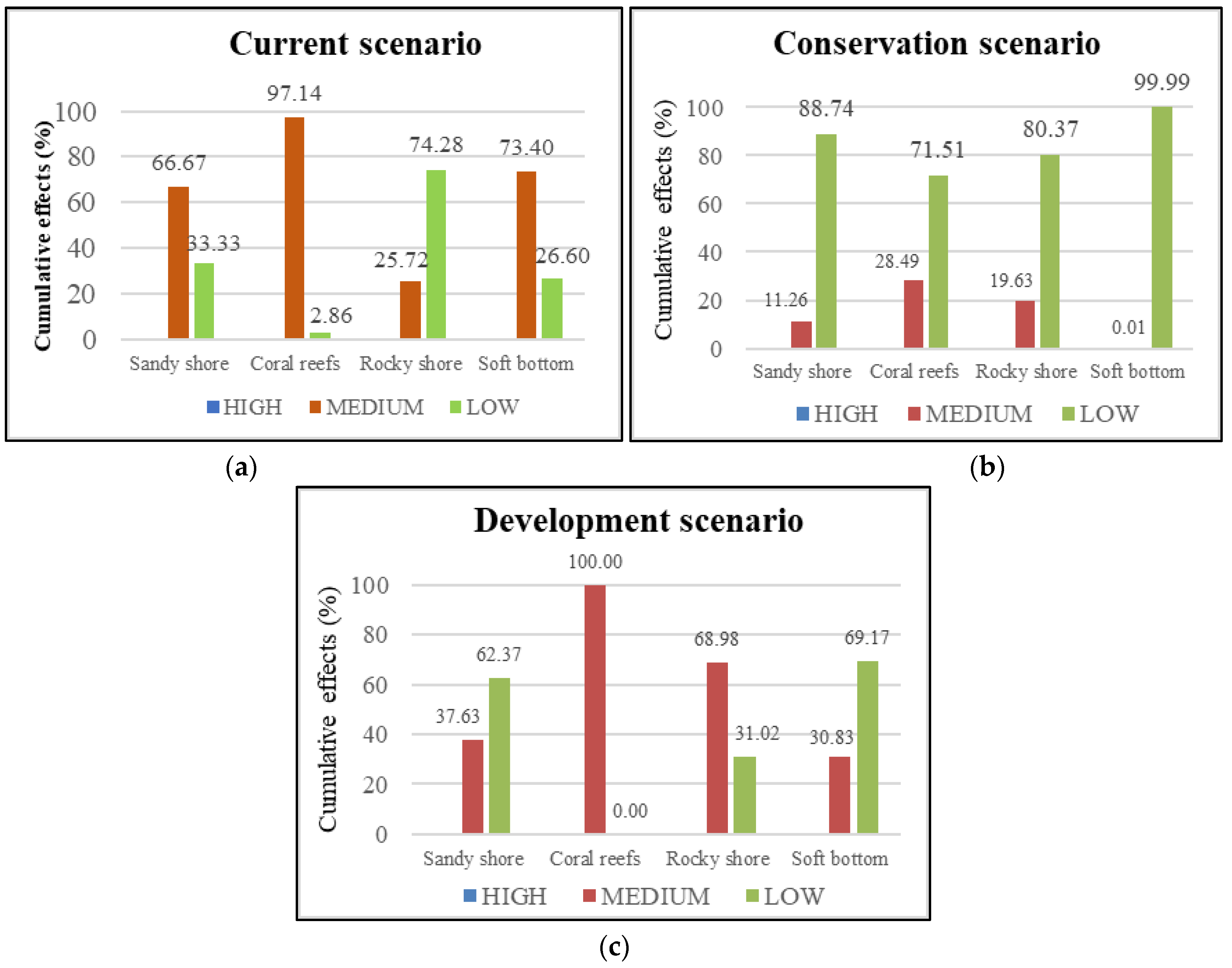
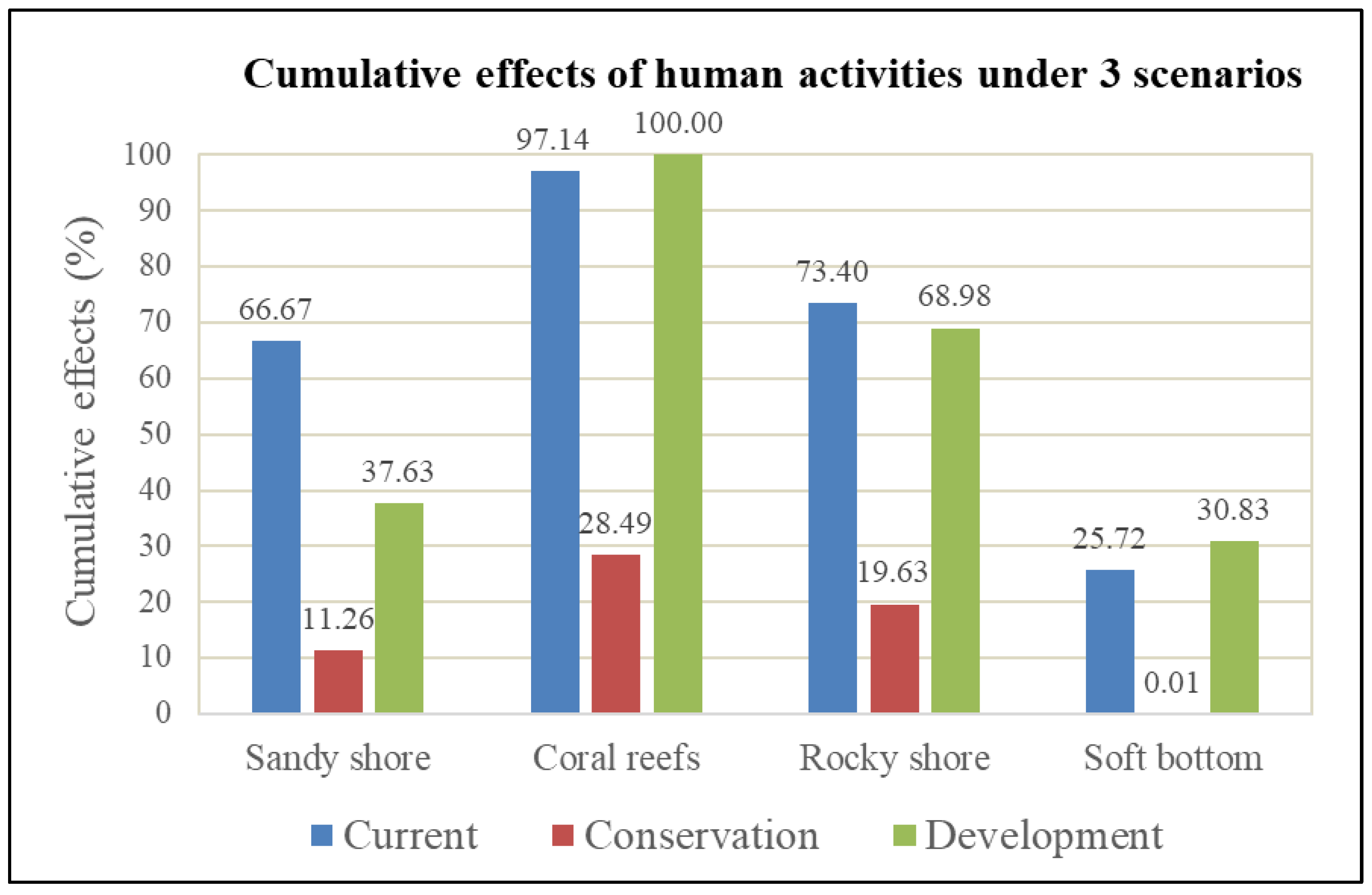
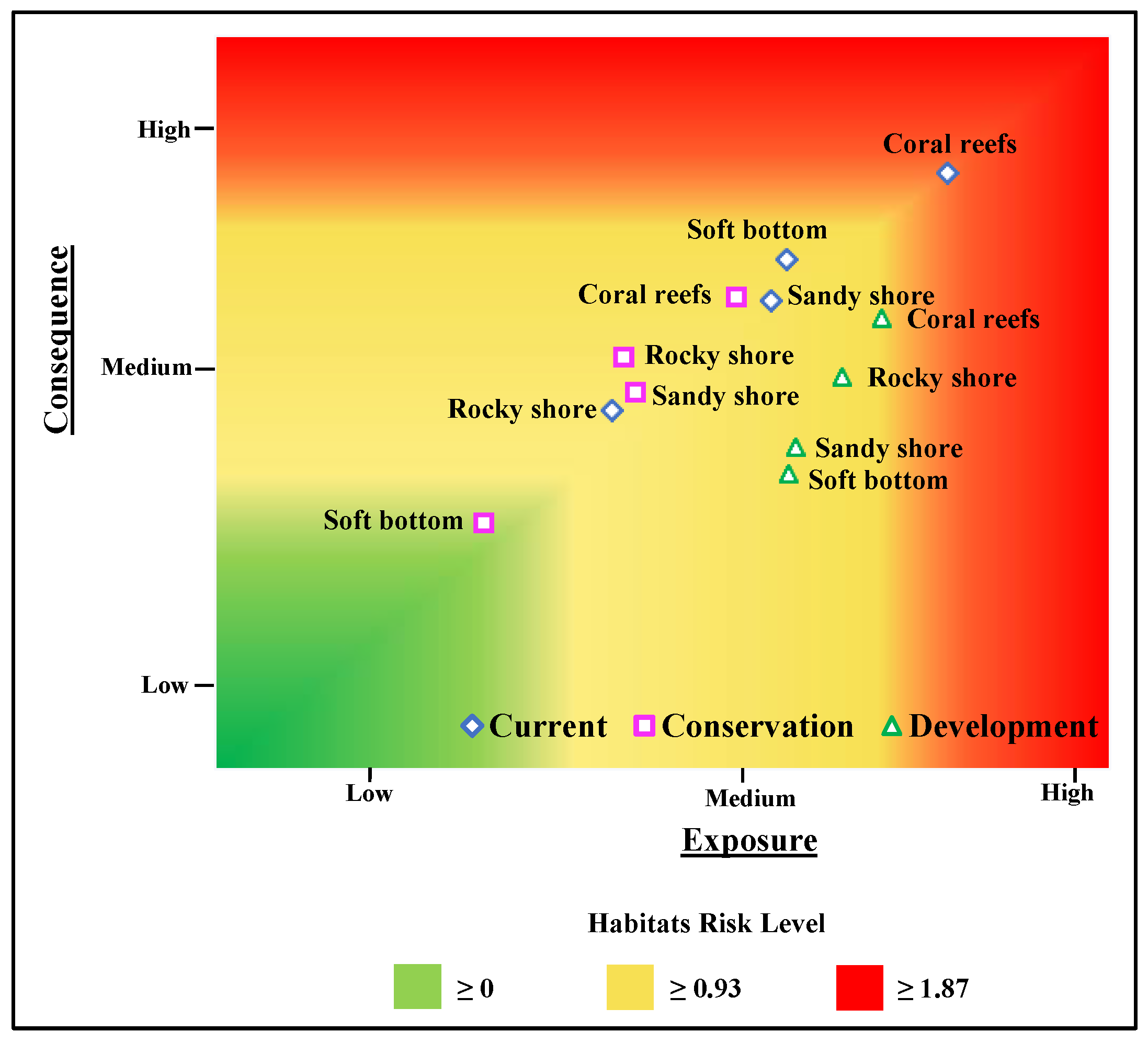
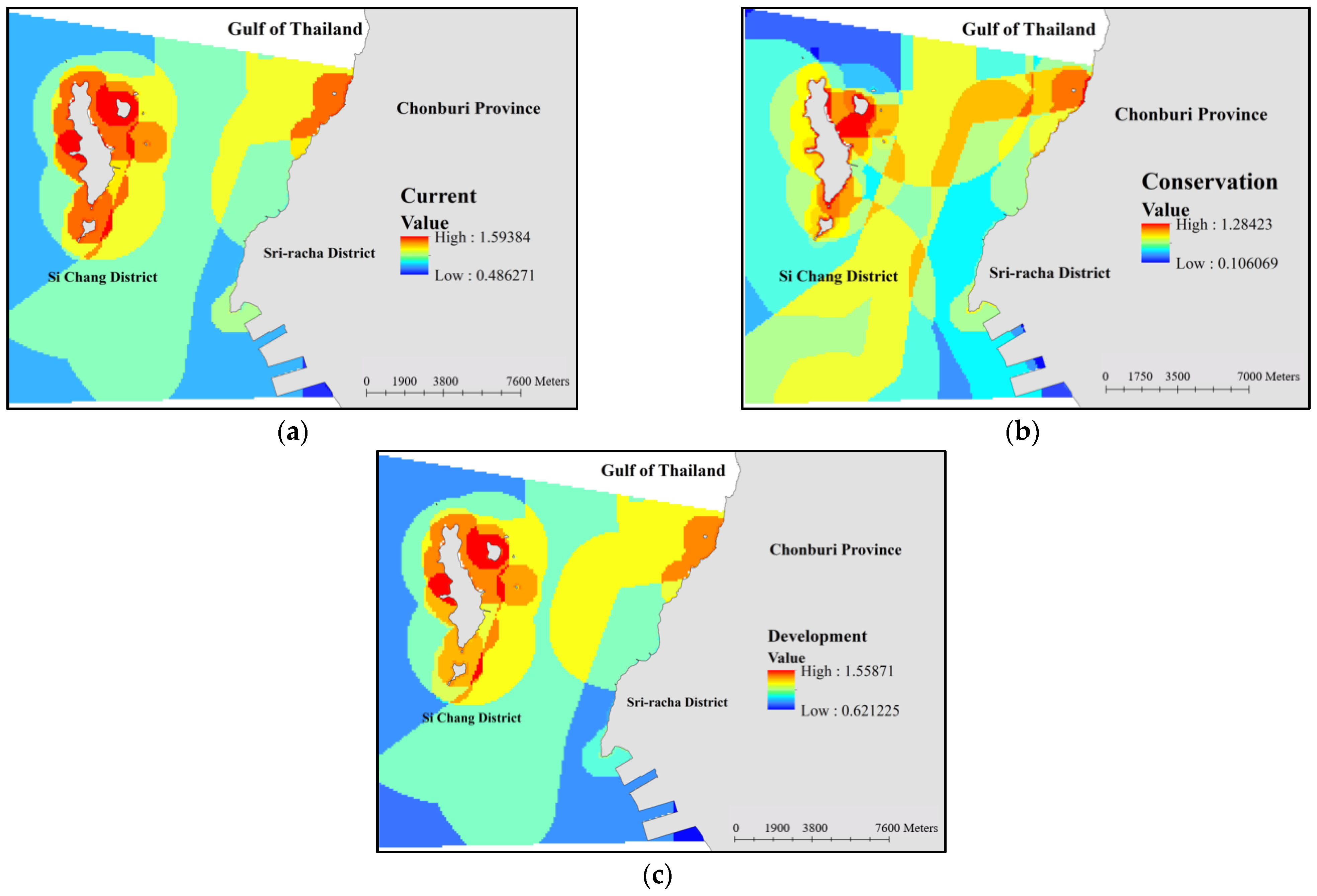
3.2. Habitat Risk Assessment

The InVEST HRA model was used to analyze the cumulative risks from human activities in 270 square kilometers of marine and coastal areas. Cells were categorized as medium risk when their cumulative risk scores ranged from 33% to 66% of the total possible cumulative risk score, encompassing both single stressors and multiple stressors. The results in Figure 6 reveal that human activities have a more pronounced impact on coral reefs compared to other habitats, both in the present situation and the projected development scenario. Coral reefs are subjected to an increasingly diverse range of threats, such as overfishing, the development of cargo terminals, constructing a residence, shipping activities, and climate change. The loss of marine benthic diversity is particularly notable in coastal regions, primarily due to conflicting utilization of coastal habitats.
The results in Figure 7a show that in the current scenarios, the coral reef area around the Sichang Island is 97.14% at moderate risk, the sandy shore is 66.67%, the rocky shore is 73.40%, and the soft bottom is 25.72%. As we created a scenario that may serve as a guideline for area management and recommended a policy with the effectiveness of minimizing stress from human activities, we found that allocating marine utilization and enhancing the effectiveness of policies and measures could reduce cumulative risks by more than 50%. The simulation of a region to conserve resources and protect marine ecosystems by zoning marine use has the lowest impact on habitats, as determined by ratings and values.
As for the results in Figure 7, the most important details in this context are that the conservation scenario decreased the cumulative risks of the coral reefs by 50.89%, while the sandy shore decreased to 11.26%, the soft bottom decreased to 0.01%, and the rocky shore decreased to 19.63%. The simulation scenario increased coastal development and marine usage to take advantage of the sea area, and the coral reefs were found to be 100% at moderate risk. The rocky shore area was found to decrease to 68.98%, the sandy shore decreased to 37.63%, the soft bottom increased to 30.83% from the current risk, and the coral reefs were discovered to be 100% at moderate risk, as shown in Figure 7c.
By comparing the conservation scenario in Figure 7b with the development scenario in Figure 7c, it was discovered that allocating marine utilization and improving the effectiveness of policies and measures can reduce habitat risks by more than 70%. As determined by ratings and values, the simulation of a region to conserve resources and protect marine ecosystems by zoning marine use will have the least impact on habitats. The HRA model’s outputs in Figure 8 and Figure 9 indicate that the current cumulative risk is greatest in the coral reefs, with a consequence range of 1.92 to 2.12. Section 2.3 describes the exposure–consequence risk plot for the three scenarios under all stressors. While developing, the risk plot can indicate shifts in risk from the current (diamonds) to conservation (square) (triangle). All cells with a risk score above 1.87 (66% of 2.83) would be classified as “high risk”.
Figure 7. The cumulative effects of human activities under (a) the current, (b) conservation, and (c) development.
Coasts 03 00012 g007

4. Discussion

The coastal regions of Sriracha district and Koh Sichang district were analyzed in this study and categorized into marine and terrestrial zones. The terrestrial zone was further classified into six primary land-use types, including agricultural land, urban area, mine and pit area, industrial area, built-up land, and public utility area. The focus of the analysis was on the habitat quality of Sriracha coasts to Sichang island, which encompassed deciduous forests, mangrove forests, coral reefs, and marine benthic habitats (rocky, sandy shore, and soft bottom). Currently, the study area is controlled refer to Section 17 in the Marine and Coastal Resources Management Promotion Act, B.E. 2558 (2015) [95]. This measure is supervised by the Department of Marine and Coastal Resources (DMCR). The theme of this section emphasizes the significance of safeguarding marine and coastal resources from substantial harm resulting from human activities [95]. The threat posed by human activities within the study areas underscores the need for appropriate measures to mitigate such risks. We utilized the Integrated Valuation of Ecosystem Services and Tradeoffs (InVEST) to assess the natural habitat quality in the demonstration areas. InVEST models of the Natural Capital Project are widely used to assess biodiversity and habitat degradation.
Rapid urbanization in certain areas can contribute to a deterioration in the quality of natural habitats as a result of habitat encroachment and environmental pollution [96]. The rapid growth in seaborne trade and vessel size drives the need for port and harbor expansion. This expansion leads to the acquisition of new areas and subsequent loss of terrestrial habitat, with significant implications for the marine ecosystem [97]. For managing and protecting the coastal and marine environment, it is necessary to collect spatial data on the location and quantity of human activity, as well as how it impacts marine habitats. The InVEST HQ model integrates data on land-use/land-cover change and biodiversity threats to generate a specialized habitat quality map for assessing the biodiversity status and habitat quality [98,99]. Our result showed that terrestrial habitat areas would diminish in the vicinity of intensive urbanization and industrial zones, whereas marine habitat degradation revealed an ecological decline in mooring areas and coastal aquaculture zones. Consistent with the study in Hangzhou, China, shows that rapid urbanization has significant negative effects on habitat quality in various areas [84], and studies in many countries have shown that the threats posed by humans, such as urbanization, industrial pollution, and agricultural productivity, can exert ecological pressure on the environment in numerous ways [2,100].
The InVEST HRA model was utilized to assess the current state and both alternative scenarios in the marine and coastal zone. Due to the focus areas, there are important marine transportation areas. The relevant field surveys and document reviews of Sriracha’s coastline area and Koh Sichang district indicate that, at present, the coastal development helps to support the country’s economic development in the sector of maritime transport. According to the annual report of the Marine Department, there are over a hundred thousand ships that anchor each year for loading and unloading goods for import and export purposes. Additionally, more than 165,000 tourists use passenger boats per year [101]. Currently, marine pollution is a problem, whether it is garbage pollution or sewage and oil discharges. Furthermore, the discharge of sewage and the impact of marine transportation have detrimental effects on both the health of coral reefs and benthic habitats. Our result shows that the cumulative risk in coral reefs is greater than in other habitats. As well as the marine benthic habitat, the results clearly indicate that there is a cumulative risk in the area as a cargo mooring and tourist harbor. In addition to the consequences of port and harbor expansion, the deposition of cargo can pose a threat to benthic habitats, while marine ecosystems may suffer from the detrimental effects of underwater noise pollution, oil spills, and the discharge of ballast water [97,102]. The cumulative risk of the coastal seafloor due to human activities, such as the mooring and transportation areas, contributes to the decline of the benthic community. Industrial effluent affects habitat conditions, causing a significant change in the substrate and flow conditions of the water [101]. Marine debris found in marine environments adversely affects marine fauna, negatively impacting over 1400 species [103,104,105,106]. According to the results of the HRA model, relocating the mooring area, expanding conservation areas, and enhancing regulations and policies can reduce the impact of all stressors. The analysis examined various management scenarios and found that zoning the region as ecologically significant would reduce the risk to habitats posed by human activities [105].
Coastal development may increase the cumulative threat to ecosystems, but executive management actions have a greater potential to reduce risk through exposure shifts than through consequence modifications [70,106]. The results of this study can be used as information to support the preparation of natural resource conservation areas refer to Sections 18, 20, 22, and 23 in the Marine and Coastal Resources Management Promotion Act, B.E. 2558 (2015) [95]. The main idea is the interest in the preservation, conservation, and revival of marine and coastal resources entails the development policies aimed at reducing the impact on resources while promoting sustainable development for the country. The integration of risk assessment for coastal and marine habitats and ecosystem models allows for the evaluation of potential social and economic implications stemming from various management strategies. Efficient allocation of marine and coastal use areas can mitigate conflicts among different activities and minimize resource damage. The preservation of natural habitats plays a crucial role in maintaining the integrity of various resources, thereby enhancing the well-being of coastal communities engaged in fisheries and tourism [107]. Moreover, well-developed transportation systems contribute to the growth of significant blue economic zones in the country. Additionally, to achieve the Sustainable Development Goals by 2030, specifically in SDG 14: Life Below Water, in terms of conserving and sustainably utilizing the oceans, seas, and marine resources of Thailand.

5. Conclusions

This study proposed a method for assessing the quality of an ecosystem and estimating the cumulative risk to habitats posed by human activities. The results indicate that the region is capable of providing high quality natural habitat and extensive ecological services, but the ecosystem remains vulnerable to human activity. In the conservation situation experiment, it is possible to reduce stress and pressure on ecosystems through resource-aware site designation and efficient management strategies. To significantly reduce the impact on habitats and the consumption of natural resources, integrated management involving the government, stakeholders, and local community networks is essential. To effectively manage marine and coastal resources, researchers should collaborate to study ecological, economic, and social factors and develop strategies to mitigate the negative effects of human activity.
This is the first study in Thailand to assess the ecosystem for management using scientific methods and instruments. The InVEST model is adaptable for users and can serve as a guide for the government, associated agencies, and planners to improve marine management planning policy. Notwithstanding, this study of the demonstration area exhibits limitations and challenges pertaining to the continuity of data recording, particularly in relation to the data on coastal area changes. The absence of enhancements in the current data collection practices can lead to contributing to inconsistencies in the outcomes. Furthermore, the existing studies are insufficient in providing a comprehensive parameter matrix for the assessment. In the future, all of the data used in the model should be collected from the current improved data to achieve accurate ecological risk assessment results.

Author Contributions

Conceptualization and Original Draft Preparation, W.U.; Methodology and Software, Z.G.; Visualization, Investigation, Supervision, and Writing—Reviewing and Editing, Y.M. and Z.Z.; Data Curation and Visualization. C.J.; Writing—Reviewing and Editing, S.S. All authors have read and agreed to the published version of the manuscript.

Funding

This research received no external funding.

Institutional Review Board Statement

Not applicable.

Informed Consent Statement

Not applicable.

Data Availability Statement

Not applicable.

Acknowledgments

The first author is thankful for funds from the Chinese Scholarship Council (CSC). This work is supported by Ocean University of China. We acknowledge the data supported by the Department of Marine and Coastal Resources, Department of Fishery, and Marine Department of Thailand. We would also like to extend our thanks to the support from the staff of the Research Center for Coastal Zone Science and Marine Development Strategy, the First Institute of Oceanography, Ministry of Natural Resources, P.R. China.

Conflicts of Interest

The authors declare no conflict of interest.

References

  1. Duarte, G.T.; Ribeiro, M.C.; Paglia, A.P. Ecosystem Services Modeling as a Tool for Defining Priority Areas for Conservation. PLoS ONE 2016, 11, e0154573. [Google Scholar] [CrossRef] [PubMed] [Green Version]
  2. Zhai, T.; Wang, J.; Fang, Y.; Qin, Y.; Huang, L.; Chen, Y. Assessing ecological risks caused by human activities in rapid urbanization coastal areas: Towards an integrated approach to determining key areas of terrestrial-oceanic ecosystems preservation and restoration. Sci. Total. Environ. 2020, 708, 135153. [Google Scholar] [CrossRef] [PubMed]
  3. World Bank Thai Flood 2011: Rapid Assessment for Resilient Recovery and Reconstruction Planning; World Bank: Washington, DC, USA, 2012.
  4. Tangvitoontham, N.; Chaiwat, P. Economic Feasibility Evaluation of Government Investment Project by Using Cost Benefit Analysis: A Case Study of Domestic PortPort A), Laem-Chabang Port, Chonburi Province. Procedia Econ. Finance 2012, 2, 307–314. [Google Scholar] [CrossRef] [Green Version]
  5. Frederick Grassle, J. Marine Ecosystems. In Encyclopedia of Biodiversity; Elsevier: Amsterdam, The Netherlands, 2013; pp. 45–55. ISBN 9780123847201. [Google Scholar]
  6. Gu, J.-D.; Wang, Y.-S. Marine coastal ecosystem and ecotoxicology. Ecotoxicology 2020, 29, 639–640. [Google Scholar] [CrossRef]
  7. OSPAR Commission. Trend Analysis of Maritime Human Activities and Their Collective Impact on the OSPAR Maritime Area. Available online: https://www.ospar.org/about/publications/page25 (accessed on 20 June 2020).
  8. Turok, I.; McGranahan, G. Urbanization and economic growth: The arguments and evidence for Africa and Asia. Environ. Urban. 2013, 25, 465–482. [Google Scholar] [CrossRef]
  9. Gomes, E.; Banos, A.; Abrantes, P.; Rocha, J.; Schläpfer, M. Future land use changes in a peri-urban context: Local stakeholder views. Sci. Total Environ. 2020, 718, 137381. [Google Scholar] [CrossRef]
  10. Buhl-Mortensen, L.; Galparsoro, I.; Fernández, T.V.; Johnson, K.; D’Anna, G.; Badalamenti, F.; Garofalo, G.; Carlström, J.; Piwowarczyk, J.; Rabaut, M.; et al. Maritime ecosystem-based management in practice: Lessons learned from the application of a generic spatial planning framework in Europe. Mar. Policy 2017, 75, 174–186. [Google Scholar] [CrossRef]
  11. Cantin, M.; Bédard, J.; Milne, H. The food and feeding of common eiders in the St. Lawrence estuary in summer. Can. J. Zool. 1974, 52, 319–334. [Google Scholar] [CrossRef]
  12. Defeo, O.; McLachlan, A.; Schoeman, D.S.; Schlacher, T.A.; Dugan, J.; Jones, A.; Lastra, M.; Scapini, F. Threats to sandy beach ecosystems: A review. Estuar. Coast. Shelf Sci. 2009, 81, 1–12. [Google Scholar] [CrossRef]
  13. Eddy, T.D.; Lam, V.W.Y.; Reygondeau, G.; Cisneros-Montemayor, A.M.; Greer, K.; Palomares, M.L.D.; Bruno, J.F.; Ota, Y.; Cheung, W.W. Global decline in capacity of coral reefs to provide ecosystem services. One Earth 2021, 4, 1278–1285. [Google Scholar] [CrossRef]
  14. OECD Responding to Rising Seas: OECD Country Approaches to Tackling Coastal Risks; OECD: Paris, France, 2019; ISBN 9789264312470.
  15. Spalding, M.D.; Ruffo, S.; Lacambra, C.; Meliane, I.; Hale, L.Z.; Shepard, C.C.; Beck, M.W. The role of ecosystems in coastal protection: Adapting to climate change and coastal hazards. Ocean Coast. Manag. 2014, 90, 50–57. [Google Scholar] [CrossRef]
  16. Thompson, R.C.; Crowe, T.P.; Hawkins, S.J. Rocky intertidal communities: Past environmental changes, present status and predictions for the next 25 years. Environ. Conserv. 2002, 29, 168–191. [Google Scholar] [CrossRef]
  17. Schaefer, N.; Mayer-Pinto, M.; Griffin, K.J.; Johnston, E.L.; Glamore, W.; Dafforn, K.A. Predicting the impact of sea-level rise on intertidal rocky shores with remote sensing. J. Environ. Manag. 2020, 261, 110203. [Google Scholar] [CrossRef] [PubMed]
  18. Nguyen, P.N.; Woo, S.-H.; Beresford, A.; Pettit, S. Competition, market concentration, and relative efficiency of major container ports in Southeast Asia. J. Transp. Geogr. 2020, 83, 102653. [Google Scholar] [CrossRef]
  19. EECO. Overall Land Use Plan. Eastern Economic Corridor Office of Thailand. Available online: https://eeco.or.th/th/overall-land-use-plan (accessed on 14 March 2020).
  20. Vichkovitten, T.; Intarachart, A.; Khaodon, K. Impact of green mussel (Perna viridis) raft-culture on benthic environment in Sriracha coastal water, Thailand. GMSARN Int. J. 2017, 11, 116–122. [Google Scholar]
  21. Kennedy, A.D.; Jacoby, C. Biological Indicators of Marine Environmental Health: Meiofauna—A Neglected Benthic Component? Environ. Monit. Assess. 1999, 54, 47–68. [Google Scholar] [CrossRef]
  22. Kumgumpol, H.; Liu, Y.; Pokavanich, T.; Alabia, I.D.; Yin, Z.; Saitoh, S.-I.; Tian, Y. Environmental Habitat Mapping of Green Mussel: A GIS-Based Approach for Sustainable Aquaculture in the Inner Gulf of Thailand. Sustainability 2020, 12, 10643. [Google Scholar] [CrossRef]
  23. McDowall, S.; Wang, Y. An Analysis of International Tourism Development in Thailand: 1994–2007. Asia Pac. J. Tour. Res. 2009, 14, 351–370. [Google Scholar] [CrossRef]
  24. Hayes, E.H.; Landis, W.G. Regional Ecological Risk Assessment of a Near Shore Marine Environment: Cherry Point, WA. Hum. Ecol. Risk Assess. Int. J. 2004, 10, 299–325. [Google Scholar] [CrossRef]
  25. Zohary, T.; Gasith, A. The Littoral Zone. In Lake Kinneret: Ecology and Management; Zohary, T., Sukenik, A., Berman, T., Nishri, A., Eds.; Springer: Dordrecht, The Netherlands, 2014; pp. 517–532. [Google Scholar]
  26. Gasith, A.; Gafny, S. Effects of Water Level Fluctuation on the Structure and Function of the Littoral Zone. In Large Lakes; Springer: Berlin/Heidelberg, Germany, 1990. [Google Scholar] [CrossRef]
  27. Department of Marine and Coastal Resources. Coastal Geomorphology. Available online: https://km.dmcr.go.th/c_56/s_77/d_2766 (accessed on 7 March 2022). (In Thai)
  28. Moberg, F.; Folke, C. Ecological goods and services of coral reef ecosystems. Ecol. Econ. 1999, 29, 215–233. [Google Scholar] [CrossRef]
  29. Ferrier-Pagès, C.; Leal, M.C.; Calado, R.; Schmid, D.W.; Bertucci, F.; Lecchini, D.; Allemand, D. Noise pollution on coral reefs?—A yet underestimated threat to coral reef communities. Mar. Pollut. Bull. 2021, 165, 112129. [Google Scholar] [CrossRef] [PubMed]
  30. Granek, E.F.; Polasky, S.; Kappel, C.V.; Reed, D.J.; Stoms, D.M.; Koch, E.W.; Kennedy, C.J.; Cramer, L.A.; Hacker, S.D.; Barbier, E.B.; et al. Ecosystem Services as a Common Language for Coastal Ecosystem-Based Management. Conserv. Biol. 2010, 24, 207–216. [Google Scholar] [CrossRef] [PubMed]
  31. Daily, G. (Ed.) Nature’s Services: Societal Dependence on Natural Ecosystems; Island Press: Washington, DC, USA, 1997; ISBN 9781559634762. [Google Scholar]
  32. Chakraborty, S.; Gasparatos, A.; Blasiak, R. Multiple values for the management and sustainable use of coastal and marine ecosystem services. Ecosyst. Serv. 2019, 41, 101047. [Google Scholar] [CrossRef]
  33. Costanza, R.; d’Arge, R.; de Groot, R.; Farber, S.; Grasso, M.; Hannon, B.; Limburg, K.; Naeem, S.; O’Neill, R.V.; Paruelo, J.; et al. The value of the world’s ecosystem services and natural capital. Nature 1997, 387, 253–260. [Google Scholar] [CrossRef]
  34. Hutchison, L.; Montagna, P.; Yoskowitz, D.; Scholz, D.; Tunnell, J. Stakeholder Perceptions of Coastal Habitat Ecosystem Services. Estuaries Coasts 2013, 38, 67–80. [Google Scholar] [CrossRef]
  35. Costanza, R.; De Groot, R.; Braat, L.; Kubiszewski, I.; Fioramonti, L.; Sutton, P.; Farber, S.; Grasso, M. Twenty years of ecosystem services: How far have we come and how far do we still need to go? Ecosyst. Serv. 2017, 28, 1–16. [Google Scholar] [CrossRef]
  36. Qi, Y.; Lian, X.; Wang, H.; Zhang, J.; Yang, R. Dynamic mechanism between human activities and ecosystem services: A case study of Qinghai lake watershed, China. Ecol. Indic. 2020, 117, 106528. [Google Scholar] [CrossRef]
  37. Department of Fisheries (DoF). The Master Plan on Thailand’s Aquaculture Development (2017–2021); Ministry of Agriculture and Cooperatives: Bangkok, Thailand, 2019.
  38. Tiprak, W. An Application of Cultural Resource to Develop Community Based Tourism in Bangphra Seaside, Sriracha District Chonburi Province. Inst. Cult. Arts J. 2017, 19, 136–143. [Google Scholar]
  39. Wang, Y.; Sun, C.; Zou, W. Study on the Interactive Relationship Between Marine Economic Growth and Marine Environmental Pressure in China. Environ. Resour. Econ. 2021, 79, 117–133. [Google Scholar] [CrossRef]
  40. Department of Marine and Coastal Resources (DMCR). The 2018 Marine and Coastal Resources and Coastal Erosion Situations of Thailand. Available online: https://www.dmcr.go.th/detailLib/4933 (accessed on 10 March 2020).
  41. Temple, A.J.; Skerritt, D.J.; Howarth, P.E.; Pearce, J.; Mangi, S.C. Illegal, unregulated and unreported fishing impacts: A systematic review of evidence and proposed future agenda. Mar. Policy 2022, 139, 105033. [Google Scholar] [CrossRef]
  42. Nasuchon, N.; Charles, A. Community involvement in fisheries management: Experiences in the Gulf of Thailand countries. Mar. Policy 2009, 34, 163–169. [Google Scholar] [CrossRef]
  43. Sander, K.; Lee, J.; Hickey, V.; Mosoti, V.B.; Virdin, J.; Magrath, W.B. Conceptualizing maritime environmental and natural resources law enforcement–The case of illegal fishing. Environ. Dev. 2014, 11, 112–122. [Google Scholar] [CrossRef]
  44. Viana, M.; Hammingh, P.; Colette, A.; Querol, X.; Degraeuwe, B.; de Vlieger, I.; van Aardenne, J. Impact of maritime transport emissions on coastal air quality in Europe. Atmos. Environ. 2014, 90, 96–105. [Google Scholar] [CrossRef]
  45. Christiansen, M.; Fagerholt, K.; Nygreen, B.; Ronen, D. Chapter 4 Maritime Transportation. In Transportation; Elsevier: Amsterdam, The Netherlands, 2007; pp. 189–284. ISBN 9780444513465. [Google Scholar]
  46. Wang, C.; Corbett, J.; Firestone, J. Improving Spatial Representation of Global Ship Emissions Inventories. Environ. Sci. Technol. 2007, 42, 193–199. [Google Scholar] [CrossRef]
  47. Gollasch, S.; Minchin, D.; David, M. The Transfer of Harmful Aquatic Organisms and Pathogens with Ballast Water and Their Impacts. In Global Maritime Transport and Ballast Water Management; Springer: Dordrecht, The Netherlands, 2015; pp. 35–58. [Google Scholar] [CrossRef]
  48. Purba, N.P.; Handyman, D.I.; Pribadi, T.D.; Syakti, A.D.; Pranowo, W.S.; Harvey, A.; Ihsan, Y.N. Marine debris in Indonesia: A review of research and status. Mar. Pollut. Bull. 2019, 146, 134–144. [Google Scholar] [CrossRef]
  49. Wiegers, J.K.; Feder, H.M.; Mortensen, L.S.; Shaw, D.G.; Wilson, V.J.; Landis, W.G. A Regional Multiple-Stressor Rank-Based Ecological Risk Assessment for the Fjord of Port Valdez, Alaska. Hum. Ecol. Risk Assess. Int. J. 1998, 4, 1125–1173. [Google Scholar] [CrossRef]
  50. Sundblad, G.; Bergström, U. Shoreline development and degradation of coastal fish reproduction habitats. AMBIO 2014, 43, 1020–1028. [Google Scholar] [CrossRef] [Green Version]
  51. VanWormer, E.; Carpenter, T.E.; Singh, P.; Shapiro, K.; Wallender, W.W.; Conrad, P.A.; Largier, J.L.; Maneta, M.P.; Mazet, J.A.K. Coastal development and precipitation drive pathogen flow from land to sea: Evidence from a Toxoplasma gondii and felid host system. Sci. Rep. 2016, 6, 29252. [Google Scholar] [CrossRef]
  52. Burt, J.A.; Bartholomew, A. Towards more sustainable coastal development in the Arabian Gulf: Opportunities for ecological engineering in an urbanized seascape. Mar. Pollut. Bull. 2019, 142, 93–102. [Google Scholar] [CrossRef]
  53. Wong, P. Coastal tourism development in Southeast Asia: Relevance and lessons for coastal zone management. Ocean Coast. Manag. 1998, 38, 89–109. [Google Scholar] [CrossRef]
  54. Papageorgiou, M. Coastal and marine tourism: A challenging factor in Marine Spatial Planning. Ocean Coast. Manag. 2016, 129, 44–48. [Google Scholar] [CrossRef]
  55. Leposa, N. Problematic blue growth: A thematic synthesis of social sustainability problems related to growth in the marine and coastal tourism. Sustain. Sci. 2020, 15, 1233–1244. [Google Scholar] [CrossRef] [Green Version]
  56. Poltanee, I.; Boonphetkaew, U.; Chomali, T.; Moonlakorn, N.; Kanitittiwat, S.; Klanbut, S.; Prasertnok, A. A Study of Im-pacts of Marine Tourism According to the Components of Sustainable Tourism in Koh Larn Area, Bang Lamung District, Chonburi Province. Bang Lamung Dist. 2021, 16, 98–110. [Google Scholar]
  57. Eng, C.T.; Paw, J.N.; Guarin, F.Y. The environmental impact of aquaculture and the effects of pollution on coastal aquaculture development in Southeast Asia. Mar. Pollut. Bull. 1989, 20, 335–343. [Google Scholar] [CrossRef]
  58. Chua, T.-E. Coastal aquaculture development and the environment: The role of coastal area management. Mar. Pollut. Bull. 1992, 25, 98–103. [Google Scholar] [CrossRef]
  59. Landesman, L.J. Negative Impacts of Coastal Tropical Aquaculture Developments. World Aquac. 1994, 25, 12–17. [Google Scholar]
  60. Godschalk, D.R. Coastal Zone Management. In Encyclopedia of Ocean Sciences, 2nd ed.; Steele, J.H., Ed.; Academic Press: Oxford, UK, 2009; pp. 599–605. [Google Scholar]
  61. Cho, L. Marine protected areas: A tool for integrated coastal management in Belize. Ocean Coast. Manag. 2005, 48, 932–947. [Google Scholar] [CrossRef]
  62. Le Tissier, M. Unravelling the Relationship between Ecosystem-Based Management, Integrated Coastal Zone Manage-ment and Marine Spatial Planning. In Ecosystem-Based Management, Ecosystem Services and Aquatic Biodiversity: Theory, Tools and Applications; O’Higgins, T.G., Lago, M., DeWitt, T.H., Eds.; Springer International Publishing: Cham, Switzerland, 2020; pp. 403–413. [Google Scholar]
  63. Cicin-Sain, B.; Belfiore, S. Linking marine protected areas to integrated coastal and ocean management: A review of theory and practice. Ocean Coast. Manag. 2005, 48, 847–868. [Google Scholar] [CrossRef]
  64. Ehler, C.N. Indicators to measure governance performance in integrated coastal management. Ocean Coast. Manag. 2003, 46, 335–345. [Google Scholar] [CrossRef]
  65. Eger, S.; de Loë, R.; Pittman, J.; Epstein, G.; Courtenay, S. A systematic review of integrated coastal and marine management progress reveals core governance characteristics for successful implementation. Mar. Policy 2021, 132, 104688. [Google Scholar] [CrossRef]
  66. Douvere, F.; Ehler, C.N. New perspectives on sea use management: Initial findings from European experience with marine spatial planning. J. Environ. Manag. 2009, 90, 77–88. [Google Scholar] [CrossRef] [PubMed]
  67. Foley, M.M.; Halpern, B.S.; Micheli, F.; Armsby, M.H.; Caldwell, M.R.; Crain, C.M.; Prahler, E.; Rohr, N.; Sivas, D.; Beck, M.W.; et al. Guiding ecological principles for marine spatial planning. Mar. Policy 2010, 34, 955–966. [Google Scholar] [CrossRef]
  68. Ehler, C. Conclusions: Benefits, lessons learned, and future challenges of marine spatial planning. Mar. Policy 2008, 32, 840–843. [Google Scholar] [CrossRef]
  69. Ainscough, J.; de Vries Lentsch, A.; Metzger, M.; Rounsevell, M.; Schröter, M.; Delbaere, B.; de Groot, R.; Staes, J. Navigating pluralism: Understanding perceptions of the ecosystem services concept. Ecosyst. Serv. 2019, 36, 100892. [Google Scholar] [CrossRef] [Green Version]
  70. Arkema, K.K.; Verutes, G.; Bernhardt, J.R.; Clarke, C.; Rosado, S.; Canto, M.; Wood, S.A.; Ruckelshaus, M.; Rosenthal, A.; McField, M.; et al. Assessing habitat risk from human activities to inform coastal and marine spatial planning: A demonstration in Belize. Environ. Res. Lett. 2014, 9, 114016. [Google Scholar] [CrossRef] [Green Version]
  71. Baral, H.; Keenan, R.J.; Sharma, S.K.; Stork, N.E.; Kasel, S. Spatial assessment and mapping of biodiversity and conservation priorities in a heavily modified and fragmented production landscape in north-central Victoria, Australia. Ecol. Indic. 2014, 36, 552–562. [Google Scholar] [CrossRef]
  72. Terrado, M.; Sabater, S.; Chaplin-Kramer, B.; Mandle, L.; Ziv, G.; Acuña, V. Model development for the assessment of terrestrial and aquatic habitat quality in conservation planning. Sci. Total Environ. 2016, 540, 63–70. [Google Scholar] [CrossRef] [Green Version]
  73. Torn, K.; Herkül, K.; Martin, G.; Oganjan, K. Assessment of quality of three marine benthic habitat types in northern Baltic Sea. Ecol. Indic. 2017, 73, 772–783. [Google Scholar] [CrossRef]
  74. Caro, C.; Marques, J.C.; Cunha, P.P.; Teixeira, Z. Ecosystem services as a resilience descriptor in habitat risk assessment using the InVEST model. Ecol. Indic. 2020, 115, 106426. [Google Scholar] [CrossRef]
  75. Gomes, E.; Inácio, M.; Bogdzevič, K.; Kalinauskas, M.; Karnauskaitė, D.; Pereira, P. Future scenarios impact on land use change and habitat quality in Lithuania. Environ. Res. 2021, 197, 111101. [Google Scholar] [CrossRef]
  76. Tussadiah, A.; Sujiwo, A.S.; Andesta, I.; Daeli, W. Assessment of coastal ecosystem services and its condition for policy management plan in East Nusa Tenggara, Indonesia. Reg. Stud. Mar. Sci. 2021, 47, 101941. [Google Scholar] [CrossRef]
  77. He, Y.; Kuang, Y.; Zhao, Y.; Ruan, Z. Spatial Correlation between Ecosystem Services and Human Disturbances: A Case Study of the Guangdong–Hong Kong–Macao Greater Bay Area, China. Remote Sens. 2021, 13, 1174. [Google Scholar] [CrossRef]
  78. Natural Capital Project. InVEST 3.9.1.Post2+ug.Gb8532be User’s Guide. Available online: https://naturalcapitalproject.stanford.edu/software/invest-models/habitat-quality (accessed on 3 August 2021).
  79. Yang, Y. Evolution of habitat quality and association with land-use changes in mountainous areas: A case study of the Taihang Mountains in Hebei Province, China. Ecol. Indic. 2021, 129, 107967. [Google Scholar] [CrossRef]
  80. Gong, J.; Xie, Y.; Cao, E.; Huang, Q.; Li, H. Integration of InVEST-habitat quality model with landscape pattern indexes to assess mountain plant biodiversity change: A case study of Bailongjiang watershed in Gansu Province. J. Geogr. Sci. 2019, 29, 1193–1210. [Google Scholar] [CrossRef] [Green Version]
  81. Moreira, M.; Fonseca, C.; Vergílio, M.; Calado, H.; Gil, A. Spatial assessment of habitat conservation status in a Macaronesian island based on the InVEST model: A case study of Pico Island (Azores, Portugal). Land Use Policy 2018, 78, 637–649. [Google Scholar] [CrossRef]
  82. Xu, Y.; Xu, X.; Tang, Q. Human activity intensity of land surface: Concept, methods and application in China. J. Geogr. Sci. 2016, 26, 1349–1361. [Google Scholar] [CrossRef]
  83. Zhang, J.; Kitazawa, D. Assessing the bio-mitigation effect of integrated multi-trophic aquaculture on marine environment by a numerical approach. Mar. Pollut. Bull. 2016, 110, 484–492. [Google Scholar] [CrossRef]
  84. Zhu, C.; Zhang, X.; Zhou, M.; He, S.; Gan, M.; Yang, L.; Wang, K. Impacts of urbanization and landscape pattern on habitat quality using OLS and GWR models in Hangzhou, China. Ecol. Indic. 2020, 117, 106654. [Google Scholar] [CrossRef]
  85. Cong, W.; Sun, X.; Guo, H.; Shan, R. Comparison of the SWAT and InVEST models to determine hydrological ecosystem service spatial patterns, priorities and trade-offs in a complex basin. Ecol. Indic. 2020, 112, 106089. [Google Scholar] [CrossRef]
  86. Chopra, K.; Leemans, R.; Kumar, P.; Simons, H. Ecosystems and Human Well-Being: Policy Responses; Island Press: Washington, DC, USA, 2005. [Google Scholar]
  87. The Natural Capital Project. In VEST Version 3.2.0 User’s Guide. Available online: https://naturalcapitalproject.stanford.edu/software/invest (accessed on 25 January 2020).
  88. Wang, R.; Zhao, J.; Chen, G.; Lin, Y.; Yang, A.; Cheng, J. Coupling PLUS–InVEST Model for Ecosystem Service Research in Yunnan Province, China. Sustainability 2022, 15, 271. [Google Scholar] [CrossRef]
  89. Sharp, R.; Tallis, H.T.; Ricketts, T.; Guerry, A.D.; Wood, S.A.; Chaplin-Kramer, R.; Nelson, E.; Ennaanay, D.; Wolny, S.; Olwero, N.; et al. InVEST—Integrated Valuation of Ecosystem Services and Tradeoffs; Stanford University: Stanford, CA, USA, 2016. [Google Scholar]
  90. Sieber, I.M.; Hinsch, M.; Vergílio, M.; Gil, A.; Burkhard, B. Assessing the effects of different land-use/land-cover input datasets on modelling and mapping terrestrial ecosystem services-Case study Terceira Island (Azores, Portugal). One Ecosyst. 2021, 6, e69119. [Google Scholar] [CrossRef]
  91. Sil, Â.; Rodrigues, A.P.; Carvalho-Santos, C.; Nunes, J.P.; Honrado, J.; Alonso, J.; Marta-Pedroso, C.; Azevedo, J.C. Trade-offs and Synergies Between Provisioning and Regulating Ecosystem Services in a Mountain Area in Portugal Affected by Landscape Change. Mt. Res. Dev. 2016, 36, 452–464. [Google Scholar] [CrossRef] [Green Version]
  92. Shi, M.; Wu, H.; Fan, X.; Jia, H.; Dong, T.; He, P.; Baqa, M.F.; Jiang, P. Trade-Offs and Synergies of Multiple Ecosystem Services for Different Land Use Scenarios in the Yili River Valley, China. Sustainability 2021, 13, 1577. [Google Scholar] [CrossRef]
  93. Zhang, X.; Song, W.; Lang, Y.; Feng, X.; Yuan, Q.; Wang, J. Land use changes in the coastal zone of China’s Hebei Province and the corresponding impacts on habitat quality. Land Use Policy 2020, 99, 104957. [Google Scholar] [CrossRef]
  94. Duggan, J.M.; Eichelberger, B.A.; Ma, S.; Lawler, J.J.; Ziv, G. Informing management of rare species with an approach combining scenario modeling and spatially explicit risk assessment. Ecosyst. Health Sustain. 2015, 1, 1–18. [Google Scholar] [CrossRef]
  95. Department of Marine and Coastal Rsources (DMCR). Act on the Promotion of Marine and Coastal Resources Management, B.E. 2558. 2015. Available online: https://www.dmcr.go.th/detailLib/3051 (accessed on 24 June 2021).
  96. Song, W.; Deng, X. Land-use/land-cover change and ecosystem service provision in China. Sci. Total Environ. 2017, 576, 705–719. [Google Scholar] [CrossRef] [PubMed]
  97. Walker, T.R.; Adebambo, O.; Del Aguila Feijoo, M.C.; Elhaimer, E.; Hossain, T.; Edwards, S.J.; Morrison, C.E.; Romo, J.; Sharma, N.; Taylor, S.; et al. Environmental Effects of Marine Transportation. In World Seas: An Environmental Evaluation; Elsevier: Amsterdam, The Netherlands, 2019; pp. 505–530. ISBN 978-0-12-805052-1. [Google Scholar]
  98. Aneseyee, A.B.; Noszczyk, T.; Soromessa, T.; Elias, E. The InVEST Habitat Quality Model Associated with Land Use/Cover Changes: A Qualitative Case Study of the Winike Watershed in the Omo-Gibe Basin, Southwest Ethiopia. Remote Sens. 2020, 12, 1103. [Google Scholar] [CrossRef] [Green Version]
  99. He, J.; Huang, J.; Li, C. The evaluation for the impact of land use change on habitat quality: A joint contribution of cellular automata scenario simulation and habitat quality assessment model. Ecol. Model. 2017, 366, 58–67. [Google Scholar] [CrossRef]
  100. Brown, A.; McLachlan, A. Sandy shore ecosystems and the threats facing them: Some predictions for the year 2025. Environ. Conserv. 2002, 29, 62–77. [Google Scholar] [CrossRef] [Green Version]
  101. National Statistical Office. Annual Statistical Report: Statistical Data Related to the Transportation of Goods and Passengers by Water; Marine Department: Bangkok, Thailand, 2021.
  102. Stewart, P.L.; Levy, H.A.; Walker, T.R. Benthic Invertebrate Surveys Conducted between 2009–2011 as Part of the Sydney Tar Ponds Cleanup and Coke Ovens Remediation Project. Version 1.2. Canadian Node of the Ocean Biogeographic Information System (OBIS Canada). 2021. Available online: https://www.gbif.org/dataset/e20d61a9-4ba1-41d6-9256-722e8c57cb34 (accessed on 18 January 2022).
  103. Nedeau, E.J.; Merritt, R.W.; Kaufman, M.G. The effect of an industrial effluent on an urban stream benthic community: Water quality vs. habitat quality. Environ. Pollut. 2003, 123, 1–13. [Google Scholar] [CrossRef]
  104. Borja, A.; Elliott, M.; Andersen, J.H.; Berg, T.; Carstensen, J.; Halpern, B.S.; Heiskanen, A.-S.; Korpinen, S.; Lowndes, J.S.S.; Martin, G.; et al. Overview of Integrative Assessment of Marine Systems: The Ecosystem Approach in Practice. Front. Mar. Sci. 2016, 3, 20. [Google Scholar] [CrossRef] [Green Version]
  105. Edokpayi, J.N.; Odiyo, J.O.; Durowoju, O.S. Impact of Wastewater on Surface Water Quality in Developing Countries: A Case Study of South Africa. In Water Quality; IntechOpen: London, UK, 2017; pp. 401–416. [Google Scholar]
  106. Guerry, A.D.; Ruckelshaus, M.H.; Arkema, K.K.; Bernhardt, J.R.; Guannel, G.; Kim, C.-K.; Marsik, M.; Papenfus, M.; Toft, J.E.; Verutes, G.; et al. Modeling benefits from nature: Using ecosystem services to inform coastal and marine spatial planning. Int. J. Biodivers. Sci. Ecosyst. Serv. Manag. 2012, 8, 107–121. [Google Scholar] [CrossRef] [Green Version]
  107. McKenzie, E.; Posner, S.; Tillmann, P.; Bernhardt, J.R.; Howard, K.; Rosenthal, A. Understanding the Use of Ecosystem Service Knowledge in Decision Making: Lessons from International Experiences of Spatial Planning. Environ. Plan. C Gov. Policy 2014, 32, 320–340. [Google Scholar] [CrossRef]
Figure 1. The location of the study area.
Coasts 03 00012 g001
Figure 2. The categories of natural resources (a) and human activities on terrestrial and marine and coastal zones (b).
Coasts 03 00012 g002
Figure 3. The methodology for using InVEST model.
Coasts 03 00012 g003
Figure 4. The outputs of the InVEST HQ model are depicted on this map, which indicates the habitats are acceptable: (a) terrestrial habitat quality; (b) marine habitat quality.
Coasts 03 00012 g004
Figure 5. Map depicting the locations that are sensitive to the effects of human activity.
Coasts 03 00012 g005
Figure 6. The intermediate cumulative effects of human activities on habitat under current, conservation, and development situations.
Coasts 03 00012 g006
Figure 8. The risk plots show the average consequence and exposure under 3 scenarios and the distribution of range for individual habitats risk in the coastal assessment for each scenario. The 3 level of exposure and consequence are ranked on a scale of 1–3. The maximum risk is 1.88–2.83, the medium is 0.94–18.7, and the low is 0–0.93. All cells with a risk score greater than 1.87 (66% of 2.83) would be classified as HIGH risk.
Coasts 03 00012 g008
Figure 9. The output from the InVEST HRA model depicts the habitat classified as high, medium, and low risk from all stressors in (a) the current situation, (b) conservation, and (c) development.
Coasts 03 00012 g009
Table 1. Threat data for HQ model scoring weights and maximum impact distances of threat factors.
ThreatMaximum Impact Distance/kmWeightDecay
Coastal construction30.5exponential
Aquaculture50.8linear
Sea recreation50.5exponential
Beach recreation30.6exponential
Cargo mooring31linear
Diving30.4linear
Commercial fisheries30.6exponential
Local fisheries80.8linear
Marine transportation10.5linear
Table 2. The sensitivity of LULC types and threat factors.
LULC TypesHabitatThreats
BreakwaterCoastal ConstructionAquacultureSea RecreationBeach RecreationCargo MooringDivingCommercial FisheriesLocal FisheriesMarine Transportation
Sandy shore1110.50.511000.50
Rocky shore10.7100.50.80.8000.50
Coral reefs1010.50.5010.510.80.7
Soft bottom110.80.80.20100.60.40.8
Sandy shore1110.50.511000.50
Rocky shore10.7100.50.80.8000.50
Table 3. Definitions and scoring for the exposure and consequence criteria of HRA model.
CriteriaLow Risk (1)Medium (2)High (3)No Score (0)
Exposure criteria
Spatial overlapYes--N/A
Temporal overlapHabitat and stressor co-occur
for 0–4 m/years.
Habitat and stressor co-occur
for 4–8 m/years.
Habitat and stressor co-occur
for 8–12 m/years.
N/A
IntensityLow intensityMedium intensityHigh intensityN/A
Management effectivenessVery effectiveSomewhat effectiveNot effective, poorly managedN/A
Consequence criteria (sensitivity)
Change in areaLow loss in area (0–20%)Medium loss in area (20–50%)High loss in area (50–100%)N/A
Change in structureLow loss in structure (for biotic habitats, 0–20% loss in density; for abiotic habitats,
little to no structural damage)
Medium loss in structure
(for biotic habitats, 20–50% loss in density; for abiotic habitats,
partial structural damage)
High loss in structure
(for biotic habitats, 50–100% loss in density; for abiotic habitats,
total structural damage)
N/A
Frequency of natural disturbance ratingFrequent
(daily to weekly)
Intermediate frequency
(several times per year)
Rare
(annually or less often)
N/A
Consequence criteria (resilience)
Natural mortality
rate rating
High mortality (e.g., 80% or higher)Moderate mortality (e.g., 20–50%)Low mortality (e.g., 0–20%)N/A
RecruitmentAnnual or more oftenEvery 1–2 years.Every 2+ years.N/A
ConnectivityHighly connected relative to dispersal distancesMedium connectivityLow connectively relative to dispersal distancesN/A
Recovery timeLess than 1 year.1–10 years.More than 10 years.N/A
Disclaimer/Publisher’s Note: The statements, opinions and data contained in all publications are solely those of the individual author(s) and contributor(s) and not of MDPI and/or the editor(s). MDPI and/or the editor(s) disclaim responsibility for any injury to people or property resulting from any ideas, methods, instructions or products referred to in the content.

