Spatiotemporal Analysis of Traditional Villages in Southern Jiangsu Based on GIS and Historical Data


Abstract
1. Introduction
2. Materials and Methods
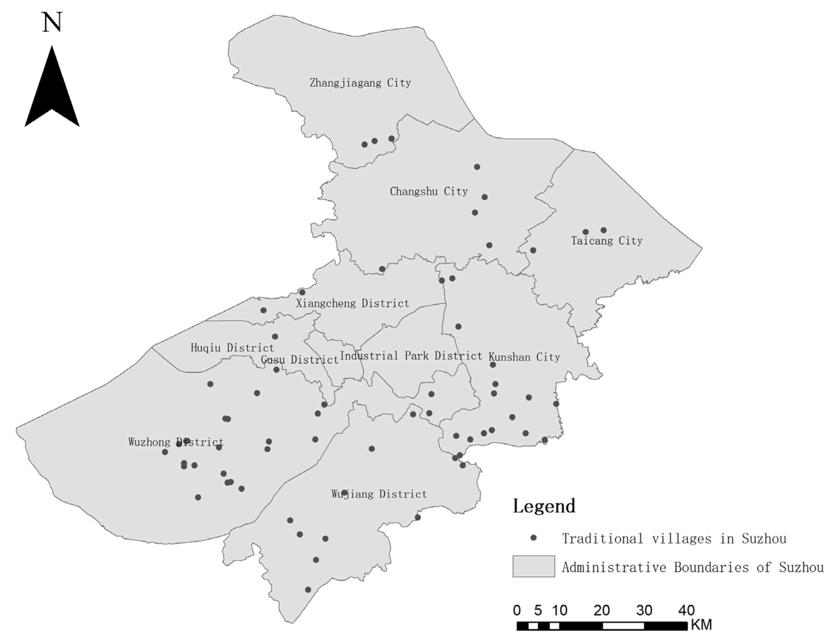
2.1. Study Area: Southern Jiangsu Province
2.2. Data Sources
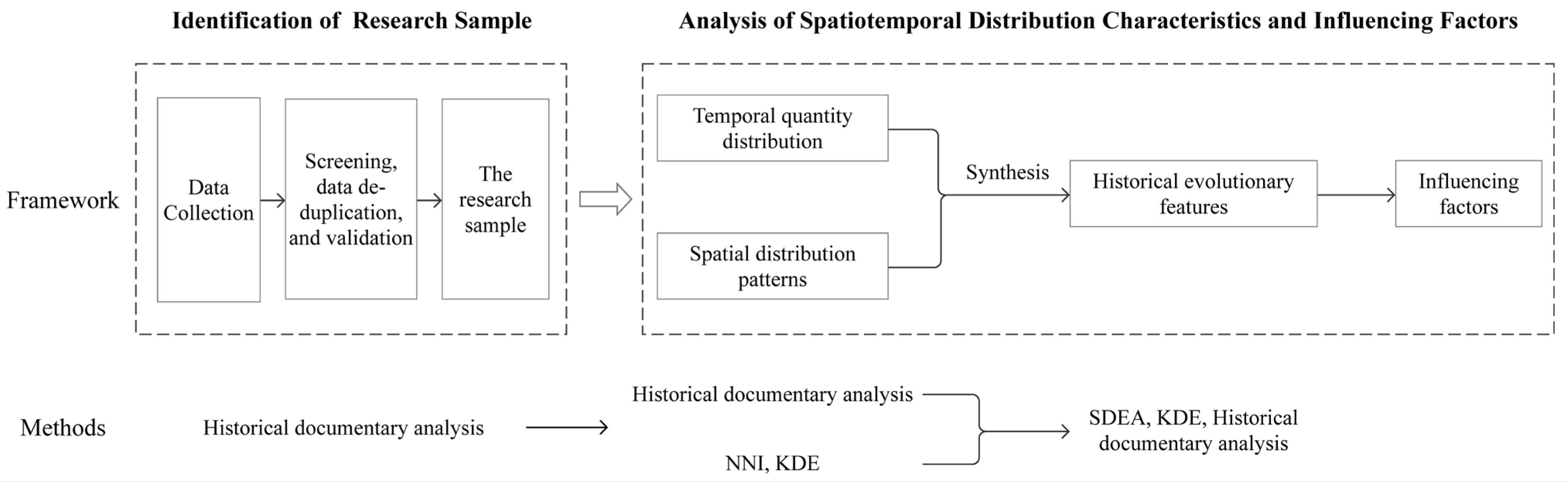
2.3. Methods
2.3.1. Historical Document Analysis
2.3.2. Standard Deviation Ellipse Analysis (SDEA)
2.3.3. Nearest Neighbor Index Analysis
2.3.4. Kernel Density Estimation (KDE) Analysis
3. Results
3.1. Spatial and Temporal Distribution and Evolutionary Characteristics of Traditional Villages in Southern Jiangsu Province
3.1.1. Formation-Time Distribution Characteristics of the Traditional Villages
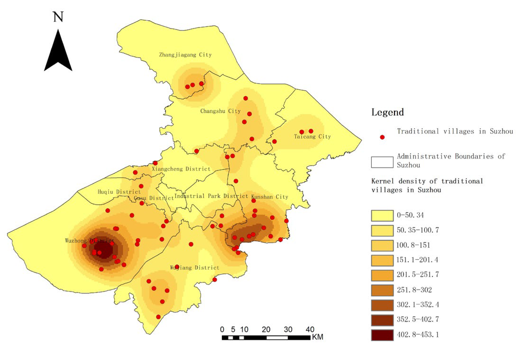
3.1.2. Spatial Distribution Pattern of Traditional Villages
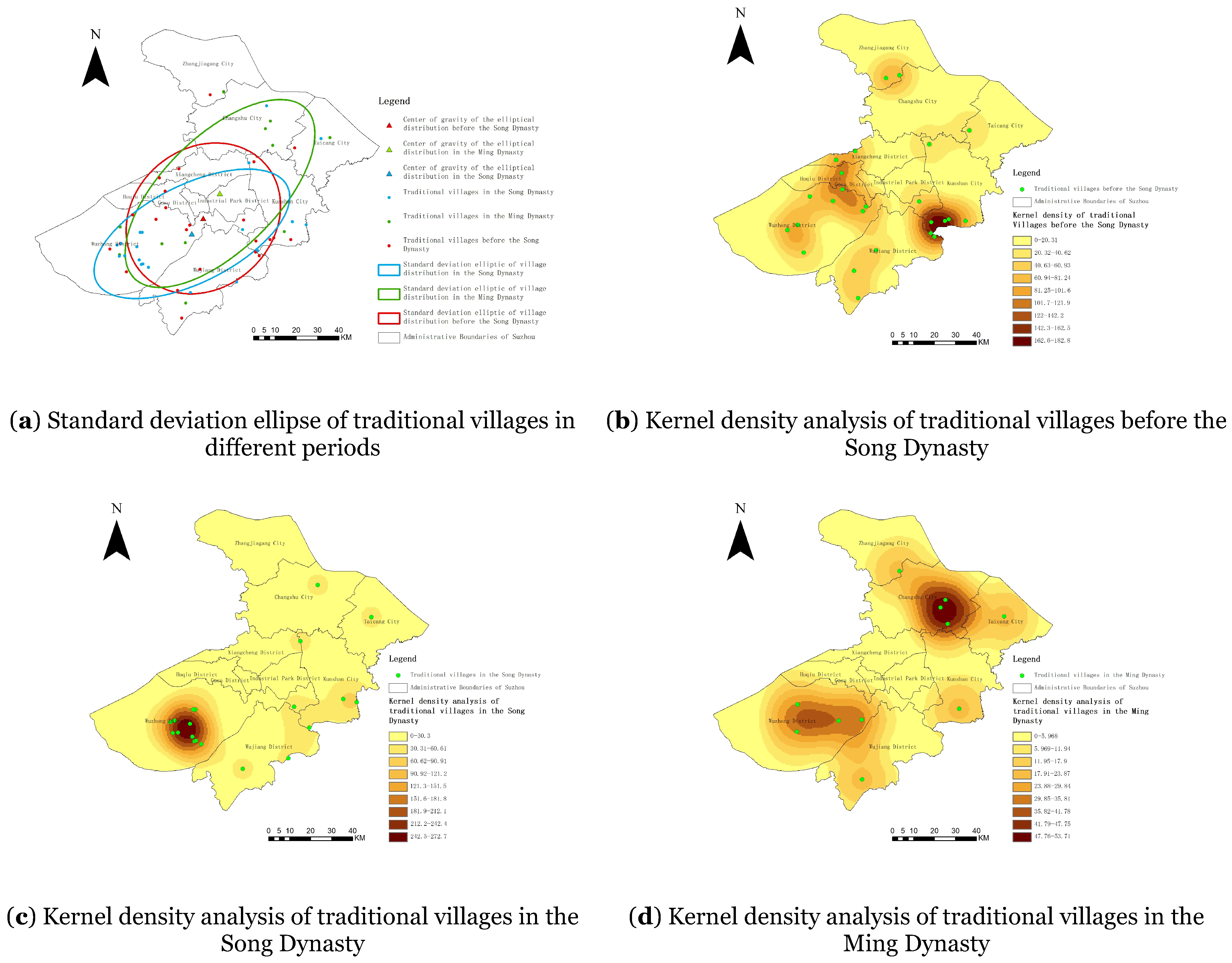
3.1.3. Characterization of Spatiotemporal Evolution of Traditional Villages
3.2. The Influence of the Natural Environment on the Spatial and Temporal Distribution of Traditional Villages in Southern Jiangsu Province
3.2.1. Water System
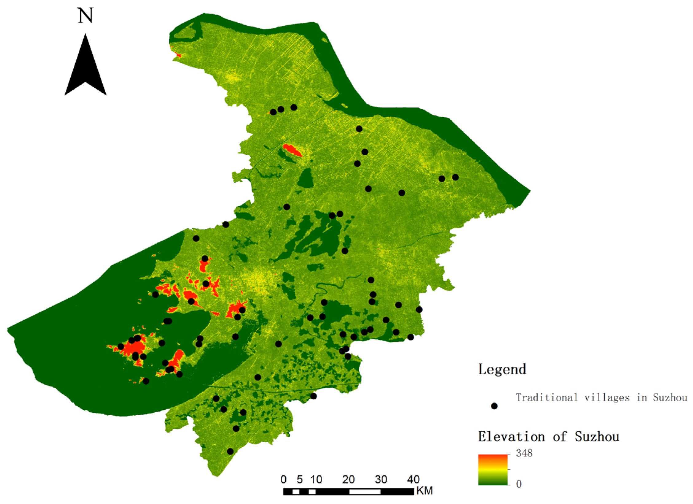
3.2.2. Topographic Features
3.3. The Influence of the Socio-Economic Environment on the Spatial and Temporal Distribution of Traditional Villages in Southern Jiangsu Province
3.3.1. Population Size
3.3.2. Transportation Conditions
3.3.3. Economic Development Level
4. Discussion
4.1. Implications for Policymaking and Rural Revitalization
- (1)
- Water system protection: Strengthen efforts to protect water systems to maintain the integrity of both the ecological environment and village patterns.
- (2)
- Infrastructure and policy incentives: Upgrade village infrastructure and implement policy measures that encourage residents to return, thereby steadily increasing the population and enhancing village vitality.
- (3)
- Balance between transportation facilities and conservation: Improve road transportation infrastructure to enhance village accessibility while striving to balance conservation and development.
- (4)
- Industrial diversification: Encourage industrial diversification, particularly in the primary and tertiary sectors, to elevate the economic statuses of villages and foster coordinated growth in line with socio-economic development.
4.2. Limitations of This Study
5. Conclusions
- (1)
- Characteristics of spatial distribution: The traditional villages in Southern Jiangsu exhibit a cohesive spatial distribution, with higher village densities in the southern and marginal areas and fewer villages in the northern and central regions. A significant tendency toward village clustering can notably be observed in the southwestern part of the Taihu Lake basin and the southeastern part of the Dianshan Lake basin, reflecting the traditional settlement pattern of residing in proximity to water sources.
- (2)
- Socio-economic development level: Analysis at the district and county levels revealed that the traditional villages are predominantly concentrated in areas with lower socio-economic development, which is inversely related to the number of the traditional villages. This highlights the complex relationship between economic development and the preservation of traditional villages.
- (3)
- Historical distribution: The temporal analysis indicates that the formation of traditional villages in Southern Jiangsu spanned several dynasties, with the Song Dynasty serving as the peak period for village establishment, significantly influencing the current spatial distribution of these settlements.
- (4)
- Influencing factors: Natural conditions, social environments, and economic statuses are the primary factors influencing the spatial and temporal distribution of the traditional villages in Southern Jiangsu.
Author Contributions
Funding
Institutional Review Board Statement
Informed Consent Statement
Data Availability Statement
Conflicts of Interest
References
- Li, Y.; Chen, T.; Wang, J.; Wang, D. Temporal-spatial distribution and formation of historic and cultural villages in China. Geogr. Res. 2013, 32, 1477–1485. [Google Scholar]
- Ministry of Housing and Urban-Rural Development. Urban and Rural Construction Statistical Yearbook. 2023. Available online: https://www.mohurd.gov.cn (accessed on 8 September 2024).
- Li, P. Exploring the logic of “the end of villages” from “villages in the city”. Beijing Daily, 25 September 2006; p. 20. [Google Scholar]
- Xue, Q.; Huang, Y.; Deng, Q.; Ning, L. Research on the dynamic evaluation and adaptive protective development of traditional villages: A case study based on three typical traditional villages in the Loess Hill and Gully Region of Longzhong. South Archit. 2024, 4, 54–63. [Google Scholar]
- Ministry of Finance of the People’s Republic of China. Notice on Organizing the Application for the 2020 Demonstration City for the Concentrated Protection and Utilization of Traditional Villages. Available online: https://jjs.mof.gov.cn/tongzhigonggao/202005/t202005273521058.htm (accessed on 8 September 2024).
- Liu, Z. Research on the conservation and development strategy of ancient village space under the construction of excellent traditional culture. China Famous Cities 2022, 36, 89–94. [Google Scholar]
- Wang, S.; Sun, J. Construction and empirical research on the evaluation system of sustainable development of Chinese traditional villages. Acta Geogr. Sin. 2021, 76, 921–938. [Google Scholar]
- Hu, J.; Teng, Y.; Zheng, W.; Tian, M. Spatial distribution and influential factors of traditional villages in the Dong inhabited areas of Hunan, Guangxi and Guizhou. J. Guilin Univ. Technol. 2023, 43, 520–526. [Google Scholar]
- Li, J.; Chu, J.; Ye, J.; Liu, H.; Zhang, J. Spatial evolutionary characteristics and driving mechanism of traditional villages in ancient Huizhou. Econ. Geogr. 2018, 38, 153–165. [Google Scholar]
- Li, J.; Wang, X.; Li, X. Spatial distribution characteristics and influencing factors of Chinese traditional villages. Econ. Geogr. 2020, 40, 143–153. [Google Scholar]
- Tang, Y.; Wu, J.; Zhang, Y.; Deng, L.; Shi, C. Spatial distribution characteristics and influencing factors of the traditional villages in northern Shaanxi. Soil Water Conserv. Res. 2023, 30, 396–405. [Google Scholar]
- Wang, P.; Zhang, J.; Sun, F.; Cao, S.; Kan, Y.; Wang, C.; Xu, D. Spatial distribution and the impact mechanism of traditional villages in Southwest China. Econ. Geogr. 2021, 41, 204–213. [Google Scholar]
- Xia, Y.; Huang, X.; Kang, C.; Xu, X. Spatial differentiation of accessibility characteristics and influencing factors of traditional villages in Shaanxi Province. J. Northwest Univ. (Nat. Sci. Ed.) 2024, 54, 288–299. [Google Scholar] [CrossRef]
- Zhao, R.; Shen, Y. Research on spatial distribution and influence factors of Chinese Historic and Cultural Towns. J. Cap. Norm. Univ. (Nat. Sci. Ed.) 2019, 40, 83–89. [Google Scholar]
- Sun, J.; Huang, K.; Wang, X. Tourism development and rural revitalization based on local experiences: Logic and cases. J. Tour. 2020, 35, 39–49. [Google Scholar]
- Yan, J.; Zhao, Y.; Hao, L.; Guo, Y. Evaluation of intangible cultural heritage tourism utilization potential and type area division in China based on multi-source data. Geogr. Res. 2023, 42, 3294–3312. [Google Scholar]
- Gao, W.; Xiao, D.; Zhao, Y.; Tao, J.; Zhuo, X.L. Study on the cultural landscape characteristics and influencing factors of traditional villages and dwellings in central Yunnan. J. Archit. 2023, S1, 194–200. [Google Scholar]
- Liu, C.; Xu, M.; Liu, P.; Zeng, F. Cultural landscape protection compensation model of traditional villages and its application in Xiangxi. Acta Geogr. Sin. 2020, 75, 382–397. [Google Scholar]
- Fang, Y.; Lu, H.; Huang, Z.; Zhu, Z. Spatiotemporal distribution of Chinese traditional villages and its influencing factors. Econ. Geogr. 2023, 43, 187–196. [Google Scholar]
- Zhang, X.; Gu, T.; Wei, H. The spatial distribution pattern and influencing factors of intangible cultural heritage and traditional villages in Yunnan, Guizhou and Sichuan provinces. Resour. Dev. Mark. 2024, 40, 33–41. [Google Scholar]
- Bański, J.; Wesołowska, M. Transformations in housing construction in rural areas of Poland’s Lublin region—Influence on the spatial settlement structure and landscape aesthetics. Landsc. Urban Plan. 2009, 94, 116–126. [Google Scholar] [CrossRef]
- Lazzari, M.; Danese, M.; Masini, N. A new GIS-based integrated approach to analyse the anthropic-geomorphological risk and recover the vernacular architecture. J. Cult. Herit. 2009, 10, e104–e111. [Google Scholar] [CrossRef]
- Philokyprou, M.; Michael, A. Environmental sustainability in the conservation of vernacular architecture. The case of rural and urban traditional settlements in Cyprus. Int. J. Archit. Herit. 2020, 15, 1741–1763. [Google Scholar] [CrossRef]
- Lim, T.S.Y.; Hassan, N.; Ghaffarianhoseini, A.; Daud, M.N. The relationship between satisfaction towards neighbourhood facilities and social trust in urban villages in Kuala Lumpur. Cities 2017, 67, 85–94. [Google Scholar] [CrossRef]
- Jimura, T. The impact of world heritage site designation on local communities—A case study of Ogimachi, Shirakawa-mura, Japan. Tour. Manag. 2010, 32, 288–296. [Google Scholar] [CrossRef]
- Suzhou Local Chronicles Compilation Committee. Suzhou Municipal Chronicles. 2008. Available online: http://dfzb.suzhou.gov.cn/dfzk/database_books.aspx?cid=604 (accessed on 3 September 2009).
- Ministry of Housing and Urban-Rural Development. The List of Traditional Chinese Villages. Available online: https://www.chuantongcunluo.com (accessed on 6 June 2025).
- National Cultural Heritage Administration. The List of Chinese Historical and Cultural Villages. Available online: http://www.ncha.gov.cn/ (accessed on 6 June 2025).
- Jiangsu Provincial Department of Housing and Urban-Rural Development. The List of Provincial-Level Traditional Villages. Available online: https://jsszfhcxjst.jiangsu.gov.cn (accessed on 6 June 2025).
- Zuo, X.; Zhou, Y.; Li, Q.; Wang, L. Analysis of spatial and temporal changes and trajectory characteristics of land use pattern in the southwest Hubei. J. Soil Water Conserv. 2022, 36, 161–169. [Google Scholar]
- Kang, J.; Zhang, J.; Hu, H.; Zhou, J.; Xiong, J. Analysis of the spatial distribution characteristics of Chinese traditional villages. Prog. Geogr. Sci. 2016, 35, 839–850. [Google Scholar]
- Cheng, M. Economic History of Northern China; People’s Publishing House: Beijing, China, 2004; pp. 693–694. [Google Scholar]
- Chen, Y. Urban Space: Form, Type and Meaning: Research on the Structural Evolution of the Ancient City of Suzhou; Southeast University Press: Nanjing, China, 2006; p. 30. [Google Scholar]
- Liang, B.; Xiao, D.; Tao, J.; Ji, J.; Zhuo, X.; Huang, Y. Spatio-Temporal distribution and evolution of Hakka villages in Ganzhou. Econ. Geogr. 2018, 38, 196–203. [Google Scholar]
- Lu, S.; Zhang, X.; Zhang, Y. Spatial-temporal distribution and controlling factors of traditional villages in Huizhou region. Geogr. Sci. 2018, 38, 1690–1698. [Google Scholar]


| District Name | Number of Traditional Villages | Population Density (Persons/km2) | GDP per Capita (Million CNY) | Proportion of Primary Industry (%) | Road Density (km/km2) | Urbanization Rate (%) |
|---|---|---|---|---|---|---|
| Wuzhong | 25 | 630.82 | 11.30 | 1.11 | 1.38 | 77.43 |
| Kunshan | 15 | 2281.46 | 23.56 | 0.62 | 5.19 | 79.39 |
| Wujiang | 11 | 1266.00 | 14.89 | 1.63 | 2.69 | 75.82 |
| Changshu | 5 | 1326.00 | 16.39 | 1.49 | 3.38 | 74.04 |
| Zhangjiagang | 4 | 1467.07 | 22.81 | 0.93 | 3.75 | 74.38 |
| Taicang | 3 | 1041.57 | 19.60 | 1.46 | 2.91 | 71.03 |
| Xiangcheng | 3 | 1842.40 | 12.24 | 0.75 | 4.47 | 94.27 |
| Huqiu | 1 | 2539.04 | 20.93 | 0.07 | 4.29 | 91.97 |
| Gusu | 0 | 11153.20 | 9.81 | 0.00 | 12.21 | 100 |
| Industrial park | 0 | 4138.72 | 30.56 | 0.02 | 9.82 | 100 |
Disclaimer/Publisher’s Note: The statements, opinions and data contained in all publications are solely those of the individual author(s) and contributor(s) and not of MDPI and/or the editor(s). MDPI and/or the editor(s) disclaim responsibility for any injury to people or property resulting from any ideas, methods, instructions or products referred to in the content. |
© 2025 by the authors. Licensee MDPI, Basel, Switzerland. This article is an open access article distributed under the terms and conditions of the Creative Commons Attribution (CC BY) license (https://creativecommons.org/licenses/by/4.0/).
Share and Cite
Liu, Z.; Wang, Q.; Chen, J. Spatiotemporal Analysis of Traditional Villages in Southern Jiangsu Based on GIS and Historical Data. Architecture 2025, 5, 44. https://doi.org/10.3390/architecture5030044
Liu Z, Wang Q, Chen J. Spatiotemporal Analysis of Traditional Villages in Southern Jiangsu Based on GIS and Historical Data. Architecture. 2025; 5(3):44. https://doi.org/10.3390/architecture5030044
Chicago/Turabian StyleLiu, Zhihong, Qingyu Wang, and Jilong Chen. 2025. "Spatiotemporal Analysis of Traditional Villages in Southern Jiangsu Based on GIS and Historical Data" Architecture 5, no. 3: 44. https://doi.org/10.3390/architecture5030044
APA StyleLiu, Z., Wang, Q., & Chen, J. (2025). Spatiotemporal Analysis of Traditional Villages in Southern Jiangsu Based on GIS and Historical Data. Architecture, 5(3), 44. https://doi.org/10.3390/architecture5030044