

Enhancing Route Optimization in Road Transport Systems Through Machine Learning: A Case Study of the Dakhla-Paris Corridor

 , , , ,
Abstract
1. Introduction
1.1. Challenges in Optimizing Transport Routes
1.2. Artificial Intelligence in Route Optimization
1.3. Objective of Our Study
2. Related Works
2.1. AI Applications in Transportation
2.2. Real-Time Route Optimization
2.3. Urban Mobility Trends
2.4. Dynamic Route Optimization Strategies
2.5. Comprehensive AI Integration in Transport
2.6. Multi-Objective Optimization Using Evolutionary Algorithms
2.7. Traffic Prediction and Management
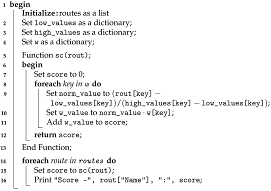
3. Proposed Approach
3.1. Data Preprocessing
- Data Collection: First of all, the data must be assembled on possible paths with constraints in a consolidated form.
- Data Wrangling: Making the data usable by machine learning algorithms by extracting features through data cleaning, breakdown of data, and data scaling, as well as data shaping and transformation.
- Duration (h): Total journey time, obtained by dividing the distance by the average speed expected on each type of road (freeway, trunk road, etc.).
- Mileage (km): The distance between the departure and destination points. Route calculation services such as Google Maps or OpenStreetMap use this information for each route.
- % Accidents: Average percentage of accidents on the route, obtained by analyzing local road safety statistics for each road segment crossed.
- % Infractions: Rate of driving infractions on the route. It is obtained from police reports and traffic control statistics, especially on high-risk roads.
- Road Type: Road category (freeway, trunk road, etc.), which is determined by the type of each route segment (A6, N4, etc.).
- Weather: Average weather conditions during the trip are based on seasonal climate databases for the time of year of the journey.
- Cost (EUR): Total estimated trip cost (fuel, tolls, etc.). The sum of fuel and toll costs.
- Fuel (L): Volume of fuel required for the trip.
- Toll (EUR): The total cost of tolls for the route. Toll cost calculators, such as those offered by ViaMichelin, can provide this information.
- Interest: Route category (logistics, emergency, etc.). Choice according to the need for the journey (goods transport, urgent personal journeys, etc.).
- Network Coverage (%): The quality of network coverage along the route. This is an estimate made from coverage maps provided by operators.
- Intelligent Route: The presence of intelligent road technologies (adaptive signaling, etc.). Local or regional road infrastructures provide this information.
- Slope (%): Average inclination of the road, calculated by analyzing the altitudes at the start and end points or by consulting topographical maps.
- Traffic Density: The expected level of traffic. It is obtained via real-time traffic applications (Waze, Google Traffic) or average density data.
- Charging Points: Number of electric charging stations along the route.
- Service Stations: Number of service stations along the route.
- Landscape: The dominant landscape (mountain, desert, coastal).
- Road Durability: Local infrastructure management data determine road durability (frequency of repairs, pavement quality).
- Road Safety: A general assessment of the route’s safety (presence of speed cameras and risk zones) is obtained via road safety reports.
- Toll Waiting Time (min): The average waiting time at toll booths, estimated from local traffic statistics.
- Average Temperature (°C): The average temperature along the route, obtained from seasonal climate data for the regions crossed.
- Truck Accessibility: Indicates whether the route is accessible to trucks. Road restrictions are available from local authorities for this.
- Tunnels/Bridges: Number of tunnels and bridges on the route.
- Escape Options: There will be alternative routes in the event of closure.
- emissions (kg): Estimated emissions.
- Speed Limits (km/h): The maximum speed allowed on each segment by local legislation for each type of road.
- Driving Comfort: Level of comfort for the driver (road conditions, curves, etc.).
- Peak Hour: Potential peak hours along the route.
- User Choice %: This indicates the route’s popularity among users. It is obtained by choice analysis or a user survey.
- Optimized: Indicator of the optimization of a transport route, equal to 0 or 1. This indicator is often based on the mathematically calculated score. If the score exceeds 0.7, then the route is optimized.
3.2. Mathematical Modeling
- : The normalized value.
- : The original feature value.
- : The minimum value of the feature.
- : The maximum value of the feature.
3.2.1. Identification of Features
3.2.2. Value Normalization
3.2.3. Definition of Weights
3.2.4. Calculating the Optimization Score
| Algorithm 1: Calculating the score for each route |
 |
3.3. Algorithms Selection
- Support Vector Machines (SVM): Rationale: SVMs are renowned for their robustness in classification challenges, especially in high-dimensional spaces. Their capability to model non-linear decision boundaries using kernel tricks makes them invaluable for route optimization, where the relationship between input features (like traffic and road conditions) and outcomes (optimal routes) may be highly non-linear.Strengths: Effective in high-dimensional spaces, SVMs are less prone to overfitting, particularly in cases where the number of dimensions exceeds the number of samples.Limitations: They require a good choice of kernel and regularization parameters, which can be computationally intensive to tune. Additionally, SVMs do not directly provide probability estimates, which are crucial for some decision-making processes.
- Naive Bayes: Rationale: Naive Bayes’ simplicity and speed make it an excellent choice for real-time route optimization. Given its strong feature independence assumption, it performs well on large datasets with many features describing each route’s conditions.Strengths: It is speedy for training and prediction, making it suitable for real-time analysis applications.Limitations: Its assumption of independent predictors can be a drawback in scenarios where the predictors are interdependent, such as traffic conditions that affect road safety.
- Neural Networks: Rationale: Neural networks are at the forefront of handling complex patterns and interactions between variables. They are capable of learning almost any non-linear function, which makes them particularly adept at adapting to dynamic environments like those encountered in route optimization.Strengths: They are highly flexible and can be trained to understand complex relationships and interactions between input features.Limitations: Neural networks require substantial data to train effectively and can be opaque regarding interpretability (often called “black boxes”).
- Logistic Regression: Rationale: Despite its simplicity, logistic regression can be a robust baseline for binary classification problems. In the context of route optimization, it can efficiently handle binary decisions, such as route selection between two alternatives.Strengths: It is transparent, easy to implement, and provides the benefit of understanding the influence of each feature.Limitations: It is constrained to linear decision boundaries, which can limit its effectiveness in more complex scenarios.
- Gradient Boosting: Rationale: Gradient boosting is a potent ensemble technique that builds models sequentially to correct the predecessors’ errors, thereby improving accuracy. Its applicability in non-linear and complex datasets where there are multifaceted relationships between variables make it an excellent choice for optimizing routes.Strengths: It often provides predictive accuracy that cannot be trumped by other algorithms and handles a mix of continuous and categorical data well.Limitations: If not tuned properly, it can be prone to overfitting and may require careful setting of parameters and stopping criteria to prevent computation inefficiencies.Each algorithm was selected for its technical merits and its proven applicability in transportation and logistics scenarios, ensuring that our approach is grounded in theoretical and practical considerations. By leveraging the unique strengths of these diverse algorithms, we aim to develop a robust predictive model that can dynamically adapt to varying conditions and optimize routes with high precision.
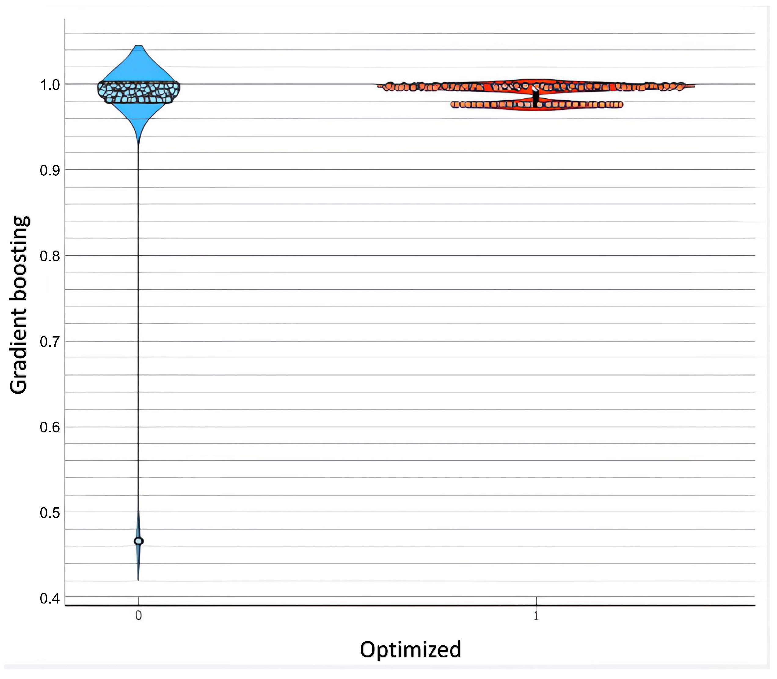
3.4. Performance Evaluation
- Test and score, using metrics such as precision, recall, F1-score, AUC, etc.
- A box plot is used to compare the distribution of performance scores between different algorithms.
- Matrix confusion through correct and incorrect predictions.
4. Results and Discussion
4.1. Results Analysis
4.2. Discussion
4.3. Limitations
4.4. Comparison with Other Approaches
- “X” indicates the use of a standard number of features and a typical dataset size used in the related works.
- “XXX” in our work refers to a significant enhancement—we expanded the number of features and the dataset size by a factor of 3, aiming to improve model generalization and accuracy.
5. Conclusions and Future Work
Author Contributions
Funding
Institutional Review Board Statement
Informed Consent Statement
Data Availability Statement
Conflicts of Interest
Abbreviations
| ANNs | Artificial neural networks |
| AI | Artificial intelligence |
| CC BY | Creative Commons Attribution |
| ML | Machine learning |
| RF | Random forest |
| SVM | Support vector machine |
| SVR | Support vector regression |
| DL | Deep learning |
| NV | Naive Bayes |
| CA | Classification Accuracy Technology |
References
- Abduljabbar, R.; Dia, H.; Liyanage, S.; Asadi Bagloee, S. Applications of Artificial Intelligence in Transport: An Overview. Sustainability 2019, 11, 189. [Google Scholar] [CrossRef]
- Drozdov, A. Real-Time Route Optimization with AI Solutions. 2024. Available online: https://yellow.systems/blog/real-time-route-optimization-with-ai (accessed on 2 April 2025).
- Schrank, D.; Eisele, B.; Lomax, T. The 2021 Urban Mobility Report; Technical Report; Texas A&M Transportation Institute: College Station, TX, USA, 2021. [Google Scholar]
- World Health Organization. Global Status Report on Road Safety 2021; WHO: Geneva, Switzerland, 2021. [Google Scholar]
- Lin, H.; Tang, C. Analysis and optimization of urban public transport lines based on multiobjective adaptive particle swarm optimization. IEEE Trans. Intell. Transp. Syst. 2022, 23, 16786–16798. [Google Scholar] [CrossRef]
- Jiang, S.; Zhang, Y.; Liu, R.; Jafari, M.; Kharbeche, M. Data-driven optimization for dynamic shortest path problem considering traffic safety. IEEE Trans. Intell. Transp. Syst. 2022, 23, 18237–18252. [Google Scholar]
- Jain, N.; Husain, S.O.; Goyal, S.; Hariharasudhan, S.; Victor, M.; Manjula. Predictive Analytics for Network Traffic Management. In Proceedings of the 2024 IEEE International Conference on Communication, Computing and Signal Processing (IICCCS), Asansol, India, 19–20 September 2024; pp. 1–6. [Google Scholar] [CrossRef]
- Metrix, S. Optimisation des Transports: Technologies émergentes. 2023. Available online: https://solutionsmetrix.com/fr/article/optimisation-des-transports-grace-aux-nouvelles-technologies/ (accessed on 2 April 2025).
- Bharadiya, J.P. Artificial intelligence in transportation systems a critical review. Am. J. Comput. Eng. 2023, 6, 35–45. [Google Scholar] [CrossRef]
- Akhtar, M.; Moridpour, S. A review of traffic congestion prediction using artificial intelligence. J. Adv. Transp. 2021, 2021, 8878011. [Google Scholar] [CrossRef]
- Eriksen, B.; Jensen, M. Machine Learning for Real-Time Traffic Prediction and Route Planning. Procedia Comput. Sci. 2020, 176, 2760–2769. [Google Scholar] [CrossRef]
- Subash, R.; Prathaban, B.P.; Ganeshkumar, N.; Gopinathan, S. Enhanced Route Optimization: Incorporating Road Safety Factors for Optimal Path Selection. In Proceedings of the 2024 International Conference on Power, Energy, Control and Transmission Systems (ICPECTS), Online, 8–9 December 2024; IEEE: Piscataway, NJ, USA, 2024; pp. 1–4. [Google Scholar]
- Jagatheesaperumal, S.K.; Bibri, S.E.; Huang, J.; Rajapandian, J.; Parthiban, B. Artificial intelligence of things for smart cities: Advanced solutions for enhancing transportation safety. Comput. Urban Sci. 2024, 4, 10. [Google Scholar] [CrossRef]
- Lukic Vujadinovic, V.; Damnjanovic, A.; Cakic, A.; Petkovic, D.R.; Prelevic, M.; Pantovic, V.; Stojanovic, M.; Vidojevic, D.; Vranjes, D.; Bodolo, I. Ai-driven approach for enhancing sustainability in urban public transportation. Sustainability 2024, 16, 7763. [Google Scholar] [CrossRef]
- Mahmassani, H.; Zhou, X. Dynamic Network Traffic Assignment and Simulation Methodology for Advanced Transportation Systems; Elsevier: Amsterdam, The Netherlands, 2017. [Google Scholar]
- Choudhury, R.A.; Singh, M.; Kumar, R.; Devi, R.; Sharma, S.; Singh, J.; Kumar, A.; Abbas, M. A Critical Review on the Role of Artificial Intelligence in Transforming the Transportation Sector. Arch. Comput. Methods Eng. 2025, 1–18. [Google Scholar] [CrossRef]
- Adeyinka, K.I.; Adeyinka, T.I. Real-Time Traffic Management Using Graph Models. In Neural Networks and Graph Models for Traffic and Energy Systems; IGI Global Scientific Publishing: New York, NY, USA, 2025; pp. 231–258. [Google Scholar]
- Vastag, T.; Lőrincz, F. A Systematic Review of Urban Mobility and Preliminary Research of Transportation Trends in West Hungary. Eng. Proc. 2024, 79, 7. [Google Scholar] [CrossRef]
- Akopov, A.S.; Beklaryan, L.A. Evolutionary Synthesis of High-Capacity Reconfigurable Multilayer Road Networks Using a Multiagent Hybrid Clustering-Assisted Genetic Algorithm. IEEE Access 2025, 13, 53448–53474. [Google Scholar] [CrossRef]
- Agrawal, A.K.; Yadav, S.; Gupta, A.A.; Pandey, S. A genetic algorithm model for optimizing vehicle routing problems with perishable products under time-window and quality requirements. Decis. Anal. J. 2022, 5, 100139. [Google Scholar] [CrossRef]


| Article | Objective | Result |
|---|---|---|
| [1] | Exploring AI applications in transportation to improve sustainability and efficiency. | Identification of various transport applications to improve sustainability and efficiency |
| [2] | Presenting AI-based real-time route optimization solutions. | Improving route efficiency and reducing costs with AI. |
| [3] | Analyzing trends and challenges in urban mobility, including the impact of traffic and congestion. | Detailed data on the impacts of urban congestion on mobility and recommendations for mitigation. |
| [6] | Presenting dynamic route optimization strategies based on data analysis. | Development of efficient route optimization strategies based on real-time data. |
| [7] | Using ML for improving traffic management through predictive traffic management. | High traffic condition prediction and route adjustment. |
| [11] | Examining the use of machine learning for real-time traffic prediction and route planning. | Accurate traffic prediction and improved real-time route planning. |
| [13] | A comprehensive review of the role of AI in enhancing transport safety and efficiency. | AI significantly improves transportation safety and efficiency. |
| [15] | Developing dynamic traffic assignment and simulation methodologies for advanced transportation systems. | Optimizing advanced transportation systems with practical applications. |
| Model | AUC | F1 | Prec | Recall | |
|---|---|---|---|---|---|
| Gradient Boosting | 0.642 | 0.867 | 0.836 | 0.807 | 0.867 |
| Logistic Regression | 0.840 | 0.867 | 0.881 | 0.904 | 0.867 |
| SVM | 0.728 | 0.900 | 0.853 | 0.810 | 0.900 |
| Naive Bayes | 0.630 | 0.933 | 0.918 | 0.938 | 0.933 |
| Neural Network | 0.741 | 0.933 | 0.918 | 0.938 | 0.933 |
Disclaimer/Publisher’s Note: The statements, opinions and data contained in all publications are solely those of the individual author(s) and contributor(s) and not of MDPI and/or the editor(s). MDPI and/or the editor(s) disclaim responsibility for any injury to people or property resulting from any ideas, methods, instructions or products referred to in the content. |
© 2025 by the authors. Licensee MDPI, Basel, Switzerland. This article is an open access article distributed under the terms and conditions of the Creative Commons Attribution (CC BY) license (https://creativecommons.org/licenses/by/4.0/).
Share and Cite
El Karkouri, N.; Hassine, L.; Ledmaoui, Y.; Chaibi, H.; Saadane, R.; Enneya, N.; El Aroussi, M. Enhancing Route Optimization in Road Transport Systems Through Machine Learning: A Case Study of the Dakhla-Paris Corridor. Future Transp. 2025, 5, 60. https://doi.org/10.3390/futuretransp5020060
El Karkouri N, Hassine L, Ledmaoui Y, Chaibi H, Saadane R, Enneya N, El Aroussi M. Enhancing Route Optimization in Road Transport Systems Through Machine Learning: A Case Study of the Dakhla-Paris Corridor. Future Transportation. 2025; 5(2):60. https://doi.org/10.3390/futuretransp5020060
Chicago/Turabian StyleEl Karkouri, Najib, Lahcen Hassine, Younes Ledmaoui, Hasna Chaibi, Rachid Saadane, Nourddine Enneya, and Mohamed El Aroussi. 2025. "Enhancing Route Optimization in Road Transport Systems Through Machine Learning: A Case Study of the Dakhla-Paris Corridor" Future Transportation 5, no. 2: 60. https://doi.org/10.3390/futuretransp5020060
APA StyleEl Karkouri, N., Hassine, L., Ledmaoui, Y., Chaibi, H., Saadane, R., Enneya, N., & El Aroussi, M. (2025). Enhancing Route Optimization in Road Transport Systems Through Machine Learning: A Case Study of the Dakhla-Paris Corridor. Future Transportation, 5(2), 60. https://doi.org/10.3390/futuretransp5020060