Assessing the Quality of GNSS Observations for Permanent Stations in Mexico (2020–2023)
Abstract
1. Introduction
2. Method
2.1. Data Used in the Analysis
2.2. Data Processing, Quality Assessment, and Parameter Estimation
- (1)
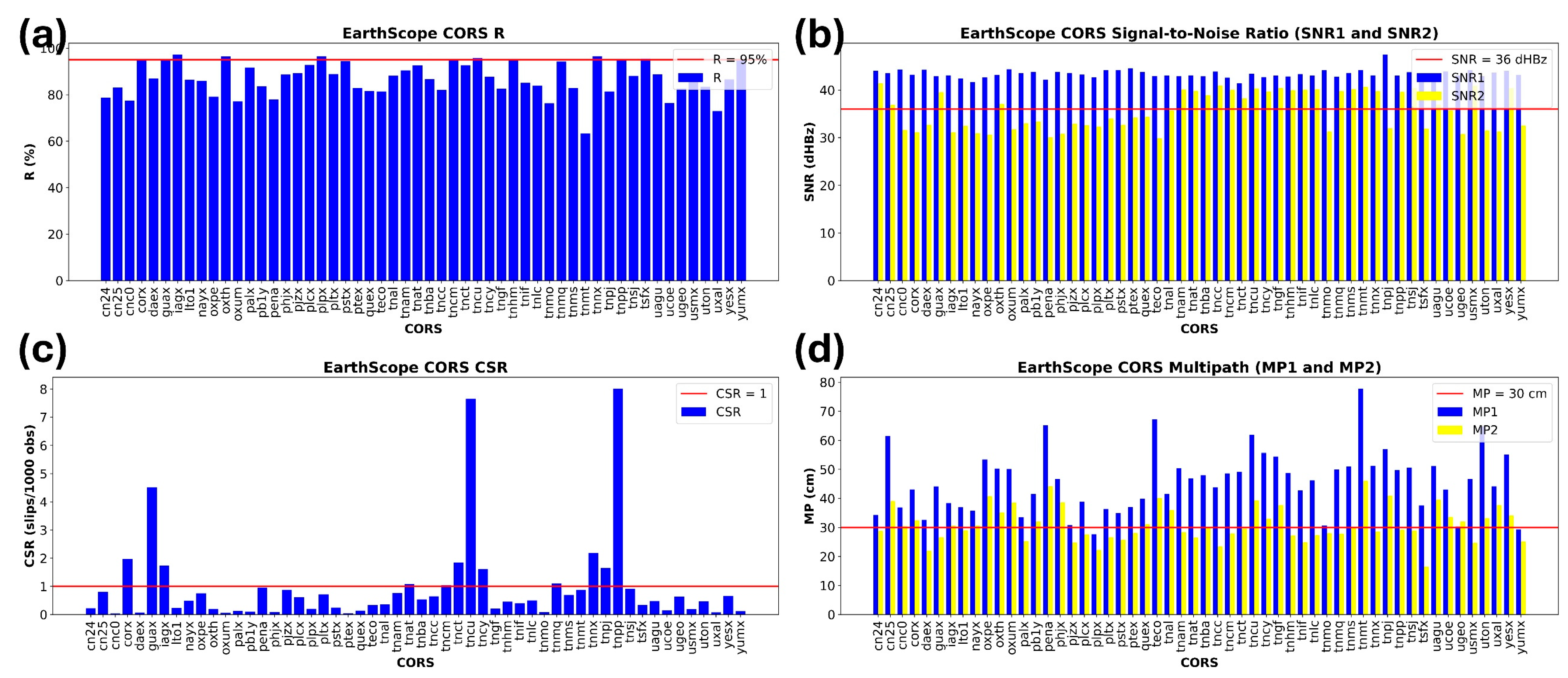
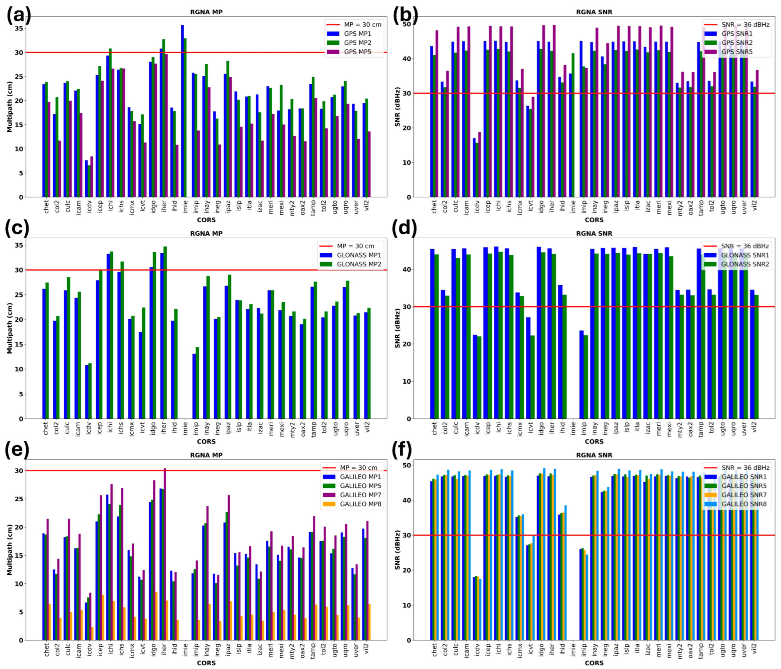
- Multipath Effect (MP): Computed as the RMS moving average from linear combinations of carrier phase and pseudorange observations, using 24 h RINEX files with a 30 s sampling rate interval. The recommended IGS threshold is ≤0.30 m for both L1 and L2 frequencies.
- (2)
- Data Utilization Ratio (R): Defined as the proportion of successfully recorded observations relative to the total possible observations, with the IGS recommended minimum of 95%.
- (3)
- Cycle Slips (CSR): Defined as discontinuities in carrier-phase observations caused by interruptions in Doppler counts. CSR was estimated following [32] using carrier-phase data, where the IGS threshold is <1 slip per 1000 observations.
- (4)
- Signal-to-Noise Ratio (SNR): Although not formally part of the IGS parameters, SNR was included following [32] as an additional measure of signal strength. Values above 40 dBHz were classified as strong signals, while values below 28 dBHz indicated weak signals.
3. Results
4. Discussion
5. Conclusions
Author Contributions
Funding
Data Availability Statement
Acknowledgments
Conflicts of Interest
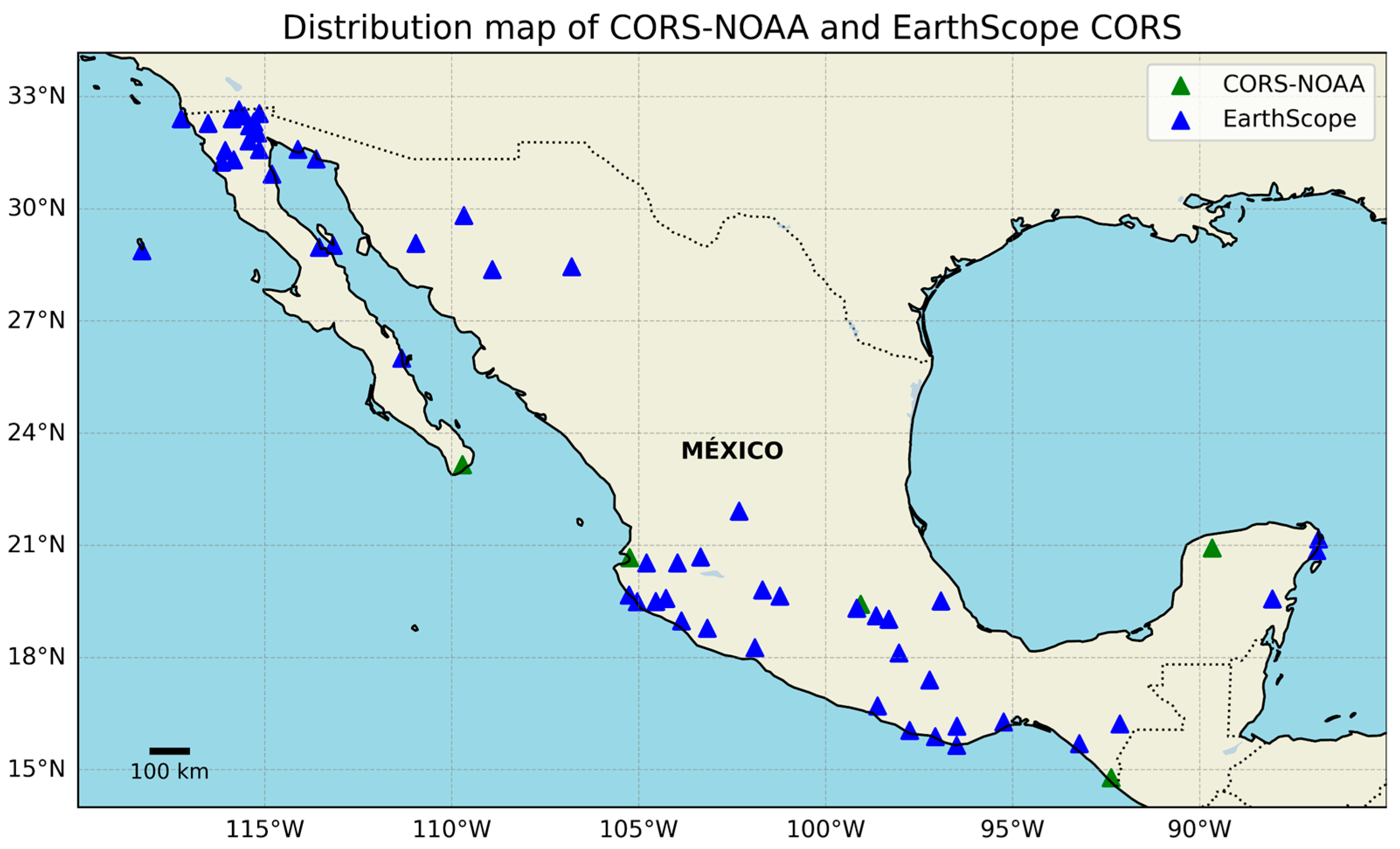
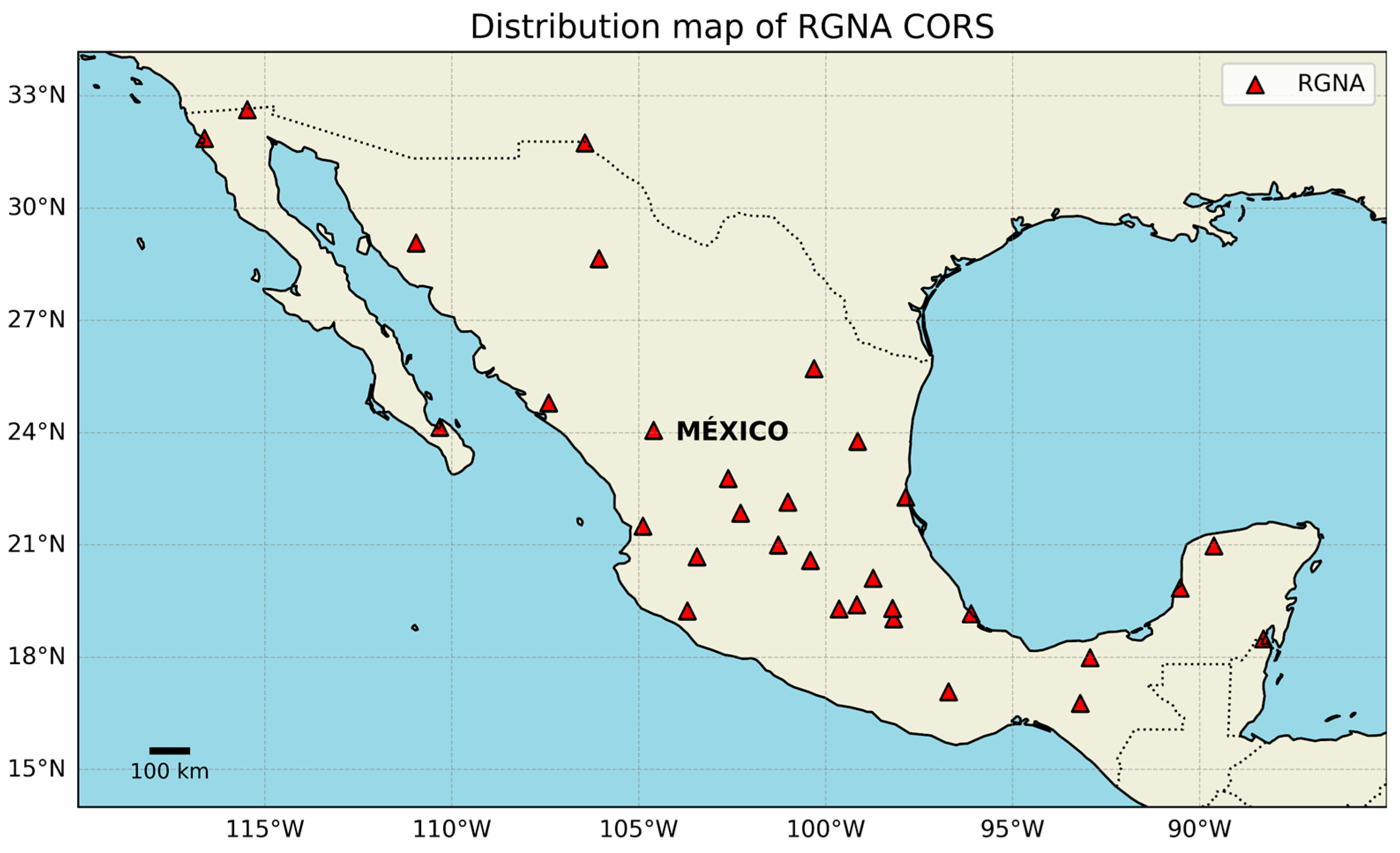
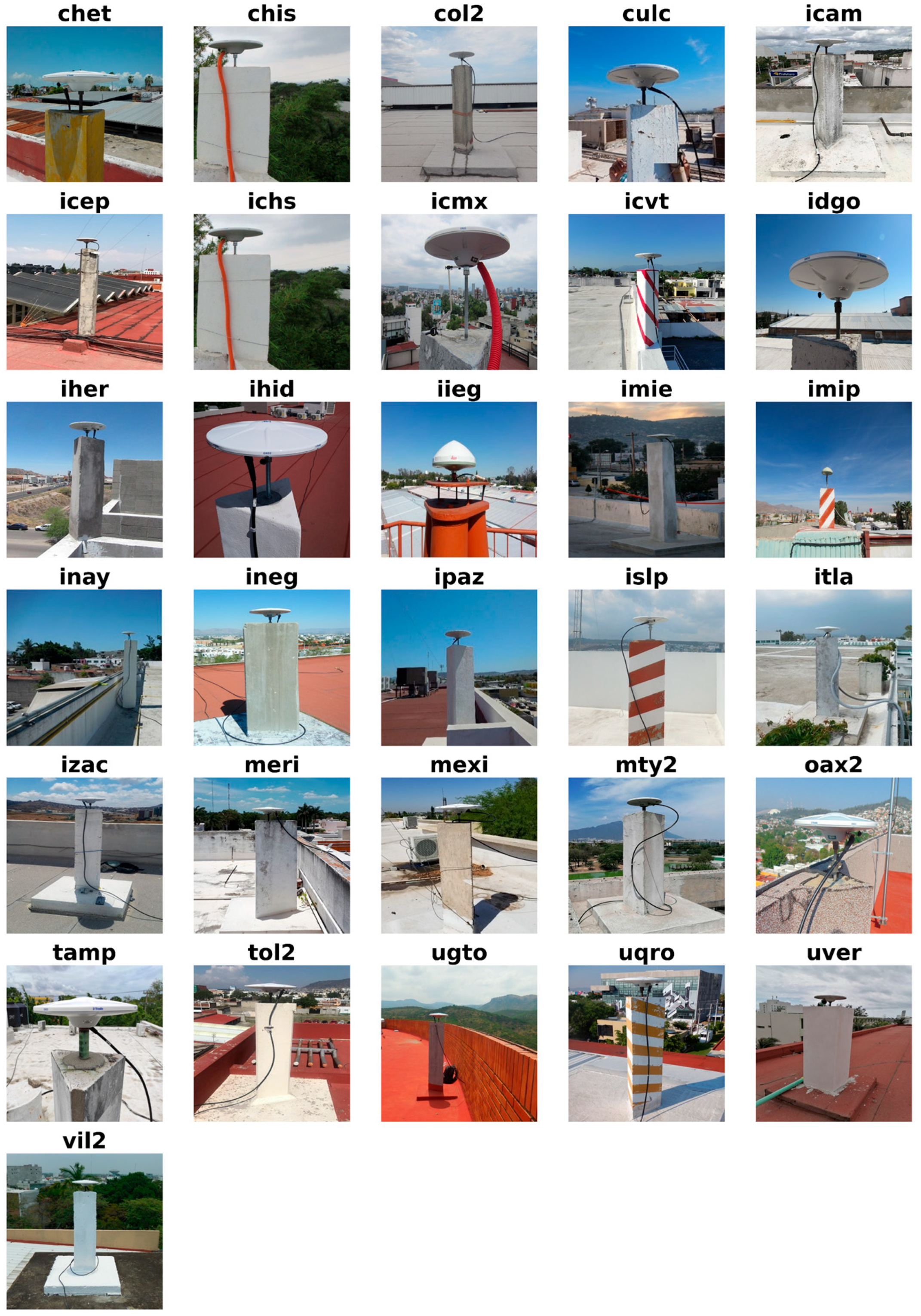
Appendix A. List of GNSS Stations Used in the Study
| Stations | Year | Total of RINEX | Receiver and Antenna | |||
|---|---|---|---|---|---|---|
| 2020 | 2021 | 2022 | 2023 | |||
| EarthScope Network | ||||||
| CN24 | 0 | 1 | 70 | 236 | 307 | TRIMBLE NETR9 and TRM59800 |
| CN25 | 249 | 365 | 365 | 365 | 1344 | TRIMBLE NETR9 and TRM59800 |
| CNC0 | 0 | 0 | 262 | 0 | 262 | TRIMBLE NETRS and TRM41249.00 |
| CORX | 365 | 365 | 365 | 244 | 1339 | TRIMBLE NETR8 and TRM59800.00 |
| DAEX | 365 | 365 | 365 | 365 | 1460 | TRIMBLE NETRS and TRM57971.00 |
| GUAX | 365 | 365 | 364 | 65 | 1159 | TRIMBLE NETR9 and TRM59800.00 |
| IAGX | 78 | 0 | 0 | 0 | 78 | TRIMBLE NETR8 and TRM59800.00 |
| LTO1 | 0 | 49 | 353 | 244 | 646 | TRIMBLE NETRS and TRM29659.00 |
| NAYX | 365 | 174 | 359 | 150 | 1048 | TRIMBLE NETRS and TRM59800.00 |
| OXPE | 279 | 0 | 165 | 0 | 444 | TRIMBLE NETRS and TRM41249.00 |
| OXTH | 58 | 0 | 0 | 0 | 58 | TRIMBLE NETR9 and TRM57971.00 |
| OXUM | 348 | 279 | 244 | 0 | 871 | TRIMBLE NETR9 and TRM57971.00 |
| PALX | 365 | 365 | 248 | 106 | 1084 | TRIMBLE NETRS and TRM59800.00 |
| PB1Y | 0 | 365 | 0 | 0 | 365 | TRIMBLE NETRS and TRM59800.00 |
| PENA | 363 | 361 | 360 | 208 | 1292 | TRIMBLE NETR9 and TRM59800.00 |
| PHJX | 176 | 0 | 0 | 0 | 176 | TRIMBLE NETR9 and TRM59800.00 |
| PJZX | 365 | 365 | 120 | 0 | 850 | TRIMBLE NETR9 and TRM59800.00 |
| PLCX | 363 | 365 | 326 | 136 | 1190 | TRIMBLE NETR9 and TRM59800.00 |
| PLPX | 365 | 363 | 280 | 0 | 1008 | TRIMBLE NETRS and TRM29659.00 |
| PLTX | 365 | 365 | 365 | 106 | 1201 | TRIMBLE NETRS and TRM29659.00 |
| PSTX | 53 | 0 | 0 | 0 | 53 | TRIMBLE NETRS and TRM59800.00 |
| PTEX | 365 | 365 | 365 | 365 | 1460 | TRIMBLE NETRS and TRM59800.00 |
| QUEX | 339 | 349 | 364 | 365 | 1417 | TRIMBLE NETRS and TRM29659.00 |
| TECO | 365 | 365 | 365 | 365 | 1460 | TRIMBLE NETR9 and TRM57971.00 |
| TNAL | 335 | 192 | 188 | 0 | 715 | TRIMBLE NETRS and TRM57971.00 |
| TNAM | 365 | 365 | 365 | 365 | 1460 | TRIMBLE NETR9 and TRM59800.00 |
| TNAT | 51 | 89 | 365 | 365 | 870 | TRIMBLE NETR9 and TRM59800.00 |
| TNBA | 77 | 0 | 0 | 0 | 77 | TRIMBLE NETR9 and TRM59800.00 |
| TNCC | 365 | 253 | 144 | 365 | 1127 | TRIMBLE NETR9 and TRM59800.00 |
| TNCM | 242 | 46 | 365 | 365 | 1018 | TRIMBLE NETR9 and TRM59800.00 |
| TNCT | 33 | 50 | 352 | 345 | 780 | TRIMBLE NETR9 and TRM57971.00 |
| TNCU | 365 | 365 | 365 | 365 | 1460 | TRIMBLE NETR9 and TRM59800.00 |
| TNCY | 109 | 32 | 365 | 365 | 871 | TRIMBLE NETR9 and TRM59800.00 |
| TNGF | 339 | 365 | 170 | 0 | 874 | TRIMBLE NETR9 and TRM59900.00 |
| TNHM | 365 | 84 | 365 | 365 | 1179 | TRIMBLE NETR9 and TRM59800.00 |
| TNIF | 365 | 365 | 365 | 365 | 1460 | TRIMBLE NETR9 and TRM59800.00 |
| TNLC | 365 | 365 | 364 | 365 | 1459 | TRIMBLE NETR9 and TRM59800.00 |
| TNMO | 365 | 365 | 365 | 71 | 1166 | TRIMBLE NETRS and TRM41249.00 |
| TNMQ | 365 | 365 | 365 | 365 | 1460 | TRIMBLE NETR9 and TRM59800.00 |
| TNMS | 261 | 0 | 320 | 365 | 946 | TRIMBLE NETR9 and TRM59800.00 |
| TNMT | 365 | 365 | 365 | 365 | 1460 | TRIMBLE NETR9 and TRM57971.00 |
| TNNX | 365 | 365 | 365 | 365 | 1460 | TRIMBLE NETR9 and TRM59800.00 |
| TNPJ | 0 | 215 | 0 | 0 | 215 | TRIMBLE NETR9 and TRM59800.00 |
| TNPP | 365 | 0 | 365 | 365 | 1095 | TRIMBLE NETR9 and TRM59800.00 |
| TNSJ | 365 | 365 | 320 | 247 | 1297 | TRIMBLE NETR9 and TRM59800.00 |
| TSFX | 365 | 365 | 365 | 330 | 1425 | TRIMBLE NETR9 and TRM29659.00 |
| UAGU | 180 | 0 | 138 | 223 | 541 | TRIMBLE NETRS and TRM41249.00 |
| UCOE | 365 | 364 | 365 | 303 | 1397 | TRIMBLE NETR9 and TRM55971.00 |
| UGEO | 60 | 67 | 166 | 365 | 658 | TRIMBLE NETRS and TRM41249.00 |
| USMX | 365 | 365 | 365 | 365 | 1460 | TRIMBLE NETR9 and TRM59800.00 |
| UTON | 353 | 365 | 365 | 361 | 1444 | TRIMBLE NETR9 and TRM55971.00 |
| UXAL | 365 | 365 | 365 | 158 | 1253 | TRIMBLE NETRS and TRM41249.00 |
| YESX | 365 | 365 | 365 | 191 | 1286 | TRIMBLE NETR9 and TRM59800.00 |
| YUMX | 316 | 365 | 365 | 362 | 1408 | TRIMBLE NETRS and TRM59800.00 |
| CORS-NOAA Network | ||||||
| MMD1 | 360 | 349 | 363 | 179 | 1251 | NOVWAASGII and MPLWAAS225 |
| MMX1 | 360 | 365 | 364 | 262 | 1351 | NOVWAASGII and MPLWAAS225 |
| MPR1 | 360 | 359 | 364 | 360 | 1443 | NOVWAASGII and MPLWAAS225 |
| MSD1 | 348 | 351 | 361 | 358 | 1418 | NOVWAASGII and MPLWAAS225 |
| MTP1 | 360 | 189 | 358 | 357 | 1264 | NOVWAASGII and MPLWAAS225 |
| UNPM | 366 | 142 | 365 | 365 | 1237 | TRIMBLE NETR9 and TRM41249.00 |
| RGNA | ||||||
| CHET | 365 | 326 | 365 | 365 | 1421 | ALLOY and TRM115000.00 |
| COL2 | 365 | 365 | 365 | 365 | 1460 | ALLOY and TRM115000.00 |
| CULC | 365 | 365 | 365 | 365 | 1460 | ALLOY and TRM115000.00 |
| ICAM | 365 | 365 | 365 | 365 | 1460 | ALLOY and TRM115000.00 |
| ICDV | 345 | 198 | 0 | 0 | 543 | GR10 and LEIAR10 |
| ICEP | 365 | 365 | 365 | 365 | 1460 | ALLOY and TRM115000.00 |
| ICHI | 365 | 365 | 365 | 365 | 1460 | ALLOY and TRM115000.00 |
| ICHS | 365 | 365 | 365 | 365 | 1460 | ALLOY and TRM115000.00 |
| ICMX | 365 | 365 | 365 | 365 | 1460 | ALLOY and TRM115000.00 |
| ICVT | 0 | 138 | 365 | 365 | 868 | ALLOY and TRM115000.00 |
| IDGO | 365 | 365 | 365 | 365 | 1460 | ALLOY and TRM115000.00 |
| IHER | 365 | 365 | 365 | 365 | 1460 | ALLOY and TRM115000.00 |
| IHGO | 295 | 0 | 0 | 0 | 295 | ALLOY and TRM115000.00 |
| IHID | 41 | 364 | 365 | 365 | 1135 | ALLOY and TRM115000.00 |
| IMIE | 362 | 365 | 361 | 365 | 1453 | ALLOY and TRM115000.00 |
| IMIP | 358 | 362 | 365 | 365 | 1450 | GR10 and LEIAR10 |
| INAY | 364 | 364 | 363 | 365 | 1456 | GR10 and LEIAR10 |
| INEG | 364 | 224 | 365 | 365 | 1318 | ALLOY and TRM115000.00 |
| IPAZ | 365 | 365 | 365 | 365 | 1460 | ALLOY and TRM115000.00 |
| ISLP | 365 | 365 | 365 | 365 | 1460 | ALLOY and TRM115000.00 |
| ITLA | 365 | 365 | 365 | 365 | 1460 | ALLOY and TRM115000.00 |
| IZAC | 365 | 365 | 365 | 365 | 1460 | ALLOY and TRM115000.00 |
| MERI | 365 | 364 | 365 | 365 | 1459 | ALLOY and TRM115000.00 |
| MEXI | 365 | 365 | 365 | 364 | 1459 | ALLOY and TRM115000.00 |
| MTY2 | 365 | 365 | 365 | 352 | 1447 | ALLOY and TRM115000.00 |
| OAX2 | 364 | 365 | 365 | 365 | 1459 | ALLOY and TRM115000.00 |
| TAMP | 361 | 365 | 365 | 362 | 1453 | ALLOY and TRM115000.00 |
| TOL2 | 303 | 365 | 365 | 365 | 1398 | ALLOY and TRM115000.00 |
| UGTO | 365 | 365 | 365 | 365 | 1460 | ALLOY and TRM115000.00 |
| UQRO | 365 | 365 | 365 | 365 | 1460 | ALLOY and TRM115000.00 |
| UVER | 362 | 365 | 365 | 365 | 1457 | ALLOY and TRM115000.00 |
| VIL2 | 338 | 365 | 365 | 365 | 1433 | ALLOY and TRM115000.00 |
References
- Konukseven, C.; Öğütcü, S.; Alçay, S. GNSS Frequency Availabilty analysis. Adv. Geomat. 2022, 6, 87–94. [Google Scholar] [CrossRef]
- Dumka, R.K.; SuriBabu, D.; Kotlia, B.S.; Kothyari, G.C.; Prajapati, S. Crustal deformation measurements by global positioning system (GPS) along NSL, western India. Geod. Geodyn. 2022, 13, 254–260. [Google Scholar] [CrossRef]
- Sharma, G.; Kannaujiya, S.; Gautam, P.K.R.; Taloor, A.K.; Champatiray, P.K.; Mohanty, S. Crustal deformation analysis across Garhwal Himalaya: Part of western Himalaya using GPS observations. Quat. Int. 2021, 575-576, 153–159. [Google Scholar] [CrossRef]
- Yadav, A.; Kannaujiya, S.; Ray, P.K.C.; Yadav, R.K.; Gautam, P.K. Estimation of crustal deformation parameters and strain build-up in northwest himalaya using gnss data measurements. Contrib. Geophys. Geod. 2021, 51, 225–243. [Google Scholar] [CrossRef]
- García-Armenteros, J.A. Topo-Iberia CGPS network: A new 3D crustal velocity field in the Iberian Peninsula and Morocco based on 11 years (2008–2019). GPS Solut. 2023, 27, 155. [Google Scholar] [CrossRef]
- Tunini, L.; Zuliani, D.; Magrin, A. Applicability of Cost-Effective GNSS Sensors for Crustal Deformation Studies. Sensors 2022, 22, 350. [Google Scholar] [CrossRef]
- Cina, A.; Piras, M. Performance of low-cost GNSS receiver for landslides monitoring: Test and results. Geomat. Nat. Hazards Risk 2015, 6, 497–514. [Google Scholar] [CrossRef]
- Huang, G.; Du, S.; Wang, D. GNSS techniques for real-time monitoring of landslides: A review. Satell. Navig. 2023, 4, 5. [Google Scholar] [CrossRef]
- Hamza, V.; Stopar, B.; Sterle, O.; Pavlovčič-Prešeren, P. A Cost-Effective GNSS Solution for Continuous Monitoring of Landslides. Remote Sens. 2023, 15, 2287. [Google Scholar] [CrossRef]
- Demirel, Y.; Türk, T. Assessment of the location accuracy of points obtained with a low-cost Lidar scanning system and GNSS method. Mersin Photogramm. J. 2024, 6, 60–65. [Google Scholar] [CrossRef]
- Atiz, O.F.; Konukseven, C.; Ogutcu, S.; Alcay, S. Comparative analysis of the performance of Multi-GNSS RTK: A case study in Turkey. Int. J. Eng. Geosci. 2022, 7, 67–80. [Google Scholar] [CrossRef]
- Nayak, K.; López-Urias, C.; Romero-Andrade, R.; Sharma, G.; Guzman-Acevedo, G.M.; Trejo-Soto, M.E. Ionospheric Total Electron Content (TEC) Anomalies as Earthquake Precursors: Unveiling the Geophysical Connection Leading to the 2023 Moroccan 6.8 Mw Earthquake. Geosciences 2023, 13, 319. [Google Scholar] [CrossRef]
- Nayak, K.; Romero-Andrade, R.; Sharma, G.; López-Urías, C.; Trejo-Soto, M.E.; Vidal-Vega, A.I. Evaluating Ionospheric Total Electron Content (TEC) Variations as Precursors to Seismic Activity: Insights from the 2024 Noto Peninsula and Nichinan Earthquakes of Japan. Atmosphere 2024, 15, 1492. [Google Scholar] [CrossRef]
- Tusat, E.; Ozyuksel, F. Comparison of Gps Satellite Coordinates Computed from Broadcast and Igs Final Ephemerides. Int. J. Eng. Geosci. 2018, 3, 12–19. [Google Scholar] [CrossRef]
- Rodríguez-Lozoya, H.E.; Domínguez R, T.; Quintanar Robles, L.; Aguilar Meléndez, A.; Rodríguez-Leyva, H.E.; Plata Rocha, W.; García Páez, F. Attenuation of Coda Waves in the Central Region of the Gulf of California, México. Geofísica Int. 2017, 56, 137–145. [Google Scholar] [CrossRef]
- Nayak, K.; Romero-Andrade, R.; Sharma, G.; Cabanillas-Zavala, J.L.; López-Urias, C.; Trejo-Soto, M.E.; Aggarwal, S.P. A combined approach using b-value and ionospheric GPS-TEC for large earthquake precursor detection: A case study for the Colima earthquake of 7.7 Mw, Mexico. Acta Geod. Geophys. 2023, 58, 515–538. [Google Scholar] [CrossRef]
- Hu, Y.; Cheng, L.; Wang, X. Quality analysis of the campaign GPS stations observation in Northeast and North China. Geod. Geodyn. 2016, 7, 87–94. [Google Scholar] [CrossRef]
- García-Armenteros, J.A. Monitorización Y Control De Calidad De Las Estaciones De La Red Cgps Topo-Iberia-UJA. Eur. Sci. J. 2020, 16, 5–25. [Google Scholar] [CrossRef]
- García-Armenteros, J.A. Quality assessment of the Topo-Iberia CGPS stations and data quality’s effects on postfit ionosphere-free phase residuals. Geod. Geodyn. 2023, 15, 189–199. [Google Scholar] [CrossRef]
- Serrano-Agila, R.; Romero-Andrade, R.; Hernández-Andrade, D.; Merino-Vivianco, W.G. Quality analysis of reference GPS stations in Ecuador. J. Appl. Geod. 2025. [Google Scholar] [CrossRef]
- Vázquez-Becerra, G.E.; Grejner-Brzeziska, D.A. A case of study for pseudorange multipath estimation and analysis: TAMDEF GPS network. Geofis. Int. 2012, 51, 63–72. [Google Scholar] [CrossRef]
- Vázquez-Becerra, G.E.; Bennett, R.; Spinler, J. Assessment of Pseudorange Multipath at Continuous GPS Stations in Mexico. Positioning 2013, 4, 253–265. [Google Scholar] [CrossRef]
- Hernández-Andrade, D.; Romero-Andrade, R.; Cabanillas-Zavala, J.L.; Ávila-Cruz, M.; Trejo-Soto, M.E.; Vega-Ayala, A. Análisis de calidad de las observaciones GPS en estaciones de operación continua de libre acceso en México. Eur. Sci. J. 2020, 16, 332. [Google Scholar] [CrossRef]
- Bradke, M.; Ruddick, R.; Rebischung, P.; Steigenberger, P.; Söhne, W.; Maggert, D. Guidelines for Continuously Operating Reference Stations in the IGS. October 2023. Available online: https://files.igs.org/pub/resource/guidelines/Guidelines_for_Continuously_Operating_Reference_Stations_in_the_IGS_v1.0_EN.pdf (accessed on 20 March 2025).
- Hernández-Andrade, D.; Romero-Andrade, R.; Sharma, G.; Trejo-Soto, M.E.; Cabanillas-Zavala, J.L. Quality assessment of Continuous Operating Reference Stations (CORS)—GPS stations in Mexico. Geod. Geodyn. 2022, 13, 275–287. [Google Scholar] [CrossRef]
- Llanes-Hernández, R.M.; Romero-Andrade, R.; Guzmán-Galindo, T.D.; Santiago-Sánchez, L.G.; Serrano-Agila, R.G. Control de calidad de las observaciones GPS de la Red Geodésica Nacional Activa en México del periodo 2020–2023. Eur. Sci. J. ESJ 2024, 20, 1. [Google Scholar] [CrossRef]
- SNIEG. Norma Técnica Para el Sistema Geodésico Nacional. Sistema Nacional de Información Estadística y Geográfica, Mexico. 2010. Available online: https://snieg.mx/DocumentacionPortal/Normatividad/vigente/Norma_Tecnica_para_el_Sistema_Geodesico_Nacional.pdf (accessed on 27 June 2025).
- Douša, J.; Václavovic, P. G-Nut/Anubis Documentation, Version 3 (4), User Manual; G-Nut Software s.r.o.: Senohraby, Czech Republic, 2023; Available online: https://gnutsoftware.com/themes/gnut/assets/files/anubis_manual.pdf (accessed on 13 September 2025).
- Hatanaka, Y. A Compression Format and Tools for GNSS Observation Data. Bull. Geogr. Surv. Inst. 2008, 55, 21–30. Available online: https://www.gsi.go.jp/ENGLISH/Bulletin55.html (accessed on 13 September 2025).
- Gurtner, W.; Estey, L. RINEX-The Receiver Independent Exchange Format-Version 3.00; Astronomical Institute, University of Bern and UNAVCO: Bolulder, CO, USA, 2007. [Google Scholar]
- Geospatial Information Authority of Japan (GSI). CRX2RNX: A Program to Decompress Compact RINEX Files. Available online: https://terras.gsi.go.jp/ja/crx2rnx.html (accessed on 25 June 2025).
- Xiao, Y.; Yao, M.H.; Tang, S.H.; Liu, H.F.; Xing, P.W.; Zhang, Y. Data Quality Check and Visual Analysis of Cors Station Based on Anubis Software. ISPRS—Int. Arch. Photogramm. Remote Sens. Spat. Inf. Sci. 2020, XLII-3/W10, 1295–1300. [Google Scholar] [CrossRef][Green Version]
- Estey, L.; Wier, S.; Tutorial, T. Basics of Teqc Use and Teqc Products. June 2014. Available online: www.unavco.org (accessed on 20 March 2025).
- Melbourne, W.G. The Case for Ranging in GPS Based Geodetic Systems. In Proceedings of the 1st International Symposium on Precise Positioning with the Global Positioning System, Rockville, MD, USA, 15–19 April 1985; Clyde, G., Ed.; U.S. Department of Commerce: Washington, DC, USA, 1985; pp. 403–412. [Google Scholar]
- Kawamoto, S.; Takamatsu, N.; Abe, S. RINGO: A RINEX pre-processing software for multi-GNSS data. Earth Planets Space 2023, 75, 54. [Google Scholar] [CrossRef]



Disclaimer/Publisher’s Note: The statements, opinions and data contained in all publications are solely those of the individual author(s) and contributor(s) and not of MDPI and/or the editor(s). MDPI and/or the editor(s) disclaim responsibility for any injury to people or property resulting from any ideas, methods, instructions or products referred to in the content. |
© 2025 by the authors. Licensee MDPI, Basel, Switzerland. This article is an open access article distributed under the terms and conditions of the Creative Commons Attribution (CC BY) license (https://creativecommons.org/licenses/by/4.0/).
Share and Cite
Romero-Andrade, R.; Nayak, K.; Llanes-Hernández, R.M.; Alcántar-Elizondo, N.; Guzmán-Galindo, T.D.; Zambrano-Medina, Y.G. Assessing the Quality of GNSS Observations for Permanent Stations in Mexico (2020–2023). Geomatics 2025, 5, 48. https://doi.org/10.3390/geomatics5030048
Romero-Andrade R, Nayak K, Llanes-Hernández RM, Alcántar-Elizondo N, Guzmán-Galindo TD, Zambrano-Medina YG. Assessing the Quality of GNSS Observations for Permanent Stations in Mexico (2020–2023). Geomatics. 2025; 5(3):48. https://doi.org/10.3390/geomatics5030048
Chicago/Turabian StyleRomero-Andrade, Rosendo, Karan Nayak, Rafaela Mirasol Llanes-Hernández, Norberto Alcántar-Elizondo, Tiojari Dagoberto Guzmán-Galindo, and Yedid Guadalupe Zambrano-Medina. 2025. "Assessing the Quality of GNSS Observations for Permanent Stations in Mexico (2020–2023)" Geomatics 5, no. 3: 48. https://doi.org/10.3390/geomatics5030048
APA StyleRomero-Andrade, R., Nayak, K., Llanes-Hernández, R. M., Alcántar-Elizondo, N., Guzmán-Galindo, T. D., & Zambrano-Medina, Y. G. (2025). Assessing the Quality of GNSS Observations for Permanent Stations in Mexico (2020–2023). Geomatics, 5(3), 48. https://doi.org/10.3390/geomatics5030048


