
Using Vegetation Indices Developed for Sentinel-2 Multispectral Data to Track Spatiotemporal Changes in the Leaf Area Index of Temperate Deciduous Forests


Abstract
1. Introduction
2. Materials and Methods
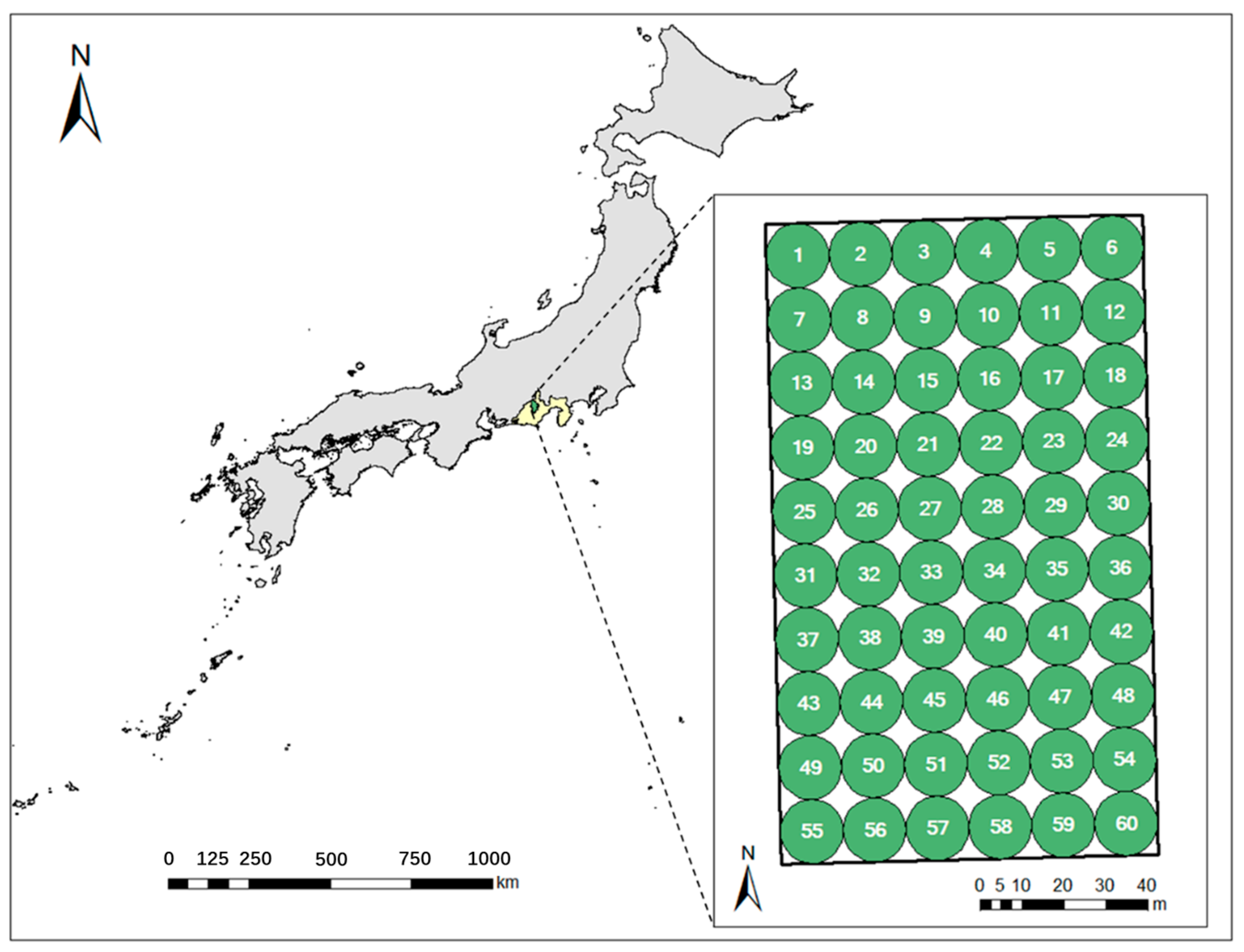
2.1. Study Area
2.2. Field Sampling and Digital Hemisphere Photography Processing
2.3. Sentinel-2 Data and Processing
2.4. Reported Vegetation Indices and New Spectral Index Development
2.5. Statistical Criteria
3. Results
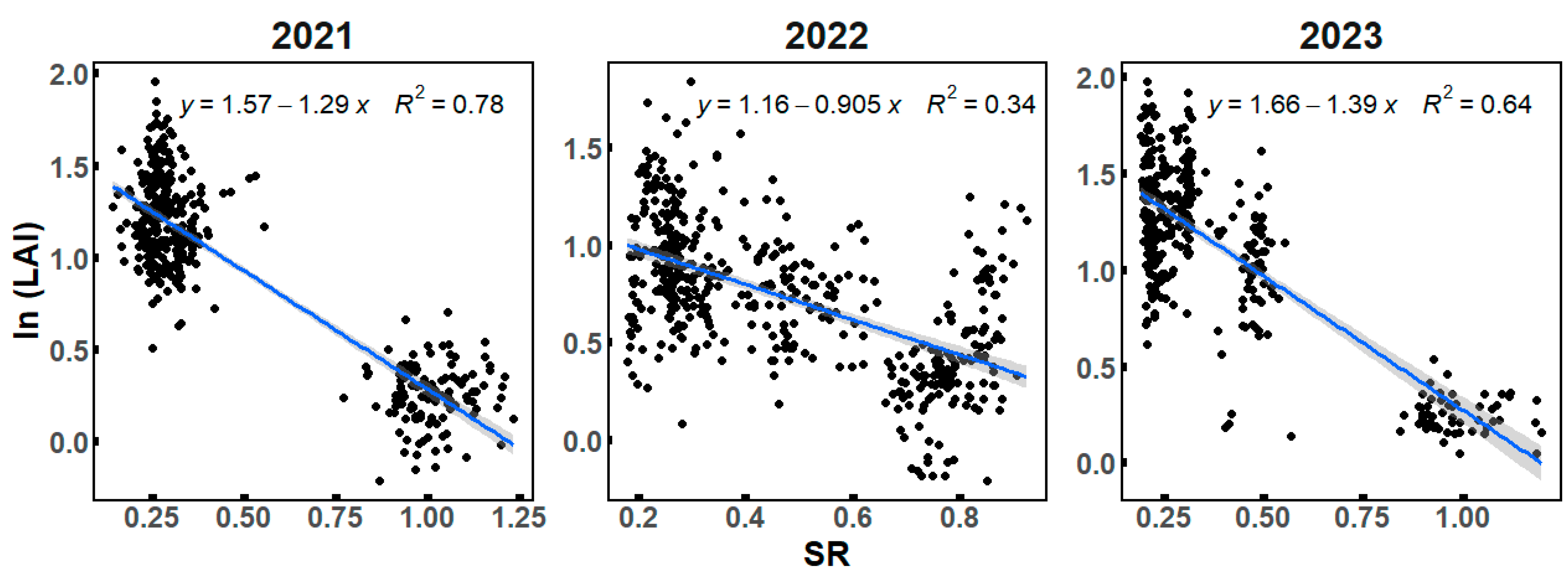
3.1. Annual and Spatial Variations of Ground LAI Derived from DHP
3.2. Evaluations of Reported Spectral Indices
3.3. Performance of the Developed Indices
4. Discussion
4.1. Annual, Seasonal, and Spatial Variability of LAI in Temperate Forests
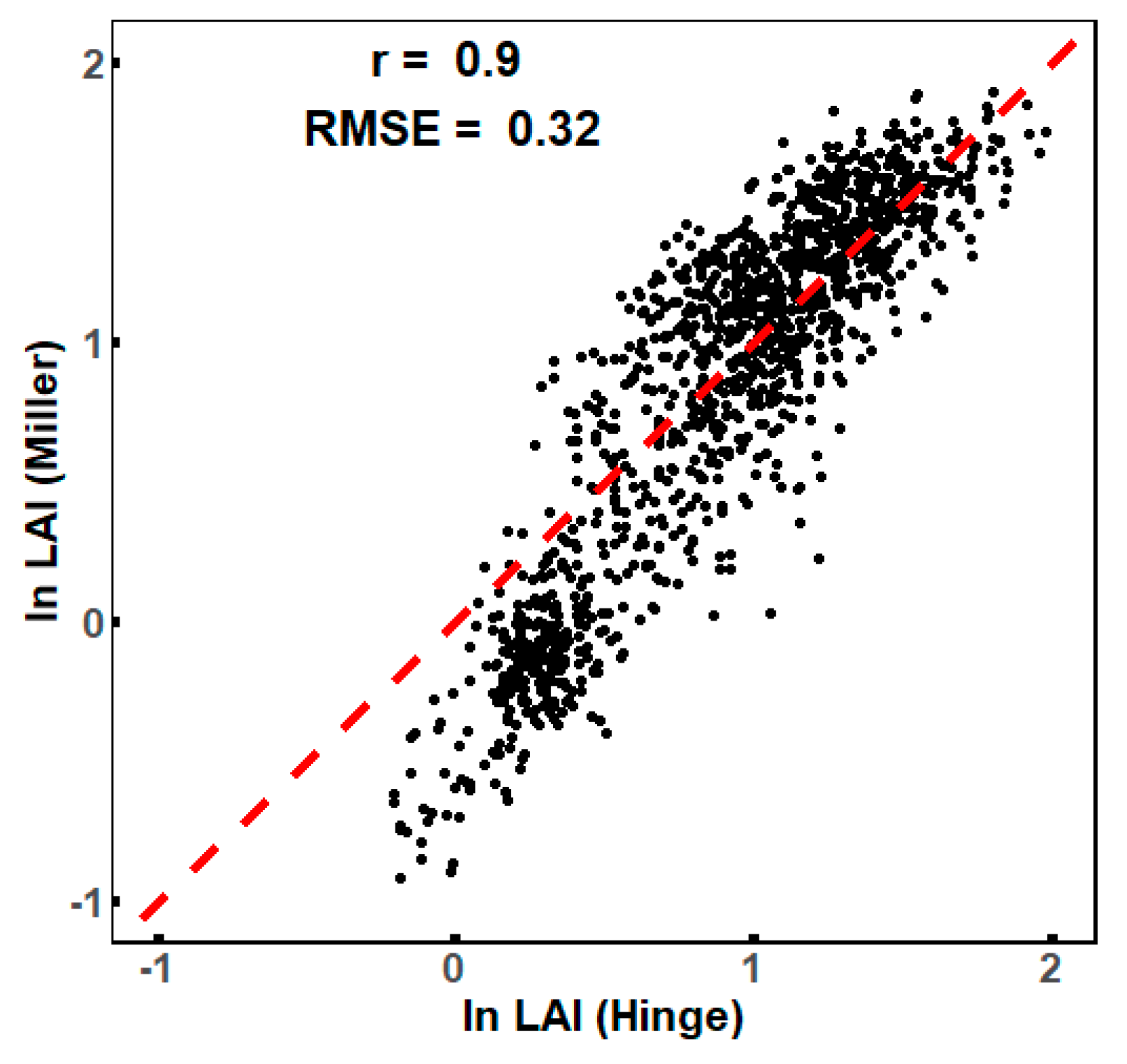
4.2. DHP-Based LAI Can Be Deviated with Different Processing Approaches
4.3. Developed VIs vs. Reported VIs
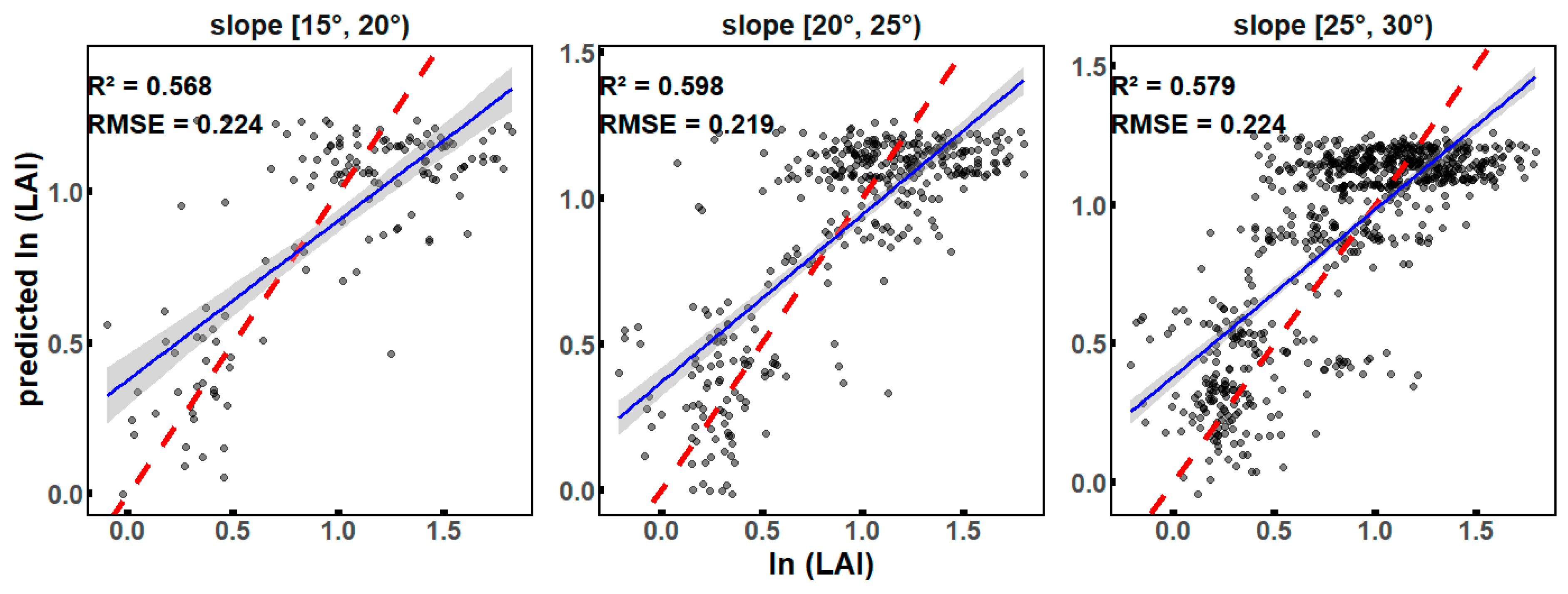
4.4. Limitation of VIs and Future Studies
5. Conclusions
Author Contributions
Funding
Data Availability Statement
Acknowledgments
Conflicts of Interest
References
- Chen, J.M.; Black, T.A. Defining Leaf Area Index for Non-flat Leaves. Plant Cell Environ. 1992, 15, 421–429. [Google Scholar] [CrossRef]
- Cañete-Salinas, P.; Zamudio, F.; Yáñez, M.; Gajardo, J.; Valdés, H.; Espinosa, C.; Venegas, J.; Retamal, L.; Ortega-Farias, S.; Acevedo-Opazo, C. Evaluation of Models to Determine LAI on Poplar Stands Using Spectral Indices from Sentinel-2 Satellite Images. Ecol. Model. 2020, 428, 109058. [Google Scholar] [CrossRef]
- Gilardelli, C.; Orlando, F.; Movedi, E.; Confalonieri, R. Quantifying the Accuracy of Digital Hemispherical Photography for Leaf Area Index Estimates on Broad-Leaved Tree Species. Sensors 2018, 18, 1028. [Google Scholar] [CrossRef]
- Xie, X.; Li, A.; Jin, H.; Tan, J.; Wang, C.; Lei, G.; Zhang, Z.; Bian, J.; Nan, X. Assessment of Five Satellite-Derived LAI Datasets for GPP Estimations through Ecosystem Models. Sci. Total Environ. 2019, 690, 1120–1130. [Google Scholar] [CrossRef] [PubMed]
- Breda, N.J.J. Ground-Based Measurements of Leaf Area Index: A Review of Methods, Instruments and Current Controversies. J. Exp. Bot. 2003, 54, 2403–2417. [Google Scholar] [CrossRef]
- Meyer, L.H.; Heurich, M.; Beudert, B.; Premier, J.; Pflugmacher, D. Comparison of Landsat-8 and Sentinel-2 Data for Estimation of Leaf Area Index in Temperate Forests. Remote Sens. 2019, 11, 1160. [Google Scholar] [CrossRef]
- Gan, Y.; Wang, Q.; Matsuzawa, T.; Song, G.; Iio, A. Multivariate Regressions Coupling Colorimetric and Textural Features Derived from UAV-Based RGB Images Can Trace Spatiotemporal Variations of LAI Well in a Deciduous Forest. Int. J. Remote Sens. 2023, 44, 4559–4577. [Google Scholar] [CrossRef]
- Tillack, A.; Clasen, A.; Kleinschmit, B.; Förster, M. Estimation of the Seasonal Leaf Area Index in an Alluvial Forest Using High-Resolution Satellite-Based Vegetation Indices. Remote Sens. Environ. 2014, 141, 52–63. [Google Scholar] [CrossRef]
- Jonckheere, I.; Fleck, S.; Nackaerts, K.; Muys, B.; Coppin, P.; Weiss, M.; Baret, F. Review of Methods for in Situ Leaf Area Index Determination. Agric. For. Meteorol. 2004, 121, 19–35. [Google Scholar] [CrossRef]
- Brenner, A.J.; Cueto Romero, M.; Garcia Haro, J.; Gilabert, M.A.; Incoll, L.D.; Martinez Fernandez, J.; Porter, E.; Pugnaire, F.I.; Younis, M.T. A Comparison of Direct and Indirect Methods for Measuring Leaf and Surface Areas of Individual Bushes. Plant Cell Environ. 1995, 18, 1332–1340. [Google Scholar] [CrossRef]
- Fang, H.; Baret, F.; Plummer, S.; Schaepman-Strub, G. An Overview of Global Leaf Area Index (LAI): Methods, Products, Validation, and Applications. Rev. Geophys. 2019, 57, 739–799. [Google Scholar] [CrossRef]
- Zhang, Y.; Chen, J.M.; Miller, J.R. Determining Digital Hemispherical Photograph Exposure for Leaf Area Index Estimation. Agric. For. Meteorol. 2005, 133, 166–181. [Google Scholar] [CrossRef]
- Liu, J.; Li, L.; Akerblom, M.; Wang, T.; Skidmore, A.; Zhu, X.; Heurich, M. Comparative Evaluation of Algorithms for Leaf Area Index Estimation from Digital Hemispherical Photography through Virtual Forests. Remote Sens. 2021, 13, 3325. [Google Scholar] [CrossRef]
- Rhoads, A.G.; Hamburg, S.P.; Fahey, T.J.; Siccama, T.G.; Kobe, R. Comparing Direct and Indirect Methods of Assessing Canopy Structure in a Northern Hardwood Forest. Can. J. For. Res. 2004, 34, 584–591. [Google Scholar] [CrossRef]
- Jonckheere, I.; Nackaerts, K.; Muys, B.; Coppin, P. Assessment of Automatic Gap Fraction Estimation of Forests from Digital Hemispherical Photography. Agric. For. Meteorol. 2005, 132, 96–114. [Google Scholar] [CrossRef]
- Brown, L.A.; Morris, H.; Leblanc, S.; Bai, G.; Lanconelli, C.; Gobron, N.; Meier, C.; Dash, J. HemiPy: A Python Module for Automated Estimation of Forest Biophysical Variables and Uncertainties from Digital Hemispherical Photographs. Methods Ecol. Evol. 2023, 14, 2329–2340. [Google Scholar] [CrossRef]
- Keenan, T.F.; Darby, B.; Felts, E.; Sonnentag, O.; Friedl, M.A.; Hufkens, K.; O’Keefe, J.; Klosterman, S.; Munger, J.W.; Toomey, M.; et al. Tracking Forest Phenology and Seasonal Physiology Using Digital Repeat Photography: A Critical Assessment. Ecol. Appl. 2014, 24, 1478–1489. [Google Scholar] [CrossRef]
- Vrieling, A.; Meroni, M.; Darvishzadeh, R.; Skidmore, A.K.; Wang, T.; Zurita-Milla, R.; Oosterbeek, K.; O’Connor, B.; Paganini, M. Vegetation Phenology from Sentinel-2 and Field Cameras for a Dutch Barrier Island. Remote Sens. Environ. 2018, 215, 517–529. [Google Scholar] [CrossRef]
- Mudi, S.; Paramanik, S.; Behera, M.D.; Prakash, A.J.; Deep, N.R.; Kale, M.P.; Kumar, S.; Sharma, N.; Pradhan, P.; Chavan, M.; et al. Moderate Resolution LAI Prediction Using Sentinel-2 Satellite Data and Indirect Field Measurements in Sikkim Himalaya. Environ. Monit. Assess. 2022, 194, 897. [Google Scholar] [CrossRef] [PubMed]
- Kurbanov, E.A.; Vorobev, O.N.; Lezhnin, S.A.; Dergunov, D.M.; Wang, Y. Forest Cover Trend Analysis Using MODIS Time Series and Its Climatic Responses in the Mari El Republic of Russia. IOP Conf. Ser. Earth Environ. Sci. 2021, 932, 012003. [Google Scholar] [CrossRef]
- Behera, M.D.; Krishna, J.S.R.; Paramanik, S.; Kumar, S.; Behera, S.K.; Anto, S.; Singh, S.N.; Verma, A.K.; Barik, S.K.; Mohanta, M.R.; et al. Digital Hemispherical Photographs and Sentinel-2 Multi-Spectral Imagery for Mapping Leaf Area Index at Regional Scale over a Tropical Deciduous Forest. Trop. Ecol. 2024, 65, 258–270. [Google Scholar] [CrossRef]
- Wang, Q.; Putri, N.A.; Gan, Y.; Song, G. Combining Both Spectral and Textural Indices for Alleviating Saturation Problem in Forest LAI Estimation Using Sentinel-2 Data. Geocarto Int. 2022, 37, 10511–10531. [Google Scholar] [CrossRef]
- Drusch, M.; Del Bello, U.; Carlier, S.; Colin, O.; Fernandez, V.; Gascon, F.; Hoersch, B.; Isola, C.; Laberinti, P.; Martimort, P.; et al. Sentinel-2: ESA’s Optical High-Resolution Mission for GMES Operational Services. Remote Sens. Environ. 2012, 120, 25–36. [Google Scholar] [CrossRef]
- Fassnacht, K.S.; Gower, S.T.; MacKenzie, M.D.; Nordheim, E.V.; Lillesand, T.M. Estimating the Leaf Area Index of North Central Wisconsin Forests Using the Landsat Thematic Mapper. Remote Sens. Environ. 1997, 61, 229–245. [Google Scholar] [CrossRef]
- Heiskanen, J.; Rautiainen, M.; Stenberg, P.; Mõttus, M.; Vesanto, V.-H. Sensitivity of Narrowband Vegetation Indices to Boreal Forest LAI, Reflectance Seasonality and Species Composition. ISPRS J. Photogramm. Remote Sens. 2013, 78, 1–14. [Google Scholar] [CrossRef]
- Li, Y.; Ma, Q.; Chen, J.M.; Croft, H.; Luo, X.; Zheng, T.; Rogers, C.; Liu, J. Fine-Scale Leaf Chlorophyll Distribution across a Deciduous Forest through Two-Step Model Inversion from Sentinel-2 Data. Remote Sens. Environ. 2021, 264, 112618. [Google Scholar] [CrossRef]
- Qiao, K.; Zhu, W.; Xie, Z.; Wu, S.; Li, S. New Three Red-Edge Vegetation Index (VI3RE) for Crop Seasonal LAI Prediction Using Sentinel-2 Data. Int. J. Appl. Earth Obs. Geoinf. 2024, 130, 103894. [Google Scholar] [CrossRef]
- Zheng, J.; Wang, M.; Liang, M.; Gao, Y.; Tan, M.L.; Liu, M.; Wang, X. Influence of Terrain on MODIS and GLASS Leaf Area Index (LAI) Products in Qinling Mountains Forests. Forests 2024, 15, 1871. [Google Scholar] [CrossRef]
- Gong, Z.; Ge, W.; Guo, J.; Liu, J. Satellite Remote Sensing of Vegetation Phenology: Progress, Challenges, and Opportunities. ISPRS J. Photogramm. Remote Sens. 2024, 217, 149–164. [Google Scholar] [CrossRef]
- Qiao, K.; Zhu, W.; Xie, Z. Application Conditions and Impact Factors for Various Vegetation Indices in Constructing the LAI Seasonal Trajectory over Different Vegetation Types. Ecol. Indic. 2020, 112, 106153. [Google Scholar] [CrossRef]
- Turner, D.P.; Cohen, W.B.; Kennedy, R.E.; Fassnacht, K.S.; Briggs, J.M. Relationships between Leaf Area Index and Landsat TM Spectral Vegetation Indices across Three Temperate Zone Sites. Remote Sens. Environ. 1999, 70, 52–68. [Google Scholar] [CrossRef]
- Gu, Y.; Wylie, B.K.; Howard, D.M.; Phuyal, K.P.; Ji, L. NDVI Saturation Adjustment: A New Approach for Improving Cropland Performance Estimates in the Greater Platte River Basin, USA. Ecol. Indic. 2013, 30, 1–6. [Google Scholar] [CrossRef]
- Macfarlane, C.; Ryu, Y.; Ogden, G.N.; Sonnentag, O. Digital Canopy Photography: Exposed and in the Raw. Agric. For. Meteorol. 2014, 197, 244–253. [Google Scholar] [CrossRef]
- Bequet, R.; Campioli, M.; Kint, V.; Vansteenkiste, D.; Muys, B.; Ceulemans, R. Leaf Area Index Development in Temperate Oak and Beech Forests Is Driven by Stand Characteristics and Weather Conditions. Trees 2011, 25, 935–946. [Google Scholar] [CrossRef]
- Le Dantec, V.; Dufrêne, E.; Saugier, B. Interannual and Spatial Variation in Maximum Leaf Area Index of Temperate Deciduous Stands. For. Ecol. Manag. 2000, 134, 71–81. [Google Scholar] [CrossRef]
- Sola, I.; García-Martín, A.; Sandonís-Pozo, L.; Álvarez-Mozos, J.; Pérez-Cabello, F.; González-Audícana, M.; Montorio Llovería, R. Assessment of Atmospheric Correction Methods for Sentinel-2 Images in Mediterranean Landscapes. Int. J. Appl. Earth Obs. Geoinf. 2018, 73, 63–76. [Google Scholar] [CrossRef]
- Wu, T.; Zhang, Z.; Wang, Q.; Jin, W.; Meng, K.; Wang, C.; Yin, G.; Xu, B.; Shi, Z. Estimating Rice Leaf Area Index at Multiple Growth Stages with Sentinel-2 Data: An Evaluation of Different Retrieval Algorithms. Eur. J. Agron. 2024, 161, 127362. [Google Scholar] [CrossRef]
- Pan, H.; Chen, Z.; Ren, J.; Li, H.; Wu, S. Modeling Winter Wheat Leaf Area Index and Canopy Water Content with Three Different Approaches Using Sentinel-2 Multispectral Instrument Data. IEEE J. Sel. Top. Appl. Earth Obs. Remote Sens. 2019, 12, 482–492. [Google Scholar] [CrossRef]
- Huete, A.R.; Liu, H.Q.; Van Leeuwen, W.J.D. The Use of Vegetation Indices in Forested Regions: Issues of Linearity and Saturation. In Proceedings of the IGARSS’97. 1997 IEEE International Geoscience and Remote Sensing Symposium Proceedings. Remote Sensing—A Scientific Vision for Sustainable Development, Singapore, 3–8 August 1997; IEEE: Piscataway, NJ, USA, 1997; Volume 4, pp. 1966–1968. [Google Scholar]
- Gitelson, A.A.; Kaufman, Y.J.; Merzlyak, M.N. Use of a Green Channel in Remote Sensing of Global Vegetation from EOS-MODIS. Remote Sens. Environ. 1996, 58, 289–298. [Google Scholar] [CrossRef]
- Kaufman, Y.J.; Tanre, D. Atmospherically Resistant Vegetation Index (ARVI) for EOS-MODIS. IEEE Trans. Geosci. Remote Sens. 1992, 30, 261–270. [Google Scholar] [CrossRef]
- Freden, S.C.; Mercanti, E.P.; Becker, M.A. Third Earth Resources Technology Satellite-1 Symposium Volume 1: Technical Presentations, Section A; Report Number: NASA-SP-351-VOL-1-SECT-A; NASA: Washington, DC, USA, 1974. [Google Scholar]
- Castro, A.I.D.; Ehsani, R.; Buchanon, S.; Pybas, D.; Crane, J.H.; Peña, J.E.; Evans, E.A.; Carrillo, D. Detection of Laurel Wilt-Infested Avocado Trees Using Low Altitude Aerial Images.
- Qi, J.; Chehbouni, A.; Huete, A.R.; Kerr, Y.H.; Sorooshian, S. A Modified Soil Adjusted Vegetation Index. Remote Sens. Environ. 1994, 48, 119–126. [Google Scholar] [CrossRef]
- Mngadi, M.; Odindi, J.; Mutanga, O. The Utility of Sentinel-2 Spectral Data in Quantifying Above-Ground Carbon Stock in an Urban Reforested Landscape. Remote Sens. 2021, 13, 4281. [Google Scholar] [CrossRef]
- Tang, Y.; Zhou, Y.; Cheng, M.; Sun, C. Comprehensive Growth Index (CGI): A Comprehensive Indicator from UAV-Observed Data for Winter Wheat Growth Status Monitoring. Agronomy 2023, 13, 2883. [Google Scholar] [CrossRef]
- Hunt, E.R.; Cavigelli, M.; Daughtry, C.S.T.; Mcmurtrey, J.E.; Walthall, C.L. Evaluation of Digital Photography from Model Aircraft for Remote Sensing of Crop Biomass and Nitrogen Status. Precis. Agric. 2005, 6, 359–378. [Google Scholar] [CrossRef]
- Bannari, A.; Staenz, K.; Haboudane, D.; Khurshid, K. Sensitivity Analysis of Chlorophyll Indices to Soil Optical Properties Using Ground-Reflectance Data. In Proceedings of the 2006 IEEE International Symposium on Geoscience and Remote Sensing, Denver, CO, USA, 31 July–4 August 2006; IEEE: Piscataway, NJ, USA; pp. 120–123. [Google Scholar]
- Richardson, A.J.; Wiegand, C.L. Distinguishing Vegetation from Soil Background Information. Photogramm. Eng. Remote Sens. 1977, 43, 1541–1552. [Google Scholar]
- Zhao, B.; Duan, A.; Ata-Ul-Karim, S.T.; Liu, Z.; Chen, Z.; Gong, Z.; Zhang, J.; Xiao, J.; Liu, Z.; Qin, A.; et al. Exploring New Spectral Bands and Vegetation Indices for Estimating Nitrogen Nutrition Index of Summer Maize. Eur. J. Agron. 2018, 93, 113–125. [Google Scholar] [CrossRef]
- Xue, J.; Su, B. Significant Remote Sensing Vegetation Indices: A Review of Developments and Applications. J. Sens. 2017, 2017, 1353691. [Google Scholar] [CrossRef]
- Gitelson, A.A. Wide Dynamic Range Vegetation Index for Remote Quantification of Biophysical Characteristics of Vegetation. J. Plant Physiol. 2004, 161, 165–173. [Google Scholar] [CrossRef] [PubMed]
- Clevers, J.G.P.W.; Gitelson, A.A. Remote Estimation of Crop and Grass Chlorophyll and Nitrogen Content Using Red-Edge Bands on Sentinel-2 and -3. Int. J. Appl. Earth Obs. Geoinf. 2013, 23, 344–351. [Google Scholar] [CrossRef]
- Majasalmi, T.; Rautiainen, M. The Potential of Sentinel-2 Data for Estimating Biophysical Variables in a Boreal Forest: A Simulation Study. Remote Sens. Lett. 2016, 7, 427–436. [Google Scholar] [CrossRef]
- Xu, X.; Gu, X.; Song, X.; Li, C.; Huang, W. Assessing Rice Chlorophyll Content with Vegetation Indices from Hyperspectral Data. In Computer and Computing Technologies in Agriculture IV; Li, D., Liu, Y., Chen, Y., Eds.; IFIP Advances in Information and Communication Technology; Springer: Berlin/Heidelberg, Germany, 2011; Volume 344, pp. 296–303. ISBN 978-3-642-18332-4. [Google Scholar]
- Dash, J.; Curran, P.J. Evaluation of the MERIS Terrestrial Chlorophyll Index (MTCI). Adv. Space Res. 2007, 39, 100–104. [Google Scholar] [CrossRef]
- Jin, J.; Arief Pratama, B.; Wang, Q. Tracing Leaf Photosynthetic Parameters Using Hyperspectral Indices in an Alpine Deciduous Forest. Remote Sens. 2020, 12, 1124. [Google Scholar] [CrossRef]
- Asner, G.P.; Scurlock, J.M.O.; Hicke, J.A. Global Synthesis of Leaf Area Index Observations: Implications for Ecological and Remote Sensing Studies. Glob. Ecol. Biogeogr. 2003, 12, 191–205. [Google Scholar] [CrossRef]
- Eriksson, H.; Eklundh, L.; Hall, K.; Lindroth, A. Estimating LAI in Deciduous Forest Stands. Agric. For. Meteorol. 2005, 129, 27–37. [Google Scholar] [CrossRef]
- Xu, Z.; Liu, Q.; Du, W.; Zhou, G.; Qin, L.; Sun, Z. Modelling Leaf Phenology of Some Trees with Accumulated Temperature in a Temperate Forest in Northeast China. For. Ecol. Manag. 2021, 489, 119085. [Google Scholar] [CrossRef]
- Liu, Z.; Chen, J.M.; Jin, G.; Qi, Y. Estimating Seasonal Variations of Leaf Area Index Using Litterfall Collection and Optical Methods in Four Mixed Evergreen–Deciduous Forests. Agric. For. Meteorol. 2015, 209–210, 36–48. [Google Scholar] [CrossRef]
- Xie, Y.; Thammavong, H.T.; Park, D.S. The Ecological Implications of Intra- and Inter-species Variation in Phenological Sensitivity. New Phytol. 2022, 236, 760–773. [Google Scholar] [CrossRef] [PubMed]
- Liu, Z.; Jiang, F.; Zhu, Y.; Li, F.; Jin, G. Spatial Heterogeneity of Leaf Area Index in a Temperate Old-Growth Forest: Spatial Autocorrelation Dominates over Biotic and Abiotic Factors. Sci. Total Environ. 2018, 634, 287–295. [Google Scholar] [CrossRef] [PubMed]
- Iio, A.; Hikosaka, K.; Anten, N.P.R.; Nakagawa, Y.; Ito, A. Global Dependence of Field-observed Leaf Area Index in Woody Species on Climate: A Systematic Review. Glob. Ecol. Biogeogr. 2014, 23, 274–285. [Google Scholar] [CrossRef]
- Torres-Sánchez, J.; Peña, J.M.; De Castro, A.I.; López-Granados, F. Multi-temporal mapping of the vegetation fraction in early-season wheat fields using images from UAV. Comput. Electron. Agric. 2014, 103, 104–113. [Google Scholar] [CrossRef]
- Amin, E.; Verrelst, J.; Rivera-Caicedo, J.P.; Pipia, L.; Ruiz-Verdú, A.; Moreno, J. Prototyping Sentinel-2 Green LAI and Brown LAI Products for Cropland Monitoring. Remote Sens. Environ. 2021, 255, 112168. [Google Scholar] [CrossRef]
- Immitzer, M.; Vuolo, F.; Atzberger, C. First Experience with Sentinel-2 Data for Crop and Tree Species Classifications in Central Europe. Remote Sens. 2016, 8, 166. [Google Scholar] [CrossRef]
- Huete, A. A Comparison of Vegetation Indices over a Global Set of TM Images for EOS-MODIS. Remote Sens. Environ. 1997, 59, 440–451. [Google Scholar] [CrossRef]
- Kira, O.; Nguy-Robertson, A.L.; Arkebauer, T.J.; Linker, R.; Gitelson, A.A. Informative Spectral Bands for Remote Green LAI Estimation in C3 and C4 Crops. Agric. For. Meteorol. 2016, 218–219, 243–249. [Google Scholar] [CrossRef]
- Dong, T.; Liu, J.; Shang, J.; Qian, B.; Ma, B.; Kovacs, J.M.; Walters, D.; Jiao, X.; Geng, X.; Shi, Y. Assessment of Red-Edge Vegetation Indices for Crop Leaf Area Index Estimation. Remote Sens. Environ. 2019, 222, 133–143. [Google Scholar] [CrossRef]
- Peng, Y.; Nguy-Robertson, A.; Arkebauer, T.; Gitelson, A. Assessment of Canopy Chlorophyll Content Retrieval in Maize and Soybean: Implications of Hysteresis on the Development of Generic Algorithms. Remote Sens. 2017, 9, 226. [Google Scholar] [CrossRef]
- Soudani, K.; François, C.; Le Maire, G.; Le Dantec, V.; Dufrêne, E. Comparative Analysis of IKONOS, SPOT, and ETM+ Data for Leaf Area Index Estimation in Temperate Coniferous and Deciduous Forest Stands. Remote Sens. Environ. 2006, 102, 161–175. [Google Scholar] [CrossRef]
- Korhonen, L.; Hadi; Packalen, P.; Rautiainen, M. Comparison of Sentinel-2 and Landsat 8 in the Estimation of Boreal Forest Canopy Cover and Leaf Area Index. Remote Sens. Environ. 2017, 195, 259–274. [Google Scholar] [CrossRef]
- Singh, S. Understanding the Role of Slope Aspect in Shaping the Vegetation Attributes and Soil Properties in Montane Ecosystems. Trop. Ecol. 2018, 59, 417–430. [Google Scholar]
- Ma, Y.; He, T.; McVicar, T.R.; Liang, S.; Liu, T.; Peng, W.; Song, D.-X.; Tian, F. Quantifying How Topography Impacts Vegetation Indices at Various Spatial and Temporal Scales. Remote Sens. Environ. 2024, 312, 114311. [Google Scholar] [CrossRef]
- Yang, K.; Gong, Y.; Fang, S.; Duan, B.; Yuan, N.; Peng, Y.; Wu, X.; Zhu, R. Combining Spectral and Texture Features of UAV Images for the Remote Estimation of Rice LAI throughout the Entire Growing Season. Remote Sens. 2021, 13, 3001. [Google Scholar] [CrossRef]
- Li, H.; Yan, X.; Su, P.; Su, Y.; Li, J.; Xu, Z.; Gao, C.; Zhao, Y.; Feng, M.; Shafiq, F.; et al. Estimation of Winter Wheat LAI Based on Color Indices and Texture Features of RGB Images Taken by UAV. J. Sci. Food Agric. 2025, 105, 189–200. [Google Scholar] [CrossRef] [PubMed]


| Index | Abbreviation | Formula | References |
|---|---|---|---|
| Normalized difference vegetation index | NDVI | (NIR − R)/(NIR + R) | [38] |
| Enhanced vegetation index | EVI | 2.5 × (NIR − R)/(NIR + 6× R − 7.5B + 1) | [39] |
| Normalized green difference vegetation index | NGDVI | (NIR − G)/(NIR + G) | [40] |
| Atmospheric resistance vegetation index | ARVI | (NIR − 2R + B)/(NIR + 2R − B) | [41] |
| Ratio vegetation index I | RVI54 | SWIR1/NIR | [42] |
| Ratio vegetation index II | RVI64 | SWIR2/NIR | [42] |
| Excess green index | EXG | 2G − R − B | [43] |
| Excess green minus red index | EXGR | 2G − 2.4R | [43] |
| Excess red index | EXR | 1.4R − B | [43] |
| Modified soil adjustment vegetation index | MSAVI | (2NIR + 1 − sqrt((2NIR + 1)2 − 8(NIR − R)))/2 | [44] |
| Modified second ratio index | MSRI | ((NIR/R) − 1)/sqrt((NIR/R) + 1) | [45] |
| Moisture vegetation index | MVI | sqrt((NIR − R)/(NIR + R) + 0.5) | [20] |
| Normalized difference index | NDI | (NIR − SWIR1)/(NIR + SWIR1) | [46] |
| Normalized green-red difference index | NGRDI | (G − R)/(G + R) | [47] |
| Chlorophyll normalized vegetation index | NPCI | (R − B)/(R + B) | [43] |
| Optimization of soil regulatory vegetation index | OSAVI | 1.6(NIR − R)/(NIR + R + 0.16) | [48] |
| Redness index | RI | (R − G)/(R + G) | [49] |
| Ratio vegetation index | RVI | NIR/R | [50] |
| Source address validation improvement | SAVI | 1.5(NIR − R)/(NIR + R + 0.5) | [39] |
| Structure-independent pigment index | SIPI | (NIR − B)/(NIR + B) | [48] |
| Simple ratio pigment index | SRPI | B/R | [48] |
| Transform chlorophyll absorption index | TCARI | 3((RE1 − R) − 0.2(RE1 − G))/(RE1/R) | [48] |
| Transformed vegetation index | TVI | 60(NIR − G) − 100(R − G) | [50] |
| Visible atmospherically resistant index | VARI | (G − R)/(G + R − B) | [40] |
| Visible difference vegetation index | VDVI | (2G − (R + B))/(2G + (R + B)) | [51] |
| Wide dynamic range vegetation index | WDRVI | (NIR − R)/(NIR + R) | [52] |
| Red edge chlorophyll index | CIred-edge | (RE3/RE1) − 1 | [53] |
| Inverted red edge chlorophyll index | IRECI | (RE3 − R)/(RE1/RE2) | [54] |
| Modified chlorophyll absorption ratio index | MCARI | ((RE1 − R) − 0.2 * (RE1 − G)) × (RE1 − R) | [55] |
| MERIS terrestrial chlorophyll index | MTCI | (RE2-RE1)/(RE1-R) | [56] |
| Sentinel-2 red-edge position index | S2REP | 705 + 35× ((((RE3 + R)/2) − RE1)/(RE2 − RE1)) | [54] |
| Red-edge-based plant index | REPI | (0.5× (RE3 + R) − RE1)/(RE2 − RE1) | [38] |
| Index Type | Formula of Index |
|---|---|
| λ (λ1) | λ |
| SR (λ1, λ2) | |
| D (λ1, λ2) | λ1− λ2 |
| ND (λ1, λ2) | |
| ID (λ1, λ2) |
| Year | Leaf Stage | I | E(I) | Var | SD | p |
|---|---|---|---|---|---|---|
| 2021 | Flushing | 0.100 | 6.374 | 0.084 | −0.017 | 0.007 |
| Maturity | 0.291 | 6.374 | 0.000 | −0.006 | 0.002 | |
| Senescence | −0.199 | 6.374 | 1.000 | −0.006 | 0.002 | |
| 2022 | Flushing | −0.042 | 6.374 | 0.824 | −0.004 | 0.002 |
| Maturity | −0.261 | 6.374 | 0.998 | −0.017 | 0.007 | |
| Senescence | −0.032 | 6.374 | 0.672 | −0.007 | 0.003 | |
| 2023 | Flushing | 0.271 | 6.374 | 0.000 | −0.017 | 0.007 |
| Maturity | 0.302 | 6.374 | 0.000 | −0.008 | 0.004 | |
| Senescence | −0.115 | 6.374 | 0.989 | −0.006 | 0.002 |
| VIs | Total | 2021 | 2022 | 2023 | ||||||
|---|---|---|---|---|---|---|---|---|---|---|
| Flushing | Maturity | Senescence | Flushing | Maturity | Senescence | Flushing | Maturity | Senescence | ||
| NDVI | 0.407 | −0.028 | −0.070 | 0.949 | 0.607 | −0.082 | 0.305 | 0.170 | 0.136 | 0.627 |
| EVI | 0.450 | −0.051 | 0.035 | 0.945 | 0.633 | −0.036 | 0.602 | 0.008 | −0.136 | 0.460 |
| GNDVI | 0.185 | −0.014 | −0.070 | 0.943 | 0.169 | −0.100 | 0.038 | 0.209 | 0.142 | 0.387 |
| ARVI | 0.539 | −0.038 | −0.032 | 0.949 | 0.727 | −0.059 | 0.480 | 0.166 | 0.142 | 0.759 |
| RVI54 | −0.720 | 0.074 | −0.067 | −0.922 | −0.708 | 0.048 | −0.729 | 0.011 | −0.063 | −0.895 |
| RVI64 | −0.717 | 0.208 | 0.040 | −0.932 | −0.722 | 0.029 | −0.360 | −0.039 | −0.123 | −0.906 |
| EXG | 0.340 | −0.114 | −0.067 | 0.940 | 0.693 | −0.046 | 0.561 | −0.130 | −0.143 | 0.617 |
| EXGR | 0.151 | −0.012 | −0.024 | 0.938 | 0.688 | −0.042 | 0.355 | −0.091 | 0.095 | 0.648 |
| EXR | −0.052 | −0.005 | −0.023 | −0.903 | −0.573 | 0.033 | −0.165 | −0.195 | −0.138 | −0.587 |
| MSAVI | 0.468 | −0.044 | −0.023 | 0.945 | 0.709 | −0.092 | 0.536 | 0.051 | −0.038 | 0.373 |
| MSRI | 0.523 | −0.057 | −0.100 | 0.952 | 0.650 | −0.051 | 0.538 | 0.158 | 0.135 | 0.743 |
| MVI | 0.363 | −0.022 | −0.068 | 0.947 | 0.598 | −0.084 | 0.255 | 0.170 | 0.136 | 0.579 |
| NDI | 0.689 | −0.063 | 0.070 | 0.936 | 0.704 | −0.048 | 0.725 | −0.017 | 0.063 | 0.886 |
| NGRDI | 0.623 | −0.091 | −0.101 | 0.940 | 0.735 | −0.006 | 0.769 | 0.068 | 0.124 | 0.769 |
| NPCI | −0.601 | 0.082 | −0.099 | −0.882 | −0.521 | −0.125 | −0.743 | −0.032 | −0.083 | −0.451 |
| OSAVI | 0.446 | −0.033 | −0.042 | 0.949 | 0.691 | −0.092 | 0.426 | 0.081 | 0.046 | 0.456 |
| RI | −0.623 | 0.091 | 0.101 | −0.940 | −0.735 | 0.006 | −0.769 | −0.068 | −0.124 | −0.769 |
| RVI | 0.528 | −0.082 | −0.114 | 0.944 | 0.651 | −0.030 | 0.607 | 0.152 | 0.132 | 0.751 |
| SAVI | 0.456 | −0.037 | −0.014 | 0.946 | 0.710 | −0.100 | 0.489 | 0.034 | −0.058 | 0.372 |
| SIPI | 0.148 | −0.017 | −0.100 | 0.932 | 0.281 | −0.097 | −0.019 | 0.181 | 0.127 | 0.342 |
| SRPI | 0.581 | −0.086 | 0.089 | 0.895 | 0.497 | 0.123 | 0.656 | 0.033 | 0.087 | 0.504 |
| TCARI | 0.089 | 0.017 | 0.067 | 0.508 | 0.587 | −0.113 | 0.133 | −0.227 | −0.149 | −0.166 |
| TVI | 0.435 | −0.045 | 0.016 | 0.943 | 0.713 | −0.103 | 0.558 | −0.022 | −0.136 | 0.416 |
| VARI | 0.639 | −0.091 | −0.053 | 0.942 | 0.727 | 0.007 | 0.741 | 0.071 | 0.125 | 0.780 |
| VDVI | 0.522 | −0.097 | −0.130 | 0.951 | 0.706 | −0.060 | 0.662 | 0.068 | 0.121 | 0.798 |
| WDRVI | 0.407 | −0.028 | −0.070 | 0.949 | 0.607 | −0.082 | 0.305 | 0.170 | 0.136 | 0.627 |
| CIred-edge | 0.510 | −0.055 | −0.016 | 0.950 | 0.734 | −0.058 | 0.702 | −0.011 | −0.062 | 0.513 |
| MTCI | 0.455 | −0.073 | 0.063 | 0.930 | 0.210 | 0.165 | 0.616 | 0.201 | 0.048 | 0.475 |
| MCARI | 0.276 | 0.006 | −0.013 | 0.925 | 0.647 | −0.187 | 0.662 | −0.128 | −0.165 | 0.187 |
| IRECI | 0.510 | −0.084 | −0.040 | 0.950 | 0.719 | −0.043 | 0.667 | 0.111 | 0.113 | 0.669 |
| S2REP | 0.130 | −0.040 | 0.027 | 0.438 | 0.074 | 0.099 | 0.166 | −0.004 | 0.029 | −0.052 |
| REPI | 0.130 | −0.040 | 0.027 | 0.438 | 0.074 | 0.099 | 0.166 | −0.004 | 0.029 | −0.052 |
| Index Type | λ1 | λ2 | AIC | R2 | RMSE | RPD |
|---|---|---|---|---|---|---|
| λ | B8A | - | 1421.414 | 0.113 | 0.427 | 1.063 |
| SR | B12 | B7 | 501.701 | 0.576 | 0.295 | 1.537 |
| D | B5 | B7 | 1203.041 | 0.256 | 0.391 | 1.160 |
| ND | B7 | B12 | 504.850 | 0.575 | 0.296 | 1.535 |
| ID | B7 | B11 | 590.454 | 0.545 | 0.306 | 1.483 |
Disclaimer/Publisher’s Note: The statements, opinions and data contained in all publications are solely those of the individual author(s) and contributor(s) and not of MDPI and/or the editor(s). MDPI and/or the editor(s) disclaim responsibility for any injury to people or property resulting from any ideas, methods, instructions or products referred to in the content. |
© 2025 by the authors. Licensee MDPI, Basel, Switzerland. This article is an open access article distributed under the terms and conditions of the Creative Commons Attribution (CC BY) license (https://creativecommons.org/licenses/by/4.0/).
Share and Cite
Wang, X.; Gan, Y.; Iio, A.; Wang, Q. Using Vegetation Indices Developed for Sentinel-2 Multispectral Data to Track Spatiotemporal Changes in the Leaf Area Index of Temperate Deciduous Forests. Geomatics 2025, 5, 11. https://doi.org/10.3390/geomatics5010011
Wang X, Gan Y, Iio A, Wang Q. Using Vegetation Indices Developed for Sentinel-2 Multispectral Data to Track Spatiotemporal Changes in the Leaf Area Index of Temperate Deciduous Forests. Geomatics. 2025; 5(1):11. https://doi.org/10.3390/geomatics5010011
Chicago/Turabian StyleWang, Xuanwen, Yi Gan, Atsuhiro Iio, and Quan Wang. 2025. "Using Vegetation Indices Developed for Sentinel-2 Multispectral Data to Track Spatiotemporal Changes in the Leaf Area Index of Temperate Deciduous Forests" Geomatics 5, no. 1: 11. https://doi.org/10.3390/geomatics5010011
APA StyleWang, X., Gan, Y., Iio, A., & Wang, Q. (2025). Using Vegetation Indices Developed for Sentinel-2 Multispectral Data to Track Spatiotemporal Changes in the Leaf Area Index of Temperate Deciduous Forests. Geomatics, 5(1), 11. https://doi.org/10.3390/geomatics5010011