A Scoping Review of Landform Classification Using Geospatial Methods
Abstract
1. Introduction
2. Research Strategy
2.1. Research Questions
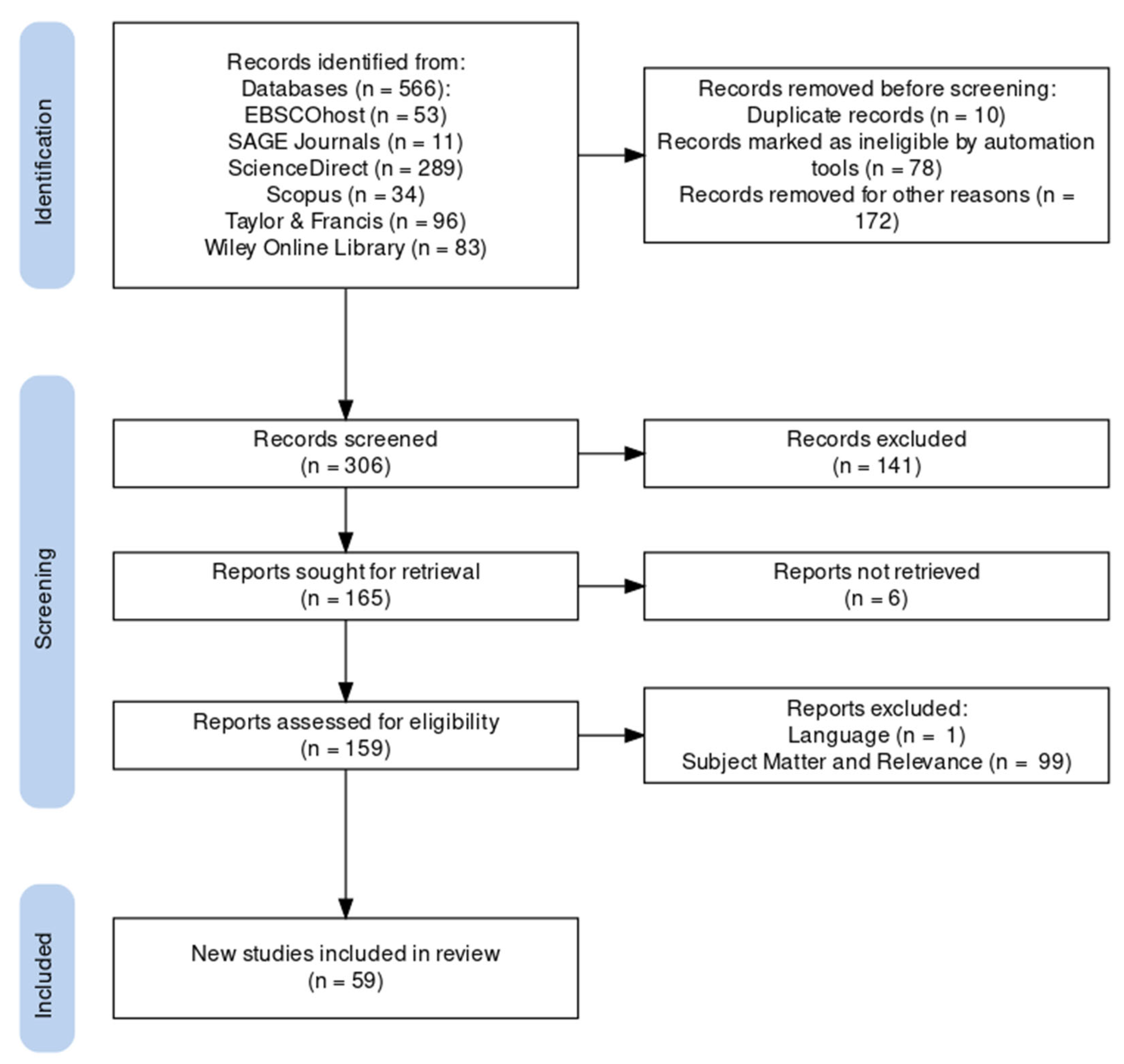
2.2. Article Screening
2.3. Data Extraction
3. Results and Discussions
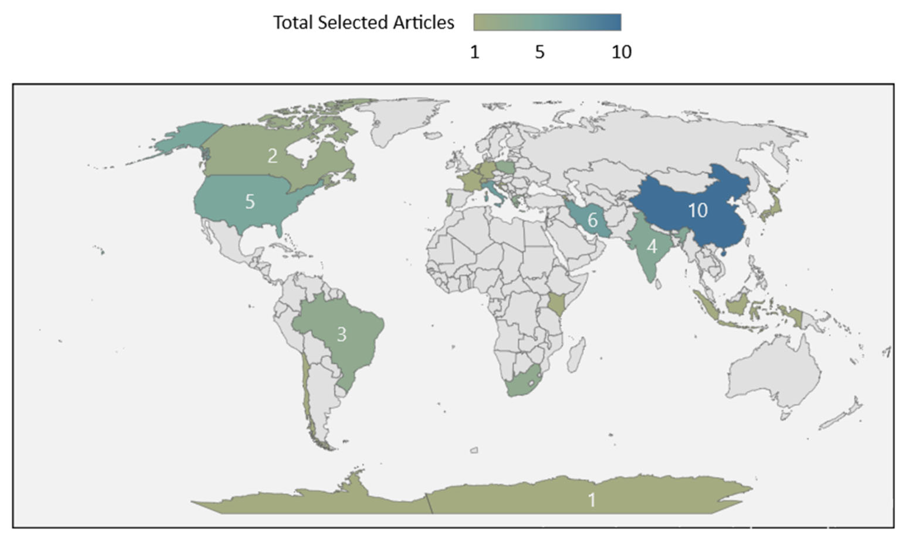
3.1. Geographical Distribution of Selected Articles (RQ1)
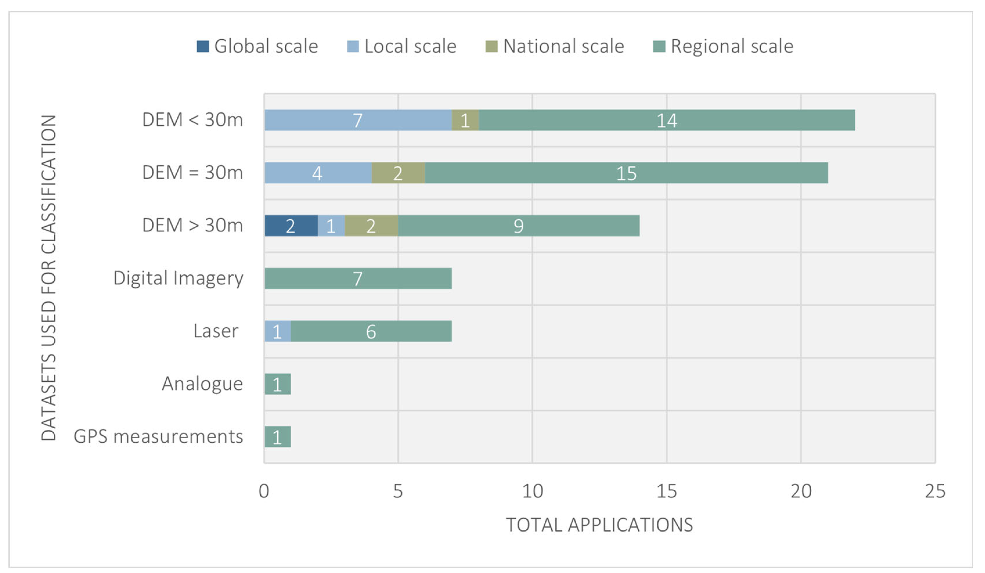
3.2. Datasets Used for Classifying Landforms (RQ2)
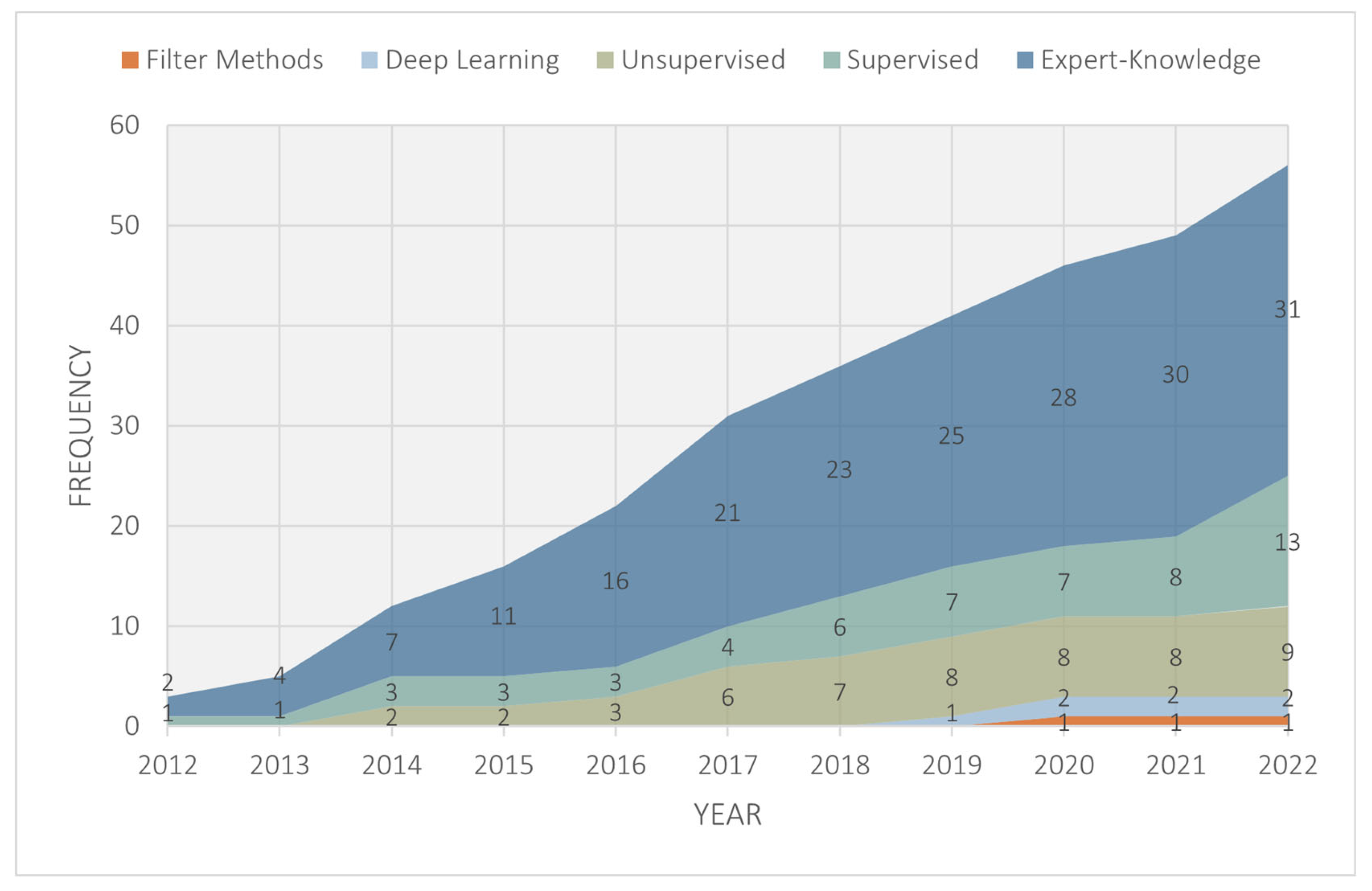
3.3. Analytical Approaches for Classifying Landforms (RQ3)
3.4. Methods Used for Validating Landform Classifications (RQ4)
4. Conclusions
Author Contributions
Funding
Acknowledgments
Conflicts of Interest
Appendix A
| Article Index | Title | Authors | Publication Year |
|---|---|---|---|
| A1 | GIS-based landform classification of Bronze Age archaeological sites on Crete Island | Argyriou, A.V., Teeuw, R.M., Sarris, A. | 2017 |
| A2 | Multi-resolution soil-landscape characterisation in KwaZulu Natal: Using geomorphons to classify local soilscapes for improved digital geomorphological modelling | Atkinson, J., de Clercq, W., Rozanov, A. | 2020 |
| A3 | Using textural analysis for regional landform and landscape mapping, Eastern Guiana Shield | Bugnicourt, P., Guitet, S., Santos, V.F., Blanc, L., Sotta, E.D., Barbier, N., Couteron, P. | 2018 |
| A4 | An approach to DEM analysis for landform classification based on local gradients | Camiz, S., Poscolieri, M. | 2018 |
| A5 | Semi-automated object-based landform classification modelling in a part of the Deccan Plateau of central India | Chattaraj, S., Srivastava, R., Barthwal, A.K., Giri, J.D., Mohekar, D.S., Obi Reddy, G.P., Daripa, A., Chatterji, S., Singh, S.K. | 2017 |
| A6 | The land morphology concept and mapping method and its application to mainland Portugal | Cunha, N.S., Magalhães, M.R., Domingos, T., Abreu, M.M., Withing, K. | 2018 |
| A7 | Delineation of main relief subdomains of central Amazonia for regional geomorphometric mapping with SRTM data | de Morisson Valeriano, M., de Fátima Rossetti, D. | 2020 |
| A8 | Application of the topographic position index to heterogeneous landscapes | de Reu, J., Bourgeois, J., Bats, M., Zwertvaegher, A., Gelorini, V., de Smedt, P., Chu Meirvenne, M., Verniers, J., Crombe, P. | 2013 |
| A9 | Evaluation of a spatially adaptive approach for land surface classification from digital elevation models | Dekavalla, M., Argialas, D. | 2017 |
| A10 | Automated object-based classification of topography from SRTM data | Drǎguţ, L., Eisank, C., Drăguţ, L., Eisank, C. | 2012 |
| A11 | Multi-modal deep learning for landform recognition | Du, L., You, X., Li, K., Meng, L., Cheng, G., Xiong, L., Wang, G. | 2019 |
| A12 | Toward geomorphometry of plains - Country-level unsupervised classification of low-relief areas (Poland) | Dyba, K., Jasiewicz, J. | 2022 |
| A13 | Farm-scale soil patterns derived from automated terrain classification | Flynn, T., Rozanov, A., Ellis, F., de Clercq, W., Clarke, C. | 2020 |
| A14 | Detecting and mapping karst landforms using object-based image analysis: Case study: Takht-Soleiman and Parava Mountains, Iran | Garajeh, M.K., Feizizadeh, B., Blaschke, T., Lakes, T. | 2022 |
| A15 | Algorithms vs. surveyors: A comparison of automated landform delineations and surveyed topographic positions from soil mapping in an Alpine environment | Gruber, F.E., Baruck, J., Geitner, C. | 2017 |
| A16 | Geomorphons — a pattern recognition approach to classification and mapping of landforms | Jasiewicz, J., Stepinski, T.F. | 2013 |
| A17 | Modeling global Hammond landform regions from 250-m elevation data | Karagulle, D., Frye, C., Sayre, R., Breyer, S., Aniello, P., Vaughan, R., Wright, D. | 2017 |
| A18 | Regional topographic classification in the North Shaanxi Loess Plateau based on catchment boundary profiles | Li, M., Yang, X., Na, J., Liu, K., Jia, Y., Xiong, L. | 2017 |
| A19 | Employment of Continuous Slope Cumulative Frequency Spectrum in geomorphology quantitative analysis—a case study on Loess Plateau | Lin, S., Chen, N. | 2022 |
| A20 | Automatic Landform Recognition from the Perspective ofWatershed Spatial Structure Based on Digital Elevation Models | Lin, S., Chen, N., He, Z. | 2022 |
| A21 | Landform classification based on landform geospatial structure—a case study on Loess Plateau of China | Lin, S., Xie, J., Deng, J., Qi, M., Chen, N. | 2022 |
| A22 | Regional and local topography subdivision and landform mapping using SRTM-derived data; a case study in southeastern Brazil | Manfre, L.A., de Albuquerque Nobrega, R.A., Quintanilha, J.A. | 2015 |
| A23 | Classification of landforms in Southern Portugal (Ria Formosa Basin) | Martins, F.M., Fernandez, H.M., Isidoro, J.M., Jordán, A., Zavala, L. | 2016 |
| A24 | Supervised classification of landforms in Arctic mountains | Mithan, H.T., Hales, T.C., Cleall, P.J. | 2019 |
| A25 | Landform classification using topography position index (case study; salt dome of Korsia-Darab Plain, Iran) | Mokarram, M., Roshan, G., Negahban, S. | 2015 |
| A26 | Investigation of the relationship between landform classes and electrical conductivity (EC) of water and soil using a fuzzy model in a GIS environment | Mokarram, M., Sathyamoorthy, D. | 2016 |
| A27 | Clustering of landforms using self-organizing maps (SOM) in the west of Fars province | Mokarram, M., Sathyamoorthy, D. | 2016 |
| A28 | Landform classification using a sub-pixel spatial attraction model to increase spatial resolution of digital elevation model (DEM) | Mokarrama, M., Hojati, M. | 2018 |
| A29 | Dynamics of coastal landform features along the southern Tamil Nadu of India by using remote sensing and Geographic Information System | Mujabar, P.S., Chandrasekar, N. | 2012 |
| A30 | Object-based large-scale terrain classification combined with segmentation optimization and terrain features: A case study in China | Na, J., Ding, H., Zhao, W., Liu, K., Tang, G., Pfeifer, N. | 2021 |
| A31 | Landform pattern recognition and classification for predicting soil types of the Uasin Gishu Plateau, Kenya | Ngunjiri, M.W., Libohova, Z., Owens, P.R., Schulze, D.G. | 2020 |
| A32 | Predicting Patagonian Landslides: Roles of Forest Cover and Wind Speed | Parra, E., Mohr, C.H., Korup, O. | 2021 |
| A33 | A GIS procedure for fast topographic characterization of seismic recording stations | Pessina, V., Fiorini, E. | 2014 |
| A34 | Multinomial logistic regression with soil diagnostic features and land surface parameters for soil mapping of Latium (Central Italy) | Piccini, C., Marchetti, A., Rivieccio, R., Napoli, R. | 2019 |
| A35 | Semi-Automated Classification of Landform Elements in Armenia Based on SRTM DEM using K-Means Unsupervised Classification | Piloyan, A., Konečný, M. | 2017 |
| A36 | Evaluation of TanDEM-X elevation data for geomorphological mapping and interpretation in high mountain environments — A case study from SE Tibet, China | Pipaud, I., Loibl, D., Lehmkuhl, F. | 2015 |
| A37 | GIS-based landform and LULC classifications in the Sub-Himalayan Kaljani Basin: Special reference to 2016 Flood | Roy, L., Das, S. | 2021 |
| A38 | Sensitivity of geomorphons to mapping specific landforms from a digital elevation model: A case study of drumlins | Sărășan, A., Józsa, E., Ardelean, A.C., Drăguț, L. | 2019 |
| A39 | Regional-Scale Detection of Fault Scarps and Other Tectonic Landforms: Examples From Northern California | Sare, R., Hilley, G.E., DeLong, S.B. | 2019 |
| A40 | Deep learning-based approach for landform classification from integrated data sources of digital elevation model and imagery | Sijin, L., Liyang, X., Guoan, T., Strobl, J. | 2020 |
| A41 | Evaluation of machine learning algorithms to classify and map landforms in Antarctica | Siqueira, R.G., Veloso, G.V., Fernandes-Filho, E.I., Francelino, M.R., Schaefer, C.E., Corrêa, G.R. | 2022 |
| A42 | LANDFORM ANALYSIS USING TERRAIN ATTRIBUTES. A GIS APPLICATION ON THE ISLAND OF IKARIA (AEGEAN SEA, GREECE). | Skentos, A., Ourania, A. | 2017 |
| A43 | Quantifying wetland microtopography with terrestrial laser scanning | Stovall, A.E., Diamond, J.S., Slesak, R.A., McLaughlin, D.L., Shugart, H. | 2019 |
| A44 | Linking Geomorphic Process Dominance and the Persistence of Local Elevation | Sweeney, K.E., Roering, J.J., Furbish, D.J. | 2020 |
| A45 | Comparing data mining classifiers to predict spatial distribution of USDA-family soil groups in Baneh region, Iran | Taghizadeh-Mehrjardi, R., Nabiollahi, K., Minasny, B., Triantafilis, J. | 2015 |
| A46 | Integrated geomorphological and geospatial analysis for mapping fluvial landforms in Murge Basse Karst of Apulia (southern Italy) | Teofilo, G., Gioia, D., Spalluto, L. | 2019 |
| A47 | Biophysical indicators based on spatial hierarchy for informing land reclamation: The case of the Lower Athabasca River (Alberta, Canada) | Thiffault, E., Webster, K., Lafleur, B., Wilson, S., Mansuy, N. | 2017 |
| A48 | Sensitivity of digital elevation models: The scenario from two tropical mountain river basins of the Western Ghats, India | Thomas, J., Joseph, S., Thrivikramji, K.P., Arunkumar, K.S. | 2014 |
| A49 | A GIS based method for soil mapping in Sardinia, Italy: A geomatic approach | Vacca, A., Loddo, S., Melis, M.T., Funedda, A., Puddu, R., Verona, M., Fanni, S., Fantola, F., Madrau, S., Marrone, V.A., Serra, G., Tore, C., Manca, D., Pasci, S., Puddu, M.R., Schirru, P. | 2014 |
| A50 | Using the landform tool to calculate landforms for hydrogeomorphic wetland classification at a country-wide scale | Van Deventer, H., Nel, J., Maherry, A., Mbona, N. | 2016 |
| A51 | Semi-automated mapping of landforms using multiple point geostatistics | Vannametee, E., Babel, L.V., Hendriks, M.R., Schuur, J., de Jong, S.M., Bierkens, M.F., Karssenberg, D. | 2014 |
| A52 | Object-based landform delineation and classification from DEMs for archaeological predictive mapping | Verhagen, P., Drăguţ, L. | 2012 |
| A53 | Random Forest with semantic tie points for classifying landforms and creating rigorous shaded relief representations | Veronesi, F., Hurni, L. | 2014 |
| A54 | Large-scale spatial variability in loess landforms and their evolution, Luohe River Basin, Chinese Loess Plateau | Wei, H., Xiong, L., Zhao, F., Tang, G., Lane, S.N. | 2022 |
| A55 | Identification of topographic elements composition based on landform boundaries from radar interferometry segmentation (preliminary study on digital landform mapping) | Widyatmanti, W., Wicaksono, I., Syam, P.D. | 2016 |
| A56 | Automatic relief classification versus expert and field based landform classification for the medium-altitude mountain range, the Sudetes, SW Poland | Wieczorek, M., Migoń, P. | 2014 |
| A57 | Soil phosphorus spatial variability due to landform, tillage, and input management: A case study of small watersheds in southwestern Manitoba | Wilson, H.F., Satchithanantham, S., Moulin, A.P., Glenn, A.J. | 2016 |
| A58 | Drainage basin object-based method for regional-scale landform classification: a case study of loess area in China | Xiong, L.Y., Zhu, A.X., Zhang, L., Tang, G.A. | 2018 |
| A59 | Landform classification for site evaluation and forest planning: Integration between scientific approach and traditional concept | Zawawi, A.A., Shiba, M., Jemali, N.J. | 2014 |
References
- Munn, Z.; Peters, M.D.J.; Stern, C.; Tufanaru, C.; McArthur, A.; Aromataris, E. Systematic Review or Scoping Review? Guidance for Authors When Choosing between a Systematic or Scoping Review Approach. BMC Med. Res. Methodol. 2018, 18, 143. [Google Scholar] [CrossRef] [PubMed]
- Arksey, H.; O’Malley, L. Scoping Studies: Towards a Methodological Framework. Int. J. Soc. Res. Methodol. Theory Pract. 2005, 8, 19–32. [Google Scholar] [CrossRef]
- Xiong, L.; Li, S.; Tang, G.; Strobl, J. Geomorphometry and Terrain Analysis: Data, Methods, Platforms and Applications. Earth-Sci. Rev. 2022, 233, 104191. [Google Scholar] [CrossRef]
- Hengl, T.; MacMillan, R.A. Chapter 19. Geomorphometry—A Key to Landscape Mapping and Modelling. In Geomorphometry; Hengl, T., Reuter, H.I.B.T.-D., Eds.; Elsevier: Amsterdam, The Netherlands, 2009; Volume 33, pp. 433–460. ISBN 0166-2481. [Google Scholar]
- Etzelmüller, B. On the Quantification of Surface Changes Using Grid-Based Digital Elevation Models (DEMs). Trans. GIS 2000, 4, 129–143. [Google Scholar] [CrossRef]
- Mokarram, M.; Sathyamoorthy, D. A Review of Landform Classification Methods. Spat. Inf. Res. 2018, 26, 647–660. [Google Scholar] [CrossRef]
- MacMillan, R.A.; Shary, P.A. Chapter 9. Landforms and Landform Elements in Geomorphometry. In Geomorphometry; Hengl, T., Reuter, H.I.B.T.-D., Eds.; Elsevier: Amsterdam, The Netherlands, 2009; Volume 33, pp. 227–254. ISBN 0166-2481. [Google Scholar]
- Bue, B.D.; Stepinski, T.F. Automated Classification of Landforms on Mars. Comput. Geosci. 2006, 32, 604–614. [Google Scholar] [CrossRef]
- Brigham, C.A.P.; Crider, J.G. A New Metric for Morphologic Variability Using Landform Shape Classification via Supervised Machine Learning. Geomorphology 2022, 399, 108065. [Google Scholar] [CrossRef]
- Sijin, L.; Liyang, X.; Guoan, T.; Strobl, J. Deep Learning-Based Approach for Landform Classification from Integrated Data Sources of Digital Elevation Model and Imagery. Geomorphology 2020, 354, 107045. [Google Scholar] [CrossRef]
- Maxwell, A.E.; Shobe, C.M. Land-Surface Parameters for Spatial Predictive Mapping and Modeling. Earth-Sci. Rev. 2022, 226, 103944. [Google Scholar] [CrossRef]
- Verhagen, P.; Drăguţ, L. Object-Based Landform Delineation and Classification from DEMs for Archaeological Predictive Mapping. J. Archaeol. Sci. 2012, 39, 698–703. [Google Scholar] [CrossRef]
- Dobre, B.; Kovács, I.P.; Bugya, T. Comparison of Digital Elevation Models through the Analysis of Geomorphic Surface Remnants in the Desatoya Mountains, Nevada. Trans. GIS 2021, 25, 2262–2282. [Google Scholar] [CrossRef]
- Gioia, D.; Danese, M.; Corrado, G.; Di Leo, P.; Minervino Amodio, A.; Schiattarella, M. Assessing the Prediction Accuracy of Geomorphon-Based Automated Landform Classification: An Example from the Ionian Coastal Belt of Southern Italy. ISPRS Int. J. Geo-Information 2021, 10, 725. [Google Scholar] [CrossRef]
- Liberati, A.; Altman, D.G.; Tetzlaff, J.; Mulrow, C.; Gøtzsche, P.C.; Ioannidis, J.P.A.; Clarke, M.; Devereaux, P.J.; Kleijnen, J.; Moher, D. The PRISMA Statement for Reporting Systematic Reviews and Meta-Analyses of Studies That Evaluate Healthcare Interventions: Explanation and Elaboration. BMJ 2009, 339, b2700. [Google Scholar] [CrossRef]
- Naranjo, J.E.; Sanchez, D.G.; Robalino-Lopez, A.; Robalino-Lopez, P.; Alarcon-Ortiz, A.; Garcia, M.V. A Scoping Review on Virtual Reality-Based Industrial Training. Appl. Sci. 2020, 10, 8224. [Google Scholar] [CrossRef]
- Soubry, I.; Doan, T.; Chu, T.; Guo, X. A Systematic Review on the Integration of Remote Sensing and Gis to Forest and Grassland Ecosystem Health Attributes, Indicators, and Measures. Remote Sens. 2021, 13, 3262. [Google Scholar] [CrossRef]
- Rodriguez Müller, A.P.; Flores, C.C.; Albrecht, V.; Steen, T.; Crompvoets, J. A Scoping Review of Empirical Evidence on (Digital) Public Services Co-Creation. Adm. Sci. 2021, 11, 130. [Google Scholar] [CrossRef]
- Haddaway, N.R.; Page, M.J.; Pritchard, C.C.; McGuinness, L.A. PRISMA2020: An R Package and Shiny App for Producing PRISMA 2020-Compliant Flow Diagrams, with Interactivity for Optimised Digital Transparency and Open Synthesis. Campbell Syst. Rev. 2022, 18, 1–12. [Google Scholar] [CrossRef]
- Flynn, T.; Rozanov, A.; Ellis, F.; de Clercq, W.; Clarke, C. Farm-Scale Soil Patterns Derived from Automated Terrain Classification. CATENA 2020, 185, 104311. [Google Scholar] [CrossRef]
- Sweeney, K.E.; Roering, J.J.; Furbish, D.J. Linking Geomorphic Process Dominance and the Persistence of Local Elevation. J. Geophys. Res. Earth Surf. 2020, 125, e2020JF005525. [Google Scholar] [CrossRef]
- Karagulle, D.; Frye, C.; Sayre, R.; Breyer, S.; Aniello, P.; Vaughan, R.; Wright, D. Modeling Global Hammond Landform Regions from 250-m Elevation Data. Trans. GIS 2017, 21, 1040–1060. [Google Scholar] [CrossRef]
- Manfre, L.A.; de Albuquerque Nobrega, R.A.; Quintanilha, J.A. Regional and Local Topography Subdivision and Landform Mapping Using SRTM-Derived Data; a Case Study in Southeastern Brazil. Environ. Earth Sci. 2015, 73, 6457–6475. [Google Scholar] [CrossRef]
- Mithan, H.T.; Hales, T.C.; Cleall, P.J. Supervised Classification of Landforms in Arctic Mountains. Permafr. Periglac. Process. 2019, 30, 131–145. [Google Scholar] [CrossRef]
- Ye, S.; Pontius, R.G.; Rakshit, R. A Review of Accuracy Assessment for Object-Based Image Analysis: From per-Pixel to per-Polygon Approaches. ISPRS J. Photogramm. Remote Sens. 2018, 141, 137–147. [Google Scholar] [CrossRef]
- Mokarrama, M.; Hojati, M. Landform Classification Using a Sub-Pixel Spatial Attraction Model to Increase Spatial Resolution of Digital Elevation Model (DEM). Egypt. J. Remote Sens. Sp. Sci. 2018, 21, 111–120. [Google Scholar] [CrossRef]
- Argyriou, A.V.; Teeuw, R.M.; Sarris, A. GIS-Based Landform Classification of Bronze Age Archaeological Sites on Crete Island. PLoS ONE 2017, 12, e0170727. [Google Scholar] [CrossRef]
- Atkinson, J.; de Clercq, W.; Rozanov, A. Multi-Resolution Soil-Landscape Characterisation in KwaZulu Natal: Using Geomorphons to Classify Local Soilscapes for Improved Digital Geomorphological Modelling. Geoderma Reg. 2020, 22, e00291. [Google Scholar] [CrossRef]
- Gruber, F.E.; Baruck, J.; Geitner, C. Algorithms vs. Surveyors: A Comparison of Automated Landform Delineations and Surveyed Topographic Positions from Soil Mapping in an Alpine Environment. Geoderma 2017, 308, 9–25. [Google Scholar] [CrossRef]
- Garajeh, M.K.; Feizizadeh, B.; Blaschke, T.; Lakes, T. Detecting and Mapping Karst Landforms Using Object-Based Image Analysis: Case Study: Takht-Soleiman and Parava Mountains, Iran. Egypt. J. Remote Sens. Sp. Sci. 2022, 25, 473–489. [Google Scholar] [CrossRef]
- Chattaraj, S.; Srivastava, R.; Barthwal, A.K.; Giri, J.D.; Mohekar, D.S.; Obi Reddy, G.P.; Daripa, A.; Chatterji, S.; Singh, S.K. Semi-Automated Object-Based Landform Classification Modelling in a Part of the Deccan Plateau of Central India. Int. J. Remote Sens. 2017, 38, 4855–4867. [Google Scholar] [CrossRef]
- Guisan, A.; Weiss, S.B.; Weiss, A.D. GLM versus CCA Spatial Modeling of Plant Species Distribution. Plant Ecol. 1999, 143, 107–122. [Google Scholar] [CrossRef]
- Weiss, A. Topographic Position and Landforms Analysis. In Proceedings of the Poster Presentation, ESRI User Conference, San Diego, CA, USA, 9–13 July 2001; Volume 200. [Google Scholar]
- Stepinski, T.F.; Jasiewicz, J. Geomorphons-a New Approach to Classification of Landforms. Proc. Geomorphometry 2011, 2011, 109–112. [Google Scholar]
- Jasiewicz, J.; Stepinski, T.F. Geomorphons—A Pattern Recognition Approach to Classification and Mapping of Landforms. Geomorphology 2013, 182, 147–156. [Google Scholar] [CrossRef]
- Congalton, R.G.; Green, K. Assessing the Accuracy of Remotely Sensed Data: Principles and Practices, 2nd ed.; CRC Press: Boca Raton, FL, USA, 2009. [Google Scholar]
- Whiteside, T.G.; Maier, S.W.; Boggs, G.S. Area-Based and Location-Based Validation of Classified Image Objects. Int. J. Appl. Earth Obs. Geoinf. 2014, 28, 117–130. [Google Scholar] [CrossRef]
- Radoux, J.; Bogaert, P. Good Practices for Object-Based Accuracy Assessment. Remote Sens. 2017, 9, 646. [Google Scholar] [CrossRef]


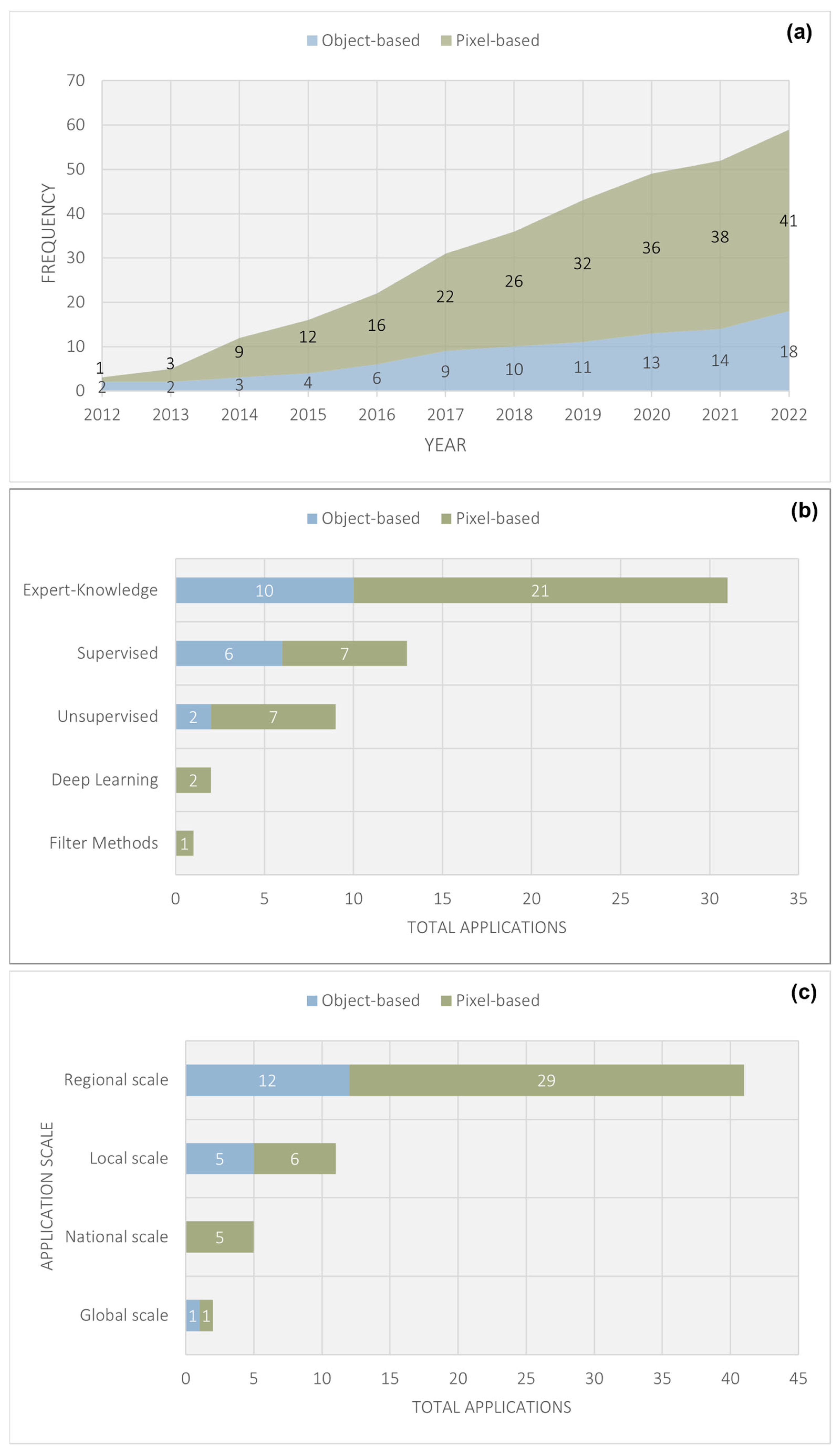

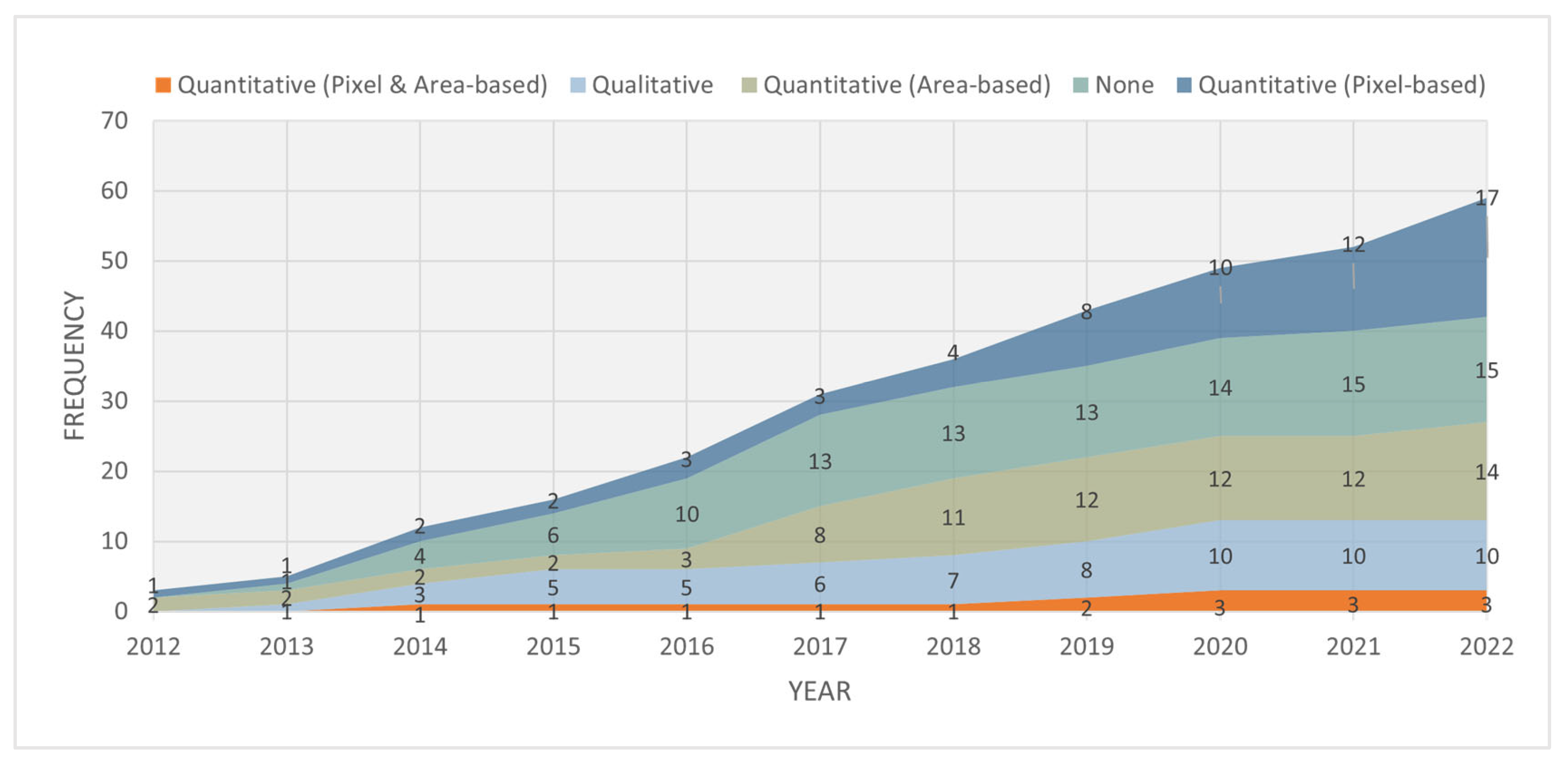


| Number | Research Questions (RQ) | Motivation |
|---|---|---|
| RQ1 | Where has landform classification been conducted? | To identify the geographical distribution of landform classification studies. |
| RQ2 | What datasets have been used to classify landforms? | To determine the data inputs commonly used to classify landforms. |
| RQ3 | How are landforms classified? | To identify trends and gaps in data analysis and application, including application scale. |
| RQ4 | How are landform classification analyses validated? | To understand how landform classification accuracy is assessed. |
| Research Questions | Category | Explanation | Source |
|---|---|---|---|
| RQ2 Datasets Used | DEM < 30 m | Digital elevation datasets with a spatial resolution less than 30 m. Considered as very high-resolution DEM data. | |
| DEM = 30 m | Digital elevation datasets with a spatial resolution of 30 m. Considered as high-resolution DEM data. | ||
| DEM > 30 m | Digital elevation datasets with a spatial resolution greater than 30 m. Considered as moderate to coarse resolution DEM data. | ||
| Laser | Any elevation dataset derived from active laser sensors, including airborne Light Detection and Ranging (LiDAR) and Terrestrial laser scanners. | ||
| Digital Imagery | Any panchromatic, multispectral or hyperspectral datasets captured using digital sensors. | ||
| GPS measurements | Elevation datasets derived from in-field Global Positioning System (GPS) measurements. | ||
| Analogue | Any hardcopy maps or imagery (including any images developed using film photography). | ||
| RQ2 DEM Source | ALOS DEM | Elevation data obtained from the Advanced Land Observing Satellite (ALOS). | |
| ASTER GDEM | Elevation data obtained from the Terra Advanced Spaceborne Thermal Emission and Reflection Radiometer (ASTER). | ||
| Other | Any elevation datasets specifically created for the study area or sourced from local or national government authorities or private companies. Includes datasets created using data such as laser scanning, GPS measurements, etc. | ||
| STRM DEM | Elevation data obtained from the Shuttle Radar Topography Mission (SRTM). | ||
| TanDEM-X | Elevation data obtained from the TanDEM-X interferometric Synthetic Aperture Radar (SAR) satellite mission. | ||
| USGS | Any elevation datasets obtained from the U.S. Geological Survey (USGS), including the Global Multi-resolution Terrain Elevation Dataset (GMTED). | ||
| RQ3 Application Scale | Local | Studies conducted on a relatively small area such as a town, city, village, ward or suburb. | |
| Regional | Studies conducted at a municipal, district, state or provincial level. | ||
| National | Studies conducted across the vast majority of a country’s extent. | ||
| Global | Studies conducted across international borders and comprising the majority of the Earth’s landmass. | ||
| RQ3 Applications | Gravity-controlled processes | Studies relating to gravity-controlled processes, e.g., runoff, erosion and mass movements. Includes disciplines such as hydrology and land degradation. | [3] |
| Geomorphological | Includes both general (detection of simple morphometric features, e.g., peaks, ridges and planes) and specific (detection of discrete features, e.g., sand dunes and alluvial fans) geomorphometry. | [3,6] | |
| Soil mapping | Studies that have employed landforms for digital soil mapping. | [20] | |
| Radiative applications | Use of landforms for computing viewsheds and visibility analysis | [3] | |
| RQ3 Analysis Unit | Pixel | Any approach where DEM and/or image cells/pixels are used as input for classification. | [3,10] |
| Objects | Any approach where neighboring cells with similar features are segmented into regions, objects, areal features or segments before classification. | ||
| RQ3 Methods | Deep Learning | Any application of a deep neural network. | |
| Expert-Knowledge | Any rule-based classification, fuzzy-logic approach or application of pre-existing software tools. | [6,10,21] | |
| Filter Methods | Any method that employs windows, kernels or neighborhoods to analyze pixels and falls outside traditional expert-knowledge approaches. | ||
| Manual Digitizing | Any classification/identification of landforms that were purely user-driven. | ||
| Supervised | Any classification approach that required user-defined training/labeled data. | ||
| Unsupervised | Any clustering approaches or classifications done using unlabeled data. | ||
| RQ4 Validation Techniques | Qualitative | Visual assessment of results. | [22,23] |
| Quantitative (Pixel-based) | An accuracy metric based on a validation dataset comprising image pixels. | [24,25] | |
| Quantitative (Area-based) | An accuracy metric based on a validation dataset comprising image objects or a comparison based on area measurements. | [25,26] | |
| Quantitative (Pixel & Area-based) | A multi-facet validation approach comprising both Quantitative (Pixel-based) and Quantitative (Area-based) metrics. | ||
| None | No validation of results is reported. |
| Validation Process | Total Applications |
|---|---|
| Quantitative (Pixel-based) | 17 |
| None | 15 |
| Quantitative (Area-based) | 14 |
| Qualitative | 10 |
| Quantitative (Pixel and Area-based) | 3 |
Disclaimer/Publisher’s Note: The statements, opinions and data contained in all publications are solely those of the individual author(s) and contributor(s) and not of MDPI and/or the editor(s). MDPI and/or the editor(s) disclaim responsibility for any injury to people or property resulting from any ideas, methods, instructions or products referred to in the content. |
© 2023 by the authors. Licensee MDPI, Basel, Switzerland. This article is an open access article distributed under the terms and conditions of the Creative Commons Attribution (CC BY) license (https://creativecommons.org/licenses/by/4.0/).
Share and Cite
Mashimbye, Z.E.; Loggenberg, K. A Scoping Review of Landform Classification Using Geospatial Methods. Geomatics 2023, 3, 93-114. https://doi.org/10.3390/geomatics3010005
Mashimbye ZE, Loggenberg K. A Scoping Review of Landform Classification Using Geospatial Methods. Geomatics. 2023; 3(1):93-114. https://doi.org/10.3390/geomatics3010005
Chicago/Turabian StyleMashimbye, Zama Eric, and Kyle Loggenberg. 2023. "A Scoping Review of Landform Classification Using Geospatial Methods" Geomatics 3, no. 1: 93-114. https://doi.org/10.3390/geomatics3010005
APA StyleMashimbye, Z. E., & Loggenberg, K. (2023). A Scoping Review of Landform Classification Using Geospatial Methods. Geomatics, 3(1), 93-114. https://doi.org/10.3390/geomatics3010005


