Article

Wildlife–Vehicle Collisions in South-Central Uganda: Implications for Biodiversity Conservation

by
Gilbert Tayebwa
1,*,
Priscilla Nyadoi
2,3,
Benson Turyasingura
4,
Patrick Engoru
1 and
Adalbert Aine-Omucunguzi
1
1
The International Crane Foundation/Endangered Wildlife Trust Partnership, E-11376 Shady Lane Road, Baraboo, WI 53913, USA
2
Uganda Wildlife Society, Plot 39 Babiiha Avenue, Kololo, Kampala P.O. Box 7422, Uganda
3
Directorate of Graduate Studies Research and Enterprise, Uganda Martyrs University, Kampala P.O. Box 5498, Uganda
4
Department of Environment and Natural Resources, Kabale University, Plot 364 Block 3 Kikungiri Hill, Kabale Municipality, Kabale District, Kabale P.O. Box 317, Uganda
*
Author to whom correspondence should be addressed.
Conservation 2025, 5(2), 26; https://doi.org/10.3390/conservation5020026
Submission received: 24 December 2024 / Revised: 9 May 2025 / Accepted: 20 May 2025 / Published: 29 May 2025

Abstract

:
Vehicle collisions with wild animals are a significant cause of wild animal mortality. This impacts their population and spatiotemporal distribution within the ecosystem. Data on the impact of road kills on wild animals, particularly in the south-central part of Uganda, are not present. This study aimed to investigate the number of species involved in road kills in South-Central Uganda and their spatial and temporal distribution within South-Central Uganda. Three transects, each 40 km in length, were surveyed. In both wet and dry seasons, surveys were conducted monthly in the morning and afternoon from November 2019 through April 2024. The findings showed that 161 wildlife–vehicle accidents were detected within a four-and-a-half-year period, with 178 animal species involved. These incidents belonged to 12 mammals, five reptiles, two amphibians, and 32 avian families. Our study adds to a better understanding of the impact of roads on wildlife in Africa and is an essential starting point regarding conservation efforts to mitigate these effects. It provides a first summary of species that are frequently found as roadkill in this area of south-central Uganda. This acts as a reference point for future studies.

1. Introduction

Roads have made it easier for humans to travel and reach previously unreachable places, which has led to more interactions between automobiles and wildlife [1,2,3]. The effects of roads on the movement of wildlife are multifaceted, though. These interactions frequently lead to collisions between vehicles and wildlife, which jeopardize wildlife populations [2,3,4]. Although certain species may use roadways for relocation, roads serve largely as obstacles that fragment habitats and raise the risk of mortality [5,6,7,8,9]. Wildlife–vehicle collisions are one of the most common causes of wildlife fatalities and a primary global conservation concern [10]. Roadkilled animals are among the most frequent ways in which humans all over the world encounter wildlife, yet they are among the occurrences that researchers have not thoroughly studied [11]. Most of the available information on roadkill is in developed countries. Every year, hundreds of animals are killed by road traffic [12,13]. The global roadkill dataset, compiled from 1971 to 2024 across 54 countries, documents 208,570 roadkill-related incidents involving terrestrial vertebrates. Mammals account for the majority of victims, accounting for 61% of cases, while amphibians represent 21%. Reptiles and birds are affected at rates of 10% and 8%, respectively, with risks associated with their movement behaviors and flight paths [13]. In Africa, antelopes and elephants are among the victims [14,15,16]. However, in North America, roadkill statistics show that deer are frequently mentioned, while animals like foxes and hedgehogs are also observed in Europe, and the effects on animals like cattle and monkeys have been emphasized in Asia [17]. Large animals are a major emphasis of roadkill everywhere [18], including Africa and most of the East African national parks [19,20].
In Africa, few studies on roadkills have been focused on the south of the continent [21]. In the case of East Africa, a few roadkill studies have been undertaken on wildlife in protected areas in countries like Kenya and Tanzania, yet much of East Africa remains under-researched [7,20]. While in Uganda, a case study recorded the death of a chimpanzee, Pan troglodytes schweinfurthii, resulting from a road collision in Bulindi [22].
Animals trying to cross highways frequently result in collisions with vehicles [7]. Additionally, when wildlife tries to cross highways, roadkill events frequently happen, and drivers may not anticipate or respond to rapid animal movements [23]. Roads have a negative impact on animal conservation because they increase death rates, alter routes of motion, and fragment ecosystems, which can result in altered habitat preferences. By causing edge effects, dividing landscapes, and changing microclimatic conditions, road networks can change the selection of habitats [17]. Certain species, like scavengers that eat on roadways, may occasionally be drawn to them because of the food they provide. Roads also contribute to species population isolation and decreased breeding success due to an increase in mortality of some breeding animals [8,24,25,26].
Some studies have noted that human population growth and economic development result in increased vehicle traffic [27]. Areas with more road networks are more productive because road networks make it easier for vehicles to move more quickly and deliver services [28]. This often raises the risk of collisions between vehicles and wildlife in places where highways cross important ecosystems. This is made worse by wildlife’s slow adaptation to shifting traffic patterns [4,29], especially in areas with high biodiversity and few mitigation measures.
Wildlife–vehicle roadkill events are spatially concentrated because wildlife movement is associated with specific habitats, terrain, and neighboring land use types [30]. Roads are vital for human economic growth and commodity movements [9,31]. Wildlife species are drawn to roads for various reasons, for example, the availability of food resources or proximity to fragmented habitats [32]. While this happens, both deliberate and unintended food droppings or waste from passing vehicles are utilized for wildlife because they attract animals such as birds, chimpanzees, and other wildlife, increasing the likelihood of crashes [33]. Animals killed on the road, if fresh, provide easily accessible nutrition for scavengers and predators. Hence the potential for secondary roadkills increases, as scavengers and predators may feed on carcasses [32,34,35].
The most vulnerable animal species populations are not those that are unaffected by road noise or traffic but rather those that move across roads on a regular and seasonal basis to reach areas of habitat or explore along highways [8].
Furthermore, the proximity of roads to essential habitats and human settlements has worsened the issue. This is due to higher traffic volumes and speeds, leading to more frequent collisions [36]. In south-central Uganda, agricultural expansion and road development are changing natural habitats, putting various wildlife species at increased risk of getting hit by vehicles. Roadkill incidents involve rare and common species; however, because rare species stand a higher danger of extinction, much of the conservation effort and research is concentrated on them [37]. Common species have gotten significantly less attention.
There has been an increasing rate of sightings of roadkill incidents in south-central Uganda, but there is a lack of documentation on this issue. This research aimed to fill this gap by documenting the wildlife species involved in roadkill and analyzing their spatial and temporal distribution across three road transects in Kiruhura, Lyantonde, and Lwengo districts. The study focused on birds, mammals, amphibians, and reptiles, providing critical insights into how road infrastructure impacts local biodiversity.

2. Materials and Methods
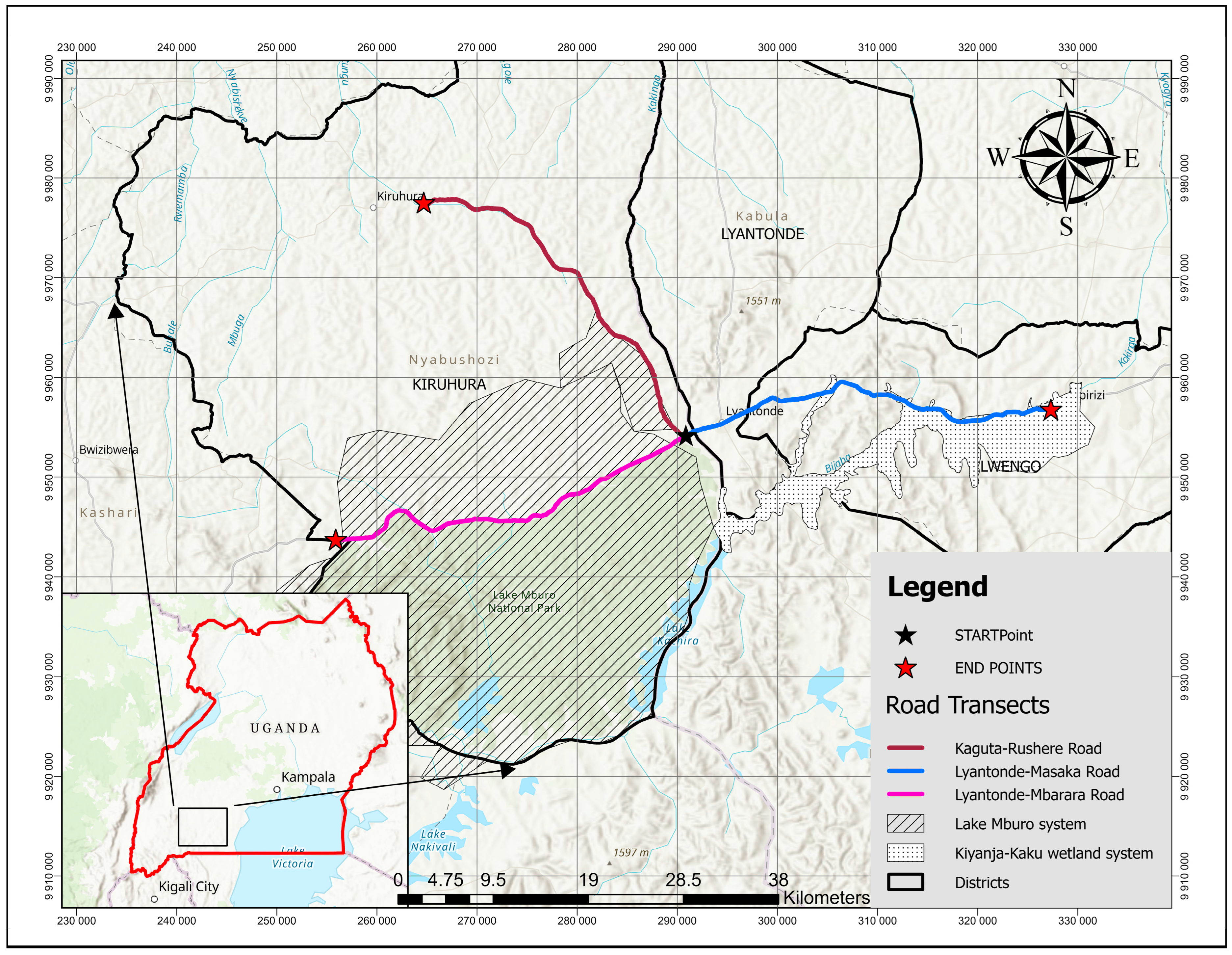
2.1. Study Area

The study was conducted every month between November 2019 and April 2024 on roads passing through three districts of Lwengo, Lyantonde, and Kiruhura (Figure 1). These districts have two essential biodiversity hotspots, the Kiyanja-Kaku wetland and Lake Mburo National Park, vital biodiversity areas in south-central Uganda. The study area is at an altitude of 1266 m above sea level. The study area is located at the coordinates −0.511595°, 30.809217°. Lake Mburo National Park is a Ramsar site and an important bird and biodiversity area; it is home to more than 310 bird species, such as the globally red-listed species of the grey-crowned crane (Balearica regulorum) and Papyrus Gonolek (Laniarius mufumbiri) [38].
Kiyanja-kaku wetland is home to several endangered grey crowned crane populations and a significant number of large animals such as the Sitatunga Tragelaphus spekii, Shoebill Balaeniceps rex, and Hippopotamus Hippopotamus amphibiu [39,40]. This area is mainly covered with grasslands, woodlands, and planted forests (e.g., timber plantations). Croplands include plantations of coffee, bananas, maize, and beans, as well as both seasonal and permanent wetlands, including human settlement areas.
The study area has a bimodal rainfall pattern, which includes two separate wet and dry seasons [41]. These seasons greatly influence natural processes and human activity. Moderate precipitation throughout the brief rainy season, which runs from March to May, promotes the growth of early vegetation and wildlife activities. During this time, there is a longer dry season with minimal precipitation from June to August [39]. Variations in wildlife behavior and habitat use occur as temperatures rise and water supplies become less available. Additionally, this area is a livestock route in Uganda. Higher rainfall throughout the lengthy rainy season, which runs from September to December, increases the risk of localized floods, especially in low-lying wetland areas. Furthermore, January through February is a brief dry season, which is usually hot and dry with the possibility of precipitation.

2.2. Data Collection

Three 40 km long transects were set up using the GIS software Google Earth Pro-(Version 7.3.6). These transects were set up on the roads passing through these districts. These included transect 1 (Kaguta-Rushere Road from Kaguta Road Trading Centre to Kiruhura Town Council in Kiruhura district), transect 2 (Lyantonde-Masaka Road from Kaguta Road Trading Centre to Mbiriizi Town Council and transect 3 (Lyantonde-Mbarara Road from Kaguta Road Trading Centre to Sanga Town Council in Kiruhura district). These roads were chosen based on previous personal records of anecdotal roadkill sightings. Surveys were conducted monthly, and in total, 120 km of roads were surveyed.
Data were collected either in the morning or afternoon hours while driving at a constant speed of less than 15 km/h, with stopovers whenever roadkill was identified [42]. Recordings were taken on the location, date, and time of each roadkill incident, species affected, weather conditions, season of the year, road conditions, and verge grass conditions [42]. We recorded landscape variables such as the distance of the roadkill to the closest natural habitat as an exploratory variable in this study, even though the main goal of the study was to identify the temporal and spatial patterns of collisions between wildlife and vehicles. The distance to the closest natural habitat was recorded to give spatial context for roadkill distributions, particularly in regions where landscape fragmentation may be an issue.
This study defined habitat as a relatively unaltered natural/semi-natural area that may potentially support wildlife activities such as foraging, home range, or breeding purposes. These habitats included forest patches, bushlands, wetlands, and intact grasslands but excluded human-dominated areas like built-up areas or cultivated fields. Using a range finder, we measured the distance from the roadkill location to the nearest habitat. For instances where the road passed through or bordered a habitat, the distance was recorded as 0 m, while for open fields or human-altered areas, the distance to the edge of the nearest natural habitat patch was recorded. We also noted vehicle odometer readings. The transect drives were performed on different days across each of the three highways to capture fluctuations in traffic volume and activity of the wildlife to increase precision and accuracy. This provided a more accurate pattern and trend in the occurrence of road kills in this study.
We only recorded the species we found and did not rely on citizen science information; we also biased our research on fresh road kills to facilitate the identification of the species found. Visual identification of each species was based on physical characteristics such as size, shape, and color, and the species’ unique identification markings were used to identify species [43]. Some species and their conservation status were also determined using standard field guide reference books and online resources.
Where a species was not well identified through online guidebooks and mobile applications such as the iNaturalist and observations.org websites, pictures were taken and shared with expert teams for further identification.
All species encountered were identified using taxonomic levels (class, order, family, common name, and scientific name) and classifying the activity pattern of each species as either nocturnal or diurnal. Each species’ diet was determined based on their primary feeding patterns, including groups such as carnivores (meat eaters), herbivores (plant eaters), omnivores (both meat and plant eaters), frugivores (fruit eaters), insectivores (insect eaters), and piscivores (fish eaters). The IUCN Red List of Threatened Species and the Uganda National Red List document were used to assess the conservation status of each roadkilled species at the global and national levels, and the results ranged from not evaluated to endangered.
The study focused on understanding various species’ taxonomy, behavior, and conservation status. Roadkill specimens were examined to determine the time of death and the nature of the road incident—whether it was injured or killed. The specimens were categorized based on their condition (fresh or decomposed). Roadkill locations were precisely recorded using GPS equipment, and pictures were taken for documentation.
Some animals were found still alive, and these were recorded as injuries; others that were found already dead were recorded as killed. Field teams adopted a real-time reporting process in which injured animals were instantly reported to the Uganda Wildlife Authority (UWA) by phone call. Locations and standardized condition assessments (for example, species, injury severity, and mobility status) were relayed to activate UWA’s specialized rescue units, ensuring ethical compliance by limiting team involvement to observational data gathering rather than physical intervention. Injured individuals were managed completely by UWA-authorized responders, allowing for speedy, expert-led triage while protecting ecological and legal integrity.

2.3. Statistical Data Analysis

All statistical data analyses were performed in R software version 4.4.1 [44]. We utilized non-parametric kernel density analysis to identify roadkill hotspots in south-central Uganda. Kernel density analysis is a clustering method that exposes the pattern of clustering or dispersion trend of road incidents and their hotspot location [45]. This method was chosen for this analysis because it can aid in the identification of clusters or hotspots on the map where warmer colors (yellow and red) represent areas of high roadkill density, suggesting areas with higher roadkill occurrences, and cooler colors (purple and blue) indicate areas of lower roadkill incident density. To analyze the impact of seasons on temporal patterns of roadkill, we classified our data by season of occurrence. Two seasons are experienced in southern Uganda: the dry and rainy seasons. We next utilized chi-square tests to see if there was a significant association between road kills and the specific roads where these events occurred.

3. Results

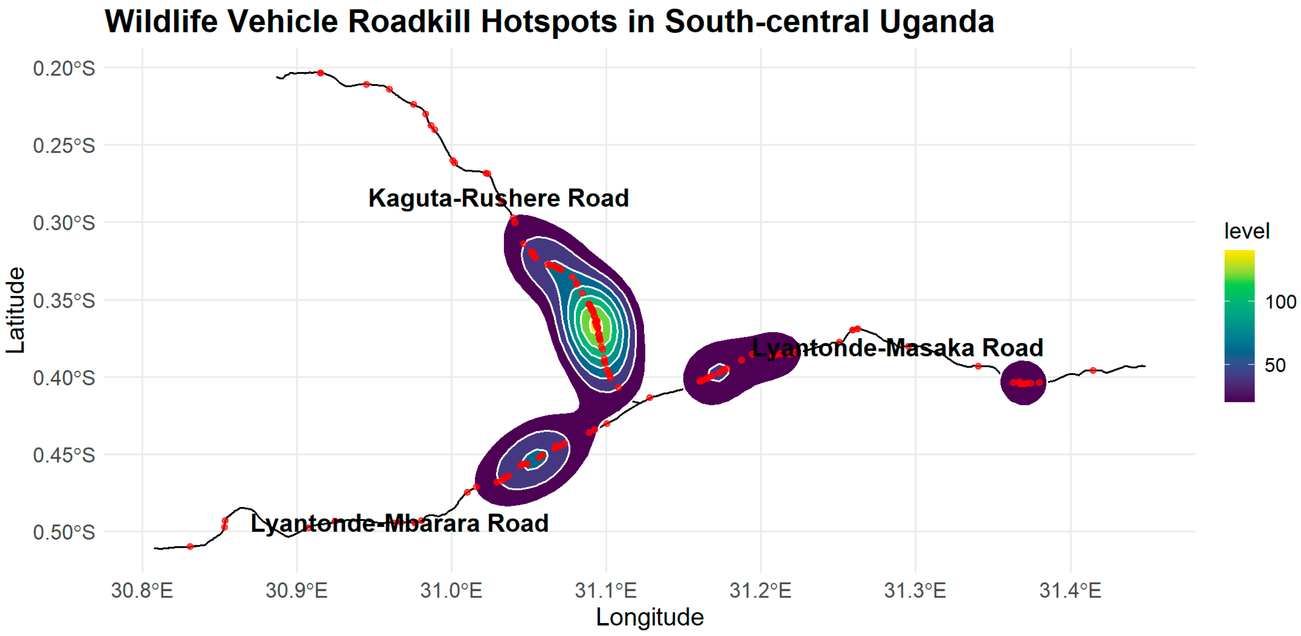
3.1. Spatial and Temporal Distribution of Wildlife–Vehicle Roadkills Among the Three Roads

The Kaguta-Rushere Road showed the most prominent hotspots, suggesting a high concentration of wildlife–vehicle roadkills on this road (Figure 2). Two other noticeable hotspots appear along Lyantonde-Mbarara Road and Lyantonde-Masaka Road, which are smaller than the Kaguta-Rushere road. These zones indicate moderate levels of roadkill density. Lyantonde-Mbarara and Kaguta-Rushere Roads have the most land use/cover, with grasslands and woodlands forming into animal farmlands. These two roads are part of the Lake Mburo National Park system. Most of the roadkills on Kaguta Road were located between Kachenche Trading Centre and Rushere Town Council (Figure 2). In contrast, other major roadkill species on Lyantonde-Mbarara were located between Kaguta Road and Sanga Town Council, and those on Lyantonde-Masaka Road were located on Kiyanja-kaku Wetland in the Kyawagonya Town Council and Katovu-Nkoko areas.
The spatial pattern revealed that roadkill incidents were not evenly distributed across the three roads. Instead, there were clear clusters of incidents at specific locations. In the case of the Lyantonde-Masaka Road, roadkills were more prevalent in areas with wetland patches and agricultural fields as the dominant immediate land use/covers.

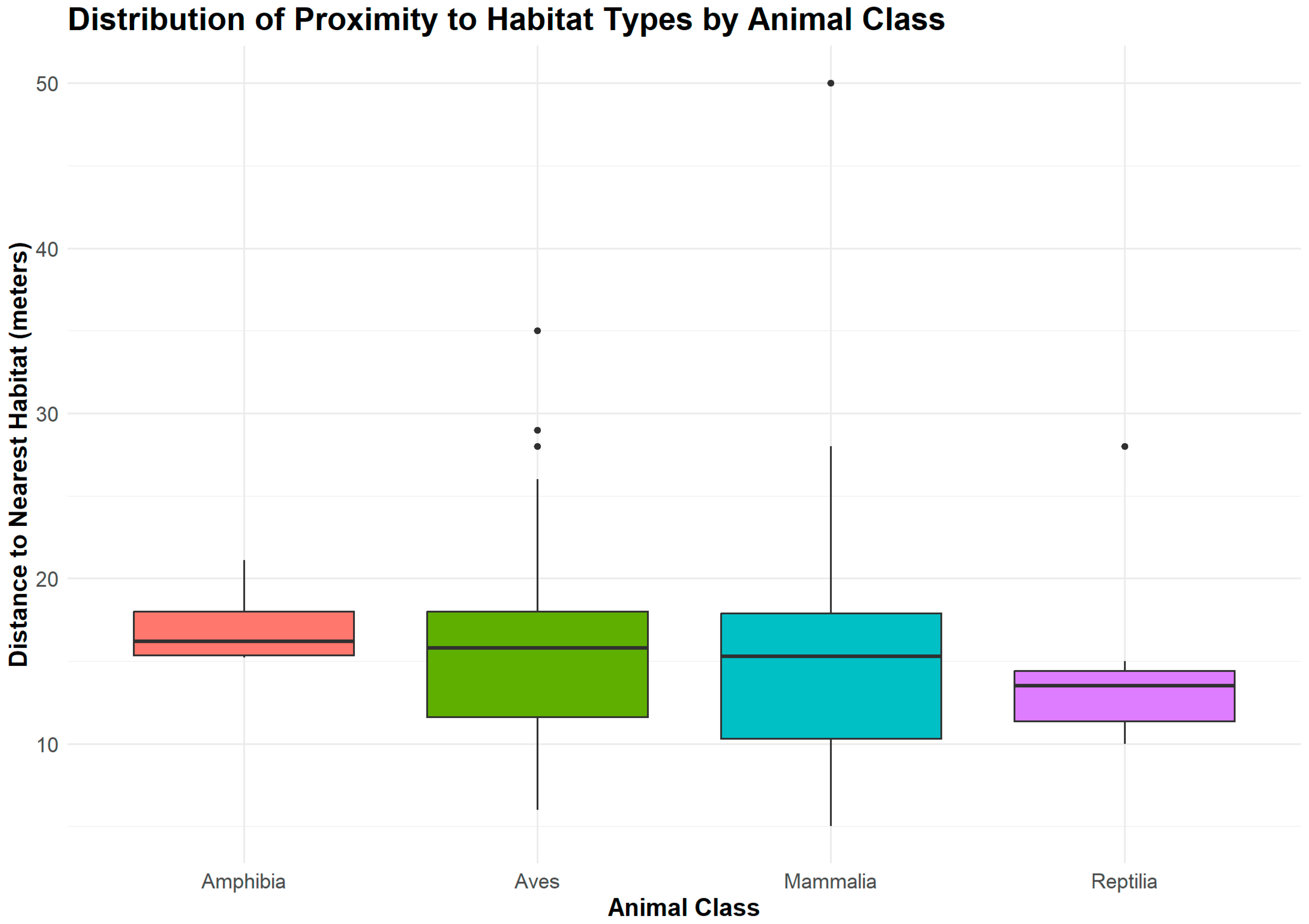
Temporal Distribution with Habitat Types

Distances between various carcasses of animal groups and the nearest habitat to the road showed multiple patterns representing ecological tendencies particular to individual species.
With an average distance of 17.18 m, amphibians were found to have the most considerable mean proximity to the nearest habitat, indicating a more constant distance from habitat margins (Figure 3). On the other hand, with 114 roadkill incidents, the most observed class of birds, the Aves, had a slightly closer mean proximity of 15.38 m. According to this distribution, bird species exhibited various distances but are typically located close to habitat borders. The closest mean proximity to habitat types was recorded by reptiles, at 14.59 m (SD = 5.69 m).
This suggests that reptiles are more closely associated with habitat features near roads, which may be due to their reliance on microhabitats for cover or thermoregulation. Overall, these results show how different taxonomic groupings have different spatial patterns.
The Kruskal–Wallis test was used to determine whether there were any significant variations in the four animal classes regarding their proximity to the nearby habitats. The test revealed no significant difference between the groups, χ2(3, N = 161) = 2.30, p = 0.5117, suggesting that the various animal classes surveyed along the road transects do not differ regarding habitat proximity.
To understand how weather conditions may influence wildlife–vehicle roadkill rates in south-central Uganda, the season (wet, dry) was analyzed for comparison from 2019 to 2024 (Figure 4). The data show some seasonal trends, with birds and mammal animal classes showing a rise in roadkill incidents during the wet season compared to the dry season. Over 75 bird (Aves) incidents were recorded as roadkill during the wet season and 25 during the dry season. Mammals also showed a seasonal trend; in the wet season, there were 25 roadkill incidents, whereas in the dry season, there were 10 incidents.
Although the number of amphibians displayed a rise in roadkill occurrences during the rainy season, the total for both seasons stayed below five incidents. Comparably, less than five roadkill occurrences were recorded for reptiles (Reptilia) each season. There are not many variations between amphibians and reptiles during these two seasons. Most roadkill cases occur during the wet season, with decreased frequency observed in all animal classifications during the dry season. Compared to the dry season, there are more than twice as many instances of roadkill for birds and mammals during the wet season.

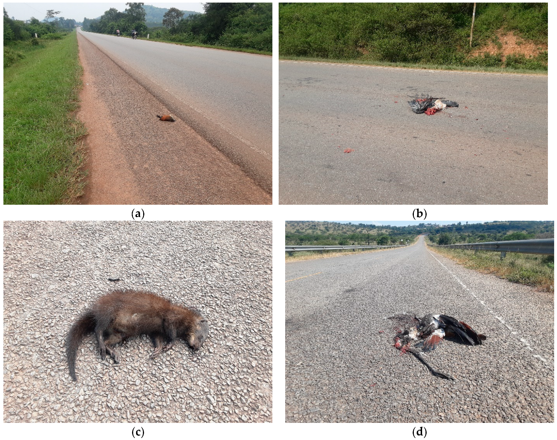
3.2. Wildlife Species Involved in Wildlife–Vehicle Collisions

In all three road transects surveyed, 161 wildlife–vehicle collision incidents were recorded, with 178 individual animals belonging to 3 amphibian families, 32 Aves families, 12 families of mammals, and five reptile families. This indicates that in a single incident, a group of a particular species was recorded at the same point, resulting in one incident. Furthermore, of all the roadkill incidents recorded, 28 were recorded as injuries, with 133 recorded as deaths. Based on their activity patterns, we classified the species involved in each roadkill occurrence into two categories: nocturnal (primarily active at night) and diurnal (foraging and moving actively during the day). The findings show a difference between the number of road kills involving diurnal and nocturnal species, with diurnal species accounting for the majority (91%).
A Pearson’s chi-square test was conducted to examine the relationship between animal classes involved in roadkill incidents and the specific roads on which these incidents occurred. The results indicate that there was no significant association between these two variables. The statistics for the calculated chi-square value suggest that rather than demonstrating a real relationship, the observed differences in road kills across the various animal classes and the three roads are probably the result of chance. No matter which animal class—avian, mammalian, amphibian, or reptilian—the distribution of roadkill incidences does not differ significantly among the studied roads (χ2 = 2.478, df = 6, p = 0.8709).
Most species of roadkill victims fall in the least concern global conservation status, accounting for 170 of the 178 total kills (Table 1). While common species dominate the casualty list, especially the avian class, the existence of endangered and threatened, such as the great snipe (Gallinago media), grey crowned crane (Balearica regulorum) (Figure 5), and red-faced barbet (Lybius rubrifacies) are also important to consider from a conservation standpoint.
The data-deficient animal species category in this region adds an extra element of importance, as these species may be more vulnerable than we realize. Notably, the Kaguta-Rushere Road has the highest number of wildlife–vehicle killings, about 86 individuals, making it a vital region for intervention. However, on a national scale, four species are listed as vulnerable and four as endangered. Five species were also marked as data deficient, and one was listed as not evaluated. The effects of road networks on animal populations in this region cannot be underestimated; collisions with vehicles pose a serious threat to both common and rare animal species.

4. Discussion

4.1. Spatial and Temporal Distribution of Wildlife–Vehicle Roadkills

The fragmentation of essential ecosystems, including grasslands and woods, is strongly related to the prevalence of roadkills along the major hotspots within the three roads. For example, the Kaguta-Rushere and Lyantonde-Mbarara routes are within the critical biodiversity hotspot of Lake Mburo National Park. Roads limit the migration of many animal species, such as birds, reptiles, and small mammals, which depend on these environments as vital ecosystems [8]. The high roadkill rate in these areas shows that animals are crossing roadways in search of resources, such as food or mates, which are becoming increasingly scarce due to habitat alteration. This is similar to findings from other research in other parts of East Africa, where roadkill hotspots were identified in areas with substantial habitat fragmentation [6].
The high number of roadkills, notably between Kachenche Trading Centre and Rushere Town Council, could be related to the disruption of important natural corridors. These corridors, which are necessary for wildlife movement between fragmented habitats, increase the probability of roadkills when roads cross their routes [46]. However, roadkill hotspots in this study involved a broader spectrum of species, suggesting that the scale of the impact might be more profound in the Ugandan context, where larger mammals and birds are involved. Larger mammals and birds, such as raptors, are particularly vulnerable to roadkills because of their behavior, such as foraging near highways or scavenging on carcasses [47]. Similarly, we observed significant roadkill incidents involving slow-moving animals such as the East African potto (Perodicticus ibeanus), and other large birds, like the grey crowned cranes, which are known to forage in open grasslands and fly lower levels across the proximity roads.

4.2. Wildlife Species Involved in Wildlife–Vehicle Collisions

The difference in roadkill between diurnal and nocturnal animals is a significant observation. The higher rate of roadkill among daytime animals in the study area aligns with trends documented in similar international situations. In these cases, the overlap between traffic hours and the activity periods of animals is known to contribute to wildlife–vehicle collisions (WVCs). Diurnal species, which are more active during the day, coincide with peak traffic times, especially on major roads like highways. As a result, the likelihood of collisions between vehicles and animals increases [12,48,49].
While some roadkill studies emphasize that nocturnal species are more vulnerable to roadkill due to poor visibility [45], daylight activity patterns may play a more significant role in roadkill incidents in this region, where there are higher roadkill rates for diurnal species than nocturnal species.
One possible explanation for this variation is our research location’s unique traffic patterns and driving behavior, where drivers do not adhere to speed limits. During the day, traffic volume and speed are typically higher, increasing the probability of collisions with active diurnal species such as birds and mammals [50]. However, some people in this area could be afraid of/dislike some animals like snakes due to their briefs and this causes them to be run over intentionally. The same patterns of intentional collisions due to multiple human beliefs have also been found elsewhere in the world, where wildlife is, at times, intentionally killed on the road due to fear, perceived danger, and other reasons [51,52,53,54]. Additionally, there is a possibility that this kind of habitat supports the movement, breeding, and feeding patterns of diurnal species more, given the fact that the area is in a national park region on the route to the Ugandan capital city, Kampala, an area that receives more vehicles carrying commodities such as food items from rural areas that pass through this study area. Furthermore, diurnal animals may be more inclined to feed along roadsides due to disrupted vegetation habitats and better access to food resources such as grain and cereals from moving vehicles and people [55,56].
The study recorded the presence of some species of global conservation concern, such as Uganda’s national bird, the grey crowned crane, which is listed as endangered both locally and internationally [38,57,58,59]. The primary threats to this species stem from agricultural development and habitat loss due to wetland degradation [60,61,62,63,64]. Additionally, its declining population faces significant risks from vehicle-related deaths, especially in areas where major highways intersect with wetlands in south-central Uganda. Research has shown that large, slow-moving birds, like the grey crowned crane, are particularly vulnerable to car collisions [46,65,66,67].
Additionally, the Great Snipe is a migratory bird that relies on wetland habitats and is classified as vulnerable globally. During migration, individual birds often face road mortality risks when crossing highways between feeding and roosting sites. Studies on migratory and non-migratory birds indicate that shiny road surfaces, poorly maintained roads, and artificial lighting can confuse birds and other animals, increasing the likelihood of collisions. This issue is particularly concerning for nocturnal animals, such as the East African potto (Perodicticus ibeanus), which rely on natural light for navigation.
The red-faced barbet, Lybius rubrifacies, has a small and scattered population primarily found in the Lake Victoria Basin of southcentral and western Uganda [68]. Habitat destruction poses the main threat to this species; however, roadkill mortality also presents an additional risk [68,69,70]. These risks may be particularly high in areas where the species’ range overlaps with expanding road networks in south-central Uganda.
The observed increase in amphibian roadkill incidents during the wet season is consistent with scientifically known amphibian activity patterns. Amphibians are more active in rainy events, especially breeding and migration, increasing their vehicle exposure [71]. Despite this seasonal trend, the number of amphibian roadkill incidents remained low, implying a low amphibian population in the area or that the roads assessed do not pass through essential environments. Similarly, low numbers were found for reptiles, implying that reptiles may have limited numbers in the study area or are less vulnerable to road crossings than other groups.
The increase in bird and mammal roadkills during the wet season, with more than twice as many as during the dry season, suggests that these animals may be more engaged during wet conditions, possibly due to increased foraging opportunities or movements caused by the accessibility of water and food [72]. Wet season conditions for driving, such as limited visibility and slippery surfaces, may also contribute to the rise in deaths. Furthermore, in rainy situations, many species may use highways as convenient routes, increasing the likelihood of incidents [73].

5. Conclusions

Some species identified in this study are of major conservation value, especially those that are considered vulnerable or near threatened in Uganda at the national level and globally. These species’ inclusion in roadkill data indicates a possible threat to their populations, calling for focused mitigation efforts. Most of the species recorded portray a feeding pattern that causes their attraction to roadside surroundings, perhaps because of insects gathering close to lights on runways and improper roadside trash disposal by humans.
The absence of a clear link between the type of road and the frequency of roadkill incidents among various animal groups makes it difficult to implement focused strategies to prevent these incidents in this area. In areas where some types of roads pose higher risks to specific animal groups, measures like wildlife crossings or fencing can be strategically installed to lower mortality rates [74].
Our study suggests that efforts to reduce roadkill should not only target specific roads or types of animals but should instead take a broader approach across the entire road network in this region. This could include implementing measures such as reducing speed limits in areas where wildlife is common, running driver awareness campaigns during the wet season, and installing speed bumps and signage on multiple roads, regardless of the specific wildlife present.

Author Contributions

Conceptualization, G.T., P.N. and B.T.; methodology, G.T.; software, G.T.; validation, P.N.; formal analysis, G.T. and B.T.; investigation, A.A.-O. and P.N.; resources, G.T.; data curation, G.T.; writing—original draft preparation, G.T. and P.N.; writing—review and editing, P.E. and B.T.; visualization, B.T.; supervision, P.E. and P.N.; project administration, G.T. All authors have read and agreed to the published version of the manuscript.

Funding

This research received no external funding.

Institutional Review Board Statement

Not applicable.

Data Availability Statement

Data can be accessed through the https://doi.org/10.17632/pbgpbgk4p2.1, accessed on 23 December 2024.

Acknowledgments

This research would not have been feasible without the International Crane Foundation’s tremendous assistance and contributions. It was successful because they provided tools, such as range finders and vehicles, essential for gathering data. We also thank Babyesiza Waiswa Sadic for the mammal and reptile identification guidance, and Jonathan Onongo, Kibuule Michael, and Judith Mirembe for their knowledge of bird species and commitment to this study. Their assistance in identifying species was crucial in improving our comprehension of roadkill situations.

Conflicts of Interest

The authors declare no conflicts of interest.

References

  1. Laurance, S.G.W.; Stouffer, P.C.; Laurance, W.F. Effects of road clearings on movement patterns of understory rainforest birds in central Amazonia. Conserv. Biol. 2004, 18, 1099–1109. [Google Scholar] [CrossRef]
  2. Morelle, K.; Lehaire, F.; Lejeune, P. Spatio-temporal patterns of wildlife-vehicle collisions in a region with a high-density road network. Nat. Conserv. 2013, 5, 53–73. [Google Scholar] [CrossRef]
  3. Mulero-Pázmány, M.; Rollán, L.; D’Amico, M.; González-Suárez, M. Road orientation affects the impact of roads on wildlife. Wildl. Res. 2022, 50, 39–46. [Google Scholar] [CrossRef]
  4. Van Der Ree, R.; Jaeger, J.A.G.; van der Grift, E.A.; Clevenger, A.P. Effects of roads and traffic on wildlife populations and landscape function: Road ecology is moving toward larger scales. Ecol. Soc. 2011, 16, 48. [Google Scholar] [CrossRef]
  5. Galantinho, A.; Santos, S.; Eufrázio, S.; Silva, C.; Carvalho, F.; Alpizar-Jara, R.; Mira, A. Effects of roads on small-mammal movements: Opportunities and risks of vegetation management on roadsides. J. Environ. Manag. 2022, 316, 115272. [Google Scholar] [CrossRef] [PubMed]
  6. Kioko, J.; Kiffner, C.; Jenkins, N.; Collinson, W.J. Wildlife roadkill patterns on a major highway in Northern Tanzania. Afr. Zool. 2015, 50, 17–22. [Google Scholar] [CrossRef]
  7. Lyamuya, R.D.; Hariohay, K.M.; Masenga, E.H.; Bukombe, J.K.; Mwakalebe, G.G.; Mdaki, M.L.; Nkwabi, A.K.; Fyumagwa, R.D.; Røskaft, E. Magnitude, patterns and composition of wildlife roadkill in the Serengeti ecosystem, northern Tanzania. Afr. Zool. 2021, 56, 173–180. [Google Scholar] [CrossRef]
  8. Dean, W.R.J.; Seymour, C.L.; Joseph, G.S.; Foord, S.H. A review of the impacts of roads on wildlife in semi-arid regions. Diversity 2019, 11, 81. [Google Scholar] [CrossRef]
  9. Collinson, W.; Davies-Mostert, H.; Roxburgh, L.; Van der Ree, R. Status of road ecology research in Africa: Do we understand the impacts of roads, and how to successfully mitigate them? Front. Ecol. Evol. 2019, 7, 479. [Google Scholar] [CrossRef]
  10. Gunson, K.E.; Ireland, D.; Schueler, F. A tool to prioritize high-risk road mortality locations for wetland-forest herpetofauna in southern Ontario, Canada. North-West. J. Zool. 2012, 8, 409–413. [Google Scholar]
  11. Kroll, G. An Environmental History of Roadkill: Road Ecology and the Making of the Permeable Highway. Environ. Hist. 2015, 20, 4–28. [Google Scholar] [CrossRef]
  12. Monge-Nájera, J. Road kills in tropical ecosystems: A review with recommendations for mitigation and for new research. Rev. Biol. Trop. 2018, 66, 722–738. [Google Scholar] [CrossRef]
  13. Grilo, C.; Neves, T.; Bates, J.; le Roux, A.; Medrano-Vizcaíno, P.; Quaranta, M.; Silva, I.; Soanes, K.; Wang, Y. Global Roadkill Data: A dataset on terrestrial vertebrate mortality caused by collision with vehicles. Sci. Data 2025, 12, 505. [Google Scholar] [CrossRef]
  14. McRae, M.; Ammann, K. Road Kill in Cameroon. Nat. Hist. 1997, 106, 36–47, 74–75. [Google Scholar]
  15. Périquet, S.; Roxburgh, L.; Le Roux, A.; Collinson, W.J. Testing the value of citizen science for roadkill studies: A case study from South Africa. Front. Ecol. Evol. 2018, 6, 15. [Google Scholar] [CrossRef]
  16. Grilo, C.; Borda-De-Água, L.; Beja, P.; Goolsby, E.; Soanes, K.; le Roux, A.; Koroleva, E.; Ferreira, F.Z.; Gagné, S.A.; Wang, Y.; et al. Conservation threats from roadkill in the global road network. Glob. Ecol. Biogeogr. 2021, 30, 2200–2210. [Google Scholar] [CrossRef]
  17. Rytwinski, T.; Soanes, K.; Jaeger, J.A.G.; Fahrig, L.; Findlay, C.S.; Houlahan, J.; van der Ree, R.; A van der Grift, E. How Effective Is Road Mitigation at Reducing Road-Kill? A Meta-Analysis. PLoS ONE 2016, 11, e0166941. [Google Scholar] [CrossRef]
  18. Praill, L.C.; Eppley, T.M.; Shanee, S.; Cunneyworth, P.M.K.; Abra, F.D.; Allgas, N.; Al-Razi, H.; Campera, M.; Cheyne, S.M.; Collinson, W.; et al. Road Infrastructure and Primate Conservation: Introducing the Global Primate Roadkill Database. Animals 2023, 13, 1692. [Google Scholar] [CrossRef]
  19. Drews, C. Road kills of animals by public traffic in Mikumi National Park, Tanzania, with notes on baboon mortality. Afr. J. Ecol. 1995, 33, 89–100. [Google Scholar] [CrossRef]
  20. Lala, F.; Chiyo, P.I.; Kanga, E.; Omondi, P.; Ngene, S.; Severud, W.J.; Morris, A.W.; Bump, J. Wildlife roadkill in the Tsavo Ecosystem, Kenya: Identifying hotspots, potential drivers, and affected species. Heliyon 2021, 7, e06364. [Google Scholar] [CrossRef]
  21. Mkhohlwa, M.N. Assessment of Roadkills in Hluhluwe-Imfolozi Park, KwaZulu-Natal, South Africa. Bachelor’s Thesis, University of KwaZulu-Natal, Durban, South Africa, 2017. [Google Scholar]
  22. McLennan, M.R.; Asiimwe, C. Cars kill chimpanzees: Case report of a wild chimpanzee killed on a road at Bulindi, Uganda. Primates 2016, 57, 377–388. [Google Scholar] [CrossRef] [PubMed]
  23. Magnus, Z.; Kriwoken, L.; Mooney, N.J.; Jones, M.E. Reducing the Incidence of Wildlife Roadkill: Improving the Visitor Experience in Tasmania; CRC Sustainable Tourism Technical Report; CRC for Sustainable Tourism: Gold Coast, Australia, 2004. [Google Scholar]
  24. Glista, D.J.; DeVault, T.L.; DeWoody, J.A. A review of mitigation measures for reducing wildlife mortality on roadways. Landsc. Urban Plan. 2009, 91, 1–7. [Google Scholar] [CrossRef]
  25. Garrah, E.; Danby, R.K.; Eberhardt, E.; Cunnington, G.M.; Mitchell, S. Hot Spots and Hot Times: Wildlife Road Mortality in a Regional Conservation Corridor. Environ. Manag. 2015, 56, 874–889. [Google Scholar] [CrossRef]
  26. Bennett, V.J. Effects of Road Density and Pattern on the Conservation of Species and Biodiversity. Curr. Landsc. Ecol. Rep. 2017, 2, 1–11. [Google Scholar] [CrossRef]
  27. Krief, S.; Iglesias-González, A.; Appenzeller, B.M.R.; Okimat, J.P.; Fini, J.-B.; Demeneix, B.; Vaslin-Reimann, S.; Lardy-Fontan, S.; Guma, N.; Spirhanzlova, P. Road impact in a protected area with rich biodiversity: The case of the Sebitoli road in Kibale National Park, Uganda. Environ. Sci. Pollut. Res. 2020, 27, 27914–27925. [Google Scholar] [CrossRef]
  28. Gerritse, M.; Arribas-Bel, D. Concrete agglomeration benefits: Do roads improve urban connections or just attract more people? Reg. Stud. 2018, 52, 1134–1149. [Google Scholar] [CrossRef]
  29. Silva, I.; Crane, M.; Savini, T. The road less traveled: Addressing reproducibility and conservation priorities of wildlife-vehicle collision studies in tropical and subtropical regions. Glob. Ecol. Conserv. 2021, 27, e01584. [Google Scholar] [CrossRef]
  30. Clevenger, A.P.; Chruszcz, B.; Gunson, K.E. Spatial patterns and factors influencing small vertebrate fauna road-kill aggregations. Biol. Conserv. 2003, 109, 15–26. [Google Scholar] [CrossRef]
  31. Manda, M.I.; Dhaou, S.B. Responding to the challenges and opportunities in the 4th industrial revolution in developing countries. In Proceedings of the 12th International Conference on Theory and Practice of Electronic Governance, New York, NY, USA, 3–5 April 2019; Part F148155. pp. 244–253. [Google Scholar] [CrossRef]
  32. Lester, D. Effective wildlife roadkill mitigation. J. Traffic Transp. Eng. 2015, 3, 42–51. [Google Scholar] [CrossRef]
  33. Cibot, M.; Bortolamiol, S.; Seguya, A.; Krief, S. Chimpanzees facing a dangerous situation: A high-traffic asphalted road in the sebitoli area of kibale national park, Uganda. Am. J. Primatol. 2015, 77, 890–900. [Google Scholar] [CrossRef]
  34. Schwartz, A.L.W.; Williams, H.F.; Chadwick, E.; Thomas, R.J.; Perkins, S.E. Roadkill scavenging behaviour in an urban environment. J. Urban Ecol. 2018, 4, juy006. [Google Scholar] [CrossRef]
  35. Peisley, R.K.; Saunders, M.E.; Robinson, W.A.; Luck, G.W. The role of avian scavengers in the breakdown of carcasses in pastoral landscapes. Emu-Austral Ornithol. 2017, 117, 68–77. [Google Scholar] [CrossRef]
  36. Ashley, E.P.; Robinson, J.T. Road mortality of amphibians, reptiles and other wildlife on the Long Point Causeway, Lake Erie, Ontario. Can. Field Nat. 1996, 110, 403–412. [Google Scholar] [CrossRef]
  37. Inger, R.; Gregory, R.; Duffy, J.P.; Stott, I.; Voříšek, P.; Gaston, K.J. Common European birds are declining rapidly while less abundant species’ numbers are rising. Ecol. Lett. 2015, 18, 28–36. [Google Scholar] [CrossRef] [PubMed]
  38. BirdLife International. BirdLife International: Important Bird Area Factsheet. 2023. Available online: https://datazone.birdlife.org/country/factsheet/uganda (accessed on 19 May 2025).
  39. ICF. MWE Kiyanja-Kaku Wetland Community–Based Wetland Management Plan (2021–2030); ICF: Kampala, Uganda, 2021. [Google Scholar]
  40. Byaruhanga, A. Conservation of Nabajjuzi Swamp, Uganda. Whitley Fund for Nature-Whitley Award. Available online: https://whitleyaward.org/winners/birdlife-conservation-uganda/ (accessed on 12 March 2022).
  41. Namulema-Mary, J. The Relevance of Wetland Economic Valuation in Uganda Acase Study of Kiyanja-Kaku Wetland in Lwengo District-Central Uganda. In Proceedings of the EGUGA, Vienna, Austria, 17–22 April 2016; 2016; p. EPSC2016-303. Available online: https://ui.adsabs.harvard.edu/abs/2016EGUGA..18..303N/abstract (accessed on 25 October 2021).
  42. Collinson, W.J.; Parker, D.M.; Bernard, R.T.F.; Reilly, B.K.; Davies-Mostert, H.T. Wildlife road traffic accidents: A standardized protocol for counting flattened fauna. Ecol. Evol. 2014, 4, 3060–3071. [Google Scholar] [CrossRef] [PubMed]
  43. Shilling, F.; Perkins, S.E.; Collinson, W. Wildlife/Roadkill Observation and Reporting Systems. In Handbook of Road Ecology; John Wiley & Sons, Ltd.: Hoboken, NJ, USA, 2015; pp. 492–501. [Google Scholar] [CrossRef]
  44. R Core Team. R: The R Project for Statistical Computing. Available online: https://www.r-project.org/ (accessed on 20 December 2024).
  45. Kazemi, V.D.; Jafari, H.; Yavari, A. Spatio-Temporal Patterns of Wildlife Road Mortality in Golestan National Park-North East of Iran. Open J. Ecol. 2016, 6, 312–324. [Google Scholar] [CrossRef]
  46. Filius, J.; van der Hoek, Y.; Jarrín-V, P.; van Hooft, P. Wildlife roadkill patterns in a fragmented landscape of the Western Amazon. Ecol. Evol. 2020, 10, 6623–6635. [Google Scholar] [CrossRef]
  47. Dean, W.; Milton, S. The importance of roads and road verges for raptors and crows in the Succulent and Nama-Karoo, South Africa. Ostrich-J. Afr. Ornithol. 2003, 74, 181–186. [Google Scholar] [CrossRef]
  48. Sadleir, R.M.F.S.; Linklater, W.L. Annual and seasonal patterns in wildlife road-kill and their relationship with traffic density. N. Z. J. Zool. 2016, 43, 275–291. [Google Scholar] [CrossRef]
  49. Bakaloudis, D.E.; Bontzorlos, V.A.; Kotsonas, E. Wildlife mortality on roads crossing a protected area: The case of Dadia-Lefkimi-Soufli National Park in north-eastern Greece. J. Nat. Conserv. 2023, 74, 126443. [Google Scholar] [CrossRef]
  50. Rendall, A.R.; Webb, V.; Sutherland, D.R.; White, J.G.; Renwick, L.; Cooke, R. Where wildlife and traffic collide: Roadkill rates change through time in a wildlife-tourism hotspot. Glob. Ecol. Conserv. 2021, 27, e01530. [Google Scholar] [CrossRef]
  51. Beckmann, C.; Shine, R. Do drivers intentionally target wildlife on roads? Austral Ecol. 2012, 37, 629–632. [Google Scholar] [CrossRef]
  52. Ashley, E.P.; Kosloski, A.; Petrie, S.A. Incidence of intentional vehicle–reptile collisions. Hum. Dimens. Wildl. 2007, 12, 137–143. [Google Scholar] [CrossRef]
  53. Crawford, B.A.; Andrews, K.M. Drivers’ attitudes toward wildlife-vehicle collisions with reptiles and other taxa. Anim. Conserv. 2016, 19, 444–450. [Google Scholar] [CrossRef]
  54. Langley, W.M.; Lipps, H.W.; Theis, J.F. Responses of Kansas Motorists to Snake Models on a Rural Highway. Trans. Kans. Acad. Sci. 1989, 92, 43. [Google Scholar] [CrossRef]
  55. Cirino, D.W.; Lupinetti-Cunha, A.; Freitas, C.H.; de Freitas, S.R. Do the roadkills of different mammal species respond the same way to habitat and matrix? Nat. Conserv. 2022, 47, 65–85. [Google Scholar] [CrossRef]
  56. Samson, A.; Ramakrishnan, B.; Veeramani, A.; Santhoshkumar, P.; Karthick, S.; Sivasubramanian, G.; Ilakkia, M.; Chitheena, A.; Princy, J.L.; Ravi, P. Effect of vehicular traffic on wild animals in Sigur Plateau, Tamil Nadu, India. J. Threat. Taxa 2016, 8, 9182–9189. [Google Scholar] [CrossRef]
  57. WCS. Nationally Threatened Species for Uganda; WCS: Kampala, Uganda, 2016. [Google Scholar]
  58. BirdLife International. Uganda—BirdLife Country Profile. Available online: https://datazone.birdlife.org/country/uganda (accessed on 25 October 2024).
  59. BirdLife International. Grey Crowned Crane (Balearica Regulorum)—BirdLife Species Factsheet. BirdLife International-Species Factsheet: Balearica Regulorum. Available online: http://datazone.birdlife.org/species/factsheet/grey-crowned-crane-balearica-regulorum/text (accessed on 25 October 2021).
  60. Morrison, K.; AEWA Grey Crowned-Crane International Working Group. International Single Species Action Plan for the Conservation of the Grey Crowned Crane. In Proceedings of the 6th Session of the Meeting of the Partie, Bonn, Germany, 9–14 November 2015. [Google Scholar]
  61. Austin, J.E.; Morrison, K.; Harris, J. Cranes and Agriculture: A Global Guide for Sharing the Landscape; International Crane Foundation: Baraboo, WI, USA, 2018; Available online: https://www.researchgate.net/publication/328676776_Cranes_and_Agriculture_A_Global_Guide_for_Sharing_the_Landscape (accessed on 25 October 2021).
  62. Wamiti, W.; Gichuki, N.; Sigana, D.; Njoroge, P.; Morrison, K.; Ndung’u, G.; Rubalcaba, J. Water depth, vegetation height and water edge distance are critical in nest-site selection for Grey Crowned Crane at Lake Ol’ Bolossat, Kenya. Authorea Prepr. 2020. [Google Scholar] [CrossRef]
  63. Morrison, K.; Dodman, T.; Scott, A.; Shanungu, G.; Smallie, J.; Versveld, W. Species review: Grey crowned crane (Balearica regulorum). In Crane Conservation Strategy; International Crane Foundation: Baraboo, WI, USA, 2019; pp. 261–271. [Google Scholar]
  64. Smith, T.; Page-Nicholson, S.; Morrison, K.; Gibbons, B.; Jones, M.G.; van Niekerk, M.; Botha, B.; Oliver, K.; McCann, K.; Roxburgh, L. The African Crane Database (1978–2014): Records of three threatened crane species (Family: Gruidae) from southern and eastern Africa. Biodivers. Data J. 2016, 4, e9794. [Google Scholar] [CrossRef] [PubMed]
  65. Denneboom, D.; Bar-Massada, A.; Shwartz, A. Wildlife mortality risk posed by high and low traffic roads. Conserv. Biol. 2024, 38, e14159. [Google Scholar] [CrossRef] [PubMed]
  66. Wiacek, J.; Polak, M.; Kucharczyk, M.; Bohatkiewicz, J. The influence of road traffic on birds during autumn period: Implications for planning and management of road network. Landsc. Urban Plan. 2015, 134, 76–82. [Google Scholar] [CrossRef]
  67. Duncan, P.; Kaplan, G. Human-Caused High Direct Mortality in Birds: Unsustainable Trends and Ameliorative Actions. Animals 2024, 15, 73. [Google Scholar] [CrossRef] [PubMed]
  68. Red-Faced Barbet (Lybius Rubrifacies) · iNaturalist. Available online: https://www.inaturalist.org/taxa/117164-Lybius-rubrifacies (accessed on 25 March 2025).
  69. Short, L.L.; Horne, J.F.M. Red-faced Barbet (Lybius rubrifacies), version 1.0. In Birds of the World; Cornell Lab of Ornithology: Ithaca, NY, USA, 2020. [Google Scholar] [CrossRef]
  70. BirdLife International. Lybius rubrifacies. IUCN Red List. Threat. Species 2016, 2016, e.T22681837A92922394. [Google Scholar] [CrossRef]
  71. Anđelković, M.; Bogdanović, N. Amphibian and Reptile road mortality in special nature reserve Obedska Bara, Serbia. Animals 2022, 12, 561. [Google Scholar] [CrossRef]
  72. Santos, R.; Shimabukuro, A.; Taili, I.; Muriel, R.; Lupinetti-Cunha, A.; Freitas, S.R.; Calabuig, C. Mammalian Roadkill in a Semi-Arid Region of Brazil: Species, Landscape Patterns, Seasonality, and Hotspots. Diversity 2023, 15, 780. [Google Scholar] [CrossRef]
  73. Coffin, A.W.; Ouren, D.S.; Bettez, N.D.; Borda-de-Água, L.; Daniels, A.E.; Grilo, C.; Jaeger, J.A.G.; Navarro, L.M.; Preisler, H.K.; Rauschert, E.S.J. The Ecology of Rural Roads: Effects, Management, and Research; Issues in Ecology, Report No. 23; Ecological Society of America: Washington, DC, USA, 2021; pp. 1–30. [Google Scholar]
  74. Soanes, K.; Rytwinski, T.; Fahrig, L.; Huijser, M.P.; Jaeger, J.A.G.; Teixeira, F.Z.; van der Ree, R.; van der Grift, E.A. Do wildlife crossing structures mitigate the barrier effect of roads on animal movement? A global assessment. J. Appl. Ecol. 2024, 61, 417–430. [Google Scholar] [CrossRef]
Figure 1. Map of the study area in south-central Uganda.
Conservation 05 00026 g001
Figure 2. Distribution of roadkill hotspots along the three roads in south-central Uganda.
Conservation 05 00026 g002
Figure 3. Comparison of the distance of roadkill incidents to the nearest habitat by different animal class categories.
Conservation 05 00026 g003
Figure 4. Seasonal distribution of roadkill incidents per animal classes recorded.
Conservation 05 00026 g004
Figure 5. Sample of specimens of animals found killed on the three roads in the study area. (a) white-browed coucal at road peripheral, (b) a killed marabou stork in the middle of the road, (c) marsh mongoose killed on Lyantonde-Masaka Road, (d) endangered grey crowned crane killed on Kaguta-Rushere Road.
Conservation 05 00026 g005
Table 1. IUCN conservation status of species distribution along the three roads covered in the study area.
Conservation Status by RoadDDENLCNTNETotal
Kaguta-Rushere Road 1832 86
Amphibians 3 3
Aves 1552 58
Mammals 21 21
Reptiles 4 4
Lyantonde-Masaka Road1145 148
Amphibians 1 1
Aves 131 32
Mammals1 11 12
Reptiles 2 13
Lyantonde-Mbarara Road 422 44
Aves 312 33
Mammals 10 10
Reptiles 1 1
Total1217041178
DD = data deficient, EN = endangered, LC = least concern, NT = near threatened, NE = not evaluated.
Disclaimer/Publisher’s Note: The statements, opinions and data contained in all publications are solely those of the individual author(s) and contributor(s) and not of MDPI and/or the editor(s). MDPI and/or the editor(s) disclaim responsibility for any injury to people or property resulting from any ideas, methods, instructions or products referred to in the content.

