
Using Expert Knowledge to Assess Resistance to Internal Erosion of Levees with Tree Vegetation


Abstract
1. Introduction
2. Materials and Methods
2.1. Internal Erosion and Tree Vegetation: Analysis of the Influence of Tree Vegetation
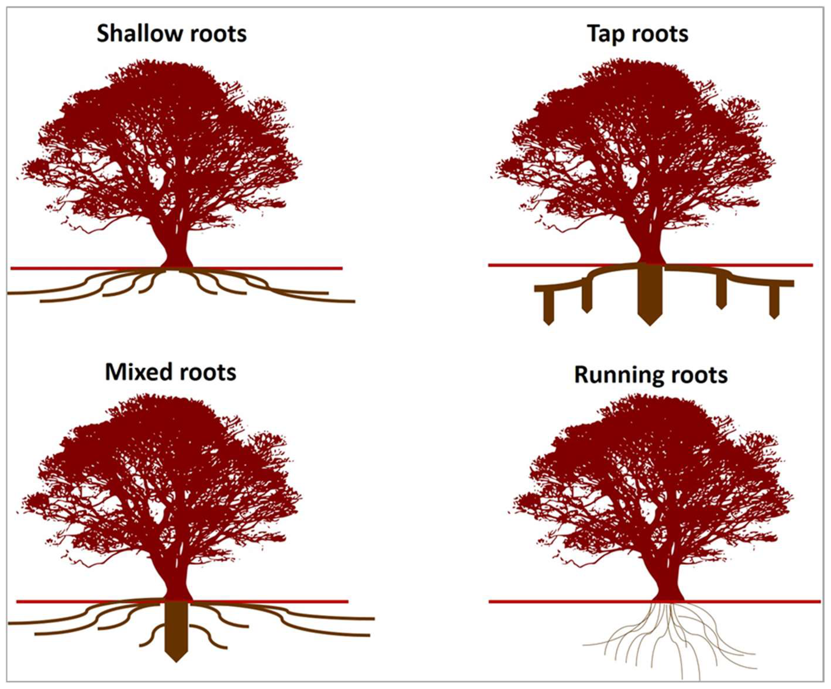
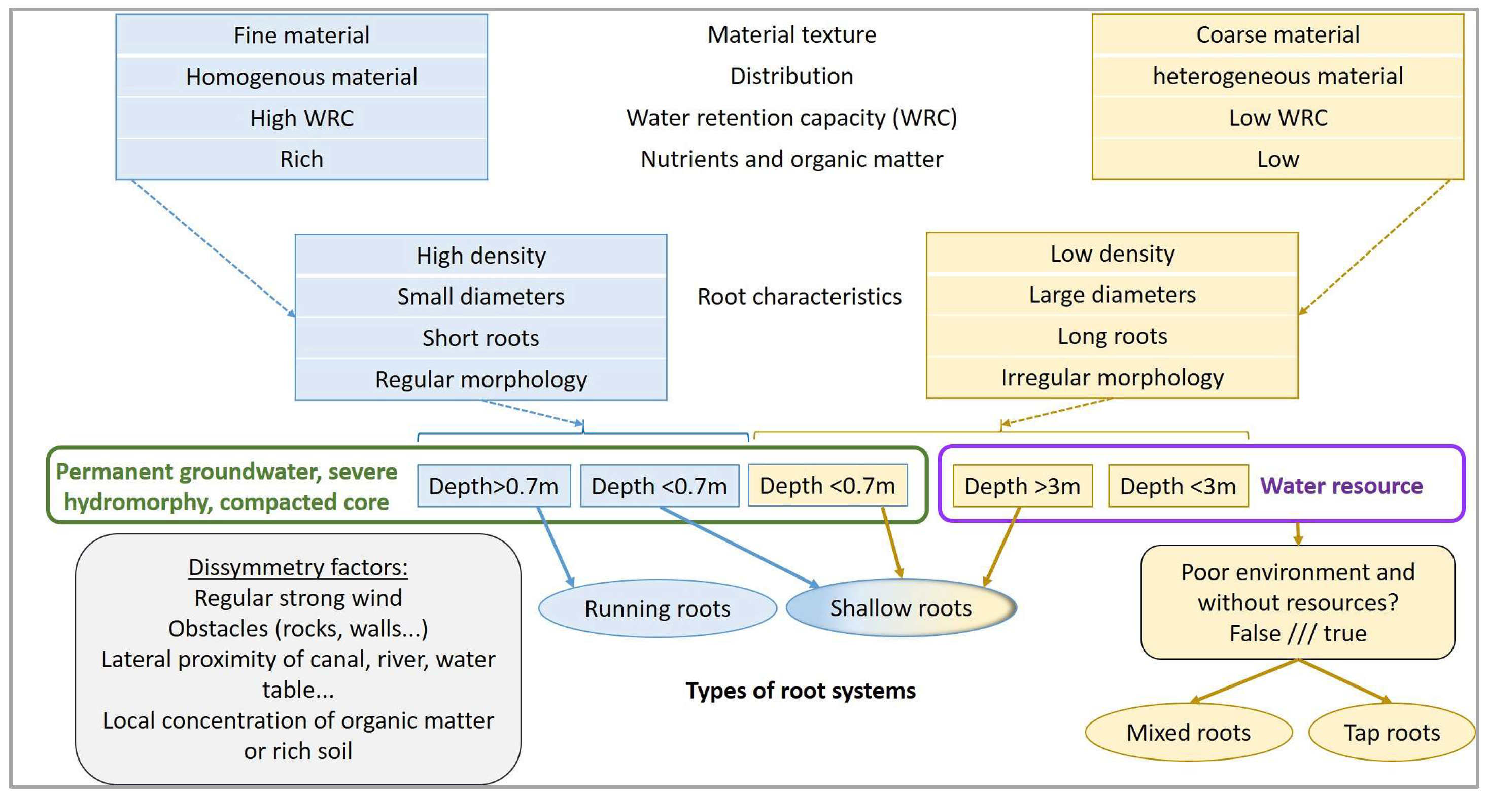
- Shallow roots: long horizontal roots close to the surface of the soil, liable to cross the structure from upstream to downstream and vice versa;
- Tap roots: large vertical roots that can penetrate deep into the earthfill;
- Mixed roots: grouping shallow and tap roots;
- Running roots: numerous roots in all directions, horizontal and vertical, generally of small diameter.
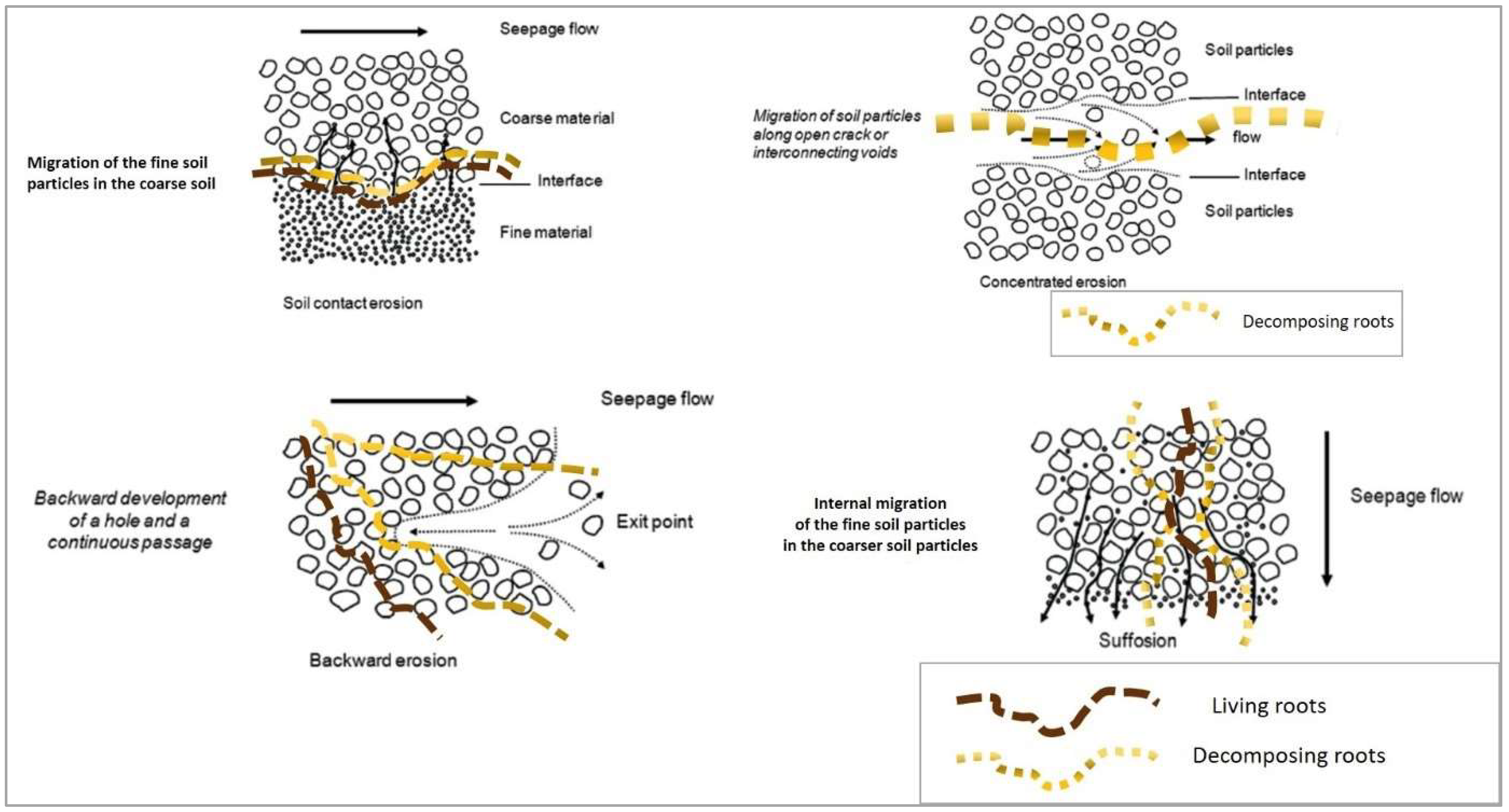
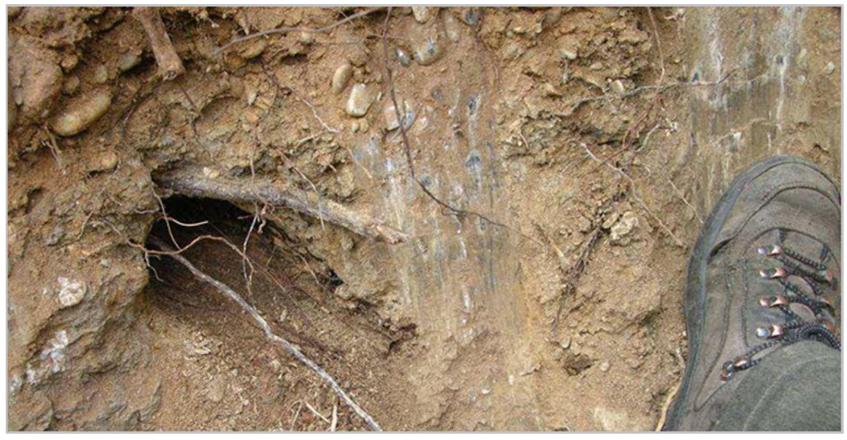
2.1.1. Contact Erosion
2.1.2. Concentrated Erosion
2.1.3. Backward Erosion
2.1.4. Internal Erosion by Suffusion
2.1.5. Synthesis
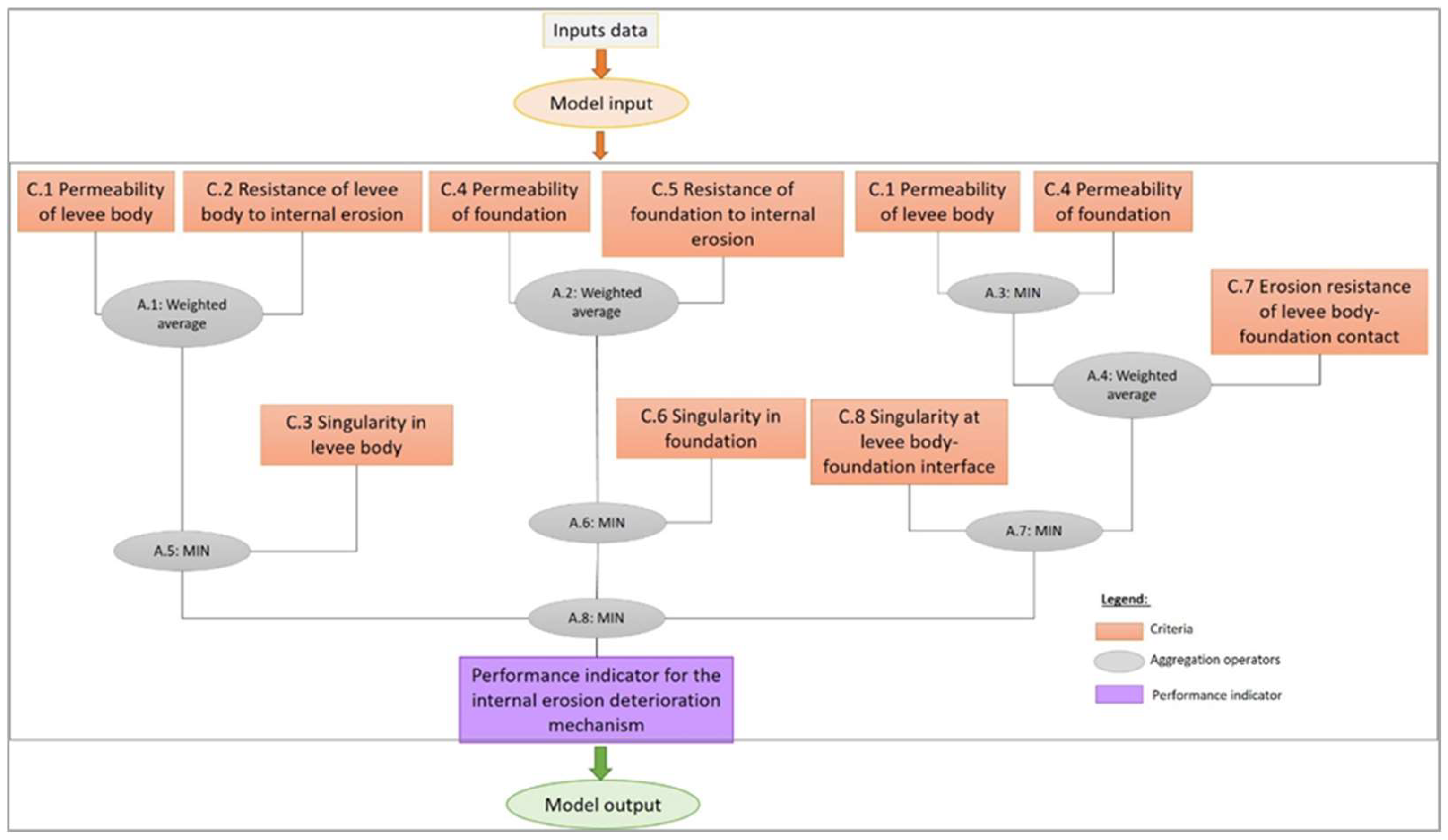
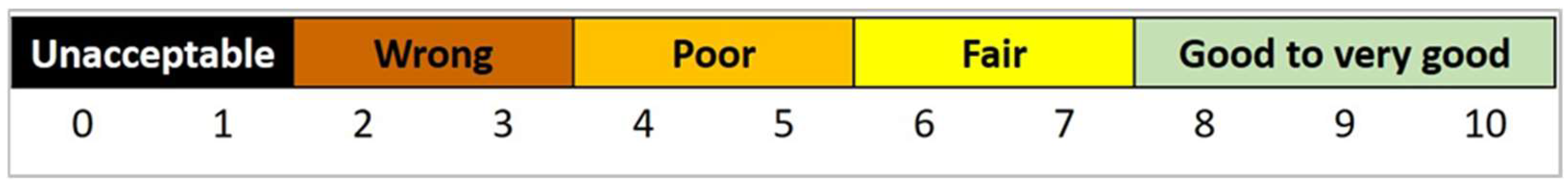
2.2. Knowledge-Based Method for Assessing Performance
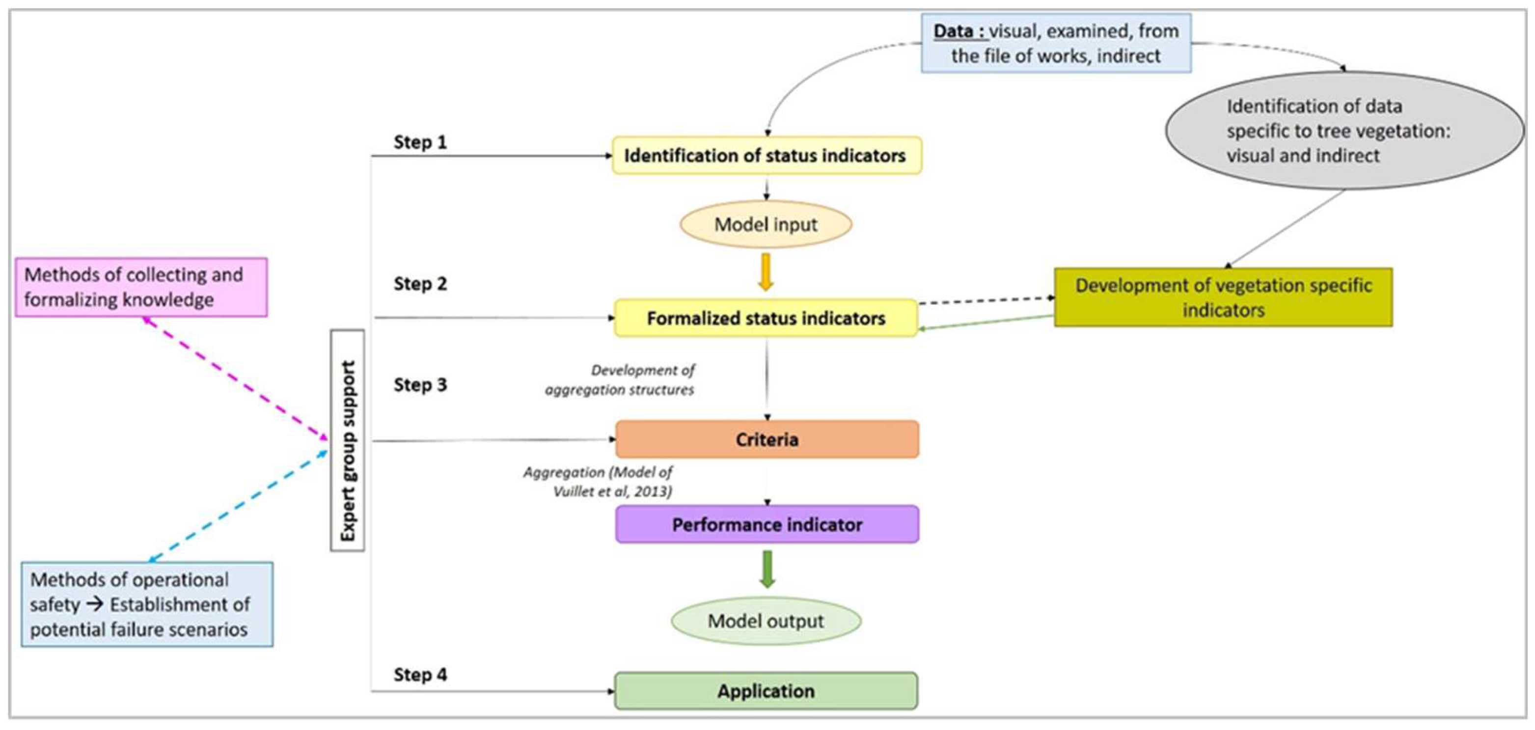
2.2.1. General Framework
- Status indicators (SI.i) comprise the first step in the method. They can be filled in using the following input data: visual observations (e.g., “Leakage, leakage index”), instrument measurements (e.g., “Material permeability”), geotechnical data (e.g., “Sensitivity to internal erosion for the design flood”), the results of hydraulic or mechanical calculations (e.g., “Duration of flood”) or other data derived from design and construction (e.g., “Geometry of levee body”).
- The criteria (C.i) allow assessing the performance of a given function (e.g., “Permeability of levee body”). They are obtained by aggregating the status indicators or are directly assessed by the expert.
- The performance indicator is the output of the method and is obtained by aggregating criteria.
2.2.2. Functional Model for Evaluating the Performance of the Internal Erosion Mechanism
2.2.3. Determination of State Indicators Involved in the Internal Erosion Mechanism Related to Tree Vegetation
3. Results
3.1. Proposition of Method Based on Qualitative Indicators for Levees with Respect to Internal Erosion in the Presence of Tree Vegetation
3.1.1. Identification of Status Indicators
- “Density of individuals” (trees or stumps) for the levee body (SI1.4) and for the foundation (SI4.4);
- “Root volume per individual” for the levee body (SI1.5) and for the foundation (SI4.5);
- “Type of root structure of individuals” for the levee body (SI1.6) and for the foundation (SI4.6);
- “Degree of decomposition of the stump or woody roots of an individual” for the levee body (SI1.7) and for the foundation (SI4.7).
3.1.2. Formalization of Status Indicators Specific to Tree Vegetation
- The geographical zone and thus the type of climate.
- The time of decomposition: It is necessary to know the date of death of the tree. Currently, we have information on the state of decomposition of woody roots after up to 6 years of decomposition for species from semi-continental environments and 4 years of decomposition for species from mountain environments.
- The tree species to be assessed: currently, we have information available on the decomposition of six species (oak, ash, black locust, poplar, larch and Scots pine).
3.1.3. Aggregation of Status Indicators to Obtain Criteria
- The Figure S1 that shows the hierarchical structure of the method,
- Assessment of criterion C.1 “Permeability of levee body” (Figure S2) with the various formalization grids (Tables S1–S7) and truth tables (Figures S4–S8),
- Assessment of criterion C.2 “Resistance of levee body to internal erosion” (Figure S9) with the various formalization grids (Tables S8–S12) and truth tables (Figures S10 and S11),
- Assessment of criterion C.4 “Permeability of foundation” (Figure S12) with the various formalization grids (Tables S13–S19) and truth tables (Figures S13–S18),
- Assessment of criterion C.5 “Resistance of foundation to internal erosion” (Figure S19) with the various formalization grids (Tables S20–S24) and truth tables (Figures S20 and S21),
- Assessment of criterion C.7 “Erosion resistance of levee body-foundation contact” (Figure S22) with the various formalization grids (Tables S25–S27) and truth tables (Figure S23),
- The Figure S24 that shows the diagram of aggregation of criteria used to obtain the performance indicator.
3.2. Application of Performance Assessing Method
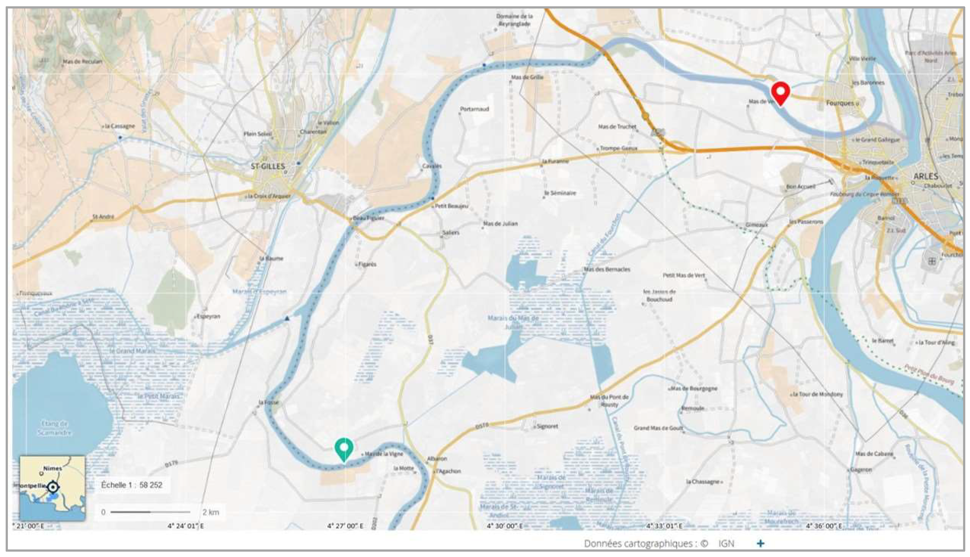
3.2.1. Presentation of the Case Study
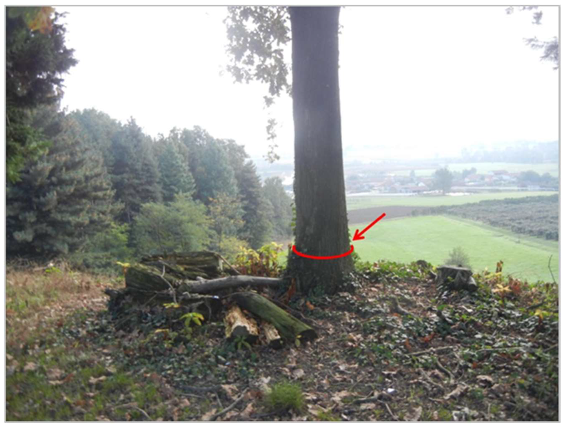
- Segment 1: The heights of the structure on the water side and on the protected side are between 2 and 3 m. The slopes of the levee are 2.5/10 and 3/10 on the water and protected side, respectively. The width of the crest is 4.30 m (Figure 14a). The width between the levee and the low water channel is mostly less than 7 m. The levee overflows during 50-year floods. It is mainly made of clay–silt materials. The tree vegetation is mainly present at the foot of the levee on the water side and on the protected side, although a few individuals can be found in the middle of the slope on the water side. The main species is poplar.
- Segment 2: It has been reinforced and has a crest and berm width of approximately 9 m. The heights of the structure on the water side and on the protected side are about 4 m. The slopes of the two slopes are 3/10. The average distance between the levee and the low flow channel of the Rhone river is more than 50 m. Up to the 100-year flood line, the water line does not overflow and there is a safety margin of 0.50 m. The levee is mainly made of sandy–silt materials. The vegetation is present mainly at the foot of the levee and on the slope on the water side (Figure 14b). There are also a few trees at the foot of the slope, but these have no impact on the structure given the width of the segment. The present trees are mature. In the field, we observed a few cut trees, of which no trace of rejection was noted. The date of felling these trees was not known. The main species is poplar.
3.2.2. Assessment and Aggregation of Status Indicators
3.2.3. Aggregation of Criteria to Obtain the Performance Indicator for the Two Segments
4. Discussion
5. Conclusions
Supplementary Materials
Author Contributions
Funding
Data Availability Statement
Acknowledgments
Conflicts of Interest
Abbreviations
| C.i | Criterion |
| SI.i.i | Status indicator |
| MIN | Minimum |
| TT.i | Truth table |
References
- Girolami, L.; Bonelli, S.; Valois, R.; Chaouch, N.; Burgat, J. On Internal Erosion of the Pervious Foundation of Flood Protection Dikes. Water 2023, 15, 3747. [Google Scholar] [CrossRef]
- Bridle, R. Internal Erosion Mechanics and Risk Estimation Based on ICOLD Bulletin 164; ASCE Publishing: Reston, VA, USA, 2017. [Google Scholar]
- International Commission on Large Dams (ICOLD). Internal Erosion of Existing Dams, Levees and Dikes, and Their Foundations: Case Histories, Investigations, Testing, Remediation and Surveillance; CRC Press: London, UK, 2025. [Google Scholar]
- Curt, C.; Peyras, L.; Boissier, D. A Knowledge Formalization and Aggregation-Based Method for the Assessment of Dam Performance. Comput.-Aided Civ. Infrastruct. Eng. 2010, 25, 171–184. [Google Scholar] [CrossRef]
- Özer, I.E.; van Damme, M.; Jonkman, S.N. Towards an International Levee Performance Database (ILPD) and Its Use for Macro-Scale Analysis of Levee Breaches and Failures. Water 2020, 12, 119. [Google Scholar] [CrossRef]
- CIRIA. The International Levee Handbook; CIRIA: London, UK, 2013. [Google Scholar]
- Rivera-Hernandez, X.A.; Ellithy, G.S.; Vahedifard, F. Integrating Field Monitoring and Numerical Modeling to Evaluate Performance of a Levee under Climatic and Tidal Variations. J. Geotech. Geoenviron. Eng. 2019, 145, 05019009. [Google Scholar] [CrossRef]
- Bambara, G.; Curt, C.; Mériaux, P.; Vennetier, M.; Vanloot, P. Modular assessment of the performance of embankment dams. Eur. J. Environ. Civ. Eng. 2018, 22, 315–337. [Google Scholar] [CrossRef]
- Vuillet, M.; Peyras, L.; Carvajal, C.; Serre, D.; Diab, Y. Levee performance evaluation based on subjective probabilities. Eur. J. Environ. Civ. Eng. 2013, 17, 329–349. [Google Scholar] [CrossRef]
- Akerkar, R.; Sajja, P. Knowledge-Based Systems; Jones & Bartlett Publishers: Burlington, MA, USA, 2009. [Google Scholar]
- Booker, J.M.; McNamara, L.A. Solving black box computation problems using expert knowledge theory and methods. Reliab. Eng. Syst. Saf. 2004, 85, 331–340. [Google Scholar] [CrossRef]
- Shield, F.; Gray, D. Effects of Woody Vegetation on Sandy Levee Integrity. Water Resour. Bulletin. 1992, 28, 917–931. [Google Scholar] [CrossRef]
- Haselsteiner, R.; Kerres, D. The Rehabilitation of Levees with Large Trees by Equivalent Static Systems. In Proceedings of the Symposium on Sustainable Development of Dams and River Basins, New Delhi, India, 24–27 February 2021. [Google Scholar]
- FEMA. Technical Manual for Dam Owners: Impacts of Plants on Earthen Dams (Fema 534/September 2005); Books Express Publishing, US Department of Homeland Security: Washington, DC, USA, 2005. [Google Scholar]
- Laasonen, J. Risk of the trees and stumps to the embankment dam safety. Experimental study. In Proceedings of the International Economic Conference, Sibiu, Romania, 17–18 May 2013. [Google Scholar]
- Martinez Santamaria, J.M.; Fernandez Serrano, R. Geotechnical impact on small earth dams caused by vegetation growth as a result of inadequate maintenance activity. In Dam Maintenance and Rehabilitation II; CRC Press: Boca Raton, FL, USA, 2011; pp. 229–236. [Google Scholar]
- Meriaux, P.; Vennetier, M.; Aigouy, S.; Hoonakker, M.; Zylberblat, M. Diagnosis and management of plant growth on embankment dams and dykes. In Proceedings of the ICOLD, 22nd Conference on Large Dams, Barcelona, Spain, 18–23 June 2006; pp. 1–20. [Google Scholar]
- Zanetti, C.; Vennetier, M.; Mériaux, P.; Provensal, M. Plasticity of tree root system structure in contrasting soil materials and environmental conditions. Plant Soil 2015, 387, 21–35. [Google Scholar] [CrossRef]
- Bambara, G. Evaluation De La Performance Des Ouvrages Hydrauliques En Remblai Soumis À La Présence De Végétation Arborescente. Ph.D. Thesis, Aix-Marseille University, Marseille, France, 2016. [Google Scholar]
- Zanetti, C.; Vennetier, M.; Mériaux, P.; Royet, P.; Provansal, M. Managing woody vegetation on earth dikes: Risks assessment and maintenance solutions. Procedia Environ. Sci. 2011, 9, 196–200. [Google Scholar] [CrossRef]
- Vuillet, M. Élaboration D’un Modèle D’aide à la Décision Probabiliste Pour L’évaluation de la Performance Des Digues Fluviales. Ph.D. Thesis, Paris Est University, Créteil, Val de Marne, France, 2012. [Google Scholar]
- Kostler, J.N.; Bruckner, E.; Bibelriether, H. The Root Systems of Forest Trees; CABI: Wallingford, UK, 1968. [Google Scholar]
- Vennetier, M.; Zanetti, C.; Meriaux, P.; Mary, B. Tree root architecture: Lessons from a comprehensive study on dykes. Plant Soil 2015, 387, 81–101. [Google Scholar] [CrossRef]
- Courivaud, J.R.; Fry, J.J.; Deroo, L.; Bonelli, S. Risk analysis of internal erosion in embankment dams: Operational and under development methods. In Colloque CFBR: « Justification Des Barrages: Etat De L’Art Et Perspectives»; Colloque CFBR: Chambéry, France, 2019. [Google Scholar]
- Sandström, F.; Petersson, H.; Kruys, N.; Ståhl, G. Biomass conversion factors (density and carbon concentration) by decay classes for dead wood of Pinus sylvestris, Picea abies and Betula spp. in boreal forests of Sweden. For. Ecol. Manag. 2007, 243, 19–27. [Google Scholar] [CrossRef]
- Tobin, B.; Black, K.; McGurdy, L.; Nieuwenhuis, M. Estimates of decay rates of components of coarse woody debris in thinned Sitka spruce forests. Forestry 2007, 80, 455–469. [Google Scholar] [CrossRef]
- Renvall, P. Community structure and dynamics of wood-rotting Basidiomycetes on decomposing conifer trunks in northern Finland. Karstenia 1995, 35, 1–51. [Google Scholar] [CrossRef]


| Name | SI1.3—Geometry of Levee Body |
|---|---|
| Definition | The geometric characteristics of a levee are defined by its height, base width and crest width. It is a ratio of the base width to crest height. According to the ILH [6], an average levee is about 4 m at the crest. |
| Operating mode | The determination of the levee geometry results from elements of the design and build file or, by default, topographical surveys during an inspection. |
| Scale and references | 8–10: wide geometry 6–7: average geometry 2–5: narrow geometry |
| Characteristic of location | The cross-section of the analyzed homogeneous levee. |
| Characteristic of time | Once during design or according to need via topographical survey. |
| Criteria | Indicators |
|---|---|
| C.1: Permeability of levee body | SI1.1: Leaks, evidence of leaks (clear water) SI1.2: Permeability of material SI1.3: Geometry of levee body SI1.4: Density of individuals SI1.5: Root volume per individual SI1.6: Type of root structure of individuals SI1.7: Degree of decomposition of stump or woody roots of an individual |
| C.2: Resistance of levee body to internal erosion | SI2.1: Sinkhole, collapse cone SI2.2: Loaded leaks, indications of loaded leaks SI2.3: Sensitivity of levee body to internal erosion for the permanent load of the design flood SI2.4: Sensitivity of discontinuity for the permanent load of the design flood SI2.5: Duration of flood |
| C.4: Permeability of foundation | SI4.1: Leaks or evidence of leaks (clear water) SI4.2: Permeability of material SI4.3: Geometry of foundation layer horizon of interest to levee SI4.4: Density of individuals SI4.5: Root volume per individual SI4.6: Type of root structure of individuals SI4.7: Degree of decomposition of the stump or woody roots of an individual |
| C.5: Resistance of foundation to internal erosion | SI5.1: Sinkhole SI5.2: Leaks, resurgences, evidence of loaded leaks SI5.3: Sensitivity of foundation to internal erosion for the permanent load of the design flood SI5.4: Sensitivity of heterogeneities or discontinuities for the permanent load of the design flood SI5.5: Duration of flood |
| C.7: Resistance to levee body–foundation contact erosion | SI7.1: Leaks, resurgences, evidence of loaded leaks SI7.2: Sensitivity to contact erosion at interface for the permanent load of the design flood SI7.3: Duration of flood |
| Name | SI1.4—Density of Individuals (Levee Body) |
|---|---|
| Definition | The higher the density of individuals, the greater the number of heterogeneities of permeability can appear in the earthfill, notably during the decomposition of root systems (this indicator primarily concerns large trees). |
| Source of data acquisition | The measurement of this indicator is carried out in the field by recording (for each homogeneous section analyzed) the number of individuals present per plot of 10 m2. |
| Scale and reference | 10: absence of individuals 5–4: presence of an individual per 10 m2 3–2: presence of 2 to 5 individuals per 10 m2 1–0: presence of >5 individuals per 10 m2 |
| Characteristic of location | Section of levee analyzed composing the levee body. |
| Characteristic of time | Measure performed during a visual inspection focused on qualifying the vegetation present on the structure. |
| Name | SI1.5—Root Volume per Individual (Levee Body) |
|---|---|
| Definition | The root system grows as the tree ages. Thus, an individual whose stump has a large circumference leads to the assumption of a large root volume and thus of a considerable hold of the root system in the structure. It is important to know this parameter to predict consequences in terms of the global increase in the permeability of the earthfill during the decomposition of the root system. |
| Source of data acquisition | The measure of this indicator is performed on site by measuring the circumference of the base of the tree. |
| Scale and reference | 8: small stump circumference—small root volume (circumference < 10 cm) 7–6: 10 < circumference < 15 cm 5–4: 15 < circumference < 30 cm 3–2: circumference > 30 cm |
| Characteristic of location | Section of homogeneous levee composing the levee body. |
| Characteristic of time | Measure performed during a visual inspection focused on qualifying the vegetation present on the structure. |
| Name | SI1.6—Type of Root Structure of Individuals (Levee Body) |
|---|---|
| Definition | The type of tree root structure is determined genetically for each species but is nevertheless qualified as opportunistic with respect to constraints related to soil characteristics and root access to water and nutrients. Two types of root structures can be distinguished: the shallow roots/mixed root structure and the tap root/running root structure. Note that a mixed root structure is one that includes a pivot but also tracer roots. The structure of the root systems depends, as mentioned above, on several more or less preponderant factors. We can organize them in the following hierarchical manner: granulometry (texture of the materials), access to water and nutrients (more organic soil layer), slope and species (genetic character). |
| Source of data acquisition | Measuring this indicator requires several data:
|
| Scale and reference | Case 1: presence of shallow or mixed roots as a function of the different zones of the levee. 5–4: presence of shallow or mixed roots on the slope and upstream toe of the levee as well as on the crest zone. 3: presence of shallow or mixed roots on the slope and downstream toe of the levee. Case 2: presence of tap or running roots depending on the different zones of the levee. 6–5: presence of tap or running roots on the upstream slope of the levee and on the crest zone. 5–4: presence of tap or running roots on the downstream slope of the levee. |
| Characteristic of location | Homogenous section of analyzed levee composing the levee body. |
| Characteristic of time | Measure performed during a survey to qualify the vegetation present on the structure. |
| Name | SI1.7—Degree of Decomposition of the Stump or Woody Roots of an Individual (Levee Body) |
|---|---|
| Definition | The degree of decomposition of the stump or woody roots of a dead individual is assessed by the stage of decomposition to which the root belongs. A methodology has been implemented to obtain this category by indirect measurements. The use of this status indicator requires knowing the date of death of the tree and the environment in which the levee is located (plain, mountain). The time elapsed in years after the natural death of the stump, the woody roots or the felling of the tree is noted as T+i. |
| Source of data acquisition | The data are obtained using indirect measurements developed specifically to inform this indicator. |
| Scale and reference | 10: healthy wood (initial status), recent felling 9–8: semi-continental plain environment or mountain environment, T+1 to T+2, oak, ash, Scots pine, larch 7–6: semi-continental plain environment or mountain environment, T+3 to T+4, oak, ash, Scots pine, larch 5–4: semi-continental plain environment, T+1 to T+2, poplar, black locust 3–2: semi-continental plain environment, T+3 to T+4, poplar, black locust |
| Characteristic of location | Homogeneous section of analyzed levee composing the levee body. |
| Characteristic of time | This indicator results from indirect measurements. |
| Criteria | Number of Indicators | Consensus Scores | ||
|---|---|---|---|---|
| Segment 1 | Segment 2 | |||
| C.1 | SI1.1 | NP | NP | |
| SI1.2 | 8 | 7 | ||
| SI1.3 | 6 | 3 | ||
| SI1.4 | 5 | 4 | ||
| SI1.5 | 2 | 2 | ||
| SI1.6 | 4 | 4 | ||
| SI1.7 | 10 | 4 | ||
| C.2 | SI2.1 | 10 | 10 | |
| SI2.2 | NP | NP | ||
| SI2.3 | 7 | 7 | ||
| SI2.4 | 10 | 10 | ||
| SI2.5 | 0 | 0 | ||
| C.4 | SI4.1 | NP | NP | |
| SI4.2 | 7 | 8 | ||
| SI4.3 | 4 | 9 | ||
| SI4.4 | 3 | 4 | ||
| SI4.5 | 3 | 2 | ||
| SI4.6 | 4 | 4 | ||
| SI4.7 | 10 | 10 | ||
| C.5 | SI5.1 | 10 | 10 | |
| SI5.2 | NP | NP | ||
| SI5.3 | 8 | 9 | ||
| SI5.4 | 10 | 10 | ||
| SI5.5 | 0 | 0 | ||
| C.7 | SI7.1 | NP | NP | |
| SI7.2 | 7 | 8 | ||
| SI7.3 | 0 | 0 | ||
| Location | C.1 | C.2 | C.3 | C.4 | C.5 | C.6 | C.7 | C.8 | Performance Indicator | |||
|---|---|---|---|---|---|---|---|---|---|---|---|---|
| Vegetation | Without Vegetation | Vegetation | Without Vegetation | Vegetation | Without Vegetation | |||||||
| Segment 1 | 6 | 8 | 6 | 10 | 3 | 5 | 8 | 10 | 6 | 10 | 5 | 6 |
| Segment 2 | 2 | 9 | 6 | 10 | 6 | 9 | 8 | 10 | 8 | 10 | 5 | 7 |
Disclaimer/Publisher’s Note: The statements, opinions and data contained in all publications are solely those of the individual author(s) and contributor(s) and not of MDPI and/or the editor(s). MDPI and/or the editor(s) disclaim responsibility for any injury to people or property resulting from any ideas, methods, instructions or products referred to in the content. |
© 2025 by the authors. Licensee MDPI, Basel, Switzerland. This article is an open access article distributed under the terms and conditions of the Creative Commons Attribution (CC BY) license (https://creativecommons.org/licenses/by/4.0/).
Share and Cite
Bambara, G.; Curt, C.; Peyras, L.; Tourment, R. Using Expert Knowledge to Assess Resistance to Internal Erosion of Levees with Tree Vegetation. Geotechnics 2025, 5, 30. https://doi.org/10.3390/geotechnics5020030
Bambara G, Curt C, Peyras L, Tourment R. Using Expert Knowledge to Assess Resistance to Internal Erosion of Levees with Tree Vegetation. Geotechnics. 2025; 5(2):30. https://doi.org/10.3390/geotechnics5020030
Chicago/Turabian StyleBambara, Gisèle, Corinne Curt, Laurent Peyras, and Rémy Tourment. 2025. "Using Expert Knowledge to Assess Resistance to Internal Erosion of Levees with Tree Vegetation" Geotechnics 5, no. 2: 30. https://doi.org/10.3390/geotechnics5020030
APA StyleBambara, G., Curt, C., Peyras, L., & Tourment, R. (2025). Using Expert Knowledge to Assess Resistance to Internal Erosion of Levees with Tree Vegetation. Geotechnics, 5(2), 30. https://doi.org/10.3390/geotechnics5020030