
Mapping the Evolution and Intellectual Structure of Marine Spatial Data Infrastructure (MSDI): A Systematic Review and Bibliometric Analysis


Abstract
1. Introduction
- Measure the changes in publication patterns, most contributing authors, and collaboration networks in MSDI studies.
- Identify the intellectual structure and unveil the key thematic clusters through co-word and citation analysis.
- Track shifts in research priorities across developmental phases.
- Synthesise findings to propose a future research agenda integrating technical, governance, and application domains.
2. Materials and Methods
2.1. Research Design
2.2. Search Strategy
2.2.1. Database Selection
2.2.2. Search for Query Development and Refinement
| TITLE-ABS-KEY ( “marine spatial data infrastructure” OR “MSDI” OR (“marine” AND “spatial data infrastructure”) OR (“ocean” AND “spatial data infrastructure”) OR (“marine spatial data” AND (framework OR system OR architecture)) AND NOT (terrestrial OR land OR “urban” OR forestry) ) AND PUBYEAR > 2000 AND PUBYEAR < 2025 AND ( LIMIT-TO (SUBJAREA, “ENVI”) OR LIMIT-TO (SUBJAREA, “COMP”) OR LIMIT-TO (SUBJAREA, “SOCI”) OR LIMIT-TO (SUBJAREA, “ECON”) OR LIMIT-TO (SUBJAREA, “BUSI”) OR LIMIT-TO (SUBJAREA, “EART”) OR LIMIT-TO (SUBJAREA, “DECI”) OR LIMIT-TO (SUBJAREA, “MULT”) ) AND (LIMIT-TO (DOCTYPE, “ar”) OR LIMIT-TO (DOCTYPE, “cp”)) AND (LIMIT-TO (LANGUAGE, “English”)) AND ( EXCLUDE (EXACTKEYWORD, “Drought”) OR EXCLUDE (EXACTKEYWORD, “Soil Moisture”) OR EXCLUDE (EXACTKEYWORD, “Multivariate Analysis”) OR EXCLUDE (EXACTKEYWORD, “Standardised Precipitation Index”) OR EXCLUDE (EXACTKEYWORD, “Copula”) OR EXCLUDE (EXACTKEYWORD, “Multivariate Standardised Drought Index”) OR EXCLUDE (EXACTKEYWORD, “Drought Indices”) OR EXCLUDE (EXACTKEYWORD, “Agricultural Drought”) OR EXCLUDE (EXACTKEYWORD, “Multivariate Standardised Drought Index (msdi)”) OR EXCLUDE (EXACTKEYWORD, “Drought Severity”) OR EXCLUDE (EXACTKEYWORD, “Drought Conditions”) OR EXCLUDE (EXACTKEYWORD, “Drought Analysis”) OR EXCLUDE (EXACTKEYWORD, “Drought Monitoring”) OR EXCLUDE (EXACTKEYWORD, “Crop Yield”) OR EXCLUDE (EXACTKEYWORD, “Agrometeorology”) OR EXCLUDE (EXACTKEYWORD, “Agricultural Robots”) OR EXCLUDE (EXACTKEYWORD, “Algorithm”) OR EXCLUDE (EXACTKEYWORD, “Crops”) OR EXCLUDE (EXACTKEYWORD, “Evapotranspiration”) OR EXCLUDE (EXACTKEYWORD, “Precipitation (climatology)”) OR EXCLUDE (EXACTKEYWORD, “Precipitation Assessment”) OR EXCLUDE (EXACTKEYWORD, “Soil Moisture Index”) ) |
2.3. Eligibility Criteria
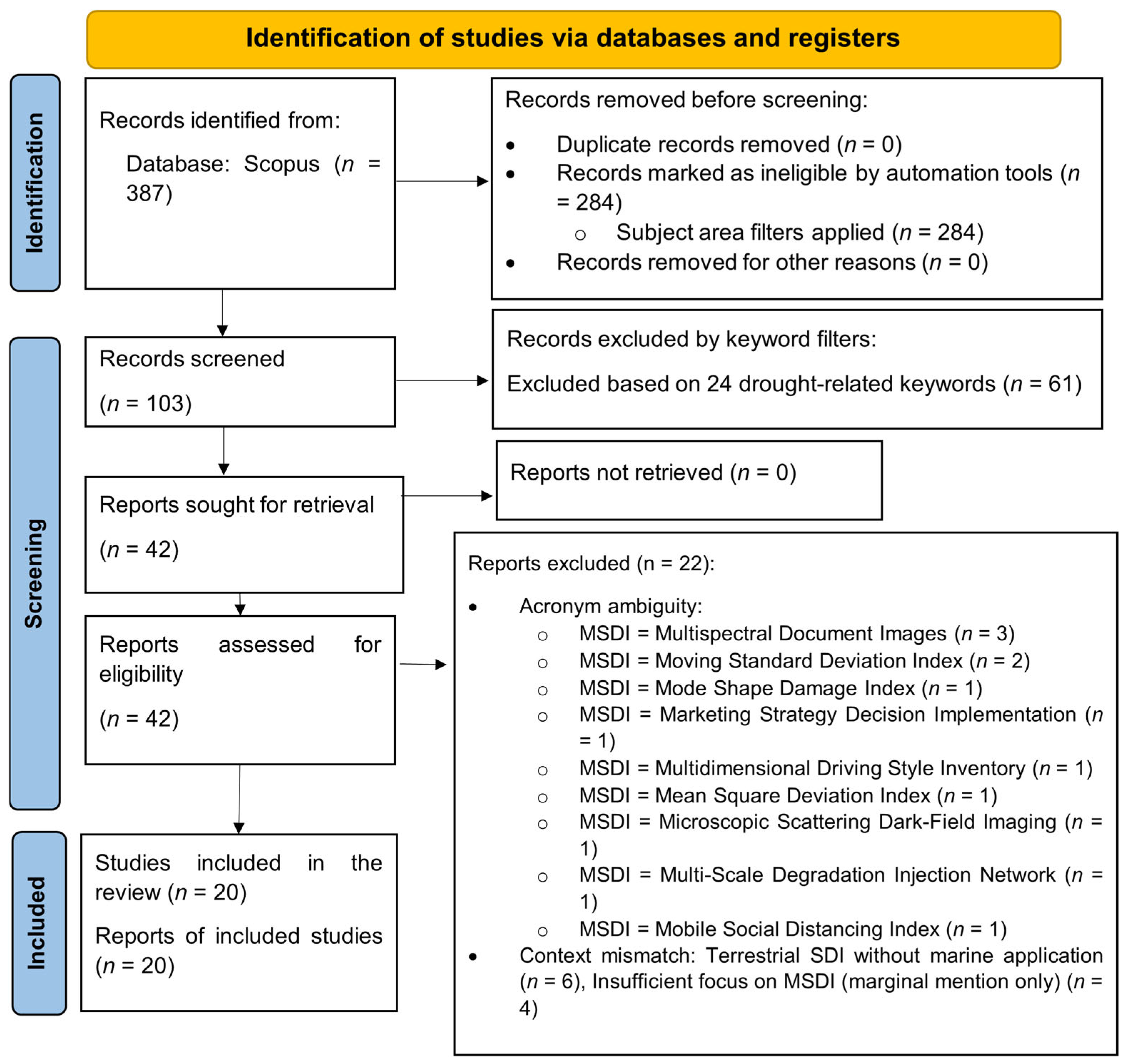
2.4. Screening Process and Study Selection
- Not focused on MSDI as the primary theme (n = 9)
- Review papers presenting no new empirical or conceptual content (n = 5)
- Methodological papers focused solely on data processing algorithms without infrastructure or governance context (n = 4)
- Insufficient focus on MSDI to contribute meaningfully to the field’s intellectual development (n = 4)
2.5. Data Extraction and Management
- Bibliometric Data: Full bibliographic data was exported from Scopus into a CSV file that consists of authors, affiliations, title, abstract, keywords, publication year, journal, and citation counts.
- Qualitative Data: The production of thematic data prevailing in each study, given in four dimensions, based on the research questions, was done using a structured framework:
- ▪
- RQ1 Analysis: publication year, author profiles, and collaboration patterns.
- ▪
- Analysis of RQ2: important areas of intellectual focus.
- ▪
- RQ3 Analysis: developmental phase and research evolution.
- ▪
- Future directions and recommendations: RQ4 Analysis.
2.6. Quality Assessment
- Research objectives are clear (0: Unclear, 1: Partially clear, and 2: Fully clear).
- The methodological appropriateness (0: Inappropriate, 1: Partially appropriate, and 2: Fully appropriate).
- Data/transparency quality (0: Poor/not reported, 1: Moderate, and 2: High/fully transparent).
- Transparency (analytical) (0: Opaque, 1: Partly transparent, and 2: fully transparent).
- Evidence supports the validity of findings (0: Not supported, 1: Partially supported, and 2: Strongly supported by evidence).
- Applicability to MSDI study (0: Peripheral, 1: Relevant, and 2: Central).
- High quality: 11 studies (55%)
- Moderate quality: 7 studies (35%)
- Low quality: 2 studies (10%)
2.7. Data Synthesis and Analysis Methods
2.7.1. Bibliometric Analysis
- Co-word Analysis: a co-occurrence network of author keywords was developed to identify thematic clusters.
- Citation Analysis: to identify the most productive documents and influential works in the field.
- Co-authorship Analysis: to visualise collaboration networks among researchers and countries.
2.7.2. Thematic Synthesis
2.7.3. Temporal Phase Analysis
- Simple (1980s–early 2000s) Techniques Feasibility and Standards development (e.g., [20]).
- Semantic Enhancement (late 2000s–2010s): Interoperability and advanced discovery (e.g., [23])
- Policy Integration (early 2010s): Co-ordination between nations (e.g., [24]) and regulatory co-ordination.
- Advanced Implementation (2010s–2020s): Automation, FAIR principles, and user-centred design (e.g., [25])
2.7.4. Research Focus Analysis
- Technical Implementation: 8 studies (40%).
- Governance and Policy: 6 studies (30%)
- Stakeholder and User Engagement: 4 (20%) studies.
- Evaluation/Assessment: 2 (10%) studies.
2.7.5. Geographic and Institutional Analysis
- European dominance: 15 studies (75%): good representation of Italy, Germany, and Spain.
- Multi-national cooperation: 9 articles (45%), in which cross-border cooperation took place.
- Institutional hubs: Consiglio Nazionale delle Ricerche (Italy), European Environment Agency, and academic consortia.
2.7.6. Future Directions Synthesis
2.8. Integration Strategy
- Triangulation: comparing the clusters of keywords with manually coded themes
- Temporal alignment: tracing publication trends and evolutionary phases
- Network-correlation analysis: connecting patterns of collaboration with areas of thematic focus
3. Results
3.1. RQ1: Publication Trends, Contributors, and Collaboration Networks
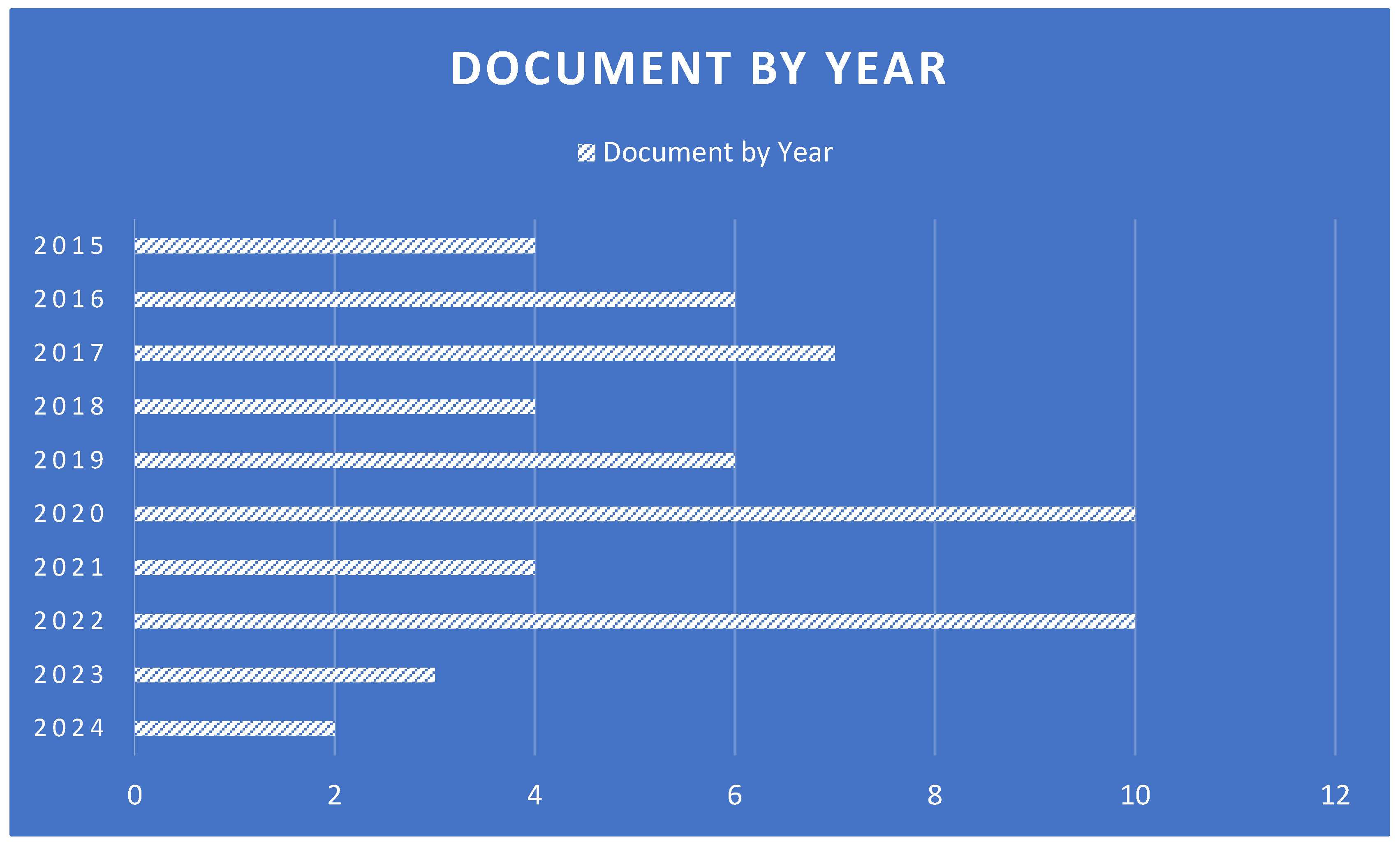
3.1.1. Annual Publication Patterns
- Early development (2002–2009): minor activity, with an average of 0.5 publications/year, which is the conceptualisation stage of MSDI.
- Accelerated growth (2010–2015): the publication rate increased to 1.8/year, which is the same period when significant EU policy motives like the INSPIRE Directive and the Marine Strategy Framework Directive (MSFD) were introduced.
- Consolidation (2016–2020): constant production with an average of 2.2 publications/year; the technical models of production and governance are becoming stable.
- Recent expansion (2021–2024): increase to 3.0 publications/year, and thus a resurgence of interest due to challenges in marine data integration as well as implementation of FAIR principles.
3.1.2. Geographic Distribution of Research
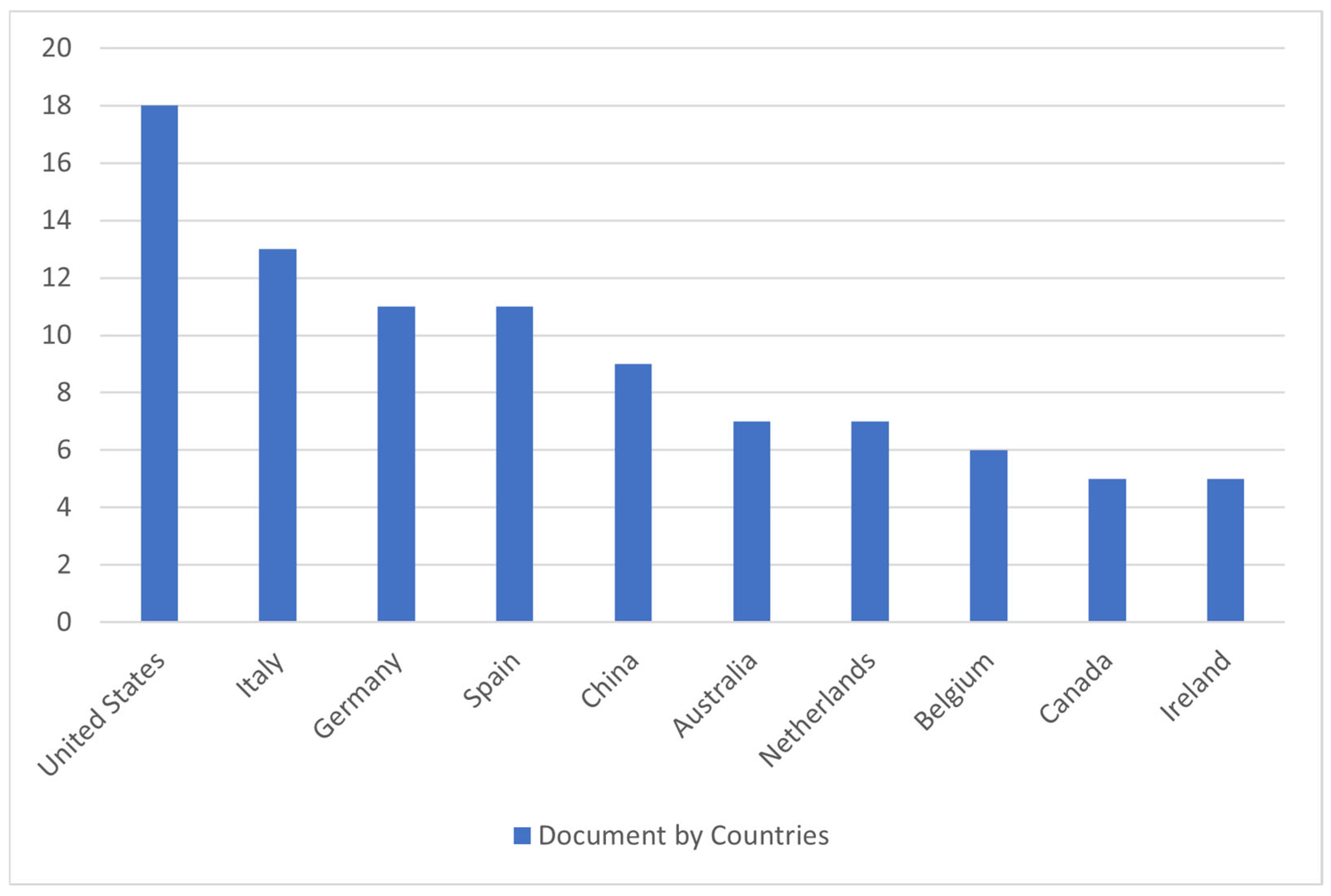
- The concentration of publications from European institutions (75% of the corpus) likely reflects multiple factors: the catalytic role of EU policy frameworks such as INSPIRE and the MSFD; the indexing coverage of Scopus, which may overrepresent English-language European publications; and the specific search terminology employed, which privileged the literature explicitly using the ‘MSDI’ acronym common in European discourse. Research from regions where marine data coordination proceeds under different terminology (e.g., ‘coastal spatial data infrastructure’ and ‘ocean data management systems’) or is published in non-English outlets may be underrepresented. This limitation should be considered when interpreting the geographic patterns.
- Poor International Representation: 25 per cent of the studies are outside Europe, with sporadic participation from Malaysia, Australia, Turkey, and the US.
- Policy-Driven Clusters: INSPIRE and timelines of MSFD implementation. Concentration in EU member states can be viewed as a key source of scholarly output, and it is highly likely that regional policy is the driving force.
3.1.3. Leading Authors and Productivity
- Author Concentration: There is a fairly concentrated research community, as the major contributors to the publications of MSDI represent a substantial percentage of the total publications.
- Institutional Leadership: The CNR researchers in Italy are prominent.
- Interdisciplinary Engagement: A number of well-known authors have a long history of publications in other areas of geospatial or marine science, indicating that MSDI is a sub-specialisation within interdisciplinary fields of employment.
3.1.4. Journal Distribution and Dissemination Patterns
- Medium level of Citation Impact: the average number of citations per document and corpus h-index indicates an immature but not yet well-established field in terms of its scholarly impact.
- Concentrated Recognition: Few papers, especially those that report large-scale technical implementations (e.g., RITMARE project), are disproportionately cited.
- Recent Acceleration: most of the references are post-2015, which indicates the increased awareness of modern work.
3.1.5. Citation Patterns and Influence
3.2. RQ2: Intellectual Structure and Thematic Clusters
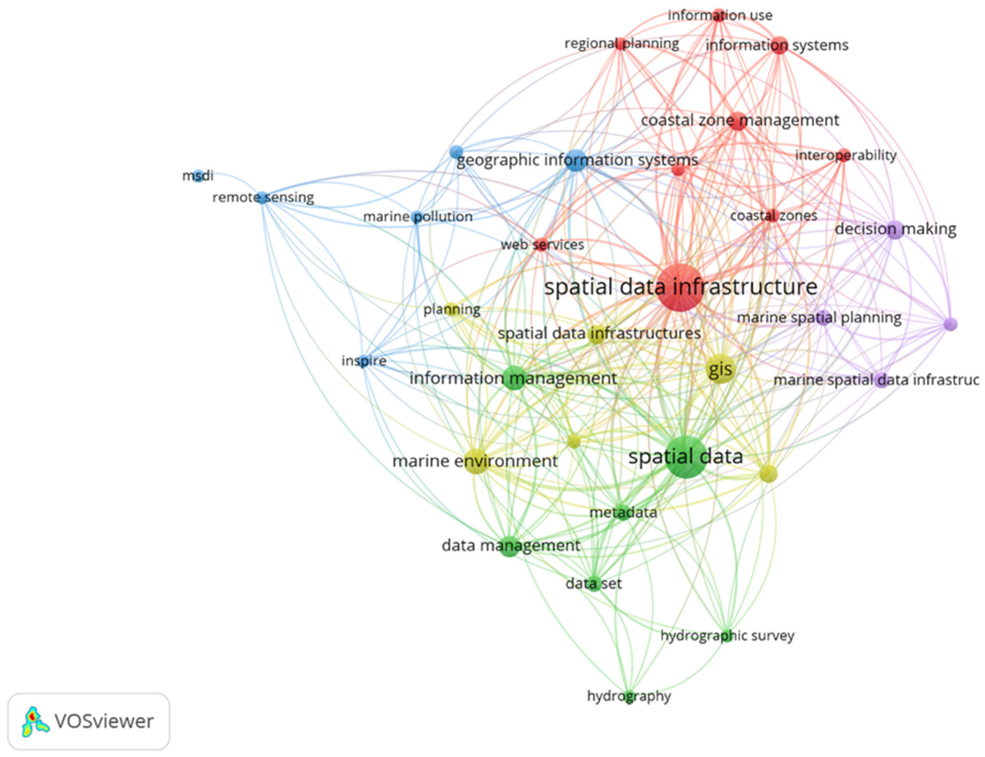
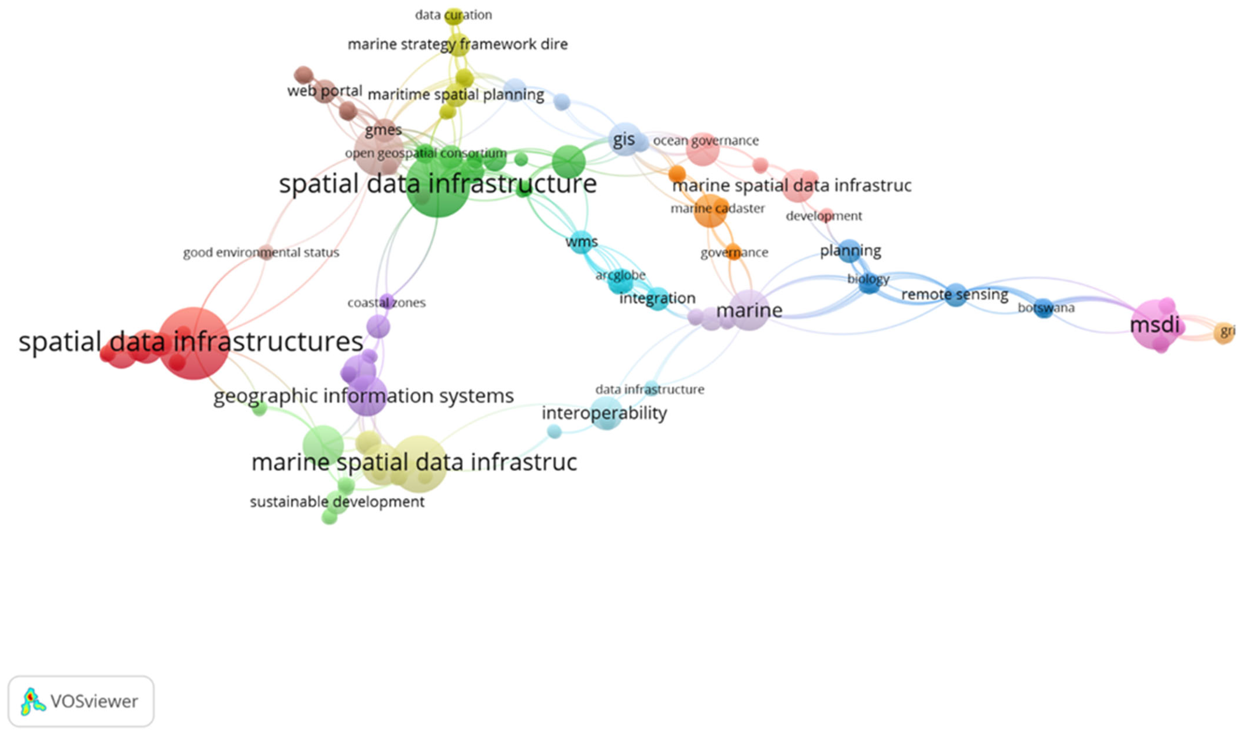
3.2.1. Keyword Co-Occurrence Network
- Cluster 1 (Technical Core): Keywords: spatial data infrastructure, GIS, web map service, and remote sensing. This cluster defines the technical base of MSDI, that is, on the geospatial technologies and data visualisation platforms.
- Cluster 2 (Governance and Policy): Keywords: marine strategy framework directive, governance, planning, and sustainable development. The policy and regulatory dimension is encapsulated within this cluster, and it focuses on conformity with the European directives and environmental targets.
- Cluster 3 (Data Management): Major keywords: data curation, data infrastructure, marine. This cluster is concerned with the data lifecycle, curation practice, and marine-specific infrastructure issues.
- Cluster 4 (Application and Planning): Keywords: “maritime spatial planning,” “development.” This cluster is an application of dimensions, which connects MSDI with real planning processes and results.
3.2.2. Research Focus Distribution
- ▪
- Technical Implementation: 8 (40) studies.
- ▪
- Governance and Policy: 6 studies (30%)
- ▪
- Stakeholder/User Engagement: 4 (20) studies.
- ▪
- Evaluation Assessment: 2 studies (10%).
3.3. RQ3: Temporal Evolution of Research Foci
3.3.1. Phase-Based Evolution
- Foundational (1980s–2006): focus on technical feasibility and simple data standards (e.g., electronic nautical charts).
- Implementation (2007–2010): models of governance and preliminary design of the operational system.
- Semantic Enhancement (2011–2015): the future of semantic interoperability and smart data discovery.
- Policy Integration (2016–2020): well-balanced compliance with regulatory frameworks (e.g., INSPIRE and MSFD) and transnational coordination.
- Advanced Implementation (2021–2024): the introduction of new paradigms, i.e., FAIR/CARE guidelines, automation, and user-friendly design.
3.3.2. Temporal Keyword Evolution
- 2000s: “Electronic charts” and “standards” (technical foundations).
- 2010s: “Semantic interoperability” and “INSPIRE” (technical–policy integration)
- 2020s: AI (modern data science and ethics), user-centred design, and FAIR principles.
3.4. RQ4 Foundation: Synthesis for Future Research Agenda
3.4.1. Convergence of Research Priorities
- Technical Domain: semantic interoperability, AI/ML, and cloud-native.
- Domain of Governance: excellent multi-level governance, policy-practice congruency, as well as transnational alignment. Application Domain: integration of decision support systems, user-centred design, and stakeholder engagement protocols.
- Cross-cutting Themes: implementation of the principles of FAIR and CARE, capacity building, and structure development of the impact assessment.
3.4.2. Quality Assessment Integration
- High-quality research gives one a sound basis of knowledge on the fundamental technical and governance aspects of MSDI.
- Moderate-quality studies provide useful information but have weaknesses in generalisability or detail of analysis.
- Poor-quality studies were interpreted as pilot studies.
4. Discussion
4.1. Synthesis of Key Findings
4.2. Thematic Integration and Knowledge Gaps
4.3. Evolution from Tool to Governance Infrastructure
4.4. Practical Implications
- Gap in standards–practice: Although a wide range of technical standards (OGC, ISO, and IHO) exist, the application of standards is still inconsistent and situational [10].
- Designer–user gap: While the concept of user-centred design keeps gaining momentum, in most cases, systems are designed around the supply-side, instead of the demand-side [29].
4.5. Limitations and Research Frontiers
- ○
- Semantic AI that would generate automated metadata and alignment of ontologies [10].
- ○
- From one point of view, there are distributed, decentralised governance models [33].
- ○
- Elucidable interfaces of clear-cut data relationships [34].
- ○
- Domain 2: Governing Infrastructure Inclusion through Innovation.
- ○
- Multi-jurisdictional models of polycentric governance [13]. These include: equity-based design approaches that address power differentials.
- ○
- The various comparative policy implementations in the various regulatory traditions [24].
- ○
- In ecosystem development of sustainable capacity that goes beyond individual training [28].
- ○
- Measures of unified environmental, social, and economic impacts [17]. Investment payback research on various implementation settings.
- ○
- Longitudinal adoption research of organisational change. Systematic failure analysis is necessary in order to identify avoidable implementation pitfalls.
5. Conclusions
Author Contributions
Funding
Institutional Review Board Statement
Informed Consent Statement
Data Availability Statement
Conflicts of Interest
Abbreviations
| MSDI | Marine Spatial Data Infrastructure |
| SDI | Spatial Data Infrastructure |
| FAIR | Findable, Accessible, Interoperable, Reusable |
| CARE | Collective Benefit, Authority to Control, Responsibility, Ethics |
| INSPIRE | Infrastructure for Spatial Information in the European Community |
| MSFD | Marine Strategy Framework Directive |
| GIS | Geographic Information System |
| AI | Artificial Intelligence |
Appendix A
Appendix A.1. Data Extraction Framework and PRISMA Checklist
Appendix A.1.1. Data Extraction Template

| Extraction Category | Specific Data Points | Linked Research Question |
|---|---|---|
| Bibliographic Info | Authors, Title, Year, Journal, DOI | RQ1 |
| Contributor & Collaboration | Author Affiliations, Countries, Number of Authors, and Mention of Cross-Institutional/International Collaboration | RQ1 |
| Study Focus & Themes | Primary Research Objective; Keywords; Explicitly stated themes (e.g., governance, interoperability, user engagement) | RQ2 |
| Methodology | Type of Study (e.g., case study, framework proposal, evaluation); Data Sources; Analytical Methods | - |
| Key Findings | Summary of main results and conclusions related to MSDI implementation, challenges, or impacts | RQ2, RQ3 |
| Evolutionary Phase | Assigned phase (1–5) based on publication year, thematic focus, and technological/policy context as defined in Section 2.7.3 | RQ3 |
| Future Directions | Explicit recommendations or identified research gaps mentioned by the study’s authors | RQ4 |
| Quality Indicators | Notes on clarity, methodological rigour, and relevance to inform the formal quality assessment (Section 2.6). | - |
Appendix A.1.2. PRISMA 2020 Checklist
| Section/Topic | Item # | PRISMA 2020 Checklist Item | Location in Manuscript Where Item Is Reported |
|---|---|---|---|
| TITLE | 1 | Identify the report as a systematic review. | Title: “…A Systematic Review and Bibliometric Analysis” |
| ABSTRACT | 2 | Provide a structured abstract. | Abstract section (Background, Objective, Methods, Results, Conclusions) |
| INTRODUCTION | 3 | Describe the rationale for the review in the context of existing knowledge. | Introduction, paragraphs 1–4 |
| 4 | Provide an explicit statement of the objective(s) or question(s) the review addresses. | Introduction, final paragraph (numbered list) | |
| METHODS | 5 | Specify the inclusion and exclusion criteria for the review. | Section 3.3 & Table 1 |
| 6 | Specify the information sources (e.g., databases, registers) used to identify studies and the date of last search. | Section 3.2 | |
| 7 | Present the full search strategy for at least one database. | Section 3.2.2 (Search Query) | |
| 8 | Specify the methods used to select studies (e.g., number of reviewers, screening process). | Section 3.4 | |
| 9 | Specify the methods used to extract data from reports (e.g., number of reviewers, extraction form). | Section 2.5 & Appendix A (Table A1) | |
| 10 | List and define all outcomes for which data were sought. | Section 2.5 & Section 2.7 (Analysis corresponds to RQs) | |
| 11 | Specify the methods used to assess the risk of bias (methodological quality) in the included studies. | Section 2.6 | |
| 12 | Specify the methods used to synthesise results (e.g., bibliometric mapping, thematic synthesis). | Section 2.7 | |
| RESULTS | 13 | Describe the results of the search and selection process, using a flow diagram. | Section 2.4 & Figure 1 (PRISMA Flow Diagram) |
| 14 | Cite each included study. | Throughout Results & Reference List | |
| 15 | Present results for each synthesis (e.g., bibliometric networks, thematic clusters, evolutionary phases). | Section 3 (Results) | |
| DISCUSSION | 16 | Provide a general interpretation of the results in the context of other evidence. | Section 4.1, Section 4.2 and Section 4.3 |
| 17 | Discuss any limitations of the evidence included in the review. | Section 4.5 (first paragraph) | |
| 18 | Discuss any limitations of the review processes used. | Section 4.5 (first paragraph) | |
| 19 | Provide a general interpretation of the results and implications for future research/practice. | Section 4.4 and Section 4.5 | |
| OTHER | 20 | Describe sources of financial or non-financial support. | (To be completed by author) |
| 21 | Register and registration number for the review, if registered. | (If applicable) |
Appendix B. Individual Study Analysis Summary
| Label | Authors (Year) | RQ1: Publication Trends & Collaboration | RQ2: Intellectual Structure & Thematic Clusters | RQ3: Temporal Evolution of Research Foci | RQ4: Directions & Recommendations |
|---|---|---|---|---|---|
| 1 | Hecht, H. (2002) | Era & Contributor: Early (2002) foundational work from a key German hydrographic agency (BSH). Highlights early collaboration between Hydrographic Offices and Maritime Administrations. | Core Theme: Technical Foundation & Initial Application. Focuses on the transition from paper to electronic charts (ECDIS/ENCs) and the S-57 standard. Introduces the concept of marine data as a multi-purpose GIS for safety, pollution, and coastal management. | Phase: Foundational/Early Development (1980s–early 2000s). Focus is on establishing the technical feasibility and initial use cases for digital marine data, moving from navigation to broader administrative applications. | 1. Governance & Coordination: Maritime Administrations must take an active, coordinating role to avoid data silos and ensure integrity. 2. High-Accuracy Data: Advocates for developing marine geodatabases from high-accuracy “geo-basedata,” not just digitised charts. 3. Holistic Integration: Marine space must be managed as a unity, with data from many sources growing together into a comprehensive infrastructure. |
| 2 | Finney, K. T. (2007) | Era & Contributor: Mid-period (2007) research from an Australian scientist. Exemplifies a “bottom-up,” community-driven collaboration model (AODC JF consortium) for SDI development, in contrast to top-down government approaches. | Core Theme: Governance & Implementation Models. The central theme is the governance challenges and frameworks for Service-Oriented Architecture (SOA)-based SDIs. Introduces a detailed framework with actors for managing standards, services, and volunteer communities in open development. | Phase: Implementation & Governance (mid-2000s). Research focus evolves from what an MSDI is to how to build and govern one effectively, especially using new SOA/web service paradigms. | 1. Adopt Open Models: Proposes harnessing open-source development models and volunteer communities to accelerate growth and defray costs. 2. Formalise Governance: Stresses the need for a clear governance framework with defined roles to manage standards, service quality, and community participation. 3. User-Centric Design: SDIs must transition from supply-side to service/market-driven approaches to increase public penetration. |
| 3 | Stock, K. M. et al. (2010) | Era & Contributor: Late-period (2010) collaborative work by an international academic/industry group. Shows advanced, cross-border technical collaboration focusing on semantic interoperability. | Core Theme: Semantic Interoperability & Advanced Discovery. Focuses on enhancing SDI registries with rich semantics using a Feature Type Catalogue (FTC). Proposes an alternative to ontology-based approaches by encapsulating a feature type’s attributes, operations, and associations. | Phase: Maturation & Semantic Enhancement (late 2000s–2010s). Research advances into solving semantic interoperability challenges for advanced discovery, service chaining, and automated use. | 1. Semantic Separation: Advocates for separating the conceptual semantics (in the FTC) from the implementation details (web service bindings). 2. Formalise FTC Model: Recommends further formalisation of the FTC approach, potentially into a new ontology. 3. Encapsulation for Navigation: The encapsulated FTC model aids in navigation, inheritance, and managing semantics across domains. |
| 4 | Rith, C., & Bill, R. (2012) | Era & Contributor: Later-period (2012) research from German academia (Rostock University). Demonstrates a multi-agency, top-down collaborative project (MDI-DE) involving federal institutes and regional authorities, guided by European directives. | Core Theme: Practical Implementation, Regulatory Alignment & Evaluation. Focuses on building a reference model (based on ISO RM-ODP) for a national MSDI, modelling regulatory workflows (e.g., MSFD), and developing a framework to evaluate and compare international MSDIs. | Phase: Consolidation & Regulatory Integration (early 2010s). Research focus shifts to practical, policy-driven implementation within a strict regulatory framework (INSPIRE, MSFD). | 1. Standardised Modelling: Advocates for using structured reference and process models (UML) to manage complex, multi-partner MSDI developments. 2. Regulatory-Driven Design: MSDI development must be explicitly aligned with and driven by regional and international directives. 3. Systematic Evaluation: Proposes the adoption of a structured evaluation framework with defined technical and organisational indicators. |
| 5 | Ó Tuama, É., & Hamre, T. (2007) | Era & Contributor: Mid-period (2007) work from Irish and Norwegian research centres, showcasing cross-border, multi-institutional collaboration under an EU-funded project (DISMAR). Reflects early operational SDI implementation in Europe. | Core Theme: Operational SDI Implementation & Interoperability. Focuses on building a web-based distributed GIS using OGC standards (WMS), ISO metadata (19115), and open-source tools. Centres on data harmonisation, metadata profiling, and service integration for marine pollution monitoring. | Phase: Operational Piloting & Service Integration (mid-2000s). Represents the shift from theoretical SDI frameworks to practical, multi-source, distributed systems for environmental crisis management. | 1. Adopt Open Standards & Architectures: Advocates for REST-based architectures, OGC WMS, and ISO metadata to ensure interoperability and scalability. 2. Enhance Metadata Quality & Semantics: Stresses the need for accurate, validated metadata and semantic enrichment. 3. Transition to Operational Services: Argues that prototype systems should evolve into sustained GMES operational services. |
| 6 | Wheeler, P., & Peterson, J. (2010) | Era & Contributor: Late-period (2010) qualitative case study from Australian academia. Represents regional, stakeholder-centred research focusing on sociotechnical adoption barriers rather than technical development. | Core Theme: Stakeholder Analysis & Sociotechnical Barriers. Investigates the human and institutional constraints to the adoption of spatial information and GIS for ICZM. Key themes include a lack of policy alignment, insufficient capacity building, organisational silos, and data-sharing challenges. | Phase: Implementation Challenges & User-Centric Perspectives (late 2000s–early 2010s). Research shifts from technical SDI/ICZM design to understanding real-world adoption barriers, stakeholder needs, and the policy-practice gap. | 1. Bottom-Up Stakeholder Engagement: Future SDI/ICZM initiatives must be informed by user needs and regional realities. 2. Capacity Building & Training: Calls for dedicated ICZM and GIS training programmes. 3. Policy-Practice Convergence: Advocates for better alignment between ICZM policy and spatial information infrastructure development. |
| 7 | Tarmidi, Z. M. et al. (2016) | Era & Contributor: Recent period (2016) research from Malaysian academia. Examines multi-organisational, national-level challenges in marine SDI implementation. Highlights fragmented cooperation across marine-related agencies. | Core Theme: Organisational Readiness & Cooperation Frameworks. Focuses on internal and inter-agency barriers to marine spatial data sharing, including technological gaps, data quality issues, institutional silos, and a lack of strategic GIS planning. | Phase: Operational & Strategic Capacity Building (mid-2010s). Research reflects the maturation phase of SDI implementation, emphasising organisational empowerment, strategic planning, and inter-agency collaboration. | 1. Strategic GIS Planning: Organisations need clear, long-term GIS strategies. 2. Enhance Inter-Agency Cooperation: Formal and informal networks and clear communication channels are essential. 3. Empower GIS Personnel: Invest in training, hiring, and retention of skilled GIS staff. |
| 8 | Rajabifard, A. et al. (2006) | Era & Contributor: Mid-period (2006) seminal work by an international SDI research group. Provides a global, comparative analysis of SDI evolution, highlighting shifts from national to sub-national leadership. | Core Theme: SDI Governance & Evolutionary Models. Introduces the first vs. second-generation SDI framework (product-based vs. process-based) and analyses the changing roles of national governments, sub-national authorities, and the private sector in SDI development. | Phase: Transition to Decentralised & User-Driven SDIs (mid-2000s). Captures the shift from national, small-scale SDIs to sub-national and private-sector-driven, large-scale, application-focused infrastructures. | 1. Embrace Multi-Level Governance: Effective SDIs require coordination across national, sub-national, and private sectors. 2. Shift to Process-Based Models: Move from product-centric to user-centric, service-oriented SDI frameworks. 3. Empower Sub-National Actors: State/local governments and the private sector should lead operational SDI development. |
| 9 | Resch, B. et al. (2014) | Era & Contributor: Recent period (2014) technical research from a German-Austrian-American academic consortium. Represents cutting-edge, interdisciplinary collaboration focusing on advanced visualisation technologies. | Core Theme: Advanced Visualisation & User Experience. Centres on 4D (3D + time) web-based visualisation of marine data using WebGL. Key themes include usability design, cognitive aspects of spatiotemporal perception, and user-centric interface development for both expert and non-expert audiences. | Phase: Advanced Technical Implementation & User-Centric Design (2010s). Reflects the maturation of SDI/WebGIS into sophisticated, interactive, and accessible visualisation platforms. | 1. Adopt Modern Web Technologies: Advocates for WebGL as a high-performance, plug-in-free standard. 2. Prioritise Usability & User-Centred Design: Stresses the need for intuitive interfaces and adherence to usability principles. 3. Develop 4D Cartographic Principles: Calls for research into graphical variables for 4D. |
| 10 | Dabrowski, J. et al. (2009) | Era & Contributor: Late 2000s (2009), from Gdańsk University of Technology, Poland. Represents academic-led technical development with a focus on real-time system integration. | Core Theme: Real-Time Technical Integration & Advanced Visualisation. Focuses on building a hybrid GIS system to integrate multi-sensor marine data (sonar, radar, satellite, AIS) and enable interactive 2D/3D visualisation. | Phase: Advanced Technical Implementation & Real-Time Integration (late 2000s). Research focus shifts toward operational, real-time marine monitoring systems, emphasising sensor data streaming and web-based accessibility. | 1. Adopt Modular & Hybrid Architectures: Combine web-based and standalone systems to serve diverse user needs. 2. Enhance Real-Time Data Pipelines: Develop dedicated servers for streaming data with low latency. 3. Advance 3D/4D Visualisation: Use tools like ArcGIS Engine and WebGL for realistic data rendering. |
| 11 | Meiner, A. (2013) | Era & Contributor: Early 2010s (2013), from the European Environment Agency. Represents a high-level, policy-driven perspective focused on EU-wide marine data integration. | Core Theme: Policy-Driven SDI Development & Integrated Ecosystem Assessment. Focuses on the need for a coherent spatial data infrastructure to support ecosystem-based management. Central themes include data sharing (SEIS, EMODnet), integration of socio-economic data, and interoperability (INSPIRE, OGC). | Phase: Consolidation & Policy Implementation (early 2010s). Research focus shifts toward operationalising EU directives (MSFD, INSPIRE) and establishing practical data management priorities for regional assessments. | 1. Prioritise Data Sharing & Standardisation: Implement SEIS principles and leverage EMODnet for harmonised data. 2. Integrate Socio-Economic Data: Systematically link environmental data with geo-referenced socio-economic statistics. 3. Strengthen Transnational Coordination: Foster coordinated action across EU marine regions. |
| 12 | Navas, F. et al. (2016) | Era & Contributor: Mid-2010s (2016), from a Spanish academic consortium. Represents applied, project-based collaboration under EU-funded initiatives, focusing on technical SDI implementation. | Core Theme: Technical Interoperability & SDI Implementation for Forecasting. Focuses on building dedicated SDI platforms using open-source, OGC-compliant technologies to support forecasting through interoperable data services and integration of model outputs. | Phase: Operational & Advanced Technical Implementation (mid-2010s). Research reflects the maturation of SDIs into practical, user-centric tools for environmental management and forecasting. | 1. Adopt Open Standards & Architectures: Use OGC services and open-source stacks to ensure interoperability. 2. Enhance Metadata Quality & Semantics: Implement ISO metadata standards and link with GEOSS. 3. Bridge the Land–Sea Data Divide: Overcome technical barriers to integrate terrestrial and marine data. |
| 13 | French, M. A., & Lipizer, M. (2023) | Era & Contributor: Recent period (2023), from an Italian oceanographic institute within the EMODnet Chemistry network. Represents large-scale, international technical collaboration focusing on data quality and harmonisation for regulatory compliance. | Core Theme: Data Reliability, FAIR Principles & Quality Assurance. Centres on improving the comparability and reusability of marine contaminant data through standardised QA/QC metadata collection, harmonisation of analytical methods, and enhanced data curation practices. | Phase: Maturation & Data Quality Enhancement (2020s). Research focus shifts toward ensuring data fitness for assessment under MSFD, implementing FAIR principles, and establishing systematic data curation workflows. | 1. Harmonise QA/QC Metadata Collection: Develop and enforce standardised questionnaires. 2. Promote Adoption of FAIR Principles: Ensure data are Findable, Accessible, Interoperable, and Reusable. 3. Strengthen Data Curation Processes: Recognise and fund data curation as a critical component. |
| 14 | Wulff, E. (2020) | Era & Contributor: Recent period (2020), from a Spanish research council. Represents a library and information science perspective on marine SDI, focusing on the national-level assessment of OGC standard implementation. | Core Theme: Technical Implementation & Assessment of OGC Standards in National SDI. Focuses on evaluating the adoption of OGC web services (WMS, WFS, CSW) in Spanish oceanographic data repositories, compliance with INSPIRE, and the role of libraries/repositories. | Phase: Technical Implementation & Compliance Assessment (late 2010s–2020). Research reflects a maturity phase of SDI development, shifting focus to evaluating real-world implementation and repository-level readiness. | 1. Strengthen OGC Service Implementation: Increase the number and quality of INSPIRE-compliant OGC web services. 2. Improve Metadata Compliance: Ensure metadata adheres to INSPIRE and ISO standards. 3. Enhance Marine Data Literacy: Develop training programmes for librarians and data managers. |
| 15 | Tarmidi, Z. et al. (2016). [Duplicate of #7 for thematic emphasis] | Era & Contributor: Mid-2010s (2016) research from Malaysian academia. It represents a national-level, survey-based exploratory study focusing on marine and coastal organisations in Malaysia. | Core Theme: Organisational Readiness, GIS Implementation & Intra/Inter-Agency Collaboration. Focuses on critical factors for spatial data sharing, including GIS planning, data sharing knowledge, and collaboration mechanisms. | Phase: Operational & Strategic Capacity Building (mid-2010s). Research reflects the maturation phase of SDI implementation, emphasising organisational empowerment and strategic GIS planning. | 1. Develop Strategic GIS Plans: Organisations should adopt long-term GIS strategies. 2. Foster Inter-Agency Cooperation: Establish formal and informal networks and clear communication channels. 3. Empower GIS Personnel: Invest in training, retention, and dedicated GIS units. |
| 16 | Tavra, M. et al. (2017) | Era & Contributor: Mid-2010s (2017) research from Croatian academia. Represents a national case study focused on methodological development and stakeholder-driven prioritisation for MSDI planning. | Core Theme: MSDI Planning, Prioritisation & Decision Support Systems. Proposes a Planning Support Concept (PSC) integrating multi-criteria decision-making (MCDM) methods to prioritise marine data themes. Emphasises stakeholder engagement, goal structuring, and phased implementation. | Phase: Operational Planning & Prioritisation (mid-2010s). Represents the maturation of MSDI implementation research, shifting from conceptual frameworks to practical, stakeholder-informed planning tools. | 1. Adopt Structured Planning Frameworks: Implement multi-criteria decision-support systems (e.g., AHP, PROMETHEE). 2. Engage Stakeholders Early: Involve diverse stakeholder groups in goal-setting and data-needs assessment. 3. Phased Implementation: Develop MSDI in iterative phases, starting with high-priority themes. |
| 17 | Racetin, I. et al. (2022) | Era & Contributor: Recent period (2022) bibliometric study from Croatian academia. Represents a global, analytical review of MSDI and Marine Cadastre (MC) literature using bibliometric methods. | Core Theme: Bibliometric Assessment, Research Trends & Knowledge Gaps in MSDI/MC. Focuses on quantifying scientific output, identifying thematic clusters, and evaluating the recognition of MSDI and MC within marine spatial planning (MSP) and Blue Economy (BE) literature. | Phase: Reflective & Evaluative Research (2020s). Represents a meta-analysis phase in MSDI research, shifting from technical/implementation studies to a systematic assessment of the field’s evolution and gaps. | 1. Strengthen Technical & Scientific Engagement: Increase research output from engineering and technical disciplines. 2. Enhance Global Collaboration: Foster international and interregional research partnerships. 3. Bridge MSDI-MSP-BE Research: Encourage interdisciplinary studies linking technical frameworks with planning and sustainability goals. |
| 18 | Contarinis, S. et al. (2022) | Era & Contributor: Recent period (2022) technical research from Greek academia. Represents applied, open-source technical development with a strong focus on automation and interoperability. | Core Theme: Technical Implementation & Automation of Nautical Chart Compilation. Focuses on automated compilation of web-based nautical charts using open hydrospatial data and open-source software. Key themes include IHO S-101 standards, data generalisation, and vector-tile visualisation. | Phase: Advanced Technical Implementation & Interoperability (2020s). Reflects the maturation of MSDI and open-data initiatives, shifting focus to operational automation, standards-compliant products, and web-based service delivery. | 1. Leverage Open Standards & Open Data: Promote use of IHO S-101 and openly available hydrospatial data. 2. Automate Compilation Workflows: Develop robust, repeatable automated processes using open-source libraries. 3. Adopt Modern Web Cartography Techniques: Utilise vector-tile technologies for efficient, interactive chart visualisation. |
| 19 | Contarinis, S. et al. (2020) | Era & Contributor: Recent period (2020) research from Greek academia. Represents European academic and technical collaboration aligned with IHO, W3C, OGC, and EU directives. | Core Theme: Technical Interoperability, Open Data Infrastructures & Universal Data Modelling. Focuses on the IHO S-100 standard as a universal marine data model, comparing it with S-57 and INSPIRE. Key themes include marine spatial data infrastructures (MSDI), open data platforms, and digital government transformation. | Phase: Advanced Technical Integration & Policy Alignment (late 2010s–2020). Research reflects the convergence of technical standards, open data policies, and web-based data infrastructures. | 1. Adopt IHO S-100 as Universal Marine Data Model: Advocates for S-100 due to its ISO alignment and extensibility. 2. Leverage Open Data Platforms & Web Standards: Recommends platforms like CKAN/GeoNode and W3C/OGC best practices. 3. Strengthen Governance & Stakeholder Engagement: Calls for clear MSDI governance frameworks and multi-stakeholder collaboration. |
| 20 | Lathrop, R. G. et al. (2017) | Era & Contributor: Mid-2010s (2017) collaborative work involving U.S. academia, NGOs, and government agencies. Exemplifies applied, stakeholder-driven collaboration focused on operationalising a regional ocean data portal. | Core Theme: Operational Data Portals, Stakeholder Engagement & Decision Support. Centres on the development, application, and evaluation of the Mid-Atlantic Ocean Data Portal as a Public Participation GIS (PPGIS) tool. Key themes include interactive WebGIS for planning, data accessibility & transparency, and stakeholder-centric design. | Phase: Operational Implementation & User Engagement (mid-2010s). This study reflects the maturation phase of regional MSDI/WebGIS implementation, where research shifts to evaluating its application in real-world planning processes. | 1. Maintain Data Currency & Authority: Implement institutionalised, automated workflows for data updates. 2. Prioritise User-Centred & Iterative Design: Continuously incorporate user feedback through an iterative design process. 3. Foster Cross-Jurisdictional Data Integration: Enhance coordination with national and other regional/state data portals. |
References
- Havice, E.; Campbell, L. Ocean Data Science Initiatives as ocean governance actors. In Proceedings of the One Ocean Science Congress 2025, Nice, France, 3–6 June 2025. [Google Scholar] [CrossRef]
- Kollert, J.; Visbeck, M.; Brönner, U. Digital Twins of the Ocean—Opportunities to Inform Sustainable Ocean Governance. In Proceedings of the EGU General Assembly 2023, Vienna, Austria, 24–28 April 2023. [Google Scholar] [CrossRef]
- Bernard, L.; Kanellopoulos, I.; Annoni, A.; Smits, P. The European geospatial information infrastructure: A critical view. In Proceedings of the 8th AGILE Conference on Geographic Information Science, Estoril, Portugal, 26–28 May 2005; pp. 437–446. [Google Scholar]
- Lee, T.R.; Phrampus, B.J.; Obelcz, J. Optimising the data lifecycle: Marine geosciences in the big data era. Front. Earth Sci. 2023, 10, 1089112. [Google Scholar] [CrossRef]
- Rack, F.; Milne, P.; Fippinger, P.; Jahnke, R. Emerging needs and existing links in distributed ocean science research data sets. In Proceedings of the 2005 IEEE International Symposium on Mass Storage Systems and Technology, Monterey, CA, USA, 11–14 April 2005; pp. 9–13. [Google Scholar] [CrossRef]
- Dunic, N.; Vilibic, I. Advancing Open Science in Oceanography: A Global Assessment of Data Availability and Sharing Practices. In Proceedings of the EGU General Assembly 2024, Vienna, Austria, 14–19 April 2024. [Google Scholar] [CrossRef]
- Van De Putte, A.P.; Griffiths, H.J.; Brooks, C.; Bricher, P.; Sweetlove, M.; Halfter, S.; Raymond, B. From data to Marine Ecosystem Assessments of the Southern Ocean: Achievements, challenges, and lessons for the future. Front. Mar. Sci. 2021, 8, 637063. [Google Scholar] [CrossRef]
- O’Connor, H.M.; Cooper, J.A.G. Coastal and Marine Management—Navigating islands of data. Mar. Policy 2024, 169, 106279. [Google Scholar] [CrossRef]
- Ramírez, F.; Sbragaglia, V.; Soacha, K.; Coll, M.; Piera, J. Challenges for marine ecological assessments: Completeness of findable, accessible, interoperable, and reusable biodiversity data in European seas. Front. Mar. Sci. 2022, 8, 802235. [Google Scholar] [CrossRef]
- Al-Subhi, N.H.; Al-Suqri, M.N. Integrating conceptual modelling and ontologies in marine spatial data infrastructure design. Int. J. Semant. Web Inf. Syst. 2025, 21, 1–18. [Google Scholar] [CrossRef]
- Cinnirella, S.; March, D.; O’Higgins, T.; Murciano, C.; Sardá, R.; Albaigés, J.; Pirrone, N. A multidisciplinary Spatial Data Infrastructure for the Mediterranean to support implementation of the Marine Strategy Framework Directive. Int. J. Spat. Data Infrastruct. Res. 2012, 7, 323–351. [Google Scholar] [CrossRef]
- Glaves, H.M. Developing a common global framework for marine data management. In Advances in Environmental Engineering and Green Technologies Book Series; IGI Global: Hershey, PA, USA, 2016; pp. 47–68. [Google Scholar] [CrossRef]
- Kelly, C.; Ellis, G.; Flannery, W. Unravelling persistent problems to transformative marine governance. Front. Mar. Sci. 2019, 6, 213. [Google Scholar] [CrossRef]
- Foley, M.M. Ocean governance and institutional change: The case of marine spatial data infrastructures. Ocean Yearb. 2009, 23, 421–444. [Google Scholar] [CrossRef]
- Al-Subhi, N.H.A.; Al-Suqri, M.N. Understanding the Role of Artificial Intelligence in Marine Spatial Data Infrastructure: A Crucial Step Towards Smarter Ocean Management. In Proceedings of the International Conference for Artificial Intelligence, Applications, Innovation and Ethics (AI2E), Muscat, Oman, 3–5 February 2025. [Google Scholar] [CrossRef]
- Shankar, R.; Gupta, S.; Nair, T.M.B. Artificial intelligence in ocean data management: A review. J. Ocean. Technol. 2021, 16, 45–62. [Google Scholar]
- Racetin, I.; Pamuković, J.K.; Zrinjski, M. Role of marine spatial data infrastructure and marine cadastre in a sustainable world. J. Mar. Sci. Eng. 2022, 10, 1407. [Google Scholar] [CrossRef]
- Page, M.J.; McKenzie, J.E.; Bossuyt, P.M.; Boutron, I.; Hoffmann, T.C.; Mulrow, C.D.; Shamseer, L.; Tetzlaff, J.M.; Akl, E.A.; Brennan, S.E.; et al. The PRISMA 2020 statement: An updated guideline for reporting systematic reviews. BMJ 2021, 372, n71. [Google Scholar] [CrossRef] [PubMed]
- Mongeon, P.; Paul-Hus, A. The journal coverage of Web of Science and Scopus: A comparative analysis. Scientometrics 2015, 106, 213–228. [Google Scholar] [CrossRef]
- Rajabifard, A.; Feeney, M.F.; Williamson, I.P. Future directions for SDI development. Int. J. Appl. Earth Obs. Geoinf. 2002, 4, 11–22. [Google Scholar] [CrossRef]
- Finney, K.T. A “bottom up” governance framework for developing Australia’s marine Spatial Data Infrastructure (SDI). Data Sci. J. 2015, 6, 64–90. [Google Scholar] [CrossRef][Green Version]
- Tuama, É.Ó.; Hamre, T. Design and implementation of a distributed GIS portal for oil spill and harmful algal bloom monitoring in the marine environment. Mar. Geod. 2006, 30, 145–168. [Google Scholar] [CrossRef]
- Stock, K. From here to eternity: An experiment applying the e-Framework infrastructure for education and research and the SUMO ontology to standards-based geospatial Web services. Int. J. Spat. Data Infrastruct. Res. 2010, 5, 1–57. [Google Scholar] [CrossRef]
- Meiner, A. Spatial data management priorities for assessment of Europe’s coasts and seas. J. Coast. Conserv. 2011, 17, 271–277. [Google Scholar] [CrossRef]
- Contarinis, S.; Kastrisios, C. Marine Spatial Data infrastructure. In Geographic Information Science & Technology Body of Knowledge; University Consortium for Geographic Information Science: Washington, DC, USA, 2022. [Google Scholar] [CrossRef]
- Fugazza, C.; Basoni, A.; Menegon, S.; Oggioni, A.; Pavesi, F.; Pepe, M.; Sarretta, A.; Carrara, P. RITMARE: Semantics-aware harmonisation of data in Italian Marine research. Procedia Comput. Sci. 2014, 33, 261–265. [Google Scholar] [CrossRef]
- Huang, D.; Zhao, D.; Wei, L.; Wang, Z.; Du, Y. Modelling and analysis in Marine Big Data: Advances and challenges. Math. Probl. Eng. 2015, 2015, 384742. [Google Scholar] [CrossRef]
- Tarmidi, Z.; Shariff, A.R.M.; Mahmud, A.R.; Ibrahim, Z.Z.; Hamzah, A.H. Exploratory study on Marine SDI implementation in Malaysia. IOP Conf. Ser. Earth Environ. Sci. 2016, 37, 012014. [Google Scholar] [CrossRef]
- Wheeler, P.; Peterson, J. Exploring Stakeholder Views Regarding Spatial Information and Enabling Technology Use for ICZM: A Case Study from Victoria, Australia. Coast. Manag. 2009, 38, 1–21. [Google Scholar] [CrossRef]
- Cömert, Ç.; Akıncı, H.; Şahin, N.; Bahar, Ö. The value of marine spatial data infrastructure for integrated coastal zone management. Fresenius Environ. Bull. 2008, 17, 2240–2249. Available online: https://www.researchgate.net/publication/228996397_The_value_of_marine_spatial_data_infrastructure_for_integrated_coastal_zone_management (accessed on 24 December 2025).
- Osborne, M.; Pepper, J. The evolution and liberation of hydrographic data. OceanWise 2014, 13, 34–36. Available online: https://www.scopus.com/pages/publications/84899799751 (accessed on 24 December 2025).
- Cheripka, A. Harnessing Open Ocean Data for Global Solutions: Empowering International Collaboration Through FAIR and CARE Principles. In Proceedings of the One Ocean Science Congress 2025, Nice, France, 3–6 June 2025. [Google Scholar] [CrossRef]
- Freestone, D.; Bjergstrom, K.N.; Gjerde, K.M.; Halpin, P.; Fleming, K.P.; Hudson, A.; Rogers, A.D.; Sapsford, F.; Tsontos, V.M.; Vazquez-Cuervo, J.; et al. High seas in the cloud: The role of big data and artificial intelligence in support of high seas governance—The Sargasso Sea pilot. Front. Mar. Sci. 2024, 11, 1427099. [Google Scholar] [CrossRef]
- Resch, B.; Wohlfahrt, R.; Wosniok, C. Web-based 4D visualisation of marine geo-data using WebGL. Cartogr. Geogr. Inf. Sci. 2014, 41, 235–247. [Google Scholar] [CrossRef]
- Debels, P.; Sabir, K.; Uriola, J.; Haughton, M.; Ouadi, Y.D.; Inniss, L.; Debeauville-Scott, S.; Infante, J.; Núñez, A.M.; Dubrie, A.; et al. Integrated Ocean Governance, a regional Coordination Mechanism, and a Marine Data, Information and Knowledge Management Blueprint for the Wider Caribbean. In Proceedings of the One Ocean Science Congress 2025, Nice, France, 3–6 June 2025. [Google Scholar] [CrossRef]
- Von Schuckmann, K. Global Ocean Indicators: Marking pathways at the science-policy nexus. In Proceedings of the One Ocean Science Congress 2025, Nice, France, 3–6 June 2025. [Google Scholar] [CrossRef]
- Tsontos, V.M.; Vázquez-Cuervo, J.; Huang, T.; Chin, T.; Roberts, J.T.; Jacob, J.C.; Platt, F.; Yathirajam, V. Synopsis of a consultative workshop at the Ocean Sciences Meeting 2022 on the CEOS Ocean Variables Enabling Research and Applications for GEO (COVERAGE) initiative. Limnol. Oceanogr. Bull. 2022, 31, 53–55. [Google Scholar] [CrossRef]



| No. | Criterion Type | Specific Criteria | Description/Rationale |
|---|---|---|---|
| 1 | Inclusion Criteria | Content Relevance | Direct attention to the MSDI conceptualisation, application, assessment, or use as a marine/coastal environmental spatial data infrastructure. |
| 2 | Contextual Focus | Understandable marine, coastal, or oceanographic context of the spatial data infrastructure discussion. | |
| 3 | Document Type | Conference papers are listed in an index or in peer-reviewed journal articles. | |
| 4 | Temporal Scope | The date of publication lies between January 2000 and December 2024. | |
| 5 | Language | English-language publications | |
| 6 | Acronym Specificity | MSDI is specifically defined as Marine Spatial Data Infrastructure or Marine Spatial Data Infrastructures. | |
| 7 | Exclusion Criteria | Acronym Ambiguity | Articles which cite MSDI to name non-marine terms (e.g., Multivariate Standardised Drought Index, Multispectral Document Images). |
| 8 | Context Mismatch | Spatial Data Infrastructures on the earth or in fresh water without marine use or relevance. | |
| 9 | Publication Type | Technical reports, editorials, book reviews, theses or non-scholarly publications. | |
| 10 | Insufficient Focus | Shallow references to MSDI that do not contribute to the literature, analysis, and field. | |
| 11 | Methodological Papers | Articles that wholly deal with data processing algorithms and have no infrastructure or governance background. |
| No. | Author Name | SCID | TP | TC | H-Index | Most Cited MSDI-Related Article | Citations * | Affiliation (for MSDI Work) | Country |
|---|---|---|---|---|---|---|---|---|---|
| 1 | Carrara, Paola | 7003807495 | 696 | 66 | 11 | RITMARE: Semantics-aware harmonisation of data in Italian marine research | 22 | Consiglio Nazionale delle Ricerche (CNR) | Italy |
| 2 | Fugazza, Cristiano | 8905801200 | 340 | 44 | 9 | RITMARE: Semantics-aware harmonisation of data in Italian marine research | 22 | Consiglio Nazionale delle Ricerche (CNR) | Italy |
| 3 | Hamre, Torill | 55961226400 | 140 | 27 | 6 | Design and implementation of a distributed GIS portal for oil spill and harmful algal bloom monitoring | 18 | Nansen Environmental and Remote Sensing Centre | Norway |
| 4 | Navas, Fatima | 6603801426 | 622 | 32 | 11 | Interoperability as a supporting tool for future forecasting in coastal and marine areas | 16 | Instituto Andaluz de Investigación | Spain |
| 5 | Oggioni, Alessandro | 6506971932 | 872 | 56 | 17 | RITMARE: Semantics-aware harmonisation of data in Italian marine research | 22 | Consiglio Nazionale delle Ricerche (CNR) | Italy |
| 6 | Osborne, Mike | 55165790500 | 0 | 9 | 0 | The evolution and liberation of hydrographic data | 9 | OceanWise | UK |
| 7 | Pepe, Monica | 35757949900 | 1696 | 82 | 22 | RITMARE: Semantics-aware harmonisation of data in Italian marine research | 22 | Consiglio Nazionale delle Ricerche (CNR) | Italy |
| 8 | Tuama, Éamonn Ó. | 55445432200 | 633 | 18 | 9 | Design and implementation of a distributed GIS portal for oil spill and harmful algal bloom monitoring | 18 | GBIF Secretariat | Denmark |
| 9 | Abramic, Andrej | 55246038900 | 211 | 17 | 7 | A spatial data infrastructure for environmental noise data in Europe | 12 | Universidad de Las Palmas de Gran Canaria | Spain |
| 10 | Akinci, Halil | 26322246900 | 1257 | 31 | 15 | The value of Marine Spatial Data Infrastructure for integrated coastal zone management | 15 | Artvin Coruh University | Turkey |
| No. | Journal | Number of Publications | Publisher | Impact Factor (2024) ** | Subject Category |
|---|---|---|---|---|---|
| 1 | Marine Policy | 3 | Elsevier | 4.3 | Marine Studies |
| 2 | Ocean & Coastal Management | 2 | Elsevier | 4.6 | Oceanography |
| 3 | ISPRS International Journal of Geo-Information | 2 | MDPI | 3.4 | Geography, Physical |
| 4 | Journal of Marine Science and Engineering | 2 | MDPI | 2.7 | Ocean Engineering |
| 5 | Data Science Journal | 1 | CODATA | 1.2 | Information Science |
| 6 | International Journal of Digital Earth | 1 | Taylor & Francis | 4.0 | Remote Sensing |
| 7 | Others (12 journals) | 9 | Various | Various | Various |
| Publication Year Range | Number of Papers | Total Citations | Average Citations per Paper | Normalised Citations * |
|---|---|---|---|---|
| 2002–2009 | 4 | 45 | 11.3 | 0.8 |
| 2010–2015 | 6 | 112 | 18.7 | 2.1 |
| 2016–2020 | 6 | 138 | 23.0 | 3.8 |
| 2021–2024 | 4 | 73 | 18.3 | 6.1 |
| Total/Average | 20 | 368 | 18.4 | - |
| Quality Category | Score Range | Number of Studies | Percentage | Example Studies | Key Characteristics |
|---|---|---|---|---|---|
| High Quality | 10–12 | 11 | 55% | [11,23,24,26] | Clear objectives of research, strong methodology, clear data, valid conclusions, and high MSDI relevance. |
| Moderate Quality | 6–9 | 7 | 35% | [13,27,28,29] | Adequate methodology, certain limitations of transparency, generally supported conclusion, moderate MSDI focus. |
| Low Quality | 0–5 | 2 | 10% | [30,31] | Lack of clear objectives, methodology, lack of data transparency, and marginal MSDI relevance. |
Disclaimer/Publisher’s Note: The statements, opinions and data contained in all publications are solely those of the individual author(s) and contributor(s) and not of MDPI and/or the editor(s). MDPI and/or the editor(s) disclaim responsibility for any injury to people or property resulting from any ideas, methods, instructions or products referred to in the content. |
© 2026 by the authors. Licensee MDPI, Basel, Switzerland. This article is an open access article distributed under the terms and conditions of the Creative Commons Attribution (CC BY) license.
Share and Cite
Al-Subhi, N.H.; Al-Suqri, M.N.; Hamad, F.F. Mapping the Evolution and Intellectual Structure of Marine Spatial Data Infrastructure (MSDI): A Systematic Review and Bibliometric Analysis. Geographies 2026, 6, 39. https://doi.org/10.3390/geographies6020039
Al-Subhi NH, Al-Suqri MN, Hamad FF. Mapping the Evolution and Intellectual Structure of Marine Spatial Data Infrastructure (MSDI): A Systematic Review and Bibliometric Analysis. Geographies. 2026; 6(2):39. https://doi.org/10.3390/geographies6020039
Chicago/Turabian StyleAl-Subhi, Nuha Hamed, Mohammed Nasser Al-Suqri, and Faten Fatehi Hamad. 2026. "Mapping the Evolution and Intellectual Structure of Marine Spatial Data Infrastructure (MSDI): A Systematic Review and Bibliometric Analysis" Geographies 6, no. 2: 39. https://doi.org/10.3390/geographies6020039
APA StyleAl-Subhi, N. H., Al-Suqri, M. N., & Hamad, F. F. (2026). Mapping the Evolution and Intellectual Structure of Marine Spatial Data Infrastructure (MSDI): A Systematic Review and Bibliometric Analysis. Geographies, 6(2), 39. https://doi.org/10.3390/geographies6020039