Article

The Impact of Land Allocation on Land Tenure Security, Settlement, and Land Use Stability of Households and Individuals in Central Vietnam


1
Faculty of Land Resources and Agricultural Environment, University of Agriculture and Forestry, Hue University, Hue City 49000, Vietnam
2
Faculty of Natural Sciences, Quy Nhon University, Quy Nhon 55000, Vietnam
*
Author to whom correspondence should be addressed.
Geographies 2026, 6(1), 27; https://doi.org/10.3390/geographies6010027
Submission received: 18 January 2026 / Revised: 22 February 2026 / Accepted: 23 February 2026 / Published: 3 March 2026

Abstract

This study was conducted to assess the impact of land allocation on the land tenure security, settlement, and land use stability of households, individuals in Central Vietnam. Structural Equation Modeling (SEM) was employed to test the model using survey data from 400 households and individuals in Quy Nhon, Tay Son, and An Lao, administratively under Binh Dinh Province during the 2019–2023 study period and currently under Gia Lai Province following the July 2025 administrative restructuring. The research results show that land allocation has a direct and positive impact on land tenure security, settlement, and land use stability, while also having an indirect impact through a mediating variable, partly land tenure security (shown by the significance level of the research model at 1%, total effect βLA→LTS–SLUS = 0.603). The research results propose several policy implications for land allocation regulations that combine enhanced legal security, actual security, and perceived security, thereby encouraging land users to settle and stabilize their land use.

1. Introduction

Land ownership is defined by Maxwell and Wiebe [1] as a system of institutions and rights in managing access to and use of land. Land tenure security (LTS) has been the subject of numerous academic studies in recent years.
Through land allocation (LA) and valid land use certificates, a transparent and legally protected land tenure system is key to strengthening LTS [2]. However, the way in which rights are established and guaranteed varies significantly among countries. Governments in developing countries have enacted land policies to enhance LTS, thereby protecting agricultural land for sustainable and efficient use and encouraging long-term investment in land [3]. Many developing countries recognize LTS primarily through continuous use rather than absolute ownership [4]. LTS in rural areas is closely related to agricultural productivity, aids in increasing household income and reducing poverty, and is essential for the stability of households and individuals in terms of settlement and land use, contributing to strengthening rural community structures, maintaining social cohesion, and creating a foundation for a sustainable living environment, in line with SDG 11—Sustainable Cities and Communities [5,6,7,8]. Despite these efforts, a significant gap remains in understanding how LA policies affect the security of lawful land use rights, in addition to the settlement and stabilization of land use by households and individuals.
In Vietnam, as the representative owner of the land, the State implements LA to create the initial legal basis for the exercise of rights and obligations of land users. LA not only ensures that individuals are legally recognized as land users but also creates conditions for them to develop a long-term attachment to the allocated land, encouraging them to invest and maintain a sustainable relationship with their living space, forests, and indigenous culture [9]. By 2020, the country had allocated 26.84 million hectares of land (accounting for more than 81% of the natural area) to land-using entities, of which households and individuals used almost 15.88 million hectares. However, 24,532 ethnic minority households still lacked residential land and 210,400 households were in need of agricultural land [10], indicating that a gap remains in ensuring equal access to land and stable livelihoods. LA is still impacted by difficulties such as limited land fund, small and fragmented land plots, inefficient land management after allocation, slow progress in issuing certificates of land use rights and ownership of assets attached to land (LURC), and limited participation of households and individuals in decision-making related to LA [11,12].
Located at the heart of Vietnam’s Central Key Economic Region, Gia Lai Province represents a newly constituted administrative entity resulting from the territorial consolidation of the former Binh Dinh and Gia Lai Provinces, effective from 1 July 2025 in accordance with Resolution No. 202/2025/QH15 on the reorganization of provincial-level administrative units adopted by the National Assembly of Vietnam. Under this arrangement, the territory of the former Binh Dinh Province has been incorporated into Gia Lai Province and currently constitutes its eastern part. It is the second-largest province in the country in terms of natural area, spanning 21,576.53 km2 and housing a population of 3,583,693 people [13]. Gia Lai Province comprises 135 administrative units at the commune and ward level, including 110 communes and wards and 25 wards [14]. This locality directs considerable effort toward LA for land users, flexibly adapting land law in combination with local customs and practices and achieving concrete results in LA activities. Accordingly, the granting of LURC by competent state authorities formalizes land use rights and reinforces LTS, thereby promoting SLUS. However, rapid urbanization and populationgrowth have increased land prices, limiting people’s access to land through LA. Furthermore, delays in issuing LURC, as reported by some resettled households, together with land scarcity among ethnic minority households, weaken the effectiveness of LTS. While the current literature emphasizes the importance of LA, research linking the outcomes of LA, LTS and SLUS in Vietnam remains limited.
In this study, we adopted an integrated methodological approach to address the identified research gap by combining household surveys, in-depth interviews, secondary data, and quantitative analytical techniques. Descriptive statistics and preliminary analyses were conducted using IBM SPSS Statistics version 26, while structural equation modeling (SEM) was performed using SmartPLS 3. The aims of this study were as follows:
(1)
Investigate the current situation regarding LA, ensuring LTS and SLUS of households and individuals in Central Vietnam;
(2)
Examine the effect of LA on LTS and SLUS;
(3)
Propose solutions to improve the efficiency of LA, ensuring LTS and SLUS for land users in Vietnam and countries with similar socio-economic conditions.

2. The Underlying Theory and Research Model

This study employs a unified analytical framework built around three core concepts: LA, LTS, and SLUS. LA refers to an administrative decision issued by the State, through competent government authorities, granting land use rights to eligible land users in accordance with land legislation [15]. SLUS is defined as the capacity of land users to maintain their place of residence and land-use patterns over the long term, without disruption arising from tenure insecurity, forced displacement, or unpredictable institutional interventions [5].
Within this framework, LTS is conceptualized as a multidimensional construct that mediates the relationships among LA and SLUS. Property rights theory views ownership as a complex set of rights, whereby land ownership is considered a continuous chain or a collection of rights, and the government typically plays a leading role in regulating the nature of ownership [16]. According to Simbizi et al. [17], LTS is expressed through three perspectives: economic, legal, and adaptive. Van Gelder [5] states that LTS incorporates three constituent components (de jure, perception, and de facto) and their interrelations. In this study, we utilize the research results of Van Gelder [5], in which legal security is approached from the perspective of land parcels whose legality is established through the issuance of LURC, factual security is based on the control of actual assets, and perceived security is expressed in the relevant parties’ acknowledgment of the stable land use of the land user. In this regard, LURC is treated not as a core analytical concept but as a key legal instrument through which LA is operationalized and LTS is formalized by competent state authorities [15].
Countries around the world employ various models of land ownership. Notably, Vietnam and Laos employ a distinct model-a system of land ownership by all people [18]. LTS refers to the legal assurance of the safety of legitimately held land rights [19]. In the regime of land ownership that belongs to all people, the State allocates stable, long-term land use rights and guarantees the legitimate interests of land users. With this system, individuals are granted the right to use and possess land by the State. They do not have the right to alienate the land; many still perceive themselves as its owners. In some cases, discrepancies exist between statutory rights and community-established rights, leading to shortcomings in land management [20]. LA has strengthened land users’ attachment to their agricultural plots, enabling them to directly benefit from more efficient land use [21], while also serving as an important driver of their increased participation in land management activities [22]. By promoting settlement stability and secure land use, LA enhances users’ confidence in land-related investments. Secure land use rights support stable farming practices and positively influence farmers’ decisions to invest in sustainable agricultural methods. This sense of security is reflected in land users’ confidence that their land use rights are formally recognized and protected against specific challenges [23], which is essential for sustaining livelihoods, as tenure insecurity significantly shapes livelihood decisions and adaptive strategies [24].
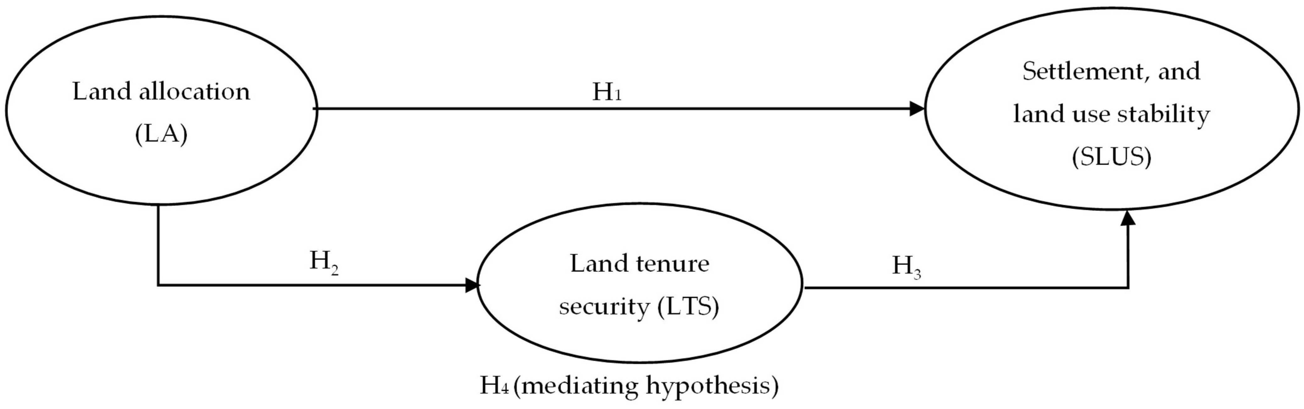
In this study, we examined direct effects, including LA effects on LUS, LA effects on LTS, and LTS effects on SLUS. We analyzed the mediating role of LTS in the relationship between the effect of LA on SLUS. In this relationship, LTS encompasses three components, de jure, perception, and de facto, and their interrelations. The following hypotheses were proposed and are illustrated in Figure 1.
Hypothesis 1 (H1).
LA positively influences SLUS.
Hypothesis 2 (H2).
LA positively influences LTS.
Hypothesis 3 (H3).
LTS positively influences SLUS.
Hypothesis 4 (H4).
LTS mediates the relationship between LA and SLUS.

3. Methods

3.1. Data Collection and Sampling Methods

Data on LA covering the 2019–2023 policy implementation period were obtained from relevant agencies in Binh Dinh Province during 2024–2025, when the study area was administratively under Binh Dinh Province; it is currently under Gia Lai Province following the July 2025 administrative restructuring. Data sources included the Department of Natural Resources and Environment (currently the Department of Agriculture and Environment), the Management Board of Investment Projects and Land Development Fund, the Ethnic Affairs Office (currently the Provincial Department of Ethnic Minorities and Culture), the Provincial Land Registration Office and its branch offices, as well as the People’s Committees of communes, wards, and townships (currently communes and wards) in Tay Son, An Lao, and Quy Nhon.
The scales for the concepts of LA, LTS, and SLUS were developed based on the results of published domestic and international research, adjusted to suit local practices by incorporating Vietnamese land law regulations and interview results from experienced individuals (Table 1). The LA scale comprises six observed variables that reflect the legal role of land allocation (LA2), the function of land allocation (LA1, LA5), and the socio-economic impact of land allocation on individuals (LA3, LA4, LA6). The LTS scale includes six observed variables reflecting de jure (LTS2, LTS3), de facto (LTS1, LTS4), and perceived security (LTS5, LTS6). The SLUS scale comprises five observed variables that focus on settlement and land use stability.

3.2. Expert Consultation Method

Based on a review of the published literature, we consulted six experts with knowledge in LA and the LURC of assets attached to land to determine indicators for three concepts relevant to local practices and to identify the relationships between these concepts. Based on the above, we developed a preliminary scale to measure the effect of LA on LTS and SLUS.

3.3. Field Investigation and Survey Methods

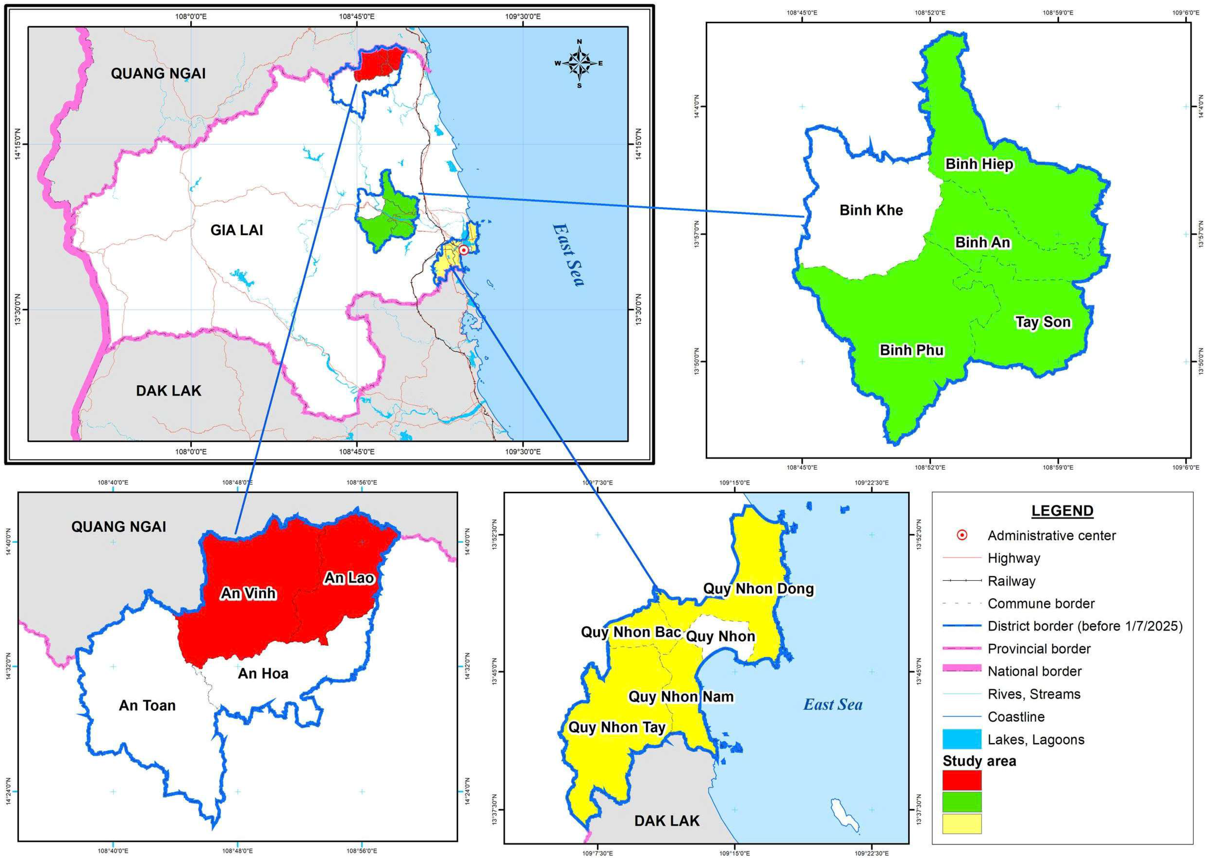
The study area was selected based on three criteria: (i) a high number of land parcels allocated to households and individuals, (ii) diversity of land users, and (iii) distinctive land use practices that enable analysis of the relationship between LA, LTS, and SLUS. Our research covered 15 communes and wards located in Quy Nhon, Tay Son, and An Lao areas (see Figure 2). During the data collection period—conducted over more than one year beginning in June 2024—these administrative units were situated within Quy Nhon City, Tay Son District, and An Lao District of Binh Dinh Province. In July 2025, pursuant to a nationwide administrative restructuring that included the abolition of the district level, these areas were incorporated into Gia Lai Province [13]. The selected sites span the three principal topographical zones of the former Binh Dinh Province—coastal, lowland, and mountainous—thereby ensuring spatial and ecological heterogeneity in the study design. Moreover, during the 2019–2023 policy implementation period, these areas recorded a comparatively higher number of land allocations to households and individuals than other localities within the same topographical categories, reinforcing their analytical relevance for assessing land allocation outcomes.
The preliminary scale was developed based on a literature review, combined with consultation and revision informed by the contributions of five relevant professional staff. Next, the official scale was finalized to serve as the basis for the survey, assessing the relationship between LA, LTS, and LUS. The survey sample size was determined based on Slovin’s formula (1) [40]:
n = N 1 + ( N e 2 )  
where n: Number of samples to be surveyed; e: allowable error (e = 0.05); N: Total number of individuals—total number of cases allocated land in the period 2019–2023. Although 6005 land allocation records were identified during the study period, after standardization and the exclusion of households allocated multiple land types, the final number of unique households receiving land allocation was 5611 (N = 5611), n = 373 survey samples. In addition, adopting a structural equation modeling (SEM) framework, the required sample size was determined using the inverse square root method [41], resulting in a target sample of 410 observations.
After excluding invalid questionnaires, a final dataset of 400 valid responses was retained for analysis. The samples were collected using stratified proportional sampling, with administrative areas serving as the stratification criterion, with An Lao, Tay Son, and Quy Nhon treated as independent strata.
Initially, the sample size for each area was determined proportionally, based on the ratio of households allocated land to the total study population. To ensure adequate statistical power for comparative analysis and to align with the analytical requirements of partial least squares structural equation modeling (PLS-SEM), the final sample design was subsequently adjusted toward a non-proportional (asymmetrical) stratification, with a deliberate increase in the number of observations from Tay Son, the area with the smallest number of land-allocated households. This sampling adjustment is appropriate for studies that prioritize the examination and comparison of relationships across strata rather than the estimation of population-level parameters, while also contributing to the stability of path coefficients and latent-variable relationships within the PLS-SEM framework [42,43].
Following this adjustment, the final sample consisted of 172 responses from An Lao (44.15%), 99 from Tay Son (24.39%), and 129 from Quy Nhon (31.46%). Field data were collected between June 2024 and July 2025 through face-to-face interviews with land users. Within each stratum, respondents were selected using simple random sampling from official lists of households and individuals allocated land during the period 2019–2023 as maintained by local authorities and land administration agencies.
Field data were collected through face-to-face interviews conducted between June 2024 and July 2025. To assess the level of agreement from the perspective of households and individuals on three scales, LA, LTS, and SLUS, we used a 5-point Likert scale, with levels from 1 (“completely disagree”) to 5 (“completely agree”). This scale structure is suitable for the response capacity of households and individuals in all three locations, An Lao, Quy Nhon, and Tay Son, helping to standardize subjective perceptions into quantitative data and facilitating the analysis of the research model.
During data screening, 10 questionnaires (>30% missing responses) were excluded in accordance with methodological guidance to remove cases with substantial missing data (>15%) [44]. Following this step, only a single missing value remained (<0.1% of total observations). This value was assessed as missing at random and imputed using mean substitution for the corresponding Likert-scale item. Given the trivial level of missing data, single-value imputation is unlikely to bias parameter estimates or compromise model validity, especially when the overall missing rate is substantially below the commonly accepted 5% threshold in SEM research [44,45]. The final dataset, comprising 400 valid observations, meets established methodological criteria for Structural Equation Modeling (SEM) and Partial Least Squares SEM (PLS-SEM) analysis [42,43].
This study was conducted in accordance with applicable national regulations and institutional policies. Under current Vietnamese regulations, formal ethics approval is not required for non-clinical, low-risk social science research of this nature. The study is therefore considered exempt from ethics committee review. Compliance with these ethical requirements was formally confirmed by the Scientific Council of the Faculty of Land Resources and Agricultural Environment, University of Agriculture and Forestry, Hue University. Before data collection, participants were informed of the study objectives, the voluntary nature of participation, and their right to withdraw at any time without penalty. A consent statement was included at the beginning of the questionnaire, and informed oral consent was obtained from all participants before the interviews. The study did not involve the collection of personally identifiable or sensitive information. All responses were treated confidentially and used exclusively for research purposes.

3.4. Methods for Processing Data

After collection, the data were entered, coded using Excel software, classified, and analyzed by content groups for literature review and preliminary scale design, adjustment, and completion of the official scale. IBM SPSS Statistics 26 software was used to process statistical data. Lastly, SmartPLS 3 software with SEM was used to calculate and examine the effect of LA on LTS and SLUS. Hair et al. [42] state that structural models should be evaluated after conducting measurement model evaluations when assessing the effect of LA on LTS, and SLUS. We evaluated the measurement model according to Hair’s guidelines to test the reliability and validity of the scale through the values of index reliability, internal consistency reliability, convergent reliability, and discriminant reliability. Scale reliability was ensured when Cronbach’s alpha, composite reliability (CR), and rho_A were equal to or greater than 0.70, with CR not exceeding 0.95. Convergent validity was established through outer loadings of at least 0.70 and an average variance extracted (AVE) of 0.50 or higher. Discriminant validity was assessed using the heterotrait–monotrait ratio (HTMT), with threshold values below 0.85, following Kline [46]. The structural model evaluation criteria are presented below based on the guidelines of Hair et al. [42] and Henseler et al. [47], including the assessment of multicollinearity (VIF < 3.3), coefficient of determination (R2 > 0.20) indicating acceptable explanatory power in social science research, and the significance of path coefficient (β), which were tested using bootstrapping with significance levels of p < 0.05 and p < 0.01.

4. Results

4.1. The Current Situation Regarding Land Allocation, Ensuring Land Tenure Security, Settlement, and Land Use Stability for Households and Individuals in the Study Area

In recent years, Vietnam’s land law and policy system has undergone significant adjustments to effectively allocate land to those in need, thereby establishing a legal framework between the State and land users. Research results show that from 2019 to 2023, in the communes, wards, and towns of An Lao, Tay Son, and Quy Nhon areas of Binh Dinh Province (administrative status at the time; currently communes and wards under Gia Lai Province following the July 2025 restructuring), LA to households and individuals was carried out for three main land types: production forest land (12,640,300.00 m2), residential land (709,269.92 m2), and paddy land (565,400.00 m2) (Table 2). Notably, only the communes and wards in the An Lao area allocated land for all three land types. In addition, the area of residential land allocated in An Lao is the largest among the three areas, with 315,700.00 m2, accounting for 44.51% of the total allocated residential land. In the communes and wards of Quy Nhon and Tay Son, LA has been carried out for rural and urban residential land, with the allocated area in Quy Nhon being 203,807.42 m2 (accounting for 28.74% of the total allocated residential land), and the area in Tay Son being 189,762.50 m2 (accounting for 26.75% of the total allocated residential land). In the communes and wards of the three aforementioned areas, LA has concretized the Party and State’s policy on ensuring access to land for land users, especially addressing the housing and production land needs of ethnic minorities in An Lao—a poor area of Gia Lai Province, where ethnic minorities account for over 70% of the population, mainly the H’re and Ba Na people.
Within the framework of public ownership of land in Vietnam, since the implementation of the 1992 Constitution, the Land Law has stipulated that the State allocates land to households and individuals (as referred to in the 2024 Land Law) associated with the right to transfer land use rights. Combining legal regulations and practical surveys, LTS is considered from three perspectives: de jure, de facto, and the perceived security of land users. Interviewees noted that the actual security perceived through regulations on not illegally reclaiming land and being adequately compensated when the State reclaims land helps safeguard legal land use rights, which plays a vital role for land users, as shown by the value of MeanLTS2 = 3.51 (Table 2). Concurrently, legal security plays a crucial role in enhancing LA and safeguarding land use rights through the issuance of an LURC, thereby ensuring that land users benefit from LA, encouraging investment, and promoting efficient land use (MeanLTS1 = 3.50). Furthermore, survey results show that land users’ participation in land management and use decisions contributes to enhancing land use rights and safeguarding rights (MeanLTS6 = 3.50), because land users believe their land use rights are respected. The results of a recent study by Sun et al. [4] also highlight this difference.
The data presented in Table 3 show that issuing an LURC helps minimize legal risks and disputes compared to LA without LURC. In comparison, an LURC is a condition ensuring the right to transfer land use rights; however, the results of the interviewees’ awareness of this issue are lower than other observed variables (MeanLTS3 = 3.45, MeanLTS4 = 3.38). Locally, for ethnic minority individuals from poor or near-poor households in An Lao area and who are allocated residential and production land under the land support policy, as stipulated in Article 40 of Decree 43/2014/ND-CP guiding the implementation of the 2013 Land Law, the right to transfer or donate land use rights can only be exercised after 10 years from the date of the LA decision and only when there is no longer a need for land use. At present, as stipulated by the 2024 Land Law, there is no time limit on the transfer of land use rights. However, there are limitations on the recipients of land use rights transfers for land allocated under land support programs. Accordingly, individuals belonging to ethnic minorities who are allocated land by the State are only allowed to inherit, gift, or transfer land use rights to heirs who are also ethnic minorities and are poor or near-poor households in ethnic minority and mountainous areas. Based on the opinions of 18 ethnic minority households participating in the survey, although this regulation is consistent with ensuring the provision of residential and production land, for those using land under the land support policy, the limitations on the recipients of land use rights transfers have created a feeling of constraint, thus resulting in a lower level of perceived security of ownership compared to other observed variables.
Regarding resettlement land, most households and individuals were granted LURCs after receiving resettlement plots. However, those participating in the Dong Mit Lake Resettlement Project (An Lao area) had not yet been issued LURCs as of October 2025. Although the issuance process has remained slow and ongoing for this group, surveyed households and individuals consistently reported that their land-use rights were perceived as secure. This perceived security is evidenced by their continued residential settlement and active engagement in agricultural production on the allocated plots, supported by state-provided technical guidance, seed selection assistance, and access to production credit. Among the 14 surveyed households and individuals allocated land under the Ho Dong Mit Resettlement Project in 2020, land was provided for both residential and productive purposes, and their land use rights have been recognized in practice by local authorities and the community. Despite the absence of formally issued LURCs as of October 2025—primarily due to differing interpretations and applications of legal provisions between tax authorities and local government agencies—these households and individuals reported a sustained perception of tenure security, reflected in stable settlements and continued agricultural production.
The data presented in Table 3 also indicate that respondents report positive perceptions of settlement and land use stability following LA. With the understanding that residential LA has a stable, long-term use period, and agricultural LA has a 50-year term with the possibility of continued use when needed, the majority of land users viewed land use rights as a sustainable asset that can be passed down through generations (MeanSLUS5 = 3.53). In addition, residential and resettlement areas in the study area have comprehensively invested in technical and social infrastructure, suitable to the living characteristics and customs of individuals, which has significantly contributed to the stability of housing and land use for those who have been allocated land (MeanSLUS4 = 3.51). A notable aspect of LA practice is the local government’s flexible application of beliefs and customs associated with the land parcels in the implementation of land law policies. This factor is demonstrated by the transportation of fertile topsoil from old fields to cover new production land areas in the An Lao area; support for the transportation of scrap materials from old houses to build house foundations in resettlement areas in the Tay Son area; and proactive consultation with residents when developing land use plans and constructing housing projects in all three areas: Quy Nhon, An Lao, and Tay Son. These actions reflect institutional recognition of, and respect for, cultural values associated with the “Land God” and “House God” embedded in local belief systems, thereby fostering a sense of familiarity and emotional attachment to the newly allocated land among residents (MeanSLUS3 = 3.45). The findings further indicate that the implementation of administrative measures aligned with local cultural practices not only reinforces perceptions of LTS but also strengthens public trust in local authorities’ law enforcement capacity, contributing to residents’ sense of stability and security following LA.

4.2. Assessing the Effect of Land Allocation, Land Tenure Security, Settlement, and Land Use Stability of Households and Individuals in the Study Area

4.2.1. Evaluation of Scale Reliability

We used three criteria to test the reliability of the scales, including Cronbach’s Alpha coefficient, composite reliability (CR), and rho_A coefficient. The results presented in Table 4 show that the Cronbach’s Alpha coefficient of all scales exceeded the threshold of 0.7 as recommended by Hair et al. [42]. Specifically, the Cronbach’s Alpha coefficient of the LA scale was 0.889, that of the LTS scale was 0.891, and that of the SLUS scale was 0.848 (Table 4). In PLS-SEM, CR is the preferred measure of internal consistency. In all cases, the composite reliability of the three scales listed in Table 4 (CRLA = 0.916, CRLTS = 0.917, and CRSed = 0.892) reached the recommended range of 0.7 to 0.95 of Hair et al. [42], showing that the observed variables in each scale meet the required reliability level. The above results demonstrate that the 17 observed variables across the three scales, LA, LTS, and SLUS, exhibit adequate factor representation, supporting the validity of the scale. The rho_A coefficient of the three scales (rho_ALA = 0.889, rho_ALTS = 0.892, and rho_ASLUS = 0.849) ensures the condition ≥0.7, reflecting the consistency of the observed variables (indices) in measuring the same latent concept as recommended by Dijkstra and Henseler [48]. Cronbach’s Alpha coefficient is equivalent to rho_A, demonstrating that the scale is stable and no variable has significant loading bias, thus proving that the scale ensures reliability.

4.2.2. Evaluation of Scale Convergence Value

We conducted a convergent validity assessment of the scale to determine the positive correlation of the seventeen observed variables with three latent variables: LA, LTS, and SLUS. The results of the convergent validity test of the scale are shown through the outloading coefficient, t-test, and extracted mean variance (AVE) [42].
For the land allocation scale (LA), the loading coefficients of the six observed variables presented in Table 5 are relatively uniform (from 0.777 to 0.828), ensuring ≥0.70 as suggested by Hair et al. [42], confirming that the LA scale has high reliability. Among them, variable LA4 has the most significant loading coefficient (0.828), most clearly representing the concept of LA in the six observed variables. This finding implies that cultural and social factors are key to the implementation and sustainable maintenance of LA policies at the local level.
The LTS scale demonstrates high reliability, with loading coefficients for the six observed variables ranging from 0.744 to 0.832, ensuring a loading coefficient of ≥0.70. Three observed variables, LTS4, LTS5, and LTS1, have high external loading coefficients of 0.832, 0.830, and 0.818, respectively. The issuance of an LURC, combined with the recognition of stable land use by local authorities and communities, underpins LTS by enabling the exercise of land-related rights, protecting users’ benefits, and encouraging long-term investment and efficient land use. The observed variable LTS6 = 0.744, but still exceeds the threshold of 0.7, implying that participation in land use and management decisions is a significant concern for land use.
The loading coefficients of the five observed variables of SLUS range from 0.747 to 0.831, ensuring a value greater than 0.70, indicating that the SLUS scale possesses strong reliability, as suggested by Hair et al. [42]. Two observed variables, SLUS1 and SLUS4, have high external loading coefficients of 0.831 and 0.804, respectively, showing that LA provides means of production to stabilize housing and production associated with the development of infrastructure and essential services, facilitating settlement and stable land use. The variable SLUS2, with an external loading coefficient of 0.791, shows that the allocation of residential and production land based on traditional settlement in villages and residential clusters contributes to maintaining community structure and encouraging long-term settlement, clearly demonstrated in rural areas, especially among ethnic minorities, wherein the custom of living in villages and hamlets is highly valued. Typically, in the Dong Mit Lake project, the allocation of resettlement land in clusters and villages for H’re and Bana ethnic minority households received high consensus from local people, mainly because the LA according to land use planning took into account the cultural traditions, customs, practices, and settlement patterns of ethnic minority villages and rural areas such as An Lao and Tay Son. However, this factor was of less significance in urban areas such as Quy Nhon, where LA is based on many factors, including land availability and land prices. It can be seen that LA according to functional zones still maintains community structure, encourages long-term settlement, and reduces the need for migration.
As shown in Table 5, all three scales, LA, LTS, and SLUS, have an external load factor reliability ≥0.70 based on the method of Hair et al. [42]. All observed variables of the three scales have t-values of the load factor ranging from 28.266 to 53.947, satisfying the condition of being more significant than the threshold of 2.57 for 1% statistical significance. This result confirms that the observed variables contribute significantly to the latent structure of LA, LTS, and SLUS. In addition, the values AVELA = 0.644, AVELTS = 0.649, and AVESLUS = 0.623 all satisfy the condition ≥0.5, meeting the convergence criterion, implying that the observed variables explain more than 62% of the variance of the three concepts of LA, LTS, and SLUS. This result reflects a relatively uniform understanding among individuals regarding the content and objectives of LA, in addition to its impact on LTS, and SLUS in the An Lao, Tay Son, and Quy Nhon areas of Gia Lai Province.
The path coefficient from construct LA to construct LTS is statistically significant (βLA→LTS = 0.512, tLA→LTS = 13.609, p < 0.001), with identical findings for the path coefficient from construct LA to construct SLUS (βLA→SLUS = 0.382, tLA→SLUS = 9.383, p < 0.001) and that from construct LTS to construct SLUS (βLTS→SLUS = 0.432, tLTS→SLUS = 10.539, p < 0.001) (see Table 6), thereby supporting the research hypotheses. In line with the guidelines of Hair et al. [42], the bootstrapping results demonstrate that the path relationships between LA and LTS, LA and SLUS, and LTS, and SLUS are statistically significant at the 1% level. This result proves that hypotheses H1, H2, and H3 are significant. Based on the results of the PLS-SEM model analysis, and according to the findings of Preacher et al. [49], this result includes both direct effects (βLA→SLUS = 0.382) and indirect effects through LTS (βLA→LTS = 0.512, βLTS→SLUS = 0.432, indirect effect βLA→SLUS = 0.512 × 0.432 = 0.221). The above results confirm that LA affects land users’ decisions regarding SLUS. The simultaneous presence of these two components indicates that land tenure security plays a mediating role in the relationship between LA and SLUS, thereby strengthening the model’s explanatory power for SLUS. Specifically, LA contributes to ensuring land tenure security (de jure, perception, and de facto) while also promoting SLUS.

4.2.3. Evaluation of the Discriminant Value of the Scale

The discriminant validity of the LA, LTS, and SLUS scales is presented in Table 7, as assessed using the heterotrait–monotrait ratio (HTMT) and cross-loading criteria. The results show that the HTMT values in the model range from 0.574 to 0.720, ensuring the condition is less than the threshold of 0.85 as suggested by Kline [46], reflecting significant differences between the constructs. The data indicate that the latent constructs LA, LTS, and SLUS in the model are discriminant; the scales accurately reflect the significance range of each concept, ensuring the necessary discriminant validity for the measurement model. The cross-loading results presented in Table 7 demonstrate that each load is stronger on its topology than on any other construct. These results confirm satisfactory discriminant validity according to the cross-loading criteria [42,50].

4.2.4. Testing the Structural Model of the Effect of Land Allocation on Land Tenure Security, Settlement, and Land Use Stability

To test the path coefficients in the structural model, we used the bootstrap technique-a repeated sampling method with substitution—to estimate the standard errors of the parameters without assuming a normal distribution [42]. As shown in Table 8, the maximum variance inflation factor (VIF) values for all latent constructs range from 2.156 to 2.466, which are below the recommended threshold of 3.3 proposed by Kock and Lynn [51]. This finding indicates that multicollinearity is not a concern in the estimated model. The estimated path coefficients are stable and reliable. The results presented in Table 8 show that the coefficient of determination, R2LTS = 0.262 and R2SLUS = 0.501, exceeds the threshold of 0.2 as recommended by Hair et al. [42] and is consistent with the results obtained in social science research. The adjusted R2 values of 0.261 and 0.499, respectively, reflect the explanatory power and acceptable consistency of the relationships in the model. These results demonstrate the completeness of the structural model and show that the assumed relationships between the structures are statistically significant and theoretically plausible.

5. Discussion and Policy Implications

To date, a number of studies on the LA, LTS, and SLUS of households and individuals have been conducted; however, rigorous quantitative evidence from Central Vietnam—particularly in the study areas administratively under Binh Dinh Province during the 2019–2023 period and currently under Gia Lai Province following the July 2025 administrative restructuring—remains limited. By employing SEM, this study provides robust empirical confirmation of the overall effect of LA on SLUS (β = 0.603), comprising a significant direct effect (β = 0.382) and an indirect effect mediated through LTS (βLA→LTS = 0.512; βLTS→SLUS = 0.432; indirect βLA→SLUS = 0.221). Our research results correlates with the findings of Deininger and Feder [31] and Tesfaye et al. [32] on LTS, in addition to the findings of Castella et al. [35] and Sun et al. [4] on settlement and land use stability and support the argument that the implementation of LA policies has contributed to concrete results in promoting the settled livelihood system of Le and Scott [52].
This finding also contributes to supplementing quantitative evidence for previous studies in which researchers mainly applied qualitative or descriptive appraoches, especially in the context of Central Vietnam, where natural conditions, culture, and land use history possess many unique characteristics. However, the findings indicate that the positive effects of LA are concentrated mainly among households and individuals who have already received land within the study area. By contrast, a segment of ethnic minority households continues to face constrained access to both residential and productive land. The divergence between the policy impacts identified through the empirical model and outcomes observed in practice can be attributed primarily to implementation-related constraints rather than shortcomings in policy design. These constraints include the limited availability of local land reserves; the obligation to implement land allocation in accordance with approved spatial planning frameworks and phased schedules; insufficient resources for land surveying, cadastral preparation, and allocation procedures; weaknesses in post-allocation land management; and the limited participation of land users in decision-making processes. Taken together, these factors restrict the coverage and equity of land allocation policies, despite their demonstrated effectiveness for households that have benefited from land allocation.
Comparative evidence from Central and Eastern Europe provides an important benchmark for understanding how different institutional trajectories shape the relationship between land allocation or privatization, land tenure security, and land use stability. Comparative analyses of agricultural reforms indicate that rapid market liberalization following 1989 generated highly divergent development outcomes, ranging from persistent land fragmentation to the reconsolidation of large-scale private farms, depending primarily on the effectiveness of land registration systems, dispute-resolution mechanisms, and overall administrative capacity [53,54]. In many Central and Eastern European contexts, formally established land use rights have not necessarily translated into de facto land tenure security, particularly where land registration systems remain incomplete and post-allocation governance frameworks are weak. As a result, land use practices tend to be short term, land-related investment remains limited, and settlement patterns exhibit greater instability [55], consistent with broader empirical evidence on the relationship between land tenure security and land investment behavior [56]. By contrast, evidence from Central Vietnam highlights the broader comparative significance of land governance systems in which the state plays a dominant role. The findings suggest that state-led land allocation, when combined with effective land registration and post-allocation management, can translate formal land rights into stronger land tenure security and support more stable land use decisions. Moreover, the results indicate that property rights theory can be applied adaptively within a system of public land ownership, in which land tenure security incorporates three interrelated components—de jure, de facto, and perceived security. This finding is consistent with those of Nguyen et al. [28] and Deininger [30], who emphasize the importance of ensuring LA policies that expand access to land and mitigate shortages for housing and production, while also extending the analytical perspective to include cognitive and perceived dimensions of security within Vietnam’s state ownership regime.
However, our results also revealed inconsistencies in land law enforcement, particularly in the relationship between financial obligations related to land and the issuance of an LURC, which have undermined the legal security of a segment of land users. This practice demonstrates that the effectiveness of LA policies depends not only on the initial LA decision but also significantly on post-allocation management mechanisms and the level of institutional coordination in law enforcement. Notably, the results show that integrating indigenous cultural elements, customs, and community structures into the LA process contributes to enhancing the actual and perceived safety of land users by strengthening trust, reducing conflict, and encouraging land users to settle and use the land stably. The results indicate that sustainable land management is inherently embedded in, and strongly shaped by, the local socio-cultural context. In the future, it will be neccessary for local authorities to unify land use rights verification plans, ensure the legal rights of land users, and improve land use efficiency, because, as suggested by Ege [57] and Gao et al. [58], this is a critical and time-sensitive measure to safegaurd the legal rights of land users and promote efficient land use. Furthermore, residential and agricultural land use planning should be closely aligned with local cultural contexts, preserving indigenous community structures while enhancing the productive capacity of allocated land parcels, thereby supporting long-term settlement and stable land use.
The findings indicate that although LURC strengthens LTS, land users’ perceived tenure security is jointly shaped by economic rights and the spatial stability of residence. In the An Lao area, policy-based restrictions on eligibility for land-use right transfers—intended to protect ethnic minority households from the risk of land loss—have nonetheless generated a sense of constraint among certain land users. This finding is consistent with studies on rights asymmetry, which suggest that perceptions of security depend not only on the formal existence of rights but also on their relative scope and completeness compared with those held by other social groups [59,60]. From a livelihood perspective, the impacts of these restrictions are differentiated. Households prioritizing residential stability tend to accept such constraints as protective mechanisms. In contrast, those with greater demands for economic flexibility perceive them as a reduction in autonomy over land-related decisions [56,61]. At the same time, the results show that ethnic minority households’ sense of security is closely tied to the spatial stability of settlement, particularly in the context of land acquisition and resettlement in Binh Dinh Province (now Gia Lai Province), where land recovery has primarily affected agricultural land, unused land, or informally established residential areas. By contrast, planned, legally allocated, and stably managed settlements over extended periods are generally less exposed to planning adjustments, thereby reinforcing confidence in the long-term security of land use rights, consistent with the argument advanced by Van Gelder [5]. From a policy perspective, these findings underscore the need to integrate long-term spatial planning with the effective realization of economic land rights, enabling LURC to translate into stronger LTS and SLUS [56,61].
The theoretical framework applied in this study effectively captures the post-allocation institutional effects of land policies on land tenure security, settlement, and land use stability. However, in highly urbanized contexts such as Quy Nhon City, land use dynamics are strongly influenced by market forces, particularly land prices and transaction-driven incentives, which are not fully addressed in the present analysis. Future research could strengthen the framework by incorporating urban-specific models and market-oriented variables. In addition, the cross-sectional design captures post-allocation perceptions at a single point in time and does not allow assessment of long-term sustainability. Longitudinal studies are therefore needed to examine land retention, land transfers, and spatial mobility in land use over time.

6. Conclusions

Our research results provide evidence of a positive relationship between LA and SLUS, including both direct and indirect impacts through the mediating variable, partly LTS. This result is supported by hypotheses H1, H2, and H3, which are statistically significant at the 1% level. LA positively impacts LTS, thereby contributing to the promotion of SLUS for land users (R2LTS = 0.262, R2SLUS = 0.501). This result indicates that LTS plays a partial mediating role in the relationship between LA and SLUS. Simultaneously, LTS is perceived through three aspects: de jure, perception, and de facto. The allocation of 13.9 million m2 of land in the study area during the period 2019–2023 met the land needs for housing and production of households and individuals, thereby contributing to strengthening LTS and supporting SLUS. The research findings also indicate that integrating customs and practices into LA has contributed to strengthening both the de facto and the perceived security of land users. However, limitations in coordination among management agencies continue to undermine legal security, highlighting the need to strengthen land use rights governance through an integrated approach in which de jure security provides the institutional foundation, de facto security ensures effective implementation, and perceived security reinforces trust in public institutions.
From a policy perspective, the findings suggest the importance of consolidate a coherent and stable land governance framework to strengthen post-allocation land rights. This entails improving land registration and LURC issuance mechanisms, advancing digital transformation in cadastral administration, and enhancing institutional capacity at the grassroots level to enforce LA and related post-allocation regulations. In parallel with these reforms, the land database system based on the VNPT-iLIS platform has been operational in Binh Dinh Province since 2023 under the direction of the Ministry of Natural Resources and Environment (now the Ministry of Agriculture and Environment). The study area was administratively under Binh Dinh Province at the time of implementation and is currently under Gia Lai Province following the July 2025 administrative restructuring. The system demonstrates the ability to integrate spatial and attribute-based cadastral data within a unified digital infrastructure while facilitating electronic linkages between land registration authorities and tax agencies. Nevertheless, persistent challenges related to data consistency, interoperability, and traceability underscore the need for deeper technological integration. Adopting geographic information systems (GIS) as a shared spatial reference framework, together with blockchain technology as an immutable layer for recording land allocation decisions and associated financial obligations, could enhance transparency, accountability, and inter-agency coordination in land administration and local revenue governance. Finally, the findings support incorporating LTS criteria into the evaluation of land governance performance, with land users’ satisfaction and trust in the public land tenure system serving as key assessment dimensions.

Author Contributions

Conceptualization, B.T.D.H., N.T.H. and N.H.N.; methodology, B.T.D.H., N.T.H. and N.H.N.; software, B.T.D.H.; validation, B.T.D.H.; formal analysis, B.T.D.H.; investigation, B.T.D.H.; resources, B.T.D.H.; data curation, B.T.D.H.; writing—original draft preparation, B.T.D.H., N.T.H. and N.H.N.; writing—review and editing, B.T.D.H., N.T.H., N.N.T. and N.H.N.; visualization, B.T.D.H.; supervision, N.T.H., N.N.T. and N.H.N.; project administration, B.T.D.H., N.T.H. and N.H.N.; funding acquisition, B.T.D.H. All authors have read and agreed to the published version of the manuscript.

Funding

This research received no external funding.

Institutional Review Board Statement

This study was conducted in accordance with the Declaration of Helsinki (2013) and internationally accepted ethical standards for research involving human participants. Ethical review and approval were waived because the study constitutes non interventional social science research, relying on questionnaire surveys and expert consultations, and involves minimal risk to participants. The study did not collect identifiable or sensitive personal data. The research design complies with applicable ethical guidelines and regulations for social science research in Vietnam.

Informed Consent Statement

Informed consent was obtained from all subjects involved in the study. Participation in the survey and expert consultations was entirely voluntary. All participants were informed of the study’s objectives, the use of the collected data for academic research purposes only, and their right to withdraw from the study at any time without any consequences.

Data Availability Statement

The original contributions presented in the study are included in the article, further inquiries can be directed to the corresponding author.

Acknowledgments

The authors acknowledge the partial support of Hue University under the Core Research Program, Grant No. NCTB.DHH.2026.05.

Conflicts of Interest

The authors declare no conflicts of interest.

References

  1. Maxwell, D.; Wiebe, K.D. Land Tenure and Food Security: A Review of Concepts, Evidence, and Methods; Land Tenure Center, University of Wisconsin–Madison: Madison, WI, USA, 1998. [Google Scholar]
  2. Santos, F.; Fletschner, D.; Savath, V.; Peterman, A. Can government-allocated land contribute to food security? Intrahousehold analysis of West Bengal’s microplot allocation program. World Dev. 2014, 64, 860–872. [Google Scholar] [CrossRef]
  3. Ye, L.; Huang, X.; Yang, H.; Chen, Z.; Zhong, T.; Xie, Z. Effects of dual land ownerships and different land lease terms on industrial land use efficiency in Wuxi City, East China. Habitat Int. 2018, 78, 21–28. [Google Scholar] [CrossRef]
  4. Sun, X.; Wang, J.; Rao, F. Land Tenure Security and Sustainable Land Investment: Evidence from National Plot-Level Data in Rural China. Land 2025, 14, 191. [Google Scholar] [CrossRef]
  5. Van Gelder, J.-L. What tenure security? The case for a tripartite view. Land Use Policy 2010, 27, 449–456. [Google Scholar] [CrossRef]
  6. Malik, S.; Roosli, R.; Tariq, F.; Salman, M. Land tenure security and resident’s stability in squatter settlements of Lahore. ARCHive-SR 2019, 3, 146–159. [Google Scholar] [CrossRef]
  7. Galiani, S.; Schargrodsky, E. Land Property Rights and Resource Allocation. J. Law Econ. 2011, 54, S329–S345. [Google Scholar] [CrossRef]
  8. Byamugisha, F. Securing Land Tenure and Easing Access to Land; African Center for Economic Transformation: Abidjan, Côte d’Ivoire, 2016; pp. 1–36. [Google Scholar]
  9. Bui, D.T.; Dao, D.M. Small-scale hydropower dams development: Pros and cons from impacts on locals’ livelihoods in Vietnam, Lao and Cambodia. Multidiscip. Sci. J. 2025, 7, 2025535. [Google Scholar] [CrossRef]
  10. Ministry of Natural Resources and Environment. Report No. 85/BC-BTNMT Assessment of the Implementation of the 2013 Land Law and Orientations for Amending the Land Law (For the Appraisal Work of the Ministry of Justice) Dated 3 August 2022; Ministry of Natural Resources and Environment: Hanoi, Vietnam, 2022. [Google Scholar]
  11. Phan, T.H.; Trang, N.T.Đ. Solutions to Enforcing the Regulations on Resettlement Due to Land Recovery. Can Tho Univ. J. Sci. 2013, 26, 75–82. [Google Scholar]
  12. Tran, T.T.; Nguyen, H.N.; Huynh, V.C. Assessment of Forestland and Forest Allocation in Huong Hoa District, Quang Tri Province. Hue Univ. J. Sci. Agric. Rural. Dev. 2019, 128, 93–105. [Google Scholar] [CrossRef]
  13. National Assembly of the Socialist Republic of Vietnam. Resolution No. 202/2025/QH15 on Rearranging Provincial-Level Administrative Units; National Assembly of the Socialist Republic of Vietnam: Hanoi, Vietnam, 2025. [Google Scholar]
  14. Standing Committee of the National Assembly. Resolution No. 1664/NQ-UBTVQH15 on the Arrangement of Commune-Level Administrative Units of Gia Lai Province in 2025; Standing Committee of the National Assembly: Hanoi, Vietnam, 2025. [Google Scholar]
  15. The National Assembly of the Socialist Republic of Vietnam. Land Law No. 31/2024/QH15; The National Assembly of the Socialist Republic of Vietnam: Hanoi, Vietnam, 2024. [Google Scholar]
  16. Holden, S.; Otsuka, K.; Deininger, K. Land Tenure Reform in Asia and Africa: Assessing Impacts on Poverty and Natural Resource Management; Springer: Dordrecht, The Netherlands, 2013. [Google Scholar]
  17. Simbizi, M.C.D.; Bennett, R.M.; Zevenbergen, J. Land tenure security: Revisiting and refining the concept for Sub-Saharan Africa’s rural poor. Land Use Policy 2014, 36, 231–238. [Google Scholar] [CrossRef]
  18. Nguyen, T.T. Land tenure and land acquisition enforcement in Vietnam. Sage Open 2023, 13, 21582440231163102. [Google Scholar] [CrossRef]
  19. Abdulai, R.T.; Ochieng, E. Land registration and landownership security: An examination of the underpinning principles of registration. Prop. Manag. 2017, 35, 24–47. [Google Scholar] [CrossRef]
  20. Sjaastad, E.; Bromley, D.W. Indigenous land rights in Sub-Saharan Africa: Appropriation, security and investment demand. In The Economics of Land Use; Routledge: London, UK, 2017; pp. 425–438. [Google Scholar]
  21. Tran, T.V.A. Women and rural land in Vietnam. In Women’s Rights to House and Land: China, Laos, Vietnam; UN-Habitat: Nairobi, Kenya, 1999; pp. 95–114. [Google Scholar]
  22. Lopez, C.W.; Spears, E.; Hartwick, T.C.; Killough, J.C.; Schuett, M.A. Redefining Absentee: Towards Understanding Place Attachment and Stewardship in Non-Residential Landowners in Texas, USA. Geographies 2024, 4, 95–114. [Google Scholar] [CrossRef]
  23. Food and Agriculture Organization of the United Nations (FAO). Land Tenure and Rural Development; FAO: Rome, Italy, 2002. [Google Scholar]
  24. Keovilignavong, O.; Suhardiman, D. Linking land tenure security with food security: Unpacking farm households’ perceptions and strategies in the rural uplands of Laos. Land Use Policy 2020, 90, 104260. [Google Scholar] [CrossRef]
  25. Gebre, S.L.; Cattrysse, D.; Alemayehu, E.; Van Orshoven, J. Multi-criteria decision-making methods to address rural land allocation problems: A systematic review. Int. Soil Water Conserv. Res. 2021, 9, 490–501. [Google Scholar] [CrossRef]
  26. Levine-Schnur, R.; Ferdman, A. On the Just Distribution of Land Use Rights. Can. J. Law Jurisprud. 2015, 28, 317–342. [Google Scholar] [CrossRef]
  27. Nguyen, T.H.; Nguyen, C.M.H.; Nguyen, P.K. Current status of land allocation and lease to economic organizations in Lam Dong province. Hue Univ. J. Sci. Agric. Rural. Dev. 2019, 128, 109–119. [Google Scholar] [CrossRef]
  28. Nguyen, T.L.; Doan, T.Q.T.; Pham, T.L.T. Assessment of land use and management situation of ethnic minority villages in Krong Pa district, Gia Lai province. Can Tho Univ. J. Sci. 2023, 59, 203–212. [Google Scholar] [CrossRef]
  29. Pham, T.; Tran, N.; Kull, C.; Shackleton, R.; Cochard, R.; Nguyen, T.; Ngo, T.; Nguyen, T.; Tran, Q.; Vu, T. Factors influencing farmers’ forestland-use changes over 15 years (2005–2020) in Thua Thien Hue province, Vietnam. Int. For. Rev. 2023, 25, 71–91. [Google Scholar] [CrossRef]
  30. Deininger, K.W. Land Policies for Growth and Poverty Reduction; World Bank: Washington, DC, USA, 2003. [Google Scholar]
  31. Deininger, K.; Feder, G. Land registration, governance, and development: Evidence and implications for policy. World Bank Res. Obs. 2009, 24, 233–266. [Google Scholar] [CrossRef]
  32. Tesfaye, B.; Lengoiboni, M.; Zevenbergen, J.; Simane, B. Rethinking the Impact of Land Certification on Tenure Security, Land Disputes, Land Management, and Agricultural Production: Insights from South Wello, Ethiopia. Land 2023, 12, 1713. [Google Scholar] [CrossRef]
  33. Ma, X.; Heerink, N.; Feng, S.; Shi, X. Farmland tenure in China: Comparing legal, actual and perceived security. Land Use Policy 2015, 42, 293–306. [Google Scholar] [CrossRef]
  34. Deininger, K.; Jin, S. Securing property rights in transition: Lessons from implementation of China’s rural land contracting law. J. Econ. Behav. Organ. 2009, 70, 22–38. [Google Scholar] [CrossRef]
  35. Castella, J.-C.; Boissau, S.; Thanh, N.H.; Novosad, P. Impact of forestland allocation on land use in a mountainous province of Vietnam. Land Use Policy 2006, 23, 147–160. [Google Scholar] [CrossRef]
  36. Kosec, K.; Ghebru, H.; Holtemeyer, B.; Mueller, V.; Schmidt, E. The effect of land access on youth employment and migration decisions: Evidence from rural Ethiopia. Am. J. Agric. Econ. 2018, 100, 931–954. [Google Scholar] [CrossRef]
  37. Nguyen, V.Q.; Nguyen, T.V.; Trang, H.D.; Nguyen, T.C. The resettlement of the Son La hydropower project perspective practices and customfarming practices of the ethnic minority in the Northwest. J. Sci. Dev. 2011, 9, 985–993. [Google Scholar]
  38. Le, T.T.L. Livelihoods of people living in hydroelectric lakebed at a resettlement area in Lai Chau and an experienced lesson for Thanh Hoa people. Cult. Arts Mag. 2022, 3, 20–29. [Google Scholar]
  39. Downing, T.E.; Shi, G.; Zaman, M.; Garcia-Downing, C. Improving post-relocation support for people resettled by infrastructure development. Impact Assess. Proj. Apprais. 2021, 39, 357–365. [Google Scholar] [CrossRef]
  40. Slovin, M.B.; Sushka, M.E. A note on the evidence on alternative models of thebanking firm: A cross section study of commercial loan rates. J. Bank. Financ. 1984, 8, 99–108. [Google Scholar] [CrossRef]
  41. Kock, N.; Hadaya, P. Minimum sample size estimation in PLS-SEM: The inverse square root and gamma-exponential methods. Inf. Syst. J. 2016, 28, 227–261. [Google Scholar] [CrossRef]
  42. Hair, J.F., Jr.; Hult, G.T.M.; Ringle, C.M.; Sarstedt, M. A Primer on Partial Least Squares Structural Equation Modeling (PLS-SEM); Sage Publications: Thousand Oaks, CA, USA, 2017. [Google Scholar]
  43. Hair, J.F., Jr.; Black, W.C.; Babin, B.J.; Anderson, R.E. Multivariate Data Analysis; Cengage: Boston, MA, USA, 2019. [Google Scholar]
  44. Hair, J.F., Jr.; Hult, G.T.M.; Ringle, C.M.; Sarstedt, M.; Danks, N.P.; Ray, S. Partial Least Squares Structural Equation Modeling (PLS-SEM) Using R: A Workbook; Springer Nature: Berlin/Heidelberg, Germany, 2021. [Google Scholar]
  45. Ringle, C.M.; Sarstedt, M.; Sinkovics, N.; Sinkovics, R.R. A perspective on using partial least squares structural equation modelling in data articles. Data Brief 2023, 48, 109074. [Google Scholar] [CrossRef] [PubMed]
  46. Kline, R.B. Principles and Practice of Structural Equation Modeling; Guilford Publications: New York, NY, USA, 2023. [Google Scholar]
  47. Henseler, J.; Ringle, C.M.; Sinkovics, R.R. The use of partial least squares path modeling in international marketing. In New Challenges to International Marketing; Emerald Group Publishing Limited: Leeds, UK, 2009; pp. 277–319. [Google Scholar] [CrossRef]
  48. Dijkstra, T.K.; Henseler, J. Consistent partial least squares path modeling. MIS Q. 2015, 39, 297–316. [Google Scholar] [CrossRef]
  49. Preacher, K.J.; Rucker, D.D.; Hayes, A.F. Addressing moderated mediation hypotheses: Theory, methods, and prescriptions. Multivar. Behav. Res. 2007, 42, 185–227. [Google Scholar] [CrossRef]
  50. Chin, W.W. The Partial Least Squares Approach to Structural Equation Modeling. In Modern Methods for Business Research; Marcoulides, G.A., Ed.; Psychology Press: Mahwah, NJ, USA, 1998; pp. 295–336. [Google Scholar]
  51. Kock, N.; Lynn, G.S. Lateral collinearity and misleading results in variance-based SEM: An illustration and recommendations. J. Assoc. Inf. Syst. 2012, 13, 546–580. [Google Scholar] [CrossRef]
  52. Le, T.V.H.; Scott, S. Coastal livelihood transitions: Socio-economic consequences of changing mangrove forest management and land allocation in a commune of central Vietnam. Geogr. Res. 2008, 46, 62–73. [Google Scholar] [CrossRef]
  53. Swinnen, J.F.; Mathijs, E. Agricultural privatisation, land reform and farm restructuring in Central and Eastern Europe: A comparative analysis. In Agricultural Privatization, Land Reform and Farm Restructuring in Central and Eastern Europe; Routledge: London, UK, 2018; pp. 333–371. [Google Scholar]
  54. Hartvigsen, M. Land reform and land fragmentation in Central and Eastern Europe. Land Use Policy 2014, 36, 330–341. [Google Scholar] [CrossRef]
  55. Wehrmann, B. Governance of Land Tenure in Eastern Europe and the Commonwealth of Independent States (CIS); Food and Agriculture Organization of the United Nations: Rome, Italy, 2010. [Google Scholar]
  56. Deininger, K.; Jin, S. Tenure security and land-related investment: Evidence from Ethiopia. Eur. Econ. Rev. 2006, 50, 1245–1277. [Google Scholar] [CrossRef]
  57. Ege, S. Land tenure insecurity in post-certification Amhara, Ethiopia. Land Use Policy 2017, 64, 56–63. [Google Scholar] [CrossRef]
  58. Gao, X.; Shi, X.; Fang, S. Property rights and misallocation: Evidence from land certification in China. World Dev. 2021, 147, 105632. [Google Scholar] [CrossRef]
  59. Ribot, J.C.; Peluso, N.L. A theory of access. Rural. Sociol. 2003, 68, 153–181. [Google Scholar] [CrossRef]
  60. Lund, C. Rule and Rupture: State Formation through the Production of Property and Citizenship. In Rule and Rupture: State Formation Through the Production of Property and Citizenship; Lund, C., Ed.; Wiley-Blackwell: Oxford, UK, 2017. [Google Scholar] [CrossRef]
  61. Holden, S.T.; Ghebru, H. Land tenure reforms, tenure security and food security in poor agrarian economies: Causal linkages and research gaps. Glob. Food Secur. 2016, 10, 21–28. [Google Scholar] [CrossRef]
Figure 1. Research model.
Geographies 06 00027 g001
Figure 2. Map of communes and wards in the study areas (An Lao, Quy Nhon, and Tay Son), currently under Gia Lai Province, Vietnam, following the July 2025 provincial consolidation.
Geographies 06 00027 g002
Table 1. Scale for measuring concepts related to LA, LTS, and SLUS.
EncodeScale ContentRelated Research
The scale of land allocation (LA)
LA1LA is the efficient distribution of land resources[25,26]
LA2The State issues a land allocation decision to grant land use rights to subjects needing land use[15,27]
LA3LA enables land users to expand their land funds for housing and productionRecommended by the authors
LA4LA is important in the inheritance, development, and modification of farming methods and land use practices[28,29]
LA5LA policy contributes to increasing land access opportunities for land users[30]
LA6LA policy helps mitigate the shortage of residential and production land[28]
The scale of land tenure security (LTS)
LTS1Strengthening LTS through the issuance of an LURC ensures that land users enjoy the fruits of their labor, encouraging long-term investment and promoting efficient land use[31,32]
LTS2Regulations prohibiting the illegal recovery of land and ensuring proper compensation when the State recovers land help ensure the legal use of land[33]
LTS3Land plots granted an LURC help reduce legal risks and disputes compared to land plots not granted an LURC [34]
LTS4A plot of land with a valid LURC is a prerequisite for ensuring the rights to exchange, transfer, inherit, donate, mortgage, and contribute land use rights as capital[15]
LTS5Local authorities and communities acknowledge that stable land use enhances LTS[20]
LTS6Land users are given input into land management and use decisions, contributing to improving land tenure securityRecommended by the authors
The scale of settlement, and land use stability (SLUS)
SLUS1LA provides housing and means of production, creating a stable foundation for long-term settlement and land-based livelihoods[4,35]
SLUS2The allocation of residential and production land to residential clusters helps maintain community structure and reduce the need for migration[36,37]
SLUS3LA based on customs and cultural practices, closely linked to local production methods, strengthens the user’s attachment to the land and place of residence[37,38]
SLUS4LA is closely tied to the development of infrastructure and essential services, creating conditions for a stable and sustainable life and production[39]
SLUS5LA contributes to maintaining and accumulating land assets, creating conditions for future generations to inherit and develop the family’s residence and productionRecommended by the authors
Table 2. Results of LA to households and individuals in the study area during the period 2019–2023.
Land TypeAreaNumber of Land Plots Allocated (Plots)Percentage of Plots by Land Type (%)Area of Land
Allocated (m2)
Percentage of Area by Land Type (%)Number of Households Allocating Land
(Households)
Total 637410013,914,969.921006005
Production forest landAn Lao201810012,640,300.001001714
Paddy landAn Lao278100565,400.00100278
Residential landAn Lao104425.60315,700.0044.511044
Tay Son118629.08189,762.5026.751140
Quy Nhon184845.32203,807.4228.741829
Source: Binh Dinh Provincial Department of Natural Resources and Environment (prior to July 2025; currently the Gia Lai Provincial Department of Agriculture and Environment following administrative restructuring).
Table 3. Opinions of land users on ensuring LTS, and SLUS for allocated land parcels in the study areas.
EncodeMeanEncodeMean
LTS13.50SLUS13.39
LTS23.51SLUS23.29
LTS33.45SLUS33.45
LTS43.38SLUS43.51
LTS53.42SLUS53.53
LTS63.50
Source: Results of running the model using IBM SPSS Statistics 26 software.
Table 4. The results of the evaluation of the reliability of the scale.
ScalesCronbach’s AlphaCRrho_A
Land allocation (LA)0.8890.9160.889
Land tenure security (LTS)0.8910.9170.892
Settlement, and land use stability (SLUS) 0.8480.8920.849
Source: Model results obtained using SmartPLS 3 software.
Table 5. Scale items and latent variable evaluation.
ScaleOuter Loadingst-ValueScale ContentOuter
Loadings
t-ValueScale ContentOuter Loadingst-Value
Land allocation (LA), AVELA = 0.644Land tenure security (LTS),
AVELTS = 0.649
Settlement, and land use stability (SLUS), AVESLUS = 0.623
LA10.81845.453LTS10.81844.267SLUS10.83153.947
LA20.77737.738LTS20.79439.092SLUS20.79139.097
LA30.80338.481LTS30.81349.360SLUS30.77138.947
LA40.82845.893LTS40.83250.403SLUS40.80447.526
LA50.79540.707LTS50.83052.285SLUS50.74730.451
LA60.79233.234LTS60.74428.266
Source: Model results obtained using SmartPLS 3 software.
Table 6. Path coefficients and significance levels.
Relationshipβt-Valuep-ValueStatistical Significance Level
LA → LTS0.51213.6090.0001%
LTS → SLUS0.43210.5390.0001%
LA → SLUS0.3829.3830.0001%
Total effect LA→SLUS0.603
Source: Model results obtained using SmartPLS 3 software.
Table 7. Results of Discriminant validity testing using HTMT ratios and Cross-loading criteria.
RelationshipHTMTLAHTMTLTSHTMTSLUSCross LoadingsDiscriminant Validity
LA 0.777–0.828Achieved
LTS0.574 0.744–0.832Achieved
SLUS0.6930.720 0.747–0.831Achieved
Source: Model results obtained using SmartPLS 3 software.
Table 8. Structural model testing of the scale.
Latent VariablesMaximum VIF ValueR2Adjusted R2
LA2.288
LTS2.4660.2620.261
SLUS2.1560.5010.499
Source: Model results obtained using SmartPLS 3 software.
Disclaimer/Publisher’s Note: The statements, opinions and data contained in all publications are solely those of the individual author(s) and contributor(s) and not of MDPI and/or the editor(s). MDPI and/or the editor(s) disclaim responsibility for any injury to people or property resulting from any ideas, methods, instructions or products referred to in the content.