1. Introduction
Urban transformations represent complex phenomena whose analysis necessitates an inherently multidisciplinary approach, as they respond to needs embedded within a layered spatial and temporal context. Over time, these transformations acquire symbolic, identity-related, and landscape values, with their genesis and development being simultaneously influenced by historical, cultural, technical, and environmental factors [
1,
2].
Within these phenomena, historical infrastructures have been pivotal elements, assuming a dual function: on one hand, they acted as active drivers of settlement dynamics; on the other hand, they guided the historical stratification and relationships between humans, territory, and the essential resources for survival. From the earliest stages of human settlement, the management of natural resources has conditioned both the location and the form of the city, with water resources playing a central role in this process [
3,
4,
5].
Natural systems, such as streams, rivers, and lakes, along with artificial water systems such as cisterns, canals, underground tunnels, wells, and fountains, have guided the development of historical cities, functioning both as functional and morphogenetic devices capable of shaping the urban fabric over time and orienting its expansion.
In addition to their operational dimension, historical water infrastructures serve as primary documentary tools of great significance. Their presence beneath the ground or in the landscape, often partially concealed or neglected, allows for the interpretation of the city’s historical transformations in terms of technological adaptation, shifts in settlement patterns, and changes in environmental relationships. In this regard, these infrastructures can be seen as historical archives of urban transformations, capable of narrating the relationships between society, construction techniques, and the environment.
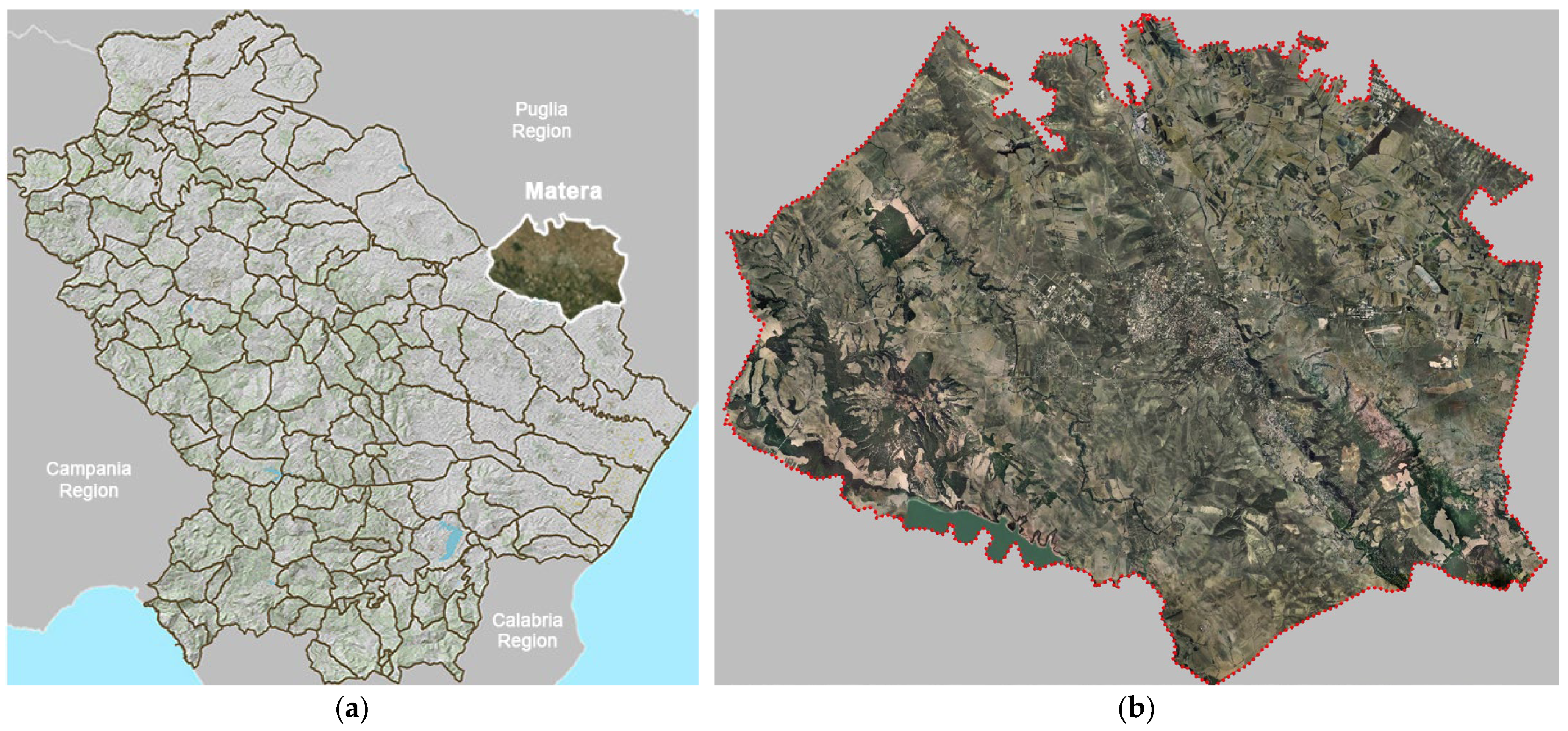
The case of Matera’s territory (
Figure 1a,b) stands as a paradigmatic example on the international stage, showcasing the exceptional integration of natural and built environments, emphasizing the deep interconnection between historical infrastructures and social organization [
1,
3,
4,
5,
6,
7,
8,
9,
10,
11].
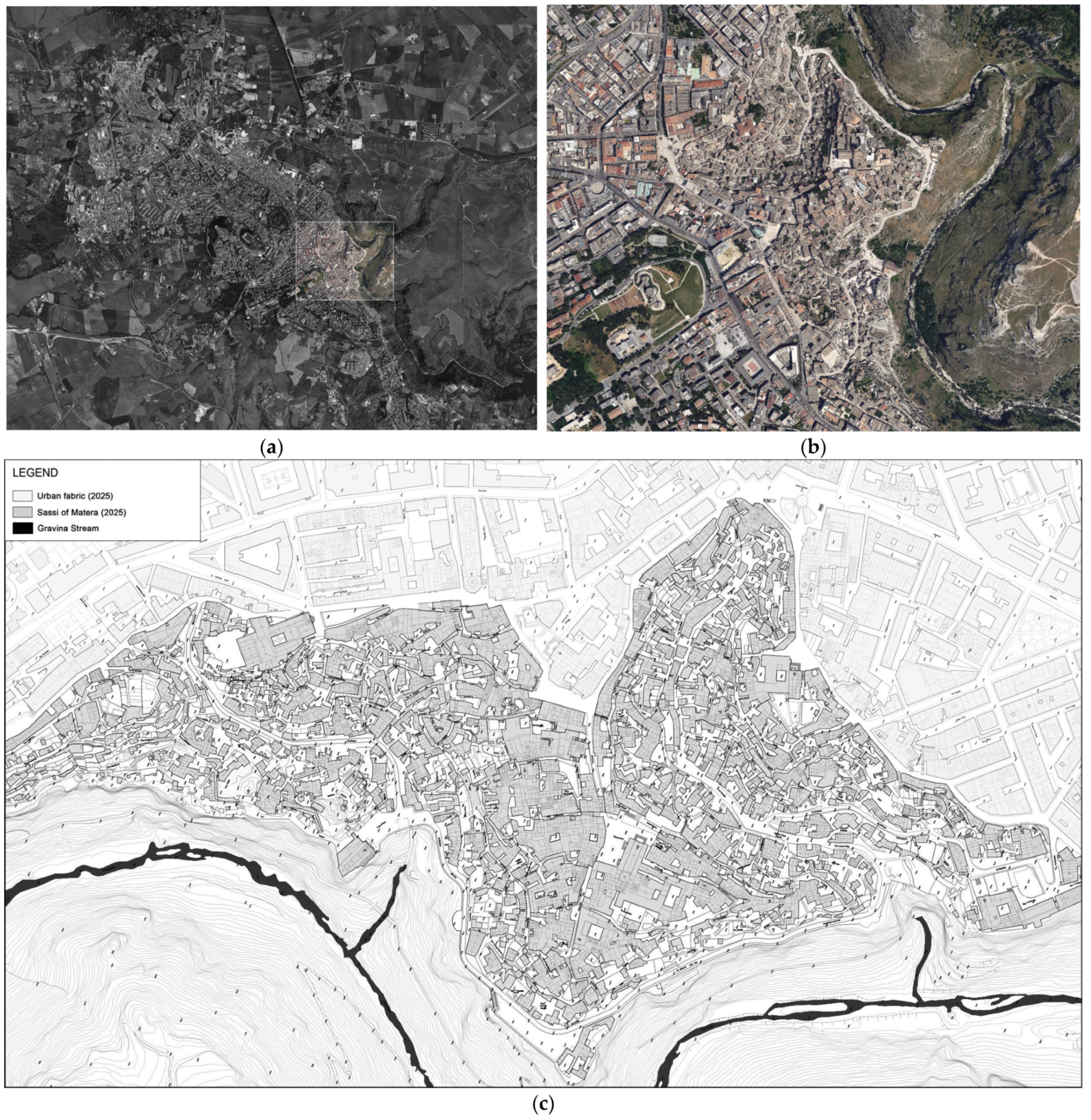
The historical urban fabric of the
Sassi (
Figure 2a–c) still retains significant water infrastructures that have undergone irreversible transformations, erasing their historical identity and original cultural value [
1,
3,
5,
6,
12,
13,
14].
Despite the extraordinary legacy of the so-called “rock culture” of Matera [
3,
4,
5,
7,
8,
9,
10,
11], which led to the inclusion of the
Sassi in the UNESCO World Heritage List in 1993, the current urban configuration remains largely altered from its original state. The most significant transformation has undoubtedly been the covering of the two natural streams of the
Grabiglioni, or
Fossi, small streams embedded within the urban fabric of Matera, which historically served the dual function of channeling and draining stormwater and wastewater [
1,
3,
6,
11,
12,
13,
14].Recovering the historical memory of the now-inaccessible
Grabiglioni water infrastructures allows for the rediscovery of the architectural and engineering value of these structures, which have fallen into oblivion. This process also unveils a “hidden” dimension of Matera’s identity, capable of enriching both tourist narratives and educational paths, revealing a profound and ancestral dialogue between human, stone, and water. Such infrastructures can become central nodes of interpretive itineraries, educational activities, and participatory practices, promoting a conscious and inclusive engagement with the historical heritage.
2. Materials and Methods
The methodological Logical Framework Approach (LFA) underpinning this research has been designed to address the inherent complexity of the
Grabiglioni systems in Matera, whose historical, spatial, and environmental dimensions demand an integrative and cross-disciplinary process (
Figure 3a). The LFA adopted in the present study stems from a fundamental and inescapable condition: the complete physical inaccessibility of the historical water infrastructures under investigation. This absolute inaccessibility has rendered all conventional direct survey techniques unfeasible, from the use of optical and laser instruments (such as distance meters and leveling tools to the most advanced three-dimensional mapping technologies, including any terrestrial or mobile LiDAR systems, laser scanners, and GeoSLAM devices (FARO, Dresden, Germany)). As a result, neither direct exploration nor remote scanning can be applied to the case studies considered.
It is precisely this material impossibility of physically accessing the structures that necessitated the adoption of an alternative methodological approach, grounded in the critical analysis and redrawing of archival historical documentation. Through an in-depth investigation of original technical drawings, written reports, thematic maps, and other coeval sources, the study aims to reconstruct, with the highest degree of scientific rigor, the morphological and functional configuration of the infrastructures in question.
The interpretation of these historical documents, often drafted according to now-obsolete graphic conventions and referring to technical-construction contexts that have profoundly changed, requires not only advanced expertise in historical-technical domains but also particular attention to geometric coherence and to the cross-referencing of heterogeneous sources. Redrawing, therefore, becomes not merely a tool for visual representation, but a genuine instrument of scientific inquiry, capable of compensating for the total absence of field-collected data.
In this sense, the methodology presented here (
Figure 3a) constitutes both an obligatory response and a scientifically grounded solution to an exceptional research condition, in which physical inaccessibility is not merely an operational constraint, but the very premise upon which the entire investigative framework is built.
Rooted in the premise that historical water infrastructures constitute not only technical artifacts but also cultural and territorial palimpsests, the proposed methodology unfolds through a four-step sequence, each interlinked and cumulatively generative (
Figure 3b).
The data identification step serves as the epistemological foundation of the study. It delineates the central research questions, motivates the adoption of a multidisciplinary perspective, and articulates the scientific objectives pursued. This stage orients the entire inquiry, establishing a conceptual coherence across diverse domains of knowledge.
The data acquisition step operationalizes the research by gathering the empirical and documental materials required for subsequent analyses. This phase is articulated into three sub-stages: an extensive bibliographic review, aimed at framing the study within the existing body of knowledge; a targeted archival research, focused on retrieving historical documentation relevant to the evolution of the
Grabiglioni; and an on-site survey, intended to capture the current physical and environmental conditions of the area under investigation (
Figure 3b).
The data development step concerns the transformation of raw data into analytical assets. This is achieved through: the digitalization of historical archival documents, ensuring their preservation and accessibility; the graphic vectorization of technical drawings and plans extracted from these documents, enabling spatial analysis and cross-referencing; the hydromorphic inspection aims to characterize the physical configuration of the
Grabiglioni and to evaluate their current functional condition and environmental significance. Through this structured methodology, the research aspires to bridge historical interpretation and technical assessment, fostering a renewed understanding of the
Grabiglioni not only as vestiges of the past, but as infrastructural elements with renewed relevance for contemporary urban resilience and cultural heritage enhancement (
Figure 3b).
2.1. Data Identification
The process of data identification in the present study emerges as a foundational step toward structuring a coherent and scientifically robust investigation.
The proposed study is guided by a series of interrelated research questions aimed at elucidating both the tangible and intangible dimensions of the Grabiglioni: what historical, morphological, and hydrological trajectories have shaped the Grabiglioni and their interaction with the urban structure of Matera? How have successive urban transformations contributed to the marginalization or obfuscation of these infrastructures? What is the cultural, technical, and environmental significance of these systems within the broader historical landscape? In what ways can the reactivation or reinterpretation of the Grabiglioni serve contemporary urban challenges, particularly those related to sustainability, risk mitigation, and identity-driven regeneration?
The inherent complexity of the research object necessitated a methodological departure from disciplinary silos. The multidisciplinary approach adopted in this study arises from the conviction that no single field of knowledge can, in isolation, fully capture the multifaceted reality of the Grabiglioni. The intersection of urban morphology, hydrology, historical cartography, cultural heritage studies, and infrastructure analysis allows for the construction of a comprehensive interpretative framework.
This integrative perspective is not merely additive but generative, enabling the formulation of insights that emerge precisely from the tensions, overlaps, and complementarities between disciplines. Furthermore, such an approach aligns with the growing recognition in heritage and urban studies of the need to address infrastructural legacies as living systems embedded in dynamic socio-environmental contexts.
By identifying and cross-referencing data from diverse disciplinary domains, the research aims to achieve the following objectives: reconstruct the historical development of the Grabiglioni streams and their role in shaping Matera’s urban fabric; assess the extent and nature of the transformations these infrastructures have undergone, particularly in light of modern urbanization processes; reframe the Grabiglioni not merely as obsolete or hidden infrastructures, but as active cultural and environmental assets with the potential to inform future urban planning; propose a methodological model that can be transferred to other case studies involving inaccessible or forgotten historical water systems.
2.2. Data Acquisition
This investigative step is divided into three sub-steps: a bibliographic search, an archival search and an in situ survey. Starting from a review of the previously developed scientific literature [
5], which outlined the comprehensive framework of the historical integrated water management system in Matera, considered in its entirety and across the various subsystems it comprises, the focus was then specifically directed towards the
Grabiglioni subsystems. In this regard, the study proceeded with the acquisition of archival historical documents held at the Municipal Archive and the State Archive of Matera, aiming to critically integrate literature sources with previously unpublished historical data.
In addition to the documentary sources, an on-site survey was carried out with the dual purpose of collecting updated photographic documentation and conducting direct measurements of key geometrical references. The latter proved essential for the subsequent verification of the reliability and consistency of the historical technical drawings acquired through archival research. Direct observation of the context also enabled the identification of potential discrepancies between the current state and the historical representation of the infrastructures, thereby providing a more comprehensive and reliable understanding of the physical and morphological conditions of the Grabiglioni systems.
It is important to clarify that the on-site measurements conducted as part of this study were limited exclusively to the urban surface context, including streets and other accessible elements of the contemporary cityscape. The subterranean infrastructure system of the Grabiglioni, as previously stated, remains entirely inaccessible due to its current physical condition. Consequently, no direct surveying activities were undertaken within the hypogeal structures themselves. All metric data pertaining to the surface environment were acquired with the sole purpose of contextualizing and georeferencing the archival materials, thereby establishing a coherent spatial framework within which to interpret, reconstruct, and analyze the historical water infrastructure network.
2.3. Data Development
The data development step constitutes a critical stage in the methodological trajectory of this research, aimed at transforming the heterogeneous corpus of raw data, collected through bibliographic review, archival exploration, and field surveys, into structured analytical content.
This step unfolds through a sequence of interrelated operations, each contributing to the progressive refinement and activation of the acquired information. First, the digitalization of the archival documents ensures the long-term preservation, accessibility, and replicability of fragile historical sources. Particular attention has been paid to technical drawings, cadastral maps and urban planning schemes, which provide a graphic substratum for subsequent spatial analyses.
Following digitalization, the graphic vectorization of technical drawings and cartographic material was undertaken. This process not only facilitates the spatial reinterpretation of historical layouts, but also allows for the integration of such materials within contemporary CAD and GIS-based tools and platforms. Vectorization serves as a critical bridge between analog representations of the past and the digital instruments of present-day spatial analysis, enabling precise overlay, scaling, and morphological comparison with current conditions.
A third and equally fundamental component of this method is the hydromorphic inspection, which represents a fundamental step in the interpretation of the genesis, evolution, and function of historical water infrastructures within the urban fabric. It is divided into two complementary components: the morphological analysis, which focuses on the study of the territory’s shape and its topographic organization, and the hydrographic analysis, aimed at reconstructing the historical and current dynamics of surface and underground water flow [
1,
12].
The hydromorphic approach relies on the fundamental concepts of watershed and hydrographic network, which are theoretical-operational tools that allow the connection between a territory’s morphological characteristics, its climatic conditions, and the resulting hydrological response. From this perspective, a hydrological description is essential for assessing how a particular area reacts to environmental and anthropogenic transformations it undergoes [
12]. In the case of the
Grabiglioni of Matera, this approach provides a layered understanding of the relationship between this hydraulic system and the complex morphology of the
Sassi territory, characterized by significant altimetric variation, rock-cut cliffs, and sub-watershed belonging to the larger
Gravina Stream watershed [
1,
3,
12].
Together, these operations constitute a methodological dispositif through which raw data are refined into a body of analytical evidence. This evidentiary corpus underpins both the interpretative and the design-oriented dimensions of the research, laying the groundwork for a critical re-reading of the Grabiglioni not only as historical artifacts, but as infrastructural agents capable of informing contemporary strategies for urban resilience, cultural valorization, and sustainable regeneration.
2.4. Data Integrated Synthesis
This step represents the culminating phase of the methodological framework, wherein the heterogeneous set of processed data is critically interpreted and reassembled within a unified, cross-disciplinary analytical narrative. This does not merely aim to summarize findings, but rather to establish new connections, reveal latent structures, and foreground interpretative patterns that emerge only through the convergence of diverse disciplinary perspectives.
Until the early decades of the 20th century, Matera’s urbanization affected the natural environment, yet managed to preserve a delicate “ecological balance”. The
Grabiglioni remained open to the sky and functional for a long period, alongside other infrastructures such as large public cisterns (the
palombari), artificial
canals, and
underground tunnels, which represent traces of a sustainable coexistence between humanity and nature [
1,
3,
4,
5,
6,
7,
8,
10,
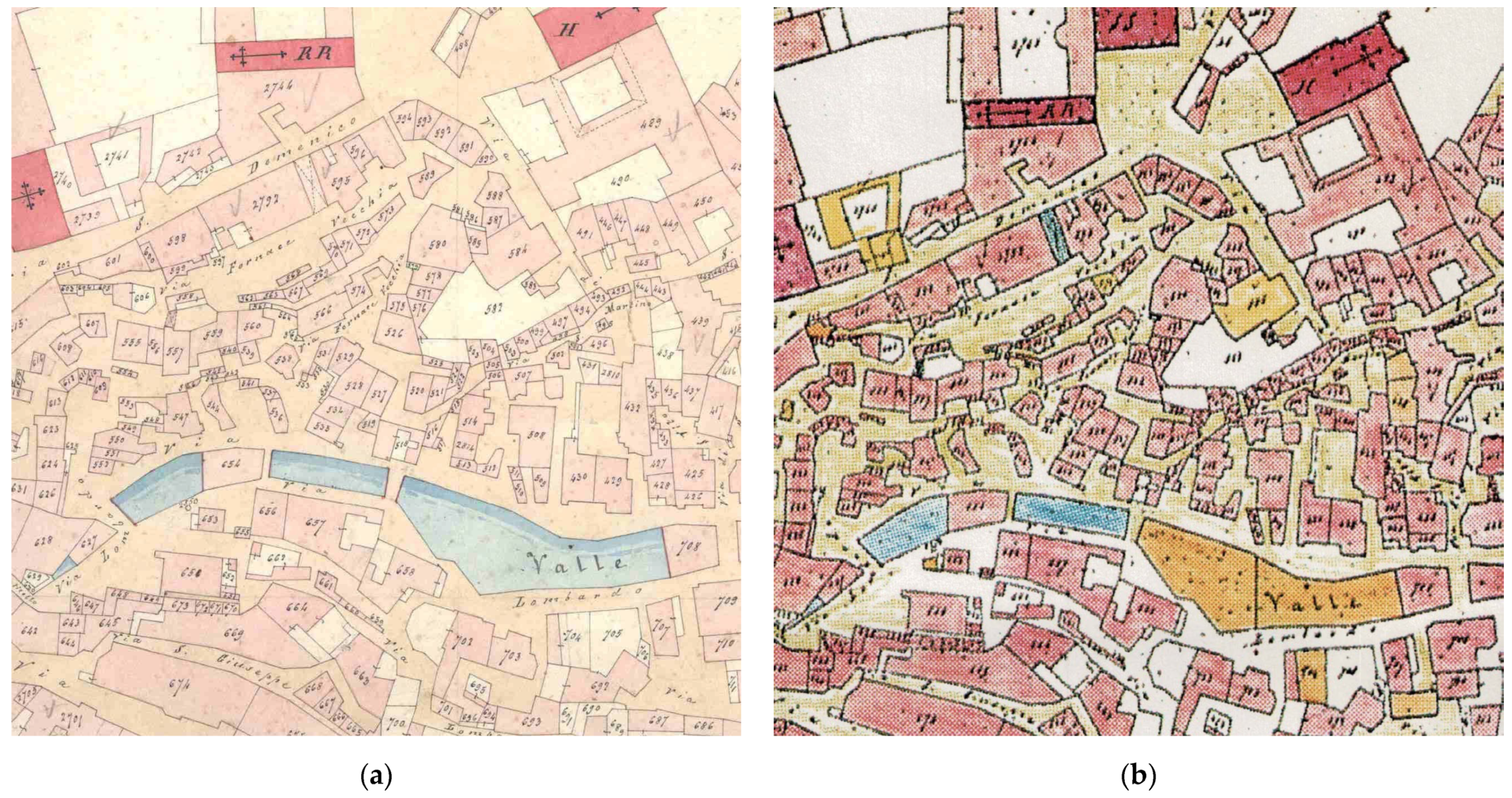
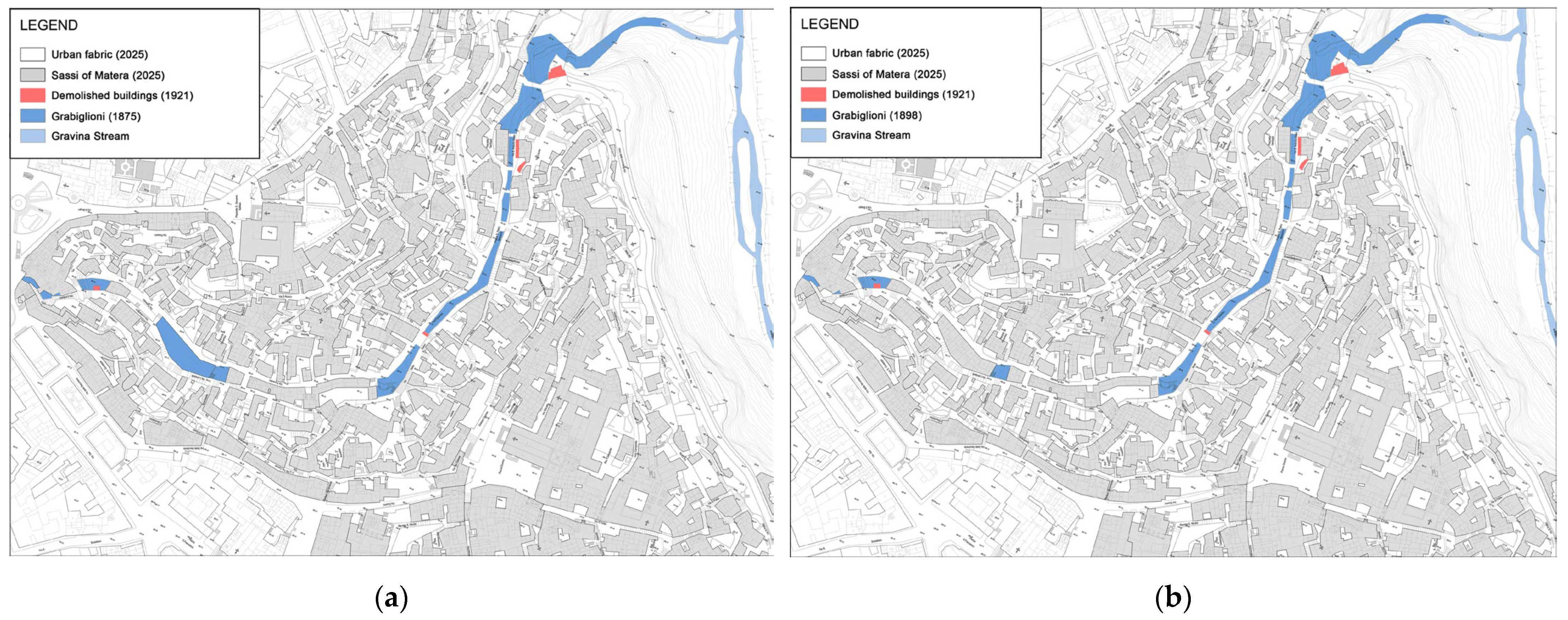
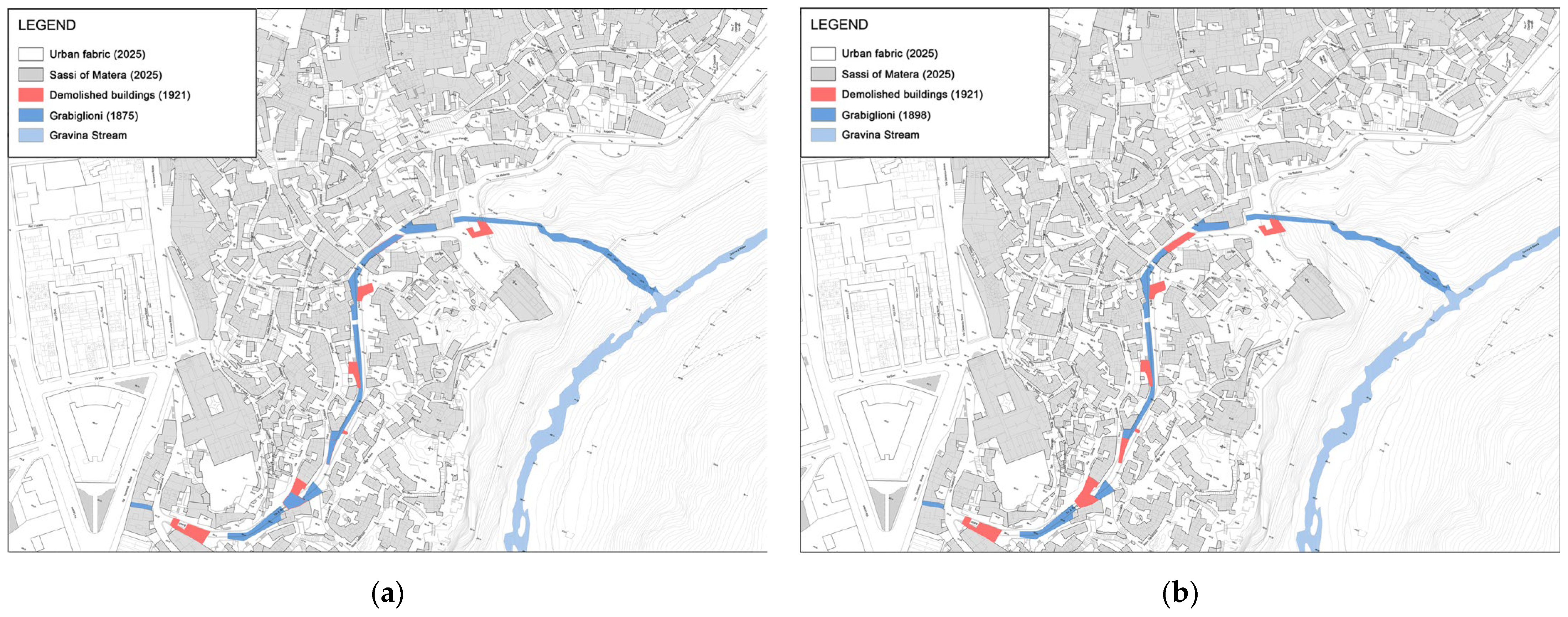
11].The study and digital reconstruction of the cadastral maps from 1875 (
Figure 4a) and 1898 (
Figure 4b) revealed that the two
Fossi, still visible as streams at the time, were delineated by embankments bordered by pedestrian paths, small structures built on them, and small bridges crossing them.
In this urban landscape, the western clayey hills of
Macamarda,
Serra Venerdì,
Cimitero,
Lapillo(or ofthe
Castle), and
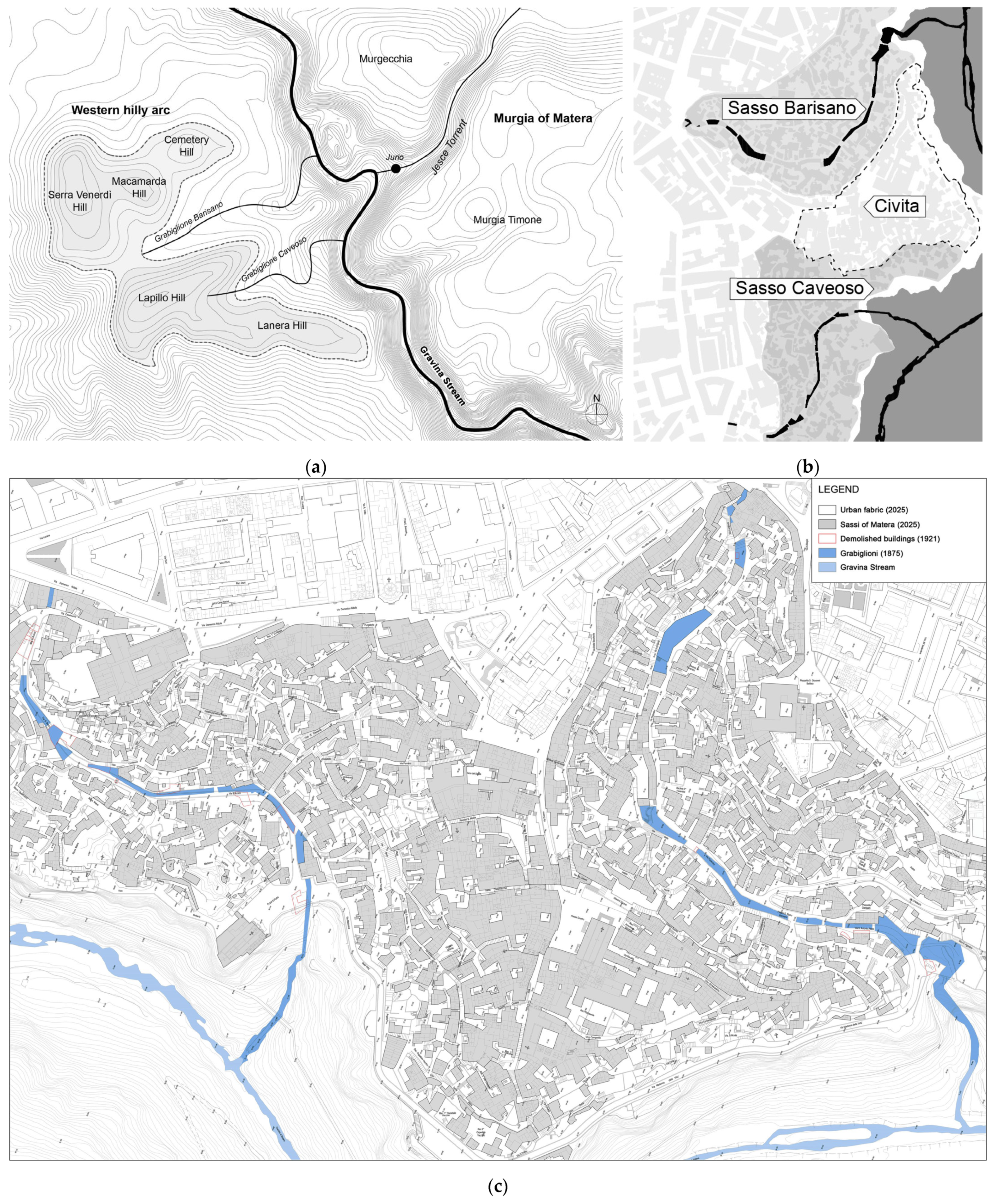
Lanera intercepted large quantities of water, channeling it toward the two
Grabiglioni (
Figure 5a). The watercourse etched into the rock reflected the city’s unique morphology: a central spur that hosted the medieval
Civita, and two rocky valleys that contained the urban districts of
Sasso Barisano and
Sasso Caveoso, positioned along the two streams (
Figure 5b,c) [
1,
3,
4,
5,
6,
7,
8,
10,
11].
The
Grabiglione Barisano, also known as the
Fosso Barisano, extended over 560 m, starting from an elevation of 385 m above sea level at the present-day
Vittorio Veneto Square. It descended to a height of 348 m above sea level at the current
Madonna delleVirtù Street, with a gradient of 4% (
Figure 6a,b) [
1,
13,
14].
Meanwhile, the
Grabiglione Caveoso extended for 420 m, starting at an elevation of 383 m above sea level near the current
Domenico Ridola Street, and descending to
San Pietro Caveoso Square at an altitude of 346 m above sea level, with a gradient of 6% (
Figure 7a,b) [
1,
13,
14].
The crossing of the
Grabiglioni was facilitated by small bridges constructed with squared blocks of calcareous stone, as evidenced by examples such as the bridge near the Chapel of
Sant’Antonio Abate, which connected the present-day
Fiorentini Street with
San Pietro Barisano Square; the so-called
Di Noia bridge, which linked
Madonna delleVirtù Street,
Sant’Antonio Abate Street,
Sant’Agostino Street and the three small bridges located at the current
Lombardi Street [
14].
It is only with the technical documents from the early decades of the 20th century that a radical shift becomes evident: the streams were buried, covered by vehicular roads, and within them, sewage collectors were installed, thus interrupting and blocking the original water system. Above the two
Grabiglioni,
Fiorentini Street and
Bruno Buozzi Street were constructed, which were the key roads providing access to the
Sassi [
1,
13,
14].
The construction works for the sewage collector of
Sasso Barisano and
Fiorentini Street were completed in 1935, involving the demolition of entire buildings and small structures. In the terminal section of
Fiorentini Street an underground sewage and stormwater pumping system was installed (
Figure 8) [
1,
13,
14].
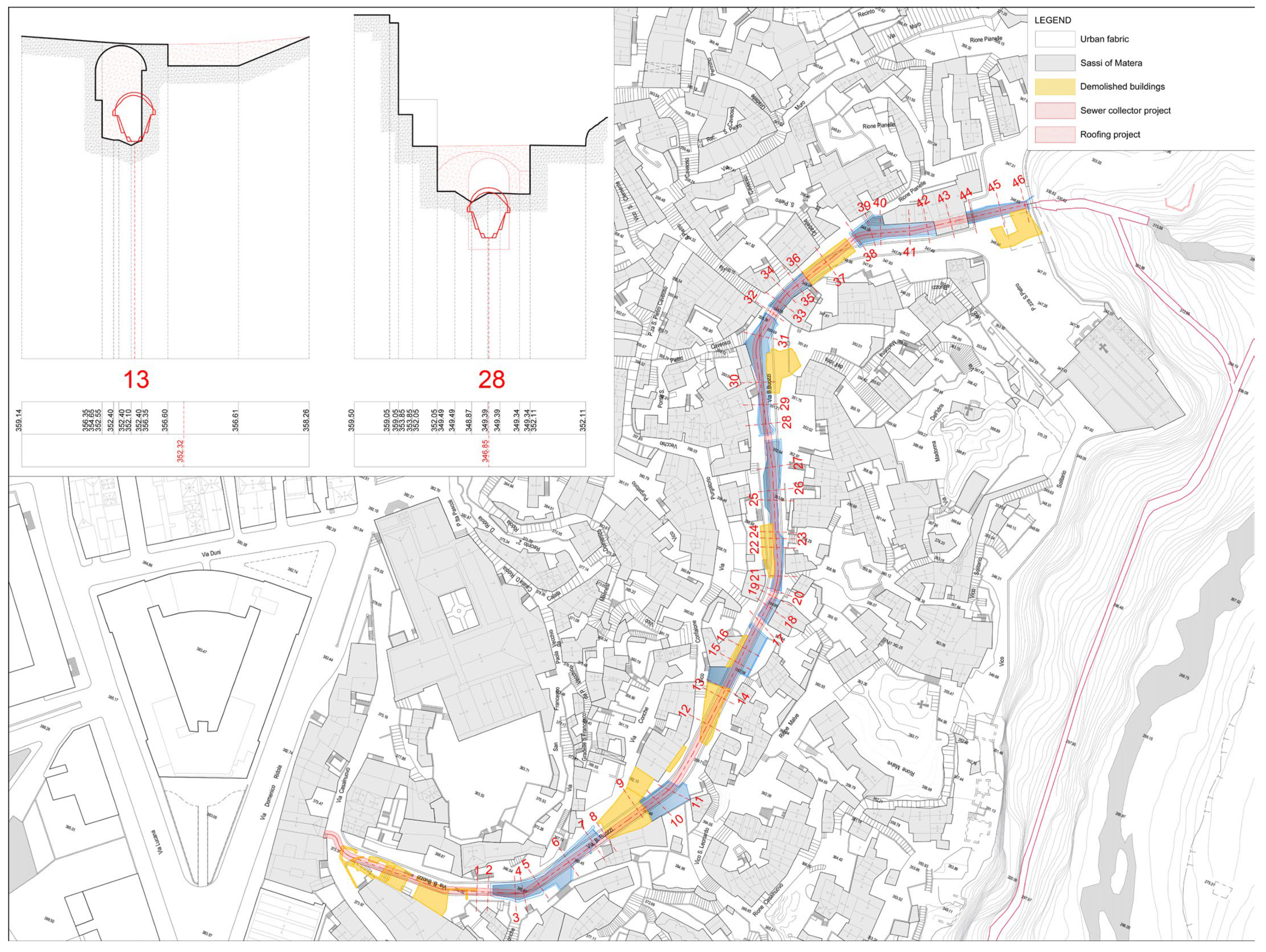
Regarding the construction of the sewage collector and its covering system along the
Grabiglione Caveoso in 1921, it required the demolition of “cave-houses” and buildings. Specifically, the areas to be demolished for the execution of the works totaled 80 rooms, distributed as follows: fifteen single-room houses with underground stables or haylofts, four two-story houses, one two-room house with a kitchen, two three-room houses, and finally, twenty inhabited cellars with stables, haylofts, pigsties, and other production spaces (
Figure 9) [
1,
13,
14].
The roofing of the Grabiglioni and the construction of the sewage collectors marked a significant infrastructural “turning point” for the city of Matera, aligned with the urban modernization trends of the time. These operations, primarily aimed at sanitizing the town center and separating domestic and stormwater flows, led to the burial of the streams and their transformation into underground sewers. The original design of these systems reflected an urban and hydrological layout that was profoundly different from the current one: the areas uphill from the historic urban fabric of the Sassi were exclusively agricultural lands and uncultivated green spaces. The sewer collectors channeledthe excess water, no longer absorbable by the extensive permeable surfaces, towards the Gravina Stream. In this manner, the proper regulation of stormwater was effectively ensured.
The ecological balance was irreversibly altered with the twentieth-century urban expansion, which had a significant impact on the entire “urban metabolism” [
2] of the city, and more specifically, on the functionality of the aforementioned sewage collectors.
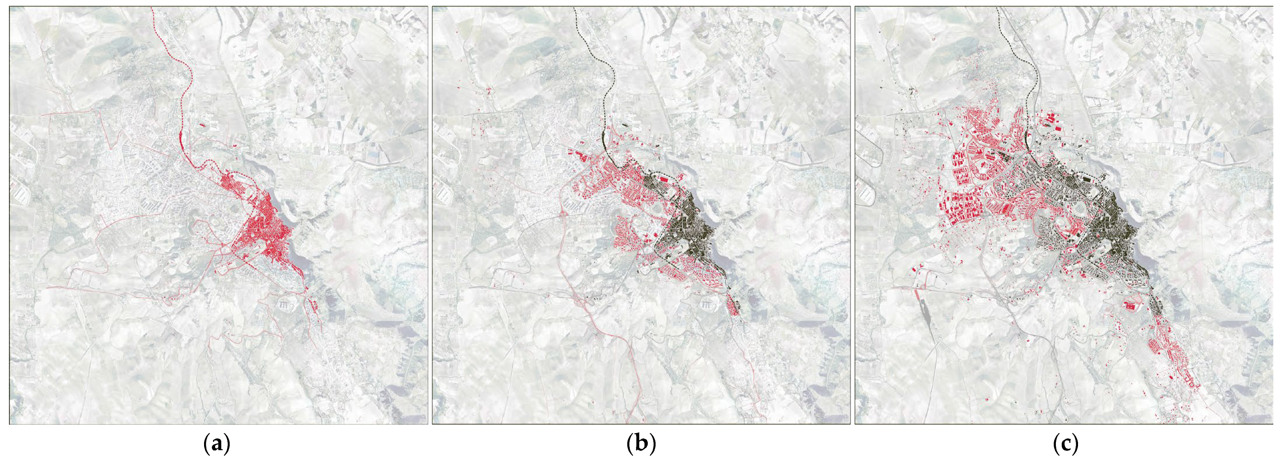
The 1935 expansion plan, aimed at improving the sanitary conditions of the
Sassi through the creation of vehicular roads, sewers, and potable water distribution systems, represented the first territorial transformation (
Figure 10a) [
1].
However, it was the General Regulatory Plan (PRG) of 1956, drafted by
Luigi Piccinato, that marked the most radical historical break: the abandonment of the
Sassi and the construction, starting in 1952 through the “
Colombo Law” (Law No. 619/1952), of modern urban districts such as
Serra Venerdì,
La Martella,
Spine Bianche,
Lanera, and
San Giacomo. These urban districts were designed based on organic architecture models, collective green spaces, and neighborhood units [
1]. In these new areas, there was an attempt to transfer the community-oriented character typical of the
Sassi neighborhoods, with a focus on the relationship between private housing and common goods (
Figure 10b).
However, the PRG amendment of 1973 (
Figure 10c) extended urban expansion well beyond the initial demographic projections, giving rise to massive real estate speculation, the cementing of green areas such as the
Macamarda hill, and the intensification of residential density. This led to a progressive loss of the environmental and community qualities initially sought, pushing the city towards its contemporary configuration [
1] (
Figure 10c).
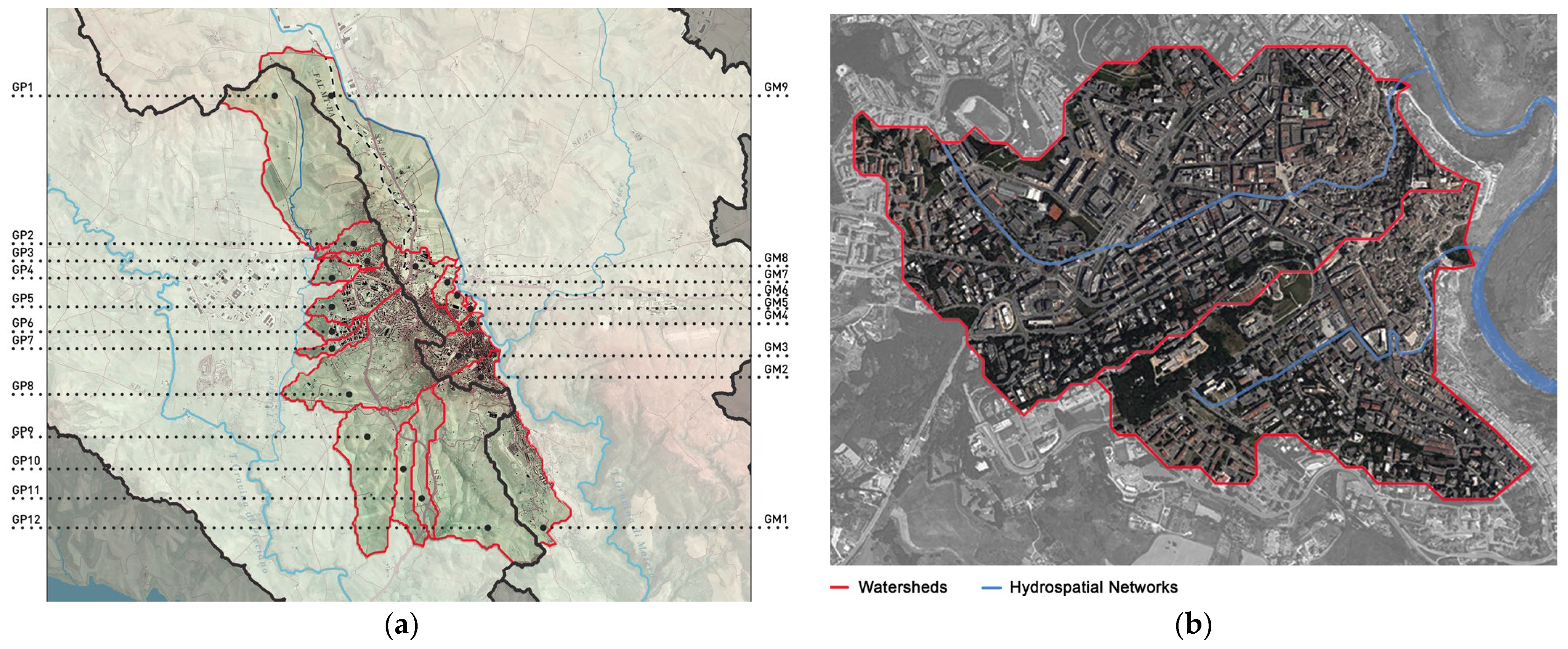
The hydromorphic inspection identified 12 independent urban watersheds (
Figure 11a), using the Digital Terrain Model (DTM) provided by the RSDI Basilicata portal [
15], with processing conducted via QGIS 3.4.13 and GRASS GIS 7.2.0 software.
Through this process, it became evident that, although the
Sassi now appears as a single urban fabric, it actually consists of two independent hydromorphic units. This integrated reading led to the delimitation of two distinct hydrographic watersheds (
Figure 11b): GM2 (
Sasso Caveoso) and GM3 (
Sasso Barisano), which encompass the historical urban fabrics as well as the uphill expansion areas.
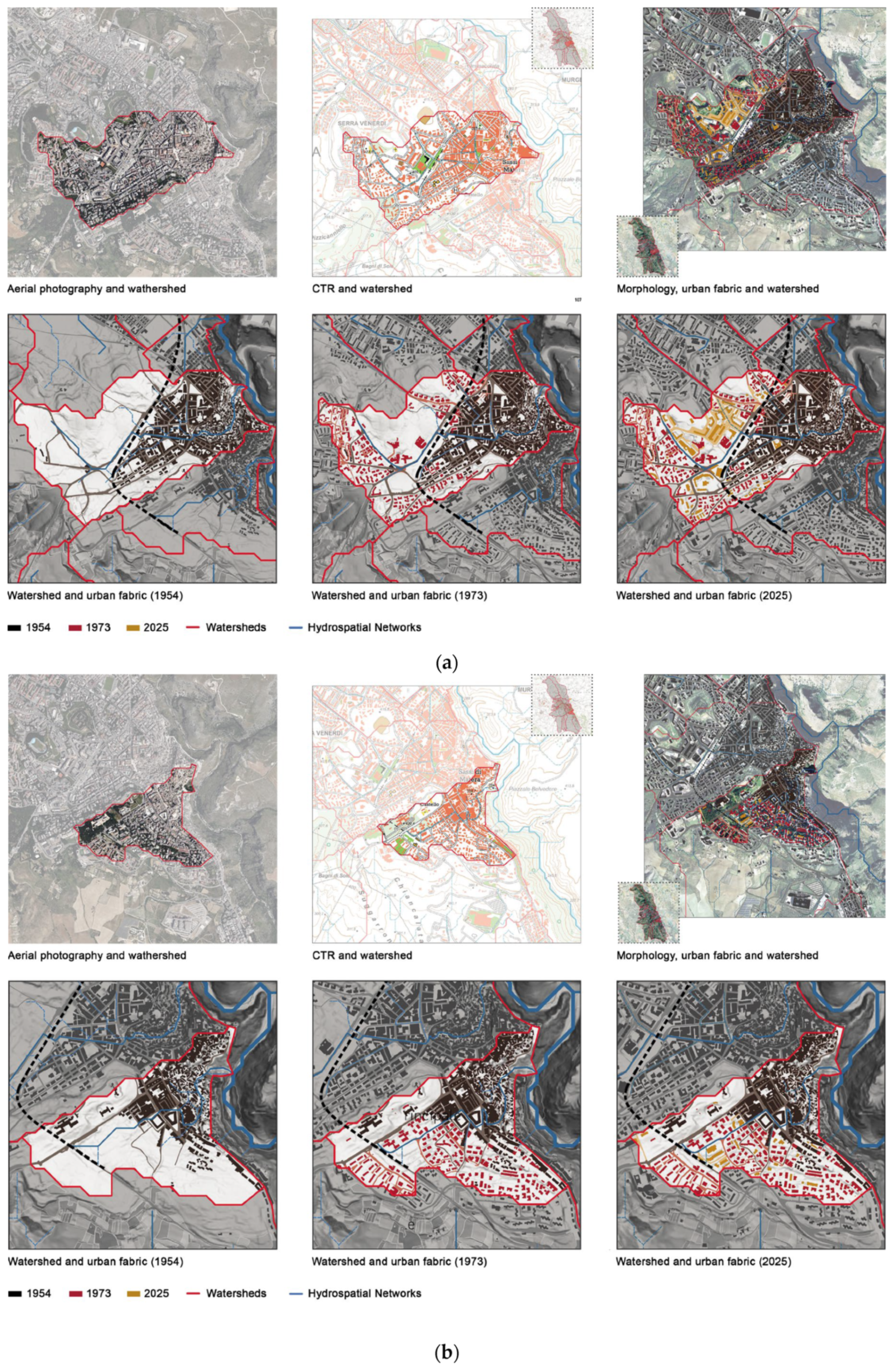
The GM3 watershed encompasses an area of 1.21 km
2, including the territory extending from
Macamarda and
Lapillo hills to
Madonna delleVirtù Street. Here, the mainstream follows Via Fiorentini, with an average gradient of 7% (
Figure 12a). In contrast, the GM2 watershed covers approximately 0.66 km
2 and stretches from Castello Street to San Pietro Caveoso Stream, with its main channel coinciding with Bruno Buozzi Street, exhibiting an average gradient of 12% (
Figure 12b).
Urban expansion since the 1950s has led to a significant increase in impermeable surfaces: in GM3, the percentage has risen from 35% in 1954 to 55% in 1973, and currently stands at 70% (
Figure 12a); whereas in GM2, it increased from 30% in 1954 to 55% in 1973, reaching 65% today (
Figure 12b).
3. Results
The multidisciplinary analysis conducted on the Grabiglioni has provided a detailed picture of the evolution of historical water infrastructures and their strategic role in the urban transformations, highlighting key changes in both the urban morphology and water management practices.
The archival research and digitization of historical technical drawings enabled a precise reconstruction of the original morphology of this heritage, which functioned as open streams for the regulation of both stormwater and wastewater. The Grabiglione Barisano and Grabiglione Caveoso were naturally carved ravines in the rock, with marked slopes (4% and 6%, respectively) and banks integrated into the urban fabric via bridges and pedestrian pathways. These ensured the efficient drainage of water from the surrounding hills (Macamarda, Serra Venerdì, Lanera, Cimitero) toward the Gravina Stream, maintaining hydrological balance and preventing flooding in the historical city center.
The findings reveal that, starting in the early decades of the 20th century, the process of urban modernization led to a profound transformation of the Grabiglioni and their urban context. The roofing of these ravines and the simultaneous construction of two sewage collectors, one for each stream, marked the definitive disruption of the historic hydraulic system. These interventions, documented in technical projects from the 1920s and 1930s, involved not only the burial of the streams but also the demolition of numerous buildings. The roadways created in this process gave rise to a new urban morphology that concealed the original configuration of the Sassi.
The urban expansion that began in the 1950s led to a growing impermeabilization of surfaces, altering the hydrological balance and undermining the functionality of the collectors, which had been designed to work with a hydrological system based on extensive permeable surfaces and agricultural land use in the upstream areas.
Hydromorphic analysis has shown that Fiorentini Street and Bruno Buozzi Street, located respectively above the Grabiglione Barisano and Grabiglione Caveoso, serve as the primary lines of drainage for their corresponding watersheds. This morphological setup leads to intense surface runoff along the two roadways, creating critical issues both for the streets themselves and for the urban spaces connected to them. In particular, the final stretch of Fiorentini Street and San Pietro Caveoso Square isfrequently subject to flooding, posing a danger to tourist flows, residents, commercial activities, and the historic built heritage.
The increased stormwater runoff, now channeled into a system designed for different hydrological conditions, has resulted in an overload of the sewage system, causing backflow and hydraulic problems near the historic areas.
The increasingly frequent floods affecting the current historic center of Matera, such as those on and 2 June 2023, are direct consequences of these profound transformations [
16,
17].
The case of Matera fully exemplifies the functional misalignment between historic infrastructures and contemporary hydrological dynamics, a phenomenon frequently highlighted in scientific literature as one of the main vulnerabilities of European historic centers. As a result, the sewage system is often subjected to stress beyond its operational capacity, leading to localized impacts on hydraulic safety, the preservation of historic built heritage, and the quality of surface and groundwater.
From a historical and cultural perspective, the research has highlighted the Grabiglioni as infrastructures of significant documentary and identity value, testifying to a body of technical knowledge and sustainable environmental management developed over centuries. These infrastructures represent a “hidden” urban heritage with great potential for educational, narrative, and tourism-related initiatives. Acknowledging the original architectural and engineering value of the Grabiglioni, along with the transformations they have undergone, lays the groundwork for a broader reflection on the potential to reintegrate these infrastructures into urban regeneration processes and integrated planning strategies. In summary, the findings demonstrate how the historical water infrastructures of the Grabiglioni serve as essential interpretative keys to the urban transformations of Matera, capable of connecting historical, environmental, and design dimensions in an interdisciplinary and prospective framework.
4. Urban Planning Perspectives
A detailed survey of the Grabiglioni sewer collectors is essential to acquire significantly improved quantitative and qualitative data regarding their current state, extent, and functional capacity. While the reconstruction of the Grabiglioni’s geometries through archival historical documentation has proven invaluable, direct survey of their present condition remains indispensable. The surveying process will be conducted utilizing innovative and non-invasive technologies capable of detecting and mapping underground spaces without the need for direct physical access by operators. The data acquired through the direct surveyforms the necessary basis for any informed intervention strategy, enabling a clearer understanding of the infrastructure’s spatial configuration, material conditions, and potential for reintegration within contemporary urban water management systems.
Among these, notable examples include Ground Penetrating Radar (GPR) and Electrical Resistivity Tomography (ERT). The comprehensive knowledge base developed through this process can, in turn, contribute meaningfully to participation in national and European funding programs (PNRR, Horizon Europe, Interreg, FSC, POR) and foster the development of partnerships with universities, research institutions, and innovative companies active in environmental monitoring and the recovery of underground heritage.
To this end, in light of the challenges posed by climate change and the increasing impermeabilization of urban soils, the issue of stormwater regulation within historic urban centers today assumes strategic significance, both in terms of hydraulic safety and environmental sustainability [
18,
19,
20]. In consolidated urban contexts, and particularly within historic cores characterized by dense built fabrics and outdated infrastructures, the inadequacy of sewerage systems to manage intense rainfall events often results in uncontrolled surface runoff, thereby exacerbating hydrogeological risk and inflicting damage upon the built heritage. Within this scenario, the recovery and functional adaptation of ancient water infrastructures (such as cisterns, subterranean channels, and distributed collection systems) emerges as a highly relevant and forward-thinking design approach. Originally conceived over centuries to address conditions of water scarcity, these systems now prove to be effective tools not only for supplementing existing water supply sources, but also for regulating urban water flows, thereby contributing to flood risk mitigation [
19]. By way of illustration, the case study of traditional cisterns in Western Mani [
21] demonstrates how the intelligent reuse of historical rainwater harvesting techniques, supported by advanced hydrological modeling, can yield resilient and low-impact solutions for managing stormwater volumes. When integrated into a broader framework of Sustainable Urban Drainage Systems (SUDS), such infrastructures can help to slow down, retain, and reuse rainwater in situ, thereby alleviating the burden on sewer networks and fostering a more harmonious balance between the urban environment and the natural water cycle.
More specifically, the historical sewer collectors of the Grabiglioni, currently serving as conduits for both wastewater and surface stormwater runoff, could be complemented by an additional, purpose-designed infrastructure capable of ensuring the effective drainage and treatment of urban water flows. Such an integrated system would mitigate the occurrence of critical events, such as flooding and uncontrolled surface runoff, thereby significantly enhancing the hydraulic resilience of the historic urban fabric.
In addition to the Grabiglioni, the recovery and functional reintegration of other presently occluded hydraulic infrastructures, such as the large public cisterns and the extensive network of private water tanks dispersed throughout the historic core, could further augment the system’s overall capacity to manage surplus water volumes. When strategically reactivated and interconnected, these cisterns can operate as decentralized retention basins, temporarily storing excess runoff and gradually reintroducing it into the urban drainage cycle.
5. Discussions
Historical infrastructures represent a fundamental category of cultural heritage, as they encompass both tangible and intangible values, local identities, and adaptive strategies developed in response to specific environmental contexts. These strategies are based on the sustainable use of natural resources, which are essential for human survival.
In recent decades, historic infrastructures have garnered renewed interest in academic and institutional circles, being recognized as cultural heritage not only for their intrinsic vulnerability but also for the emergence of new paradigms in cultural conservation and urban sustainability. They are increasingly recognized for their ability to address many contemporary urban challenges, such as land scarcity, environmental resilience, and the protection of cultural identity.
However, this heritage remains insufficiently considered within institutional regulatory and planning frameworks, and many infrastructures are often hidden beneath modern urban fabrics or are inaccessible.
A comprehensive study of the historic water infrastructures of the Grabiglioni in Matera stands as a strategic and cross-sectoral resource for the Municipality Administration, with significant implications for urban safety, cultural enhancement, sustainable planning, access to funding, and tourism promotion. In this regard, the Grabiglioni can be viewed as elements of historical environmental infrastructure, resulting from a skilled interaction between hygienic-sanitary needs, natural resource management, and adaptation to the geomorphological context.
Their architectural analysis not only reveals the technical complexity of a vital yet invisible work, but also opens up reflections on their potential reinterpretation in contemporary terms as devices for urban sustainability, hydraulic risk mitigation, and the cultural enhancement of Underground Built Heritage (UBH) [
20].
From a safety and hydrogeological risk prevention perspective, a detailed understanding of this heritage allows for the precise mapping of stormwater runoff paths, identifying critical points more prone to flooding, subsidence, or structural degradation. Urban arteries of primary importance, such as Fiorentini Street and Bruno Buozzi Street, currently the main access routes for both vehicular and pedestrian traffic to the Sassi urban districts, are frequently subject to uncontrolled surface runoff and overflow events. However, the lack of updated knowledge regarding the state of preservation of the underlying infrastructures represents a potential risk factor to public safety in an area daily traversed by thousands of residents and visitors.
6. Conclusions
Culturally, the Grabiglioni constitutes a foundational element of Matera’s UBH, offering tangible evidence of a sophisticated historical system for managing water resources. Their rediscovery and valorization would strengthen the city’s identity narrative, enriching the UNESCO-recognized heritage and giving visibility to a vital infrastructure, currently hidden from most visitors and even local residents.
Integrating the Grabiglioni into urban planning also represents a concrete opportunity for adopting a multi-level approach to territorial governance. Including knowledge of the underground infrastructure in key planning tools, such as the PUC (Municipal Urban Plan) and the PUMS (Sustainable Urban Mobility Plan), enables more effective and sustainable urban space management, preventing conflicts with incompatible construction or infrastructural projects and promoting resilient solutions aligned with European objectives on climate adaptation and urban regeneration.
This distributed and multifunctional water infrastructure network would not only optimize stormwater regulation within the dense historic center but also serve as a preventative mechanism against the emergence of critical flood conditions, safeguarding both urban safety and cultural heritage.
Lastly, the rediscovery of the Grabiglioni could serve as a powerful driver for diversifying the tourism offer, by creating thematic itineraries focused on the culture of water, historical engineering, and urban archeology. Integrating these elements into local cultural and tourism circuits would contribute to the de-seasonalization of tourist flows, a more balanced distribution of visitors, and the promotion of a more conscious and sustainable experience of the Sassi.
The study of the Grabiglioni is not merely an initiative for the preservation of the past but a strategic investment in the city’s future. It synergistically addresses objectives of urban safety, climate resilience, cultural enhancement, and economic development, positioning itself as a fundamental asset for the public policies of the Municipality of Matera.
The workflow developed for the case study of Matera offers a replicable model for other urban contexts with historical infrastructures, providing methodological insights useful for defining interdisciplinary practices involving historians, engineers, urban planners, and public administration technicians.
