Article

Aeolian Landscapes and Paleoclimatic Legacy in the Southern Chacopampean Plain, Argentina

1
CEIDE (Centro de Estudios Integrales de la Dinámica Exógena), Universidad Nacional de La Plata (UNLP), La Plata 1900, Argentina
2
CIC (Comisión de Investigaciones Científicas), La Plata 1900, Argentina
3
Department of Geosciences, University of Malta, MSD 2080 Msida, Malta
4
CONICET (Consejo Nacional de Investigaciones Científicas y Técnicas), Godoy Cruz 2290, Argentina
*
Author to whom correspondence should be addressed.
Geographies 2025, 5(3), 33; https://doi.org/10.3390/geographies5030033
Submission received: 25 April 2025 / Revised: 28 June 2025 / Accepted: 1 July 2025 / Published: 14 July 2025

Abstract

The Chacopampean Plain is a major physiographic unit in Argentina, bounded by the Colorado River to the south, the Sierras Pampeanas and Subandinas to the west, and the Paraná River, Río de la Plata Estuary, and the Argentine Sea to the east. Its subsurface preserves sediments from the Miocene marine transgression, while the surface hosts some of the country’s most productive soils. Two main geomorphological domains are recognized: fluvial systems dominated by alluvial megafans in the north, and aeolian systems characterized by loess accumulation and wind erosion in the south. The southern sector exhibits diverse landforms such as deflation basins, ridges, dune corridors, lunettes, and mantiform loess deposits. Despite their regional extent, the origin and chronology of many aeolian features remain poorly constrained, as previous studies have primarily focused on depositional units rather than wind-sculpted erosional features. This study integrates remote sensing data, field observations, and a synthesis of published chronometric and sedimentological information to characterize these aeolian landforms and elucidate their genesis. Our findings confirm wind as the dominant morphogenetic agent during Late Quaternary glacial stadials. These aeolian morphologies significantly influence the region’s hydrology, as many permanent and ephemeral water bodies occupy deflation basins or intermediate low-lying sectors prone to flooding under modern climatic conditions, which are considerably wetter than during their original formation.

1. Introduction

The Chacopampean plain (Chacobonaerense [1] occupies a large part of the Argentine surface. It has a wide smooth topography limited to the south by the Colorado River, to the west by the Sierras Pampeanas and Subandinas, and to the east by the Paraná River. Sediments of the Miocene marine ingression are preserved in the subsurface. The stratigraphic and geomorphologic units that prevail in the north of this landscape are mainly related to fluvial processes [2], and those of the southern sector, to eolian processes (Figure 1). The deposits and geomorphologic features were developed in a wide variety of environments, influenced by local climatic characteristics and topography. However, most of them would have been formed under arid climatic conditions not only during the late Cenozoic glacial periods but also during warm climatic interstadials [3].
These past climatic fluctuations have been well known worldwide since the past century [6]. At a local level, they are known through the record of the glaciations of the Patagonian mountain range e.g., refs [7,8,9,10,11], by sea level changes e.g., refs [12,13,14,15,16], and by the accumulation of significant sand and loess sheets e.g., refs [5,17,18,19,20].
Much of the southern part of the Chacopampean plain has excellent exposures of landforms produced by eolian action. These are represented not only by outstanding deposits several tens of meters high but also by notable erosive features, up to 100 m deep. These erosive features reveal that wind has been one of the main modeling agents of the regional landscape, the Miocene sedimentary rocks of La Pampa province and central–west of Buenos Aires province [21] being the oldest ones affected by eolian processes.
Sand and loess deposits are directly related to global climatic changes, except those related to the Atlantic coast. The present warm–humid conditions provide a strong stability to the eolian deposits through vegetation cover and soil development, but those of peripheral areas (on the border of the warm–humid climate) undergo local remobilizations during water deficit, often caused by agricultural–livestock activities [22]. Recent geophysical studies in the region have highlighted the stratigraphic complexity and sensitivity of these Quaternary deposits to climatic and hydrological changes [23] Their wide distribution and exposure, including paleosoils and fossil remains, supply information about Quaternary paleoclimatic and paleoenvironmental conditions. Simultaneously, wind has produced different erosive features that also provide interesting information for the reconstruction of the local geological history, and has been the main source of the eolian deposits located in the surroundings or more distally. Some of these landforms may be deflation basins or playas [24], deflation holes, and corridors or furrows associated with yardangs [25], which may be active or inactive according to the present climatic condition.
The main goal of this contribution is to present different types of information about the main eolian landforms characterizing the landscape of the southern Chacopampean plain, their chronology, and their paleoclimatic and/or paleoenvironmental meaning. Special emphasis is placed on assessing the geomorphological expression of late Quaternary climatic fluctuations, as recorded by the formation and reworking of aeolian landforms across the southern Chacopampean Plain.

2. Materials and Methods

2.1. Study Area and Regional Geology

The study area is located in the southernmost sector of the Chacoparanense Plain, covering the central and northern Buenos Aires Province, as well as western La Pampa Province in central–eastern Argentina, between approximately 35–38 °S and 57–66 °W (Figure 1). The region encompasses structural units including Tandilia and Ventania ranges, as well as the Macachín, Claromecó, and Salado basins. Major geomorphological units include the transverse valleys of northeastern La Pampa Province [26] and the Pampean Sand Sea (Mar de Arena Pampean [27]), covering the Sandy Pampa (partially occupying Buenos Aires, La Pampa, Córdoba, and Santa Fe provinces) and the peripheral loess belt (Buenos Aires and Santa Fe provinces). Other important geomorphological domains in the study region include the Tandilia and Ventania mountain ranges, the Interserrana Plain (Llanura Interserrana; [28]), the Coastal Plain (Llanura Costera), and the Depressed and Undulating Pampas (Pampa Deprimida and Pampa Ondulada; [29]).
Most of the study region drains toward the Río de la Plata estuary (Depressed and Undulating Pampas), toward the Atlantic Ocean (Interserrana Plain), and includes significant internal drainage areas (arheic conditions) in the Sandy Pampa and endorheic conditions within the corridor regions.
The current climate of the study area ranges from humid–temperate (Cf) in the east to semi-arid (Bs) in the west, with this climatic boundary periodically shifting throughout the geological record, directly influencing regional geomorphological processes [30]. This climatic boundary is particularly relevant to the present study, as historical fluctuations between humid–temperate and semi-arid conditions have been shown to control aeolian activity, sediment availability, and landscape stability throughout the late Quaternary [30].
The geological context outlined here provides essential background for interpreting the aeolian units described in this study, as variations in lithology, sedimentary characteristics, and substrate stability directly influence the spatial distribution, morphology, and preservation of aeolian landforms.
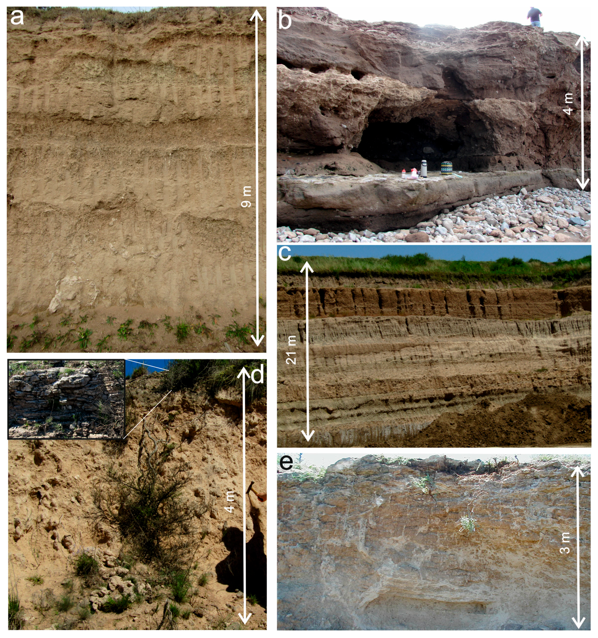
The geological substrate of Buenos Aires Province, upon which the main aeolian features developed, belongs primarily to the Pampeano Formation [31] and the Cerro Azul Formation [32], the latter extending along the western margin of Buenos Aires Province and eastern La Pampa Province (Figure 2).
The Pampeano Formation comprises loess deposits also known as Pampean Sediments (Sedimentos Pampeanos; [33]), or as the Ensenada and Buenos Aires Formations [34]. Due to its thickness and widespread distribution, it represents the characteristic lithological unit of the Pampean Plain in many areas covered by younger sediments or serving as parent material for modern soils. Although deposited under generally arid to semi-arid conditions, the stratigraphic record includes paleosols—some with hydromorphic features—and fluvial, alluvial, lacustrine, and littoral deposits, indicative of warmer and more humid episodes e.g., refs [5,17,35,36]. Texture varies considerably from silty sands to clayey silts, dominated locally by very fine sands or coarse silts [5,37,38,39].
The Cerro Azul Formation, extensive toward the southwest, correlates with deposits of the Epecuén Formation [40], cropping out as far as southeastern Mendoza Province [41,42]. This unit has been referred to historically under different names, including the Araucana Formation [43], Pampeano Formation [44,45], Epecuén Formation [46,47], and La Pampa Formation [48]. The Cerro Azul Formation mainly consists of very fine silty sandstones and sandy siltstones, with basal intercalations of claystone. It is generally light brown to pale reddish-brown, capped by calcrete precipitates or “tosca”, sometimes including volcanic clasts forming micritic shale beds with planar or subhorizontal bedding and pisolitic horizons [21,41]. The unit reaches a maximum thickness of approximately 180 m [49]. The marked lithological homogeneity and friable nature of these sediments result in abrupt erosional scarps and cliffs due to their uniform, fine-grained character. These deposits formed in a plains environment characterized by loess deposition, punctuated by the development of weakly expressed paleosols.
The Cenozoic sedimentary sequences of the southern Pampas have been chronologically constrained, primarily through paleontological and paleomagnetic studies, with limited numerical dating providing calibration points for biostratigraphic and magnetostratigraphic frameworks. Sequences from northeastern Buenos Aires Province yield numerical ages around 200 Ka [50,51] and 390 Ka [52]. Paleomagnetic investigations indicate minimum ages close to 1 and 1.8 Ma for the oldest exposures [38,53,54,55]. In southeastern Buenos Aires Province, impact glass (escorias) from the Chapadmalal Formation dates at approximately 3.3 Ma [56], while paleomagnetic studies suggest deposition during the late Pliocene (Gauss Chron, 3.6–2.6 Ma; and late Gilbert Chron, 4–3.6 Ma; [57,58,59,60]). Toward the southwest, in the Ventania ranges, ages extend back to the late Miocene, based on escorias dated at 9.23 ± 0.09 Ma from the Arroyo Chasicó Formation [61], and supported by regional stratigraphic studies from the La Pampa ([21] and references therein), Bahía Blanca [62], and Tandil ranges [63].

2.2. Methodology

The spatial distribution, morphology, and temporal evolution of aeolian landforms in the southern Chacopampean Plain were analyzed through an integrative approach combining remote sensing analysis, geomorphological interpretation, and synthesis of previously published sedimentological and chronometric data.

2.2.1. Remote Sensing and Geomorphological Mapping

The geomorphological characterization of aeolian landforms was conducted through detailed analysis of multi-source satellite imagery and digital elevation models (DEMs). Optical datasets from Landsat 7 and 8, SPOT 5–7, and Sentinel-2 were employed due to their complementary spatial, spectral, and temporal resolutions. Sentinel-1 Synthetic Aperture Radar (SAR) imagery provided additional insights, particularly useful in areas with dense vegetation or limited optical visibility.
High-resolution imagery accessible through Google Earth Pro was extensively used for visual verification of geomorphic features and for assessing temporal dynamics. DEMs were primarily derived from NASA’s Shuttle Radar Topography Mission (SRTM), with a spatial resolution of 30 m (1 arc-second), obtained via the Global Land Cover Facility (GLCF), University of Maryland. These elevation datasets facilitated the generation of topographic visualizations, including hillshade maps, slope analyses, and elevation profiles, which were critical for morphological interpretations and the delineation of aeolian units.
All remote sensing datasets were processed and integrated using QGIS (v3.34), ENVI (V5.6), SNAP (V10.0), and Global Mapper (V24.1) software platforms. Field visits supported this approach by confirming key geomorphological features previously identified through imagery analysis and by verifying landscape conditions in specific localities.

2.2.2. Chronometric and Sedimentological Framework

Given the extensive regional scale of the study area, this work strategically integrates previously published chronometric and sedimentological data rather than generating new laboratory analyses. Existing Optically Stimulated Luminescence (OSL) and radiocarbon (14C) ages were compiled from earlier stratigraphic and paleoenvironmental studies conducted in adjacent fluvio-lacustrine and coastal contexts e.g., refs [3,64,65]. Although these ages were not directly derived from the aeolian landforms analyzed here, their geographical proximity, stratigraphic relevance, and paleoenvironmental coherence provide robust temporal constraints that significantly enhance the interpretation of aeolian dynamics and climatic influences.
Sedimentological and stratigraphic data from previous publications e.g., refs [3,5,37,52,66,67] were also systematically reviewed to contextualize the regional sedimentary record within a coherent geomorphological framework. These studies provided detailed descriptions of sediment textures, stratigraphic relationships, and paleoenvironmental interpretations crucial to understanding landscape evolution.
The originality of the present contribution resides in the integrative reinterpretation of these chronometric and sedimentological datasets through a specifically geomorphological lens. By synthesizing these existing data sources within a unified regional framework, this study elucidates the spatial and temporal patterns of aeolian processes and their paleoclimatic significance in the southern Chacopampean Plain, offering a novel perspective on landscape evolution.

3. Results: Geomorphological Environments

Both erosion and eolian accumulation processes have acted upon the substrate in the study area, resulting in a variety of landscape features that are grouped into different geomorphological units (Figure 3). These units are primarily determined by wind action, influenced not only by present and past climatic conditions but also by specific characteristics of the substrate, vegetation, and the position of the water table. The units include corridors, crests, and deflation basins; longitudinal dunes; parabolic dunes; playas and lunettes; mantiform loess; and mantiform loess with transverse silt dunes.
The following sections provide a detailed description of each geomorphological unit, highlighting their morphological characteristics, spatial distribution, and the factors influencing their formation under specific paleoclimatic conditions. The geomorphological domains of the Coastal Plain and the Pampa Interserrana, however, are excluded from this study. The Coastal Plain is beyond the scope as its development is more closely related to coastal and marine processes and does not reflect the same wind-dominated geomorphological conditions that characterize the formations within the continental study area. The Pampa Interserrana, on the other hand, presents a morphology where wind action was not as dominant as in the other regions considered in this analysis.

3.1. Corridors, Crest, and Playas

The yardangs usually include different positive morphologies produced by the erosive action of wind on rock remnants. These coexist with other landforms related to the same genesis such as crests, furrows, deflation basins, or playas [68]. These features result from a set of processes including eolian abrasion and deflation, fluvial erosion, physico-chemical weathering, and gravitational movements [25,68,69].
Furrows or corridors and crests are longitudinal depressions and elevations developed following the main direction of winds. They are observed in the east of La Pampa Province and west of Buenos Aires Province, but there is no consensus about their genesis. They receive different names and definitions such as “valles transversales” (transverse valleys) [26,70,71] or systems of “depresiones transversales” (transverse depressions; [71], while Selles Martínez [72] proposed the name “alineación de Utracán-Vallimanca” (Utracán-Vallimanca alignment). These longitudinal landforms start from the center–west of La Pampa Province, with different lengths, depths, and orientations, forming a fan from N 30° E up to N 120° E (Figure 1 and Figure 3).
Within this unit, two main subregions are identified: (1) the deflation basins located to the north of the Colorado River, and (2) the longitudinal crests and corridors observed in eastern La Pampa Province and western Buenos Aires Province.

3.1.1. The Southern Depression

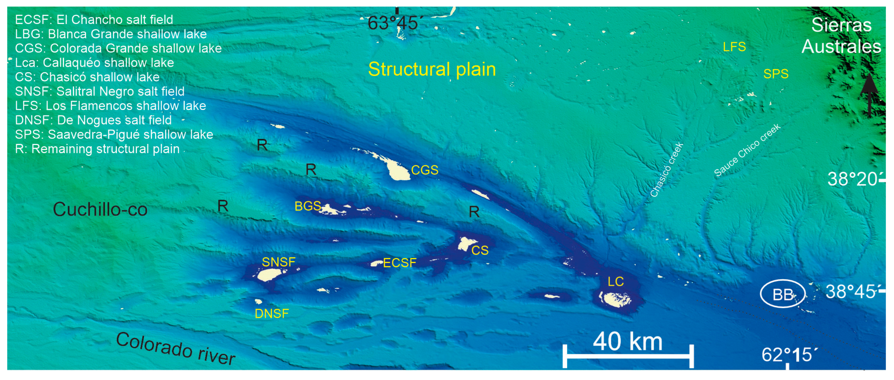
The depressed area to the north of the Colorado River, within the south sector of the corridors, crest, and playas domain (Figure 3), is formed by a series of deflation basins (Figure 3 and Figure 4), many of them currently shallow lakes or salt fields such as those of Las Coloradas Grande and Chasicó ending in the Bahía Blanca estuary. They are aligned and isolated or connected through thresholds or narrow and elongated plateaux forming continuous EW to NW-SW furrows. In this environment the headward fluvial erosion is conspicuous on the plateaux, leaving a calcareous paleosurface at the headwaters of the basins and in the steepest sectors of the depressions.
At the bottom of the playas and furrows, there are eolian deposits, with W-E main strike, forming dune bodies both stabilized and active, with transverse, barjanoid, and parabolic landforms, showing E, NE, and SE avalanche faces. According to the observations, these eolian deposits have a local origin. They would have been formed from the deflation of shallow and temporary lakes that are most of the time without water. The orientation of these landforms is coincident with the prevailing direction of the current winds, suggesting that wind direction must have been steady at least since the Pleistocene.
Although these depressions (playas and furrows) have been related to the basement structure [73] or fluvial action [74], exogenous processes related to the fluctuation of the coastline must be considered. In glacial periods, when the coastline was −130 or −150 m [75] and the climatic conditions were more arid, this large depression north of the Colorado River was under intense eolian erosion. The presence of elongated deflation basins, often interconnected, clearly suggests the wind’s action in their formation, highlighting the importance of these processes during the Quaternary.

3.1.2. Longitudinal Crests and Corridors

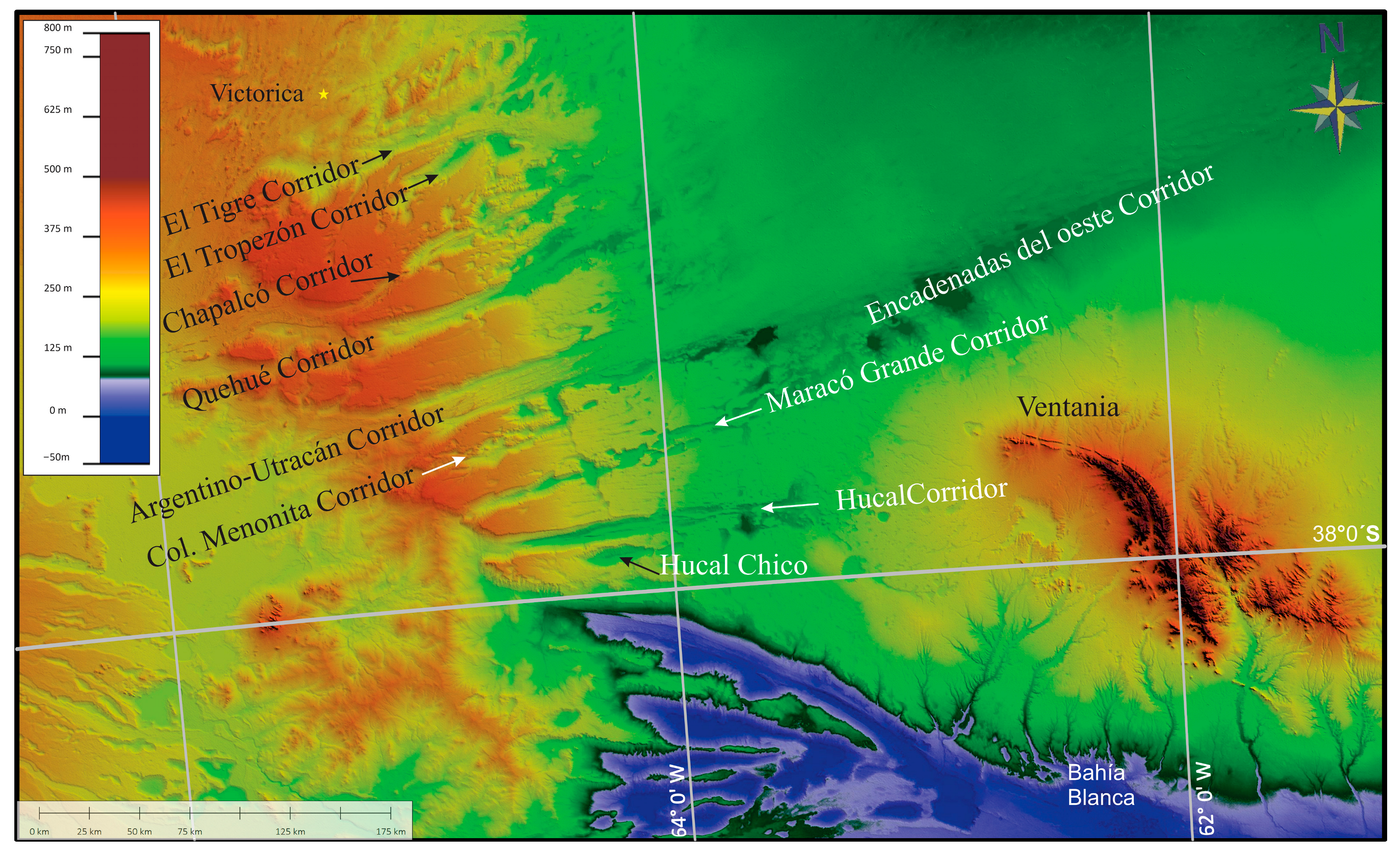
To the NE of the southern depression, within a 35° radius, there are nine divergent furrows near 80–100 km in length (Figure 5). From south to north, they are called: Hucal Chico, Hucal, Maracó Grande, Colonia Menonita, Argentino-Utracán, Quehué, Chapalcó, El Tropezón, and El Tigre, and are described below.
Hucal Chico Corridor: it is the southernmost and smallest furrow, formed by the union of two elongated deflation basins, oriented N 85° E. It is 40 km long, 6 km at maximum width, and 77 m deep, with a convergent drainage pattern separated from the furrow immediately north by a narrow crest 1 km wide. The north and south ends have serrated margins due to ravines, suggesting intense headward fluvial erosion.
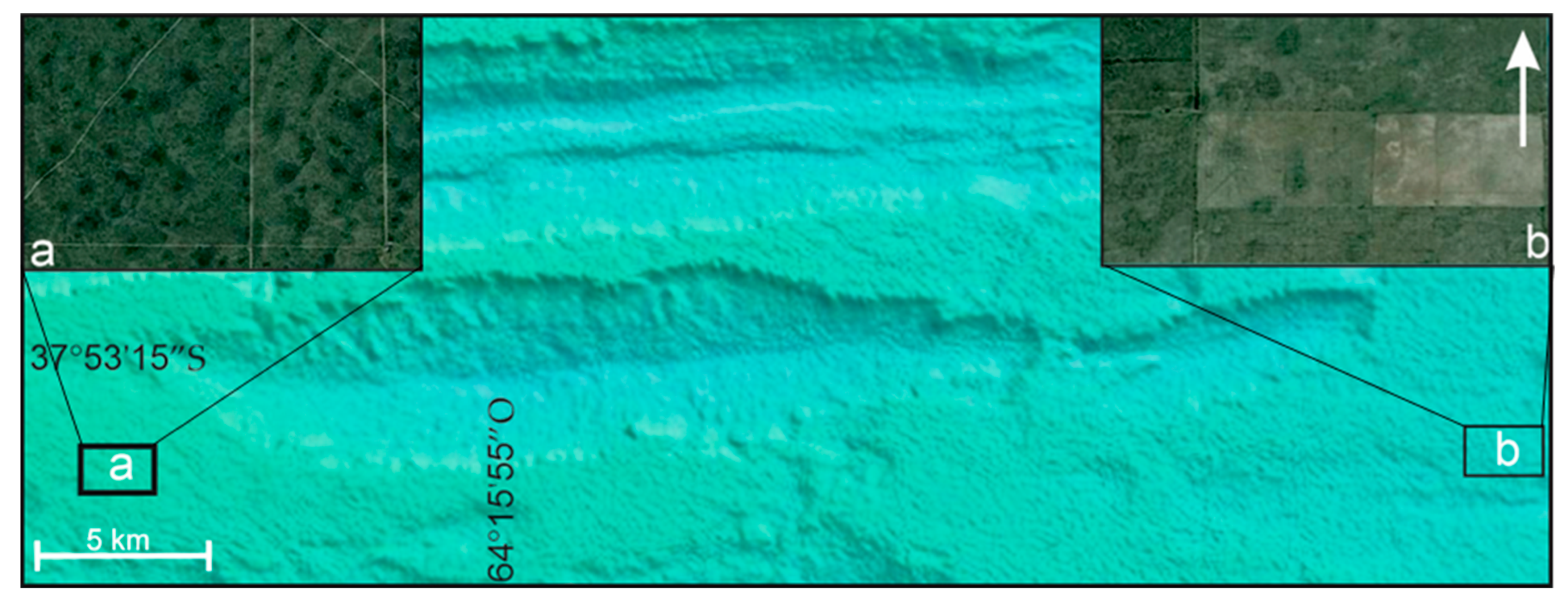
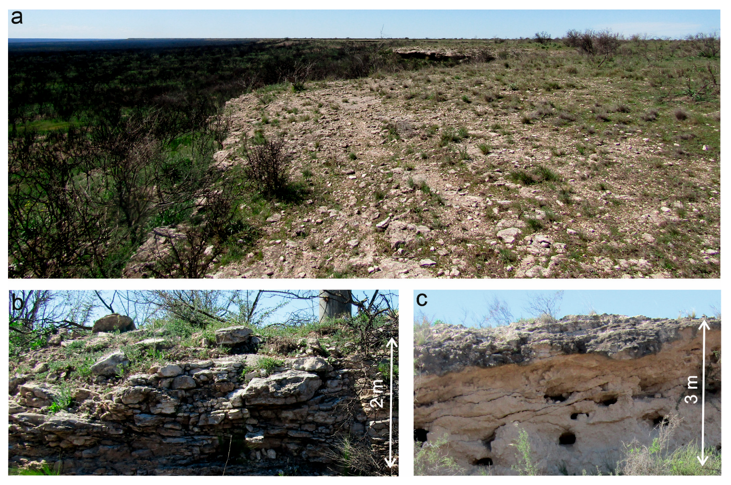
On the plain surrounding this furrow, there are scattered circular depressions or basins 100 m in mean diameter. To the east, these basins are circular, independent from each other, and uniformly distributed; to the west, they are wider, more irregular, and often connected to each other. These depressions are related to doline-like karstic forms produced by the dissolution of surface calcium carbonate, a process already recognized in the area [76,77]. These landforms are very common in areas with surface calcium carbonate; they are simple playas, rounded or oval and small, between a few meters up to 500 m in diameter. Dimensions, depth, and even origin of dolines are related to the thickness of the carbonate layer. According to Gvozdietskiy [78,79] and Corbel [80], dolines of the Hucal Chico furrow are pan or dish-like (Figure 6a,b) formed from the dissolution of calcium carbonate [76]. Because of this, climate is interpreted as the main factor in the generation of these landforms, also observed in modern environments with similar lithological characteristics [81].
Hucal Corridor: It is oriented N85° E, 110 km long, with a 6–7 km mean width and is 80 m deep. This furrow is best limited in the first 80 km of its western side, but in the final section (the 30 eastern km), it gradually blurs, being identified by the presence of isolated shallow lakes (Figure 5). Their margins are serrated because of headward fluvial erosion and mass-wasting processes. The bottom of the furrow is filled with discontinuous eolian deposits (stabilized barjanoid and parabolic forms), shallow lakes, and salinas. The eastern sector is occupied by shallow lakes inside depressions partially joined.
Maracó Grande Corridor: It is oriented N75° E, 100 km long, has a 6 km mean width and is 100 m deep. Their margins are irregular because of the capture of lowlands. The watercourses descend, channeled from the edges, and infiltrate at the bottom. At the eastern end, there are isolated lowlands that progressively join and continue into the shallow lakes west of Buenos Aires Province, known as the “Encadenadas del Oeste” formed by the Carhué, Guaminí, Cochicó, Alsina lakes, and others. The furrow that contains these shallow lakes is oriented N70° E, 140 km long, and is 15 km at maximum width. The bottom of these shallow lakes is 96 m asl at the SW end and 110 m asl at the NE end. This difference in height (nearly 15 m) causes a natural drainage close to the SW, which acts as the base level of the furrow, with the consequent precipitation of salts in arid periods, which are intensively exploited.
Colonia Menonita Corridor: It is oriented N77° E, 100 km long, 6 km wide, and 60 m deep. It is irregularly elongated with frequent narrowing and widening, suggesting the union of large deflation basins. Although the physical border is clear, there are isolated lowlands aligned in the same direction.
Argentino-Utracán Corridor: It is oriented N73° E, 130 km long, 30 km wide, and 40 m deep. The bottom is longitudinally stepped, forming different shallow lakes. A fringe 6 km wide, formed by parabolic and transverse dunes, favors the formation of shallow lakes in almost the entire NW margin. Two different dune systems may be recognized, the older one with lineal landforms and the younger one with pyramidal forms.
Quehué Corridor: It is oriented N71° E, 120 km long, 10 km wide, and nearly 80 m deep. It is occupied by stabilized dunes and shallow lakes often temporarily joined. Its NE sector bifurcates in another furrow oriented N56° E.
Chapalcó Corridor: It is oriented N60° E, toward Santa Rosa City, 65 km long, 10 km wide, and 50 m deep. It is discontinuous, with serrated margins produced by headward fluvial erosion (ravines), formed by deflation basins partially joined and dunes in its bottom. From the central sector eastwards there is a large amount of small furrows and crests, formed by the successive union of deflation basins, which strangle the furrow in some cases.
El Tropezón Corridor: Northwards, this furrow is oriented at N55° E, and is 40 km long, 7 km wide, and 60 m deep. It is formed by the union of individual playas with regional NE slope and a temporary shallow lake as the base level.
El Tigre Corridor: Further north, in a central position, there is a roughly defined furrow surrounded by shallower deflation basins connected or not connected with the main landform. Northeastwards it blurs gradually, while shallow playas with shallow lakes are aligned. Immediately northwards (in the vicinities of Victorica) there is a large number of elongated depressions aligned N35° E, notably parallel. These deflation basins are immersed in linear forms of eolian accumulation, which are stabilized, except those leeward of the shallow lakes.
According to the characteristics of these furrows, their genesis must have involved two main processes, weathering (dissolution) of the carbonatic surface that tops the sediments of the area, and eolian erosion by deflation of the Miocene deposits, which would have produced the oriented deflation basins, some of them united and others isolated. At the same time, the deflated material would have formed northeastwards of these furrows, the longitudinal and parabolic dune fields of western Buenos Aires, and loessic accumulations more distally.

3.2. Longitudinal Dunes and Parabolic Dunes: The Pampean Sand Sea

The Pampean Sand Sea (Mar de Arena Pampeano) [27] has landforms of eolian accumulation covering 200,000 km2 of the Bonaerian Sandy Pampa (Pampa Arenosa bonaerense). The sand, which came from the SW, was transported in two directions, producing different morphologies. The material transported to the NNE and N formed longitudinal morphologies, whereas that carried to the NE and E formed parabolic, transverse morphologies and dunes of silts (Figure 7).

3.2.1. Longitudinal Dunes

These are sandy ridges formed by simple linear dunes [82] arranged as an eastwards convex arc, because in the southern sector they are oriented SSW-NNE, and in the northern sector, N-S (Figure 7a). These dunes are strikingly parallel, about 100 km long and 12.5 km wide, separated from each other by corridors of 1–1.5 km [16].
Four lithostratigraphic and three pedostratigraphic units have been recognized in these deposits of the Buenos Aires Province [83], and the Meaucó Fm. in La Pampa Province [48]. This suggests a cyclical pattern in the movement and stabilization of landforms from the late Pleistocene to the Holocene. They have intercalations of lacustrine facies and paleosoils, comparable with molisols, which suggest milder humidity conditions than the current ones [84]. In San Luis Province, these deposits were dated using OSL at 42.7 and 41.4 Ka [85], with additional intervals of 190 ± 20 Ka, 70 ± 10 Ka, 40–32 Ka, 29–24 Ka, 22–17 Ka, and 12–1 Ka, separated by discontinuities or geosoils [67], while in Junín, an age of 7.3 Ka was obtained at a depth of 1.5 m [52], suggesting arid conditions during the late Pleistocene to Holocene.

3.2.2. Parabolic Dunes

These 4 km wide dunes are laterally symmetric, asymmetric, and coalescent, covering 20,000 km2 [86] with displacements from SW to NE (Figure 7b). In most cases, these morphologies are associated with rounded or elongated deflation holes, currently occupied by shallow lakes, that, when joined, generate incipient runoff lines. Kruck et al. [52] obtained IRSL ages of these landforms in Cochico/Alsina (5.0 Ka), Pirovano (6.7 Ka), Bolivar (10.6 Ka), and Saladillo (14.2 Ka). Likewise, Tripaldi et al. [87] obtained ages from 12.6 Ka up to 2.6 Ka near Bolivar with superficial pedological development. These ages confirm the arid conditions of the central–western region of the study area up to the late Holocene, which were grouped in the de la Riestra Fm. [3].

3.3. Playas and Lunnetes

Towards the NE lowlands, deflation basins or playas are formed, being another geomorphological feature generated mainly by eolian action. These forms have been defined as closed depressions, free of vegetation, in arid and semiarid zones, whose flat bottom is under periodic or sporadic flooding and salt precipitation by evaporation [24]. They are common in many regions below the 500 mm isohyet, with highly variable sizes and densities [88].
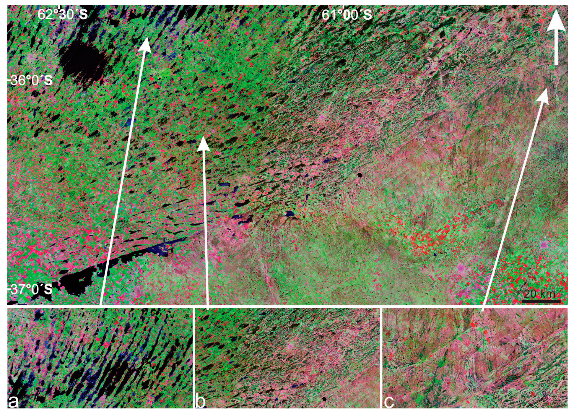
Deflation basins: These landforms produced by deflation are widely distributed and developed in almost the entire depression of the Salado, carved in the loessic sediments of the Pampeano Fm. [5,89]. Most of these basins are occupied by permanent or semi-permanent shallow lakes, and are filled with gypsum muds and carbonates arranged intrasedimentary in continuous layers or in rosettes, evidencing alternating dry and humid periods, and the influent–effluent character in which they were developed [90,91,92].
The formation of these deflation basins is associated with a set of processes. The precipitation of salts generates loose particles by haloclasty, causing the pelletization of the clay particles reaching the size of silt and sand, which are easily displaced by the wind through rolling, saltation, and suspension. Consequently, the deepening and widening of the playas by pelletizing processes favor deflation, being more efficient the greater the number of cycles of flooding and drying. [24].
Deflation basins can also be observed on the Coastal Plain, a littoral environment product of the last marine transgression [66,93]. But their characteristics are different from the continental ones in the depth and development of lunettes, since in most cases the latter are arranged around their entire circumference, indicating variable directions of the winds. These playas have marine components of the MIS 1 within their limonic components, while the playas located in exclusively continental regions, subjected to water deficit during the middle Holocene, have no record of deflation processes.
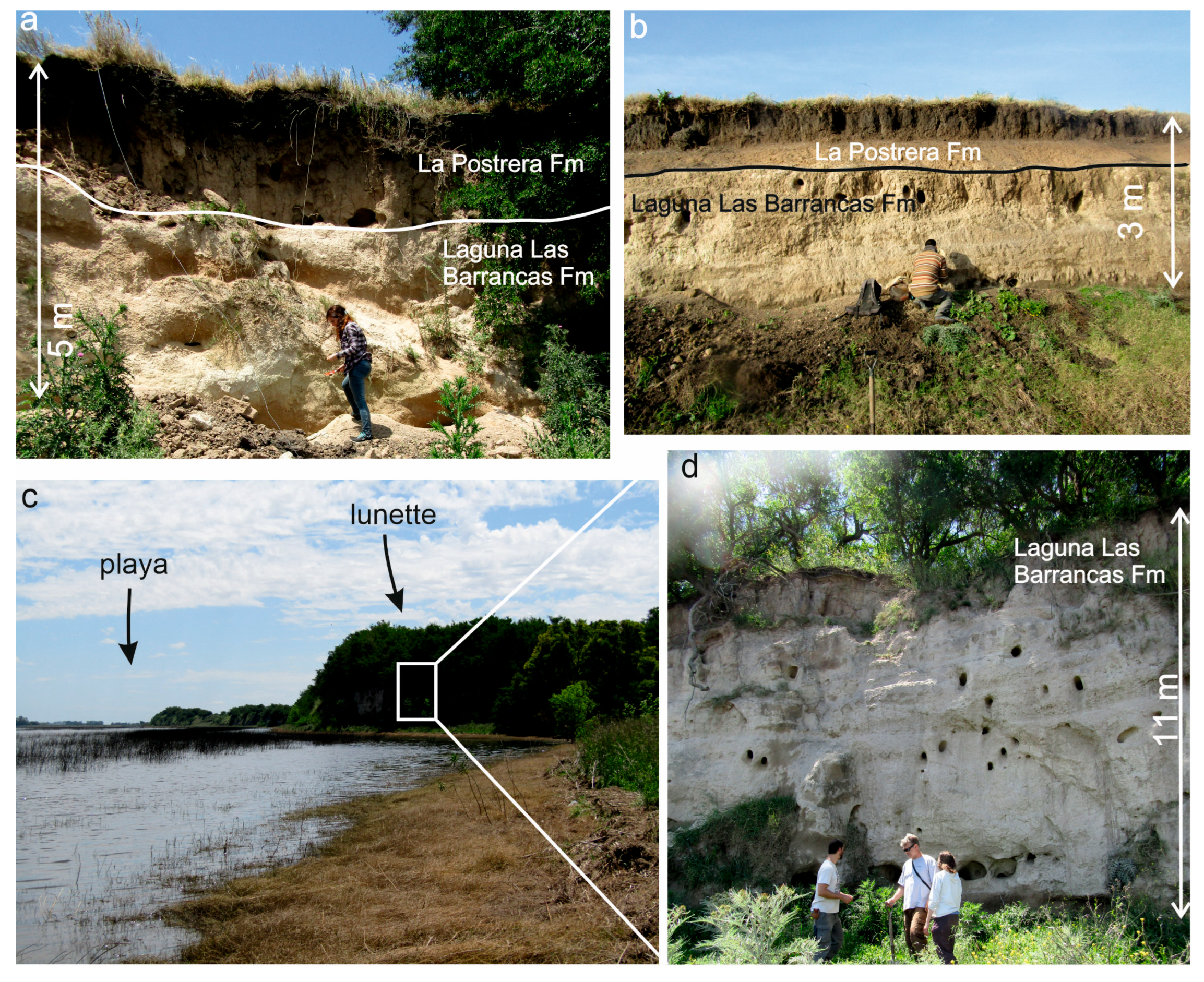
Lunettes: They are crescent-shaped eolian deposits which develop to the E and NE of the playas (except those of the Coastal Plain) as a result of the deflation of the latter in periods of drought (Figure 8). They are made up of clay pellets, light brown to yellowish in color, flocculated into sand and coarse silt particles, which give the sediment a pseudo sandy silt texture. They also have small root-like calcretes, iron–manganese concretions, gypsum crystals, and a few redeposited fossil remains [89], in addition to paleosols that contribute to their resistance. These sediment accumulations occur during dry periods when deflation expands the size of the beaches [88].
In some cases, these morphologies exceed 15 m high in relation to the bottom of the shallow lakes, with several erosive–sedimentary cycles [89,93] evidencing the alternation of paleoclimatic conditions, whose intensity depended on the time of action and how extreme these conditions were. Different lithological units have been identified in the lunettes; most of them can be associated with the Late Pleistocene, most likely with the last glaciation (5,91), although their origin surely began in the Middle Pleistocene in periods with water deficit. In recent times, during years of extreme droughts (e.g., 2010–2011), important dust storms have occurred in many dry shallow lakes from the deflation of the bottom. These deposits were originally grouped together in the La Postrera Fm. with other loess deposits [33]. Recently, they have been grouped in the Lagunas Las Barrancas Fm. because of their particular distribution, being associated exclusively with the deflation basins [3] (Figure 7). Although, in some lunnetes of the La Postrera Fm., a reduced thickness of no more than one meter can be observed, associated with regional transport and sedimentation during the Holocene.

3.4. Mantiform Loess and Transverse Silt Dunes

They are distributed to the E of the Pampean Sand Sea, interrupted by the Playas and lunettes of the Salado Depression (Figure 3). They are composed of silty sediments transported further than sand.
They can be grouped in specific places forming transverse ridges, which are tenuous NW-SE to NS lines, 150 to 200 m wide and several km long, separated by depressions of equal dimensions and not exceeding 0.50 m in relative height [5,94]. These forms would have been produced by SW and W winds (the same ones that generated the deflation basins, lunettes, parabolic dunes, and deflation holes), but due to the underdeveloped soil and their friable consistency, they are considered chronologically younger than the lunettes, and could be associated with one of the eolian events recognized in the SE of the province of Buenos Aires for the Late Holocene [37].
Fidalgo [33] and Pommarés et al. [3] described them as silty mantiform deposits, brownish in color, referable to the La Postrera Fm. (Figure 9). They were dated at 17.9 Ka at General Belgrano (IRSL, [52]); 20,705 ± 990 [65] at Puente de Pascua; 30,185 ± 1640 at Gral. Conesa; 11,125 ± 800 Ka [3] at Alberti; 6470 ± 425 Ka at Pila; 4540 Ka [95]; 4080 Ka [96]; 2990 Ka as minimum age [97]; and 750 years A.P [94], suggesting several arid cycles in the region, not only in the Upper Pleistocene but also in the middle Holocene. In the Pampa Ondulada (Undulated Pampa) these loessic deposits discontinuously cover most of the surface, with little thickness, being the youngest in age from the late Pleistocene [52,98].

4. Discussion

4.1. Paleoclimatic Influence and Eolian Processes

The southern sector of the Pampean Plain displays an extensive record of aeolian deposition, where loess is the most prominent in terms of thickness and spatial distribution e.g., refs [5,17,18,19,99]. However, during episodes of increased aridity—especially under glacial conditions—deflation, abrasion, and fluvial reworking likely led to intense erosional activity. In some areas, these processes were the primary agents shaping the current landscape morphology.
At present, the eastern portion of La Pampa province lies within a semi-arid climatic zone. Nonetheless, during glacial periods, regional precipitation would have been even lower, accompanied by significantly colder temperatures. These harsher conditions are believed to have promoted the development of prominent erosive features. In Patagonia, for instance, Quaternary periglacial phenomena such as polygonal ground and ice-wedge casts have been documented and linked to the Last Glacial Maximum (LGM), suggesting a regional temperature decrease of up to 14 °C [99,100,101,102,103].
Several studies concur that mid- and high-latitude regions of the Southern Hemisphere during the LGM were characterized by cold, dry, and windy climates [37]. These reconstructions are supported by the widespread presence of loess and aeolian sand sheets, the occurrence of various paleoenvironmental proxies, and simulations from the COHMAP project [104]. Shifts in atmospheric circulation patterns—particularly the positioning and intensity of the Pacific and Atlantic anticyclonic cells—likely played a major role in driving paleoclimatic variability across southern South America.
Wind dynamics, especially during the LGM, were a dominant geomorphic force across the Pampean Plains, with prevailing winds from the west and southwest, consistent with regional paleowind models [20]. The orientation of erosional and depositional aeolian landforms identified in this study supports this interpretation. Additionally, the northward migration of the Southern Westerlies and the intensification of dry downslope winds leeward of the Andes—enhanced by the expansion of ice bodies—would have further contributed to deflation and sediment mobilization [105].
An estimated 200 km3 of material was eroded from the fluvial–aeolian furrow systems carved into the Cerro Azul Formation. This volume is equivalent to a deposit covering an area of 150 km × 150 km at 10 m thickness, not accounting for additional eroded surfaces immediately west of the furrows. Much of this eroded sediment may have been redistributed into the Pampean Sand Sea and the surrounding loess belt [19], thus linking localized geomorphic change to regional-scale sedimentary systems.
Such alternation between cold glacial phases and warmer interglacial periods, as well as transitional climatic states, gave rise to highly contrasting environmental conditions across the Pampean region. In the southern sector—currently semi-arid—glacial intervals likely brought even more extreme climatic stress. These local paleoenvironments were ultimately shaped by global climatic oscillations [106,107], further emphasizing the sensitivity of the region to long-term atmospheric and hydrological shifts.

4.2. Exogenous Processes as Drivers of Furrow Formation

Previous studies in the area proposed two hypotheses on the origin of these furrows, one related to endogenous processes and the other to exogenous processes. Cordini [108] stated they were grabens with little throw; Linares et al. [32] related them to structures limited by transcurrent faults or strike-slip, and de Elorriaga and Visconti [109] considered both a tectonic and exogenous origin, although it should be noted that there is no evidence of faulting in the surface [73,110]. The other group of hypotheses relates these furrows to exclusively exogenous processes. Tapia [111] and Terraza et al. [112] suggested an erosive origin without delving into their typology. Malagnino [113] suggested that these are geomorphological features related to variations in the Salado River, with an eastward flow direction during the Quaternary. While Calmels [114], Lorenz [76], and Kruck et al. [52] assigned a combination of karstic, eolian, and fluvial processes for their origin.
Several papers relate deep structures with superficial features [42,73], but these are not directly related to depressions. Moreover, most of them are transverse to the deep structures. In sum, these landforms have been already studied but mainly from a morphological standpoint. Here we propose their origin as a result of exogenous processes related to hyper-arid environments (<50 mm) [81], with strong unimodal winds related to glacial periods [115], which would cause deflation and eolian abrasion of substrates with little or null vegetation cover, formed by relatively homogeneous rocks, such as the ones reported for the deserts of Atacama and Namibia for pre-Pleistocene times [116].
In karstic environments, weakness lines produced by tectonism are commonly first attacked by carbonatic dissolution, giving rise to elongated dolines following the direction of the structures, or star-shaped forms in their intersection. However, the depressions in the study area are randomly distributed, without any kind of pattern or structural control.
The structural surface surrounding the furrows is formed by a calcium carbonate layer 1 to 3 m thick, bending slightly (0.2%) to the E [42]. Several deflation basins and dolines are developed on this surface, and different carbonate levels have been recognized below [117] suggesting several episodes of landscape stabilization. The numerical ages of the layer are near 20 Ka [52], but, because of the precipitation–dissolution processes, these must be considered as minimum ages (Figure 10).

4.3. Orientation and Evolution of Aeolian Furrows and Deflation Landforms

The orientation of the furrow varies from E-W in the southern sector to SW-NE to the north, and if the Bahía Blanca estuary is also taken into account, furrows would also be NW-SE. These orientations are also reflected in the numerous deflation basins over the plateau, connected or not to each other and to the furrows. Likewise, the accumulation forms to the E and N of the study area (parabolic and longitudinal dunes), as well as the deflation basins of the Salado depression, are also oriented N-S and SW-NE. These morphologies are associated with the last glaciation [16,118], and their orientation suggests the approximate location of the different anticyclonic centers during their formation.
The lithology of the Cerro Azul and Pampeano formations largely favored the deflation, abrasion, weathering, and fluvial processes responsible for the generation of these morphologies. The dissolution of the calcium carbonate and the consequent formation of dolines are the first steps in the formation of furrows. As the dissolution progresses, the fluvial erosion increases, gradually giving rise to the connection of these depressions and the definitive breakdown of the carbonate layer. Once the depression is consolidated, the wind action in combination with the fluvial action would have caused the elongation of the dolines, resulting in the formation of playas, mainly in the direction of the winds. The subsequent coalescence of these playas would have produced elongated depressions through which the winds, loaded with sand and silt of the deflation of the sediments of the W and the outcrops of the Cerro Azul Fm., circulated. To the east, the sediments would have been distributed on the surface when winds lost confinement, either as longitudinal and parabolic dunes in the proximal sectors or as mantiform silty deposits in the most distal positions. These processes were favored by the height of the structural plain (carbonate layer), as well as by the presence of the furrows (see above), which prompted the movement mainly through these depressions. Finding these morphologies at different stages of development means the formation was gradual over time. The most structured are most likely the oldest, since they have been modeled the longest.
The continuity of these depressions is interrupted towards the E and NE, grading to less clear and individual forms, distributed on the wide plain. Where the Encadenadas shallow lakes of the west of the province of Buenos Aires are developed, as well as those described in the E of La Pampa, the less-defined furrow responds to a lower topography, with a more superficial water table and the presence of vegetation, which would have diminished the action of the eolian processes. Outside the furrows, the wind loses its channeling, significantly reducing the erosion and increasing the accumulation processes.
The study of sand accumulations at the bottom of the furrows allowed us to identify deposits from the Late Pleistocene–Middle Holocene and the Upper Holocene [119]. Likewise, the numerical ages for the sand dunes of General Acha and Toay yielded values from the Middle Holocene to the present (5.4 Ka, 5 Ka, 2.3 Ka, 3.8 Ka, and 0.3 Ka, according to [52] suggesting arid conditions even in post-glacial times.
To the NE, at the Salado depression, a series of small depressions were developed in association with karst and deflation processes, with a gradation in size and density. This area is also where the deflation basins and associated lunettes are best developed, and in many cases contain significant proportions of gypsum [17,66] from surrounding ancient water bodies.
The development of lunettes is closely related to the climate. They hardly form and the deflated material spreads to distal sectors in places of extreme climate. On the contrary, where rainfall is more important, the vegetation retains the sediment, favoring its deposit in proximal places, as would have happened to the East of the Salado depression. At the same time, beaches devoid of water for a long time, whether superficial or underground, will also favor the development of lunettes.
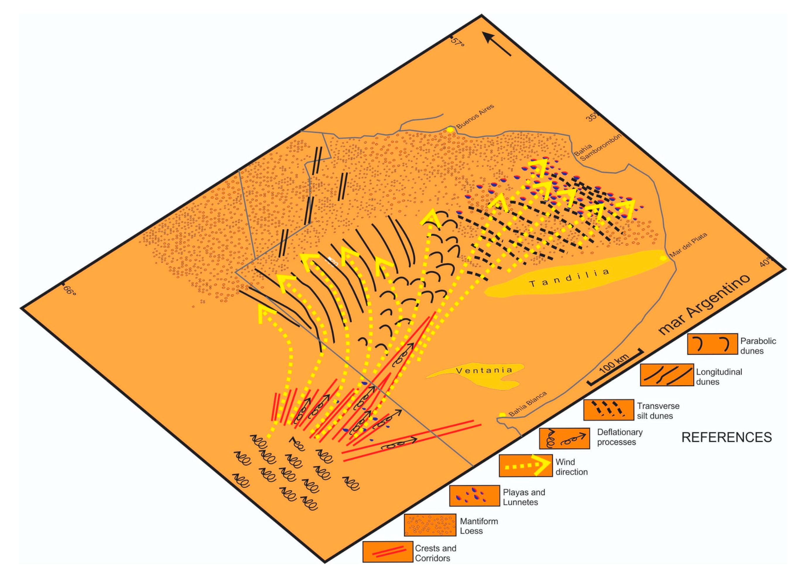
Figure 11 illustrates the spatial consistency between corridor orientation, dune alignment, and deflation structures across the southern region. The dominant wind directions—primarily from the southwest and west—are expressed in both erosional and depositional features, reflecting coherent aeolian dynamics under predominantly arid Late Quaternary conditions. The figure also emphasizes the role of the topographic confinement by structural highs and corridors in channeling sediment transport and shaping landform distribution.
Altogether, the spatial arrangement, orientation, and development stages of these landforms support a model of landscape evolution driven primarily by aeolian dynamics under glacial climatic conditions, enhanced by karstic and fluvial contributions, and modulated by the lithological and structural characteristics of the region.

4.4. Implications for Land Use and Environmental Management

The aeolian imprint on the southern Pampas landscape carries significant implications for land use planning and environmental management. Several of the deflation basins and shallow depressions identified in this study are associated with seasonal water retention, temporary wetlands, and potential soil degradation—factors that can influence land suitability for agriculture and grazing [120]. The stratigraphic and geomorphological evidence underscores a long-term sensitivity of this region to climatic fluctuations, particularly under arid phases that promoted extensive wind erosion and sediment redistribution [121].
These processes are not only of geological interest but remain active under present and projected climatic variability. Increased frequency and intensity of droughts could intensify wind deflation, the desiccation of shallow lakes, and the reactivation of dunes, leading to the further loss of topsoil and the disruption of local hydrological networks [122]. The drying and degradation of lacustrine environments, in particular, can interrupt drainage connectivity, amplify flooding beyond typical floodplains, and alter ecosystem dynamics by reshaping the availability of water and nutrients.
Such changes can have cascading effects on local flora and fauna, especially in a region already experiencing high levels of ecological disturbance. Vegetation shifts, habitat fragmentation, and soil salinization may become more widespread, reinforcing cycles of degradation and reducing the resilience of both natural ecosystems and agricultural systems.
In this context, the geomorphological insights provided by this study offer a valuable framework for identifying vulnerable areas and guiding sustainable land management practices. The patterns documented here can inform risk assessments and adaptation strategies not only in the Pampas but also in other temperate plains undergoing similar environmental pressures worldwide.

5. Conclusions

  • The longitudinal depressions to the east of La Pampa and the west of Buenos Aires are furrows primarily formed by aeolian action, with contributions from other geomorphological processes such as weathering, fluvial activity, and mass wasting. These landforms developed under climatic conditions more extreme than those of the present, in connection with global glacial events. Their origin reflects an evolutionary sequence that begins with karstic processes and continues with erosional mechanisms, mainly aeolian (deflation, abrasion), fluvial (ravine development), and slope-related. Aeolian processes may have initiated small depressions (dolines) through the dissolution of the carbonate layer that caps the regional sediments, while the other processes significantly contributed to their enlargement in the direction of prevailing winds, leading to their integration and the consolidation of the furrows.
  • The orientation of the furrows reflects the directions of the winds in time and latitude, which is also reflected in the accumulation shapes, both of sand dunes and silt, generated by winds from the W and the S, covering the entire quadrant.
  • Some of the sandy deposits of the Pampean Sand Sea, and the more distant loess deposits located, likely derive from the deflated material of the Cerro Azul Fm. from the furrows, mobilized under extreme climatic conditions.
  • The longitudinal and parabolic dunes record the direction of prevailing winds, from the southern to the western quadrant. Their numerical ages indicate the time of formation and the continuity of these winds, from the Late Pleistocene to the Late Holocene, particularly in the central west of the study area.
  • At the center and NE of Buenos Aires Province, the main features are the deflation basins and lunettes, mantiform loess, and silty transverse dunes, with winds coming from W and SW and ages ranging from the late Pleistocene to the Middle Holocene, indicating a sustained water deficit during most of this period.
  • Beyond their geomorphological significance, these aeolian landscapes highlight the sensitivity of the landscape to climatic variability. Understanding their spatial distribution and evolution provides useful insights for identifying areas of potential environmental vulnerability and for guiding sustainable land management in comparable temperate plains.

Author Contributions

Conceptualization, E.F.; Validation, Y.R., L.G., M.L. and M.F.P.; Investigation, E.F. and Y.R.; Writing—original draft, E.F.; Writing—review and editing, Y.R., L.G. and M.L., Sebastiano S.D. and M.F.P.; Visualization, E.F.; Supervision, E.F.; Funding acquisition, E.F. and L.G. All authors have read and agreed to the published version of the manuscript.

Funding

This work was partially funded by: 11N/924. Quaternary paleoenvironmental indicators in the Pampas region and their relationship to global climate cycles. PID-UNLP. SD and LG have been partially supported by the Xjenza Malta RNS Programme, 2024–2025.

Data Availability Statement

The original contributions presented in this study are included in the article. Further inquiries can be directed to the corresponding author.

Acknowledgments

Generative AI tools (ChatGPT4.0, based on GPT-4, by OpenAI) were used to improve the clarity and grammar of the English language in the manuscript and cover letter. All scientific content, interpretations, and conclusions were developed entirely by the authors.

Conflicts of Interest

The authors declare no conflict of interest.

References

  1. Groeber, P. Mineralogía y Geología. Espasa-Calpe: Buenos Aires, Argentina, 1938; 492p. [Google Scholar]
  2. Iriondo, M. Geomorfología y Cuaternario de la provincia Santa Fe (Argentina). D’Orbignyana Corrientes 1987, 4, 1–54. [Google Scholar]
  3. Pommarés, N.; Fucks, E.; Pisano, F.; Luengo, M.; Ramos, N.; Di Lello, C. Late Pleistocene-Holocene paleoenvironments in the middle basin of the Salado river, province of Buenos Aires, Argentina. J. S. Am. Earth Sci. 2021, 105. [Google Scholar] [CrossRef]
  4. Ramos, V.A. Las provincias geológicas del territorio argentino. Geol. Argent. 1999, 29, 41–96. [Google Scholar]
  5. Fucks, E.; Deschamps, C. Depósitos continentales cuaternarios en el noreste de la provincia de Buenos Aires. Rev. Asoc. Geológica Argent. 2008, 63, 326–343. [Google Scholar]
  6. Berger, A. Milankovitch theory and climate. Rev. Geophys. 1988, 26, 624–657. [Google Scholar] [CrossRef]
  7. Caldenius, C.C.Z. Las glaciaciones cuaternarias en la Patagonia y Tierra del Fuego: Una investigación regional, estratigráfica y geocronológica—Una comparación con la escala geocronológica sueca. Geogr. Ann. 1932, 14, 1–164. [Google Scholar] [CrossRef]
  8. Mercer, J. Cenozoic glaciation in the Southern Hemisphere. Annu. Rev. Earth Planet. Sci. 1983, 11, 99–132. [Google Scholar] [CrossRef]
  9. Meglioli, A. Glacial Geology of Southernmost Patagonia, the Strait of Magellan and Northern Tierra del Fuego. Ph.D. Thesis, Lehigh University, Bethlehem, PA, USA, 1992. [Google Scholar]
  10. Rabassa, J.; Coronato, A.; Salemme, M. Chronology of the Late Cenozoic Patagonian Glaciations and their correlation with biostratigraphic units of the Pampean Region (Argentina). J. S. Am. Earth Sci. 2005, 20, 81–103. [Google Scholar] [CrossRef]
  11. Clague, J.J.; Barendregt, R.W.; Menounos, B.; Roberts, N.J.; Rabassa, J.; Martinez, O.; Ercolano, B.; Corbella, H.; Hemming, S.R. Pliocene and Early Pleistocene glaciation and landscape evolution on the Patagonian Steppe, Santa Cruz province, Argentina. Quat. Sci. Rev. 2020, 227, 105992. [Google Scholar] [CrossRef]
  12. Feruglio, E. Descripción Geológica de la Patagonia. Dirección General de Yacimientos Petrolíferos Fiscales, Tomo 1; Impr. y Casa Editora “Coni”: Buenos Aires, Argentina, 1950. [Google Scholar]
  13. Codignotto, J.O.; Kokot, R.R.; Marcomini, S.C. Neotectonism and sea level changes in the coastal zone of Argentina. J. Coast. Res. 1992, 8, 125–133. [Google Scholar]
  14. Schellmann, G. Coastal development in Southern South America (Patagonia and Chile) since the younger Middle Pleistocene sea level changes and neotectonics. In German Geographical Coastal Research: The Last Decade; Kelletat, D., Ed.; IGU Sonderband; Institutefor Scienti c Co-operation Tübingen: Tübingen, Germany, 1998; pp. 289–304. [Google Scholar]
  15. Rutter, N.; Schnack, E.; Del Río, L.; Fasano, J.; Isla, F.; Radtke, U. Correlation and dating of Quaternary littoral zones along the Patagonian coast, Argentina. Quat. Sci.Rev. 1989, 8, 213–234. [Google Scholar] [CrossRef]
  16. Fucks, E.; Luengo, M.; D’Amico, G.; Pommarés, N.; Florencia Pisano, M.; Penzo, H. Influence of Quaternary sea level changes in the littoral of Chubut, Argentina. J. S. Am. Earth Sci. 2018, 88, 589–598. [Google Scholar] [CrossRef]
  17. Teruggi, M.E. The nature and origin of the Argentine loess. J. Sediment. Petrol. 1957, 27, 322–332. [Google Scholar]
  18. Sayago, J. The Argentinian neotropical loess: An overview. Quat. Sci. Rev. 1995, 14, 755–766. [Google Scholar] [CrossRef]
  19. Iriondo, M.H.; Krohling, D. The tropical loess. In Quaternary Geology: Proceedings of the 30th International Geological Congress, Beijing, 1997; An, Z., Zhou, W., Eds.; CRC Press: Boca Raton, FL, USA, 1997; Volume 21, pp. 61–77. [Google Scholar]
  20. Zárate, M. Loess of southern South America. Quat. Sci. Rev. 2003, 22, 1987–2006. [Google Scholar] [CrossRef]
  21. Visconti, G.; Melchor, R.N.; Montalvo, C.I.; Umazano, A.M.; Elorriaga, E.E. Análisis litoestratigráfico de la Formación Cerro Azul (Mioceno Superior) en la provincia de La Pampa. Rev. Asoc. Geológica Argent. 2010, 67, 257–265. [Google Scholar]
  22. Buschiazzo, D.E.; Taylor, V. Efectos de la erosión eólica sobre algunas propiedades de suelos de la Región Semiárida Pampeana Central. Cienc. Del Suelo 1993, 10/11, 46–53. [Google Scholar]
  23. Galone, L.; Panzera, F.; Colica, E.; Fucks, E.; Carol, E.; Cellone, F.; Rivero, L.; Agius, M.R.; D’Amico, S. A Seismic Monitoring Tool for Tidal-Forced Aquifer Level Changes in the Río de la Plata Coastal Plain, Argentina. Sustainability 2024, 16, 1432. [Google Scholar] [CrossRef]
  24. Gutiérrez Elorza, M.; Desir, G.; Gutiérrez-Santolalla, F.; Marín, C. Origin and evolution of playas and blowouts in the semiarid zone of Tierra de Pinares (Duero Basin, Spain). Geomorphology 2005, 72, 177–192. [Google Scholar] [CrossRef]
  25. Goudie, A. Wind erosional landforms: Yardangs and pans. In Aeolian Environments, Sediments and Landforms; Goudie, A.S., Livingstone, I., Stokes, S., Eds.; Wiley: Chichester, UK, 1999; pp. 167–180. [Google Scholar]
  26. Cano, E.; Fernández, B.; Montes, M. Vegetación—Inventario Integrado de los Recursos Naturales de La Provincia de La Pampa; Ediciones INTA: Buenos Aires, Argentina, 1980. [Google Scholar]
  27. Iriondo, M. The Upper Holocene dry climate in the Argentine plains. Quat. South Am. Antart. Penins. 1990, 7, 197–218. [Google Scholar]
  28. Rolleri, E.O. Provincias geológicas bonaerenses. In Geología de la Provincia de Buenos Aires; 6º Congreso Geológico Argentino, (Congress): La Plata, Argentina, 1975; pp. 29–54. [Google Scholar]
  29. Fidalgo, F. Provincia de Buenos Aires continental. In El Holoceno en la Argentina; En Iriondo, M., Ed.; Cadinqua: Buenos Aires, Argentina, 1992; pp. 23–38. [Google Scholar]
  30. Fucks, E.; Pisano, F.; Carbonari, J.; Huarte, R. Aspectos geomorfológicos del sector medio e inferior de la pampa deprimida, provincia de Buenos Aires. Rev. De La Soc. Geológica De España 2012, 25, 107–118. [Google Scholar]
  31. González Bonorino, F. Mineralogía de las fracciones arcilla y limo del Pampeano en el área de la ciudad de Buenos Aires y su significado estratigráfico y sedimentológico. Rev. Asoc. Geológica Argent. 1965, 20, 67–150. [Google Scholar]
  32. Linares, E.; Llambías, E.; Latorre, C. Geología de la Provincia de La Pampa, República Argentina y cronología de sus rocas metamórficas y eruptivas. Rev. Asoc. Geológica Argent. 1980, 35, 87–146. [Google Scholar]
  33. Fidalgo, F. Geología superficial de la llanura bonaerense. In Geologia de la Provincia de Buenos Aires, VI Congreso Geologico Argentino (Congress); Asociación Geologica Argentina: Bahía Blanca, Argentina, 1975. [Google Scholar]
  34. Riggi, J.F.; Fidalgo, F.; Martínez, O.; Porro, N. Geología de los “Sedimentos Pampeanos” en el Partido de La Plata. Rev. Asoc. Geológica Argent. 1986, 41, 316–333. [Google Scholar]
  35. Tonni, E.P.; Fidalgo, F. Consideraciones sobre los cambios climáticos durante el Pleistoceno Tardío-Reciente en la Provincia de Buenos Aires. Aspectos Ecológicos y Zoogeográficos Relacionados. Ameghiniana 1978, 15, 235–253. [Google Scholar]
  36. Imbelloni, P.; Cumba, A. Una sucesión de paleosuelos superpuestos del Pleistoceno medio-tardío, Holoceno. Zona sur de la Plata, Provincia de Buenos Aires. Rev. Asoc. Argent. De Sedimentol. 2003, 10, 3–21. [Google Scholar]
  37. Zárate, M.; Blasi, A. Late Pleistocene and Holocene deposits of the southeastern Buenos Aires province, Argentina. Geojournal 1991, 24, 211–220. [Google Scholar] [CrossRef]
  38. Bidegain, J.C.; Rico, Y. Mineralogía magnética y registros de susceptibilidad en sedimentos cuaternarios de polaridad normal (Brunhes) y reversa (Matuyama) de la cantera de Juárez. Rev. Asoc. Geológica Argent. 2004, 59, 451–461. [Google Scholar]
  39. Sayago, J.M.; Collantes, M.M.; Karlson, A.; Sanabria, J. Genesis and distribution of the Late Pleistocene and Holocene loess of Argentina: A regional approximation. Quat. Int. 2001, 76, 247–257. [Google Scholar] [CrossRef]
  40. Goin, F.; Montalvo, C.; Visconti, G. Los marsupiales (Mammalia) del Mioceno superior de la Formación Cerro Azul (provincia de La Pampa, Argentina). Estud. Geol. 2000, 56, 101–126. [Google Scholar] [CrossRef]
  41. Visconti, G. Sedimentología de la Formación Cerro Azul (Mioceno superior) en la Provincia de La Pampa. Ph.D. Thesis, Universidad de Buenos Aires (inédita), Buenos Aires, Argentina, 2007; 203p. [Google Scholar]
  42. Folguera, A.; Zárate, M. La sedimentación neógena continental en el sector extrandino de Argentina central. Rev. Asoc. Geol. Argent. 2009, 64, 692–712. [Google Scholar]
  43. Döering, A.; Berg, C.; Niederlein, G. Informe Oficial de la Comisión Agregada al Estado Mayor General de la Expedición al Río Negro (Patagonia) Realizada en los Meses de Abril, Mayo y Junio de 1879, Bajo las Órdenes del General Julio A. Roca; III Parte, Geología; Imprenta de Ostwald y Martinez: Buenos Aires, Argentina, 1881; pp. 299–530. [Google Scholar]
  44. Stappenbeck, R. Investigaciones Hidrogeológicas de los valles de Chapalcó y Quehué y de sus alrededores (Gobernación de La Pampa). In Dirección General de Minas, Geología e Hidrogeología; Boletín 4, Serie B (Geología); Talleres de la Dirección Meteorológica: Buenos Aires, Argentina, 1913; pp. 1–55. [Google Scholar]
  45. Salso, J.H. La cuenca de Macachín, provincia de La Pampa. Rev. Asoc. Geol. Argent. 1966, 21, 107–117. [Google Scholar]
  46. Pascual, R. Un nuevo Cardiomyinae (Rodentia, Caviidae) de la Formación Arroyo Chasicó (Plioceno inferior) de la provincia de Buenos Aires. Ameghiniana 1961, 2, 61–72. [Google Scholar]
  47. Pascual, R.; Bocchino, A.R. Un nuevo Borhyacninae (Marsupialia) del Plioceno medio de Hidalgo (La Pampa). Ameghiniana 1963, 3, 97–107. [Google Scholar]
  48. Giai, S.B. Plan de Investigación de Aguas Subterráneas; Informe Preliminar (inédito), Dirección de aguas subterráneas, Ministerio de Obras Públicas de La Pampa: Santa Rosa, CA, USA, 1975; 56p. [Google Scholar]
  49. Giai, S.B.; Tullio, J.O. Características de los principales acuíferos de la provincia de La Pampa. Rev. Asoc. De Geol. Apl. A Ing. Ambiente 1998, 12, 51–68. [Google Scholar]
  50. Kemp, R.A.; Zárate, M.; Toms, P.; King, M.; Sanabria, J.; Arguello, G. Late quaternary paleosols, stratigraphy and landscape evolution in Nothern Pampa, Argentina. Quat. Res. 2006, 66, 119–132. [Google Scholar] [CrossRef]
  51. Zárate, M.A.; Kemp, R.A.; Toms, P.S. Late Quaternary landscape reconstruction and geochronology in the northern Pampas of Buenos Aires province, Argentina. J. S. Am. Earth Sci. 2009, 27, 88–99. [Google Scholar] [CrossRef]
  52. Kruck, W.; Helms, F.; Geyh, M.; Suriano, J.; Marengo, H.; Pereyra, F. Late Pleistocene-Holocene history of Chaco-Pampa sediments in Argentina and Paraguay. Quat. Sci. J. 2011, 60, 14. [Google Scholar] [CrossRef]
  53. Bidegain, J.C.; Jurado, S.S. Registros paleomagnéticos y magnetismo ambiental en la localidad de San Pedro, provincia de Buenos Aires, Argentina. Latinmag Lett. 2013, 3, 1–7. [Google Scholar]
  54. Bidegain, J.C.; Jurado, S.S.; Gómez Samus, M.I. Magnetoestratigrafía en una sucesión de loess/Paleosuelos del Pleistceno en Marcos Paz, Provincia de Buenos Aires. Rev. Asoc. Geol. Argent. 2011, 68, 606–614. [Google Scholar]
  55. Rico, Y.; Gómez Samus, M.L.; Mendoza, M.S.; Alfonso Ariza, A.M. Nuevos registros de polaridad magnética en la ciudad de La Plata, Argentina. Cienc. Tecnol. Mater. 2019, 9, 29–52. [Google Scholar]
  56. Schultz, P.H.; Zarate, M.; Hames, W.; Camilión, C.; King, J. A 3.3-Ma impact in Argentina and possible consequences. Science 1998, 282, 2061–2063. [Google Scholar] [CrossRef]
  57. Orgeira, M.J. Estudio paleomagnético de sedimentos del Cenozoico Tardío en la costa atlántica bonaerense. Rev. Asoc. Geol. Argent. 1987, 42, 362–376. [Google Scholar]
  58. Orgeira, M.J.; Valencio, D.A. Estudio paleomagnético de 1os sedimentos asignados al Cenozoico tardío aflorantes en la barranca de Los lobos, provincia de Buenos Aires. Actas IX Congr. Geol. Arg. 1984, 4, 162–173. [Google Scholar]
  59. Ruocco, M.I. A 3 Ma paleomagnetic record of coastal continental deposits in Argentina. Pelaeogeogr. Palaeoclimatol. Palaeoecol. 1989, 72, 105–113. [Google Scholar] [CrossRef]
  60. Rico, Y.; Gómez Samus, M.L.; Bidegain, J.C. Magnetoestratigrafía y parámetros magnéticos de los acantilados de San Eduardo del Mar, Buenos Aires, Argentina. Rev. Asoc. Geol. Argent. 2020, 77, 104–131. [Google Scholar]
  61. Zárate, M.A.; Schultz, P.H.; Blasi, A.; Heil, C.; King, J.; Hames, W. Geology and geochronology of type Chasicoan (late Miocene) mammal-bearing deposits of Buenos Aires (Argentina). J. S. Am. Earth Sci. 2007, 23, 81–90. [Google Scholar] [CrossRef]
  62. Grill, S.C.; Gómez Samus, M.L.; Fernández, A.L. Neogene Continental Deposits of Bahía Blanca, Argentina. Palaeoenvironmental and Palaeoclimatic Inferences. In Advances in Geomorphology and Quaternary Studies in Argentina; Collantes, M., Perucca, L., Niz, A., Rabassa, J., Eds.; Springer: Berlin/Heidelberg, Germany, 2020; pp. 40–57. [Google Scholar]
  63. Gómez Samus, M.L.; Rico, Y.; Bidegain, J.C. Magnetostratigraphy and Magnetic Parameters in Quaternary Sequences of Balcarce, Argentina. A Contribution to Understand the Magnetic Behaviour in Cenozoic Sediments of South America. GeoResJ 2017, 13, 66–82. [Google Scholar] [CrossRef]
  64. Ramos, N.A.; Carignano, A.P.; Cusminsky, G.C.; Fucks, E. Calcareous microfossils (Ostracoda and foraminifera) from the holocene (MIS 1) at the Salado basin (Arroyo san Miguel site, Pila, Buenos Aires province, Argentina). In Advances in South American Micropaleontology; Springer: Cham, Switzerland, 2019; pp. 159–174. [Google Scholar]
  65. Petriella, J.; Bernasconi, E.; Luengo, M.; Fucks, E. Palaeoenvironmental study based on benthic foraminífera from Puente de Pascua formation (late Pleistocene) type locality, Buenos Aires province, Argentina. Lethaia 2023, 56, 1–12. [Google Scholar] [CrossRef]
  66. Dangavs, N.V. Geología y Sedimentología del Complejo Lagunar Salada Grande. Partidos de General Madariaga y General Lavalle Provincia de Buenos Aires. Ph.D. Thesis, Universidad Nacional de La Plata, La Plata, Argentina, 1977. Available online: https://sedici.unlp.edu.ar/handle/10915/4908 (accessed on 28 June 2025).
  67. Tripaldi, A.; Forman, S.L. Eolian depositional phases during the past 50 ka and inferred climate variability for the Pampean Sand Sea, western Pampas, Argentina. Quat. Sci. Rev. 2016, 139, 77–93. [Google Scholar] [CrossRef]
  68. Laity, J.E. Landforms of aeolian erosion. In Geomorphology of Desert Environments; Abrahams, A., Parsons, A., Eds.; Chapman & Hall: London, UK, 1994; pp. 506–535. [Google Scholar]
  69. McCauley, J.F.; Grolier, M.J.; Breed, C.S. Yardangs. In Geomorphology in Arid Regions; Doehring, D.O., Ed.; Allen and Unwin: London, UK, 1977; pp. 233–269. [Google Scholar]
  70. Malagnino, E.C. Paleoformas de origen eólico y sus relaciones con los modelos de inundación de la provincia de Buenos Aires. In Proceedings of the IV Simposio Latinoamericano de Percepción Remota y IX Reunión Plenaria SELPER, Actas 2, Bariloche, Argentina, 20–24 November 1989; pp. 611–620. [Google Scholar]
  71. Calmels, A.P.; Casadío, S.A. Compilación Geológica de la Provincia de La Pampa; Asociación Geológica Argentina: Maipú, Argentina, 2005. [Google Scholar]
  72. Martínez, J.S. La lineación Utracán-Vallimanca, provincias de La Pampa y Buenos Aires. Rev. Asoc. Geol. Argent. 1987, 42, 213–217. [Google Scholar]
  73. Sbrocco, J.; de Elorriaga, E. Geomorfología de la depresión de la laguna Colorada Grande (La Pampa, Argentina) y su posible vinculación con estructuras del basamento. Rev. Soc. Geol. España 2012, 25, 17–28. [Google Scholar]
  74. Melo, W.D.; Schillizzi, R.; Perillo, G.M.; Piccolo, M. Influencia del área continental pampeana en la evolución morfológica del estuario de Bahía Blanca. Rev. Asoc. Argent. Sedimentol. 2003, 10, 39–52. [Google Scholar]
  75. Guilderson, T.; Burckle, L.; Hemming, S.; Peltier, W. Late Pleistocene sea level variation from the Argentine shelf. Geochem. Geophys. Geosystems 2011, 1, 1525–2027. [Google Scholar] [CrossRef]
  76. Lorenz, W. The Calcrete Principal (tosca) at the border of the province of La Pampa and Buenos Aires. Z. Angew. Geol. 2002, 1, 44–51. [Google Scholar]
  77. Lorenz, W.; Sotorres, E.S. Sobre la distribución de las calcretas mesetiformes en el sureste de la provincia de La Pampa, Argentina. Recur. Miner. Ser. Contrib. Técnicas 2001, 56. [Google Scholar]
  78. Gvozdietsky, N.A. Karst. Voprosi Obshego i Regionalnogo Karstovedenilla; Geografguiz: Moscow, Russia, 1954; 351p. [Google Scholar]
  79. Gvozdietski, N.A.; Del Busto, J.M. Algunas Particularidades De La Geomorfologia De La Region Carsica De La Sierra De Camarones; Universidad de la Habana: Habana, Cuba, 1974. [Google Scholar]
  80. Corbel, J. Karsts du Yucatan et de la Floride. Bull. De L’association Géographes Français 1959, 36, 2–14. [Google Scholar] [CrossRef]
  81. Goudie, A.S. Mega-yardangs: A global analysis. Geogr. Compass 2007, 1, 65–81. [Google Scholar] [CrossRef]
  82. Livingstone, I.; Warren, A. Aeolian Geomorphology: An Introduction; Longman: Harlow, UK, 1996; 221p. [Google Scholar]
  83. Dillon, A.; Rabassa, J. Miembro La Chumbiada, Formaci_on Luj_an (Pleistoceno, Provincia de Buenos Aires): Una Nueva Unidad Estratigráfica del Valle del río Salado; 1as Jornadas Geológicas Bonaerenses Congress: Tandil, Argentina, 1985. [Google Scholar]
  84. Giai, S.; Melchor, R.; Umazano, A. Evidencias sedimentológicas de cambios climático-ambientales en el cuaternario de la provincia de La Pampa. Huellas 2008, 12, 43–55. [Google Scholar]
  85. Latrubesse, E.M.; Ramonell, C.G. Landforms and chronology in the Pampean sand sea, Argentina. In Proceedings of the Abstracts International Sedimentological Congress, Mendoza, Argentina, 26 September–1 October 2010. [Google Scholar]
  86. Contreras, F.I.; Mavo Manstretta, G.; Perillo, G.; Piccolo, M. Caracterización de médanos parabólicos de la región pampeana oriental, centro oeste de la provincia de Buenos Aires (Argentina). Lat. Am. J. Sedimentol. Basin Anal. 2018, 25, 3–17. [Google Scholar]
  87. Tripaldi, A.; Alonso, M.S.; Messineo, P.G.; Salvo Bernardez, S. Composición petrográfica y proveniencia de arenas eólicas de las dunas de La Pampa central, Argentina. In Proceedings of the VII Congreso Argentino de Cuaternario y Geomorfología, Puerto Madryn, Argentina, 18–21 September 2018; pp. 342–343. [Google Scholar]
  88. Goudie, A.S.; Wells, G.L. The nature, distribution and formation of pans in arid zones. Earth-Sci. Rev. 1995, 38, 1–69. [Google Scholar] [CrossRef]
  89. Dangavs, N. Los Ambientes Acuaticos de la Provincia de Buenos Aires. In Proceedings of the Relatorio XVI Congreso Geologico Argentino, La Plata, Argentino, 20–23 September 2005; pp. 219–236. [Google Scholar]
  90. Rosen, M. The importance of groundwater in playas: A review of playa classifications and the sedimentology and hydrology of playas. Geol. Soc. Am. Spec. Pap. 1994, 289, 1–18. [Google Scholar]
  91. Yechieli, Y.; Wood, W.W. Hydrogeologic processes in saline system: Playas, sabkhas and saline lakes. Geomorphology 2002, 58, 343–365. [Google Scholar] [CrossRef]
  92. Dangavs, N.; Blasi, A. Los depósitos de yeso intrasedimentario del arroyo El Siasgo, partidos de Monte y General Paz, provincia de Buenos Aires. Rev. De La Asoc. Geol. Argent. 2002, 57, 315–327. [Google Scholar]
  93. Tricart, J. Geomorfología de la Pampa Deprimida. In Colección Científica 12; INTA: Buenos Aires, Argentina, 1973; 202p. [Google Scholar]
  94. Martínez, G.A. Geomorfología y geología del Cenozoico Superior de las Cuencas de los Arroyos Los Cueros y Seco, Vertiente Nororiental de las Sierras Septentrionales, Provincia de Buenos Aires. Ph.D. Thesis, Universidad Nacional del Sur, Bahía Blanca, Argentina, 2001. [Google Scholar]
  95. Zárate, M.; Flegenheimer, N. Geoarchaeology of the Cerro La China locality (Buenos Aires, Argentina): Site 2 and site 3. Geoarchaeology 1991, 6, 273–294. [Google Scholar] [CrossRef]
  96. Figini, A.; Huarte, R.; Carbonari, J.; Tonni, E.P. Edades C-14 en un perfil del arroyo Tapalqué, provincia de Buenos Aires, Argentina. Contribución a la cronología de acontecimientos faunístico-ambientales. Actas X Congr. Latinoam. Geol. Y VI Congr. Nac. Geol. Económica 1991, 1, 27–31. [Google Scholar]
  97. Mari, F.; Fucks, E.; Pisano, M.F.; Huarte, R.; Carbonari, J. Cronología radiocarbónica en paleoambientes del Pleistoceno tardío y Holoceno de la Pampa deprimida, provincia de Buenos Aires. Rev. Mus. Plata. Sección Antropol. 2013, 13, 51–58. [Google Scholar]
  98. Toledo, M.J. El legado lujanense de Ameghino: Revisión estratigráfica de los depósitos pleistocenos-holocenos del valle del río Luján en su sección tipo. Registro paleoclimático en la pampa de los estadios OIS 4 al OIS 1. Rev. Asoc. Geol. Argent. 2011, 68, 121–167. [Google Scholar]
  99. Zárate, M. El Cenozoico tardío continental de la provincia de Buenos Aires (2005) Geología y Recursos Minerales de la Provincia de Buenos Aire. In Proceedings of the 16o Congreso Geológico Argentino, Relatorio, La Plata, 20–23 September 2005; pp. 139–149. [Google Scholar]
  100. Trombotto, D.; Stein, B. The latest pleistocene cryomere in the region of” kopjes” and the big mesetas, Patagonia, Argentina. In Proceedings of the International Conference on Permafrost, Beijing, China, 5–9 July 1993; Volume 2, pp. 238–1241. [Google Scholar]
  101. Trombotto, D.; Ahumada, A.L. Síntesis del análisis de estructuras sedimentarias en los ‘Rodados Patagónicos’ causadas por la presencia de permafrost en el Criómero Penfordd, Puerto Madryn, Nordpatagonia. Rev. Chil. De Hist. Nat. 1995, 68, 79–91. [Google Scholar]
  102. Ercolano, B.; Mazzoni, E.; Rabassa, J. Rasgos criogénicos del Cuartario en el extremo meridional de la provincia de Santa Cruz, Argentina. In Proceedings of the VI Congreso de la Asociación Brasilera de Estudios del Cuaternario (ABEQUA) y Reunión sobre el Cuaternario de América del Sur, Curitiba, Brasil, 27 July–3 August 1997; pp. 189–193. [Google Scholar]
  103. Zanchetta, G.; Adriano, R.; Matteo, F.; Monica, B.; Marco, L.; Carlo, B.; Maria, C.S.; Ilaria, I.; Marta, P.; Enrique, F.; et al. Geochemical characteristics of the infilling of ground wedges at Puerto Deseado (Santa Cruz, Argentina): Palaeoenvironmental and chronological implications. Andean Geol. 2018, 45, 130–144. [Google Scholar] [CrossRef]
  104. Muhs, D.; Zarate, M. Quaternary Eolian Records of the Americas and Their Paleoclimatic Significance. In Interhemispheric Climate Linkages; Academic Press Publisher: Cambridge, MA, USA, 2001. [Google Scholar]
  105. Kaiser, J.; Lamy, F. Links between Patagonian Ice Sheet fluc tuations and Antarctic dust variability during the last glacial period (MIS4–2). Quat. Sci. Rev. 2010, 29, 1464–1471. [Google Scholar] [CrossRef]
  106. Candy, I. Understanding Quaternary Climate Change, Encyclopedia of Quaternary Science, 3rd ed.; Elsevier: Amsterdam, The Netherlands, 2025; ISBN 9780443299971. [Google Scholar] [CrossRef]
  107. Gornitz, V. The Nature of Quaternary Climate Change, Encyclopedia of Quaternary Science, 3rd ed.; Elsevier: Amsterdam, The Netherlands, 2025. [Google Scholar] [CrossRef]
  108. Cordini, I.R. Contribución al Conocimiento de los Cuerpos Salinos de Argentina; Dirección Nacional de Geología y Minería: Buenos Aires, Argentina, 1950; 321p. [Google Scholar]
  109. de Elorriaga, E.; Visconti, G. Estratigrafía de la Cuenca del Colorado en la provincia de La Pampa. In 16º Congreso Geológico Argentino; Actas: La Plata, Argentina, 2005; pp. 351–358. [Google Scholar]
  110. Kostadinoff, J.; Llambías, E.; Raniolo, L.A.; Alvarez, G.T. Interpretación geológica de la información geofísica de la provincia de La Pampa. Rev. Asoc. Geol. Argent. 2001, 56, 481–493. [Google Scholar]
  111. Tapia, A. Estudio Hidrogeológico de La Región Oriental Del Río Chadileuvu; Informe (inédito) y mapa escala 1:200,000; Dirección de Minas y Geología de la Nación: Buenos Aires, Argentina, 1931. [Google Scholar]
  112. Terraza, J.C.; Bazán, S.; De Elorriaga, E. Geología del oeste de la Provincia de La Pampa, República Argentina. In Resúmenes 5° Congreso Latinoamericano de Geología (Congress); El Congreso: Buenos Aires, Argentina, 1982; pp. 24–25. [Google Scholar]
  113. Malagnino, E.C. Evolución del sistema fluvial de la Provincia de Buenos Aires desde el Pleistoceno hasta la actualidad. Segundas Jorn. De Geol. Bonaer. 1988, 201–211. [Google Scholar]
  114. Calmels, A.P. Bosquejo Geomorfológico de la Provincia de La Pampa; Universidad Nacional de La Pampa: Santa Rosa, Argentina, 1996; 109p. [Google Scholar]
  115. Rea, D. The paleoclimatic record provided by eolian deposition in the deep sea: The geologic history of wind. Rev. Geophys. 1994, 32, 159–195. [Google Scholar] [CrossRef]
  116. Goudie, A. Great Warm Deserts of the World: Landscapes and Evolution; Oxford University Press: Oxford, UK, 2002; Volume 1. [Google Scholar]
  117. Vogt, T.; Carballo, O.; Calmels, A.P. Un Esbozo de la Explicación de la Génesis de las Toscas de la Meseta de La Pampa; Congreso Argentino de Cuaternario y Geomorfología: La Pampa, Argentina, 1999; pp. 95–206. [Google Scholar]
  118. Zárate, M.A.; Tripaldi, A. The aeolian system of central Argentina. Aeolian Res. 2012, 3, 401–417. [Google Scholar] [CrossRef]
  119. Szelagowski, M.; Marcelo, A.; Zárate, A.B. Aspectos sedimentológicos de arenas eólicas del Pleistoceno tardío-Holo-ceno de la Provincia de La Pampa. Rev. Asoc. Argent. Sedimentol. 2004, 11, 69–83. [Google Scholar]
  120. Gasparri, N.I.; Grau, H.R.; Sacchi, L.V. Determinants of the spatial distribution of cultivated land in the North Argentine Dry Chaco in a multi-decadal study. J. Arid Environ. 2015, 123, 31–39. [Google Scholar] [CrossRef]
  121. Iriondo, M. Geomorphology and late quaternary of the Chaco (South America). Geomorphology 1993, 7, 289–303. [Google Scholar] [CrossRef]
  122. Barros, V.R.; Boninsegna, J.A.; Camilloni, I.A.; Chidiak, M.; Magrín, G.O.; Rusticucci, M. Climate Change in Argentina: Trends, Projections, Impacts and Adaptation. WIREs Clim. Change 2015, 6, 151–169. [Google Scholar] [CrossRef]
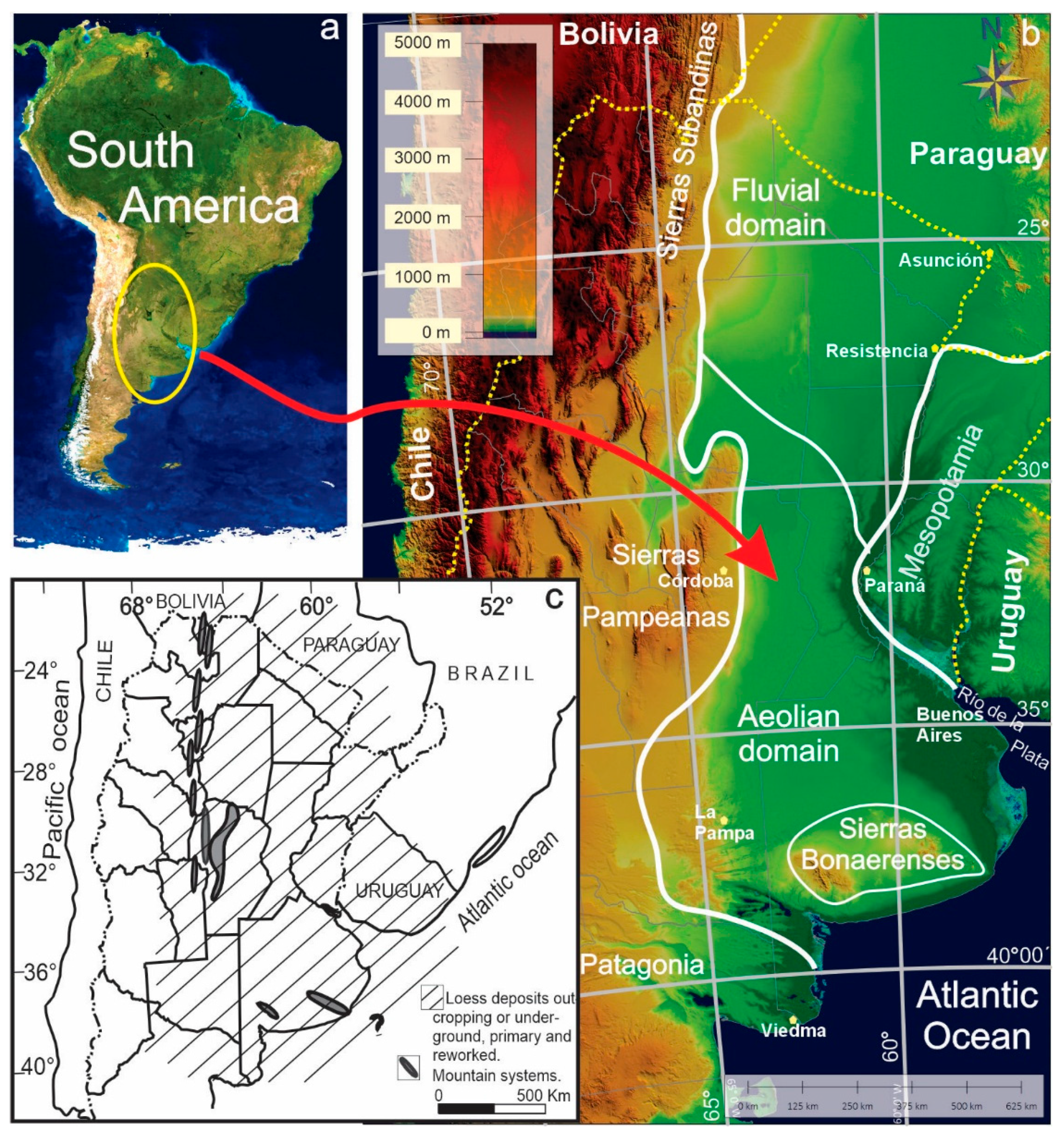
Figure 1. (a) Location in South America. (b) Development of the Chacoparanense Plain [4] and geomorphological domains (modified from [2]). (c) Distribution of loess deposits in the Pampean region (modified from [5]).
Geographies 05 00033 g001
Figure 2. Different exposures of the geological substrate within the study area, illustrating various formation names historically used. In all localities, loess and paleosol levels containing calcium carbonate precipitates are evident. (a) Ayacucho; (b) Necochea; (c) Brandsen; (d) General Acha; (e) Coronel Suárez.
Geographies 05 00033 g002
Figure 3. Distribution of the main aeolian geomorphological units in the southern Pampean Plain. The yellow boundaries delineate areas of dominant morphologies—parabolic, longitudinal, and mixed dune fields—based on interpretation of false-color Landsat composites and field observations. These boundaries are approximate and mark gradual transitions, as some overlap between morphologies is expected. The background is a mosaic of false-color Landsat imagery, which enhances the visibility of dune fields, deflation basins, and loess mantles across the region.
Geographies 05 00033 g003
Figure 4. Shaded terrain model showing furrows and lowland systems north of the Colorado River, within the structural plain of southern Buenos Aires Province. The image highlights a series of elongated depressions and associated shallow lakes and salt flats, aligned predominantly NW–SE. BB: Bahía Blanca City. See legend for feature abbreviations (e.g., ECSF: El Chancho salt flat; CS: Chasicó shallow lake). Elevation is expressed in meters above sea level (m a.s.l.). Elevation data derived from SRTM, provided by the GLCF, University of Maryland.
Geographies 05 00033 g004
Figure 5. Shaded relief map derived from Sentinel-1 SAR data, illustrating the spatial arrangement and morphological characteristics of lowlands, dune corridors, and structural crests in the study area. Major corridors are labeled for reference. Elevation values are expressed in meters above sea level (m a.s.l.).
Geographies 05 00033 g005
Figure 6. Hucal Chico Corridor and crests with circular dissolution depressions (uvalas). Two elongated depressions, oriented E–W, are separated by a threshold corresponding to a remnant of the original plateau, currently undergoing intense erosion. The background image corresponds to a shaded Digital Terrain Model, with satellite imagery insets highlighting contrasting surface patterns. (a) Eastern sector, where depressions are smaller, denser, partially interconnected, and characterized by sparse vegetation cover. (b) Western sector, with larger, isolated depressions separated by broader vegetated areas. Elevation data derived from SRTM, provided by the GLCF, University of Maryland.
Geographies 05 00033 g006
Figure 7. Aeolian dune morphologies identified within the Pampean Sand Sea, illustrated through false-color composite Landsat imagery: (a) longitudinal dunes, (b) parabolic dunes, and (c) transverse dunes, all developed primarily on silty substrates.
Geographies 05 00033 g007
Figure 8. Representative exposures of lunettes belonging to the Laguna Las Barrancas Formation in different geomorphological and sedimentary contexts. (a) Outcrop at Laguna La Tigra showing well-developed stratification between the underlying Laguna Las Barrancas Fm. and the overlying La Postrera Fm., with a person for scale (~5 m exposure). (b) Exposure at Laguna La Boca with a similar stratigraphic configuration, highlighting lateral continuity of units (~3 m). (c) Landscape view of the lunette system at Laguna La Tigra, showing its position relative to the playa lake margin. (d) High vertical exposure (~11 m) of the Laguna Las Barrancas Fm. at the namesake site, with visible sedimentological features and small burrows or bioturbation structures.
Geographies 05 00033 g008
Figure 9. Various exposures of the mantiform loess and its stratigraphic units across different localities. (a) General Conesa; (b) Pila; and (c) Puente de Pascua.
Geographies 05 00033 g009
Figure 10. Edge of the crust layer in a furrow (a), and the peculiar appearance of the crust (b,c).
Geographies 05 00033 g010
Figure 11. Aeolian landforms and inferred wind directions in the study region. The map shows dune types, deflation areas, and furrows shaped by dominant winds from the southwest and west during the Late Quaternary.
Geographies 05 00033 g011
Disclaimer/Publisher’s Note: The statements, opinions and data contained in all publications are solely those of the individual author(s) and contributor(s) and not of MDPI and/or the editor(s). MDPI and/or the editor(s) disclaim responsibility for any injury to people or property resulting from any ideas, methods, instructions or products referred to in the content.