Article

Comparative Analysis of Runoff Diversion Systems on Terraces and Glacis in Semi-Arid Landscapes of Spain and Tunisia

by
Ghaleb Fansa-Saleh
1,*,
Alejandro J. Pérez Cueva
1 and
Emilio Iranzo-García
2
1
Department of Geography, Universitat de València, Avenida Blasco Ibañez 28, 46010 Valencia, Spain
2
Cátedra de Participación Ciudadana y Paisajes Valencianos, Department of Geography, Universitat de València, Avenida Blasco Ibañez 28, 46010 Valencia, Spain
*
Author to whom correspondence should be addressed.
Geographies 2025, 5(3), 32; https://doi.org/10.3390/geographies5030032
Submission received: 24 April 2025 / Revised: 25 June 2025 / Accepted: 9 July 2025 / Published: 10 July 2025

Abstract

This study explores the water harvesting systems of mgouds in southern Tunisia and boqueras in southeastern Spain to understand their adaptation to semi-arid conditions and geomorphic contexts. These systems use ephemeral water through medieval-origin infrastructures to increase the water supply to rainfed crops. The hypothesis is that the diversity of these systems stems from environmental rather than cultural factors. By employing a qualitative–analytical approach, this study compares concentrated runoff diversion systems to investigate the use of boqueras/mgouds in terraces and glacis in the arid and semi-arid areas of Tunisia and the southeastern Iberian Peninsula. The research involved performing detailed geomorphological and climatological analyses and comparing structural complexities and water management strategies across different regions. The results indicate significant variability in system size and complexity. Tunisian mgouds are typically simpler and more individualised, while Spanish boqueras are larger and more complex due to more frequent and intense torrential rainfall. No common patterns were identified between the two regions. This study reveals that both types of systems reflect sophisticated adaptations to manage water scarcity and mitigate the impacts of intense rainfall, with geomorphic and climatic factors playing a decisive role. The primary conclusion is that the design and functionality of these water systems are predominantly influenced by environmental conditions rather than cultural factors. This research provides insights for developing sustainable water management strategies in other semi-arid regions.

1. Introduction

In semi-arid environments, where the landscape is characterised by water limitations, the management of water scarcity has been a historical practice since antiquity. The collection and management of water for human supply and agriculture has formed a water culture that shapes the landscape. Traditional techniques are part of a body of multifunctional knowledge, including water collection, soil retention, protection of vegetation and crops, management institutions, and collective action. Knowledge and techniques refined through experience and time were transmitted from one generation to another [1]. These practices work as a sustainable system that appropriately uses nearby and renewable resources such as rainwater and surface and subsurface runoff.
In the context of climate change, where rainfall is more irregular, water resources will be more limited. However, the consolidation of water resource management institutions, with hydrological policies at a national or regional scale, together with confidence in technical advances and the desire for larger-scale agricultural production, have led to an unsustainable model in the long-term of the collection of fossil waters from underground reservoirs, long-distance inter-basin transfers, the modernization of irrigation systems, and the desalination of seawater [2,3]. This situation explains that in some areas the traditional collection and use systems have stopped being used, which represents a loss in the environmental, technical, landscape, and heritage dimensions.
There are researchers who argue that traditional rainwater and runoff collection practices are a very interesting alternative. They are compatible with historical lifestyles and contribute to increasing water reserves that make human supply and sustainable agriculture possible [4,5,6,7,8]. Among traditional water management techniques, a water harvesting solution consists of diverting all or part of the runoff concentrated in watercourses to farmable geomorphic environments, such as dejection cones, river terraces, or glacis. This involves channelling ‘turbid’ water to increase the water supply to rainfed crops. These systems must be adapted to the characteristics of the environment. For this reason, as well as possessing common elements, they must adopt specific types of solutions and must necessarily have distinct characteristics depending on the local geomorphic environment. The aim here is to examine the specific characteristics of concentrated runoff water harvesting in river terraces and glacis.
The boqueras or mgoud are a form of water harvesting the concentrated runoff in ravines or wadis and consists of diverting all or a portion of the flowing water in periods of heavy rainfall through a dike to be used in crop fields. The main difference between this method and other concentrated runoff water harvesting methods is that the harvesting site is located outside the bed. Capturing the flow can be practised even in the smallest watercourses. Intercepting and diverting this occasional water is of utmost importance in a semi-arid environment: a farmer cannot waste it by letting it run off down the wadi [9,10,11]. The water of the wadis can be diverted with a fixed dike or simply by a wall of stones and sand [12]. Regarding diversion dykes, Morales Gil [13] distinguishes between the following two main types: the transverse type, which intercepts all the water in the watercourse, and the embankment type, which intercepts only part of the watercourse.
To achieve an adequate water velocity in the boqueras (not too fast that it crumbles the dike, nor too slow that it could clog the channels following sedimentation by the turbid waters), farmers usually combine several techniques: an ascending slope in the first section; a decanter-pond; a spillway flow regulation gate; and a lowering of the height of the dike [14]. The use of the flow of the watercourse can be full or partial, except in the case of public utility dikes in which the dike may interrupt the entire bed. Customary law establishes that peat bogs cannot be used to capture the entire flow with the effect that owners located downstream are denied water [15,16].
In the Iberian Peninsula, it has been considered that the technology applied to the use of water is of Arab origin, introduced from the Near East [17]. However, the first written references to the use of floodwater in Spain are in the Fuero Juzgo, and so the technology was in earlier use. The Fuero Juzgo is a translation of the Visigothic Liber Iudiciorum or Book of Judges (7th century), initially promulgated by Recesvinto (654 AD) and later completed. The translation to Romance dates to Fernando III (1241), although it seems that there are earlier versions (in Catalan, Arabic, and even an 11th-century version commissioned by the Asturian monarchy) [18]. Thus, boqueras and mgouds are very ancient techniques applied throughout the Mediterranean before the Arab domination, although the latter increased their diffusion. These techniques probably have an important Roman origin [19], and works are cited in which these techniques are emphasised ([20,21], among others). The first research on water management in North Africa dates to the early- to mid-20th century and was carried out by French researchers ([22,23,24], among others).
The objective of this study is to analyse whether the implementation and form of runoff diversion systems are primarily determined by physical environmental factors, or whether non-environmental factors also play a significant role. Specifically, we investigate which key factors influence the presence and configuration of these systems in different geomorphic contexts. We also examine how the diverted water interacts with the geomorphological environment. In the Tunisian case, we explore the transition from valley-bottom runoff harvesting systems (jessour) to hillside diversion systems (mgoud). Our approach combines original fieldwork with a comparative analysis of previously documented cases.

2. Materials and Methods

2.1. Study Areas

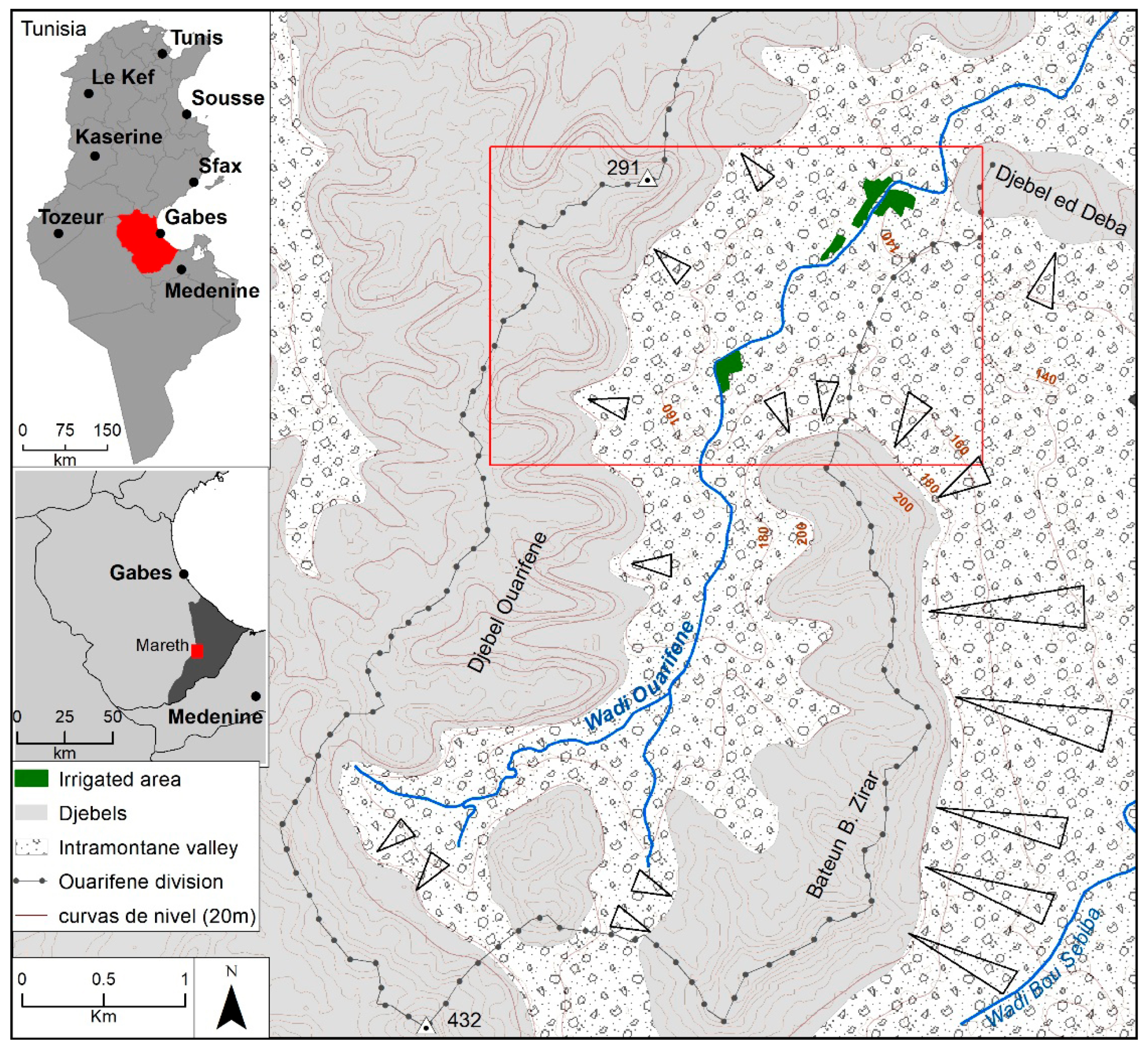
Among the cases studied in Tunisia and southeast Spain, comparable examples were selected, but at the same time a wide range of unique conditions were present (Figure 1). In Tunisia, the strategy was to locate cases of traditional mgouds from local informants, visit them, and carry out fieldwork to decide on a selection that is representative of different environmental contexts. In southeast Spain, examples were selected that met the criteria of diversity and comparability based on existing studies or quotations [14,25,26].
In the case of Tunisia, examples of mgouds were chosen in three sectors between Gabes and Medenine (in the wadis of El Djedari; El Gutar; and Ahimeur) in the Benikhdech delegation of the governorate of Medenine, and in the Wadi Ouarifene in the Mareth delegation of the governorate of Gabes. During the fieldwork, several mgouds were located and mapped in detail in each location: six in Bhira, eight in Ahimeur, and six in Ouarifene. This is a sample of the considerable number of remaining mgouds.
For southeast Spain, we chose representative boquera systems from several geomorphic contexts: terraces, abandoned meanders, and glacis. In all cases, maps of all or part of the elements of the system were available. This documentary and bibliographic base [14,25,26] were essential for the analysis of the geomorphic conditioning factors of the systems because all are now abandoned and many of their constituent elements have been lost.
In this study we considered several key factors in the analysis of traditional water harvesting techniques. These include the geomorphological context, as well as the climatic and hydrological conditions that influence the design, effectiveness, and spatial distribution of these systems. These factors were selected as they are fundamental to understanding the environmental rationale behind the development and use of traditional water harvesting practices.

2.2. Environmental Factors

These conditioning factors of the physical environment for the application of these techniques are principally topographical, geological, climatic, and geomorphological. They operate within a wide range of possibilities, but with extremes in which these techniques cannot be applied or are of no interest.
The geological factor, in principle, has little direct conditioning or limiting effect, except for the lithologies. Loamy and clayey lithologies, or Quaternary alluvium, generally present the greatest number of cases for several reasons: a greater generation of runoff in the basin; the ease of excavation of the boqueras and the drilling of tunnels (alcavons), if necessary; a greater possibility of generating glacis; and surfaces that are suitable for irrigation. However, there are cases of canals carved into hard rock, and such lithologies also sometimes offer advantages (including the ease of finding blocks for diversion dykes and better anchorage for abutments) [27].
The topographical factor does not usually act as a limiting factor either, as it allows these systems to be designed in a wide range of contexts [27,28]. Examples can be observed in ravine valleys with an abrupt relief and in flat topographies, although it is evident that the latter are clearly more favourable because they facilitate the layout of the canal, ensure that a lack of irrigable areas is not a limiting factor, and bring the water capture point closer to the irrigated area.
The geomorphological factor, closely linked to the previous one, acts in the same way. It is not a limiting factor since irrigated areas with peat can be observed even on hillsides [29]. There are three geomorphic environments in which these systems tend to be installed as they are suitable areas for cultivation: dejection cones, fluvial terraces, and glacis. The river network is a geomorphological element that could be an important conditioning factor, both in the irrigated area and, above all, in the channel from which the peat is taken [30,31]. Our hypothesis is that this factor does not act as a limiting factor either, although it notably conditions the magnitude of the water dikes and the length of the channel between the water diversion and the irrigated area.
The climatic factor apparently works the other way round as it sets a very specific limit for the appearance of these techniques, although it is not, strictly speaking, a limiting factor. These techniques are characteristic of semi-arid areas, with rainfall normally between 150 and 400 mm/year, and especially between 200 and 350 mm/year. Rainfall greater than these amounts makes such techniques unnecessary, and it is very difficult for these techniques to be efficient for amounts below 200 mm. For the lower limit, the key climatic element is rainfall intensity. For a boquera/mgoud to be efficient, the rainfall needs to not only be torrential and capable of producing runoff in dry riverbeds but also occur several times a year on average. In Tunisia, this normally implies an average total annual rainfall of at least around 150–200 mm/year, as can be seen by comparing the location of these systems with the rainfall map [32].
Finally, another factor to consider in the physical environment of the study areas is the hydrological factor. The minimum requirement is that the characteristics of the hydrographical system and its size can generate floods of a minimum magnitude. A minimum, but not a maximum, limit can be observed in systems of boqueras in large dejection river cones with extensive basins (Tiata/Guadalentin, Belkhir) [33]. In the case of the minimum hydrological limit, behaviour is conditioned by many factors—the lithology of the basin, its extension, the structure of the network, the slopes, and the intensity of rainfall—as well as by competition with other systems, especially when the cultivation systems in valley bottoms (jessour) are already incapable of assimilating and controlling the concentrated runoff [26,34].

2.3. Method and Data Sources

The research method is qualitative–analytical and is based on the comparative study of concentrated runoff diversion systems on terraces and glacis in arid and semi-arid areas. First, case studies with similar environmental characteristics were selected. According to [35], case selection is a key step in this type of study as it requires designing analytical units of comparison, which means creating comparison criteria that address variables within the cases.
To understand the spatial distribution of the mgoud and boquera systems, and their coexistence with other systems of runoff exploitation, a photointerpretation of current satellite images was used in the case of Tunisia and aerial photographs from 1956 for Spain (with these irrigation systems having since been abandoned in Spain). The processing of all the spatial information and the preparation of the detailed cartography were carried out with ArcGIS 10.8 software.
Field work has allowed us to verify the existence of the systems, as well as to directly observe the elements of their design, their state of conservation, their current functionality, and their degree of adaptation to the environment. In addition, a Digital Terrain Model was employed to generate contour lines and delineate the hydrographic network in both the Tunisian and Spanish contexts. For the Tunisian case studies, the NASADEM Digital Terrain Model with a spatial resolution of 30 metres was used, offering notable improvements over the earlier SRTM data. In the case of Spain, a Digital Terrain Model derived from the First Coverage LiDAR point cloud was utilised with a spatial resolution of 5 metres. This information was necessary to understand the hydrological logic of the traditional runoff catchment systems and their integration into the landscape, as well as to complement the spatial analysis carried out by photointerpretation and thematic mapping. The climate data used in this study came from the Climate Forecast System Reanalysis (CFSR) dataset; these data are of a modelled nature and are distributed with a daily temporal resolution.

3. Results

3.1. Mgouds of Tunisia

The chosen areas are the foothills of the Dahar in the Jeffara plain. Two are located in foothills, Bhira at the start and Ahimeur a little further down. The mgoud of Ouarifene is in a riverbed facing the mountains and just before the foothills.
Most of the cases analysed are very small systems, which draw off a small portion of the flow and lead the water to cultivated plots with channels just a few metres long. The interest in the sample analysed and the locations chosen is because they enable us to understand the precise role of this system in coexistence with others, such as the tabias in glacis and the jessour.

3.1.1. Bhira and Ahimeur (Benikhdech, Medenine)

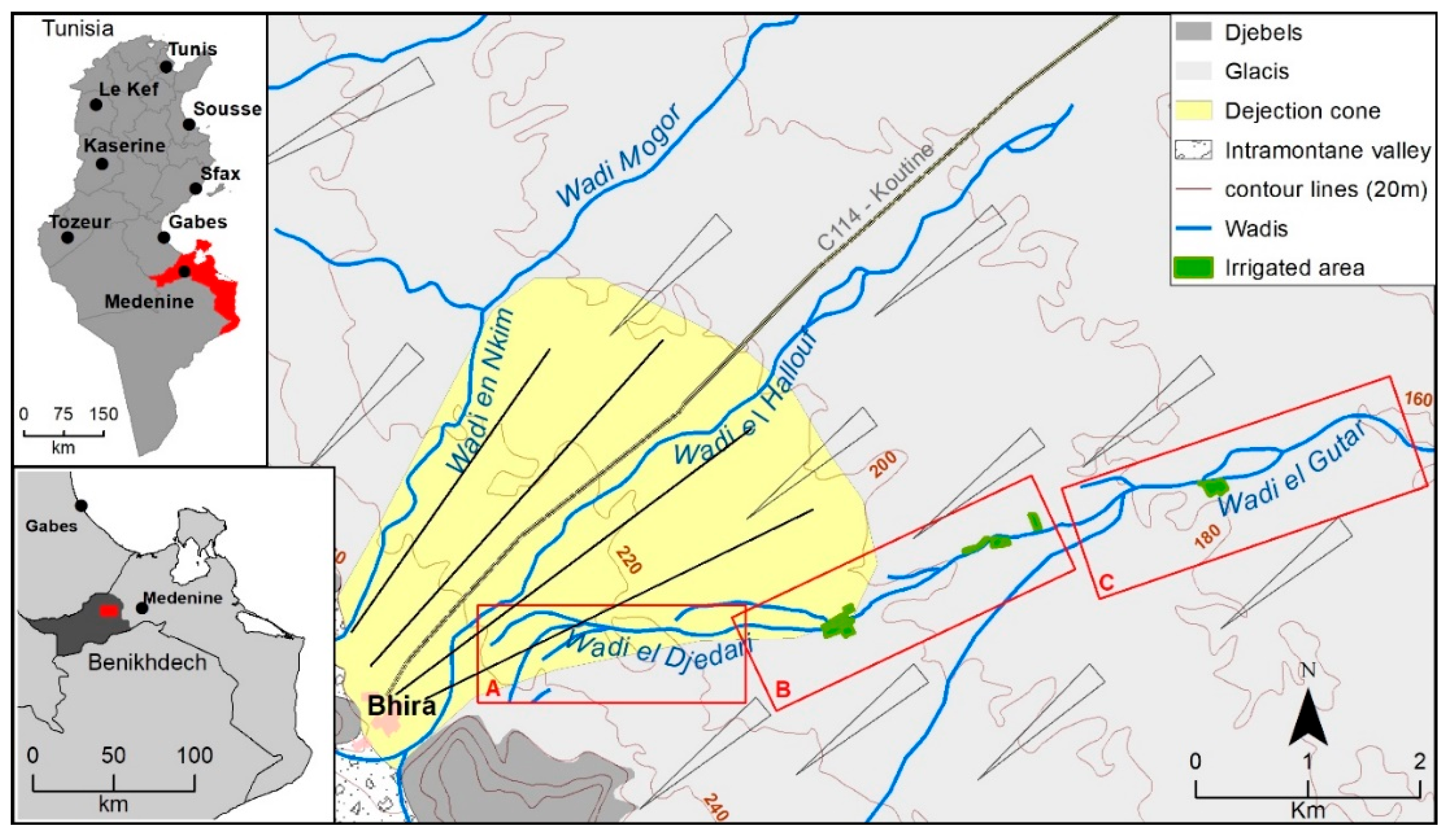
The mgoud systems of Bhira are in the foothills of the Mogor mountains in the vicinity of Bhira. The entire piedmont of the Medenine arc is a vast Pleistocene erosion glacis with more recent ‘replacement’ glacis in the lower part (by sediment redistribution) and with a floor of Pleistocene dejection cones at the foot of the mountains [36]. The geomorphic context of the Bhira systems corresponds exactly to this scheme as the piedmont starts with a medium-sized dejection cone built by the Wadi el Hallouf, with the contribution of other modest channels, such as the Wadi en Nkim, but it soon gives way to a vast undulating plain with the morphology of an erosive glacis (Figure 2).
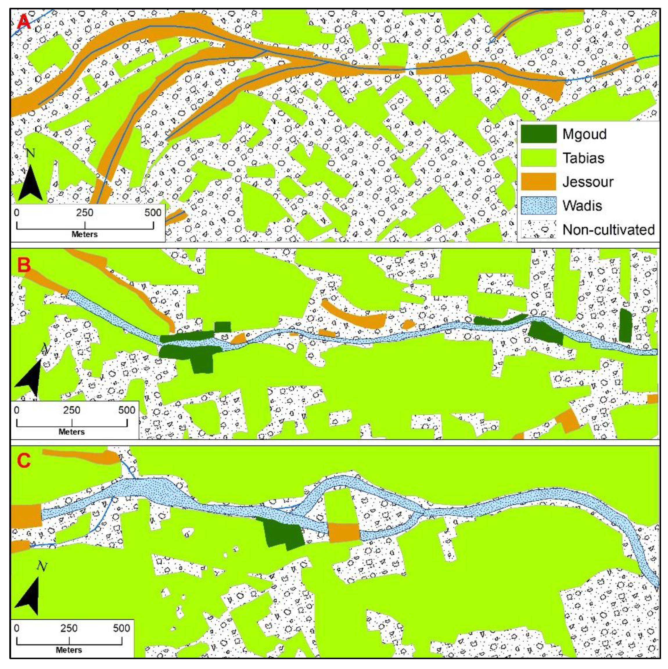
The systems studied are located in the Wadi El Djedari and continue in the Wadi El Gutar, starting at its confluence. The Wadi El Djedari starts from the apex zone of the Bhira dejection cone and was probably a paleochannel of the radial network of the cone when it was forming. Its headwaters are non-existent as it begins as a watercourse. The Wadi El Gutar, on the other hand, has a small headwater on the mountain front (which it scarcely penetrates) and, therefore, is a little more important. The sum of both increases the importance of the riverbed where the mgoud systems are found. The land uses of three sections of this sector, which include all the mgouds located in the area, are mapped. There are no systems at the headwaters of the river in sector A (Figure 3).
A watercourse is occupied by continuous jessour systems, with foothill tabias in the flat interfluves between watercourses. Almost all the mgouds are located in the central sector (B) before the confluence of the Wadi el Djedari and the Wadi el Gutar, where a riverbed has already been created with a small continuous channel that allows water to be easily diverted. These are very small systems (Table 1), sometimes with only one cultivation plot and few waterfalls between plots. Finally, in sector C, and in the rest of the channel downstream, there are a smaller number of mgoud plots. In this section, the bed is wider and the jessours have completely disappeared.
There is a coexistence between three or four types of water harvesting systems, with each occupying its most suitable topographic and hydrological environment: tabias on piedmont surfaces (dejection cone or glacis) with little gradient; jessours where some runoff can be collected in the smaller watercourses; and mgouds when the concentrated runoff reaches a greater volume and can no longer be controlled so easily. The transition from jessour to mgoud is gradual (with stretches where jessours and the riverbed alternate) but clear (the jessours disappear completely from one point onwards).
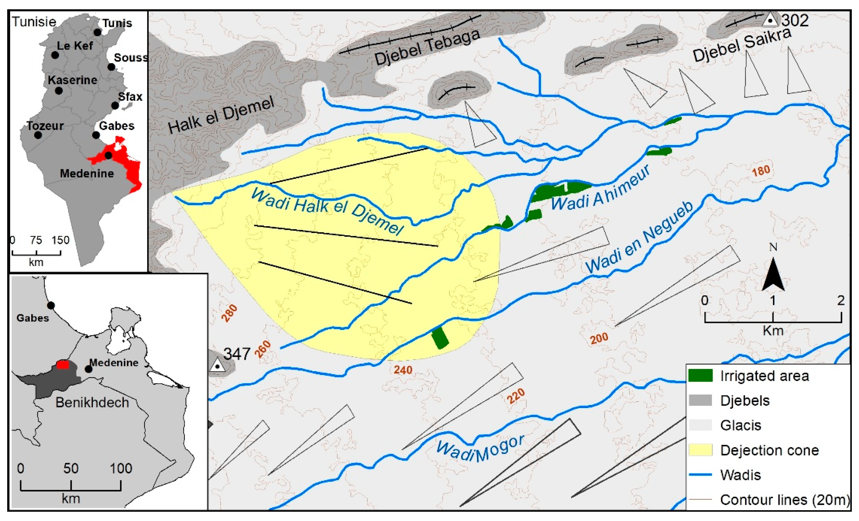
The mgoud sector of the Wadi Ahimeur (Figure 4) has very similar characteristics to those of Bhira, in terms of both the characteristics of the systems and the spatial structure. This is because their geomorphic and hydrological contexts are basically the same.
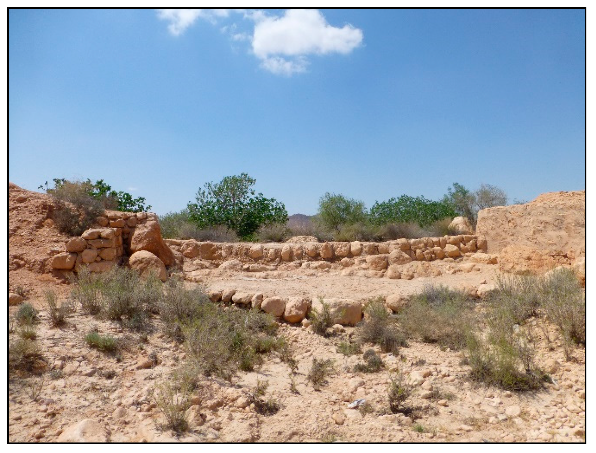
The mgouds in these two sectors are small (Table 1). They usually irrigate a few plots (between one and seven) and are fully active. As they are small systems with occasionally large runoff inputs, they require reinforced drains leading to the main channel for the surplus (Figure 5).
The result is that the mgouds are almost exclusively restricted to the small northern streams and, within them, to their middle and lower reaches. It is the same type of spatial structure as that described in Bhira, with jessour in the upper reaches, where runoff is controlled, and mgoud in the lower reaches, where the risk of erosion in the jessour is notable and runoff can be harnessed with small intakes.

3.1.2. Ouarifene (Mareth, Gabes)

The Ouarifene mgoud sector is located to the north of the Tebaga threshold, about 15 km southwest of Mareth (Figure 6). This sector is part of a group of small djebels and massifs located in front of the Dahar Mountain front (known locally as the Matmata Mountains). It is a valley running south–north, between the first djebels of the mountain front (djebel Ouarifene, djebel ed Deba, djebel Bateun ben Zirar).
The morphology of this intramontane sector differs somewhat from the previous sectors of Bhira and Ahimeur. It is a valley flanked by djebels of Upper Cretaceous carbonate materials (the Cenomanian–Turonian El Guettar dolomites). The interior is made of Neogene materials, covered by the Quaternary. There is a rapid transition between the mountain slopes and the main riverbed in which small erosion–accumulation glacis develop, with watercourses running down from the mountains.
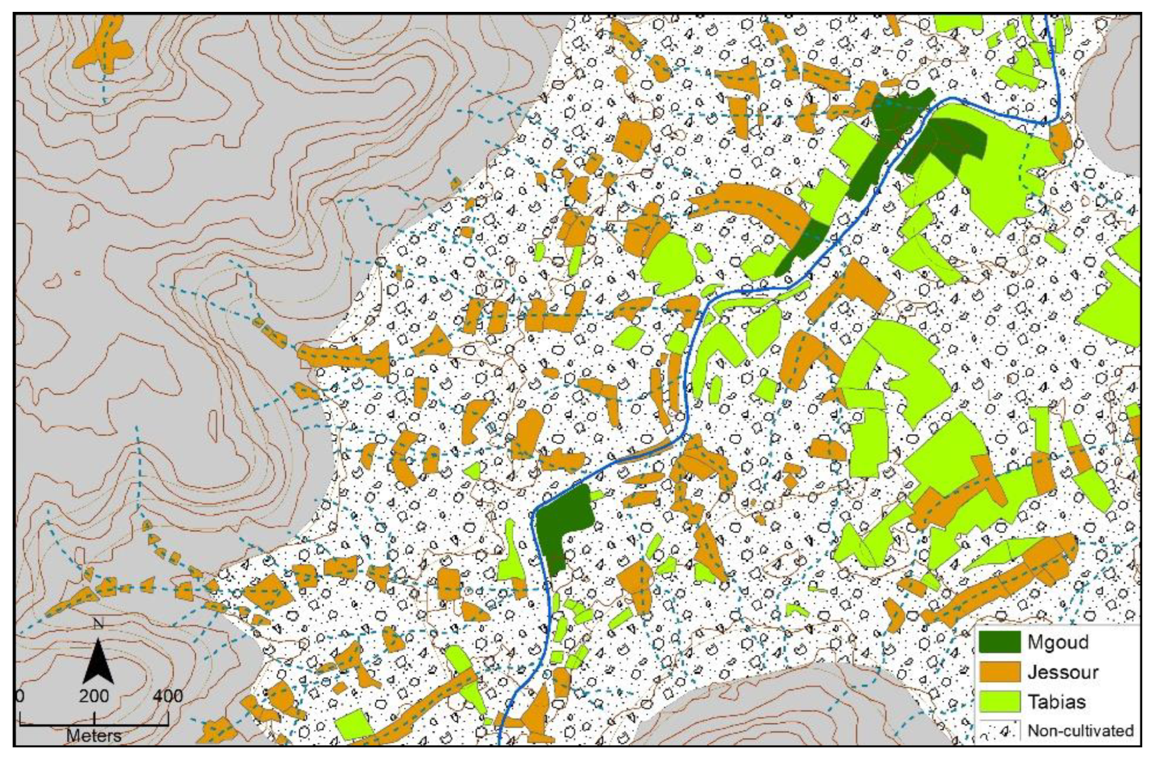
The land uses in this sector also combine, as in the two previous cases, the jessour, the tabias on slopes, the glacis, and the mgoud, although the proportions and their spatial distribution change. In the middle of the headwaters, the jessours are predominant, given that the network of watercourses and river courses is quite dense and the runoff they concentrate is scarce. The tabias are reduced to a few somewhat flatter spaces in the interfluves and lower parts of the small glacis. The mgouds are non-existent in this high sector.
In the middle part the distribution pattern described above continues, with an increase in the number of tabias as the glacis are a little wider, but very few mgouds. Stretches of the main course and larger tributaries with uncultivated meadows can be seen in this middle sector of the valley.
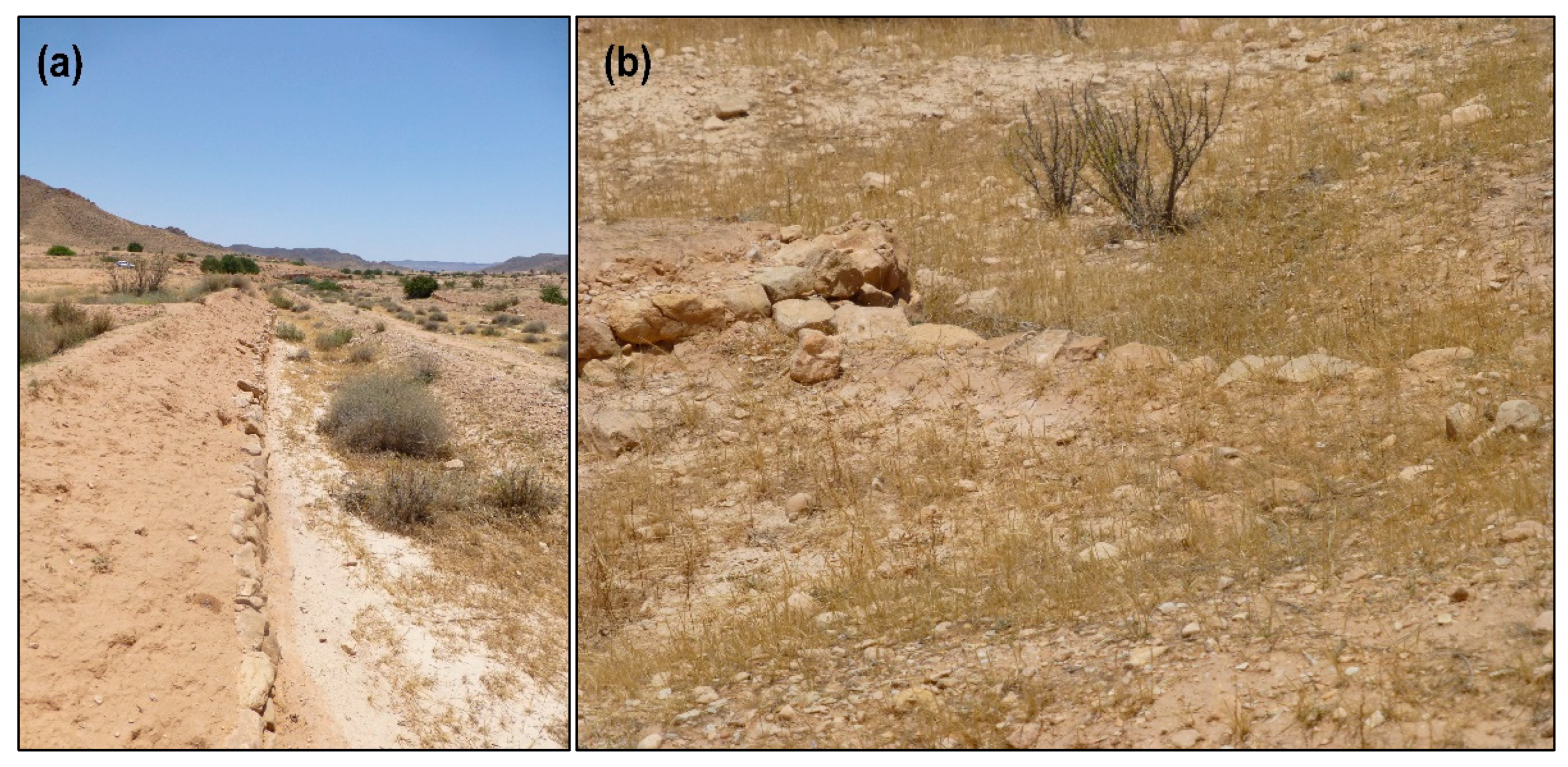
The lower sector of the Ouarifene valley was mapped, and many mgouds can be seen. The jessours are restricted to the watercourses of the small tributaries coming down from the mountains and are no longer present in the main course. The tabias become more common as the glacis expand (Figure 7). The six mgouds in the Ouarifene sector, as in the Bhira and Ahimeur sectors, are small (Table 1 and Figure 8), irrigate only a few plots (between one and four), and remain active.

3.1.3. Climatic and Hydrological Context

The main key to the presence of mgoud systems in this sector of southern Tunisia, between Gafsa and Medenine, lies in the generation of sufficient runoff such that the jessour systems are no longer able to manage. Statistical modelling and mapping of extreme daily rainfall in Tunisia helps us understand the context of heavy rainfall: apart from its maxima to the north of the Atlas, the spatial structure of heavy rainfall has a very clear east–west gradient [37]. The decadal maximum rainfall reaches values close to 90 mm in Djerba and less than 40 mm in the desert interior. The values increase due to the orographic effect of the Matmata mountains, and there is an increase in torrential rainfall in the Gafsa sector in the interior. The area studied here has somewhat lower values than Gafsa, between 70 and 80 mm/day, but its location near the coast and at the foot of the mountains is a favourable factor.
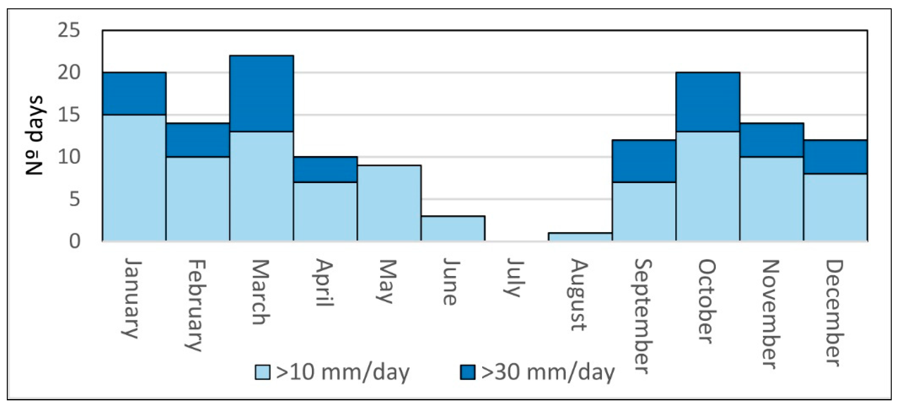
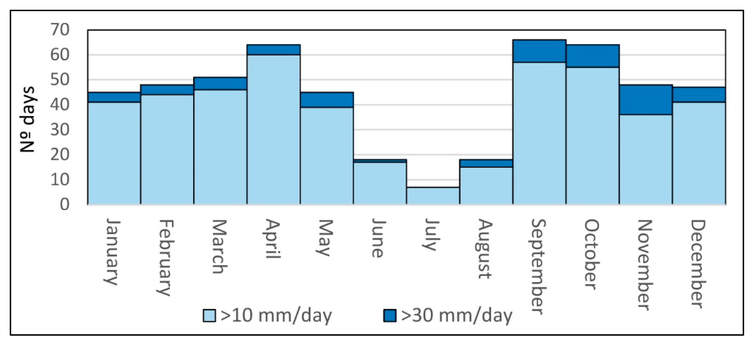
An approximation of daily heavy rainfall totals of moderate values, with two thresholds, 30 and 10 mm/day, has been made from daily rainfall data from Matmata (Figure 9). Values greater than 30 mm are too infrequent for the mgoud systems to function. The number of days above 10 mm reaches annual average values of 3.9 days/year (137 cases in 35 years). This is not the optimum frequency, but it is close to the minimum threshold required. If the analysis could have been made with frequencies of minute intensities, the results would probably be more convincing and closer to the reality of the operation of these water and mgoud systems.

3.2. Boqueras in Southeastern Spain

3.2.1. Boqueras of the Masía De La Tosca (Xixona, Alicante)

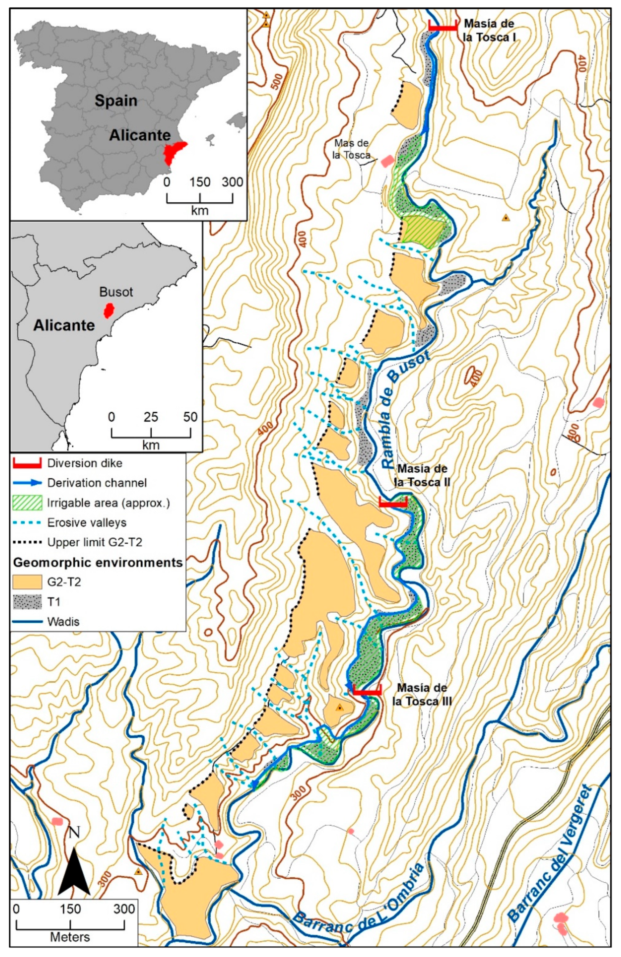
This is a group of three systems of caves (Tosca I, Tosca II, and Tosca III) in the municipality of Xixona, some 6–7 km to the southeast of the town. All the systems are on the right bank of the Rambla de Busot, a river that flows into the Riu Montnegre near Mutxamel (Figure 10).
In the section of the three boquera systems, the Rambla de Busot flows through a narrow valley. The flanking mountains are higher than 400–500 m, while the riverbed runs between 370 m at the start of Tosca I and 270 m at the end of Tosca III. These are Upper Cretaceous limestone mountains. The valley is carved out of sandy marls and limestones from the Lower Cretaceous. It is an unusual geological context in the Alicante Pre-Baetic, where the marls on which the valleys develop are usually Neogene. This is a Cretaceous anticline with a core of softer Aptian–Albian materials.
On both banks, especially on the right, glacis-terrace levels have developed on these soft materials (probably G2–T2, Middle Pleistocene, as they make up the dominant regional morphogenetic level). These levels overhang the current riverbed by 30 m, as the current fluvial network has deeply dissected them and is very embedded. The glacis have also been dissected by the ravines coming down from the mountainous axes flanking the valley. Below this morphogenetic level, and some 3–4 m above the current bed, a terrace level can be seen with a fair degree of continuity which, due to its morphology, can probably be interpreted as dating from the Upper Pleistocene–Holocene (T1).
The boquera systems exclusively use these low terraces as a peat irrigation area. The possibility of raising the water further would entail much longer conduction channels and, in addition, the difficulty of having to cross the numerous lateral ravines that dissect G2–T2 with aqueducts. In the case of Tosca I, the headwater system, it is necessary to raise the water and conduct it on a 325 m long canal to the usage area. In the other two systems the water can be used earlier, but they also have long conduction canals (about 750 m for Tosca II and 540 m for Tosca III) and a difficult route.

3.2.2. Boqueras of La Revuelta (Agost, Alicante)

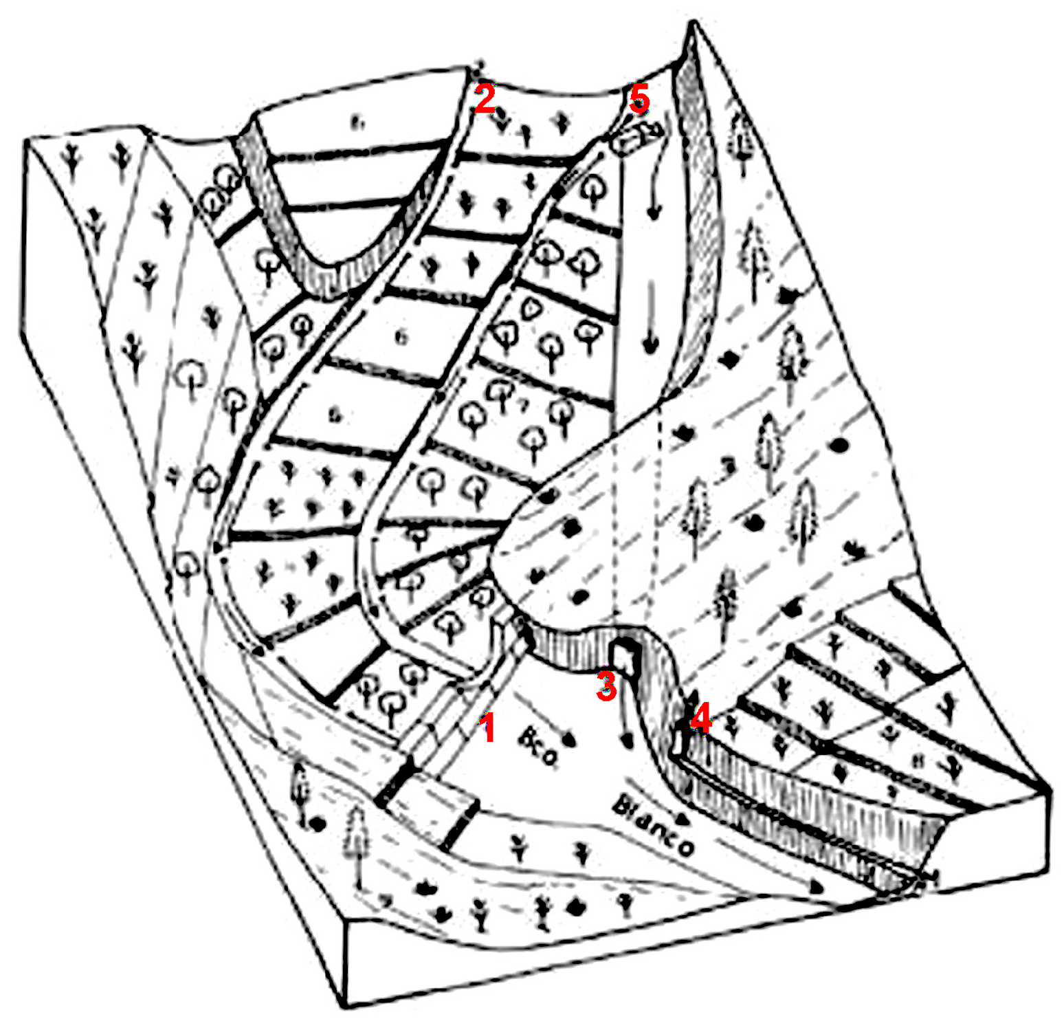
These systems are very close to Agost, about 1.5 km north of the town on the right bank of Blanc ravine. They are two systems of pools that follow an abandoned meander in the middle and on one side. Their location is shown with a description and three-dimensional sketch [25] (Figure 11). Although these systems have partially disappeared, their relationship with the geomorphic context was analysed.
The Blanc ravine is one of the tributary basins of the Rambla de les Ovelles. The sector analysed, near Agost, is in the middle part of the basin and has a catchment area of approximately 15 km2.
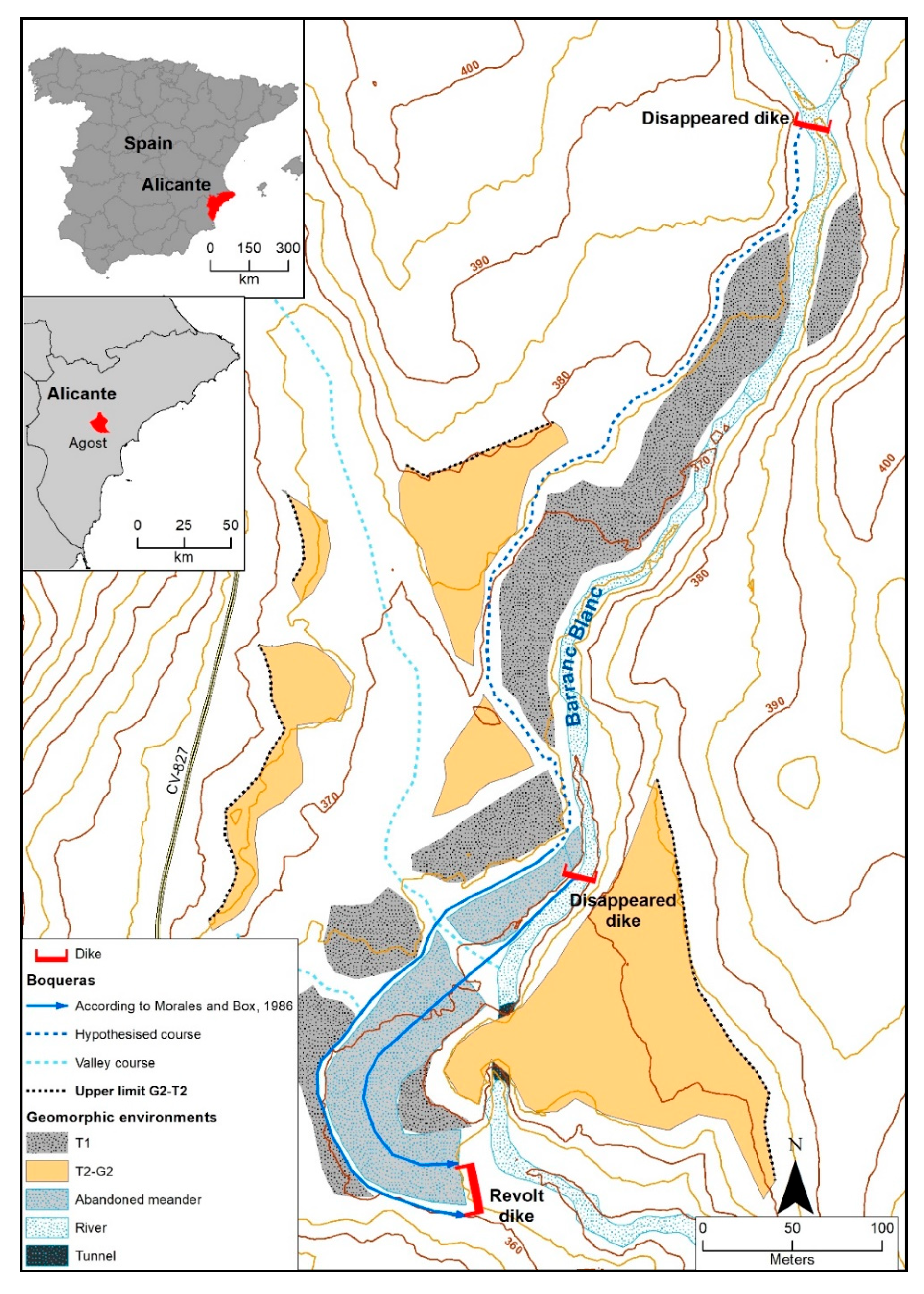
The two systems of boqueras are related to an abandoned meander on the right bank of the ravine near Casa de la Revuelta. In a morphogenetic sequence, the meander would correspond to level T0 (flood terrace) of the set of Quaternary morphogenetic levels seen in the area (Figure 12). Above it, and on other sides of the ravine, the remains of the low terrace (T1) can be seen, with a morphology and at a height similar to those observed in La Tosca. A characteristic of these terraces is that they do not pass laterally into glacis, but only into valleys which erode the dominant morphogenetic level. Above this T1 terrace level, the remains of the G2–T2 Pleistocene level and other older ones, which have not been considered here, are recognisable. This last morphogenetic level is like that observed in other Valencian basins, such as the Turia [39,40], Palancia [40,41], or Maestrazgo [42].
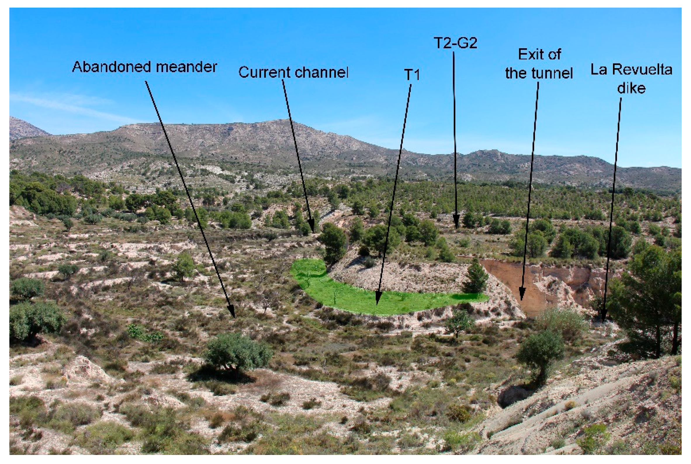
The abandoned meander has a unique origin, as the capture process is through an underground channel (Figure 11, Figure 12 and Figure 13). Neither the mechanism that generates the capture nor its timing are clear. It is suggested as a hypothesis that the capture takes advantage of the weakness of an old water gallery [43], although it could also be a piping process.
The relationship between the nozzles and the accumulation of sediment from the Revuelta dike implies that (i) the capture occurs after the accumulation of sediment upstream of the dike; (ii) the nozzle in the centre of the meander is established after or simultaneously with the capture process (perhaps the lateral one is older); (iii) the fluvial incision in recent years has been very intense, leaving the nozzle systems ‘hanging’ and the intake dike destroyed (Figure 14).
The western boquera has a channel with a total length of about 820 m that could irrigate the lower T1 terraces at the beginning, and the abandoned (T0) meander at the end. The eastern nozzle, about 250 m long, is inside the meander and could only irrigate level T0. One conclusion that can be drawn from the analysis of this sector is that as well as an adaptation of the system to the physical environment, there has also been a modelling of this environment: the underground channel lateralises the riverbed and is a key element in reducing the risk of erosion.

3.2.3. Other Boqueras

Two more sectors of concentrated runoff are analysed below, in which the most significant elements are simply described.
A.
El Salt or Fontanars de Palomarets
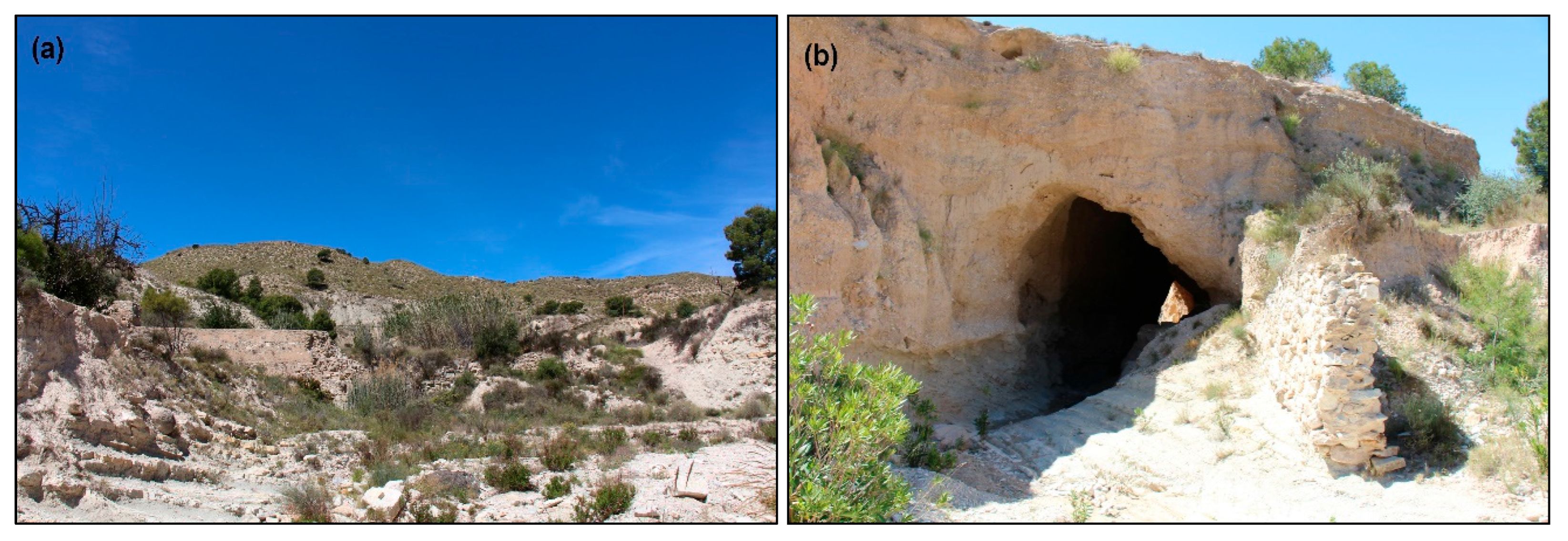
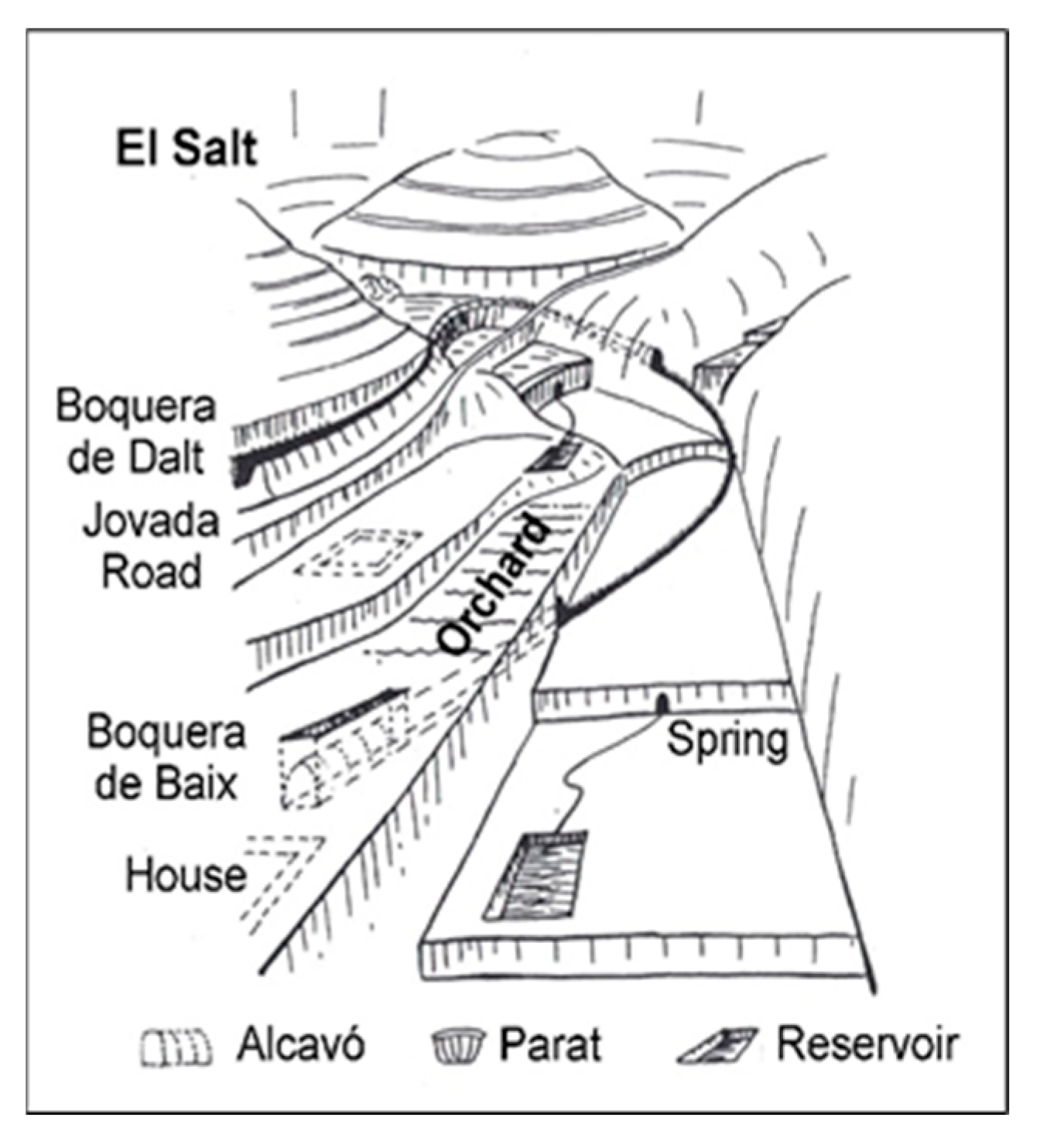
This sector has been selected because of a three-dimensional sketch published [26] on the traditional hydraulic works in Petrer (Figure 15). Two systems of wells emerge from a parat (a large dike or ditch that retains water and sediment, Figure 16a) at the foot of the Salt.
The right (western) boquera is located on the glacis at the foot of Les Penyes del Senyor, a small mountain range to the south of Maigmó. It is probably a degraded morphogenetic level G2–T2. The water is channelled through a channel (Figure 16b) and spilled over the glacis itself. The boquera on the left (the eastern one) takes the water from the same parat and, after passing through several tunnels (alcavons), distributes its water over the small terraces and the valley of the ravine itself, embedded in the glacis.
The upstream basin of the ravine is small (about 0.9 km2) and is carved out of Eocene limestones and sandstones, as well as loamy limestones and marls from the Senonian (above El Salt). The glacis on which one of the boqueras is located has developed at the expense of the erosion of the Albian clays and sands (whose discharges from its multilayer aquifer supply springs in the Els Fontanars area).
In these systems, we would like to point out that some parats can function as both dike and intake sites. In comparative terms, they would have the function of both a jessour and a dike at the beginning of the mgoud. They have the advantage of being considerably raised, which facilitates a better use of the scarce cultivable geomorphic elements (terraces and lower parts of glacis). It should also be noted that, once the water has been collected, the conduction elements can be long, sophisticated, and laborious. These are large-scale designs.
B.
Fontcalent dike system
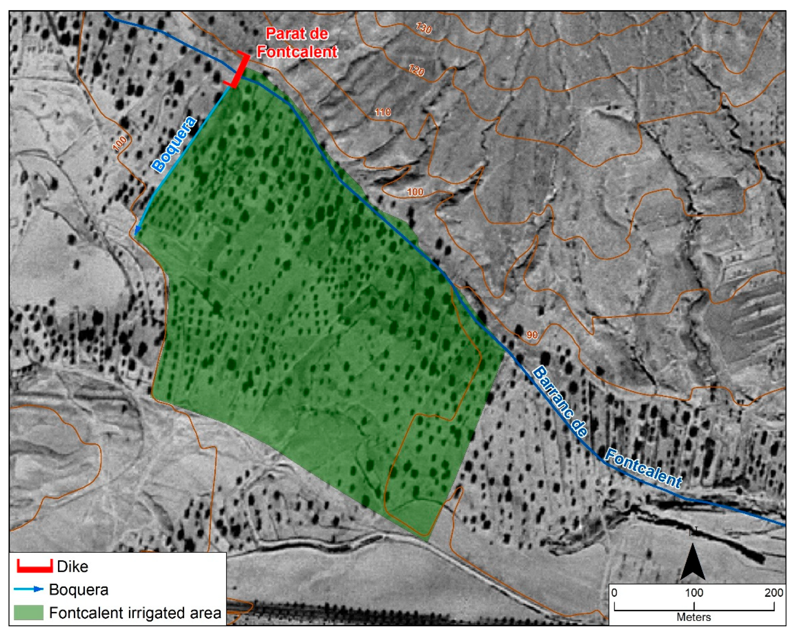
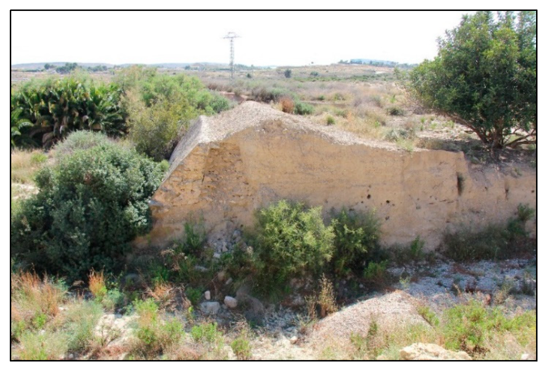
This system is in the Alicante district of El Rebolledo, in the Fontcalent ravine, at the foot of the sierra of the same name. This is an area in which the erosion–accumulation glacis are beginning to open widely, and the mountain ranges are already isolated manifestations of the relief. The fluvial courses are now wadis, as they no longer run embedded in the relief (as in all the cases studied so far in this section, including El Salt). This fact is normally accompanied by a lower gradient between the riverbed and the lateral plains. Even so, it is frequent, and this is the case here, that the water is taken from a large parat. This is due, in part, to the fact that the systems of boquera used to coexist with systems of terraced valley bottoms, especially in the smaller wadis. In the aerial image of the ‘American flight’ (20 October 1956), the bed of the wadi was embanked (Figure 17) and the parat of the water intake of this system contributed to this. This contrasts with the present-day image (Figure 18), which shows that the river network is already embanked.
This example is taken from [14], which maps the entire system (dike and spillway area). According to this author, ‘in reality, there is no diversion dike. The parat, by filling the riverbed, allows the formation of cultivation terraces along the entire alluvial width of the wadi. In this way its waters are laminated and channelled with secondary nozzles…’.
The following two main ideas or features of this system should be highlighted: It is another example of a system that originates in a parat. Its main function is to accumulate sediment and create arable land. This is another manifestation of the intense degradation caused by the neglect or abandonment of these systems, given the fragility imposed by such torrential rains (Figure 18).

3.2.4. Climatic and Hydrological Context

All the sectors analysed are in the central-southern sector of the province of Alicante. This is a notably dry sector of the province as it is within the pluviometric shadow of the Betic mountain ranges in the north of Alicante. The average annual rainfall is between 300 mm and 400 mm, and the monthly distribution of precipitation shows an intense summer dry period, lasting 3–5 months, and heavy seasonal rainfall in autumn. In general, October is the wettest month for all observatories, but especially for those near the coast [44].
The torrential rainfall in this sector of the province of Alicante is not as great as in the north of the province. However, even so, this torrential rainfall is clearly greater than that seen in the Tunisian sectors studied in the previous section. The maximum daily rainfall expected with a 2-year recurrence period is between 50 and 60 mm, and that expected with a 10-year recurrence period is between 100 and 120 mm [45]. In the case of the south-Tunisian sector studied, the probable maximum daily rainfall with a 10-year recurrence is between 70 and 80 mm.
To better compare the conditions of rainfall intensity capable of making these systems work, we have also analysed the frequency of days per year with rainfall above 10 and 30 mm, with the same data source as used in Matmata [38]. The analysis has been made with data from a point near Agost, as it is the most representative of the entire area of the studied wells. The results also clearly show an increase in the number of days (Figure 19). The frequencies of days greater than 10 mm reach mean annual values of 14.9 days/year (521 cases in 35 years). This is three times the frequency seen in Tunisia. These differences are even greater if we analyse the intense days above 30 mm (63 days for the whole period in Spain and 12 in Tunisia).
Another difference between this sector and the one studied in Tunisia is the capacity to generate usable runoff. This is also an intuitive analysis, given the lack of gauging data in the small basins where the systems are located, as well as the lack of a flood register. We believe that the runoff thresholds in these examples from southeast Spain are clearly higher, due to the fundamentally calcareous nature of the river basins. These thresholds can be reached with the minimum frequency required for the functional profitability of a system of waterholes.
Some values taken from studies that have analysed the rainfall–flow conversion in Alicante can help to contextualise the question of minimum runoff thresholds in the area. In the Rambla de les Ovelles, thresholds of intensities of more than 50 mm/h are suggested for flooding to occur in the city of Alicante [46]. In [47], a more precise definition for intensities is given, between 40 and 55 mm/h for more than 10–15 min (about 10 mm). With a different methodology, values of 35–40 mm/day are suggested, without specifying intensities, for the Riu Montnegre basin [48]. We understand that these data are consistent, since, given the genetic characteristics of precipitation in the south of Alicante, daily rainfall values of around 35–40 mm usually imply the minute intensities suggested in previous works.

4. Discussion

The analysis conducted on traditional concentrated flow harvesting systems in the Spanish Levant and Tunisia confirms a series of patterns already identified in the literature, whilst also revealing certain nuances that help refine the interpretation of these systems.
First, the great diversity in the forms and functions of the systems becomes evident—as well as in their scale, ranging from large boquerones [33] to small intakes for single plots. This observation aligns with the findings of Beckers et al. [7] and Roose [27], who highlight variability and local specificity as characteristic features of traditional water management systems across semi-arid Mediterranean environments.
In particular, the results underscore the relevance of environmental factors, especially geomorphology and climate, in shaping these solutions. The role of relief in accelerating and intensifying runoff, and the need for high-intensity yet sufficiently frequent rainfall events, echo the conclusions drawn in studies carried out in southern Tunisia [49,50] and southeast Spain [30]. As the cases considered show, these systems are, above all, environmental strategies—functional responses to semi-arid conditions where rainfall is both scarce and irregular. In this sense, the work of Roose [31] also supports the idea of water harvesting as a mechanism of environmental adaptation.
Such adaptation often entails a rapid spatial transition between different types of systems, as observed, for instance, in southern Tunisia, where jessour structures in upland areas give way to mgoud systems in adjacent lower zones. This kind of shift illustrates the responsiveness of these practices to micro-variations in topography and hydrological behaviour.
Moreover, while a tendency toward simpler and more individual systems can be observed in the Tunisian context, this pattern seems to correspond less to cultural differences and more to environmental constraints. The greater geomorphological complexity and intensity of torrential events in the Spanish Levant, for example, may necessitate more robust and collective infrastructures, offering a plausible environmental explanation that complements, and in some cases may outweigh, sociocultural interpretations.
However, unlike much of the referenced literature, the present text places less emphasis on sociocultural and institutional factors. While the presence of irrigation ordinances is acknowledged in cases of collective use, it is the physical context (relief, rainfall, and geomorphological setting) that is consistently presented as the main explanatory framework. This contrasts with the approach of authors such as Beckers et al. [7] and Roose [27], who stress the importance of cultural traditions and social organisation in the development, use, and persistence of these systems.
In this regard, the reading proposed here tends toward a technical and functional interpretation of the systems, focused on their capacity to manage water under difficult environmental conditions. Meanwhile, other studies place these same systems within broader socio-institutional frameworks, viewing them not only as hydraulic constructions but as integrated land and water management strategies [31], shaped by the communities who built and maintained them.

5. Conclusions

From the results, it can be concluded that there are no differences between the morphological and functional characteristics of the mgoud systems in the three sectors analysed in Tunisia. There are also no differences in the spatial structure of their location, despite being in different geological and geomorphic environments. A combination of the mgoud system with other water harvesting systems characteristic of semi-arid Tunisia can also be seen. The key to their presence and use lies in runoff; if it can be controlled, a jessour is preferred, and when the risk to these systems is too great then the water is left to flow freely, but a mgoud is used to make the most of it. However, mgouds have constraints and cannot always be used in cases of excessively abundant or violent runoff, a river network that is too confined, or when there is a lack of suitable space for cultivation.
In the cases analysed in Spain, we can see that these are systems in places with difficult geomorphic conditions, whose design has sought to increase the quality and extension of the irrigated land (low river terraces). A key to understanding their construction lies in the great effort made to overcome the difficulty in raising the water and conveying it to an irrigable area. This is achieved with large-scale catchment dikes in watercourses with flood flows of a suitable size and frequency.
Both the Tunisian mgoud systems and the Spanish boqueras are characterised by a close integration with the physical environment, the use of topography, and a water collection and distribution logic based on gravity. Their minimal dependence on external energy and relatively simple maintenance make them low-impact water infrastructure models, whose strategy can be adopted in modern decentralised water management systems, especially in rural areas or those vulnerable to climate change.

Author Contributions

G.F.-S. contributed to conceptualization, methodology, formal analysis, and writing. A.J.P.C. contributed to conceptualization, methodology, formal analysis, and writing. E.I.-G. contributed to methodology and review. All authors have read and agreed to the published version of the manuscript.

Funding

This research received no external funding.

Data Availability Statement

The data are contained within the article.

Conflicts of Interest

The authors declare no conflicts of interest.

References

  1. Laureano, P. Ancient water catchment techniques for proper management of Mediterranean ecosystems. Water Supply 2007, 7, 237–244. [Google Scholar] [CrossRef]
  2. Faust, B.B.; Anaya Hernández, A.; Geovannini, H. Reclaiming the past to respond to climate change: Mayan farmers and ancient agricultural techniques in the Yucatan Peninsula of Mexico. In Climate Change and Threatened Communities: Vulnerability, Capacity, and Action; Castro, A.P., Taylor, D., Brokensha, D.W., Eds.; Practical Action Publishing: Warwickshire, UK, 2012; pp. 139–151. [Google Scholar]
  3. Akpinar Ferrand, E.; Cecunjanin, F. Potential of rainwater harvesting in a thirsty world: A survey of ancient and traditional rainwater harvesting applications. Geogr. Compass 2014, 8, 395–413. [Google Scholar] [CrossRef]
  4. Prinz, D. Water Harvesting—Past and Future. In Sustainability of Irrigated Agriculture; Pereira, L.S., Feddes, R.A., Gilley, J.R., Lesaffre, B., Eds.; NATO ASI Series; Balkema, Rotterdam; Springer: Dordrecht, The Netherlands, 1996; Volume 312, pp. 137–168. [Google Scholar] [CrossRef]
  5. Laureano, P. The Water Atlas: Traditional Knowledge to Combat Desertification; Bollati Boringhieri: Torino, Italy, 2005. [Google Scholar]
  6. Mbilinyi, B.P.; Tumbo, S.D.; Mahoo, H.F.; Senkondo, E.M.; Hatibu, N. Indigenous knowledge as decision support tool in rainwater harvesting. Phys. Chem. Earth Parts A/B/C 2005, 30, 792–798. [Google Scholar] [CrossRef]
  7. Beckers, B.; Berking, J.; Schütt, B. Ancient water harvesting methods in the drylands of the Mediterranean and Western Asia. eTopoi J. Anc. Stud. 2013, 2, 145–164. [Google Scholar]
  8. Marco Molina, J.A.; Giménez Font, P.; Prieto Cerdán, A. Aprovechamiento tradicional de las aguas de avenida y transformaciones de los sistemas fluviales del sureste de la Península Ibérica: La Rambla de Abanilla-Benferri. Cuad. Geogr. 2021, 107, 149–174. [Google Scholar] [CrossRef]
  9. Nasri, S.; Albergel, J.; Cudennec, C.; Berndtsson, R. Hydrological processes in macrocatchment water harvesting in the arid region of Tunisia: The traditional system of tabia. Hydrol. Sci. J. 2004, 49, 272. [Google Scholar] [CrossRef]
  10. Hernández Hernández, M.; Morales Gil, A. Los aprovechamientos tradicionales de las aguas de turbias en los piedemontes del Sureste de la Península Ibérica: Estado actual en tierras alicantinas. Boletín La Asoc. De Geógrafos Españoles 2013, 63, 105–123. [Google Scholar] [CrossRef]
  11. Yazar, A.; Ali, A. Water harvesting in dry environments. In Innovations in Dryland Agriculture; Farooq, M., Siddique, K., Eds.; Springer: Cham, Switzerland, 2016; pp. 49–98. [Google Scholar]
  12. Perdomo Molina, A. Los sistemas de recolección de aguas de Canarias y el Sudeste Peninsular: Semejantes soluciones a problemas comunes. In Proceedings of the XII Jornadas de Estudios Sobre Lanzarote y Fuerteventura, Las Palmas (Arrecife), Spain, 26–30 September 2005; pp. 51–64. [Google Scholar]
  13. Morales Gil, A. El riego Con Aguas de Avenida en las Laderas Subáridas. In Papeles del Departamento de Geografía; Universidad de Murcia: Murcia, Spain, 1969; Volume 1, pp. 167–183. [Google Scholar]
  14. Mondéjar Sánchez, J.M. El Riego de Boqueras: Una Técnica Hidráulica Para la Gestión Ambiental de Territorios Semiáridos y Lucha Contra la Desertificación. Aprovechamientos Tradicionales de Aguas de Escorrentía en las Cuencas de la Comarca de l’Alacantí. Ph.D. Thesis, Instituto Universitario de Geografía, Universidad de Alicante, Alicante, Spain, 2009; p. 519. [Google Scholar]
  15. Gil Olcina, A. La Propiedad de Aguas Perennes en el Sureste Ibérico; Universidad de Alicante: España, Spain, 1993; p. 191. [Google Scholar]
  16. López Bermúdez, F. El riego por boquera en agricultura de secano, técnica hidráulica tradicional de lucha contra la desertificación en el sureste ibérico semiárido. In Geoecología, Cambio Ambiental y Paisaje: Homenaje al Profesor José María García Ruiz; Instituto Pirenáico de Ecología: Huesca, Spain, 2014; pp. 405–414. [Google Scholar]
  17. Al-Hassan, A.Y.; Hill, D.R. Islamic Technology: An Illustrated History; Cambridge University Press: Cambridge, UK, 1986. [Google Scholar]
  18. Prieto Bances, R. La legislación del rey de Oviedo. In Estudios Sobre la Monarquía Asturiana: Colección de Trabajos Realizados con Motivo del XI Centenario de Alfonso II el Casto; Menéndez Pidal, R., Ballesteros Beretta, A., Defourneaux, M., Fliche, A., de la Torre y del Cerro, A., Lacarra, J.M., Gómez Pe-reira, M., Mahn, J.B., Bouza Brey, F., Uría Ríu, J., et al., Eds.; Instituto de Estudios Asturianos: Oviedo, Spain, 1948; pp. 175–221. [Google Scholar]
  19. Roldán Cañas, J.; Moreno Pérez, M.F. La ingeniería y la gestión del agua de riego en Al-Andalus. Ing. Agua 2007, 14, 223–236. [Google Scholar] [CrossRef]
  20. Gilman, A.; Thornes, J.B. Land-Use and Prehistory in Southeast Spain; The London Research Series in Geography, 8; George Allen and Unwin: London, UK, 1985. [Google Scholar]
  21. Giráldez, J.V.; Ayuso, J.L.; García, A.; López, J.G.; Roldán, J. Water harvesting strategies in the semiarid climate of southeastern Spain. Agric. Water Manag. 1988, 14, 253–263. [Google Scholar] [CrossRef]
  22. Brunhes, J. L’irrigation, ses Conditions Géographiques, ses Modes et son Organisation dans la Péninsule Ibérique et dans l’Afrique du Nord; C. Naud: París, Francia, 1902; 518p. [Google Scholar]
  23. Despois, J. L’Afrique blanche francaise. tome 1. Afrique du Nord. In Geographie de l’Union Française, 2nd ed.; Presses Universitaires de France: Paris, France, 1949; pp. 553–602. [Google Scholar]
  24. Bugeat, L. Conservation des Eaux et du sol; École d’Agriculture Sidi Naceur à Moghrane: Tunisie, Spain, 1957; p. 57. [Google Scholar]
  25. Morales Gil, A.; Box Amorós, M.; Marco Medina, J.A. El aprovechamiento de las aguas de avenida: Derecho consuetudinario y disposiciones legales. In Avenidas Fluviales e Inundaciones en la Cuenca del Mediterráneo; Gil Olcina, A., Morales Gil, A., Eds.; Instituto Universitario de Geografía de la Universidad de Alicante, Caja de Ahorros del Mediterráneo: Alicante, Spain, 1989; pp. 553–563. [Google Scholar]
  26. Bernabé, J.M. Obras hidráulicas tradicionales en el regadío de Petrer (Vall del Vinalopó). In Los Paisajes del Agua. Libro Jubilar Dedicado al Profesor Antonio López Gómez; Universitat de València–Universitat d’Alacant: València, Spain, 1989; pp. 187–198. [Google Scholar]
  27. Roose, E. Traditional strategies for soil and water conservation in Mediterranean areas. In Rubio, Josè Luis, Man and Soil at the Third Millennium; Geoforma Ediciones/Centro de Investigaciones sobre Desertiicaciòn: Logroño, Spain, 2002; Volume I. [Google Scholar]
  28. Kimaro, J.G.; Scharsich, V.; Kolb, A.; Huwe, B.; Bogner, C. Distribution of traditional irrigation canals and their discharge dynamics at the southern slopes of Mount Kilimanjaro. Front. Environ. Sci. 2019, 7, 24. [Google Scholar] [CrossRef]
  29. Morote Seguido, A.F. El aprovechamiento de turbias en San Vicente del Raspeig (Alicante) como ejemplo de sistema de riego tradicional y sostenible. Investig. Geográficas 2013, 59, 147–169. [Google Scholar] [CrossRef]
  30. Van Wesemael, B.; Poesen, J.; Benet, A.S.; Barrionuevo, L.C.; Puigdefábregas, J. Collection and storage of runoff from hillslopes in a semi-arid environment: Geomorphic and hydrologic aspects of the aljibe system in Almeria Province, Spain. J. Arid Environ. 1998, 40, 1–14. [Google Scholar] [CrossRef]
  31. Roose, E. Land Husbandry: Components and Strategy; FAO: Rome, Italy, 1996; Volume 70.
  32. El Melki, T. Pluie annuelle et apports des flux atmosphériques. In Atlas de l’eau en Tunisie; Henia, L., Ed.; Université de Tunis, Fac. des Sciences Humaines et Sociales, Unité de Recherche GREVACHOT: Tunis, Italy, 2008; pp. 16–17. [Google Scholar]
  33. Fansa, G.; Pérez Cueva, A.J. Sistemas de aprovechamiento de escorrentía concentrada en conos de deyección: El mgoud de Belkhir (Gafsa, Túnez). In A Vicenç M Rosselló, Geògraf, als Seus 90 Anys; Mateu, J.F., Furió, A., Eds.; Universitat de València: València, Spain, 2021; pp. 419–436. [Google Scholar]
  34. Calianno, M.; Ben Fraj, T.; Fallot, J.M.; Abbassi, M.; Ghram Messedi, A.; Ben Ouezdou, H.; Reynard, E. Upstream-Downstream Influence of Water Harvesting Techniques (Jessour) on Soil Water Retention in Southeast Tunisia. Water 2023, 15, 1361. [Google Scholar] [CrossRef]
  35. Maxwell, J.A. Qualitative Research Design: An Interactive Approach; Sage: Thousand Oaks, CA, USA, 2005. [Google Scholar]
  36. Ben Fraj, T. Proposition d’un schéma chronostratigraphique des héritages quaternaires continentaux de la Jeffara septentrionale et de la partie nord-orientale du plateau de Dahar-Matmata (sud-est tunisien). Quaternaire 2012, 23, 187–204. [Google Scholar] [CrossRef]
  37. Zahar, Y.; Laborde, J.P. Modélisation statistique et synthèse cartographique des précipitations journalières extrêmes de Tunisie. Rev. Des Sci. De L’eau/J. Water Sci. 2007, 20, 409–424. [Google Scholar] [CrossRef]
  38. Global Weather Data for SWAT. Available online: https://globalweather.tamu.edu/ (accessed on 3 March 2020).
  39. Carmona González, P. Las Terrazas del Bajo Turia; Cuadernos de geografía: Valencia, Spain, 1982; Volume 30, pp. 41–62. [Google Scholar]
  40. Pérez Cueva, A.J. Geomorfología del Sector Ibérico Valenciano-Entre los ríos Mijares y Turia. Ph.D. Thesis, Universitat de València, Valencia, Spain, 1985; 653p. [Google Scholar]
  41. Estrela Navarro, M.J. Terrazas y Glacis del Palancia Medio; Cuadernos de Geografía de la Universidad de Valencia: Valencia, Spain, 1986; Volume 38, pp. 93–108. [Google Scholar]
  42. Simón Gómez, J.L.; Pérez Cueva, A.J.; Calvo Cases, A. Morfogénesis y neotectónica en el sistema de fosas del Maestrat (Provincia de Castellón). Estud. Geológicos 1983, 39, 167–177. [Google Scholar]
  43. Morales Gil, A.; Box Amorós, M. El aprovechamiento del agua y los suelos en un dominio semiárido: La cuenca del barranco Blanco. Agost (Alicante). Investig. Geográficas 1986. [Google Scholar] [CrossRef]
  44. Pérez Cueva, A.J. Atlas Climático de la Comunidad Valenciana (1961–1990); Generalitat Valenciana, Conselleria de Obras Públicas, Urbanismo y Transporte: Valencia, España, 1994; 205p. [Google Scholar]
  45. Martín Vide, J. Máximas diarias probables e irregularidad. In Atlas Climático de la Comunidad Valenciana (1961–1990); Pérez Cueva, A.J., Ed.; Generalitat Valenciana, Consellería de Obras Públicas, Urbanismo y Transporte: Valencia, Spain, 1994; pp. 94–96. [Google Scholar]
  46. Pujante Belvis, R. Aguaceros en la ciudad de Alicante (1940–1979). In Lluvias Torrenciales e Inundaciones en Alicant; Universidad de Alicante e Instituto Interuniversitario de Geografía, Ed.; Instituto Interuniversitario de Geografía: Alicante, Spain, 1983; pp. 99–120. [Google Scholar]
  47. Gil Olcina, A. Inundaciones en la Ciudad y Término de Alicante; Universidad de Alicante y Ayuntamiento de Alicante: Alicante, Spain, 1986; 179p. [Google Scholar]
  48. Segura Beltrán, F. Las Ramblas Valencianas. Ph.D. Thesis, Universitat de Valencia, Valencia, Spain, 1990; 229p. [Google Scholar]
  49. Ouessar, M.; Bruggeman, A.; Abdelli, F.; Mohtar, R.H.; Gabriels, D.; Cornelis, W.M. Modelling water-harvesting systems in the arid south of Tunisia using SWAT. Hydrol. Earth Syst. Sci. 2009, 13, 2003–2021. [Google Scholar] [CrossRef]
  50. Abdeladhim, M.A.; Fleskens, L.; Baartman, J.; Sghaier, M.; Ouessar, M.; Ritsema, C.J. Generation of Potential Sites for Sustainable Water Harvesting Techniques in Oum Zessar Watershed, South East Tunisia. Sustainability 2022, 14, 5754. [Google Scholar] [CrossRef]
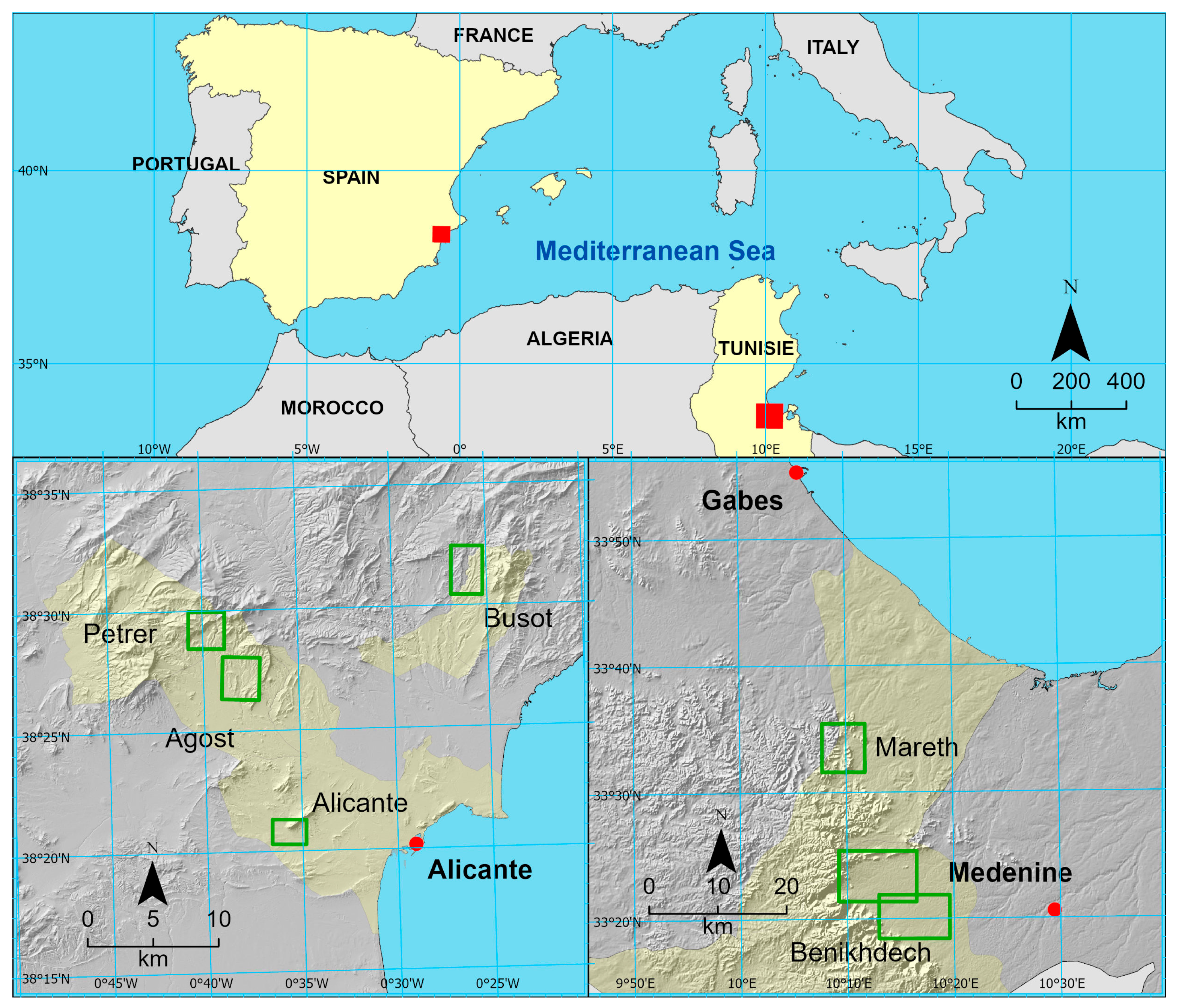
Figure 1. Location of study areas. Source: author.
Geographies 05 00032 g001
Figure 2. Location of the mgoud of Bhira, in Benikhdech, Medenine, Tunisia, in its geomorphic context. Red boxes indicate sectors A–C analyzed in the study Source: author, from photointerpretation of Google Earth images.
Geographies 05 00032 g002
Figure 3. Detailed mapping of sectors (AC), shown in Figure 2, of the mgoud of Bhira, Benikhdech, Medenine, Tunisia. Source: author.
Geographies 05 00032 g003
Figure 4. The location of the mgoud of the Wadi Ahimeur and others, in Benikhdech, Medenine, Tunisia, in its geomorphic context. Source: author, from photointerpretation of Google Earth images.
Geographies 05 00032 g004
Figure 5. A reinforced manfas (overflow) for the return of excess water to the Wadi in one of the mgouds of Ahimeur. Source: author.
Geographies 05 00032 g005
Figure 6. Location of the mgoud sector of the Wadi Ouarifene in Mareth, Gabes, Tunisia, in its geomorphic context. Source: author, from photointerpretation of Google Earth images.
Geographies 05 00032 g006
Figure 7. Detailed land use mapping of the Ouarifene mgoud sector, shown in Figure 6, in Mareth, Gabes, Tunisia. Source: author.
Geographies 05 00032 g007
Figure 8. (a) Entrance channel of a mgoud from the Ouarifene sector. Note the protection on the side with dry stone. (b) A mgoud with a manfas (overflow) reinforced with stones. Source: author.
Geographies 05 00032 g008
Figure 9. Cases of daily rainfall above 10 mm/day and 30 mm/day in Matmata during the period of 1979–2014. Author, from [38].
Geographies 05 00032 g009
Figure 10. A geomorphological map of the sector of the three boqueras of the Masía de la Tosca, in the Rambla de Busot. Source: author.
Geographies 05 00032 g010
Figure 11. La Revuelta reservoir site: 1. dike; 2. old outlet that distributed water through the agricultural area created at the expense of filling the reservoir; 3. tunnel of the glacis lobe, excavated for water management; 4. second tunnel and its water conduction channel; 5. diversion dam and corresponding outlet, built after the tunnel was opened. source: [25].
Geographies 05 00032 g011
Figure 12. A geomorphic map of the area of the boqueras of the Masía de la Revuelta in the Blanc ravine. Source: author.
Geographies 05 00032 g012
Figure 13. An abandoned meander in the Blanc ravine in Agost, with the main morphogenetic elements and the location of the La Revuelta dike indicated. Source: author.
Geographies 05 00032 g013
Figure 14. (a) The Revuelta dike, on the old route of the Blanc ravine in Agost. (b) The entrance to the tunnel through which the current courses in the Blanc ravine. Source: author.
Geographies 05 00032 g014
Figure 15. Hand sketch, from the 1956 photographic flight, of the traditional water works in the El Salt ravine near Els Fontanars de Palomarets. Source: [26].
Geographies 05 00032 g015
Figure 16. (a) The Parat from which the two boqueras of the El Salt and Fontanars dels Palomarets systems start in Petrer. (b) The riverbed of the boquera de dalt (the western one), already raised above the ravine (on the left) and about to spill its waters into the glacis (on the right).
Geographies 05 00032 g016
Figure 17. An image of the aerial photograph of the 1956 ‘American flight’ showing the location of the Fontcalent parat and the area of water lamination with secondary nozzles. Source: author, based on [14].
Geographies 05 00032 g017
Figure 18. Fontcalent parat. The accumulation of detritic debris caused by the parat and the present-day gully. Source: author.
Geographies 05 00032 g018
Figure 19. Cases of daily rainfall above 10 and 30 mm/day near Agost (1979–2014). Source: author, from [38].
Geographies 05 00032 g019
Table 1. Areas irrigated by mgouds in the studied areas. Source: author.
MgoudNo.Mean Area (ha)Max. Area (ha)Min. Area (ha)
Bhira61.222.010.54
Ahimeur82.937.360.41
Ouarifene61.162.100.72
Disclaimer/Publisher’s Note: The statements, opinions and data contained in all publications are solely those of the individual author(s) and contributor(s) and not of MDPI and/or the editor(s). MDPI and/or the editor(s) disclaim responsibility for any injury to people or property resulting from any ideas, methods, instructions or products referred to in the content.