
Peatland-Type Sediment Filling in Valley Bottoms at the Head of Basins in a Stream Capture Context: The Example of the Bar and Petit Morin Peatland (Grand-Est, France)

 , , , , and
Abstract
1. Introduction
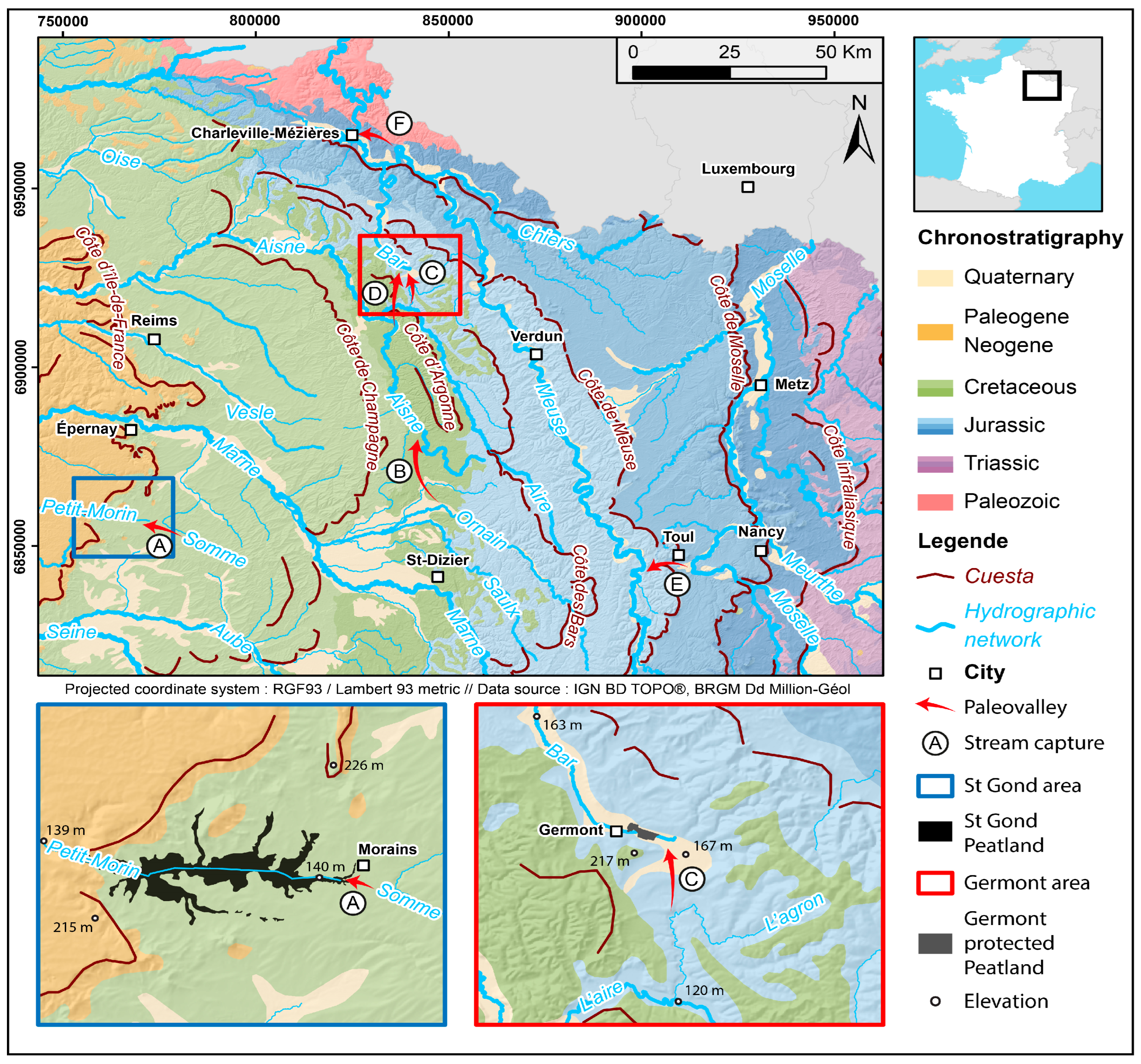
2. Study Area
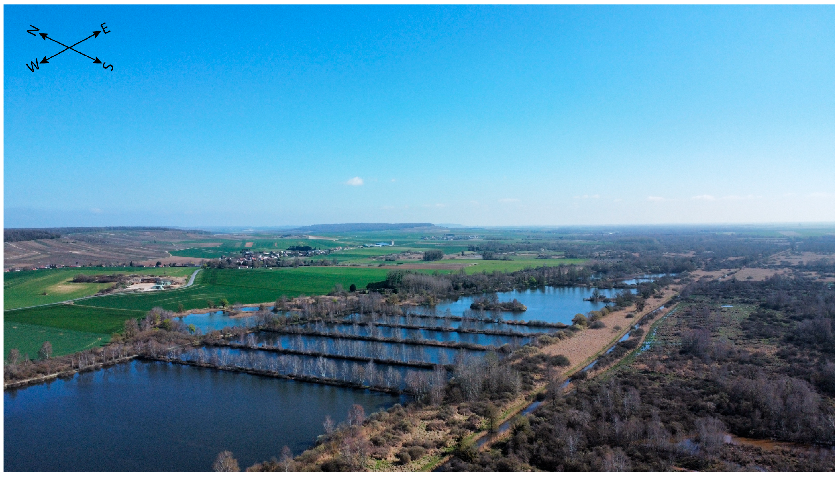
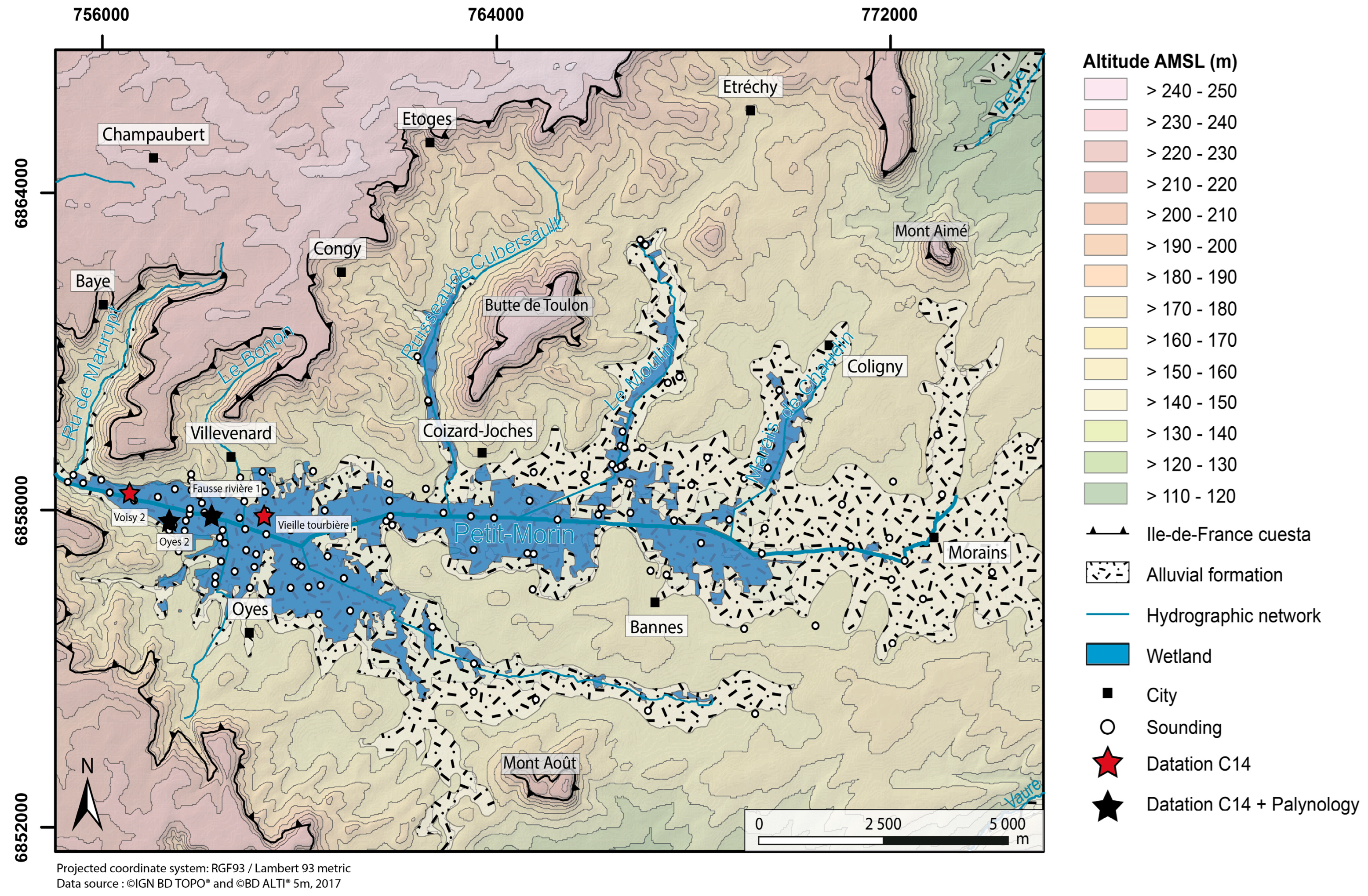
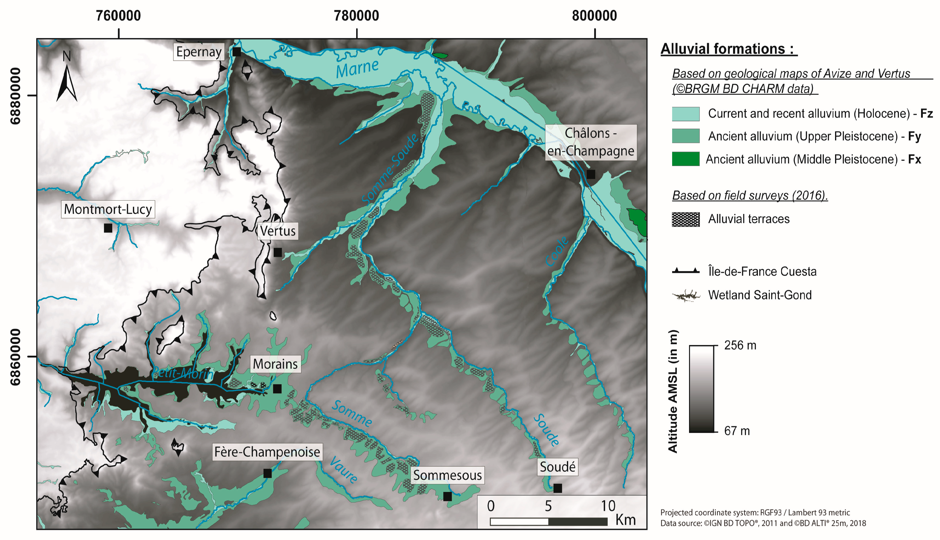
- The Saint-Gond marsh
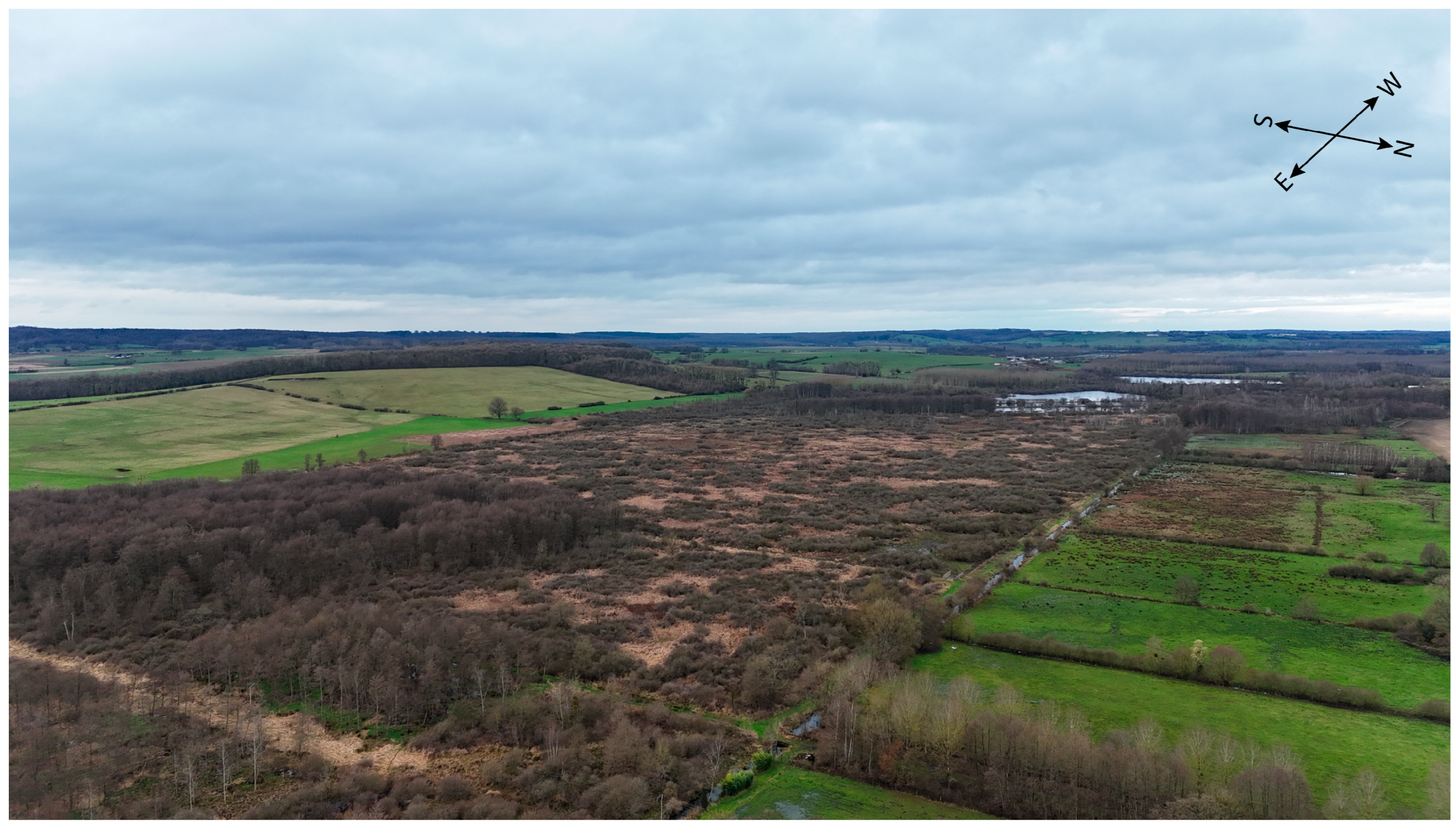
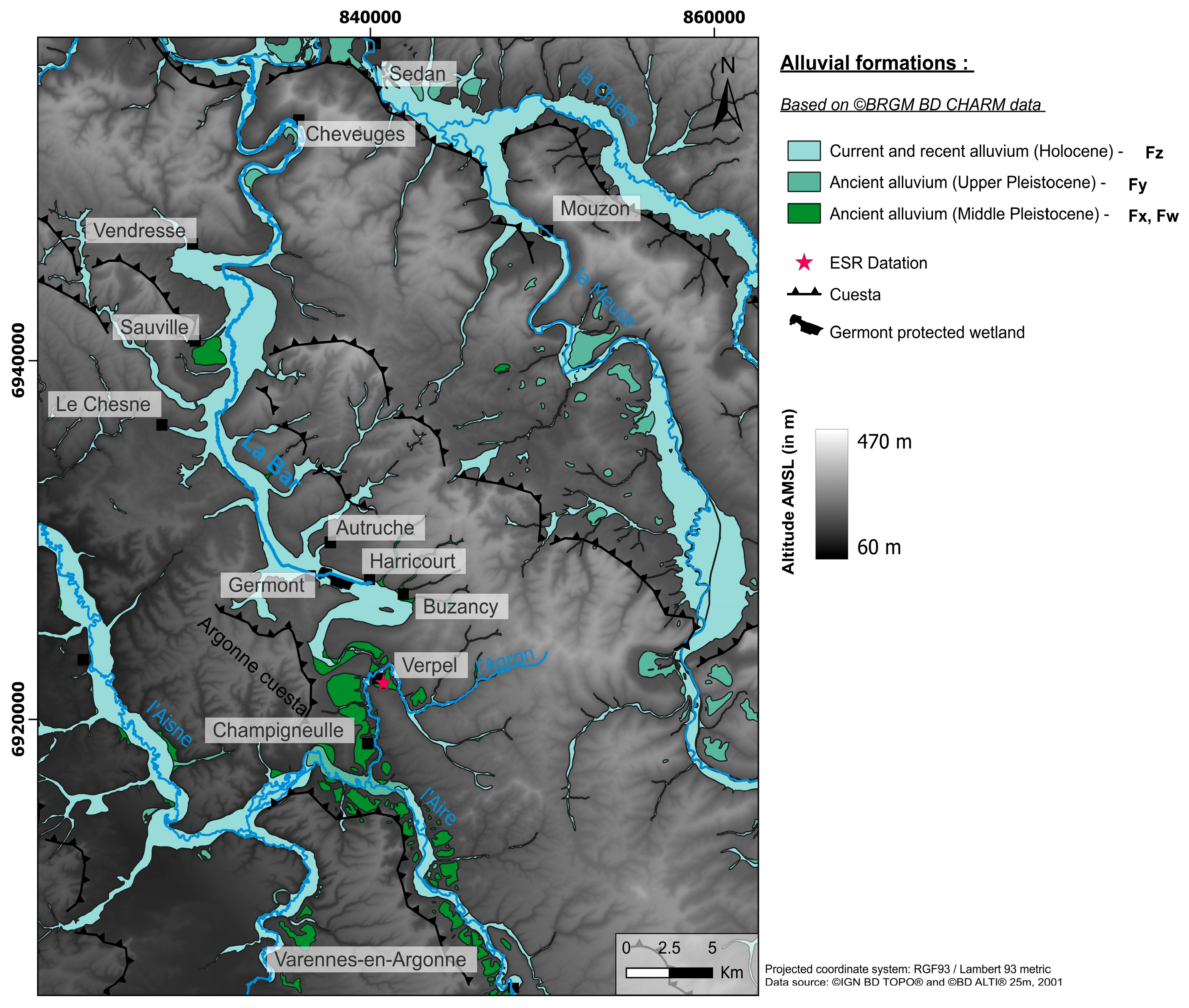
- The Germont-Buzancy marsh
3. Materials and Methods
3.1. Available Databases
3.2. Land Surveys
3.3. Laboratory Analyses
4. Results
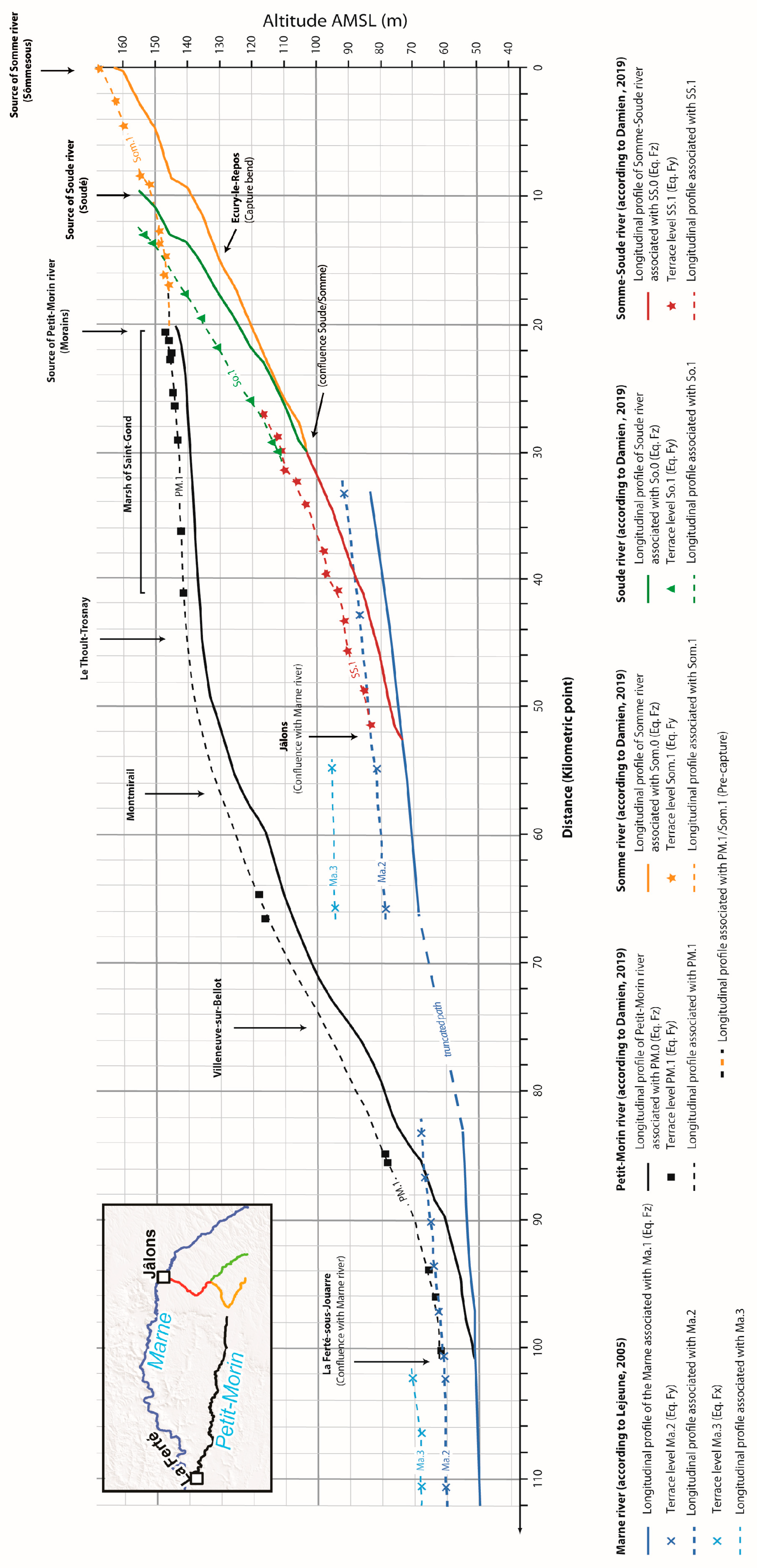
4.1. Spatial Pattern of Alluvial Terraces on a Regional Scale
4.2. Nature and Thickness of Alluvial Formations
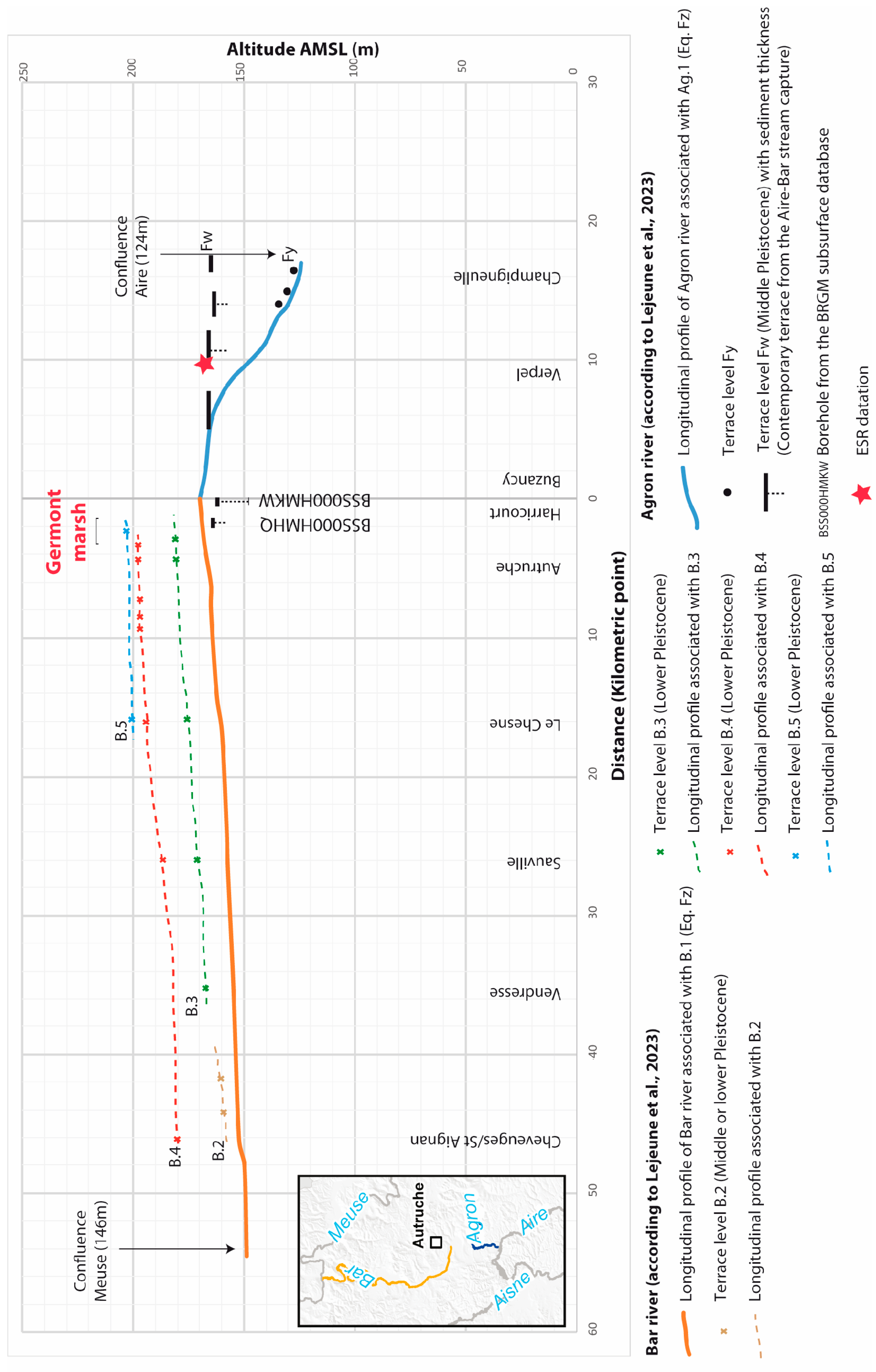
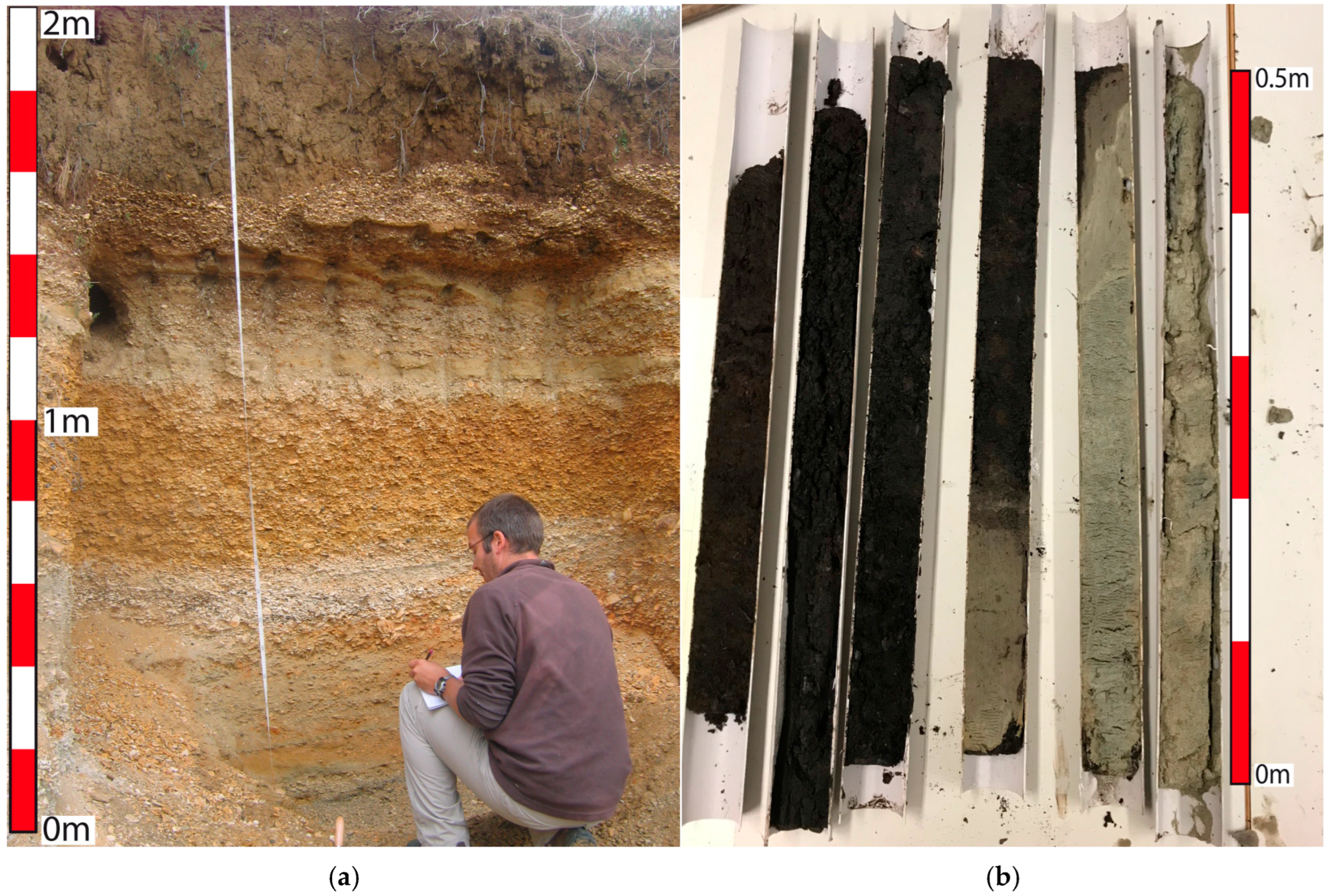
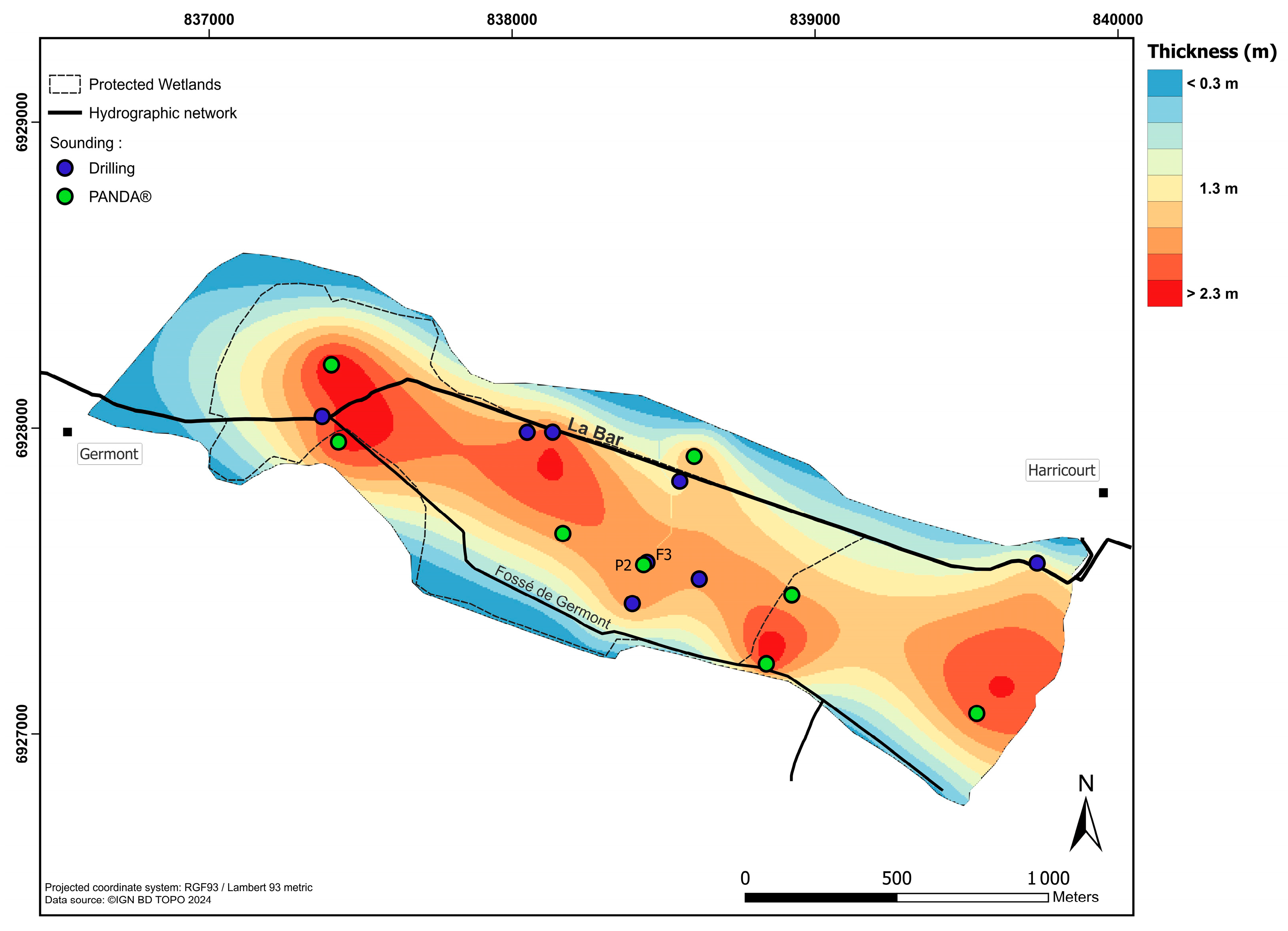
4.2.1. In the Germont Marsh Area
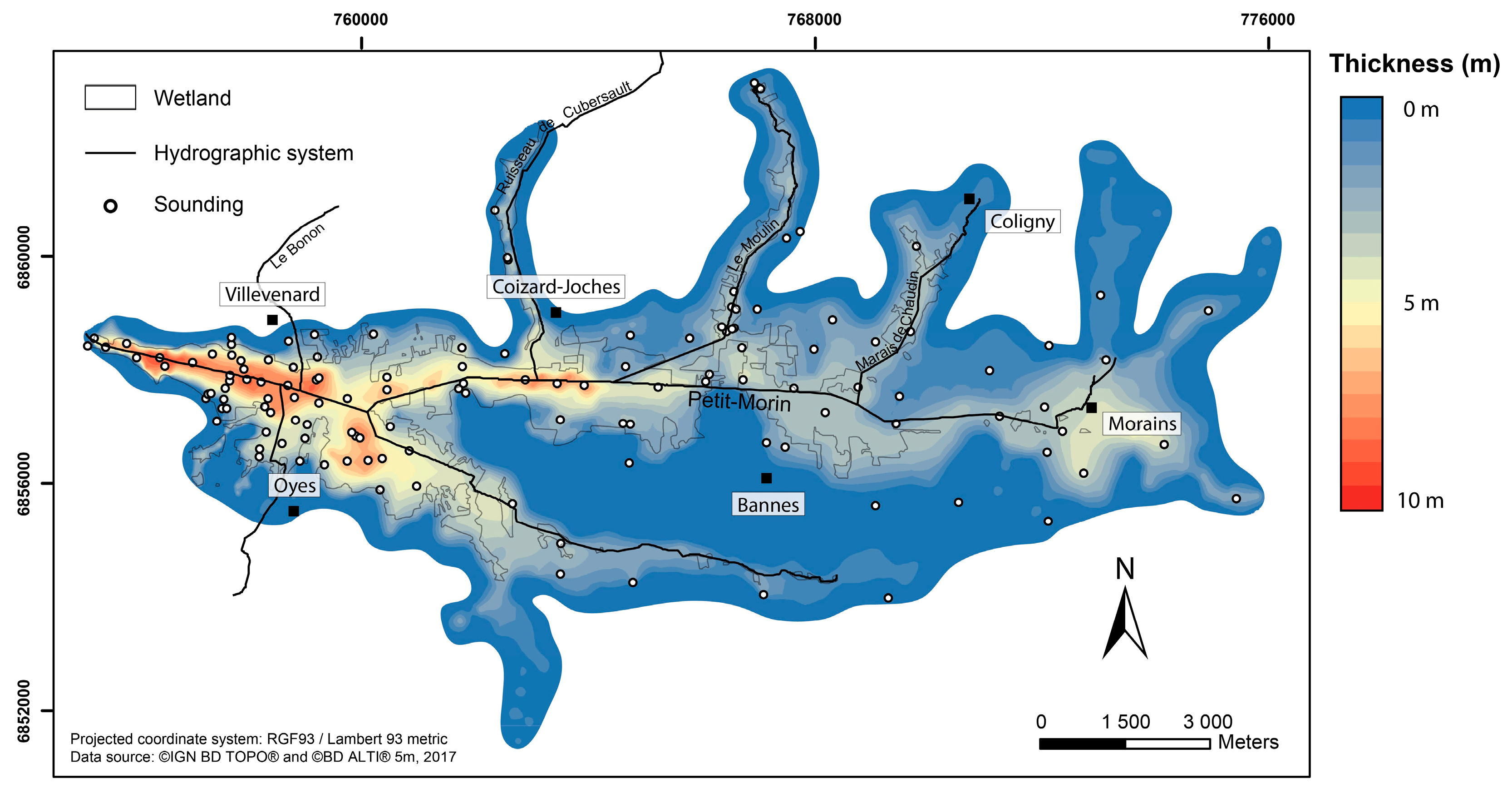
4.2.2. In the Saint-Gond Marsh Area
4.3. Alluvial Formations Dating
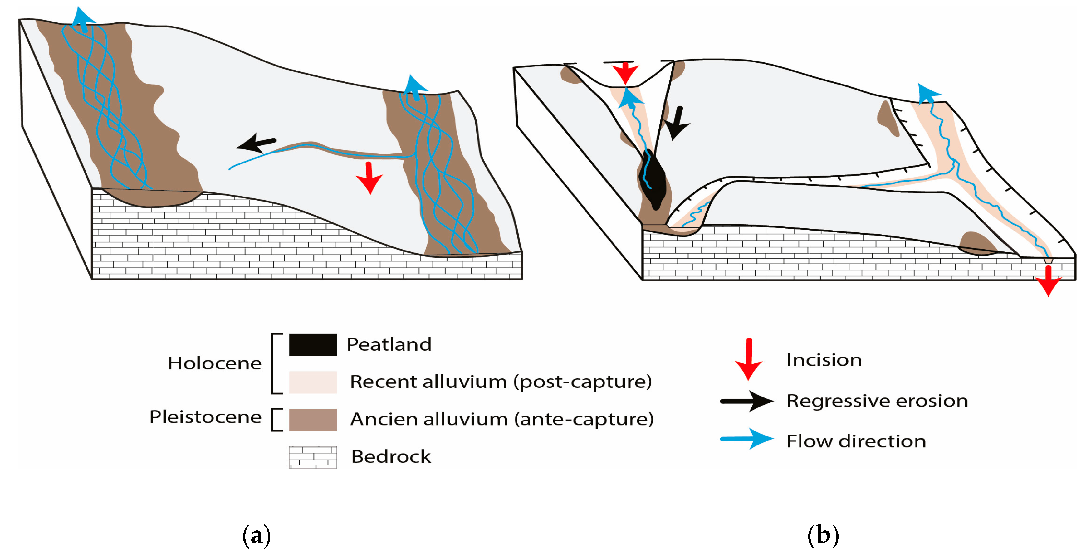
5. Discussion
6. Conclusions
Author Contributions
Funding
Data Availability Statement
Acknowledgments
Conflicts of Interest
References
- Messager, M.L.; Pella, H.; Datry, T. Inconsistent regulatory mapping quietly threatens rivers and streams. Environ. Sci. Technol. 2024, 58, 17201–17214. [Google Scholar] [CrossRef] [PubMed]
- Desta, H.; Lemma, B.; Fetene, A. Aspects of climate change and its associated impacts on wetland ecosystem functions—A review. J. Am. Sci. 2012, 8, 582–596. [Google Scholar]
- Jordan, T.E.; Whigham, D.F.; Hofmockel’, K.; Gerber, N. Restored wetlands in crop fields control nutrient runoff. In Nutrient Cycling and Retention in Natural and Constructed Wetlands; Vymazal, J., Ed.; Backhuys Publishers: Leiden, The Netherlands, 1999; pp. 49–60. [Google Scholar]
- Gorham, E. Northern Peatlands: Role in the Carbon Cycle and Probable Responses to Climatic Warming. Ecol. Appl. 1991, 1, 182–195. [Google Scholar] [CrossRef] [PubMed]
- Frolking, S.; Roulet, N.; Fuglestvedt, J. How northern peatlands influence the Earth’s radiative budget: Sustained methane emission versus sustained carbon sequestration. J. Geophys. Res. 2006, 111, G01008. [Google Scholar] [CrossRef]
- van Diggelen, R. Mires and Peatlands of Europe: Status, Distribution and Conservation. Restor. Ecol. 2018, 26, 1005–1006. [Google Scholar] [CrossRef]
- Zhong, Y.; Jiang, M.; Middleton, B.A. Effects of water level alteration on carbon cyclingin peatlands. Ecosyst. Health Sustain. 2020, 6, 1806113. [Google Scholar] [CrossRef]
- RAMSAR Convention. 1971. Available online: https://www.ramsar.org/fr (accessed on 6 June 2025).
- Mitsch, W.J.; Gosselink, J.G. Wetlands; John Wiley & Sons: Hoboken, NJ, USA, 2015; 752p. [Google Scholar]
- Yu, Z.C. Northern peatland carbon stocks and dynamics: A review. Biogeosciences 2012, 9, 4071–4085. [Google Scholar] [CrossRef]
- Griffiths, N.A.; Sebestyen, S.D.; Oleheiser, K.C. Variation in peatland porewater chemistry over time and space along a bog to fen gradient. Sci. Total Environ. 2019, 697, 134152. [Google Scholar] [CrossRef]
- Blodau, C.; Moore, T.R. Experimental response of peatland carbon dynamics to a water table fluctuation. Aquat. Sci.-Res. Boundaries 2003, 65, 47–62. [Google Scholar] [CrossRef]
- Lhosmot, A.; Collin, L.; Magnon, G.; Steinmann, M.; Bertrand, C.; Stefani, V.; Toussaint, M.; Bertrand, G. Restoration and meteorological variability highlight nested water supplies in middle altitude/latitude peatlands: Towards a hydrological conceptual model of the Frasne peatland, Jura Mountains, France. Ecohydrology 2021, 14, e2315. [Google Scholar] [CrossRef]
- Ministère de L’industrie et du Commerce. Etude économique. In Les Tourbières Françaises—Atlas des Mines; Report Submitted to Ministère de L’industrie et du Commerce; Pôle-Relais Tourbières: Besançon, France, 1949; pp. 163–181. [Google Scholar]
- Ministère de L’industrie et du Commerce. Historique de la Prospection. In Les Tourbières Françaises—Atlas des Mines; Report Submitted to Ministère de L’industrie et du Commerce; Pôle-Relais Tourbières: Besançon, France, 1949; pp. 9–158. [Google Scholar]
- Gilbert, D.; Muller, F.; Bernard, G.; Pilloix, M. Digitized Inventory of the French Peatlands of 1949; Laboratoire Chrono-Environnement: Besançon, France, 2021. [Google Scholar] [CrossRef]
- Pinault, L.; Pilloix, M.; Bernard, G.; Joly, D.; Gogo, S.; Martin, E.; Gilbert, D. The 1949 Atlas of French peat deposits, a starting point for a national inventory of peatlands. Soil Use Manag. 2023, 39, 1040–1056. [Google Scholar] [CrossRef]
- Pinault, L.; Gilbert, D.; Martin, E. Potential of peatlands restoration for GHG emissions mitigation in France: Investigation of acquisition costs. Land Use Policy 2025, 153, 107538. [Google Scholar] [CrossRef]
- Davis, W.M. The Seine, the Meuse and the Moselle. National Géographic Magazine 1896, VII, 189–202. [Google Scholar] [CrossRef]
- Blache, J. Le problème des méandres encaissés et les rivières lorraines. J. Geomorphol. 1939, 2, 201–212. [Google Scholar]
- Blache, J. Le problème des méandre sencaissés et les rivières lorraines. J. Geomorphol. 1940, 3, 311–331. [Google Scholar]
- Tricart, J. La partie Orientale du Bassin de Paris (Etude Morphologique); Paris, 2 t. (t. I: La Genèse du Bassin; t. 2: L’évolution Morphologique au Quaternaire); S.E.D.E.S: Paris, France, 1952; 473p. [Google Scholar]
- Harmand, D. Histoire de la Vallée de la Meuse Lorraine; PUN (Coll. Etudes Géographiques): Nancy, France, 1992; 146p. [Google Scholar]
- Harmand, D.; Le Roux, J. La capture de la Haute Moselle. Bull. Info. Géol. Bass. 2000, 37, 4–14. [Google Scholar]
- Losson, B. Karstification et capture de la Moselle (Lorraine, France): Vers une identification des interactions. Mosella 2004, XXIX, ⟨hal-03022516⟩. [Google Scholar]
- De Wever, P.; Guillocheau, F.; Reynaud, J.-Y.; Vennin, E.; Robin, C.; Cornée, A.; Rouby, D. Two centuries of stratigraphy in the Paris Basin. Comptes Rendus Palevol. 2002, 1, 399–414. [Google Scholar] [CrossRef]
- Allouc, J.; Hanot, F.; Hibsch, C. Les craies fracturées-indurées (CFI) de la “craie blanche” de Champagne. Géologie de la France 2020, 4, 67–96. [Google Scholar]
- Damien, T. Comportement Hydrodynamique des Marais de Saint-Gond (Marne, France). Thèse de Doctorat, Université de Reims, Reims, France, 2019; 351p. [Google Scholar]
- De Martonne, E. Traité de Géographie Physique: Climat, Hydrographie, Relief du sol, Biogéographie; Armand Colin: Paris, France, 1909; 912p. [Google Scholar]
- Lejeune, O. Dynamiques D’érosion des bas Plateaux de l’Est de la France: L’exemple du Bassin-Versant Amont de la Marne. Thèse de Doctorat, Université de Reims Champagne-Ardenne, Reims, France, 2005; 571p. [Google Scholar]
- Blache, J. Captures comparées.—La vallée morte de la Bar et les cas voisins. Revue de Géographie Alpine 1943, 31, 37. [Google Scholar] [CrossRef]
- Tilloy, R. Les rivières de l’Argonne au Quaternaire. Bulletin de la Société Géologique de France 1946, XVI, 79–83. [Google Scholar] [CrossRef]
- Laurent, J. L’Argonne et ses Bordure. Ph.D. Thesis, University of Paris 1, Paris, France, 1948; 310p. [Google Scholar]
- Voisin, L. Le Modelé Schisteux en Zones Froide et Tempérée: Mécanismes Générateurs et Formes Essentielles. Thèse de Doctorat d’État, Université de Lille, Lille, France, 1952. [Google Scholar]
- Buvignier, A. Réunion extraordinaire à Joinville du 7 au 14-9-1856. Séance du vendredi 12 septembre à St-Dizier. Communication de A. Buvignier. Bulletin de la Société Géologique de France, 2ème Série 1856, 13, 870–872. [Google Scholar]
- De Lappavent, A. Un épisode de l’histoire de la Bar. Annales de Géographie 1897, 25, 79–80. [Google Scholar] [CrossRef]
- Deshaies, M. Les Méandres Encaissés dans les Plateaux Calcaires de la France de L’est. Thèse de Doctorat, Université de Nancy II, Nancy, France, 1994; 381p. [Google Scholar]
- Pissart, A.; Harmand, D.; Krook, L. L’évolution de la Meuse de Toul à Maastricht depuis le Miocène: Corrélation chronologiques et traces des captures de la Meuse Lorraine d’après les minéraux denses. Géographie Physique et Quaternaire 1997, 51, 267–284. [Google Scholar] [CrossRef]
- Pissart, A.; Harmand, D.; Krook, L. Modifications du tracé de la Meuse dans la région de Charleville-Mézières en liaison avec les captures de l’Aisne et de la Moselle. Bulletin de la Société Géographique de Liège 1998, 35, 29–39. Available online: https://popups.uliege.be/0770-7576/index.php?id=2816 (accessed on 6 June 2025).
- Harmand, D.; Pissart, A.; Krook, L. L’évolution du Paléo-Bassin de la Meuse: Les Enseignements des Captures et Leurs Implications Environnementqles. In Saar-Lor-Lux, Problèmes de I’environnement; Résultats Colloque Commun Instituts de Géographie des Universités de Metz, Nancy et Sarrebruck: Saarbriicken, Germany; Universität des Saarlandes: Saarbrücken, Germany, 1998; Volume 44, pp. 157–173. [Google Scholar]
- Pissart, A.; Krook, L.; Harmand, D. La capture de l’Aisne et les minéraux denses des alluvions de la Meuse dans les Ardennes. Comptes Rendus de l’Académie des Sciences—Series IIA—Earth and Planetary Science 1997, 325, 411–417. [Google Scholar] [CrossRef]
- Pissart, A.; Krook, L. Les minéraux denses des terrasses de la Meuse près de Chooz (Ardennes, France). Bulletin de la Société Géographique de Liège 2004, 44, 115–120. Available online: https://hdl.handle.net/2268/249585 (accessed on 6 June 2025).
- Pierre, P.; Bahain, J.-J.; Falguères, C.; Laurent, M.L.; Dolo, J.-M.; Despriée, J.; Gageonnet, R.; Chaussé, C. ESR dating of quartz extracted from Quaternary sediments application to fluvial terraces system of northern France. Quaternaire 2004, 15, 135–141. [Google Scholar] [CrossRef]
- Voinchet, P. (Ed.) Datation par Methode esr de Terrasses Alluviales du Bassin de Paris: Campagne 2009; Rapport Andra, n°C.RP.0MNH.09.0001.A; Andra: Chatenay-Malabry, France, 2009; 63p. [Google Scholar]
- Genuite, K.; Voinchet, P.; Nehme, C.; Todisco, D.; Bahain, J.-J.; Ballesteros, D.; Farrant, A.R.; Girault, I.; Grappone, J.M.; Philippe, A.; et al. Quaternary landscape evolution of the river Seine (France): Synthesis and new results from ESR dating and magnetostratigraphy of fluvial and cave deposits. Quat. Sci. Rev. 2025, 349, 109063. [Google Scholar] [CrossRef]
- Maquaire, O.; Ritzenthaler, A.; Fabre, D.; Ambroise, B.; Thiery, Y.; Truchet, E.; Malet, J.-P.; et Monnet, J. Caractérisation des profils de formations superficielles par pénétrométrie dynamique à énergie variable: Application aux marnes noires de Draix (Alpes-de-Haute-Provence, France). Comptes Rendus Géosciences 2002, 334, 835–841. [Google Scholar] [CrossRef]
- Villavicencio, G.; Bacconnet, C.; Valenzuela, P.; Palma, J.; Carpanetti, A.; Suazo, G.; Silva, M.; García, J. The Use of Lightweight Penetrometer PANDA for the Compaction Control of Classified Sand Tailings Dams. Minerals 2022, 12, 1467. [Google Scholar] [CrossRef]
- Depreux, B.; Quiquerez, A.; Bégeot, C.; Camerlynck, C.; Walter-Simonnet, A.-V.; Ruffaldi, P.; Martineau, R. Small headwater stream evolution in response to Lateglacial and Early Holocene climatic changes and geomorphological features in the Saint-Gond marshes (Paris Basin, France). Geomorphology 2019, 345, 106830. [Google Scholar] [CrossRef]
- Lejeune, O.; Foucault, M.; Berthe, J.; Jaunat, J.; Louis, P.; Hubert, J.; Guillaneuf, A.; Devos, A.; Bollot, N. Programme PALMAGE: Paléoenvironnement des marais de Germont. In Proceedings of the colloque inaugural de la ZARG Environnementale rurale Argonne, Olisy-primat, France, 26–29 September 2023. ⟨hal-04219245⟩. [Google Scholar]
- Passega, R. Analyses granulométriques: Outil géologique pratique ? Revue de L’institut Français du Pétrole 1963, 11, 1489–1499. [Google Scholar]
- Passega, R. Grain size representation by CM patterns as a geological tool. J. Sediment. Petrol. 1964, 34, 830–847. [Google Scholar] [CrossRef]
- Losson, B. Karstification et Capture de la Moselle (Lorraine/France): Vers une Identification des Interactions. Thèse de Doctorat, Université de Metz, Metz, France, 2003; 737p. [Google Scholar]
- Laurain, M.; Guerin, H.; Marre, A.; Richard, J.; French, H.-M. Processus génétiques à l’origine des formations de pente à graviers de craie en Champagne. Permafr. Periglac. Process. 1995, 6, 103–108. [Google Scholar] [CrossRef]
- Lejeune, O.; Berthe, J.; Devos, A.; Bollot, N.; Krauffel, T. Evolution du Pléistocène Moyen à nos Jours d’un Site de Tourbière de Fond de Vallée: L’exemple du Marais de Germont/Buzancy. In Proceedings of the 6e Colloque Du Réseau des Zones Ateliers CNRS, Zone Atelier Argonne, Sainte-Menehould, France, 17–19 September 2024. [Google Scholar]
- Cojan, I.; Brulhet, J.; Corbonnois, J.; Devos, A.; Gargani, J.; Harmand, D.; Jaillet, S.; Jouve, A.; Laurain, M.; Lejeune, O.; et al. Morphologic evolution of eastern Paris basin: Ancient surfaces and Quaternary incisions. Mémoire de la Société Géologique de France 2007, 178, 135–155. [Google Scholar] [CrossRef]
- Cordier, S.; Kalicki, T.; Lauer, T.; Rixhon, G.; Van Balen, R.T. Twenty-five years of flag activity: Concepts, foci, trends in research. Geomorphology 2021, 373, 107443. [Google Scholar] [CrossRef]
- Gallen, S.F.; Wegmann, K.W. The impact of river capture on fluvial terraces and bedrock incision. Earth Surf. Process. Landf. 2025, 50, 1–17. [Google Scholar] [CrossRef]
- Stamm, J.F.; Hendricks, R.R.; Foster Sawyer, J.; Mahan, S.A.; Zaprowski, B.J.; Geibel, N.M.; Azzolini, D.C. Late Quaternary stream piracy and strath terrace formation along the Belle Fourche and lower Cheyenne Rivers, South Dakota and Wyoming. Geomorphology 2013, 197, 10–20. [Google Scholar] [CrossRef]
- Benaïchouche, A.; Stab, O.; Tessier, B.; Cojan, I. Evaluation of a landscape evolution model to simulate stream piracies: Insights from multivariable numerical tests using the example of the Meuse basin, France. Geomorphology 2016, 253, 168–180. [Google Scholar] [CrossRef]
- Maher, E.; Harvey, A.-M.; France, D. The impact of a major Quaternary river capture on the alluvial sediments of a beheaded river system, the Rio Alias SE Spain. Geomorphology 2007, 84, 344–356. [Google Scholar] [CrossRef]
- Harmand, D.; Adamson, K.; Rixhon, G.; Jaillet, S.; Losson, B.; Devos, A.; Hez, G.; Calvet, M.; Audra, P. Relationships between fluvial evolution and karstification related to climatic, tectonic and eustatic forcing in temperate regions. Quat. Sci. Rev. 2017, 166, 38–56. [Google Scholar] [CrossRef]
- Brown, A.G.; Lespez, L.; Sear, D.A.; Macaire, J.J.; Houben, P.; Klimek, K.; Brazier, R.E.; Van Oost, K.; Pears, B. Natural vs anthropogenic streams in Europe: History, ecology ans implications for restoration, river-rewilding and riverine ecosystem services. Earth-Sci. Rev. 2018, 180, 185–205. [Google Scholar] [CrossRef]
- Porteret, J. Fonctionnement Hydrologique des Têtes de Bassin Versant Tourbeuses du Nord-Est du Massif Central. Thèse de Doctorat, Université de Saint-Etienne, Saint-Etienne, France, 2008; 431p. [Google Scholar]
- Damien, T.; Briquet, M.; Bollot, N.; Devos, A.; Chalumeau, L.; Pierre, G.; Lejeune, O. Rôle des remplissages alluviaux sur le fonctionnement hydrodynamique d’un marais d’entonnoir de percée cataclinale: L’exemple des Marais de Saint-Gond (Marne, France). Géomorphologie 2015, 21, 331–340. [Google Scholar] [CrossRef]
- Devos, A.; Lejeune, O.; Chopin, E. Structural control on surface flow in karstic environnement. Geodin. Acta 2007, 20, 393–402. [Google Scholar] [CrossRef]
- Gauthier, E.; Jassey, V.; Mitchell, E.; Lamentowicz, M.; Payne, R.; Delarue, F.; Laggoun-Defarge, F.; Gilbert, D.; Richard, H. From climatic to Anthropogenic Drivers: Multi-proxy reconstruction of vegetation and peatland development in the French Jura Mountains. Quaternary 2019, 2, 38. [Google Scholar] [CrossRef]
- Patel, N.; Ievina, B.; Kazmere, D.; Feofilovs, M.; Kamenders, A.; Romagnoli, F. Towards resilient peatlands: Integrating ecosystem-based strategies, policy frameworks, and management approaches for sustainable transformation. Sustainability 2025, 17, 3419. [Google Scholar] [CrossRef]
- Stachowicz, M.; Lyngstad, A.; Osuch, P.; Grygoruk, M. Hydrological response to rewetting of drained peatlands—Case study of three raised bogs in norway. Land 2025, 14, 142. [Google Scholar] [CrossRef]
- Giannini, V.; Peruzzi, E.; Masciandaro, G.; Doni, S.; Macci, C.; Bonari, E.; Silvestri, N. Comparison among different rewetting strategies of degraded arcicultural peaty soils: Short-term effects on chemical properties and ecoenzymatics activities. Agronomy 2020, 10, 1084. [Google Scholar] [CrossRef]
- Flood, K.; Wilson, D.; Renou-Wilson, F. Evidence Synthesis and Knowledge Integration for Sustainable Peatland Management. Land 2025, 14, 1397. [Google Scholar] [CrossRef]
- Schneider, P.; Fauk, T.; Mihai, F.-C.; Junker, H.; Ettner, H.; Lüderitz, V. Natural climate protection through peatland rewetting: A future for the rathsbruch peatland in Germany. Land 2024, 13, 581. [Google Scholar] [CrossRef]
- Zak, D.; McInnes, R.J. A call for refining the peatland restoration strategy in Europe. J. Appl. Ecol. 2022, 59, 2698–2704. [Google Scholar] [CrossRef]
- Zou, J.; Ziegler, A.D.; Chen, D.; McNicol, G.; Ciais, P.; Jiang, X.; Zheng, C.; Wu, J.; Wu, J.; Lin, Z.; et al. Rewetting global wetlands effectively reduces major greenhouse gas emissions. Nat. Geosci. 2022, 15, 627–632. [Google Scholar] [CrossRef]
- Balode, L.; Bumbiiere, K.; Sosars, V.; Valters, K.; Blumberga, D. Pros and cons of strategies to reduces grenhouse gas emissions from peatlands: Review of possibilities. Appl. Sci. 2024, 14, 2260. [Google Scholar] [CrossRef]
- McDermid, G.; Terenteva, I.; Chan, X. Mapping trails and tracks in the boreal forest using LiDAR and convolutional neural networks. Remote Sens. 2025, 17, 1539. [Google Scholar] [CrossRef]
- Bollot, N.; Benoit, A.; Berthe, J.; Combaz, D.; Krauffel, T.; Devos, A.; Lejeune, O.; Ancelin, P.-Y. Analysis of the Evolution of Lowland Landslides in Temperate Environments According to Climatic Conditions Based on LiDAR Data: A Case Study from Rilly (Champagne Vineyard Region, Northeastern France). Geosciences 2025, 15, 191. [Google Scholar] [CrossRef]
- Antala, M.; Rastogi, A.; Strozecki, M.; Albert-Saiz, M.; Bandopadhyay, S.; Juszczak, R. Evaluating remote sensing metrics for land surface phenology in peatlands. Remote Sens. 2025, 17, 32. [Google Scholar] [CrossRef]


| Mapping Type | Scale | Author | Note | References |
|---|---|---|---|---|
| Geological map | 1/50,000 | BRGM | Bd charm (National geological database) | https://infoterre.brgm.fr/formulaire/telechargement-cartes-geologiques-departementales-150-000-bd-charm-50 (accessed on 6 June 2025) |
| Drilling | / | BRGM | BSS (subsoil database) | https://infoterre.brgm.fr/page/banque-sol-bss (accessed on 6 June 2025) |
| Geomorphological map | 1/10,000 | Gegena lab | Geomorphological map of the Marne valley | [30] |
| Geomorphological map | 1/10,000 | Gegena lab | Geomorphological map of the Saint-Gond marsh area | [28] |
| Geomorphological map | 1/10,000 | Andra and Personal data | Geomorphological map of the Germont marsh area and nearby valleys | Study in progress |
| Analysis Type | Category | Operator | Note | Completion Date |
|---|---|---|---|---|
| ESR (Electronic spin resonance) | Dating | MNHN | Dating alluvial terraces | 2005–2009 |
| 14C (Carbon 14) | Dating | Poznan Radiocarbon Laboratory | Peat dating | 2017 (Saint-Gond marshes) 2022 (Germont marshes) |
| Core drilling | Reconquering the subsoil | Gegena lab | Russian core drilling | 2014–2018 (Saint-Gond marshes) 2022–2025 (Germont marshes) |
| PANDA® | Geotechnical investigation | Gegena lab | Rapid reconnaissance of the subsoil | 2022–2025 (Germont marshes) |
| Palynological analysis | Paleoenvironmental analysis | Gegena lab Chrono-environment lab | 2016 (Saint-Gond marshes) Analysis in progress (Germont marshes) |
| Analysis Type | Category | Operator | Note | Equipment |
|---|---|---|---|---|
| Granulometry | Sediment analysis | Gegena lab | For analyses under 1.6 mm For analyses above 50 µm | laser granulometer (Mastersizer 3000) Mechanical particle sizing |
| X-ray fluorescence | Geochemical analysis | Gegena lab | 32 chemical parameters | Niton Xl3t 980 |
| loss on ignition (LOI) | Organic matter analysis | Gegena lab | 550 °C for four hours | Muffle furnace |
| Sedimentary Unit (Germont) | Type of Sediment | Organic Matter (%Min, %Max) | Thickness (m) | Dating | Granulometry |
|---|---|---|---|---|---|
| US 3 | Peat | 40–90% | 1.3 m (min); 2.7 m (max) | (14C method) 1070 ± 30 BP (subsurface) 12,000 ± 60 BP (base) | / |
| US 2 | Sandy clay loam | 0–2% | 2 m (min); 7 m (max) | / | Clay and silt: 49.6% ± 13.9 Sand: 50.4% ± 14.1 Pebbles and cobbles: 0% |
| US 1 | Pebbles and cobbles | 0% | 10 m (max) | (ESR method) 450 ky ± 100 | Clay and silt: 5.36% ± 4.52 Sand: 50.21% ± 29.65 Pebbles and cobbles: 44.17% ± 31.66 |
| Sedimentary Unit (Germont) | Type of Sediment | Organic Matter (%Min, %Max) | Thickness (m) | Dating | Granulometry |
|---|---|---|---|---|---|
| US.5 | Peat | 65–80% | 1.9 m (max) | (14C method) 895 ± 30 BP (subsurface) 9910 ± 50 BP (base) | / |
| US.4 | Lacustrine silty clay | 1% (max) | 1 m (max) | / | Clay and silt: 71.2% ± 13.2% Sand: 28.8% ± 11.4% Pebbles and cobbles: 0% |
| US.3 | Peat | 80–95% | 0.9 m (max) | (14C method) 11,030 ± 50 BP (subsurface) 12,440 ± 50 BP (base) | / |
| US.2 | Lacustrine silty clay | 0.5% | 1.6 (max) | / | Clay and silt: 77.3% ± 9.9 Sand: 22.7% ± 18.2 Pebbles and cobbles: 0% |
| US.1 | Pebbles «graveluches» | 1.5% | 5 m (max) | (ESR method) 93 ky ± 9 112 ky ± 13 | Clay and silt: 29.9% ± 9.44 Sand: 29.1% ± 14.5 Pebbles and cobbles: 41% ± 17.12 |
| Drilling Name | Depth (cm) | Sample Number | Age 14C BP |
|---|---|---|---|
| Voisy 2 | 198 | Poz-74873 | 3355 ± 30 |
| Vielle Tourbière | 204 | Poz-74874 | 11,910 ± 60 |
| Oyes 2 | 30 | Poz-86929 | 895 ± 30 |
| Oyes 2 | 70 | Poz-87012 | 1725 ± 30 |
| Oyes 2 | 110 | Poz-87014 | 2265 ± 30 |
| Oyes 2 | 160 | Poz-87013 | 7740 ± 35 |
| Oyes 2 | 190 | Poz-74614 | 9910 ± 50 |
| Oyes 2 | 228 | Poz-87015 | 11,030 ± 50 |
| Oyes 2 | 266 | Poz-74613 | 11,700 ± 60 |
| Oyes 2 | 301 | Poz-74612 | 12430 ± 60 |
| Fausse Rivière 1 | 148 | Poz-74875 | 8490 ± 50 |
| Fausse Rivière 1 | 325 | Poz-74615 | 12,440 ± 60 |
| Drilling Name | Depth (cm) | Sample Number | Age 14C BP |
|---|---|---|---|
| F1C1E1 | 25 | Poz-156461 | 1070 ± 30 BP |
| F1C1E3 | 75 | Poz-156247 | 1685 ± 30 BP |
| F1C1E4 | 98 | Poz-156996 | 3630 ± 30 BP |
| F1C1E5 | 122 | Poz-156998 | 6560 ± 40 BP |
| F1C1E6 | 148 | Poz-156999 | 8530 ± 50 BP |
| F1C1E7 | 167 | Poz-157094 | 10,800 ± 60 BP |
| F1C1E8 | 180 | Poz-157090 | 12,000 ± 60 BP |
| Sedimentary Section Name | Depth (cm) | Sample Number | ESR Age (Ma) |
|---|---|---|---|
| Verpel | 180 | 09VER01 | 0.45 ± 0.1 |
| Sedimentary Section Name | Depth (cm) | Sample Number | ESR Age (Ma) |
|---|---|---|---|
| Donjeux | 210 | 2003DON07 | 0.112 ± 0.013 |
| Loisy | 140 | 01LOI01 | 0.093 ± 0.009 |
Disclaimer/Publisher’s Note: The statements, opinions and data contained in all publications are solely those of the individual author(s) and contributor(s) and not of MDPI and/or the editor(s). MDPI and/or the editor(s) disclaim responsibility for any injury to people or property resulting from any ideas, methods, instructions or products referred to in the content. |
© 2025 by the authors. Licensee MDPI, Basel, Switzerland. This article is an open access article distributed under the terms and conditions of the Creative Commons Attribution (CC BY) license (https://creativecommons.org/licenses/by/4.0/).
Share and Cite
Lejeune, O.; Beucher, J.; Devos, A.; Berthe, J.; Damien, T.; Combaz, D.; Bollot, N.; Krauffel, T. Peatland-Type Sediment Filling in Valley Bottoms at the Head of Basins in a Stream Capture Context: The Example of the Bar and Petit Morin Peatland (Grand-Est, France). Geographies 2025, 5, 34. https://doi.org/10.3390/geographies5030034
Lejeune O, Beucher J, Devos A, Berthe J, Damien T, Combaz D, Bollot N, Krauffel T. Peatland-Type Sediment Filling in Valley Bottoms at the Head of Basins in a Stream Capture Context: The Example of the Bar and Petit Morin Peatland (Grand-Est, France). Geographies. 2025; 5(3):34. https://doi.org/10.3390/geographies5030034
Chicago/Turabian StyleLejeune, Olivier, Jérémy Beucher, Alain Devos, Julien Berthe, Thibaud Damien, Delphine Combaz, Nicolas Bollot, and Théo Krauffel. 2025. "Peatland-Type Sediment Filling in Valley Bottoms at the Head of Basins in a Stream Capture Context: The Example of the Bar and Petit Morin Peatland (Grand-Est, France)" Geographies 5, no. 3: 34. https://doi.org/10.3390/geographies5030034
APA StyleLejeune, O., Beucher, J., Devos, A., Berthe, J., Damien, T., Combaz, D., Bollot, N., & Krauffel, T. (2025). Peatland-Type Sediment Filling in Valley Bottoms at the Head of Basins in a Stream Capture Context: The Example of the Bar and Petit Morin Peatland (Grand-Est, France). Geographies, 5(3), 34. https://doi.org/10.3390/geographies5030034