Communication

Glacial Lakes of Mongolia

by
Michael Walther
1,2,
Ulrich Kamp
3,*,
Nyam-Osor Nandintsetseg
2,
Avirmed Dashtseren
2 and
Khurelbaatar Temujin
2
1
UNESCO Chair of Environmental Sciences in Eastern Central Asia, Mongolian Academy of Sciences, P.O. Box 361, Ulaanbaatar 14192, Mongolia
2
Institute of Geography and Geoecology, Mongolian Academy of Sciences, P.O. Box 361, Ulaanbaatar 14192, Mongolia
3
Earth and Environmental Sciences Discipline, Department of Natural Sciences, University of Michigan-Dearborn, Dearborn, MI 48128, USA
*
Author to whom correspondence should be addressed.
Geographies 2024, 4(1), 21-39; https://doi.org/10.3390/geographies4010002
Submission received: 4 December 2023 / Revised: 2 January 2024 / Accepted: 5 January 2024 / Published: 8 January 2024

Abstract

:
The over 2200 lakes of Mongolia are generally poorly studied, particularly the glacial lakes. This overview study presents a classification of the glacial lakes based on tectonic-geological and geomorphological dynamics. Selected representative lakes are described using results from fieldwork and satellite image analysis, including bathymetry, paleoshorelines, and recent lake-level fluctuations between 1987 and 2020. Generally, lake levels dropped from the early Holocene until recently, with the onset of the climate change-driven glacier recession that has resulted in lake-level rises and area expansion in almost all moraine-dammed, tongue-basin, and ice-contact lakes. In contrast, endorheic lakes have mainly been shrinking for the past forty years because of an increase in air temperature and evaporation rates and the effects of an intensifying water use within the catchment for irrigation, mining, and hydroelectric energy production in the form of dams. The creation of a lake monitoring system based on an in-depth inventory is recommended.

1. Introduction

Glacial lakes act as sediment traps that store climate signals. They are sensitive indicators for regional climate change, as they are directly linked to the climate-controlled melting processes of their associated glaciers [1,2,3,4]. The annual cycle of sedimentation is characterized by the seasons: while sediment influx is increased during the melting season in spring and summer, it stagnates during the winter. But besides presenting such seasonal changes, the sediment layers or rhythmites might also tell a story of inter-annual or longer-term environmental changes. Lake size, catchment area, and meltwater flow estimates help to reconstruct the glacier mass balance [5]. Globally, both the number and the total area of glacial lakes increased by more than fifty percent between 1990 and 2018 under climate change conditions [6]. An increasing hazard from glacial lake outburst floods (GLOFs) has been reported for many glacierized mountain ranges [7,8,9,10,11].
In 2016, 2214 lakes existed in Mongolia, of which 346 (15.6%) had vanished by 2023 [12] (Figure 1). While these lakes cover only 0.4% of Mongolia’s territory, they store approximately 500 km3 of water and 75% of the country’s freshwater resources [13]. While the largest lake is Uvs Nuur, with an area of 3518.3 km2, the deepest and, with 380 km3, most voluminous lake is Khuvsgul; it alone stores 57% of all fresh water. Khuvsgul drains into the Arctic Ocean via the Selenge River. Other larger freshwater lakes include Khar and Khar-Us in the west and Buir in the east. The easternmost lake, Khukh Nuur (556 m asl.), is Mongolia’s lowest point located in the Ulz River basin.
Several studies that were based on fieldwork described level fluctuations in lakes across Mongolia [14,15,16,17,18,19]. According to Navchaa (2021) [20], the levels of many lakes across Mongolia dropped between 1996 and 2011 and then rose at the following ones: Terkhiin Tsagaan (+12 cm), Ugii (+45 cm), and Buir (+81 cm) in the forest steppe, as well as Khar-Us (+18 cm), Ganga (+24 cm), and Duut (+36 cm) in the Gobi Desert.
This study sheds light on the relatively poorly studied glacial lakes of Mongolia to raise attention and galvanize lake research. For example, in their “Annual 30 m Dataset for Glacial Lakes in High Mountain Asia from 2008 to 2017”, Chen et al. (2021) [21] did not include the Altai Mountains. For information on Mongolia’s glaciers and mountain permafrost, we like to refer to available reviews and inventories [22,23,24,25,26,27,28,29,30]. Kamp and Pan (2015) [23] identified a 28% loss in total glacier area in the 22 years between 1989 and 2011, and Pan et al. (2017) [24] found that the glacier recession not only continued but accelerated during the following 26 years between 1990 and 2016, when the loss increased to 43%. Studies on the impact of this ice loss on streamflow are extremely rare. Davaa (2010) [25] mentioned that streamflow had increased in many glaciated catchments. For the Upper Khoved River Basin, Pan et al. (2019) [26] found a decrease of 3.3% in glacier contributions to total runoff, from 18.7% in 2000 to 15.4% in 2016. To our knowledge, no research has been undertaken on the impact of the glacier recession and related streamflow changes on glacial lakes and their water resources across the Mongolian Altai.
In this study, we present results from glacier mapping using multitemporal satellite imagery and from many years of fieldwork in Mongolia. Bathymetric measurements at between 500 and over 1000 points using a Garmin GPS echo sounder in multiple lakes were carried out in the summer of 2021. Lake-level fluctuations were based on shoreline length and lake surface area. In our mapping, overgrowth by vegetation was negligible, as biologically controlled sedimentation by submerged vegetation is generally low in these high-elevation glacial lakes. However, lakes in lower elevations often have a submerged vegetation zone along the shore that reaches up to 5 m deep along the lake bottom.
Whenever possible, the Mongolian translation of geographical key terms is used: aimag = first-level administrative subdivision, gol = valley, nuur = lake, sum = second-level administrative subdivision, uul = peak.

2. History of Research on Mongolian Lakes

The most comprehensive work on the Mongolian lakes is the book Lakes of Mongolia by Orkhonselenge et al. (2022) [31] that also includes a chapter on the history of their exploration. Another good overview of the history of lake research in Mongolia was presented by Enkhbold et al. (2022) [32]. Klinge and Sauer (2019) [33] and Khenzykhenova et al. (2021) [34] reviewed the literature on paleoenvironmental research on the Mongolian lakes. We build upon these reviews here.

2.1. Earlier Studies and Geography

The first researcher who is credited for paying attention to the lakes of Mongolia was the Russian scientist Grigory Potanin during his ethnographic and natural expeditions to Inner Asia between 1876 and 1893. The first major publications of hydrological and hydrochemical research on the lakes were those by Kondratiev (1929) [35] and Smirnov (1932) [36]. Studies that covered the geography and hydrogeology of large lake basins were those by Murzaev (1947) [37], Kuznetsov (1951) [38], and Tsegmid (1955) [39], while Dashdorzh (1973) [40] presented results on the hydrobiology of Khuvsgul and some other lakes.
Between 1965 and 1975, the Mongolian researchers Tsegmid and Tserensodnom led investigations into the general geography of Mongolian lakes, including their morphometry, bathymetry, and hydrology. Tserensodnom (1971) [41] published his first overview, Lakes of Mongolia, in 1971 and Catalogue of Mongolian Lakes later, in 2000 [42]. The catalogue described the physical, chemical, and morphometric characteristics of the largest lakes and put the total lake-water volume in Mongolia at 500 km3, of which 90 km3 was saline water [20].
Fundamental findings on hydrochemical and mineralogical characteristics of lake sediments, as well as environmental conditions, were documented in the books Mesozoic Lake Basins of Mongolia by Martinson (1982) [43] and Lakes of the Mongolian People’s Republic and Their Mineral Resources by Rasskazov et al. (1991) [44].

2.2. Hydrobiology

Earlier hydrobiological results were presented in the two books Hydrobiology of Darkhad Lake Basin by Dulmaa (1964) [45] and Lake Khuvsgul and the Opportunities for Fish Utilization by Kozhov (1965) [46]. Between 1971 and 1985, a team led by Dulmaa carried out research with a focus on biodiversity and commercial fish populations and published the books Natural Conditions and Resources of Lake Huvsgul in the Mongolian People’s Republic by Dulmaa et al. (1976) [47], Flora and Fauna of Mongolia by Sokolov (1978) [48], Fishes of the Mongolian People’s Republic by Sokolov (1983) [49], and Ecology and Economic Potential of the Fishes of the Mongolian People’s Republic by Sokolov (1985) [50].

2.3. Paleolimnology

Early studies by the Institute of Geography at the Mongolian Academy of Sciences in collaboration with the Academy of Sciences of the USSR [39,51] focused on the paleolimnology of the saline lakes in the Valley of the Great Lakes that separates the Khangai and Gobi-Altai mountains in southwestern Mongolia. Results of the paleoreconstruction of vegetation, fauna, and climate based on sediment cores were published in the books Structure and Dynamics of Basic Ecosystems of the Mongolian People’s Republic by Sokolov (1976) [52] and Natural Conditions, Vegetative Cover and Fauna of Mongolia by Sokolov and Shagdarsuren (1988) [53].
Between 1989 and 1999, a Russian drilling program retrieved cores from sediments and presented new insights into the Holocene lake’s history and environmental evolution using analyses of radiocarbon, diatoms, spores, and pollen in the book Limnology and Paleolimnology of Mongolia by Sevastyanov et al. (1994) [54]. Tarasov et al. (1996, 1998) [55,56], Rudaya et al. (2009) [57], and Sevastianov and Dorofeyuk (2005) [58] published on Holocene biomes. In western Mongolia, a German–Mongolian drilling program from between 1995 and 2004 focused on Uvs Nuur and other lakes and presented the first picture of paleoenvironmental evolution dating back to the Late Pleistocene based on radiocarbon and pollen analyses [15,18,19,59]. Studies at multiple other lakes in the region added valuable information, for example, for Khar Nuur, Telmen Nuur, and Ugii Nuur [60,61,62,63,64,65,66,67]. In northern Mongolia, the Khuvsgul and Darkhad regions became the focus of lake research [68,69,70,71,72,73,74,75,76,77,78]. Japanese expeditions retrieved cores from the deepest part of the lake [79,80,81,82,83]. Klinge et al. (2020) [84] summarized research on Late Pleistocene lake-level changes in the Mongolian Altai using sedimentological and palynological archives. Multiple studies investigated the paleolimnology of lakes in the Gobi region of southern Mongolia, and paleoenvironmental studies were carried out at several lakes, including Boontsagaan, Olgoy, Orog Nuur, and Tsaatiin Tsagaan [15,85,86].

3. Classification of Mongolian Lakes

Tserensodnom (1971, 2000) [41,42] presented the first classification of the Mongolian lakes based on their genesis: tectonic, volcanic, glacier- or moraine-dammed, dune-dammed, thermokarst, fluvial, and deflation. In their recent book, Orkhonselenge et al. (2022) [31] grouped them into six main classes with several sub-classes: altitude (high and low), area (large- and small-sized), stability (perennial and ephemeral), depth (deep and shallow), salinity (freshwater and saline), and presence of outlet (open and closed). The authors mentioned that 34% of Mongolia’s lakes are found in the mountains of western Mongolia, and 25% of all lakes are situated at elevations above 1500 m. The lakes of western and northern Mongolia are generally relatively deep and hydrologically open.
Our following classification is based on Tserensodnom (1971, 2000) [41,42] and is guided by the geologic-tectonic and geomorphologic processes governing the dynamics of landscapes:
  • Lakes formed by geologic-tectonic processes.
    1.1.
    Lakes in subsidence depressions in regions of slow tectonic movement: Uvs Nuur in Uvs Aimag; Khirgas Nuur in Uvs Aimag.
    1.2.
    Lakes in fault lines: Khuvsgul, Orog Nuur, and Sangiin Dalay Nuur in Khuvsgul Aimag; Bayan Nuur in Uvs Aimag; Bust Nuur in Zavkhan Aimag.
    1.3.
    Endorheic lakes with past or present glacier meltwater inflow: Khar Us Nuur in Khovd Aimag; Shaazgai Nuur in Uvs Aimag.
  • Lakes formed by geomorphological processes.
    2.1.
    Glacial processes, exaration, and accumulation: Khar Nuur in Tsengel Sum.
    2.2.
    Permafrost processes, freeze–thaw dynamics, thermokarst lakes: Chuluut in Arkhangai Aimag.
    2.3.
    Fluvial processes, e.g., oxbow lake: Ugii Nuur in Arkhangai Aimag.
    2.4.
    Aeolian processes: Bayan Nuur in Zavkhan Aimag.
    2.5.
    Volcanic processes: depressions, damming: Terkhin Tsagaan Nuur in Arkhangai Aimag.
  • Lakes formed by multiple processes: Bayan Nuur in Uvs Aimag.
    The glacial lakes can be subdivided as follows:
    3.1.
    Tarn lakes: lakes in the Khangai, Altai, and Sayan mountains.
    3.2.
    Tongue-basin lakes: Khukh Nuur in the Khar Zurkhen Mountains.
    3.3.
    Moraine-dammed lakes: Burideiin Nuur in Munkh Khairkhan Sum; Ikh Hag Nuur; Khar Nuur in Tsengel Sum.
    3.4.
    Kettle-hole lakes: Olon Nuur at Kharkhiraa Mountain.
    3.5.
    Ice-contact lakes: at Munkh Khairkhan and in Rhashant Gol.
    3.6.
    Combined proglacial lakes: lakes east of Tsengel Khairkhan; Rhashant Nuur at Kharkhiraa Mountain.
    3.7.
    Endorheic lakes of meltwater: Khar Us Nuur, Shaazgai Nuur, Tsetseg Nuur in Khovd Aimag; Uvs Nuur in Uvs Aimag.
As the endorheic lakes still collect meltwater from current glaciers, they could also be interpreted as ice-contact lakes. An example is Khar Us Nuur in Khovd Aimag, which acts as the terminal lake in the Khovd Gol and stores meltwater from all glaciers of western Mongolia. Also, Uvs Nuur is still a meltwater-fed lake to this day, although the inflow was significantly higher during the Pleistocene [17,19].

4. Moraine-Dammed Lakes

A lateral or terminal moraine of a glacier can dam a valley, staunching the meltwater and potentially creating a lake. For example, a lateral moraine of a larger trunk glacier blocks a tributary valley, or a tributary glacier blocks a trunk valley. The lake deposits serve to estimate the time of the blockage, as the bottom layer is the oldest one but cannot be older than the barrier itself. Hence, drilling programs try to reach the bottom layer and date it. Moraine-dammed lakes are altered easily and generally have a relatively short life span, as they are affected by glacier dynamics, particularly ablation and melting processes. Therefore, unraveling a lake’s history can help to explain climatic changes. The following three case studies date back to the Last Glacial Maximum (LGM) during Marine Isotope Stage (MIS) 2 (approx. 25,000–15,000 years ago).

4.1. Khar Nuur, Tsengel Sum

With a depth of almost 70 m, Khar Nuur (2483 m asl.) in Tsengel Sum, Ulgii Aimag, is a relatively deep proglacial lake that was dammed by a lateral moraine during high glacial times (Figure 2). The LGM glacier advanced through an east-facing tributary valley and blocked the upper reaches of the north-facing main valley. A submerged moraine system with flat islands can be found in front of the east-northeastern shore of the lake. Kettle holes are typical features of this formerly glaciated landscape.
A multitemporal satellite analysis of imagery from 1988 to 2020 documents a steady increase in lake area, with an interruption between 2006 and 2010 (Figure 3). Inflow into Khar Nuur originates from precipitation and permafrost thawing that is widespread in the region.
Former lake shorelines were found in different heights above the recent lake level, with the highest at +20 m [16] (Figure 4). Since the lake encompasses a small catchment area, the lake sediments contained in it are likely to have a close relationship to climate changes in the immediate surroundings.

4.2. Ikh Hag Nuur, Tsengel Sum

Like Khar Nuur, Ikh Hag Nuur (2314 m asl.) lies in Tsengel Sum, Ulgii Aimag, in the westernmost part of Mongolia. It is a proglacial lake, dammed by lateral moraines from the LGM, and has a maximum depth of around 10 m (Figure 5 and Figure 6). The lake area decreased from 5.2 km2 in 1988 to 4.3 km2 in 2020. The lowest lake level occurred between 2010 and 2015, after which it rose again. The general shrinking is particularly evident on the rather shallow southern bank, while the northwestern bank has a steep submerged relief that delimitates the lateral moraine. Paleoshorelines in the eastern bay of the lake reach up to 8 m above the recent lake level. When compared with paleoshoreline data from other Mongolian lakes [18,19], it can be assumed that the ones observed at Ikh Hag Nuur are from the Holocene.

4.3. Burideiin Nuur, Munkh Khairkhan National Park

Burideiin Nuur (2744 m asl.) is situated in Shuurkhai Gol in Munkh Khairkhan National Park, Khovd Aimag, and lies east of the park’s highest peak, Munkh Khairkhan Uul (4208 m asl.) (Figure 7). This rather large but, with a depth of only 2 m, not very deep lake was impounded by LGM moraines of a 20 km long trunk glacier. Today, it is fed by permafrost meltwater and precipitation runoff within a relatively small catchment [87]. The bathymetric map shows a flat, bowl-shaped lake basin with a wide bottom (Figure 8).
The southwestern shore of the lake is characterized by a fossil cliff and is covered by a regression peat of up to 2 m thick regression peat atop well-developed, fine-grain lake deposits that contain limnocalcite. The position of the hanging peat suggests that the lake level was once about 10 m higher than today. A slow drop in the lake level resulted in the formation of silty peat and a lagoon lake with a spit at the northeastern shore.

5. Tongue-Basin (Zungenbecken) Lakes

Tongue-basin (Zungenbecken) lakes owe their genesis to the exarative effect at the bottom of a glacier. Depending on the thalweg profile, they can reach a considerable depth. When the glacier reaches its maximum extent, lateral and terminal moraines are deposited and might act as natural dams. In alpine landscapes, series of paternoster lakes climb up one after the other to the valley’s head.

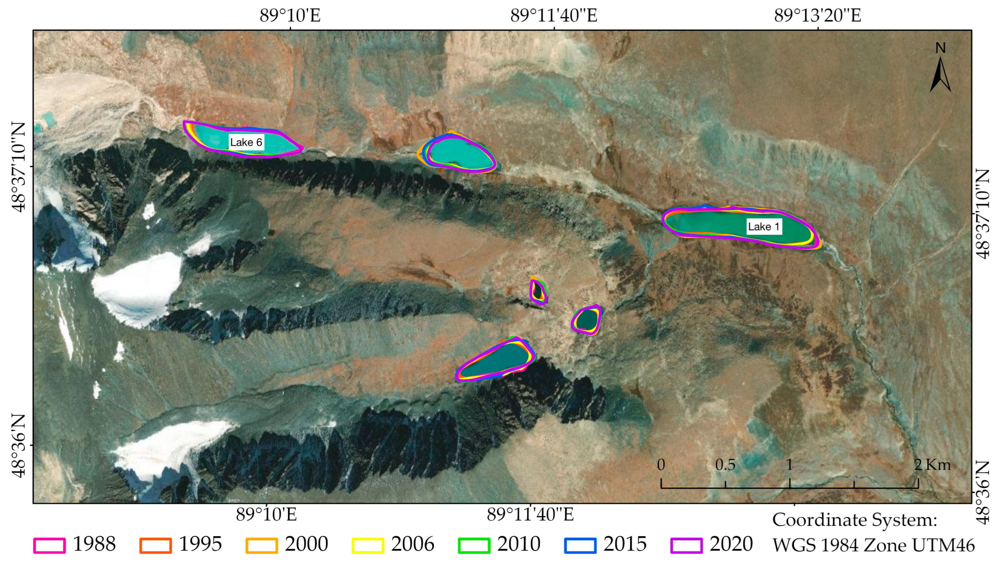
5.1. Tsengel Khairkhan Lakes, Tsengel Sum

Three tongue-basin lakes exist in a larger east-facing valley south of Tsengel Khairkhan Uul (2825 m asl.) in Tsengel Sum, Ulgii Aimag (Figure 9 and Figure 10). The elongated paternoster lakes are situated at 2683 m asl., 2760 m asl., and 2825 m asl. and reach up to one of the largest glaciers of the mountain range. Since the LGM, the glacier has retreated by more than 20 km. An active rock glacier separates the middle from the upper lake.

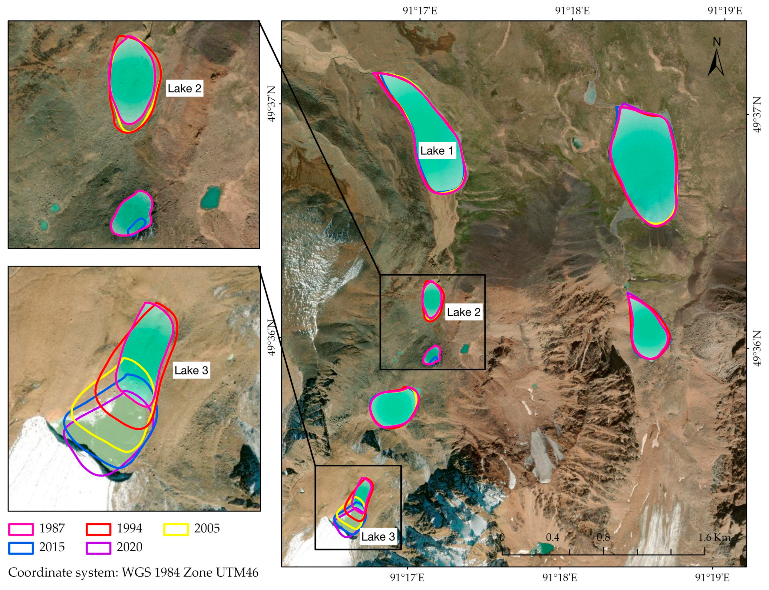
5.2. Rhashant Gol Lakes, Kharkhiraa Mountains

Multiple tongue-basin lakes exist in the Rhashant Gol in Khovd Sum, Uvs Aimag (Figure 11). The deepest one of a paternoster series, Rhashant Nuur (Lake 1), has an elongated shape and three sub-basins, representing a three-step glacier recession (Figure 12). While the northern and southern basins are up to 25 m deep and represent valuable sediment traps for future drilling explorations, the center basin is less than 20 m deep. The lower end is bordered by an impressive terminal moraine, and the northeast and southwest sides are flanked by lateral moraines covered with large blocks.
In 2012, a larger rockslide that was presumably caused by an earthquake triggered a glacial lake outburst flood (GLOF) at Lake 2 in Rhashant Gol and almost completely drained the lake (Figure 11; the underlying satellite image is from before 2012 and, hence, displays Lake 2 before the GLOF event). Figure 13 shows the rockslide deposit and the leaked Lake 2. The GLOF threatened the local nomads in the downstream valley.

6. Ice-Contact Lakes

Lakes that are in direct contact with an active glacier margin are relatively rare in the Mongolian Altai. However, one lake in the Munkh Khairkhan Mountains and a second one in the Kharkhiraa Mountains were visited in this study. Environmental information from the lake sediments is of value in understanding climate-controlled melting behavior of glaciers, as the seasonal cycle is reflected in different sediment layers, the so-called varves.
Ice-contact lakes have their own dynamics (Figure 14). They are in direct contact with a glacier ice front that thaws relatively quickly due to the excess heat of the meltwater. This thermo-mechanical melting process results in frequent glacier calving. In contrast, the ground ice in the surroundings that is widely covered by morainic debris of varying thicknesses melts at a slower rate. The steeper slopes of the coarse-block moraines are characterized by solifuidal processes such as offset denudation.

6.1. Munkh Khairkhan Lake 4, Munkh Khairkhan Mountains

A series of four paternoster lakes reaches down on the northern side of the Munkh Khairkhan Mountains, Khovd Aimag. Of these, Lake 4 (3190 m asl.) currently has ice contact and has significantly increased in area from 0.45 km2 in 1988 to 0.97 km2 in 2020, mainly as the result of the glacier recession (Figure 15). Interruptions in this process occurred from 2000 to 2005 and from 2010 to 2015. The lake level was relatively high in 2009, when the glacier still reached down from the main peak and ran over the pass (Figure 16). By 2021, the glacier had receded and left the pass area ice-free, while the lake level had significantly dropped.

6.2. Rhashant Gol Lake 3, Kharkhiraa Mountains

In Rhashant Gol in the Kharkhiraa Mountains, Khovd Sum, the uppermost lake, Lake 3, has ice contact. Between 1987 and 2020, its area increased from 0.28 km2 to 0.45 km2, with a phase of shrinkage between 2000 and 2009.

7. Endorheic Lakes

Khar Us Nuur (1157 m asl.) 30 km east of Khovd, the capital of Khovd Aimag, is situated in the Great Lakes Depression of western Mongolia. This endorheic lake is 72 km long and 36 km wide, and has an area of 1578 km2 and an average depth of only >2 m, with a maximum depth of 5 m. Khovd Gol is the largest river basin in western Mongolia and connects to numerous glaciers in the Altai Mountains.
Uvs Nuur (759 m asl.) in northwestern Mongolia is a highly saline, shallow endorheic lake, whose northeastern tip is in Russia. The lake is Mongolia’s largest, with a length of 84 km and a width of 79 km, covering an area of around 3350 km2 with an average depth of 6 m. It serves as a storage for Pleistocene and current meltwater from glaciers in the Turgen–Kharkhiraa Mountains in the west and the Khangai Mountains in the east [14,17]. Tsetseg Nuur in Khovd Aimag is the terminal lake for Sutai Uul Glacier [88,89].
Endorheic lakes can also be found in Buyant Gol, Tsagaan Gol, the Tavan Bogd Mountains, and some tributaries at Tsambagarav Mountain.

8. Discussion

In the Mongolian mountains, levels of glacial lakes were higher than today during the Holocene. Early Holocene paleoshorelines at more than 20 m above recent levels were found at Khar Nuur [16], Uvs Nuur, and Bayan Nuur [17,18,19]. At many other lakes, paleoshorelines at 5–8 m above recent levels date back to 7000–5000 years BP [19,61,90]. Since then, lakes levels generally dropped until recently, with the onset of the climate change-driven glacier recession that has resulted in lake-level rises and area expansion at almost all moraine-dammed, tongue-basin, and ice-contact lakes (Figure 17). This relatively rapid expansion of glacial lakes has also been noticed in other mountains, e.g., the Central Himalayas [91]. The increase in stored freshwater volume could be interpreted as beneficial to managing water resources. However, while the glacier recession indeed first adds to water availability for some years, the discharge will significantly decrease when the glaciers retreat to higher elevations, where they continue to exist only as remnants without significant meltwater production [26]. Hence, Integrated Water Resources Management (IWRM) must include the monitoring of glacial lakes and modeling of future climate—glacier—glacial lake relationships [92].
In contrast, endorheic lakes in mountains have mainly been shrinking for the past forty years. Reasons for this trend include an increase in air temperature, followed by higher evaporation rates and effects of intensifying water use within the catchment for irrigation, mining, and hydroelectric energy production in the form of dams. At Khar Us Nuur, reed beds are reaching increasingly farther into the lake, as the growing conditions, particularly water depth, have changed. Uvs Nuur is an exception, as it shows a weak trend of lake-level rise. An explanation could be its more northern location at the border to Siberia, where precipitation rates are higher, and a low human impact because of its high salinity.
Tao et al. (2015) [93] carried out a multi-temporal change analysis based on both satellite imagery and ground-based censuses of lakes of all types (not only glacial ones) of larger than 1 km2 on the Mongolian Plateau, which embraces Inner Mongolia of China and Mongolia. They found a rapid loss of lakes between the late 1980s and 2010, during which the number of lakes decreased by 34% in Inner Mongolia, where 145 lakes disappeared, and 17.6% in Mongolia, where 63 lakes disappeared. While the total lake area decreased by 30.3% in Inner Mongolia, it decreased by 2.4% in Mongolia. The authors identified decreasing precipitation as the driving factor in Mongolia, while it was coal mining and irrigation in Inner Mongolia.

9. Conclusions

The lakes of Mongolia are relatively poorly studied and deserve more attention. Their sediments represent rich archives of regional environmental developments, such as climate and vegetation changes. While drilling in remote mountain lakes is challenging considering the logistical realities and environmental conditions, it promises valuable research opportunities. In addition to this paleolimnological focus, monitoring lake area and water quality helps to assess socioeconomic impacts on water resources and, in the case of ice-dammed lakes, GLOF hazards. As recent temperatures across the Mongolian Altai increased at a rate above the global mean and glaciers are melting relatively fast, projections of future meltwater contributions to the replenishment of lakes are essential for water management strategies. Therefore, the creation of a lake monitoring system based on an in-depth inventory is recommended.
Monitoring lake changes and related impacts on ecosystems, agriculture, animal husbandry, and hydropower generation should go together with weather monitoring. The pace at which meltwater availability changes depends mainly on air and soil temperatures, as well as precipitation. In the extreme continental climate of Mongolia, precipitation is relatively local, and volumes can vary from low to high within short distances. In the Altai Mountains, heavy rainfall is not uncommon, and it enhances glacier melting. Therefore, a weather station network must pay attention to this small-scale pattern and must include sites near glaciers and glacial lakes. Finally, many of the high-elevation lakes are also fed by permafrost meltwater. While Mongolia has a long tradition of permafrost research, the impact of permafrost thawing on lake evolution is almost unknown.
The need for a lake monitoring system, improved weather station network, new directions in permafrost studies, and studies on the impacts of lake changes on socioeconomic developments calls for interdisciplinary research.

Author Contributions

M.W. and U.K.—conceptualization and writing; M.W. and N.-O.N.—visualization; M.W., N.-O.N., A.D. and K.T.—fieldwork. All authors have read and agreed to the published version of the manuscript.

Funding

This research received no external funding.

Data Availability Statement

The data presented in this study are available on request from the corresponding author. The data are not publicly available due to ongoing research.

Conflicts of Interest

The authors declare no conflict of interest.

References

  1. Wang, X.; Siegert, F.; Zhou, A.; Franke, J. Glacier and glacial lake changes and their relationship in the context of climate change, Central Tibetan Plateau 1972–2010. Glob. Planet. Change 2013, 111, 246–257. [Google Scholar] [CrossRef]
  2. Luo, W.; Zhang, G.; Chen, W.; Xu, F. Response of glacial lakes to glacier and climate changes in the western Nyainqentanglha range. Sci. Total Environ. 2020, 735, 139607. [Google Scholar] [CrossRef] [PubMed]
  3. Demberel, O.; Munkhbat, B.; Dorjsuren, B.; Callaghan, T.V.; Tsogoo, B.; Zemtsov, V.A.; Shaarav, O.; Gongor, E.; Jargalsaikhan, Z.; Ganhuyag, N.; et al. Relationship between dynamics of modern glaciers of the Mt. Munkhkhairkhan (Mongolian Altai) and climate. Water 2023, 15, 1921. [Google Scholar] [CrossRef]
  4. Khadka, N.; Chen, X.; Sharma, S.; Shrestha, B. Climate change and its impacts on glaciers and glacial lakes in Nepal Himalayas. Reg. Environ. Change 2023, 23, 143. [Google Scholar] [CrossRef]
  5. Larsen, C.F.; Burgess, E.; Arendt, A.; O’Neel, S.; Johnson, A.J.; Kienholz, C. Surface melt dominates Alaska glacier mass balance. Geophys. Res. Lett. 2015, 42, 5902–5908. [Google Scholar] [CrossRef]
  6. Shugar, D.H.; Burr, A.; Haritashya, U.K.; Kargel, J.S.; Watson, C.S.; Kennedy, M.C.; Bevington, A.R.; Betts, R.A.; Harrison, S.; Strattman, K. Rapid worldwide growth of glacial lakes since 1990. Nat. Clim. Change 2020, 10, 939–945. [Google Scholar] [CrossRef]
  7. Shrestha, B.; Mool, P.K.; Bajracharya, S.R. Impact of Climate Change on Himalayan Glaciers and Glacial Lakes: Case Studies on GLOF and Associated Hazards in Nepal and Bhutan; ICIMOD: Kathmandu, Nepal, 2007. [Google Scholar]
  8. Harrison, S.; Kargel, J.S.; Huggel, C.; Reynolds, J.; Shugar, D.H.; Betts, R.A.; Emmer, A.; Glasser, N.; Haritashya, U.K.; Klimeš, J.; et al. Climate change and the global pattern of moraine-dammed glacial lake outburst floods. Cryosphere 2018, 12, 1195–1209. [Google Scholar] [CrossRef]
  9. Nie, Y.; Liu, Q.; Wang, J.; Zhang, Y.; Sheng, Y.; Liu, S. An inventory of historical glacial lake outburst floods in the Himalayas based on remote sensing observations and geomorphological analysis. Geomorphology 2018, 308, 91–106. [Google Scholar] [CrossRef]
  10. Ahmed, R.; Wani, G.F.; Ahmad, S.T.; Sahana, M.; Singh, H.; Ahmed, P. A review of glacial lake expansion and associated glacial lake outburst floods in the Himalayan region. Earth Syst. Environ. 2021, 5, 695–708. [Google Scholar] [CrossRef]
  11. Liu, Z.; Yang, Z.; He, N.; Wei, L.; Zhu, Y.; Jiao, W.; Wang, Z.; Zhang, T.; Zhang, J.; Zou, X. Three decades of glacial lake research: A bibliometric and visual analysis of glacial lake identification. Front. Ecol. Evol. 2023, 11, 1296111. [Google Scholar] [CrossRef]
  12. National Office of Statistics. Yearbook 2016; National Office of Statistics: Ulaanbaatar, Mongolia, 2016. (In Mongolian) [Google Scholar]
  13. Baldandorj, T. Water Resource and Its Appropriate Usage; Munkhiin Useg: Ulaanbaatar, Mongolia, 2017; Volume II. (In Mongolian) [Google Scholar]
  14. Walther, M. Paleoenvironmental changes in the Uvs Nuur basin (Northwest Mongolia). Explor. Into Biol. Resour. Mong. 2010, 11, 267–280. [Google Scholar]
  15. Walther, M.; Enkhjargal, V.; Gegeensuvd, T.; Odbaatar, E. Environmental changes of Orog Nuur (Bayan Khongor Aimag, south Mongolia): Lake deposits, paleo-shorelines and vegetation history. Explor. Into Biol. Resour. Mong. 2016, 13, 37–57. [Google Scholar]
  16. Walther, M.; Dashtseren, A.; Kamp, U.; Temujin, K.; Meixner, F.; Pan, C.G.; Gansukh, Y. Glaciers, permafrost and lake levels at Tsengel Khairkhan Massif, Mongolian Altai, during the Late Pleistocene and Holocene. Geosciences 2017, 7, 73. [Google Scholar] [CrossRef]
  17. Walther, M.; Horn, W.; Dashtseren, A. Uvs Nuur: A sentinel for climate change in eastern Central Asia. In Large Asian Lakes in a Changing World; Mischke, S., Ed.; Springer: New York, NY, USA, 2020; pp. 235–257. [Google Scholar]
  18. Naumann, S.; Walther, M. Mid-Holocene lake level fluctuations of Bajan Nuur (NW Mongolia). Marbg. Geogr. Schriften 2000, 135, 15–27. [Google Scholar]
  19. Grunert, J.; Lehmkuhl, F.; Walther, M. Paleoclimatic evolution of the Uvs Nuur basin and adjacent areas (Western Mongolia). Quat. Int. 2000, 65/66, 171–192. [Google Scholar] [CrossRef]
  20. Navchaa, T. Hydrography of Mongolia. In The Physical Geography of Mongolia; Batchuluun, Y., Ed.; Springer Nature: Bern, Switzerland, 2021; pp. 77–100. [Google Scholar]
  21. Chen, F.; Zhang, M.; Guo, H.; Allen, S.; Kargel, J.S.; Haritashya, U.K.; Watson, C.S. Annual 30 m dataset for glacial lakes in High Mountain Asia from 2008 to 2017. Earth Syst. Sci. Data 2021, 13, 741–766. [Google Scholar] [CrossRef]
  22. Kamp, U.; Krumwiede, B.S.; McManigal, K.G.; Pan, C.G.; Walther, M.; Dashtseren, A. The glaciers of Mongolia. Inst. Arct. Alp. Res. (INSTAAR) Occas. Pap. 2013, 61, 48p. [Google Scholar]
  23. Kamp, U.; Pan, C.G. Inventory of glaciers in Mongolia, derived from Landsat imagery from 1989 to 2011. Geogr. Ann. Ser. A Phys. Geogr. 2015, 97, 653–669. [Google Scholar] [CrossRef]
  24. Pan, C.G.; Pope, A.; Kamp, U.; Dashtseren, A.; Walther, M.; Syromyatina, M.V. Glacier recession in the Altai Mountains of Mongolia in 1990-2016. Geogr. Ann. Ser. A Phys. Geogr. 2017, 100, 185–203. [Google Scholar] [CrossRef]
  25. Davaa, G. Climate Change Impacts on Water Resources in Mongolia; Institute of Water and Meteorology: Ulaanbaatar, Mongolia, 2010. [Google Scholar]
  26. Pan, C.G.; Kamp, U.; Munkhjargal, M.; Halvorson, S.J.; Dashtseren, A.; Walther, M. Understanding the contribution and importance of glaciers to regional hydrology in Mongolia’s Altai Mountains. Mt. Res. Dev. 2019, 39, 12–20. [Google Scholar]
  27. Tsedevdorj, S.-O. Glaciers of Mongolia. In The Physical Geography of Mongolia; Batchuluun, Y., Ed.; Springer Nature: Bern, Switzerland, 2021; pp. 101–117. [Google Scholar]
  28. Dashtseren, A. Permafrost of Mongolia. In The Physical Geography of Mongolia; Batchuluun, Y., Ed.; Springer Nature: Bern, Switzerland, 2021; pp. 119–133. [Google Scholar]
  29. Kamp, U.; Walther, M.; Dashtseren, A. Mongolia’s cryosphere. Geomorphology 2022, 410, 108202. [Google Scholar] [CrossRef]
  30. Walther, M.; Kamp, U. Mountain permafrost: A reflection on the periglacial environment in Mongolia. Geosciences 2023, 13, 274. [Google Scholar] [CrossRef]
  31. Orkhonselenge, A.; Uuganzaya, M.; Davaagatan, T. Lakes of Mongolia: Geomorphology, Geochemistry and Paleoclimatology; Springer: Cham, Switzerland, 2022. [Google Scholar]
  32. Enkhbold, A.; Khukhuudei, U.; Doljin, D. A review of modern trends and historical stages of development of lake research in Mongolia. Proc. Mong. Acad. Sci. 2022, 62, 25–37. [Google Scholar] [CrossRef]
  33. Klinge, M.; Sauer, D. Spatial pattern of Late Glacial and Holocene climatic and environmental development in Western Mongolia—A critical review and synthesis. Quaternay Sci. 2019, 210, 26–50. [Google Scholar] [CrossRef]
  34. Khenzykhenova, F.; Dorofeyuk, N.; Shchetnikov, A.; Danukalova, G.; Bazarova, V. Palaeoenvironmental and climatic changes during the late Glacial and Holocene in the Mongolia and Baikal region: A review. Quat. Int. 2021, 605/606, 300–328. [Google Scholar] [CrossRef]
  35. Kondratiev, S. Telmen-Nur and West of Hangai plateau. Econ. Mong. 1929, 11–16. (In Russian) [Google Scholar]
  36. Smirnov, V. Report on the works of the hydro-chemical group of the Mongolian expedition in 1926. Proc. Mong. Comm. 1932, 1, 1–23. (In Mongolian) [Google Scholar]
  37. Murzaev, E.M. The Mongolian People’s Republic: A Physical-geographical Description; State Publication of Geographical Literature: Moscow, Russia, 1948. (In Russian) [Google Scholar]
  38. Kuznetsov, N.T. To the question about water exchange between the lakes in the Depression of the Great Lakes in Mongolia. News Acad. Sci. USSR Geogr. Geophys. Ser. 1951, 5, 272. (In Russian) [Google Scholar]
  39. Tsegmid, S. 1955. From the past of the Valley of Lakes in the Mongolian Gobi. Natura 1955, 5, 46–49. [Google Scholar]
  40. Dashdorzh, A. 1973. Materials on fauna of Lake Huvsgul. Stud. Inst. Biol. Mong. Acad. Sci. 1973, 8, 108–112. (In Mongolian) [Google Scholar]
  41. Tserensodnom, J. Lakes of Mongolia; State Publishing: Ulaanbaatar, Mongolia, 1971. (In Mongolian) [Google Scholar]
  42. Tserensodnom, J. A Catalogue of Lakes in Mongolia; Shuvuum Saaral Publishing: Ulaanbaatar, Mongolia, 2000. [Google Scholar]
  43. Martinson, G.G. Mezozoic Lake Depressions of Mongolia; Nauka: Leningrad, Russia, 1982. (In Russian) [Google Scholar]
  44. Sevastyanov, D.V.; Dorofeyk, N.I. Lakes of the Mongolian People’s Republic and Their Mineral Resources; Nauka: Moscow, Russia, 1991. (In Russian) [Google Scholar]
  45. Dulmaa, A. Hydrobiology of Darkhad Lake Basin; Mongolian Academy of Sciences: Ulaanbaatar, Mongolia, 1964. (In Mongolian) [Google Scholar]
  46. Kozhov, M.M. Lake Huvsgul and Opportunities for Its Fish Supply Utilization. Irkutsk, Russia. 1965. (In Russian) [Google Scholar]
  47. Dulmaa, A.; Nansalmaa, B.; Bullion, V. Natural Conditions and Resources of Lake Huvsgul in the Mongolian People’s Republic; Nauka: Moscow, Russia, 1976. (In Russian) [Google Scholar]
  48. Sokolov, V.E. Flora and Fauna of Mongolia; Nauka: Moscow, Russia, 1978. (In Russian) [Google Scholar]
  49. Sokolov, V.E. Fishes of the Mongolian People’s Republic; Nauka: Moscow, Russia, 1983. (In Russian) [Google Scholar]
  50. Sokolov, V.E. Ecology and Economical Potential of the Fishes of Mongolian People’s Republic; Nauka: Moscow, Russia, 1985. (In Russian) [Google Scholar]
  51. Avirmed, A. Analysis of the salt composition of Lake Devter. Trans. Inst. Chem. Acad. Sci. 1959, 3/4, 42–52. (In Mongolian) [Google Scholar]
  52. Sokolov, V.E. Structure and Dynamics of Basic Ecosystems of the Mongolian People’s Republic; Nauka: Moscow, Russia, 1976. (In Russian) [Google Scholar]
  53. Sokolov, V.E.; Shagdarsuren, O. Natural Conditions, Vegetative Cover and Fauna of Mongolia; Puschino Scientific Centre for Biological Research of the Russian Academy of Sciences: Moscow, Russia, 1988. (In Russian) [Google Scholar]
  54. Sevastyanov, D.; Shuvalov, V.; Neustrueva, Y. Limnology and Paleolimnology of Mongolia; Nauka: St. Petersburg, Russia, 1994. (In Russian) [Google Scholar]
  55. Tarasov, P.E.; Pushenk, M.Y.; Harrison, S.P.; Saarse, L.; Andreev, A.A.; Aleshinskaya, Z.V.; Davydova, N.N.; Dorofeyuk, N.I.; Efremov, Y.V.; Elina, G.A.; et al. Lake Status Records from the Former Soviet Union and Mongolia. Documentation of the Second Version of the Data Base; World Data Center-A for Paleoclimatology, NOAA-NGDC Paleoclimatology Program: Boulder, CO, USA, 1996; Volume 5. [Google Scholar]
  56. Tarasov, P.E.; Webb III, T.; Andreev, A.A.; Afanaseva, N.B.; Berezina, N.A.; Bezusko, L.G.; Blyakharchuk, T.A.; Bolikhovskaya, N.S.; Cheddadi, R.; Chernavskaya, M.M.; et al. Present-day and mid-Holocene Biomes Reconstructed from Pollen and Plant Macrofossil Data from the Former Soviet Union and Mongolia. J. Biogeogr. 1998, 25, 1029–1053. [Google Scholar] [CrossRef]
  57. Rudaya, N.; Tarasov, P.; Dorofeyuk, N.; Solovieva, N.; Kalugin, I.; Andreev, A.; Daryin, A.; Diekmann, B.; Riedel, F.; Narantsetseg, T.; et al. Holocene environments and climate in the Mongolian Altai reconstructed from the Hoton-Nur pollen and diatom records: A step towards better understanding climate dynamics in Central Asia. Quat. Sci. Rev. 2009, 28, 540–554. [Google Scholar] [CrossRef]
  58. Sevastyanov, D.V.; Dorofeyk, N.I. A short review: Limnological and paleolimnological research in Mongolia carried out by Joint Russian-Mongolian expeditions. J. Mt. Sci. 2005, 2, 86–90. [Google Scholar] [CrossRef]
  59. Krengel, M. Discourse on history of vegetation and climate in Mongolia: Palynological report of sediment core Bayan Nuur I (NW-Mongolia). Berl. Geowiss. Abh. 2000, 205, 80–84. [Google Scholar]
  60. Peck, J.A.; Khosbayar, P.; Fowell, S.J.; Pearce, R.B.; Ariunbileg, S.; Hansen, B.C.S.; Soninkhishig, N. Mid to Late Holocene climate change in north central Mongolia as recorded in the sediments of Lake Telmen. Palaeogeogr. Palaeoclimatol. Palaeoecol. 2002, 83, 135–153. [Google Scholar] [CrossRef]
  61. Fowell, S.J.; Hansen, B.C.S.; Peck, J.A.; Khosbayar, P.; Ganbold, E. Mid to late Holocene climate evolution of the Lake Telmen basin, North Central Mongolia, based on palynological data. Quat. Res. 2003, 59, 353–363. [Google Scholar] [CrossRef]
  62. Sonninkhishig, N.; Walther, M.; Tungalag, K. A new record of relative diatom abundance from Ugii Nuur, Central Mongolia, and possible climatic inferences. Geogr. Oekologica 2005, 3, 35–41. [Google Scholar]
  63. Dorofeyuk, N.I. Reconstruction of Nature Conditions of Central Asia in Late Glacial and Holocene (Material of Diatom and Palinological Analyses of Lake Sediments of Mongolia). Ph.D. Thesis, Irkutsk University, Moscow, Russia, 2008. (In Russian). [Google Scholar]
  64. Schwanghart, W.; Frechen, M.; Kuhn, N.J.; Schütt, B. Holocene environmental changes in the Ugii Nuur basin, Mongolia. Palaeogeogr. Palaeoclimatol. Palaeoecol. 2009, 279, 160–171. [Google Scholar] [CrossRef]
  65. Wang, W.; Ma, Y.; Feng, Z.; Narantsetseg, T.; Liu, K.B.; Zhai, X. A prolonged dry mid-Holocene climate revealed by pollen and diatom records from Lake Ugii Nuur in central Mongolia. Quat. Int. 2011, 229, 74–83. [Google Scholar] [CrossRef]
  66. Amgalan, M.; Matsumoto, T.; Altanbold, E.; Nandintsetseg, N. Application of Remote Sensing and GIS Techniques for the Analysis of Lake Water Fluctuations: A Case Study of Ugii Lake, Mongolia. Nat. Environ. Pollut. Technol. 2021, 20 (Suppl. 5), 2051–2059. [Google Scholar]
  67. Struck, J.; Bliedtner, M.; Strobel, P.; Taylor, W.; Biskop, S.; Plessen, B.; Klaes, B.; Bittner, L.; Bayarsaikhan, J.; Salazar, G.; et al. Central Mongolian lake sediments reveal new insights on climate change and equestrian empires in the Eastern Steppes. Sci. Rep. 2022, 12, 2829. [Google Scholar] [CrossRef] [PubMed]
  68. Krivonogov, S.K.; Bezrukova, E.V.; Takahara, H.; Riedel, F. The Hovsgol Lake in the Late Pleistocene and Holocene: On-land geologic evidence for the change of its level. In Long Continental Records from Lake Baikal; Kashivaya, K., Ed.; Springer: Tokyo, Japan, 2003; pp. 187–206. [Google Scholar]
  69. Fedotov, A.P.; Kazansky, A.Y.; Tomurhuu, D.; Matasova, G.G.; Ziborova, G.A.; Zheleznyakova, T.O.; Vorobyova, S.S.; Phedorin, M.A.; Goldberg, E.L.; Oyunchimeg, T.S.; et al. A 1 My record of paleoclimates from lake Khubsugul, Mongolia. EOS Trans. 2004, 85, 387–390. [Google Scholar] [CrossRef]
  70. Fedotov, A.P.; Chebykin, E.P.; Semenov, M.Y.; Vorobyova, S.S.; Osipov, E.Y.; Golobokova, L.P.; Pogodaeva, T.V.; Zheleznyakova, T.O.; Grachev, M.A.; Tomurhuu, D.; et al. Changes in the volume and salinity of Lake Khubsugul (Mongolia) in response to global climate changes in the upper Pleistocene and the Holocene. Palaeogeogr. Palaeoclimatol. Palaeoecol. 2004, 209, 245–257. [Google Scholar] [CrossRef]
  71. Krivonogov, S.K.; Sheinkman, V.; Mistruykov, A.A. Stages in the development of the Darhad dammed lake (Northern Mongolia) during the Late Pleistocene and Holocene. Quat. Int. 2005, 156, 83–94. [Google Scholar] [CrossRef]
  72. Prokopenko, A.A.; Kuzmin, M.I.; Williams, D.F.; Gelety, V.F.; Kalmychkov, G.V.; Gvozdkov, A.N.; Solotchin, P.A. Basin-wide sedimentation changes and deglacial lake-level rise in Lake Hovsgol basin, NW Mongolia. Quat. Int. 2005, 136, 59–69. [Google Scholar] [CrossRef]
  73. Krivonogov, S.K. Late Cenozoic history of Lake Hovsgol area. In The Geology, Biodiversity and Ecology of Lake Hovsgol (Mongolia); Goulden, C.E., Sitnikova, T., Gelhaus, J., Bazartseren, B., Eds.; Backhuys Publishers: Leiden, The Netherlands, 2006; pp. 21–40. [Google Scholar]
  74. Fedotov, A.P.; Phedorin, M.A.; De Batist, M.; Ziborova, G.A.; Kazansky, A.Y.; Semenov, M.Y.; Matasova, G.G.; Khabuev, A.V.; Kugakolov, S.A.; Rodyakin, S.V.; et al. A 450-ka long record of glaciation in northern Mongolia based on studies at Lake Khubsugul: High-resolution reflection seismic data and grain-size variations in cored sediments. J. Paleolimnol. 2007, 39, 335–348. [Google Scholar] [CrossRef]
  75. Prokopenko, A.A.; Khursevich, G.K.; Bezrukova, E.V.; Kuzmin, M.I.; Boes, X.; Williams, D.F.; Fedenya, S.A.; Kulagina, N.V.; Letunova, P.P.; Abzaeva, A.A. Paleoenvironmental proxy records from Lake Hovsgol, Mongolia, and a synthesis of Holocene climate change in the Lake Baikal watershed. Quat. Res. 2007, 68, 2–17. [Google Scholar] [CrossRef]
  76. Gillespie, A.R.; Burke, R.M.; Komatsu, G.; Bayasgalan, A. Late Pleistocene glaciers in Darhad Basin, northern Mongolia. Quat. Res. 2008, 69, 169–187. [Google Scholar] [CrossRef]
  77. Hovsgol Drilling Project Members. Sedimentary record from Lake Hovsgol, NW Mongolia: Results from the HDP-04 and HDP-06 drill cores. Quat. Int. 2009, 205, 21–37. [Google Scholar] [CrossRef]
  78. Krivonogov, S.K.; Yi, S.; Kasjiwaya, K.; Kim, J.C.; Narantsetseg, T.; Oyunchimeg, T.; Safonova, I.Y.; Kazansky, A.Y.; Sitnikova, T.; Kim, J.Y.; et al. Solved and unsolvesd problems of sedimentation, glaciation and paleolakes of the Darhad Basin, Northern Mongolia. Quat. Sci. Rev. 2012, 56, 142–163. [Google Scholar] [CrossRef]
  79. Kumagai, M.; Urabe, J.; Goulden, C.E.; Soninkhishig, N.; Hadbaatar, D.; Tsujimura, S.; Hayami, Y.; Sekino, T.; Maruo, M. Recent rise in water level at Lake Hovsgol, Mongolia. In The Geology, Biodiversity and Ecology of Lake Hovsgol (Mongolia); Goulden, C.E., Sitnikova, T., Gelhaus, J., Bazartseren, B., Eds.; Backhuys Publishers: Leiden, The Netherlands, 2006; pp. 77–92. [Google Scholar]
  80. Watanabe, T.; Nakamura, T.; Nara, F.W.; Kakegawa, T.; Horiuchi, K.; Senda, R.; Oda, T.; Nishimura, M.; Matsumoto, G.I. High-time resolution AMS 14C data sets for Lake Baikal and Lake Hovsgol sediment cores: Changes in radiocarbon age and sedimentation rates during the transition from the last glacial to the Holocene. Quat. Int. 2009, 205, 12–20. [Google Scholar] [CrossRef]
  81. Kashiwaya, K.; Ochiai, S.; Sumino, G.; Tsukamoto, T.; Szyniszewska, A.; Yamamoto, M.; Sakaguchi, A.; Hasebe, N.; Sakai, H.; Watanabe, T.; et al. Climato-hydrological fluctuations printed in long lacustrine records in Lake Hovsgol, Mongolia. Quat. Int. 2010, 219, 178–187. [Google Scholar] [CrossRef]
  82. Watanabe, T.; Minoura, K.; Watanabe Nara, F.; Shichi, K.; Horiuchi, K.; Kakegawa, T.; Kawai, T. Last glacial to post glacial climate changes in continental Asia inferred from multi-proxy records (geochemistry, clay mineralology, and paleontology) from Hovsgol, northwest Mongolia. Glob. Planet. Change 2012, 88/89, 53–63. [Google Scholar] [CrossRef]
  83. Orkhonselenge, A.; Krivonogov, S.K.; Mino, K.; Kashiwaya, K.; Yamamoto, M.; Nakamura, T. Holocene landform evolution of Lake Khuvsgol basin, Mongolia. Géormorphologie: Relief Process. Eviron. 2014, 4, 343–354. [Google Scholar] [CrossRef]
  84. Klinge, M.; Schlütz, F.; Zander, A.; Hülle, D.; Batkhishig, O.; Lehmkuhl, F. Late Pleistocene lake level, glaciation and climate change in the Mongolian Altai deduced from sedimentological and palynological archives. Quat. Res. 2020, 99, 168–189. [Google Scholar] [CrossRef]
  85. Lehmkuhl, F.; Grunert, J.; Hülle, D.; Batkhishig, O.; Stauch, G. Paleolakes in the Gobi region of southern Mongolia. Quat. Sci. Rev. 2018, 179, 1–23. [Google Scholar] [CrossRef]
  86. Udaanjargal, U.; Hasebe, N.; Davaasuren, D.; Fukushi, K.; Tanaka, Y.; Gankhurel, B.; Katsuta, N.; Ochiai, S.; Miyata, Y.; Gerelmaa, T. Characteristics of lake sediment from southwestern Mongolia and comparison with meteorological data. Geosciences 2022, 12, 7. [Google Scholar] [CrossRef]
  87. Krumwiede, B.S.; Kamp, U.; Leonard, G.J.; Dashtseren, A.; Walther, M. Recent glacier changes in the Altai Mountains, western Mongolia: Case studies from Tavan Bogd and Munkh Khairkhan. In Global Land Ice Measurements from Space: Satellite Multispectral Imaging of Glaciers; Kargel, J.S., Bishop, M.P., Kääb, A., Raup, B., Eds.; Springer: Berlin/Heidelberg, Germany, 2014; pp. 481–508. [Google Scholar]
  88. Klinge, M. Glacio-geomorphological studies in the Mongolian Altai as a contribution to the Late Quaternary landscape and climate history in western Mongolia. Aachen. Geogr. Arb. 2001, 35. (In German) [Google Scholar]
  89. Klinge, M.; Lehmkuhl, F. Geomorphology of the Tsetseg Nuur basin, Mongolian Altai—A lake development, fluvial sedimentation, and aeolian transport in a semi-arid environment. J. Maps 2013, 9, 361–366. [Google Scholar] [CrossRef]
  90. Dorofeyuk, N.I.; Tarasov, P.E. Vegetation and lake levels of northern Mongolia since 12,500 yr B.P. based on the pollen and diatom records. Stratigr. Geol. Correl. 1998, 6, 70–83. [Google Scholar]
  91. Wang, W.; Xiang, Y.; Gao, Y.; Lu, A.; Yao, T. Rapid expansion of glacial lakes caused by climate and glacier retreat in the Central Himalayas. Hydrol. Process. 2015, 29, 859–874. [Google Scholar] [CrossRef]
  92. Orkhonselenge, A.; Harbor, J.M. Impacts of modern glacier changes on surface water resources in western and northern Mongolia. J. Water Resour. Prot. 2018, 10, 559–576. [Google Scholar] [CrossRef]
  93. Tao, S.; Fang, J.; Zhao, X.; Zhao, S.; Shen, H.; Hu, H.; Tang, Z.; Wang, Z.; Guo, Q. Rapid loss of lakes on the Mongolian Plateau. PNAS 2015, 112, 2281–2286. [Google Scholar] [CrossRef]
Figure 1. Locations of glacial lakes in western Mongolia covered in this study.
Geographies 04 00002 g001
Figure 2. Khar Nuur is dammed by a lateral moraine. Kettle holes (foreground) are a typical element of this formerly glaciated landscape. (Photo: M. Walther, August 2017).
Geographies 04 00002 g002
Figure 3. Oscillations of the level of Khar Nuur between 1988 and 2020. (From [16], modified).
Geographies 04 00002 g003
Figure 4. Former shorelines of Khar Nuur’s western bay. (Photo: M. Walther, August 2018).
Geographies 04 00002 g004
Figure 5. Ikh Hag Nuur (Lake 1) is dammed by a lateral moraine complex. The lake level oscillated between 1988 and 2020.
Geographies 04 00002 g005
Figure 6. Bathymetric map of Ikh Hag Nuur.
Geographies 04 00002 g006
Figure 7. Burideiin Nuur in Munkh Khairkhan National Park. (a) Location of the lake and Shuurkhai Gol in the Munkh Khairkhan Mountains; (b) paleoshorelines; (c) rhythmically laminated lake deposits. (Photos: M. Walther, August 2018).
Geographies 04 00002 g007
Figure 8. Bathymetric map of Burideiin Nuur in Munkh Khairkhan National Park.
Geographies 04 00002 g008
Figure 9. Tongue-basin lakes east of Tsengel Khairkhan Uul and shorelines between 1988 and 2020.
Geographies 04 00002 g009
Figure 10. Tongue-basin lake east of Tsengel Khairkhan Uul. (Photo: M. Walther, August 2017).
Geographies 04 00002 g010
Figure 11. Tongue-basin lakes in Rhashant Gol in the Kharkhiraa Mountains and shorelines between 1987 and 2020.
Geographies 04 00002 g011
Figure 12. Bathymetric map of tongue-basin lake Rhashant Nuur (Lake 1) in Rhashant Gol, Khakkhara Mountains.
Geographies 04 00002 g012
Figure 13. A rockslide, presumably caused by an earthquake, triggered a glacial lake outburst flood (GLOF) at Lake 2 in Rhashant Gol and almost completely drained the lake. (Photos: M. Walther, July 2017).
Geographies 04 00002 g013
Figure 14. The ice-contact environment has its own dynamics, like at Lake 4 in the Munkh Khairkhan Mountains. (Photo: M. Walther, August 2021).
Geographies 04 00002 g014
Figure 15. Lakes in the Munkh Khairkhan Mountains and shorelines between 1988 and 2020. Lake 4 is an ice-contact lake.
Geographies 04 00002 g015
Figure 16. Repeat photo pair of Lake 4 in the Munkh Khairkhan Mountains. (a) In 2009, the lake level was higher, and a glacier reaching down from the main peak still overflowed the pass; (b) in 2021, the lake level was significantly lower, and the pass was ice-free because of the receding glacier. (Photos: M. Walther, 2009, 2021).
Geographies 04 00002 g016
Figure 17. Changes in area of glacial lakes in Western Mongolia between 1987/1988 and 2020. (A) Khar Nuur; (B) Lake 4 at Munkh Khairkhan; (C) Lake 2 next to Ikh Hag Nuur (Lake 1); (D) Ikh Hag Nuur (Lake 1); (E) Lake 6 at Tsengel Khairkhan; (F) Lake 3 in Rhashant Gol.
Geographies 04 00002 g017
Disclaimer/Publisher’s Note: The statements, opinions and data contained in all publications are solely those of the individual author(s) and contributor(s) and not of MDPI and/or the editor(s). MDPI and/or the editor(s) disclaim responsibility for any injury to people or property resulting from any ideas, methods, instructions or products referred to in the content.

