1. Introduction
Augmented reality applications augment the real world with digital information. Augmented reality (AR) applications fall near the real side of the virtuality continuum, where real environments lie on one end and virtual environments on the other (
Figure 1). This space between the two ends contains various levels of mixing between virtual and real-world elements. This space is also known as mixed reality [
1].
There are mainly three forms of AR: marker-based, markerless and location-based. Maker-based AR (or image-based AR) works by scanning a marker that triggers an augmented experience. The marker can be a 2D image or a 3D object (a drawing in an art museum, a street sign, a statue, etc.) that activates digital content when it is seen through a mobile device’s camera or an AR head-mounted display. The digital layer of information that superimposes the real-world in AR applications can come in many multimedia forms, such as text, images, videos, sound, 3D models, and animations.
Markerless AR applications do not need a marker to activate the augmentations. In markerless AR, digital content is chosen by the users and overlaid on physical surfaces on demand (floor, table, etc.). Finally, location-based AR applications, which are the focus of this study, present digital media to users when they reach specific locations as they move through the physical world. The presentation of the digital media typically takes place through a mobile device (smartphone or tablet), and the tracking of the user’s position is accomplished through the GPS (global positioning system) sensors of the mobile device or the wireless network [
2,
3,
4].
AR location-based applications have existed for many years but became mainstream only recently after the advent of the popular AR location-based games Ingress and Pokemon Go, both created by Niantic in 2014 and 2016, respectively. Another term frequently used for these types of applications is location-aware AR.
Location-based AR applications are interactive media that have been greatly embraced in many sectors, such as tourism, entertainment, marketing, and education. These applications can also be used to fulfill more than one purpose. For example, a location-aware AR game can be used in the tourism sector to entertain and educate the visitors of a destination, simultaneously accomplishing the touristic destination’s marketing goals.
An AR experience can become even more compelling if it is combined with storytelling and gamification components. Storytelling is deeply embedded in human learning, as it provides an organizational structure for new experiences and knowledge [
5]. People can mentally organize information better when it is communicated through a story. Storytelling is fundamentally important in communication, and any advancements in media technology that enable people to tell stories in new and potentially more compelling ways can have a profound impact. Telling a story is also an important method of education and instruction. Stories can contain lessons, codified bits of wisdom that are passed on in a memorable and enjoyable form [
6].
Gamification, on the other hand, can positively impact the educational process, as it integrates game mechanisms and elements into teaching and learning activities. Game mechanics and elements can play a vital role in creating, motivating, and engaging learning experiences that have the potential to increase students’ academic performance [
7,
8,
9]
In education, location-based AR experiences (or location-aware AR) promote active learning, as students engage with a mobile interactive application and simultaneously move in the real world and explore their physical surroundings (e.g., [
10,
11]). With location-based mixed reality experiences, learners can obtain knowledge by visiting places of educational interest through informative digital content activated and displayed on their mobile devices when specific locations are reached. The learner’s location is tracked constantly through the mobile device’s GPS sensor, and the game’s scenario can occur in historical, cultural, and environmental interest areas. Location-based games increase learner satisfaction by adding excitement and stimulation to the learning process [
12].
Educators can organize scavenger hunts or create “learning experiences” by setting up geographical location points that must be visited in order for the digital content to be activated. According to many studies, educational tasks involving physical activity have proved to be efficient in learning [
13].
This study presents two location-based augmented-reality applications used for cultural heritage education, and more specifically, for educating the public about a prehistoric settlement, the prehistoric lake settlement of Dispilio in Kastoria. We also aim to provide ideas and guidance for those wishing to create applications for cultural heritage education, especially educators with limited or no programming experience. We attempt to accomplish this by proposing a suitable software tool for creating such applications and design elements that would make these applications more engaging and efficient. Furthermore, by presenting the two applications, we attempt to provide the educators with ideas on how to apply certain design decisions to applications (e.g., storytelling and gamification). Interactive storytelling and gamification, as mentioned, have great potential in the education and entertainment (edutainment) of visitors in places where cultural heritage is preserved (museums, archaeological sites, old city areas, etc.) [
14].
The research objectives of this study were the following:
RO1: To select a software tool that will be suitable for the development of the location-based applications, keeping in mind that among the study's goals was to provide ideas and guidance to educators interested in creating augmented reality experiences for cultural heritage education.
RO2: To determine the key aspects of the application design that would make a location-based AR experience for cultural heritage education successful and engaging.
RO3: To determine the method for evaluating the applications.
In this study, related work is presented in
Section 2, and information about the prehistoric lake settlement of Dispilio in Kastoria, is given in
Section 3. In
Section 4, the study’s methodology is described.
Section 5 discusses pre-production design considerations and presents the two applications in detail.
Section 6 describes a preliminary evaluation process, and
Section 7 presents the results of this evaluation. A discussion on the findings is in
Section 8, and the study concludes in
Section 9.
2. Related Work
AR has been utilized in all educational levels in early childhood education [
15], primary and secondary education, and higher education [
16]. It has also been utilized by various types of learners, such as adult learners, older adults, and students with special needs [
17]. AR has also been used to support a broad range of subjects, as seen in recent literature reviews, e.g., [
9]. The subjects include language learning [
18,
19], mathematics [
20,
21], chemistry [
22], computer science [
23,
24], engineering [
25], history [
26,
27], physics [
28], STEM subjects [
29,
30], and environmental science [
31].
The common conclusion of these research studies is that AR applications can enhance the learning process and increase the learner’s motivation, engagement, and effectiveness.
AR has also been utilized in cultural heritage education. AR technology is a valuable tool for strengthening the value of cultural heritage by enhancing a visitor’s experience and knowledge.
There are several examples of projects that use AR in the cultural heritage field. In [
32,
33], the researchers experimented with the use of augmented reality technology for indoor museums and outdoor archeological sites. The outcome of their research was AR applications able to transmit historical-archaeological content to a broad, non-specialized audience, through 3D virtual reconstructions. Users were able to visualize the reconstructions by pointing the cameras of their mobile phones toward photographs of the site, which were used as image targets.
The “virtual portals” offer new possibilities for outdoor archaeological sites [
34,
35] by incorporating transfers (or jumps) between AR and VR. Inspired by many series or movies and video games, the authors of [
24] explored the possibility of mixed reality applications that contain “shortcuts” for accomplishing “time travel” by using the concept of the virtual portal in order to bring the user from the real environment of the present to the virtual environment of the past.
The authors of [
36] attempted to teach primary and middle school children the cultural and historical importance of the walled cities of the Veneto region using AR technology.
By examining the scientific literature, it becomes evident that most AR projects employ marker-based AR. Location-based AR, which has significant potential in cultural heritage education, is also used, but to a smaller extent. Location-based AR (a subset of AR) can aid users in learning historical facts and other aspects of cultural heritage through tour explorations of urban environments, archeological sites, and museums.
In [
37], the authors developed a location-based AR mobile application, supporting the exploration of a given archaeological site from an aerial perspective, by exploiting unmanned aerial vehicles (UAV) and augmented reality.
The authors of [
38] developed an AR location-based application that superimposed 3D models of historical buildings in their past state onto the real world, and users walked around the Venetian part of Chania’s city, exploring historical information in the form of text and images.
In [
39], the authors developed a game called “The buildings speak about our city” that combines location-based and marker-based augmented reality. This game aims to motivate primary school students to discover the buildings of tobacco warehouses in a city in western Greece, which have historical, architectural, and cultural value; and explore their relationship with the city’s economic and cultural development. Location-based AR can also be used in interior spaces where GPS signals are not present with the use of beacons and other techniques. In [
33], the researchers used AR and beacons to develop a museum tour guide application. The tour guide application provides an information-guiding service and various education and entertainment functions.
Additional benefits can also be accomplished in learner satisfaction when these applications come in the form of a game or when they contain certain gamification design principles and gamification elements [
9]. Common gamification elements are points, leaderboards, progress bars, ranks, and rewards [
40,
41,
42,
43]. Common gamification design principles include goals and challenges, personalization, rapid feedback, feedback, freedom of choice, freedom to fail, and social engagement [
40,
44]. Adding a story or narratives can also be considered as a part of gamification [
45]. Storytelling, as mentioned in the introduction, can profoundly impact communication and is also an important method of education and instruction.
An example of an AR location-based game that harnesses the power of storytelling to entertain and educate tourists is REXplorer [
46]. REXplorer is intended for tourists visiting the town Regensburg, in Germany. The game uses location sensing to create player encounters with digital characters, and more specifically, spirits of historical figures. These digital encounters are associated with historical buildings in an urban setting. The game is designed to make learning history fun for young (and young at heart) tourists. The spirits ask participants to go on quests to specific locations within the city center. By performing these tasks, participants indirectly explore the historic city center and learn history in an entertaining and enjoyable manner.
In the SPIRIT research project [
27], a location-based augmented reality (AR) storytelling application has been developed to support the imagination of lively historical events at places of cultural significance. The concept is similar to REXplorer, where spirit figures are employed to tell stories from their lives at the Saalburg Roman fort, which is currently an outdoor museum site.
Another example of an AR location-based application that utilizes storytelling and gaming is the “unlocking Porto” application [
47]. This location-based game engages the player in the main sights following an augmented reality path while playing small games.
By examining the scientific literature, it becomes evident that the vast majority of studies are developing AR applications with tools that require advanced programming knowledge (e.g., Unity, Vuforia, Arkit, and ARcore are the most popular solutions). There are very few studies that employ tools that require little or no programming knowledge (e.g., ARIS and Taleblazer) and thus are suitable for most educators [
9].
3. The Prehistoric Lake Settlement of Dispilio
The Dispilio lakeshore prehistoric settlement is situated in Kastoria, Western Macedonia, Greece. The prehistoric settlement is among the most important archaeological sites in the northwestern region of Greece. Dispilio is a village close to Kastoria city and lake Orestiada. The settlement is situated in a location called “Nisi (island)” at the shore of lake Orestiada. In this location, archaeologists have discovered thousands of artifacts from the Neolithic era, and the excavations have so far revealed valuable information about the prehistoric way of life in the area. The prehistoric lakeshore settlement was established during the Middle Neolithic era (5700–5600 BC). The dating method of dendrochronology (or tree-ring dating) was applied to the wooden stilts found at the site to determine the settlement’s period.
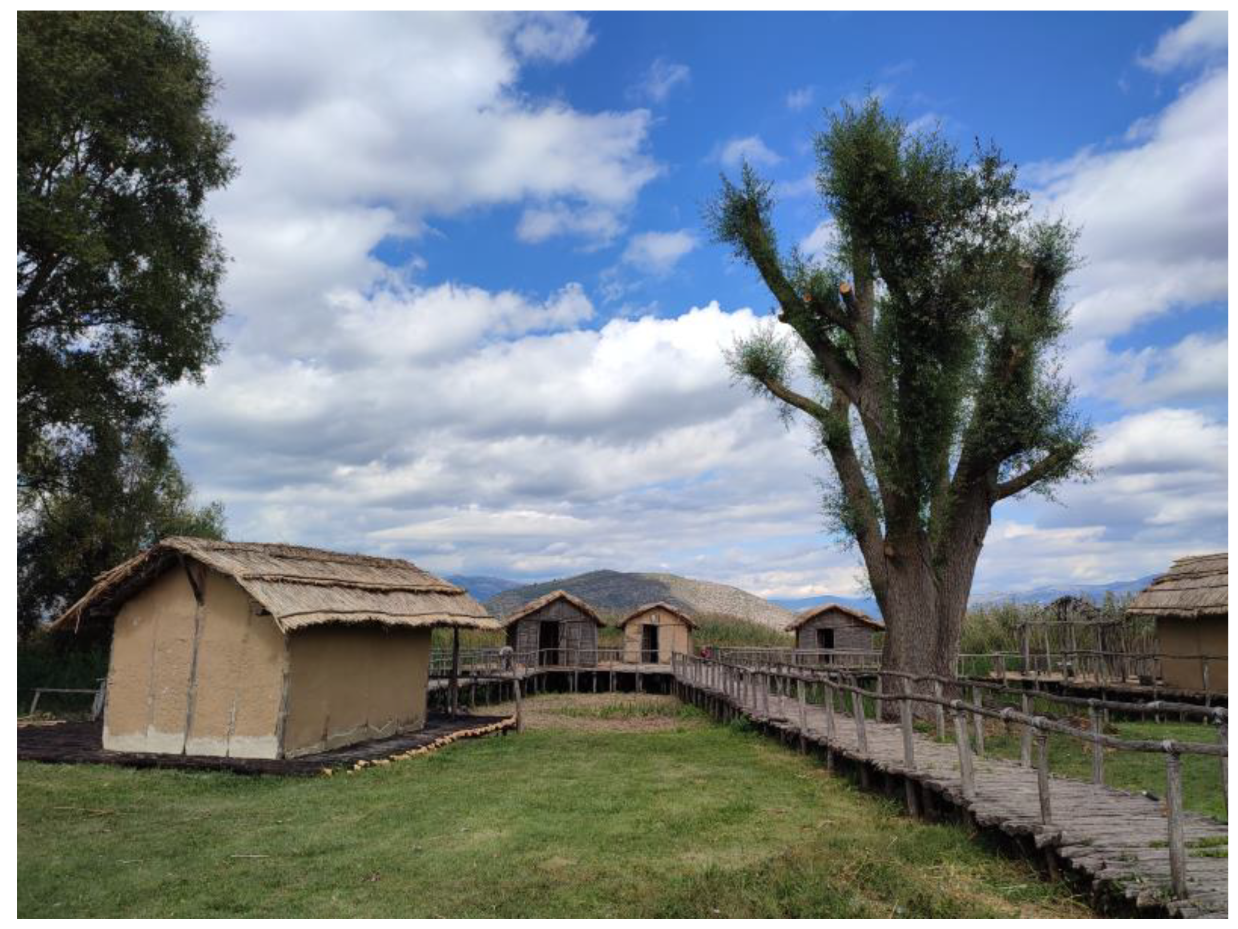
A representation of the settlement has been created near the site, which attracts tourists from Greece and abroad. The representation includes models of huts that are built on wooden stilt platforms, which are situated in the lake and close to the shore (
Figure 2). The huts are made of straw and clay. The huts also contain replicas of items found in the excavations, since the authentic items are kept in a nearby museum. Types of trees that were once part of the settlement’s natural environment were planted in the archaeological park and close to the model huts.
On 28 August 1938, an article in the local newspaper “Kastoria” reported information about the existence of a prehistoric lake settlement and the excavations led by a professor of archaeology named Antonios Keramopoulos. Professor Keramopoulos conducted archaeological research in the area from the year 1930, initially with the aim of locating the cradle of ancient Macedonians. Professor Keramopoulos returned to the area in 1940 and conducted excavations research in two different areas. One of them was in location “Nisi (island)” [
48]. The location was known since 1932 due to the wall that surrounded the area. The investigations of Keramopoulos were not continued because the professor’s scientific interest was mainly focused on dating the wall.
In 1966, hundreds of wooden stilts were revealed during a prolonged dry period that caused the lake level to drop significantly. A professor of architecture named Moutsopoulos photographed the stilts as part of his investigations in the area [
48].
A systematic excavation project began again years later, in 1992, under the supervision of Georgios Hourmouziadis, a professor of prehistoric archaeology at the Aristotle University of Thessaloniki. The excavations revealed the remains of an extensive lake settlement from the late Neolithic era. Thousands of objects were found in those excavations, including tools made of stone, bones, and flint. The findings indicate that the inhabitants engaged in agriculture, hunting, and fishing [
49].
Additionally, materials with which the huts were built, large storage jars made of clay, cooking utensils, woven baskets, ceramics, figurines, personal ornaments, flutes made from bone, and stone and bone jewelry were also discovered at the excavation site.
Moreover, an important finding of the excavations in the Dispilio lakeshore settlement is a wooden sign with engraved linear elements. The unique wooden plaque, which dates back to 5260 BC, gives the impression of an early form of writing, as similar symbols carved in clay have been found in other southern Balkan settlements. The clear symbols on the wooden sign could indicate some form of communication describing the activities of the Neolithic man. Currently, the wooden plaque is under a scientific conservation process, and an academic study of the object awaits [
49]. After the death of Professor Hourmouziadis, the Professor of Prehistoric Archeology at the Aristotle University of Thessaloniki, Konstantinos Kotsakis, became the director of the excavations. Professor Kotsakis and his team of archeologists completed in 2015 the project of the preservation of the prehistoric enclosure [
50]. Today Professor Kotsakis continues to be in charge of the excavations and has the scientific responsibility of the archeological park.
4. Materials and Methods
The study presents two location-based augmented reality applications for educating the public about the prehistoric lake settlement. In the beginning, certain pre-production considerations needed to be made. These included the authoring tools that would be used for creating the applications, the target audience, and considerations regarding the design of the applications. The related scientific literature and Internet resources were investigated to spot the appropriate tools that could meet the study’s aims, which were to create engaging applications and at the same time to provide ideas and guidance to educators who would like to create similar experiences and have little or no programming experience.
Two popular tools were found to satisfy the study’s aims, and their affordances were investigated thoroughly by examining the developer’s environment, the end user’s environment, and the related documentation. Third-party applications were also tested, and small prototype applications were developed to explore further the available features of the authoring tools. Taleblazer, a software platform developed by MIT, was used for developing the two applications. Both applications contain gamification elements, and one also attempts to harness the benefits of storytelling. It was also a design decision to configure the applications so that they can be experienced away from the archeological park, making them available to a broader audience. This option in location-based applications is often called couch mode [
47] or simulation mode.
Finally, a preliminary evaluation took place. Seventy-one (71) university students experienced the applications off-site and evaluated this experience using a questionnaire with Likert-scale items. In order to construct the evaluation questionnaire, the related literature was examined, and categories from known models that would apply to the specific applications were spotted and utilized. Furthermore, 58 school students experienced the applications on-site and evaluated the experience using the same questionnaire. In this way, the applications were experienced and evaluated by different target groups, both off-site (couch mode) and on-site.
5. Creating Educational Location-Based Mixed Reality Applications for the Prehistoric Lake Settlement of Dispilio in Kastoria
The first consideration to be made was the target audience of the applications. It was decided that the main target audience would be primary and secondary education students, as it is expected that in the near future a large number of schools will be visiting the recently renovated archaeological park as a part of an educational program organized by the Environmental Education Center of Kastoria.
The applications are a joint effort between the Department of Digital Media and Communication, University of Western Macedonia, and the Environmental Education Center of Kastoria. A significant part of the application content was produced for the purposes of a student thesis. The DMSClab (Digital Media and Strategic Communication Lab) of the Digital Media and Communication Department, Western Macedonia, collaborates with the Environmental Education Center of Kastoria to implement research and education projects related to new technologies in education.
The student working on the specific thesis also collaborated with the research team of archaeologists from Aristotle University, Thessaloniki, Greece, and the leading professor supervising the ongoing excavations at the settlement and is scientifically responsible for the archaeological site. The student asked for the team’s help in order to eliminate errors in the game scenarios regarding scientific facts.
Besides school students, the applications would also be available to all visitors of the archeological site, and a relevant QR code will be available at the site entrance for downloading and installing the application.
As the primary target audience will be school students visiting the park, the applications would have to be appealing and engaging for this audience. As already mentioned, the project also aims to inspire educators who would like to produce similar applications and to provide them with ideas and guidance.
Having these goals in mind, the next consideration to be made was the authoring tools that would be used for implementing the applications. The technology adopted and the capabilities of the chosen solution would also determine to a large extent the options that the creator would have for designing the application scenario.
5.1. Deciding on Which Tool to Use
Various tools can be used for creating location-based AR applications. Some of the tools provide the developer with an extensive range of capabilities, but at the same time, they need advanced programming expertise in order to create even simple applications. The Google Maps API, combined with technologies such as ARCore and ARKit or the Unity cross-platform game engine, in combination with the Map Box Maps SDK, are listed among these solutions. As already mentioned, the vast majority of the cultural heritage AR applications that are found in the literature are created using such tools [
9]. On the other hand, there are also technological solutions requiring little or no programming knowledge. The study will concentrate on such solutions in order to meet one of the study’s aims, which is to provide ideas and guidance to educators who want to create location-based AR applications for learning.
The following authoring tools were spotted by exploring the related literature and various Internet resources: (a) ARIS, (b) Taleblazer, and (c) Metaverse studio. ARIS is an open-source augmented reality interactive storytelling engine created by Fieldday, a research laboratory at the Wisconsin Center for Education Research (
https://fielddaylab.org, accessed on 4 October 2022), Taleblazer (
http://taleblazer.org/, accessed on 4 October 2022) is an open-source platform developed by MIT (Massachusetts Institute of Technology), and Metaverse Studio (
https://studio.gometa.io/discover/me, accessed on 4 October 2022) is a platform created by GoMeta an American software company headquartered in San Diego.
All of the above software solutions share many similarities. Educators can use these tools to create AR games (e.g., scavenger hunts), informative tours, and storytelling experiences.
All the tools have a web-based authoring environment and produce applications that users can execute on their mobile devices. Applications are created by putting GPS locations on a digital map and associating multimedia elements with these locations.
The basic features of the authoring environment of these tools are the following:
- (a)
ARIS has a drag-and-drop authoring environment with three basic objects: plaques, items, and characters. Plaques are points of text or multimedia information associated with geolocations. Items are digital objects that users can pick up and trade between them. Characters are virtual people that players interact with.
- (b)
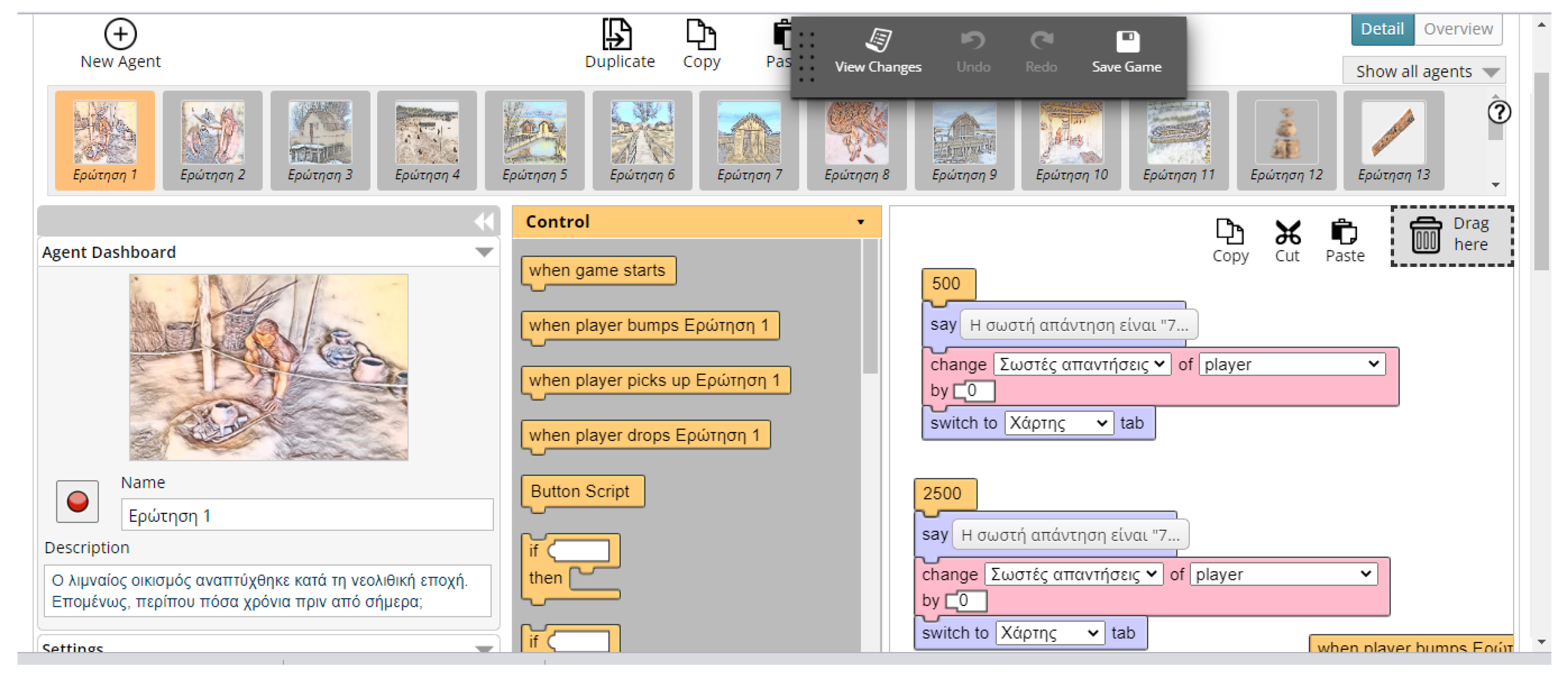
Taleblazer has a visual block-based programming environment similar to Scratch, another popular product of MIT (
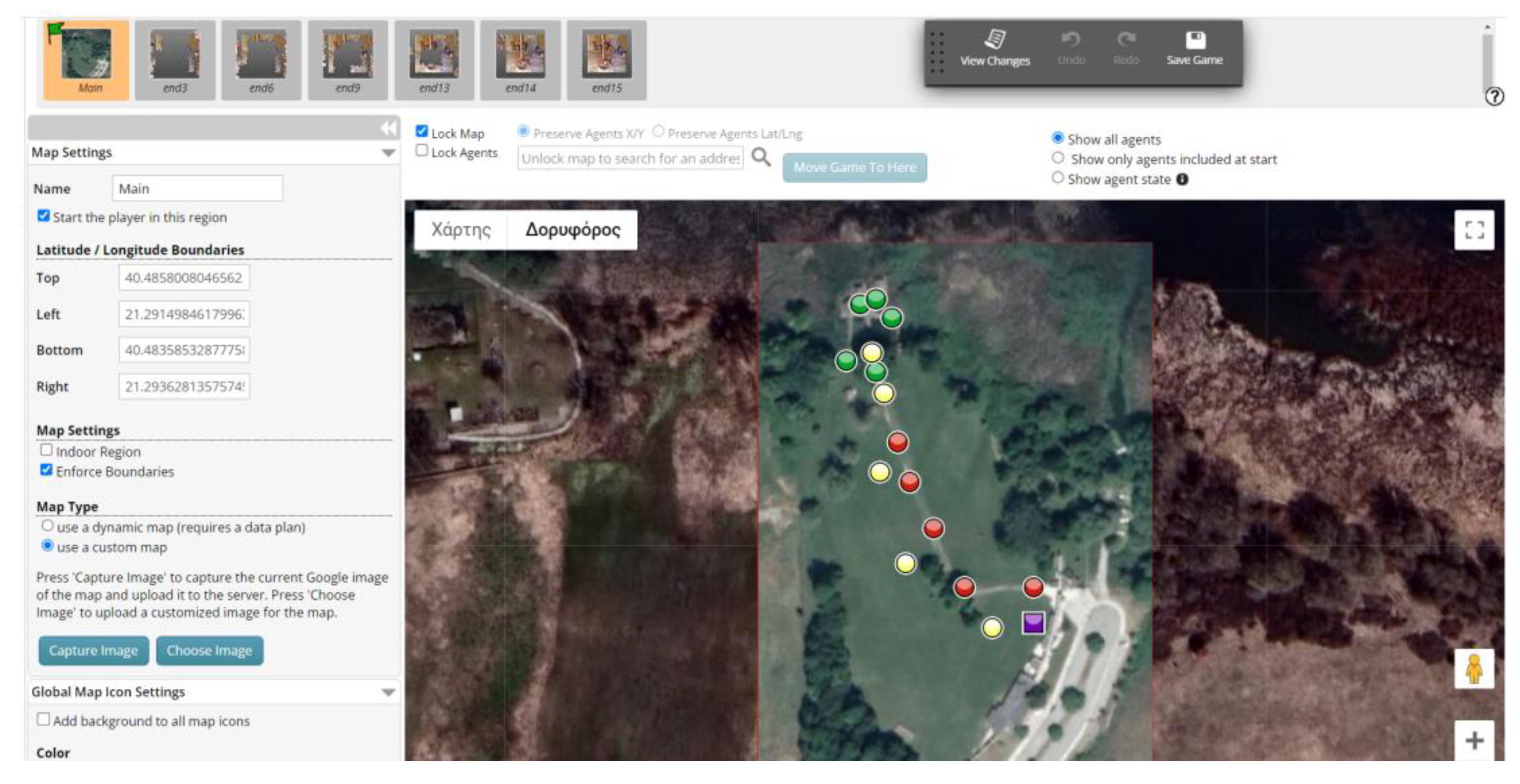
Figure 3). The basic elements of this environment are “Regions” and “Agents”. Regions are the physical areas on a map where the game takes place. The first thing that a designer must do is to determine the region of the game on a digital map with the use of a selection tool. After the region is set, “Agents” can be introduced. Agents are digital content associated with a GPS location and activated when a learner “bumps” into this location (
Figure 4).
- (c)
Experiences in the Metaverse AR environment are created in the Experience Storyboard. The Experience Storyboard is a drag-and-drop canvas where the designer combines elements called scenes and blocks. Scenes are the visual elements of the experience, and blocks are logic elements that perform actions while an experience is running. The user defines the flow of the experience by creating lines (links) between the elements.
As mentioned, to decide which tool to adopt, the affordances of these three tools were investigated. ARIS was excluded as a choice early in this investigation, since ARIS applications can only run on IOS devices. This is a considerable drawback, since many users own mobile devices that operate on Android (e.g., smartphones).
In order to compare the features of Taleblazer and Metaverse studio, the developer’s environment and the end user’s interface were examined thoroughly, the documentation of each tool was studied, third party applications created with these tools were tested, and small prototype applications were developed.
Finally, Taleblazer was found to satisfy better the goal of creating a location-based AR applications for cultural heritage education for the following reasons:
- (a)
Taleblazer applications can run on both IOS and Android mobile devices. While Metaverse studio can also accomplish this, ARIS applications can only run on IOS devices.
- (b)
Taleblazer can also use custom maps besides Google’s dynamic map. This means that developers can create their own maps, and games can be played on these custom maps as long as they are matched appropriately with the physical locations. Using custom maps, details of the physical environment that cannot be depicted in Google Maps (e.g., narrow paths in cities, archeological sites, or paths in nature) and imaginary content can be included (e.g., images used for storytelling). Furthermore, an Internet connection is not needed when using custom maps, avoiding data consumption in this way. Metaverse studio does not support such an option, and an Internet connection is always required to execute an application made with this tool. Furthermore, custom maps are useful in places where GPS tracking is unavailable, such as museums’ interior spaces. For these cases, Taleblazer documentation provides instructions on how to build games for interior spaces using custom maps. Although the prehistoric lake settlement in Dispilio is located in an outdoor area, where cellular data are available, it was decided to use custom maps to avoid data consumption and also to be able to add additional layers of information to the map (e.g., icons).
- (c)
Taleblazer can support role-playing games. One can easily create different roles, and different scenarios can be built around these roles. This feature can be helpful in designing storytelling experiences.
- (d)
The Taleblazer environment allows the manipulation of the “bump” or “tap to bump” settings. Users are said to “bump” into a GPS location when they get in a certain proximity from the location. Content is activated automatically or by tapping on the GPS location icons on the map. The proximity that the user must be in order for the digital content to be activated can be configured in the Taleblazer programming environment. In Metaverse studio, on the other hand, the proximity in which the user will have to be in order for the digital content to be activated is always fixed to a 30 m radius. This option that Taleblazer provides can become helpful for cultural heritage applications. For example, the creator may want the player to get very close to a physical location to observe something small, such as a street sign or a sign on a door or a wall. This is also the case for archeological sites such as the prehistoric settlement in Dispilio, where the user is prompted to observe some things from a short distance (replica items, trees, etc.)
- (e)
Taleblazer games can be played without visiting the physical location (couch mode or simulation mode). A specific setting in the programming environment enables or disables this option. This option can be enabled when testing the applications but also in cases where we want to distribute the application to people who cannot visit the location where the game unfolds. Metaverse studio does not support this option, and this is a considerable disadvantage.
As far as multimedia content is concerned, Taleblazer has fewer options when compared to Metaverse studio. Taleblazer applications can incorporate text, sound, and videos. On the other hand, Metaverse studio applications can support a broad range of multimedia elements, such as graphics, 3d models, sound, video, 360° video and images, webpages, and the ability to store photos and videos captured by end users. Another option available in the Metaverse studio platform is the ability to view objects in AR view. That means 2D images and 3D models can appear in the natural environment through the mobile device’s camera lens.
Concluding, we can say that the advantages of Taleblazer for creating location-based AR applications outweigh the advantages provided by Metaverse studio. ARIS was ruled out early in the investigation, since it cannot produce applications that run on Android devices.
5.2. Design Considerations
An insight that was drawn from existing literature was that on tours, games, and storytelling AR experiences that aim to educate the public about a museum, an archeological site, or other places of cultural heritage interest, a goal should be to avoid the players’ attention to be shifted from the immediate surroundings solely to the digital world. For locative cultural heritage games, mechanics such as those adopted in Pokemon GO and Ingress are generally unsuited because they sacrifice presence in the physical space for immersion into the game world. For cultural heritage games, it is more appropriate to develop visual and audio elements that link the game world with the physical space, rather than ones that only focus on a digital game [
51].
It is also known from the literature that gamification and storytelling are two efficient methods for increasing learners’ motivation, engagement, and satisfaction, especially for younger audiences. These methods are also known from research to aid in achieving better learning outcomes. Thus, it was decided to use both methods. The gamification elements included in the applications were the collection of points and items, prizes, and questions and answers that frequently appear during the tours. Through the questions, visitors are prompted to observe their immediate surroundings and keep their focus on the information provided at various stages of the game, since they would need to recall this information to answer questions correctly.
Taleblazer gives the option to make the game available to users who are present at the game’s location, but also to users who cannot visit the game location for various reasons (people living in other regions, people with disabilities, etc.). We decided to also make the applications available to users who cannot visit the archeological site. In this case, the users will have a typical mobile educational gaming experience rather than a location-based experience.
At this point, it has to be said that the design of the applications was discussed amongst IT experts and educators with many years of experience. Early prototypes of the applications were also tested by this team of experts and educators on-site and also by a small group of university students. Suggestions for making the experience better and for resolving certain ambiguities were put forward during this process, and necessary modifications were made to the applications.
5.3. Description of the Location-Based Augmented Reality Applications
In order to provide knowledge about the prehistoric settlement, two applications were created: an informative application and a storytelling experience. Both applications also contain gamification elements. The applications aim to inform the visitor about the way of life in the prehistoric settlement and the artifacts used in daily activities. The website of the applications is
https://kpe-kastor.kas.sch.gr/taleblazer/?page_id=407 (accessed on 22 October 2022). The applications are currently in Greek and English versions will be available in the future.
5.3.1. Informative Application “Once upon a Time in Dispilio”
The informative digital tour that contains gamification elements is called “Once upon a time in Dispilio”. During this tour, users must reach specific locations in the archaeological site and activate digital content. The digital content is in the form of text, images, and sound. Questions and answers are used at almost every GPS location. The players are presented with multiple-choice questions, and historical information is given to them as feedback. Representative graphics accompany the questions, and the game contains narration and sound effects.
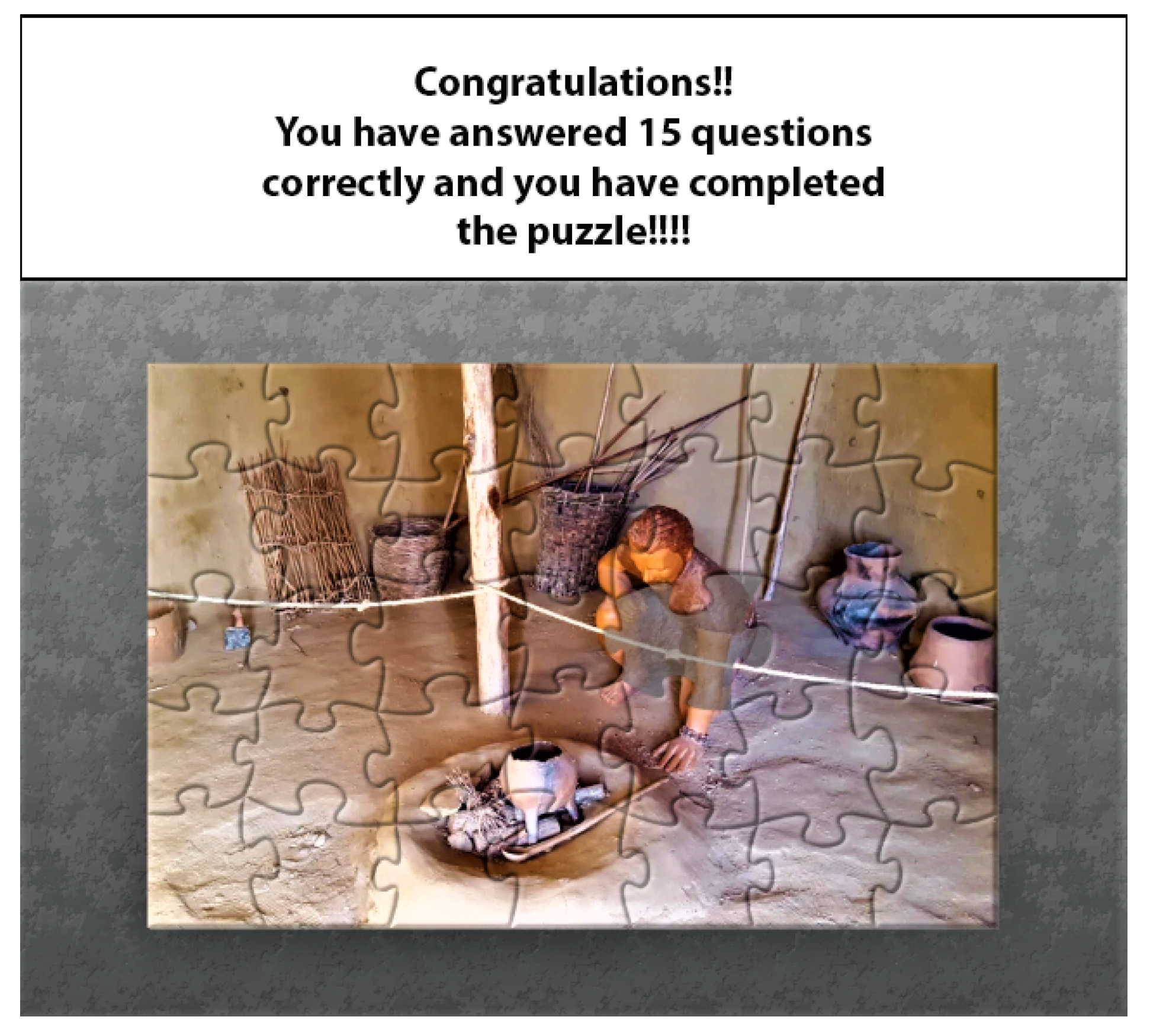
Players gather points every time they answer a question correctly, and at the same time, they take a step to complete an image puzzle by winning a puzzle piece that is placed in the correct spot.
The aim of the educational tour in the archaeological site where the model huts are is to provide knowledge about the following aspects: the era when the settlement was developed and how this period is estimated by examining the age of the wooden platform stilts (dendrochronology); the leading archaeologists that were involved in the excavations and their contributions; the trees that surrounded the settlement at the Neolithic period; possible reasons of why the settlement huts were built on stilt platforms inside the lake and very close to the shore; the materials used for building the huts; the types of trees used for making the wooden stilts; the main activities of the humans that lived in the settlement (fishing, hunting, agriculture, and stock raising); the various artifacts found in the excavations, such as small figurines (the lady of the lake, the wise old man, the standing bear, etc.), flutes, and tools used in daily activities such as hunting and fishing; the materials used for making these artifacts and tools; and the importance of the findings.
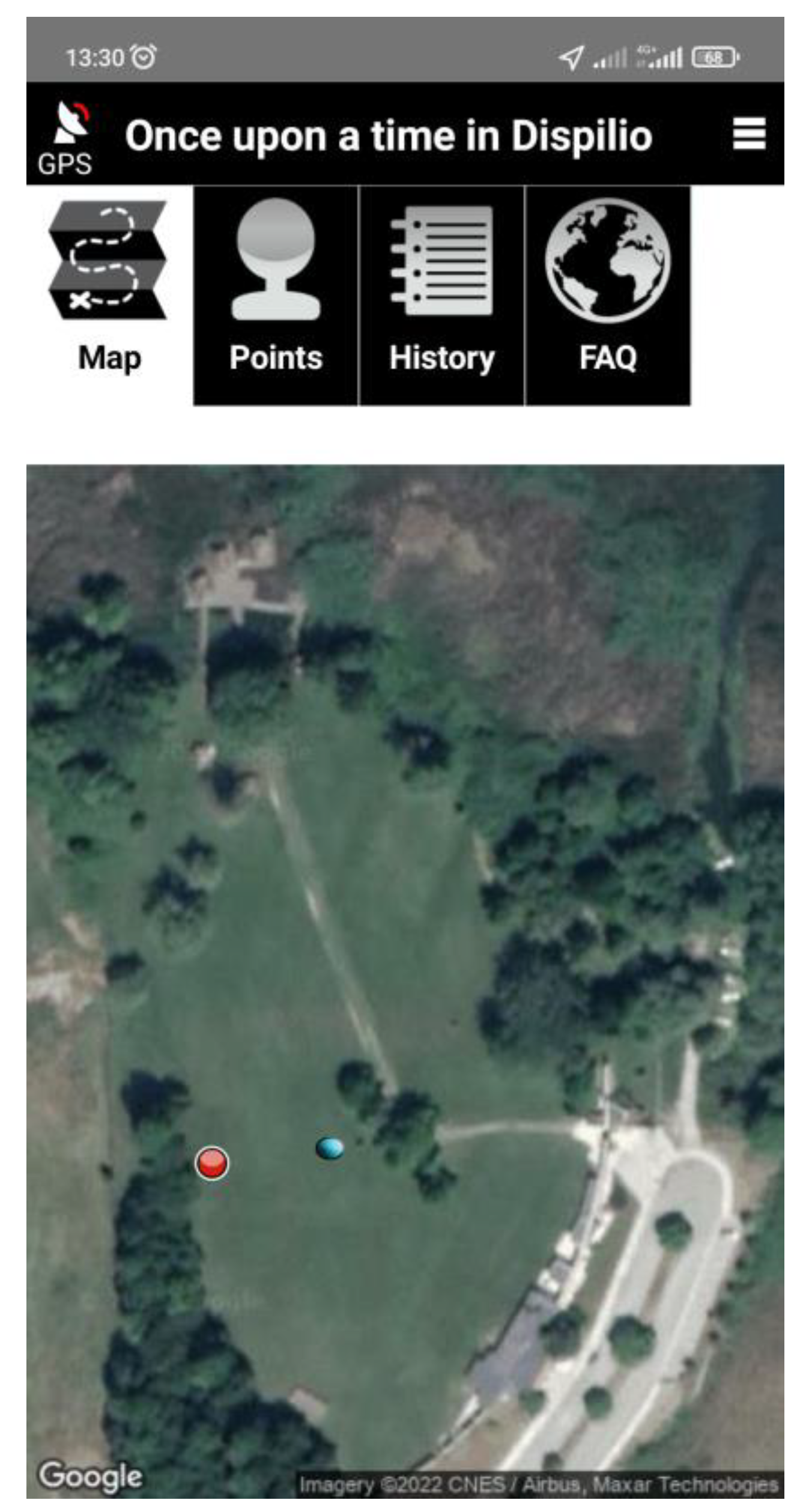
The game consists of 15 multiple-choice questions. After choosing the appropriate answer, the players are informed whether they are right or wrong, and further information is given as feedback. In
Figure 5, the initial screen of the game is presented, and in
Figure 6, one can see the map used for navigating the user in the prehistoric representation park. The blue dot is the position of the player. Red dots represent the next target location to be reached by the players.
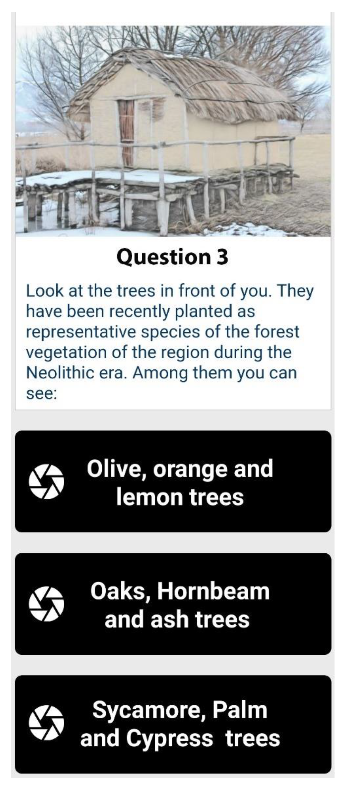
The textual information depicted in the application images throughout this manuscript was translated into English for publication purposes. The applications are currently in Greek, but an English version will soon be available to cover the needs of foreign tourists visiting the site. The questions can be answered mainly by observing the physical world. For example, questions regarding the human activities that covered food needs, the materials used for building the platforms and the huts, and the materials used for creating tools and other artifacts, can all be answered by examining the immediate surroundings. For example, in
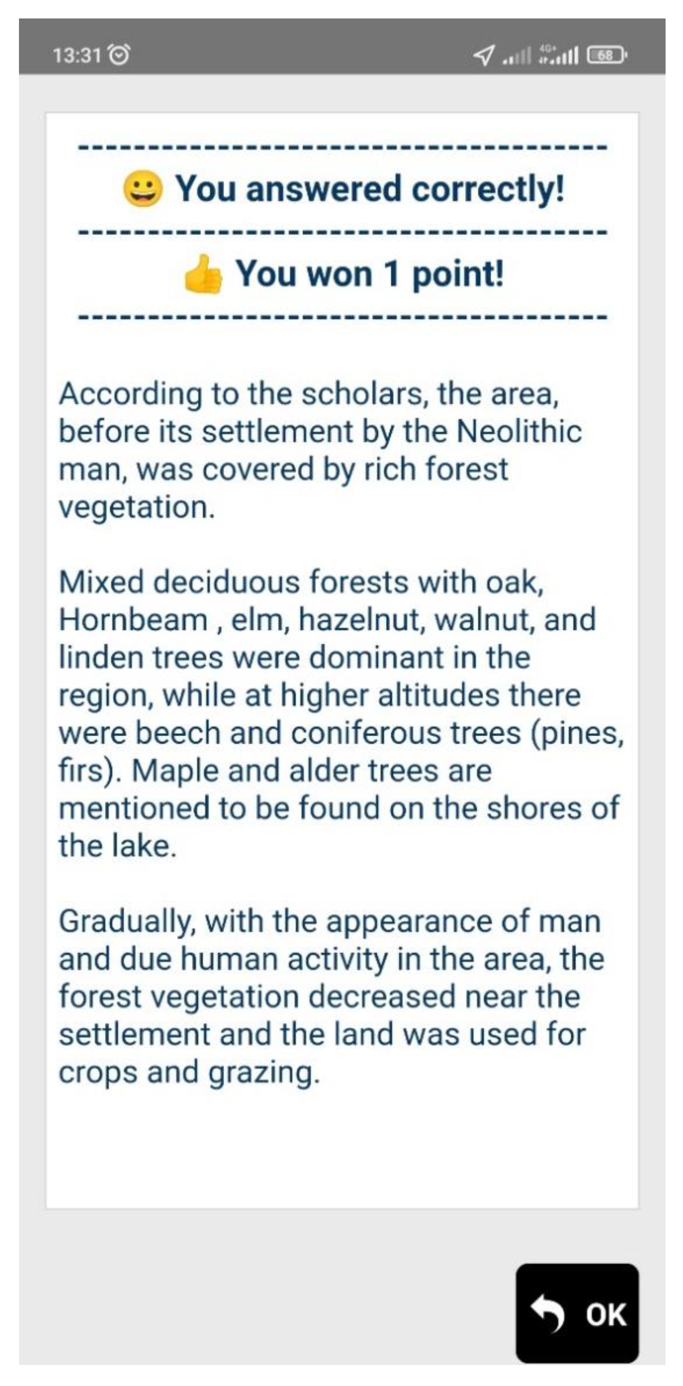
Figure 7, the players are prompted to answer a question regarding the types of trees that existed around the settlement in the Neolithic era. As already mentioned, tree types like those that existed in the settlement during the Neolithic era were planted near the model huts. The players are prompted to observe the trees and identify them. Players could also utilize mobile applications for flora identification to complete this task.
Figure 8 depicts the feedback delivered to the user.
Similarly, the materials used for building the huts and the stilt platforms, and the tools and other items used in the daily life of the inhabitants, can be identified by observing the model constructions (which were built using the same materials) and the items replicas that are placed within the huts.
The image of the puzzle depicts the interior from one of the huts. If all 15 questions are answered correctly, the puzzle is completed (
Figure 9).
It becomes evident from the description of the application that the design goals are met. The application contains gamification components and keeps the focus of the users on the archeological site by posing questions that require observation of their surroundings.
5.3.2. Storytelling Game—“Crime in the Lake Settlement”
The second application, “Crime in the lake settlement”, aims to educate the visitors about the prehistoric settlement regarding aspects similar to the first application, but this time by utilizing the power of storytelling.
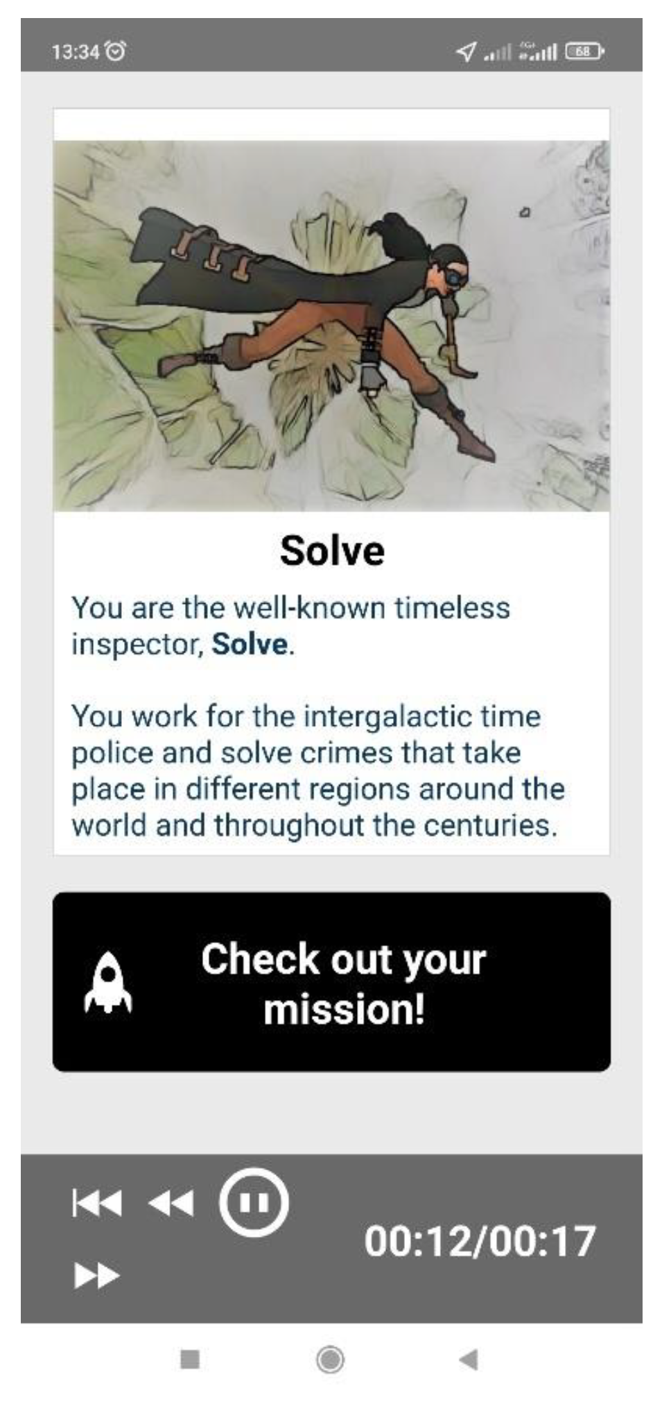
In this application, the user takes on the role of an intergalactic inspector who works for the intergalactic police called Inspector Solve. In
Figure 10, we can see the initial screen of the game. The inspector travels through the universe and through time to solve various crime mysteries. His latest mission is to solve a crime mystery that has taken place in the prehistoric lake settlement of Dispilio.
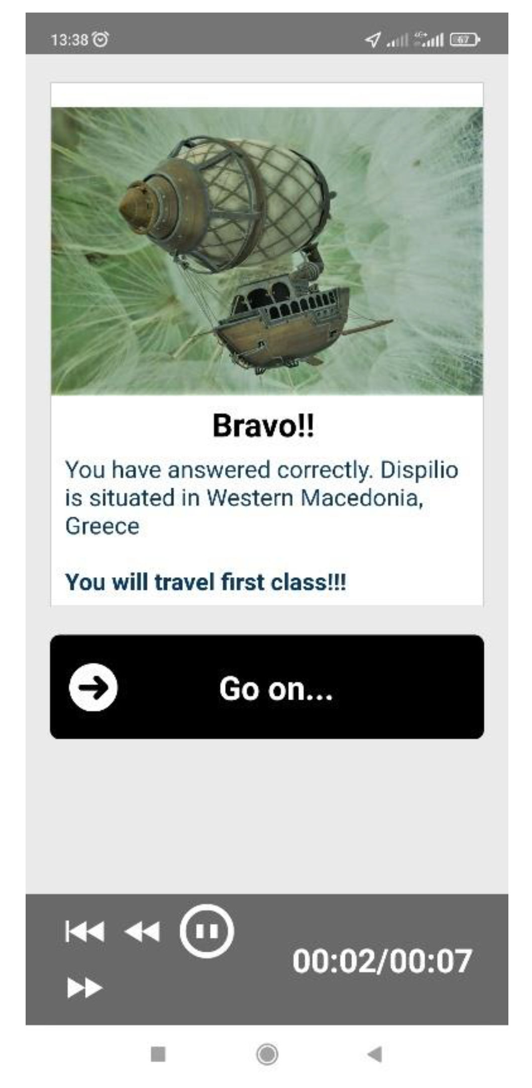
Throughout the storytelling game, the inspector is posed with questions and gathers prices that will make his tour more pleasant if he answers correctly (hat for the sun, food, drinks, fast vehicle for transportation, etc.). Prices are stored in the Taleblazer inventory. The users also receive humorous feedback if they fail to answer correctly. For example, suppose they respond correctly to the game’s first question regarding the settlement’s geographical area. In that case, they get to travel in the first-class compartment of the inter-space-time air balloon to get to the landing site (
Figure 11). Otherwise, they will travel in the luggage compartment.
The multimedia elements of the game are images that have gone through image processing, digital sound effects, and digital narration. The student who wrote the story script as part of her thesis in the Department of Communication and Digital Media performed the narration for both applications. The student holds an academic degree in theatrical studies and has substantial experience in script writing, directing, and acting.
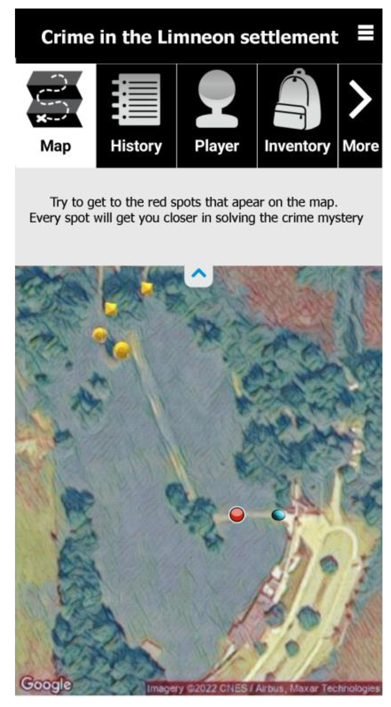
After a short introduction, in which the inspector and his mission are presented, the users will have to start moving into the archaeological site to reach the red dots on the application map. The player’s position is again indicated with a blue dot. (
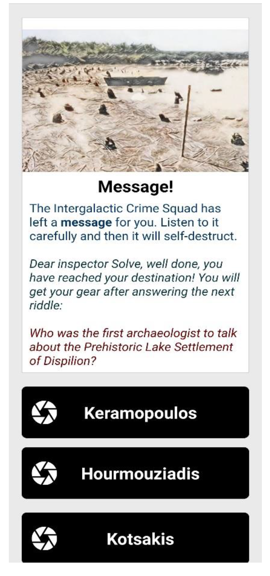
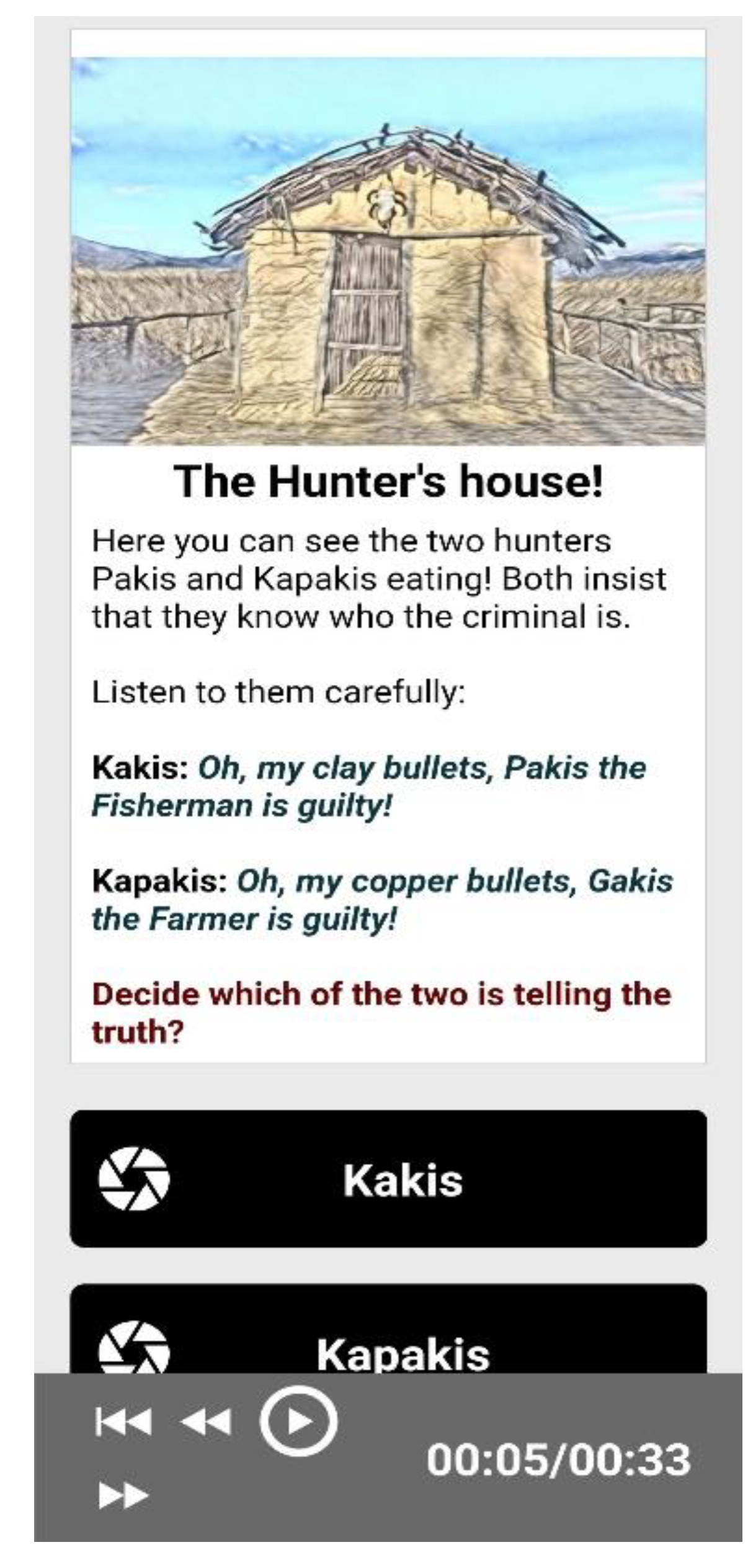
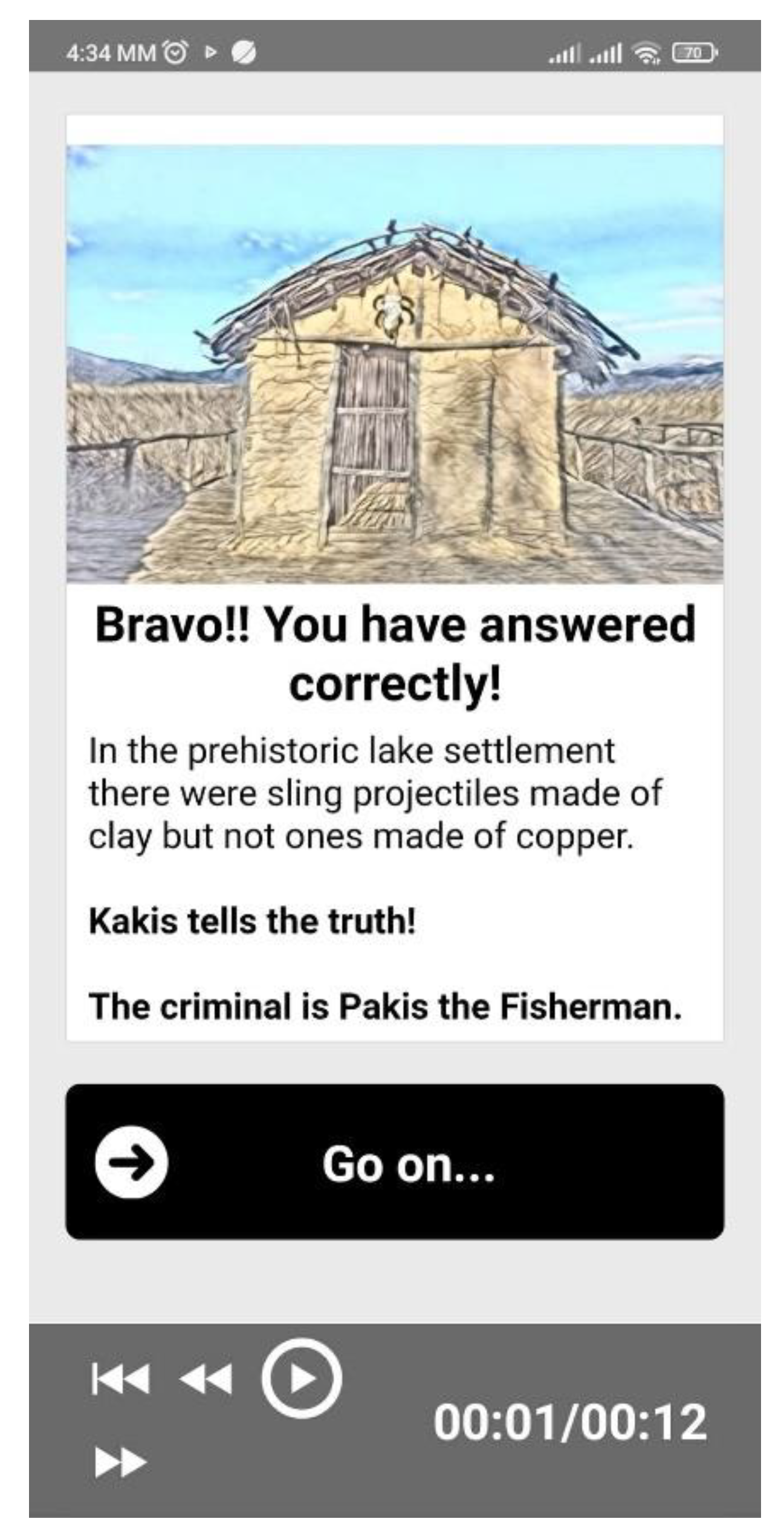
Figure 12). The players receive information and are prompted to answer questions to progress in the game (e.g.,
Figure 13 and
Figure 14). They also receive feedback with more detailed information (e.g.,
Figure 15).
The inspector meets different characters at various locations in the settlement (e.g., by the hunter’s hut). The characters give the inspector clues regarding the victim and the criminal. The characters are mainly represented by processed digital images. These are images from various figurines found in the excavations (the wise old man, the lady of the lake, etc.) and various effigies that can be found in the huts (
Figure 16). The effigies represent Neolithic inhabitants who carry out daily activities and are surrounded by replicas of tools and utensils that were used in the Neolithic age. The player tries to solve the mystery by progressing in the game but at the same time receives information regarding the settlement and the way of life of its inhabitants.
6. Evaluation
As mentioned in the previous section, the target audience of both applications is mainly secondary-school students. In the near future, it is expected that the applications will be experienced and evaluated by many students attending an environmental program organized by the Environmental Education Center of Kastoria, Greece.
The visits concern school classes that apply to the Environmental Education Center in order to follow one of its educational programs. On arrival at the settlement, the students are split into groups and either play the game on their own or are accompanied by an educator from the center who acts as a facilitator and discusses their choices. The center provides tablets, but the students can also use their smartphones. Currently a small number of school classes have visited the settlement and experienced the application.
In order to conduct a preliminary evaluation of the AR applications, a sample of 71 university students and one of 58 school students were used. The university students employed for the evaluation were attending relevant courses: Digital Media and Education, and Digital Storytelling.
The university students experienced the applications off-site and during class time. As already mentioned, it was a design decision to allow the applications also to be executed away from the archeological site (couch mode) so that a broader audience could experience them. Therefore, the university students experienced the gamified applications away from the settlement and evaluated this specific experience. Students were asked to download the applications on their mobile devices before coming to class (with a relevant announcement in the university LMS). All the students were familiar with AR location-based applications, since MR technologies are covered in the curriculum even from the first year of their studies, and thus the students were aware of what it would be like to play the games on-site. The educator who supervised this process also described how the applications would work if played on-site.
Furthermore, the same questionnaire was also distributed to 58 students from 3 school classes (primary and secondary schools) that visited the Dispilio settlement and experienced the two applications on-site. The students were also told to download the applications on their mobile phones before coming to the archeological site, but tablets with the applications installed were available.
Therefore, in this study, the applications were experienced both on-site and off-site (couch mode).
The questionnaires used for the evaluation were identical for both applications and consisted of 22 Likert-scale questions belonging to 7 main categories (see
Appendix A). The categories were the following:
Challenge: the feeling a player gets when he/she proceeds in the game (proud, satisfied, excited, etc.).
Outdoor activity: being motivated by the application to engage in an outdoor activity.
Ease of use.
Educational usefulness: improving users’ knowledge about the settlement.
Interaction and collaboration amongst co-players.
Intention to reuse the same application or to experience similar applications for other places of cultural heritage interest .
Satisfaction/enjoyment.
The questions belonging to the above categories were mainly derived from the existing literature. More specifically, questions measuring “challenge” were derived from [
52], questions measuring “outdoor activity” were derived from [
53], questions measuring perceived usefulness and intention to reuse where derived from [
54], questions regarding satisfaction and enjoyment were derived from [
54,
55], and questions measuring interaction amongst players and collaboration were constructed for the purposes of this study.
The questionnaire also contained one open-ended question where the students were asked to express freely their opinions about what they liked or disliked about the two applications. The second questionnaire also included two more questions. The first question asked the students which game they liked more and why, and the second asked which game was better in terms of knowledge gain.
7. Evaluation Results
7.1. Evaluation Results from the 71 University Students
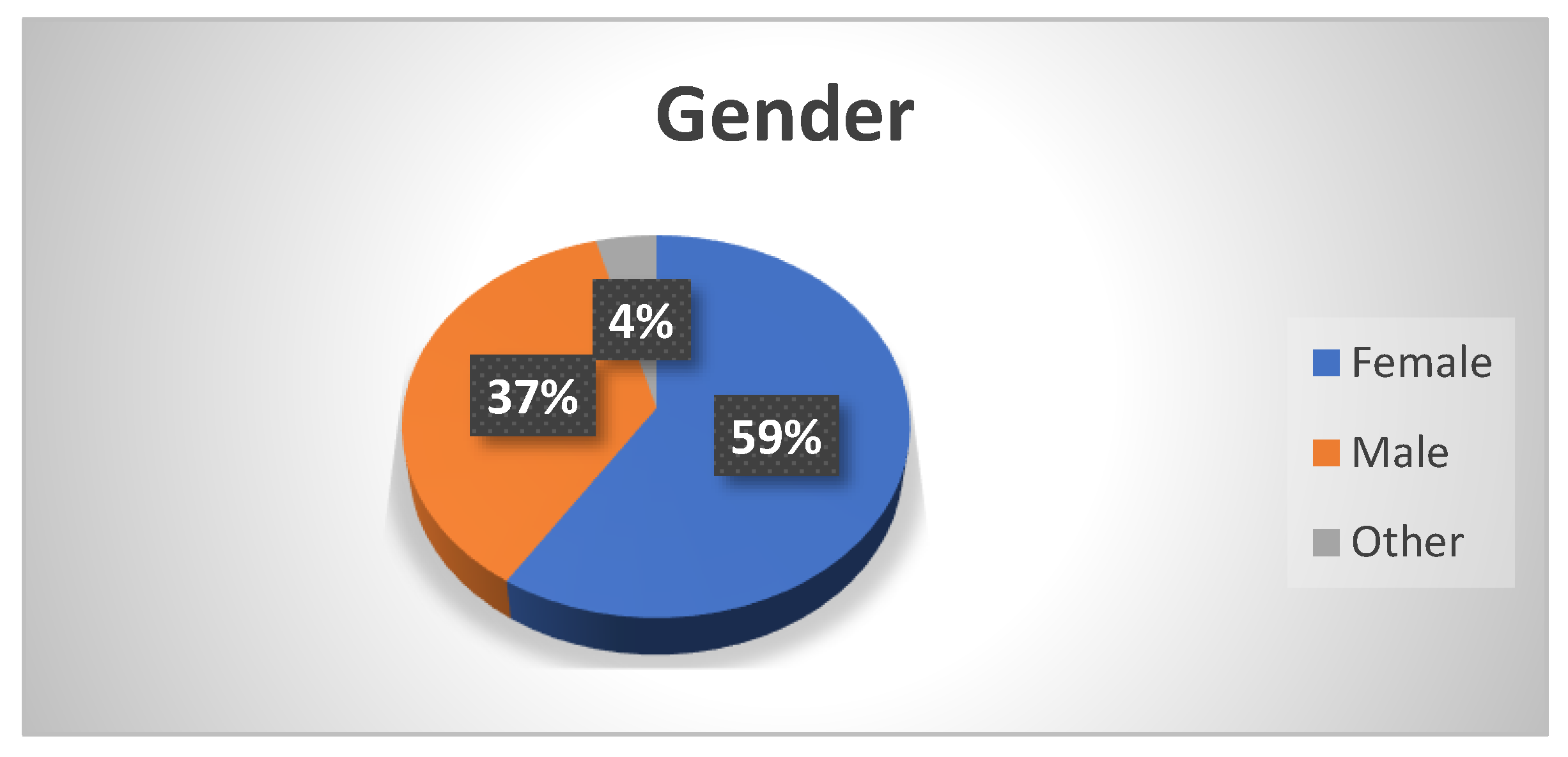
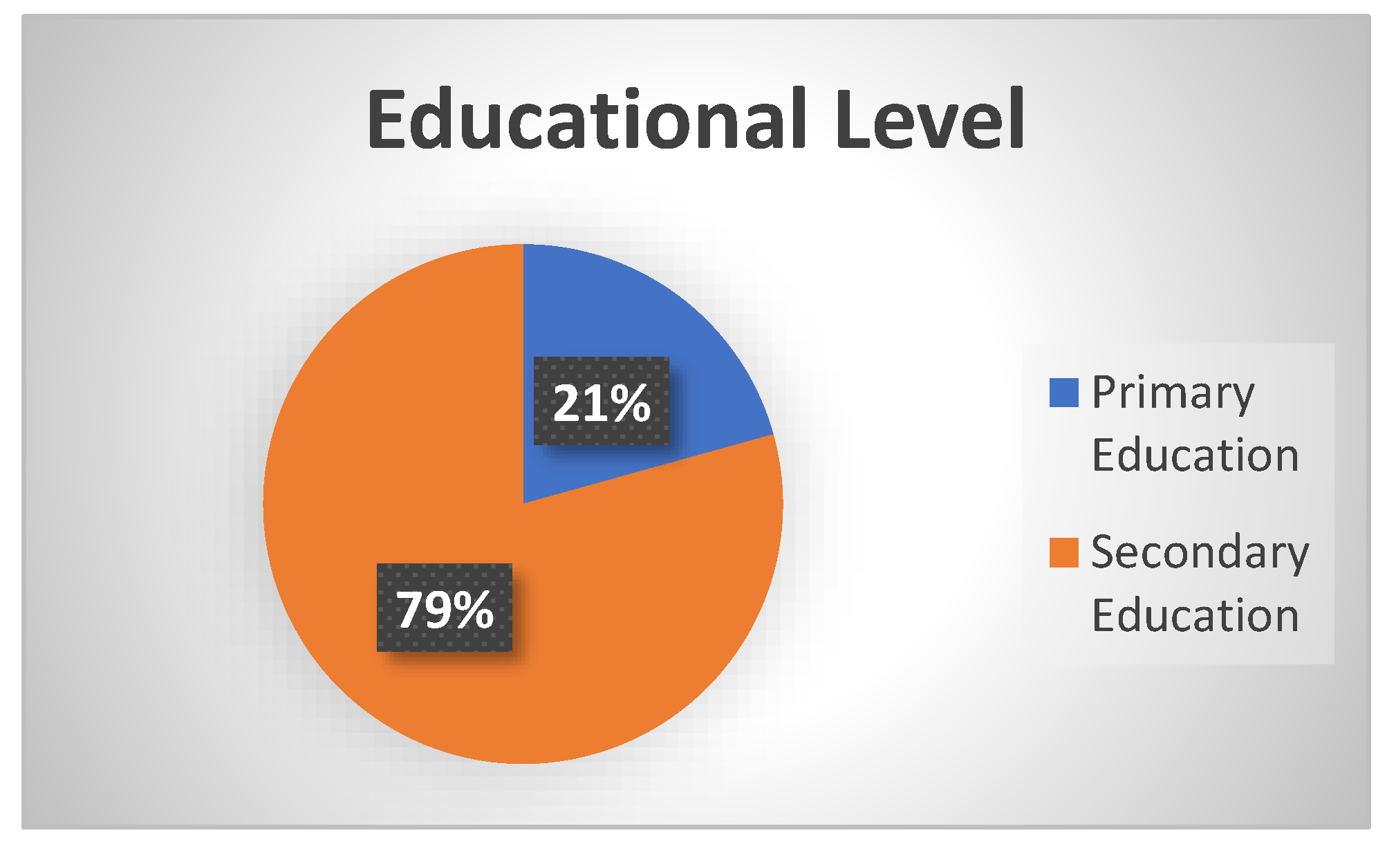
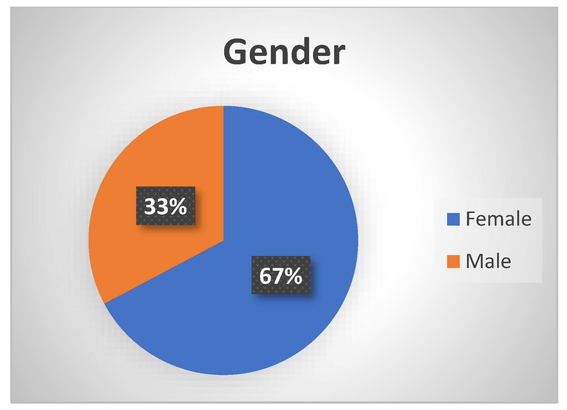
Some demographic characteristics of the sample of the 71 university students can be seen in
Figure 17 and
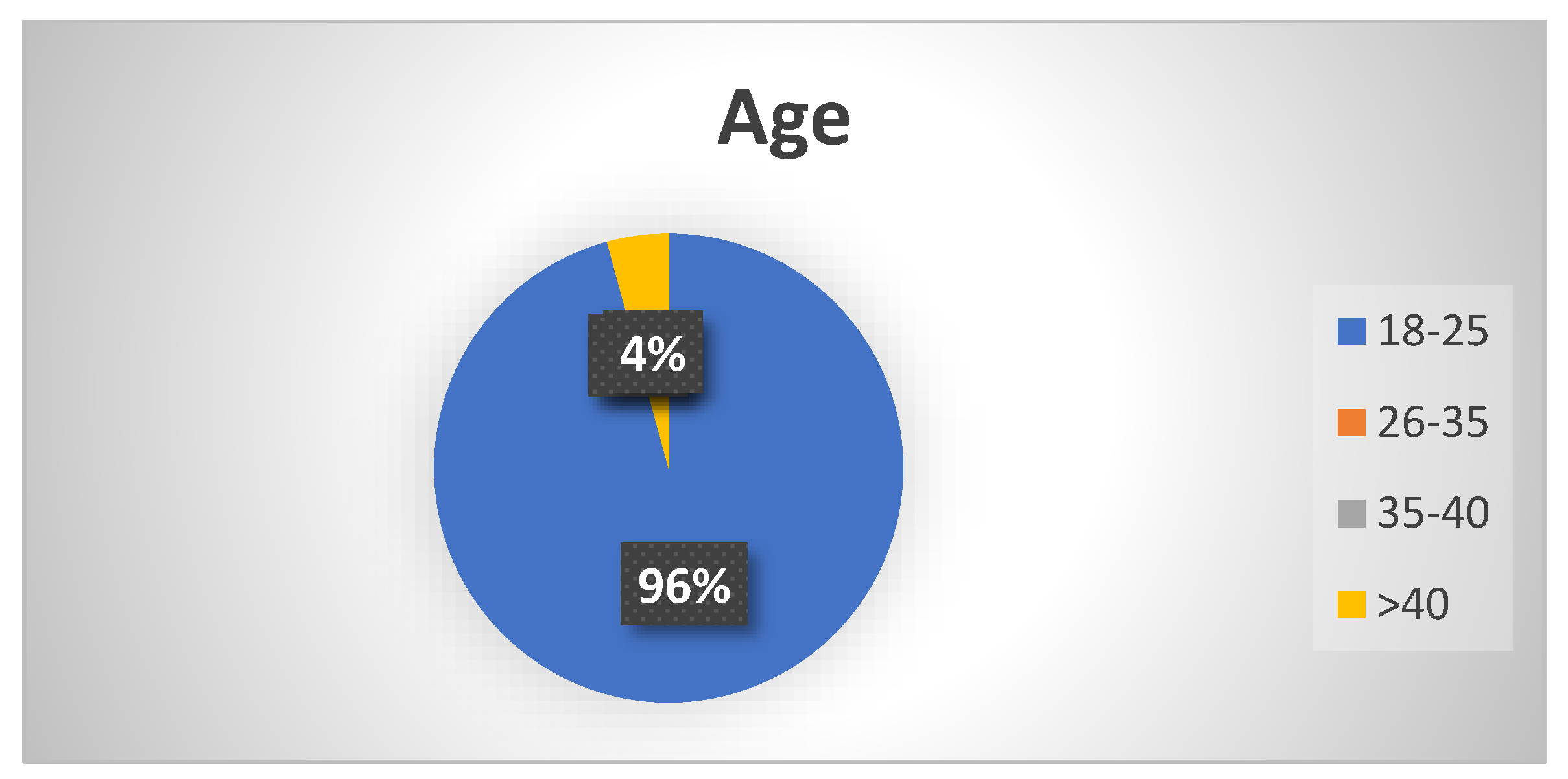
Figure 18.
Regarding the age, most of the students were in the range 20 to 21, and there were also three mature students above 40.
Seven summative scales (average scores of items) were created to examine the two scenarios in regard to the level of perceived personal challenge, outdoor activity, educational usefulness, ease of use, social interaction and collaboration, satisfaction/enjoyment, and intention to play the game again or similar games on a different topic.
The seven summative scales were obtained using the SPSS statistical package by adding the scores of the items that comprised each construct and dividing the total by the number of items.
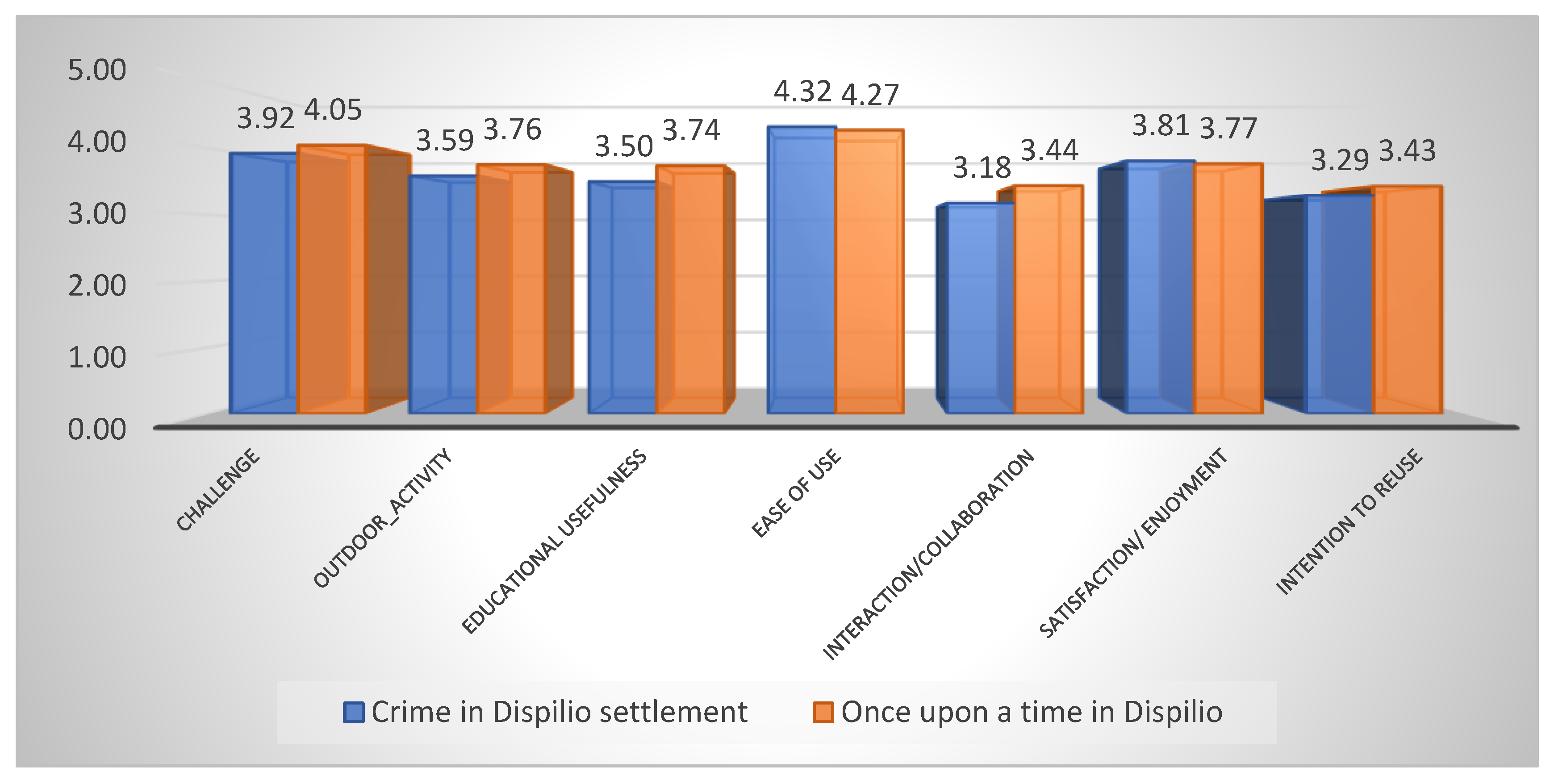
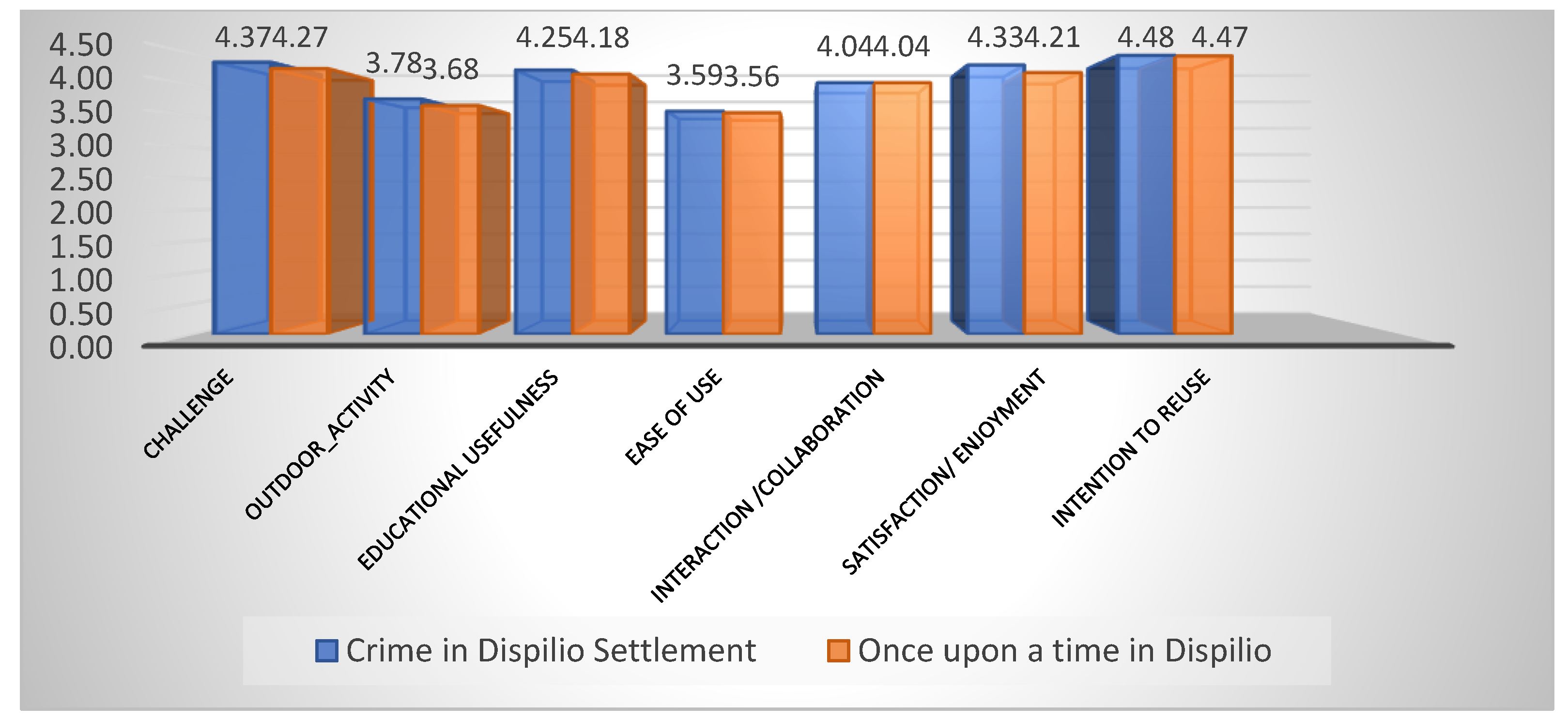
All scales exhibited satisfactory internal reliability, as the Cronbach’s alpha values exceeded the 0.70 cut-off. The average scores can be seen in
Figure 19.
Both applications scored above average in all categories; the best results were for the category “ease of use”. This can be attributed to the affordances of the authoring tool used for creating both applications, Taleblazer. Both applications also scored high in the category “challenge”, meaning that players felt excited, proud, and satisfied when they were able to answer questions correctly and gather points and prizes. The differences in the average scores for every category between the two applications were not significant. Although the students were given the option to collaborate with their peers while playing, the category “interaction and collaboration with peers” scored lower when compared to the other categories. Intention to reuse also scored lower also. It has to be mentioned that this category consisted of two questions that concerned the intention to use the same application again and one that concerned the intention to use similar applications covering other topics. Many students felt that one time for the same application was enough. However, when they were asked if they would like to experience a similar game but for a different archeological site or different concept altogether (e.g., environmental or cultural) their response was highly positive. As can be seen in the graph, the students were generally satisfied with the applications, and they found them entertaining.
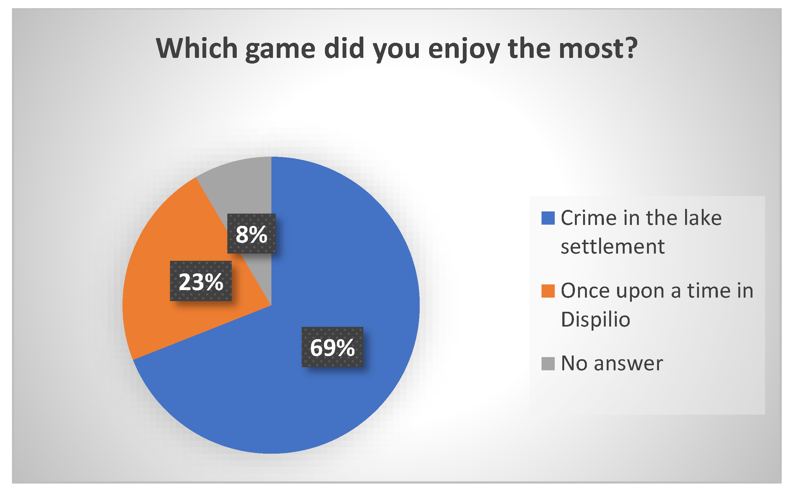
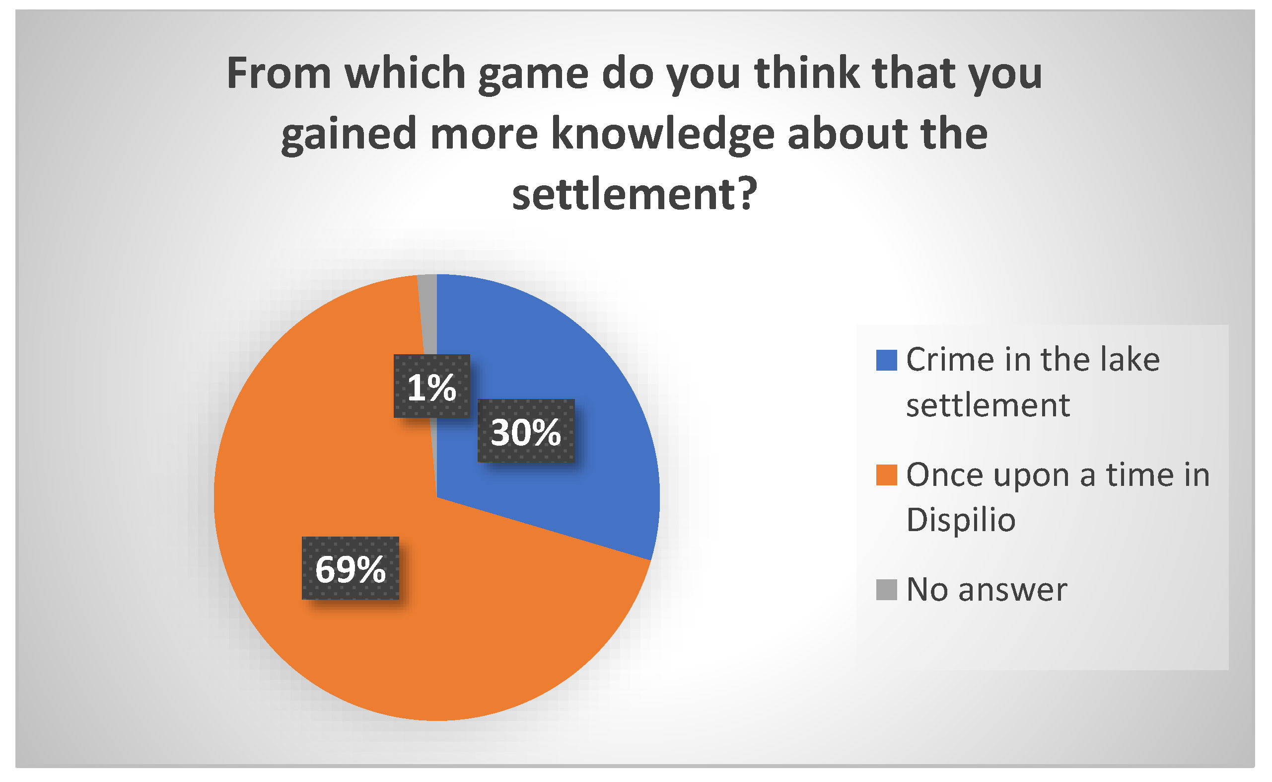
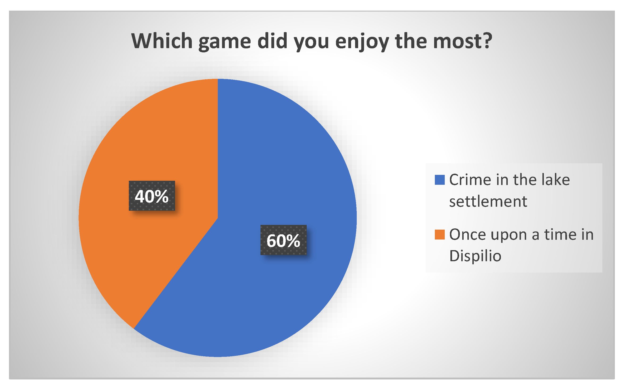
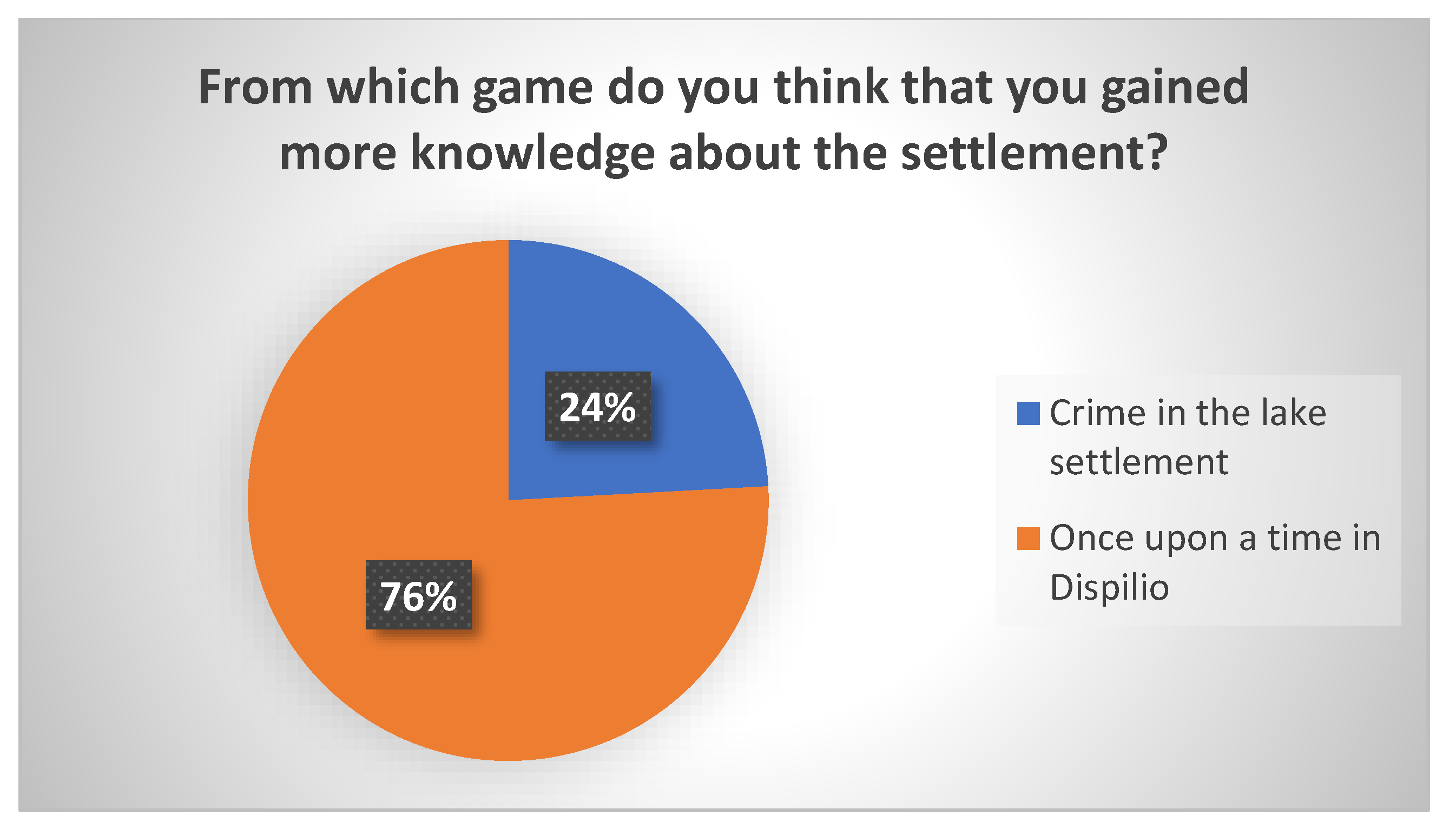
Students were also posed with two straightforward questions. They were asked which game they enjoyed the most and from which they think that they gained more knowledge. The results can be seen in
Figure 20 and
Figure 21.
A large percentage of students (69%) answered that they enjoyed the storytelling game “Crime in the lake settlement” more, but they thought that they gained more knowledge about the prehistoric settlement from the informative game “Once Upon a Time in Dispilio” (again, 69%).
The comments provided in the open-ended question were also analyzed. The majority of the comments were positive for both applications, and it was evident that the applications were engaging for the students. The words “interesting”, “educational”, “fun”, and “exciting”, appeared many times in these comments. There were 59 responses for the informative game and 61 for the storytelling game. Some of these can be seen below:
Once Upon a Time in Dispilio (informative application)
“Very interesting game. I liked the informative feedback after each answer. I have learned interesting facts about the settlement”.
“I liked the game. You gain knowledge about the history of the lake settlement in an interesting way. I liked the fact that you collect points and complete a puzzle”.
“Nice game that gives you the opportunity to get to know the lake settlement in an interactive way”.
“It was an opportunity to get to know the Dispilio settlement through an application. The game had zero difficulties; all ages can use it with the only condition of having a mobile device”.
“It was an excellent application, and I will recommend it to friends and family”.
“I think that games are a fun way to gain knowledge. Furthermore, you retain this knowledge for a longer period than with other methods. I liked everything about the application”.
“Very good game that combines knowledge with entertainment. It’s easy to use, and I personally liked the fact that it uses a map and that you change location as you move on. I also liked the fact that you gathered points for every correct answer. This feature was motivating”.
Crime in the lake settlement (storytelling application)
“The game was entertaining, and it gave you the feeling that you were actually in the Neolithic era”.
“I liked the mystery. It was an interesting process trying to solve it”.
“The game was fun, entertaining, interesting and conveyed information in an interesting way”.
“The narration and the change of tone in the narrator’s voice was very theatrical and interesting”.
“It was interesting that knowledge about the settlement was conveyed through a story”.
There were also comments saying that the storytelling game is mainly intented for younger audiences, since the questions were easy to answer and sometimes too obvious for adults, and they would prefer the questions to be more difficult. A student also commented that the game uses storytelling to convey information which makes it appealing, especially for younger audiences, but the references made to various historical objects found in the excavations (e.g., figurines) are not accompanied by sufficient information.
7.2. Evaluation Results from the 58 School Students
What can be observed in
Figure 24 is that the overall evaluation scores received from the primary and secondary education students are higher in almost all the categories (besides ease of use) when compared to the scores acquired from the university students.
The categories that received the highest scores were “challenge” and “intention to reuse”. Students were willing to experience the application again, and similar applications for other archeological sites or places of cultural heritage interest, or a different topic altogether.
As it can be seen in
Figure 25 and
Figure 26, again, a large percentage of students (60%) answered that they enjoyed more the storytelling game, “Crime in the lake settlement”, but they think that they gained more knowledge about the prehistoric settlement from the informative game “Once Upon a Time in Dispilio” (76%). The results are similar to those obtained from the university students’ evaluation.
Several school students left their comments, and all of these were positive. A typical comment left by the students was that they would like to spend more time at the settlement in order to play more games.
8. Discussion
One of the study’s aims was to provide ideas and guidance to educators who would like to transform cultural heritage educational tours into augmented reality experiences. This study aimed to achieve this by proposing appropriate software tools for creating applications and design features that enhance the augmented reality experience. More specifically, the following steps were carried out:
The related literature was researched for software tools that do not require advanced programming expertise, and the capabilities of these tools were compared specifically for creating location-aware augmented reality experiences for cultural heritage education. In order to obtain sound knowledge about the affordances of the tools, the respective documentation was examined, third party applications were tested, and small prototype applications were developed. A more detailed comparison was carried out between Taleblazer and Metaverse studio. While both applications have their pros and cons, it was decided to use Taleblazer for the applications we created. Taleblazer was chosen mainly for its ability to create (a) applications that use custom maps, (b) applications that do not require an Internet connection during game-play, (c) applications that can be experienced or tested away from the physical location (simulation or couch mode), (d) applications where the “bump” or “tap to bump” distance can be configured for cases where users are required to get very close to GPS locations to observe relatively small objects—signs, exhibits, etc.
The related literature was also explored to understand the specific design features that would enhance a location-based augmented reality application. The application design aspects were also discussed amongst IT experts and experienced educators, and it was decided to utilize the power of gamification and storytelling. Both methods are known from the literature to increase engagement, motivation, and learning outcomes. Furthermore, location-based augmented reality applications for cultural heritage education should keep the focus of the users on the physical world also, so that they can observe and interact with monuments and exhibits of cultural heritage.
Therefore, we believe that educators were provided with ideas on how these features can be incorporated into location-based augmented reality applications. More specifically, in the presented applications, certain gamification elements were incorporated (i.e., points, awards, and a puzzle), and an example of how storytelling can be utilized was provided. In order to keep the users’ focus on the physical surroundings, questions were used frequently in the application scenario that required the users to observe their immediate surroundings to answer correctly.
An evaluation scheme was proposed for location-based applications aimed at cultural heritage education. The questionnaire was constructed by utilizing various models from the literature to measure the following aspects: “challenge”, “ease of use”, “educational usefulness”, “satisfaction/enjoyment”, and “interaction/collaboration”.
Two samples were utilized for the evaluation: a sample of 71 university students attending related courses (i.e., Digital Storytelling and Digital Media and Education) and a sample of 58 school students (primary and secondary education). The university students experienced the applications away from the settlement (couch mode) and evaluated this experience. The school students, on the other hand, experienced the application on-site using GPS enabled mobile devices. The findings show that the applications scored high in aspects such as perceived ease of use, satisfaction and enjoyment, and challenge in the university students’ evaluations. The scores were even higher in almost all categories in the school students’ evaluations. This could be attributed to the fact that the applications are better suited for younger audiences (which is also the main target audience) and the fact that the applications were experienced in the form that they were mainly designed for—that is, location-based applications that are best experienced on-site. Ease of use was the only category which the sample of university students scored higher, and this could be attributed to the fact that students of the particular department are well acquainted to digital media, and the fact that an extra effort may be needed to reach the exact locations when the application is executed on-site.
Both samples liked the storytelling application more, but at the same time they thought that more knowledge was gained through the informative application. It became evident also by the students’ comments that although the storytelling application was more fun and engaging, it did not provide as much information about the archaeological site as the informative application. Thus, the application creators need to incorporate more scientific facts about the settlement and the excavation findings in the storytelling game to have a better educational impact, but in a way that does not disrupt the excitement and fun induced by the story. An extra menu could perhaps be incorporated into the application, which would provide additional historical facts on demand about several aspects related to the story. Some university students also found the plot of the second application not suitable for adults and that some of the questions were too easy to answer. Therefore, another version of the storytelling game could be made, with more difficult questions, and a more serious story plot in order to satisfy older audiences. These actions would probably raise the evaluation scores in more senior audiences.
9. Conclusions
In this study, two location-based AR educational applications for a prehistoric settlement were presented, together with design considerations made in the pre-production phase (i.e., target audience, authoring tools, and game design).
The main contributions of the paper are the following:
The study contributes to the field of location-based AR applications for cultural heritage education. As mentioned, this is a research field with a rather small number of publications, but we also believe that it is a promising field, since these types of applications combine physical presence with digital information, and enhance the experience of a tour at places of interest regarding cultural heritage.
The study attempted to provide ideas and guidance to educators who would like to create similar applications—that is, applications that transform educational visits to archeological sites and museums into an augmented reality experience.
The study contributed to the limited number of studies that have made use of Taleblazer, a product of MIT, which is an easy-to-use tool with many capabilities. Taleblazer is a rather new tool, and by examining the literature and by searching the bibliographical databases, it became obvious that there are few research papers and projects that use this tool. In the recent literature review on augmented reality and gamification in education [
9], none of the studies that were examined made use of Taleblazer.
We used an evaluation scheme that was derived by examining various evaluation models from the literature and spotting categories that would apply to location-based AR applications.
The applications were evaluated using two sample groups (university and high-school students) which experienced the applications both on-site and off-site (couch mode). Results were promising and showed that the scores received by the two samples were above average in all categories. The evaluation also revealed certain issues that must be dealt with to improve the applications, especially the storytelling application, which proved to be more engaging and fun. The storytelling application would have to provide more historical facts about the archaeological site without disrupting the enjoyment induced by the fictional scenario, and another version of the story would have to be created for adult users who desire to experience a more serious story plot and questions (or challenges) of greater difficulty.
The applications will be experienced by large number of school students in the future, as well as tourists visiting the archaeological site. Their evaluation and feedback will be valuable in improving the applications and creating new cultural heritage education experiences. Furthermore, the research team intends to create more location-based AR applications for educating the students and the broader public about the rich cultural heritage of the city of Kastoria.

