Review

Travel, Sea Air and (Geo)Tourism in Coastal Southern England

School of Earth Sciences, University of Bristol, Wills Memorial Building, Queens Road, Bristol BS8 1RJ, UK
Tour. Hosp. 2025, 6(3), 155; https://doi.org/10.3390/tourhosp6030155
Submission received: 17 March 2025 / Revised: 16 June 2025 / Accepted: 1 July 2025 / Published: 15 August 2025

Abstract

From the 17th century, European leisure travellers sought novel experiences, places and landscapes; they explored them within the context of contemporary, but temporally changing, social norms. Amongst travellers’ earliest motivations were reportage, curiosity and recuperation in managed landscapes. From the late 18th century, images in art galleries and then guidebooks directed leisure travellers into ‘wild’ places. Supporting and part-driving these developments were travel and antiquarian publications. That normalisation of ‘wild places’ exploration coincided with natural history’s popularisation. From the early 19th century, geosites were recognised, scientifically described, and popularised through a range of publications; this marked the beginning of geotourism. This can be contextualised within the rise in resort-based coastal tourism. These various themes are explored in relation to ‘Coastal Southern England’, an important tourism region from the early-18th century. By the Great War’s (1914–1918) close, its tourism patterns and nature, recognisable in present-day offerings, were established. Its development as a geotourism region can be conceptualised through the ‘travellers’ gaze’ and ‘adapted comfort zone’ models. Early geotourism literature and artistic representations, along with their creators’ biographies, could underpin modern geo-interpretation, of which some exemplars are given. General conclusions are drawn and future research suggested.

1. Introduction

1.1. Modern Geotourism

Landscape tourism promotion predates geotourism, but both were “… done from around the middle of the 18th century, for … an educated discerning elite. It is when we consider … a mass audience, from somewhere around the middle of the 19th century onwards, that … modern geotourism emerges.” (Hose, 2021, p. 24). Geotourism’s initial UK, Europe and wider afield roots were noted early (Hose, 2016, 2021). The original geoparks proposal (UNESCO, 2000) incorporated the seminal geotourism definition (Hose, 1995); it led to geotourism’s most influential movement, the UNESCO Global Geoparks (Henriques & Brilha, 2017). In April 2025, this had 229 geoparks across 50 countries, with 9 in the UK; most are focussed on aesthetic landscapes (Hose, 2010). Unfortunately, “… considering geoparks and geotourism as equivalents, is quite prevalent. This may cause confusion in written articles, book chapters… a holistic definition of geotourism covers more attractions … geotourism is an independent scientific and research subsector in itself …” (Sadry, 2021, p. 10). For this regional study, geotourism, depending on its geosites’ focus, lies between two definitions: 1. knowledge-based tourism, an interdisciplinary integration of the tourism industry with conservation and interpretation of ‘abiotic nature’ attributes, besides considering related cultural issues within the geosites for the general public (Sadry, 2021, p. 11), and; 2. the provision of interpretative and service facilities for geosites and geomorphosites and their encompassing topography, together with their associated in situ and ex situ artefacts, to constituency-build for their conservation by generating appreciation, learning and research by and for current and future generations (Hose, 2012, p. 11).

1.2. Unaware Modern Geotourists

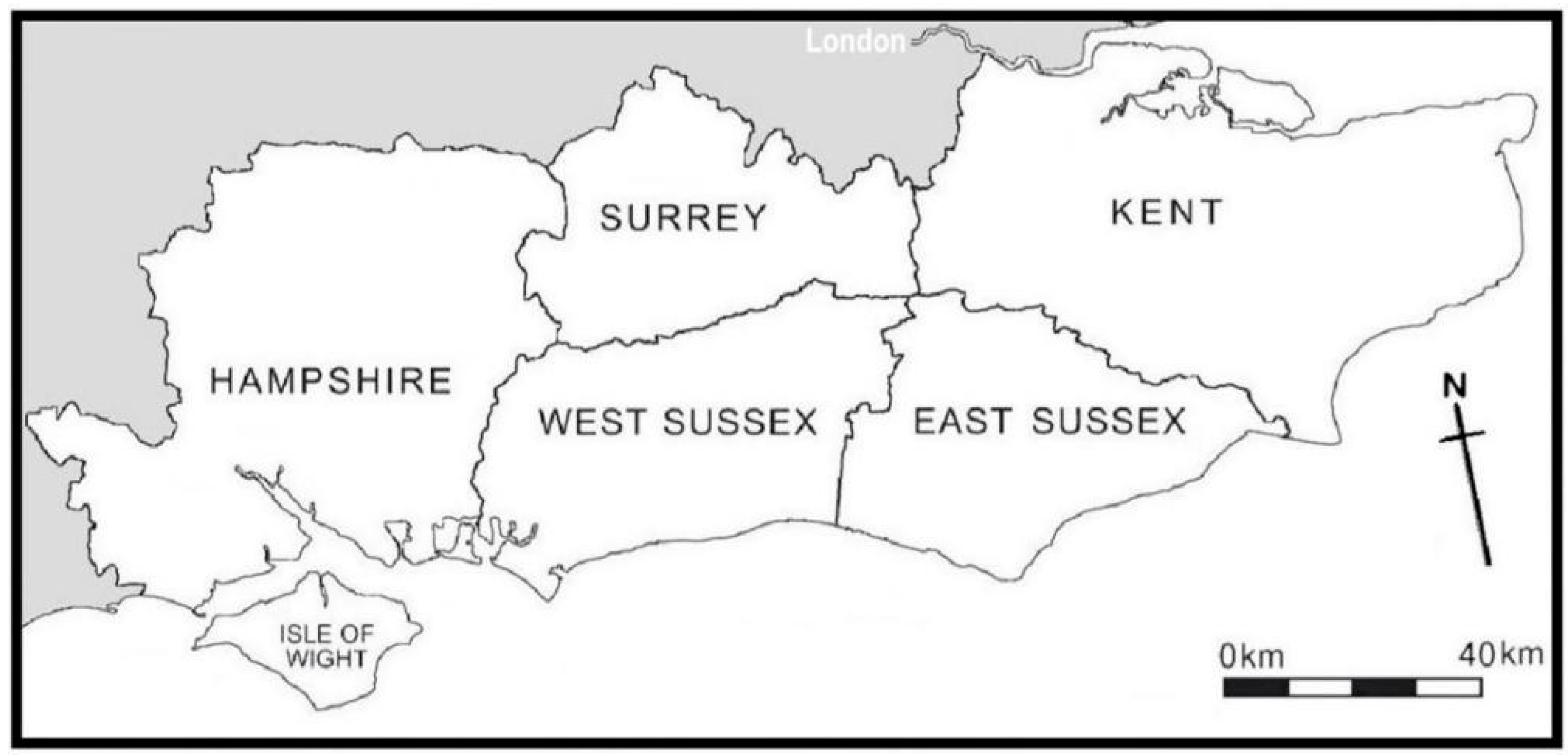
Most geotourists are unaware of geotourism’s evolution in the areas they visit and likewise the background to the selection of their geosites. They are generally unaware of the social convention adjustments required for outdoor natural history (including geology) study to become acceptable first to the social elite and then the middle classes (Allen, 1994, Chapter 2) and likewise their predecessors’ travel travails (Joyce, 1967). The relationship with early landscape tourism is also unknown; likewise, the influences of landscape art and travel writing in the recognition and promotion of their geotourism areas. Yet this information can underpin geo-interpretation, particularly for non-geologists, in today’s mass tourism areas, protected area landscapes, and geoparks; there is little evidence that has happened. These various issues are poorly addressed by present-day geotourism studies; they are best illuminated by considering specific seminal tourism, and later geotourism, areas. Hence, this study offers a summary narrative of geotourism’s development in the English region significant to both early coastal tourism and geological investigation, ‘Coastal Southern England’ (Figure 1). It is partly where modern geotourism was recognised and defined (Hose, 1995).

2. Coastal Southern England

2.1. The Region Delineated

Coastal Southern England encompasses a narrow (25 km-wide) strip of the counties of Hampshire (historically incorporating the Isle of Wight), Kent, East and West Sussex, and—because some routes to the coast traverse it—parts of Surrey. It includes the 2010-designated South Downs National Park and the October 2024 launched Cross-Channel Geopark (Figure 2). Kent Downs National Landscape and Parc Natural Regional des Caps et Marais d’Opale are jointly bidding for the latter’s UNESCO accreditation; the former’s (Kent Downs National Landscape, n.d.) website states: “The UNESCO brand brings sustainable benefits … developing local pride … new nature-based experiences to benefit local communities and economies …”. That website acknowledges the chalk geoheritage, although the interpretive focus is how geodiversity underpins biodiversity; it is “… the soaring chalk cliffs and the intricate microhabitats of rockpools … ancient bluebell woods, farmland, wildflower-rich chalk grassland …”. Its bilingual (English and French) geosites map highlights over 40 sites from England’s white cliffs of Dover to the ancient landscapes and ceramics museum of Desvres, France; but, many of its geosites lack geological interest. Folkestone is its main geotourism hub; its authority’s webpage (Folkestone and Hythe Borough Council, n.d.) excellently covers local geology, noting that Folkestone “… has given rise to a rich history including some of the earliest geological studies …”.

2.2. The Region’s Geology

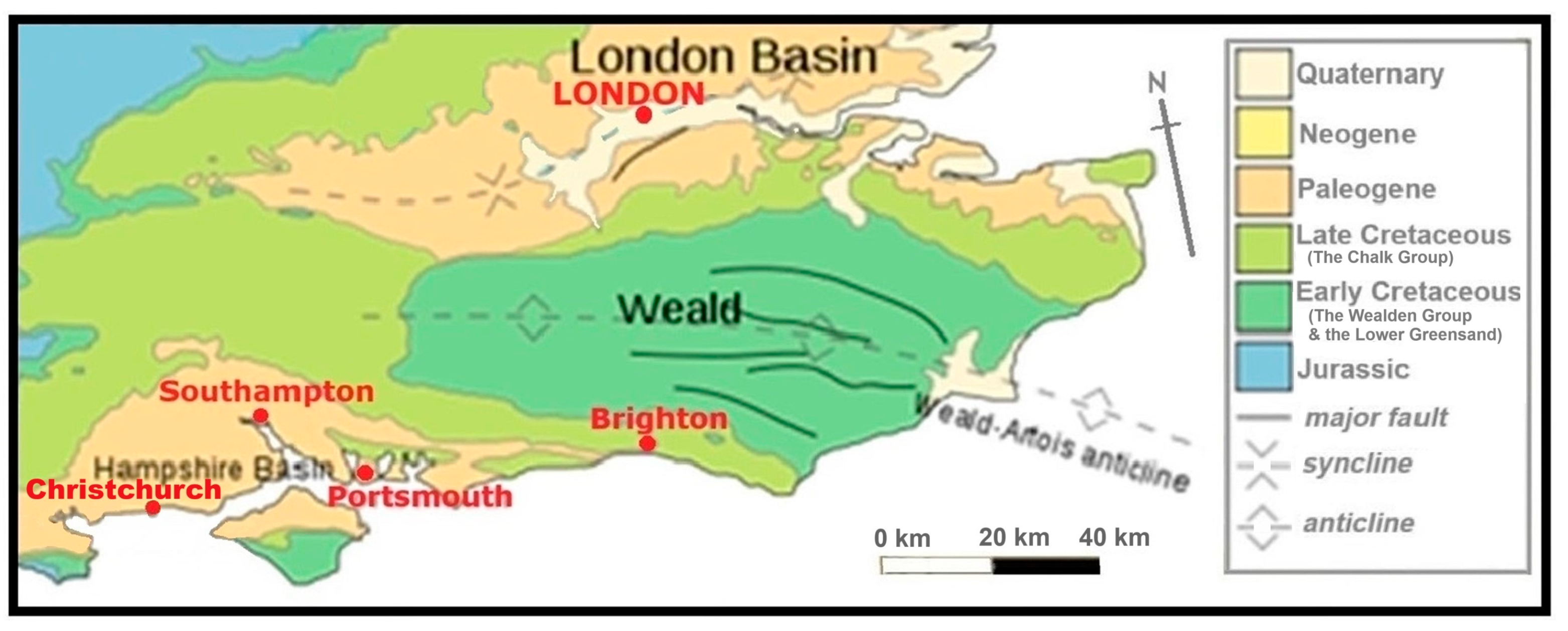
Its varied solid geology (Figure 3) is dominated by Cretaceous Period (66–143 million years old) ‘Wealden’ and Lower Greensand (clays, siltstones and sandstones) and Chalk Group (chalk and marls) rocks that form high ground and coastal cliffs. Palaeogene Period (23–66 million years old) rocks (mainly clays and sands) form the lower ground. The Isle of Wight is a discrete physiographic unit, with Wealden, Lower Greensand and Chalk Group rocks complementing those of Hampshire, Kent and Sussex; it is the region’s southernmost limit. Kent’s Isle of Thanet peninsula, with Margate (Figure 4a), formed from Chalk Group limestones demarcates its easternmost limit. Barton on Sea, immediately east of Christchurch, demarcates its westernmost coastal limit. In each county, the chalk forms their highest points in the Downs; Surrey’s 270 mBotley Hill in the north and West Sussex’s 280 m Blackdown in the south. The chalk forms the Isle of Wight’s highest point, at 241 m, on St. Boniface Down.
The solid geology and geomorphology have long provided textbook illustrations (Davies, 1914; Duszyński & Migoń, 2020); for example, ‘Toad Rock’ (Figure 4b) and ‘The Needles’ (Figure 4c). The Sussex and Isle of Wight Wealden Group and Lower Greensand quarries and coastal outcrops significantly contributed to dinosaurian palaeontology’s early advancement (Dean, 1999); for example, Hastings (Figure 4d).

2.3. A Much Visited Region

The region has been recorded in publications by travellers, then tourists and some geotourists from the mid-16th century to the present-day. From the mid-18th century, it attracted travellers seeking leisure and recuperation at inland spas and coastal resorts. It early attracted leading geologists’ studies. Their publications from the 1800s onwards are now classics; its easy access from London and the emerging metropolitan geological scene aided their creation. In the 19th century, it attracted multitudinous pleasure-seeking excursionists from the London area by steamers and the railways; such conveyance major usage persisted up to the Great War, after which motor-cars, buses and coaches (Hibbs, 1989) were adopted by, most notably the Geologists’ Association’s (GA) (Green, 1989), excursionists. Its initial geotourism development timeframe then terminates with the Great War’s (1914–1918) end; by then, much of what is the present-day offering was developed. The succeeding years have merely reinforced traditional tourist routes, seen the expanded urbanisation of its resorts, and the emergence of the modern geotourism offer (Hose, 2016).

3. Research Methods and Materials

3.1. The Research Questions

The study’s underlying hypothesis is that Coastal Southern England’s geotourism originated in health and cultural tourism’s evolution aiding field geology’s emergence. Its main research questions are: why, when and how did a cluster of southern England counties become a focus of early significant geological enquiry and develop into a major domestic tourism and minor geotourism region? A minor question was how might the study’s findings influence present-day geo-interpretation?

3.2. A Historical Qualitative Approach

A historical approach best facilitates the study of past events that have moulded the present; a qualitative social science methodology was adopted because “… gaps in the record mean that we can never know everything about the past—and thus a certain amount of art and interpretation is necessarily a part of history …” (Cole et al., 2022, p. 2). Whilst James Hutton’s (1726–1797) geological maxim is ‘the present is the key to the past’, to understand the emergence and rise in modern geotourism in Coastal Southern England ‘the past is the key to the present’. The distinction usually made between the ‘past’ and the ‘present’ as discrete entities bypasses the complexities of temporal interrelationships, but questions historical methods’ efficacy in exploring how contemporary phenomena adopted their present-day characteristics; that is, “… little beyond the purely factual can be proven or disproven absolutelyand that only as far as the records are complete and accessible… Historians convince—or fail to convince—their audience … by the facts at their command and their ability to argue pursuasively …” (Shiflett, 1984, p. 390). Hence, this study is characterised by source compilation, distillation, evaluation and narrative preparation.

3.3. The Literature

Historical studies necessitate primary (e.g., journals and guidebooks) and secondary (e.g., newspapers and textbooks) literature’s systematic study through qualitative content analysis; texts are accepted as probably reliable evidence from and about the past scrutinisable for their veracity. Naturally, “The process of identifying an appropriate body of primary sources is induced by considering what sources are most likely to answer specific research questions.” (Sager & Rosser, 2015, p. 203). Primary literature sources were selected on the basis they were publicly available within the study’s historic timeframe. Secondary sources were modern reviews and critiques. Original and secondary travel and geological literature was examined during in-library searches; the Geological Society of London’s library was the major source of antiquarian geology and topography volumes. Most of the secondary hard-copy tourism sources, many held by the author, are available at the British Library, London. A remote desktop study identified and sourced additional out-of-copyright volumes; most notably from the ‘HaithiTrust’, ‘Internet Archive’ and ‘Project Gutenberg’ websites.
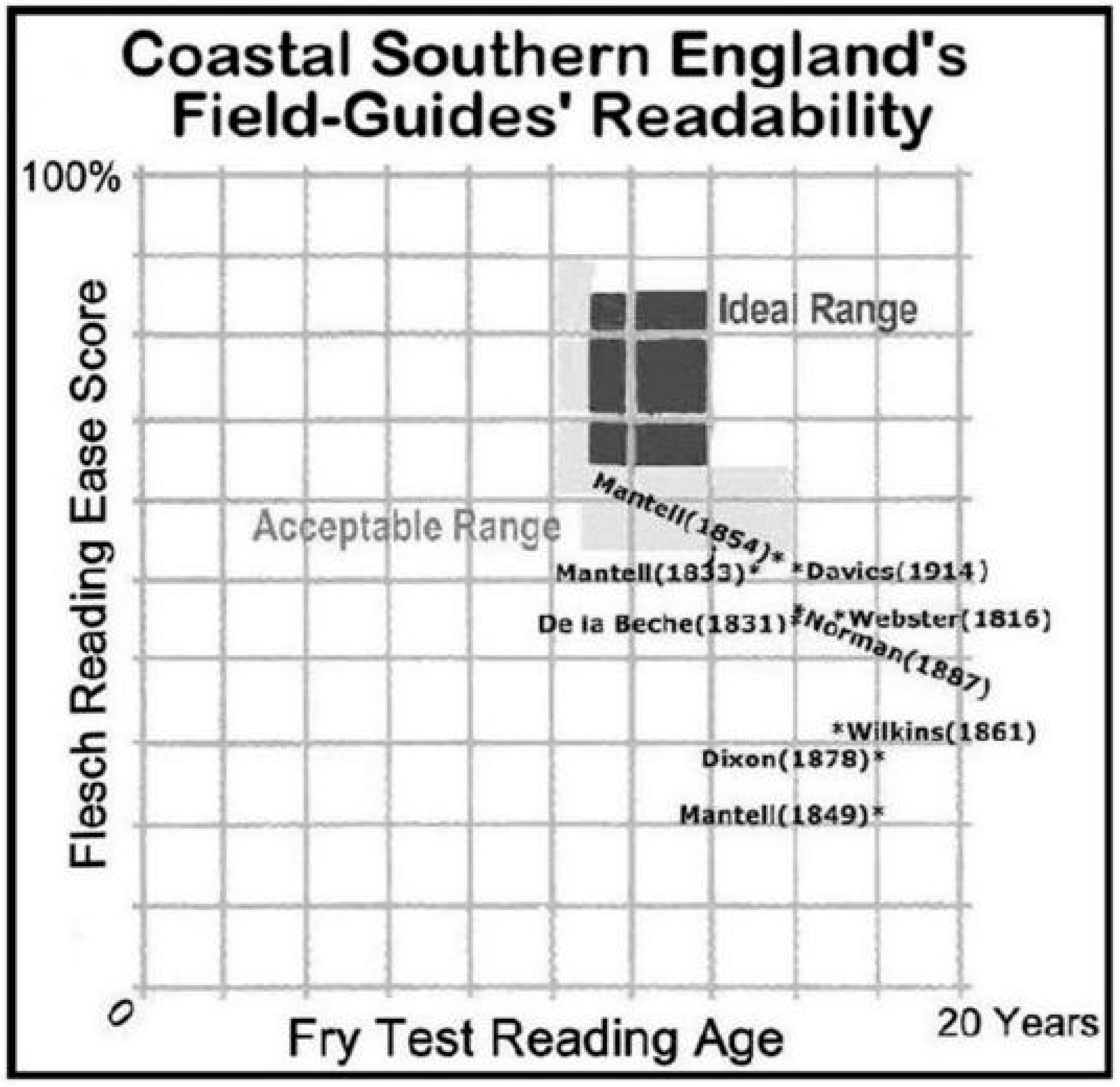
All volumes were scan-read and visually/electronically searched for key purposes (e.g., reportage, diaries, antiquarianism and travel writing), personalities (e.g., artistic, historic, literary and scientific), geosites, locations (e.g., touristic and artistic), topics (e.g., health tourism and transport), and concepts. Readability analysis of text extracts of some regional geology volumes was undertaken. The ‘Fry Reading Ease Score‘ and ‘Fry Test’ (available in ‘Micrsosoft 365’) were employed; their values were plotted on a twin-axis graph to show their efficacy.

3.4. The Artworks

Visual materials were selected on their contemporary availability as originals and/or reproductions within the study’s timeframe. Painters’, illustrators’ and photographers’ works produced, particularly by significant individuals, within the study’s timeframe were examined, as originals in the region’s and London’s public art galleries and museums. Published reproductions were examined in travel-guides and guidebooks (including their frontispieces, endpapers and in-text illustrations), and postcards for graphics that supported the study’s emerging themes; artbooks, and online sources supplemented that material. They were assessed for their content and approach, particularly their landscape depiction accuracy versus its interpretation; exemplars were selected that best encapsulated the study’s, especially interpretive, themes.

3.5. Fieldwork

Fieldwork, spread across 2010–2023, assessed and digitally imaged some historic journey routes and places; it checked whether the routes could be readily traced and possibly recreated. Fieldwork, from 2018 to 2023, assessed and digitally imaged some of the GA’s pre-Great War excursions. This checked whether their routes could be readily traced and possibly recreated; it also condition-monitored their geosites.

3.6. Conceptual Models and Themes

The garnered material was related to two conceptual models, the ‘Travellers’ Gaze’ and the ‘Comfort Zone’, that underpinned the exploration and explanation of four intertwined themes; the role of: 1. The travellers/excursionists and their motivations; 2. The travel and geological literature, and its role in encouraging outdoor study; 3. Artists’ visualisation’s role in popularizingthe region; 4. The role of transport infrastructure improvements in making the region accessible.

4. The Results

4.1. Leisured Visitors

4.1.1. Early Solo Travellers

Early solo travellers’ observations introduced the region to later excursionists; these were initially diarists when “The habit of touring … [was] a Tudor phenomenon… the motive force was pride in the greatness of Tudor England, and a curiosity both in the historic roots of that greatness and its contemporary manifestations… it became a popular pastime amongst gentlemen of leisure to travel for weeks, even months, in the discovery of their own country.” (Moir, 1964, p. xiii). Around 1540, one of its first named travellers, John Leland (1502–1553), when recording religious houses’ libraries for Henry VIII (1491–1547) noted that Margate was a decrepit village; John Evelyn (1620–1706) recorded Margate was still decrepit in 1672. Daniel Defoe (1660–1731), explored, with a keen topographic eye, Kent’s Isle of Sheppey; it was where “… chalk hills come close to the river, and from thence the city of London … even Holland and Flanders, are supply’d with lime …” (Defoe, n.d., p. 99). In the 17th century’s last decade, Celia Fiennes (1662–1741) to regain her health rode through England, including Kent (Morris, 1949) and eventually crossed to the Isle of Wight. Her diary records she travelled up to 50 miles (80.5 km) on long summer days; much less in winter, when roads were muddy ruts across the landscape.
Defoe, Fiennes and later William Cobbett (1763–1835) recorded (as their class’s main interests) agriculture and accommodation, plus places of antiquarian and architectural interest. Eighteenth century travel was restricted because “Getting around was difficult, and expensive. It was only with the arrival of maps and guidebooks, the creation of the turnpikes and the improvements to the technology of the stagecoach … that even many of the elite began to travel.” (Flanders, 2006, p. 211). Mounted, and hence wealthy, travellers commonly rode their own horses, costing some £30 (over £3200 today) annually around the 1800s to maintain; they also hired them from the principal roads’ inns (Joyce, 1967, Chapter 1). Yeomanry (volunteer mounted troops active from the 1790s to the 1850s) training of middle-class men involved extended camps into ‘wild’ areas. Until travel’s poor reliability and slowness were addressed, the market for travel literature was small and coastal tourism’s development much hampered.

4.1.2. Coaching and Railway Travellers

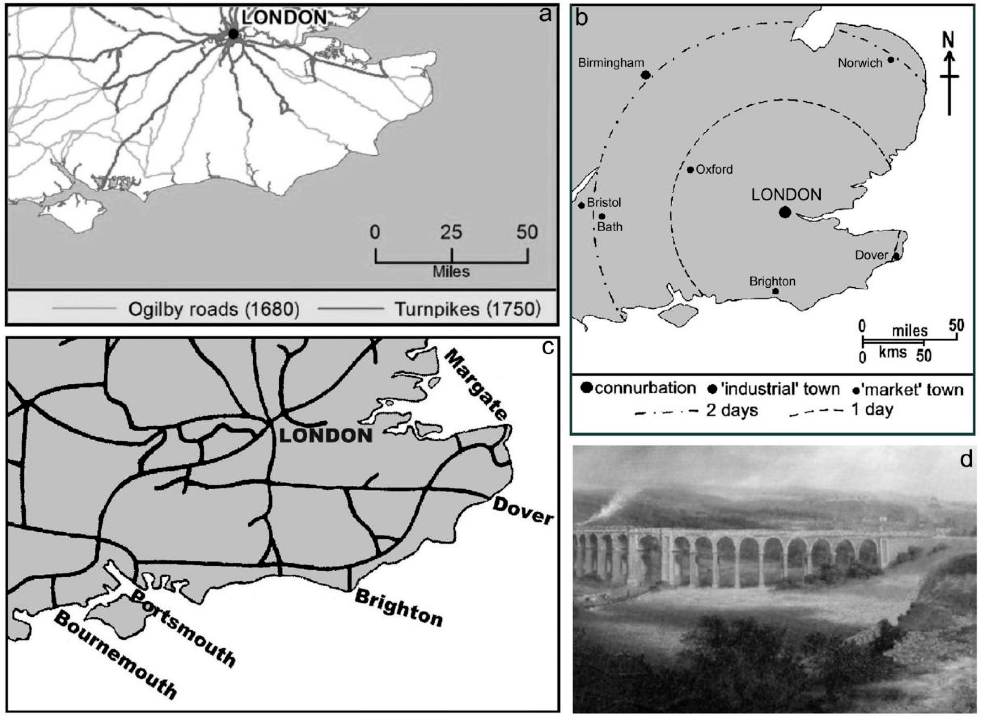
From the early 18th to the mid-19th centuries, regular horse-drawn coaches running on turnpikes (Figure 5a) (Joyce, 1967, Chapter 2), comfortably and reliably linked the region’s resorts to London (Figure 5b); some journey times were halved. Between 1700 and 1800, some 1600 turnpikes were opened (Briggs, 1983, p. 207) in England and Wales. Away from them, poor surfaces persisted into the 19th century; for example, in August 1823 Cobbett’s horse sank almost to its belly (Cobbett, 1957, p. 203) on a clay road near Selbourne, Hampshire. Therefore, it was often quicker and more reliable, despite the vagaries of wind and tide, to sail from the Thames ports to the south coast resorts; in the late 18th century Brighton, Broadstairs, Margate and Ramsgate were popularised by hoys (flat-bottomed sailing barges) and then steamers. Margate had a boat jetty by 1800 and a pier from 1855; 50,000+ passengers embarked from it in the 1820s, 85,000+ in the 1830s, and 100,000+ in peak years (Waller, 1983, p. 132). That waterborne trade introduced concessionary fares, later adopted by the coaching companies; it also issued pre-printed tickets endorsed before travel, a practice later adopted by the railways.
The railways’ spread (Turnock, 1998, Chapter 3) (Figure 5c) from London to the south coast was particularly recorded in Bradshaw’s timetables and guides (Bradshaw, 1861/2014); it opened up ‘wild’ places and their geosites to excursionists with the speed and reliability previously unattainable. There was a downside to the railways because “Well-informed curiosity, a real love of the English countryside and a willingness to undergo considerable discomfort … were undermined by the coming of the railways… as travel became easier it became available to a much wider mass of people, and … lost much of its character as a venture of personal discovery…” (Moir, 1964, p. xv). Railways were the GA’s major excursion routes (Green, 1989), particularly with concessionary fares. It even organised railway engineering site excursions; these sites much impacted rural landscapes (Figure 5d) whilst exposing their underlying geology. Its first ever excursion, in 1860, to Folkestone (Anonymous, 1860) used a South Eastern Railway special train; that company’s line reached Folkestone in 1843 and Dover in 1844. London was linked to Brighton in 1841, Lewes in 1846, Hastings in 1851, Portsmouth (for the Isle of Wight) in 1859, Dover in 1859, and Margate in 1861.

4.2. For Health and Art

4.2.1. Londoner’s Coastal Recuperation

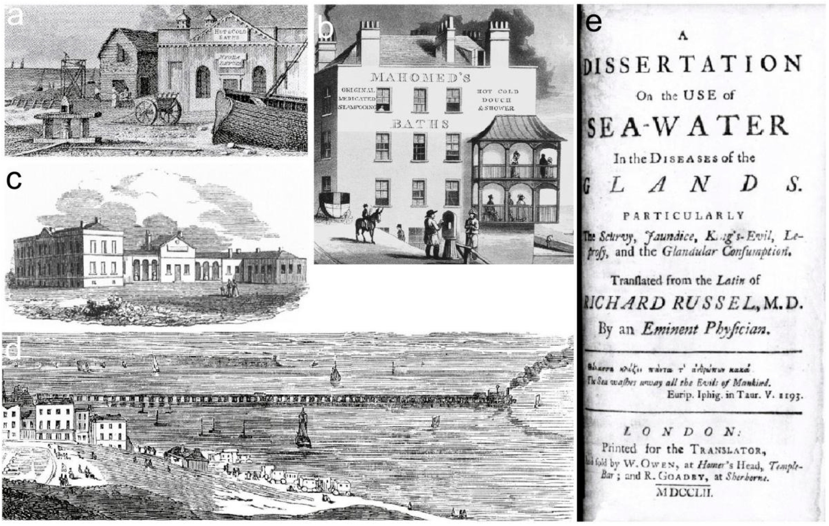
The region was popular from the mid-18th century with London’s social elite seeking recuperation. Concomitantly it was popular with artists seeking inspiration. This was when few visited the sea because “… roads were poor and few, and the coast … inaccessible, with little fishing villages tucked away at the foot of steep cliffs, or at the end of rough and muddy tracks.” (Gordon, 1972, p. 40). In 1736, the Rev. William Clarke spent a month sunbathing and swimming at Brightelston; by the late 18th century it was part of then fashionable Brighton. An early Sussex travelogue (Highmore, 1782) reports its author used one of the 254 sea-bathing machines there (Highmore, 1782, pp. 26–28). Dr John Awsiter opened Brighton’s indoor baths (Figure 6a) in 1769. Dean Mahomed (1759–1851) opened his ‘Indian medicated vapour baths’ (Figure 6b) in 1821; he published patients’ case histories (Mahomed, 1826) to prove their efficacy.
A decade earlier it was recorded that Brighton had “… a great number of real or fanciful patients tired of London, or anxious to give the slip to their doctors; as well … thousands of convalescents despatched thither by the doctors themselves.” (Granville, 1841, p. 560). Nearby resorts relied upon their climate for tuberculosis recuperation; in the 19th century “The invalid condemned by his medical adviser to seek a milder climate on the Sussex coast, who with his lungs threatened, flesh wasting … proceeds either to Hastings or St. Leonards, in hopes of recovering the lost health, or the better to husband the little of health and life he has left …” (Granville, 1841, p. 584).
A 1736 Kentish Post news-sheet announcement (Aslet, 2005, p. 78) promoted Thomas Barber’s Margate indoor sea-water bath. In the 1790s, Dr John Anderson enthused about Margate’s 1796 Royal Sea Bathing Hospital (Figure 6c); it pioneered systematic sea-bathing treatments (Gray, 2006, p. 10) and only closed in 2001. Margate’s Clifton Baths, built 1824–28 for £15,000 (today, £1.9m), tunnelled through the chalk cliffs creating massive sea defences. Herne Bay was created with the £50,000 (today about £4.7 million) 1832 Royal Pier (Figure 6d); the Pier Hotel, with a promenade opened in 1837. The steamer ‘Venus’ inaugurated the Herne Bay to London service in 1832. Dr Richard Russell’s (Russell, 1752) and Awsiter’s (Awsiter, 1768) publications, so instrumental in promoting sea-water treatments, had initiated the rise in coastalhealth tourism.

4.2.2. Renowned Painters and Their Landscapes

With present-day attitudes to landscape considerably different to those of the 17th to 19th centuries, artists’ struggles to sell their paintings to patrons are difficult to comprehend; their ‘wild’ landscape paintings were not of tamed agricultural and parkland views preferred by patrons. However, the Grand Tour (Black, 1993, 2003; Vaughan, 1999) had introduced the Italian classical romantic school of landscape depiction; an approach particularly advocated by Claude Lorraine (1600–1682) and Nicolas Poussin (1594–1665), adopted by English artists (Stainton, 1985, pp. 7–16). Seventeenth century Dutch School artists, such as Aelbert Cuyp (1620–1690), exhibited numerous coastal scenes that influenced their English contemporaries. The emerging mid-18th century English Landscape School (Vaughan, 1999) influenced elite and some upper middle class travellers; they saw their works in private collections, auctions houses and the Royal Academy. Richard Wilson (1714–1782) and Thomas Gainsborough (1727–1788) were the School’s notable exponents. Many artists, notably JMW Turner (1775–1851), renowned for their oil paintings also worked in watercolours as the basis for widely publishedengravings (Shanes, 1990, pp. 8–21).
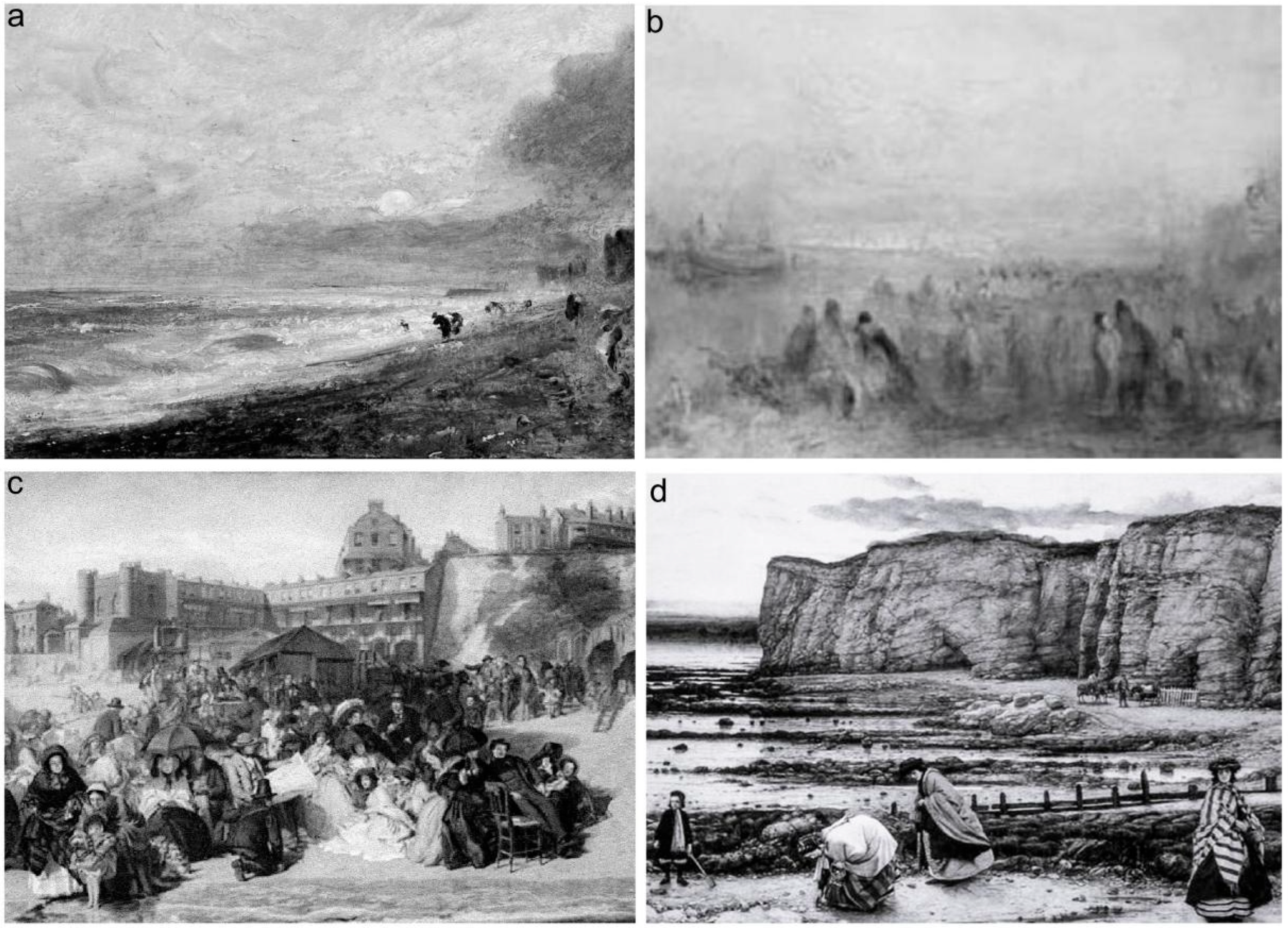
Artists influential in shaping public taste visited and resided in the region. By the early 19th century, the present-day recognised pre-eminent artists of ‘wild places’ were John Constable (1776–1837) (Parris et al., 1976), JMW Turner, and John Glover (1767–1849) (Hose, 2010). Their works showed some understanding of the underlying geology. They painted the coast (Hill, 1985; Shanes, 1981) and its hinterland within the rules of the contemporary cultural movements (Hose, 2008, pp. 42–43). Constable was rooted in rural England and fairly accurately recorded scenes; similarly Glover, but Turner, especially in his later years, tended to interpret them. Constable first visited Brighton in 1824, moving his family there for his wife’s health; he recorded local scenes such as ‘A Sea Beach, Brighton’ and Hove Beach’ (Figure 7a).
Turner well knew Margate and its environs, having been at school there from 1785 to 1788. He was a regular Margate visitor in 1827, travelling by steamer from London; he had lodgings there from then until 1847. He created over 20,000 drawings and paintings, of which 100 featured Margate’s harbour and its environs; notable amongst these is his 1835–1840 ‘Margate from the Sea’, c. 1840 ‘Waves Breaking on a Lee Shore at Margate’, and 1845 ‘Margate Harbour’ (Figure 7b). Turner also well knew Hastings and its environs; this was due to Mad Jack Fuller of Rosehill (1757–1834) who from 1810 supported him with many paid commissions; Fuller’s commissioned Views of Sussex was published in 1819. Turner returned to the area in later years, notably for his 1825 ‘Shipwreck off Hastings’ and 1835 ‘Line Fishing, Off Hastings’; the latter includes a view of the Thade and its sandstone cliffs.
However, the most contemporarily appreciated painters of the region’s local scenes were William Powell Frith (1819–1909) and Charles Dyce (1806–1864). Frith painted everyday-life scenes, such as ‘Ramsgate Sands’ (Figure 7c). Dyce’s iconic seaside excursion record is ‘Pegwell Bay …’ (Figure 7d). Steamers and the railways facilitated London-based artists’ recording of the region. They also encouraged writers to reside along its coast. Chief amongst these was Rudyard Kipling who lived (1897–1902) at Rottingdean near Brighton; he penned the poem ‘Sussex’, with its byline “Yea, Sussex by the sea!”. Rottingdean’s beach was noted by the region’s pioneering geologist, Gideon Mantell (1790–1852), for “… pebbles of agate, and chalcedony … collected by visitors … for bracelets and other ornamental purposes …” (Mantell, 1833, pp. 40–41). Thomas Hardy’s (1840–1928) fictional Wessex landscape-set (Morley, 1983, pp. 192–95; Robinson, 1984) writings (although he lived in Weymouth, Dorset!) subsumed the region’s western part and promoted its tourism.

4.3. Diaries, Travel-Guides and Guidebooks

4.3.1. The Bizarre and a Revolution

Eighteenth century travel into England’s ‘wild’ coastlands was thought somewhat bizarre, if not downright dangerous, by the public. The development of guidebooks and field-guides was influential in shifting opinion away from that view; that coincided with the late-18th century’s rising middle-class numbers and increasing national literacy. The latter was due to cheap mechanically printed and bound books; there was a concomitant revolution in book distribution with the opening of subscription and public circulating libraries (Thorndyke, 1920, pp. 25–26).

4.3.2. Early Travel Literature

Travel-guides were mainly personal reminiscences and diaries. Sir Henry Holland (1778–1783) commented in 1811 that “nobody you know, travels now a days without writing a quarto to tell the world where he has been …” (Barton, 1998, p. 3). It seemed natural for travellers to write about their travels; so “Long winter evenings were spent in transcribing the notes taken in the previous summer’s tour, and they produced their accounts, sometimes for publication, often for circulation in manuscript form amongst friends and neighbours.” (Moir, 1964, p. 1). Naturally, geology “… recruited travellers … it could not be undertaken without travel.” (Leed, 1991, p. 199); that travel, prior to mid-19th century geology field-guides, was informed by scientific papers and guidebooks. Guidebooks were “… a British and a German invention, people from those countries being the first to have the money and the intellectual curiosity to travel, at least in any numbers.” (Sillitoe, 1995, p. 221). They were produced for the (particularly in the classics) educated elite; they benefitted from innumerable 18th century antiquarian publications; most were lavish library volumes. Most antiquarians believed “… antiquarianism was only suited to gentlemen of education” (Sweet, 2001, p. 189). The elite were a much smaller market by the mid-19th century than the lesser-educated middle-classes. The 1707 foundation of the Society of Antiquaries led to a county-based antiquities survey; this was largely completed by the 19th century’s opening. Its material was summarised in even populist guidebooks.

4.3.3. Railway Guidebooks

The railways helped to expand the guidebook market; they were keen to lure excursionists onto their commuter lines, particularly at weekends. Surprisingly, the major railway guidebook series was published by Sir George Samuel Measom (1818–1901), not the railways. From 1852 he published The Official Illustrated Guide to …; those for the region (Measom, 1853, 1858) included resort and landscape descriptions, with some geological information. Examples of the former are Ramsgate where “The sands are excellent for bathing …” (Measom, 1858, p. 279) and “Three miles of lofty cliff, grassy hill, firm road, and shifting shingle brings the pedestrian to St. Margaret’s Bay …” (Measom, 1858, p. 275). An example of the latter is the Isle of Wight’s Undercliffe where a “… series of terraces formed by the upper strata … have slipped down from the cliff and hills above …” (Measom, 1858, p. 80); its spa use was earlier recorded because “ … it boasts of a chalybeate water [the Sandrock Spring] … on the Undercliff … strongly impregnated with alum and the green vitriol … in the midst of that romantic and wild scenery …” (Anonymous, 1859, pp. 546–547).

4.3.4. The Guidebook Series

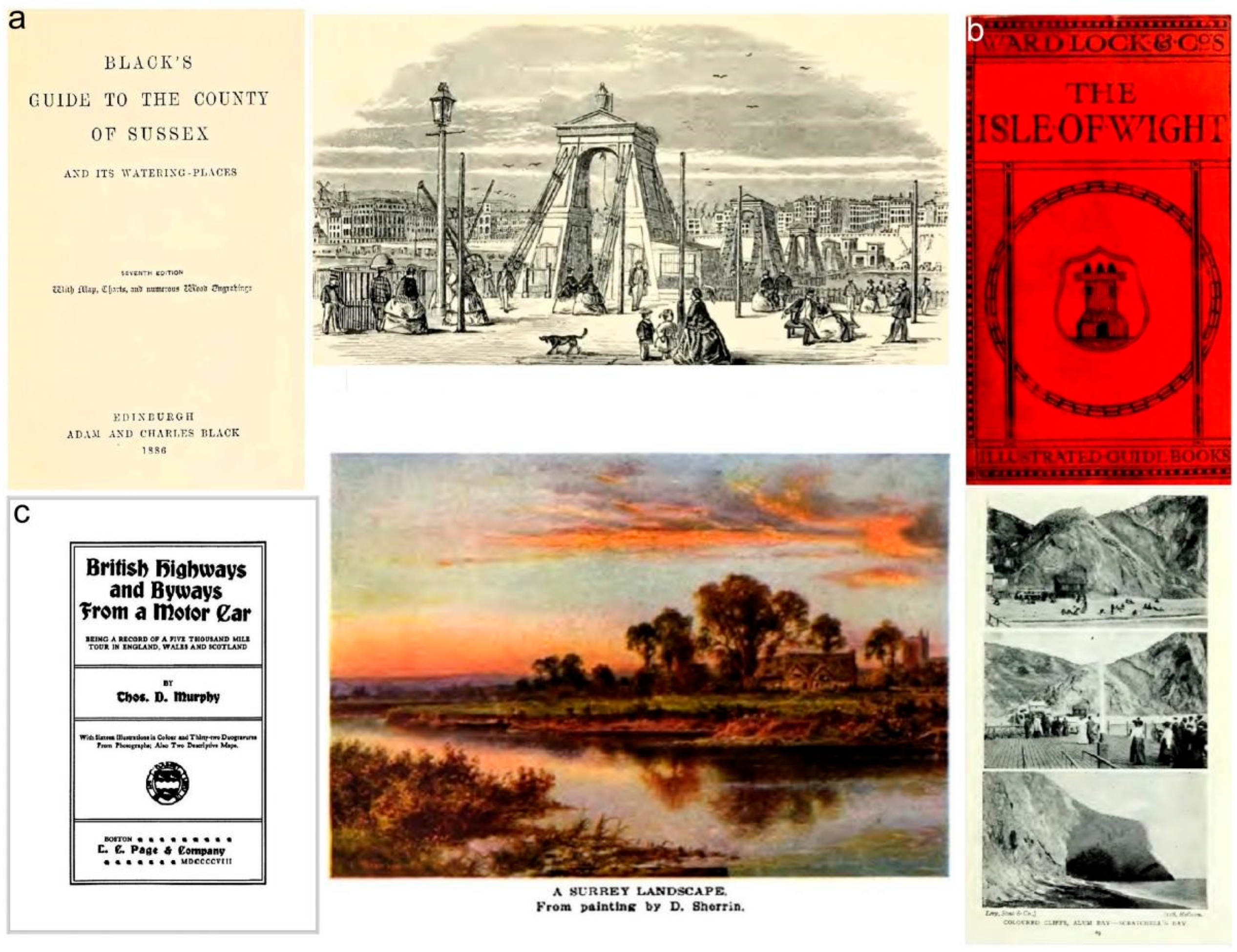
From the 1830s, several publishers recognised the commerciality of regional travel guides in a common easily recognised format, or series. John Murray’s 40-volume ‘Handbooks’ (published 1838–1911) covered accommodation, historical, and topographic information. Adam & Charles Black published (1839–1919) the ‘Guide Book for Tourists’ series; by 1876 there were volumes for Hampshire, the Isle of Wight, Kent and Sussex (Figure 8a). The nearly 90-volume chiefly town-based Ward Lock ‘Red Shilling Guides’ had 20 (published 1880–1917) for the region—Brighton and the Isle of Wight in 1880 (Figure 8b) and Margate and Herne Bay in 1899. Macmillan’s 24-volume ‘Highways and Byways’ series (published 1898–1948) covered Hampshire (in 1908), Kent (in 1907 and 1914) and Sussex (in 1904). They were initially intended for wealthy and literate Edwardian travellers, as exemplified by the 1908 Highways and Byways from a Motor Car … (Figure 8c). Mountford John Byrde Baddeley (1843–1906) initially published his 20-volume ‘Thorough Guides’ from the early-1890s to the 1910s; the region’s 1895 Isle of Wight with notes for geologists & cyclists and 1897 Surrey and Sussex … were text-rich. The well-illustrated 50-volume Methuen ‘Little Guides’ (published 1899–1959) covered Hampshire (four editions, 1913–1920), the Isle of Wight (two editions, in 1904 and 1921), Kent (three editions, in 1913–1920) and Sussex (six editions, in 1900–1920).

4.3.5. In Summary

By the Great War’s close, the region was well covered by guidebooks suitable for all tastes and pockets. Many, by the 1840s, included some mention of geology; for example, Nelson’s (Anonymous, 1859) unillustrated tourist handbook had a 14-page geology appendix. Many reflected, particularly in their illustrations, that overwhelmingly urban Britons then, as now, “… have an affection for nature that is without parallel in the industrialized world.” (Mabey, 1986, p. 2). Further, The Gentleman’s Magazine and Historical Chronicle and similar periodicals, such as Punch, occasionally carried geology and tourism articles.

4.4. Some Geo-Publications

4.4.1. The London Factor

London was the centre of British geology reportage following the Geological Society of London’s 1807 establishment (Woodward, 1907) and the GA’s in 1858 (Freeman, 1992). The GA’s excursion programme (Table 1) and their reports in its Proceedings (Green, 1989), was summarised in two volumes (Holmes & Sherborn, 1891; Monckton & Herries, 1909). One’s Preface noted they were significant for “… geological sections … views … of the structure of the surrounding countryside; while the intending visitor … may learn … how to employ his time most profitably …” (Holmes & Sherborn, 1891, pp. vi–viii). The GA’s excursion reports are a rich source of baseline data on routes, geosites’ conditions, geological observations, and the excursionists’ experiences. The GA’s material was supplemented by trade directories’ geology accounts, notably the Geology of the Counties … (Harrison, 1882). Geological Excursions Round London (Davies, 1914) was similar in providing, as its Preface states, “… a handy guide … useful to many who are interested … and desire a field-acquaintance with the geological formations … To those who take pleasure in country walks the routes … will prove attractive …” (Davies, 1914).

4.4.2. Geo-Publication Types: Textbooks, Manuals and Field-Guides

By the mid-19th century, travellers could purchase an expanding range of illustrated natural history (including geology) textbooks and field-guides. The latter’s numbers provide a measure of the public’s interest in field study; this was enthusiastically pursued when there were numerous gifted amateur field naturalists with many local and regional societies to support them (Allen, 1994, Chapter 8; Burek & Hose, 2016). There were also some national—most relevantly the 1836-founded Botanical Society of the British Isles (Allen, 1986) and the 1876-founded Conchological Society of Great Britain and Ireland—societies providing support.
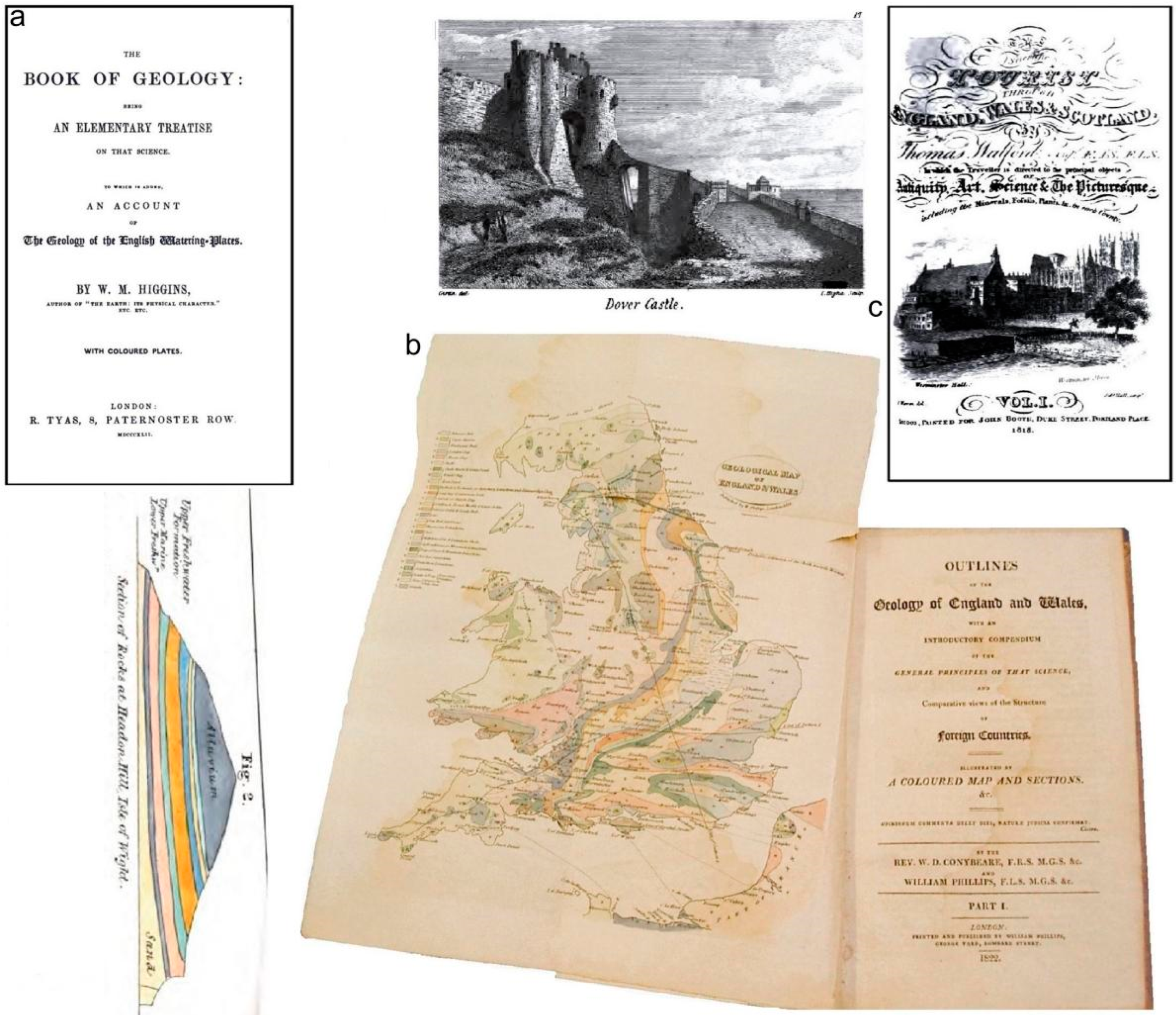
The Book Of Geology … (Higgins, 1842) (Figure 9a) had a detailed stratigraphy chapter. It included accounts of the Isle of Wight (Alum Bay, Headon Hill and Hordwell Cliff); it also had a table cataloguing Kent’s Chalk fossils. Its 40-page chapter ‘Geology of the Watering Places’ had accounts of Brighton, Dover, Folkestone, Hastings, Hythe, the Isle of Sheppey, Margate, and Ramsgate. Two major early textbooks were A Selection of Facts … (Phillips, 1818) and Outlines of the Geology … (Conybeare & Phillips, 1822) (Figure 9b); both incorporated locality descriptions. The former was the first compilation of stratigraphic knowledge. The latter, up to the mid-19th century, was the standard introduction to geology.
These volumes competed with generalist works such as Walford’s 1818 two-volume The Scientific Tourist … (Walford, 1818) (Figure 9c). This had limited geology coverage “… intended to point out such objects as are most worthy of notice of the antiquarian, mineralogical, and botanical tourist, or admirer of the sublime and beautiful scenery …” (Walford, 1818, p. iii); it also recognised “There are those who … travel for improvement; and … travellers who move about to kill time … but return home again as ignorant as they set out.” (Walford, 1818, p. v). It included practical advice on what tourists needed for fieldwork; it specifically mentioned a drawing box, pocket compass, pocket barometer, small hard chisel and hammer. It is mainly county-based accounts of principal localities; Margate was “a fashionable sea bathing-place” (Walford, 1818, p. 16) and Worthing “Is one of the best sea bathing-places in Britain, with a fine sandy beach …”. (Walford, 1818, p. 5). It briefly mentioned each county’s geologyy, such as: the Isle of Wight’s “Beautiful white sand is found near the Needles. Freestone near Quarr Abbey. Red and Yellow ochre and native alum in Alum Bay …” (Walford, 1818, p. 165) and: Kent’s Isle of Sheppey cliffs “… abound in extraneous fossils, most of them impregnated with pyritical matter” (Walford, 1818, p. 165).
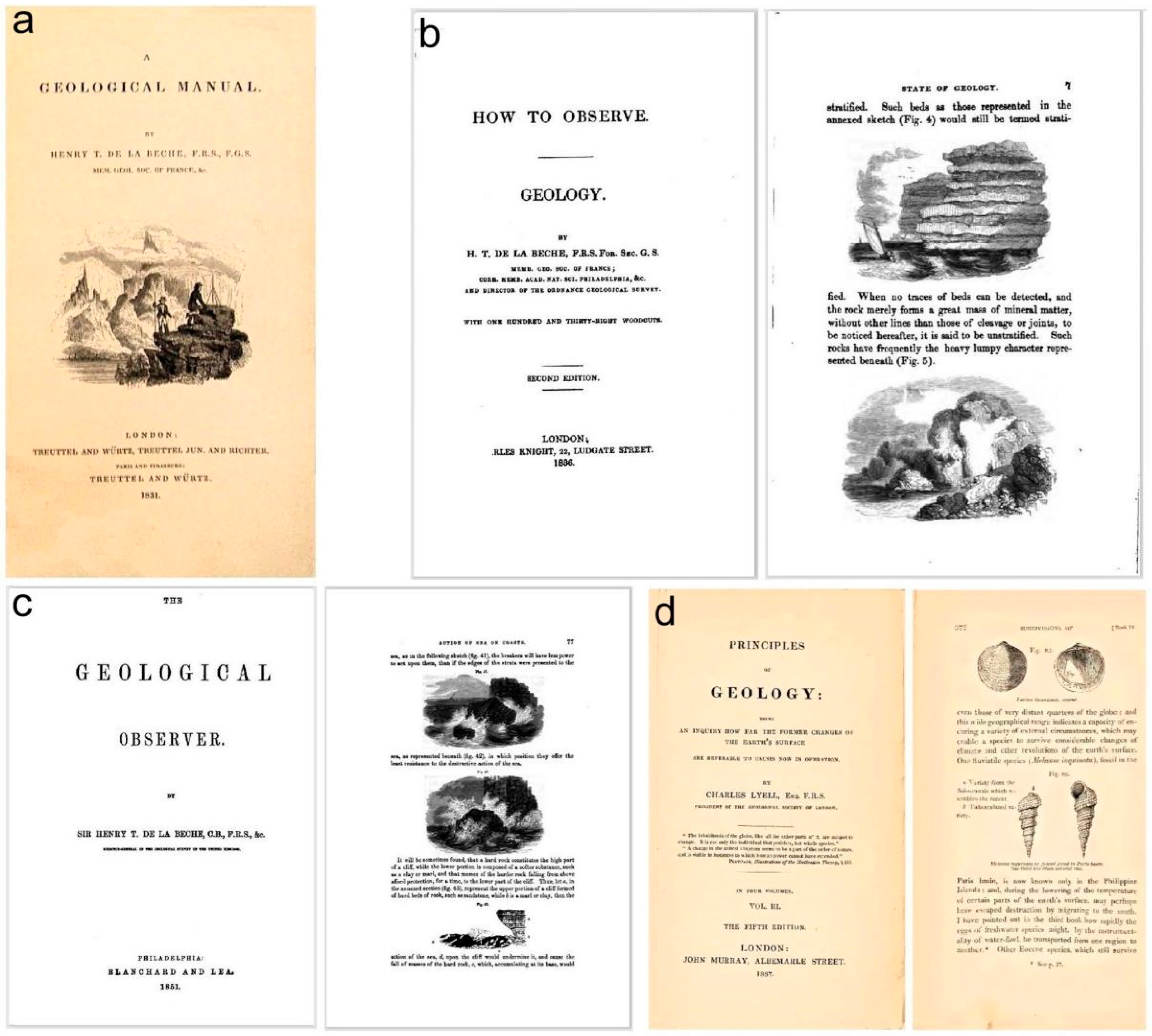
Geology field-manuals appeared around the 19th century’s second quarter; for example, De la Beche’s A Geological Manual (De la Beche, 1831) (Figure 10a), How to Observe (De la Beche, 1835) (Figure 10b) and The Geological Observer (De la Beche, 1851) (Figure 10c). Of the Geological Manual, the January 1832 The Gentleman’s Magazine … recommended it to “… every class of readers, as a work containing a vast fund of research and observation, embodied in a style of composition that might serve as a model to many scientific writers …” (Anonymous, 1832, p. 45). Concomitantly, Charles Lyell’s (1797–1875) planned four-volume Principles of Geology (Lyell, 1830–1833) (Figure 10d) was, over several editions up to the 19th century’s last quarter, the standard textbook; its content was not restricted to Britain and it was too bulky to be carried by excursionists. The two-volume 1844 Medals of Creation… (Mantell, 1844)] was a comprehensive introduction to fossils; its introductory pages suggested readers “… visit some of the localities described; collect specimens, and develope them with his own hands; examine their structure microscopically …” (Mantell, 1844, p. xiv).
Meanwhile, some poetical works also promoted aesthetic landscapes. Daniel Cabanal’s Poems and Imitations (Cabanal, 1814) included the 66-page ‘British Scenery; A Poetical Sketch’; several stanzas pertaining to the region include “From Hastings westward, to the slightly strand, Of Rottingdean, obnoxious to the breeze …”. It was a pocketable volume for the literate traveller; it possibly provided some relief from geological study! The works of several leading 19th century poets, such as Tennyson (Dean, 1985) and Wordsworth (Wyatt, 1995), showed they had some geological knowledge. Tennysom lived near the Isle of Wight’s Freshwater Bay; he walked almost daily on High (renamed to Tennyson) Down, from 1853 until his death in 1892.

4.5. Some Regional Geo-Texts

4.5.1. Some Hampshire, Kent and Surrey Geo-Texts

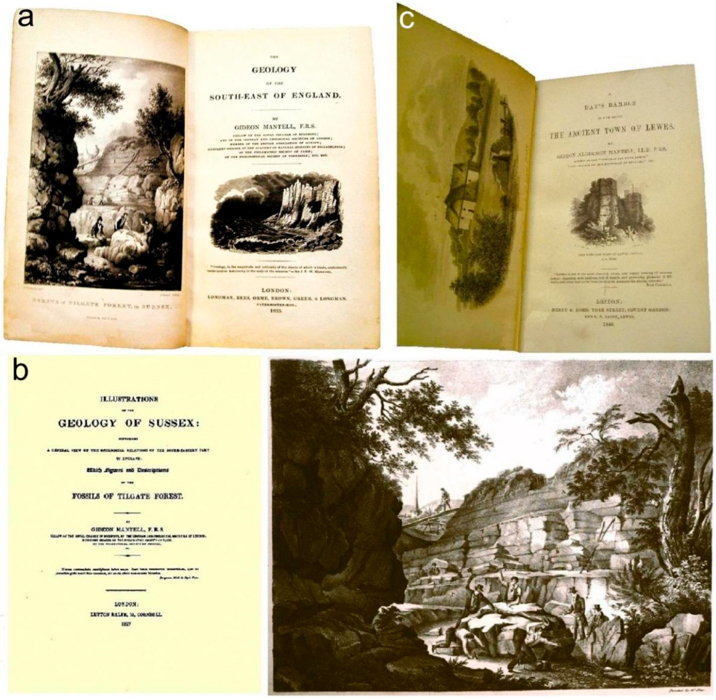
John Murray’s A Handbook for Travellers in Kent and Sussex (Murray, 1858) had a one-page topographically focussed Kent geology account, ‘Geology and Traveller’s View’; the un-illustrated guide promoted railways’ use for its excursions. One of the GA’s earliest excursions, to Kent’s Herne Bay and Reculver in 1863 (Dowker, 1863), noted a railway under construction. An 1884 excursion examined a railway cutting near Guildford, Surrey (Goodwin-Austin, 1884). Punch magazine for 19th September 1868 had an account of Broadstairs and Dover. However, the first attempts to summarise Kent’s (and Sussex’s) geology were Mantell’s The Fossils of the South Downs … (Mantell, 1822) and Geology of the South-East of England (Mantell, 1833) (Figure 11a); the latter was the first ever systematic regional geology account.

4.5.2. Some Sussex Geo-Texts

An early Sussex travelogue included the observation “That on the beach … are the fallen ruins of an old Tower … to show how much the sea has encroached in this County as well as in that of Kent” (Highmore, 1782, p. 33). Its first dedicated geology account was Mantell’s The Fossils of the South Downs … (Mantell, 1822); it was an expensive library volume with locality-specific information. Most of its 42 plates and substantial text were incorporated within his Illustrations of the geology of Sussex … (Mantell, 1827) (Figure 11b); this subscription volume was initially restricted to 150 copies, with a second c. 1829 printing (Cleevely & Chapman, 2000). Mantell’s truly pocketable Geology of the South-East of England (Mantell, 1833) has much Sussex information. His A Day’s Ramble in … Lewes (Mantell, 1846) (Figure 11c) has a geology chapter; its chalk-pit account exemplifies his self-promotion because“… from it I obtained the first fossil fish discovered in the chalk of the South Downs.” (Mantell, 1846, pp. 127–28). The posthumously published The Geology and Fossils … of Sussex (Dixon, 1850) was a worthy supplement involving several major illustrators and palaeontologists. Its second edition, almost 30 years later, reproduced Mantell’s Fossils of the South Downs … plates; its Preface suggested “… it formed a noble monument to a naturalist [Mantell] so prematurely lost …” (Dixon, 1878, p. 2). Murray’s A Handbook for Travellers in Kent and Sussex (Murray, 1858) had a seven-page Sussex topographical account. Some of the GA’s earliest excursions were to Lewes (Anonymous, 1862) and Hastings (Deck, 1862).

4.5.3. Some Isle of Wight Geo-Texts

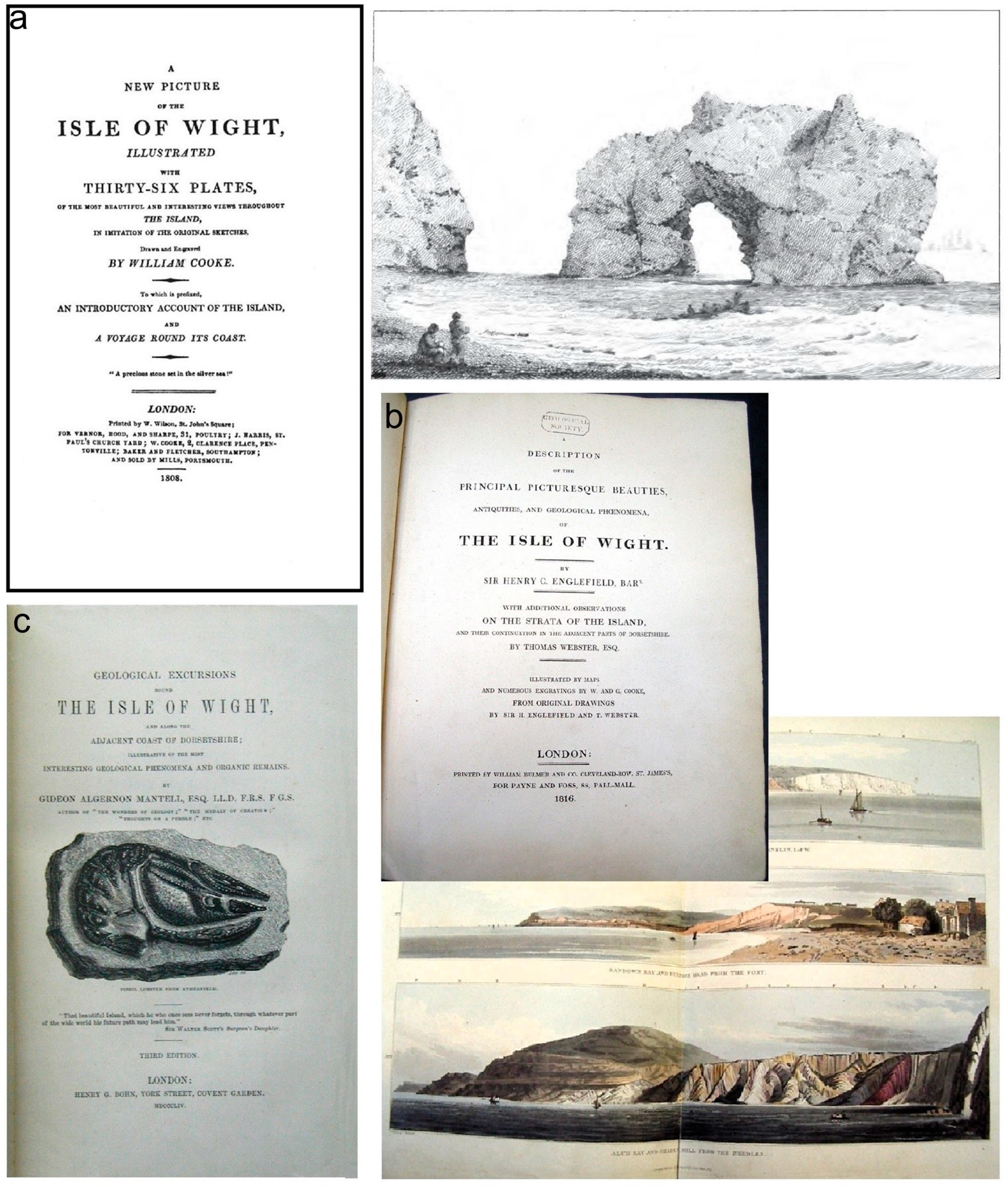
The Isle of Wight, as a popular resort island, had numerous 19th century geo-texts. An early geomorphological account is in A New Picture of the Isle of Wight (Cooke, 1808) (Figure 12a); the Blackgang landslip “… occasioned by the freezing of the spring in the chasms of the hill; the expansive force of the ice causing a separation at the base of the cliff …” (Cooke, 1808, p. 39). It included tourist itineraries and plates with descriptions of views of Freshwater Bay and the south coast chines; at Freshwater Bay “… the two detached and weather-beaten rocks that once formed part of the cliff … appear most picturesque and striking objects. In stormy weather …” (Cooke, 1808, p. 56). For the landscape aesthete, Blackgang Chine’s “… wild scenery that marks the rocky shore … well merits the notice of all lovers of the romantic and sublime.” (Cooke, 1808, p. 127).
Henry Charles Englefield’s (1752–1822) A Description … of the Isle of Wight (Englefield, 1816) (Figure 12b) was the region’s first detailed geology account. It was a substantial library volume, with detailed accounts of trees and woodlands; its 12 Thomas Webster (1772–1844) geology letters are noteworthy for his finely executed illustrations. Its Preface indicates its 1799–1801 research and much delayed publication forced him to request “… Webster, who was not unacquainted with natural history, and … an expert draftsman …” (Englefield, 1816, pp. i–iii) update his studies. Adam Sedgwick (1785–1873) authored an unillustrated major island geology paper (Sedgwick, 1822). The unillustrated A Topographical and Historical Guide (Sheridan, 1833) was prefaced “The various changes … requiring an accurate description of its merits, it has been deemed desirable that the accommodation and attractions … be carefully and correctly pointed out” (Sheridan, 1833, p. vii). It included botany and geology (acknowledged as based on publications by Sedgwick, Sowerby and Webster) notes, because the island “… presents numerous and peculiar advantages for observing its geological formation.” (Sheridan, 1833, p. 230).
Mantell’s Geological Excursions Round the Isle of Wight and along the Adjacent Coast of Dorsetshire (Mantell, 1847) was the first ever pocket-sized illustrated field-guide; its Preface noted the island’s geology was poorly known by even intelligent visitors to “… the picturesque localities … [who] take their departure without suspecting that they have been travelling over a country rich with the spoils of nature …” (Mantell, 1847, p. viii). It had some 20 plates, 45 illustrations and a geology map. The third edition’s (Mantell, 1854) (Figure 12c) Compton Chine account reveals Mantell’s local field knowledge and self-promotion; its cliff’s inclined strata are capped by a clay, gravel and loam layer containing “… numerous trunks of trees and quantities of hazel-nuts in the usual condition of peat or bog-wood… I picked up … teeth of the horse and deer …” (Mantell, 1854, p. 273).
Another attempt to fill the tourist niche-market, A Concise Exposition … of the Isle of Wight (Wilkins, 1861), was oddly a subscription volume; that is, not available over the counter for purchase. Its Preface admitted the authors consulted in its preparation lacked acknowledgement; the author’s personal observations had verified their work! Its descriptive text attempts to explain the importance of the Bembridge ‘oyster beds’ “… depends on the evident influx of salt water during their deposition, as marked by the abundance of oysters, accompanied by marine shells …” (Wilkins, 1861, p. 13). It was contemporaneous with the Geological Survey’s memoir (Bristow, 1862). The later A Popular Guide … (Norman, 1887) had 22 plates of fossils and topographic views, plus a map. Its seven chapters are essentially stratigraphic accounts; three appendices dealt with: authors’ revisions, Newport Museum and, the Ventnor Collection. Its Preface outlines its genesis, some 40 years after Mantell’s field-guide, in a series of Isle of Wight Advertiser newspaper letters. Whilst the author claimed his descriptions were “… in such a manner that the work may be useful to the geologist as well as entertaining to the general reader …” (Norman, 1887, pp. iii–iv) that aim was compromised by many lengthy Geological Survey publications’ quotes. He underscores specimen collecting’s significance, sometimes indicating that “… the fossil remains are of no great value for the cabinet …” (Norman, 1887, p. 149). The island attracted numerous publications because its coastal sections allowed geologists “… to examine the strata … in a manner which is impossible in inland districts, while the beauty of the scenery … lends an additional charm to the investigation.” (Harrison, 1882, p. 105). That and other 19th century geo-publications’ emphasis on aesthetic landscapes is adopted by many modern populist field-guides; likewise, the aim to meet leisure travellers’ needs.

4.6. The Historic Literature Analysed

The region’s guidebooks for the elite were rich in literary, antiquarian and artistic material; this was garnered from major antiquarian texts, such as Horsfield’s Sussex volumes (Horsfield, 1835). The early travel diaries and later tourist guidebooks were focussed on accommodation and travel information; they had resort and tourist attraction accounts. The travel arrangements within them reflected the evolving transport modes. This is particularly so for the elite, such as John Byng (Andrews, 1934), who shifted from horseback to post-chaise carriage (Anonymous, 1814), and then motor car (Murphy, 1908). For the middle classes and artists, railways became the transport mode (Bradshaw, 1861/2014; Green, 1989; Jordan & Jordan, 1991) and inspiration (Joyce, 1967).
The region’s geo-texts began with Mantell’s (1833) and finished with Davies’s (1914) volumes. The Isle of Wight had the most published populist geo-texts due to its well-exposed geosites. Its 19th century high excursionist and staying tourist numbers were greater than elsewhere in the region. They were preceded by, and were contemporaneous with, travel-guides. Their content reflected the changing markets and interests from the social elite to the middle classes. The interrelationships between the literature and artworks can be summarised (Figure 13).
Readability analysis of some of the geology field guides reveals their commonly technically descriptive and explanative nature. They exhibit high reading ages outside the ideal/acceptable range (Figure 14). This is somewhat at odds with their claims to meet general travellers’ needs—even after differences in contemporary (Gilliland, 1972) literary styles and literacy rates to the present-day are considered.

4.7. Some Proposed Geo-Interpretation

Some Current Provision

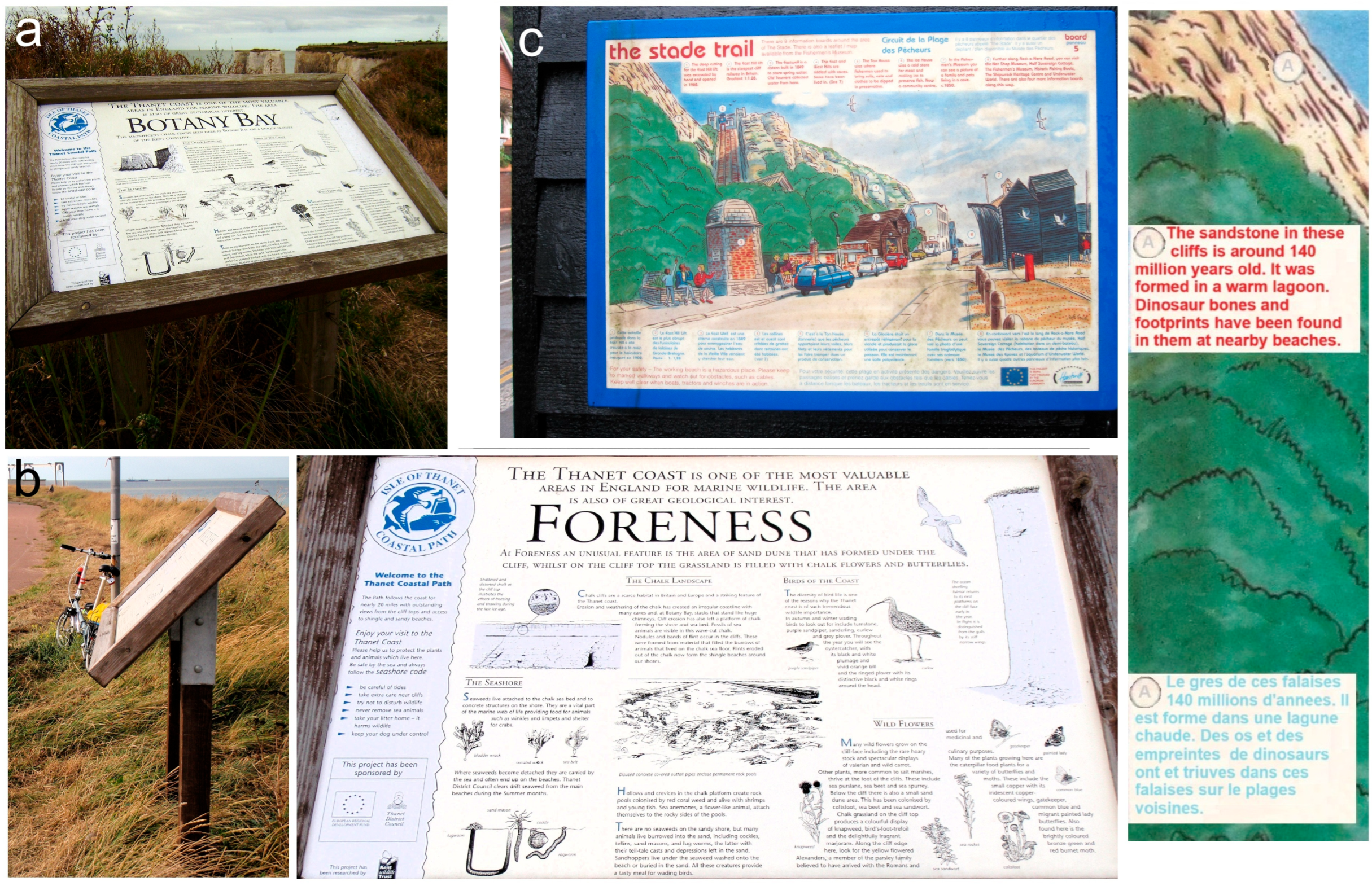
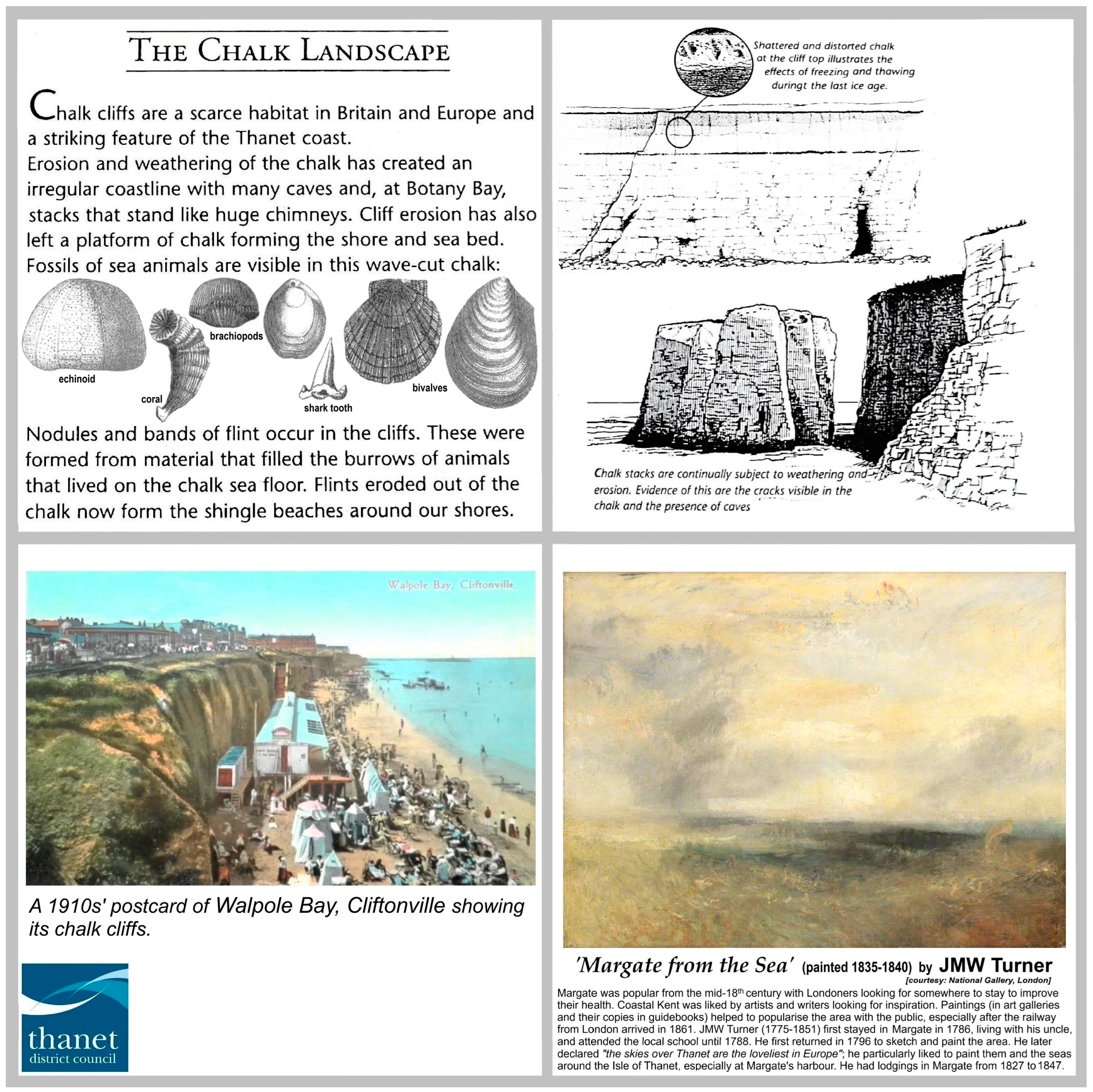
The region has a wealth of geosites, historic geo-literature, innumerable historic landscape paintings, plus well-illustrated reports with numerous historic images (e.g., Anonymous, 2013). Hence, it might be imagined that present-day geo-interpretation is widespread and includes some of their elements. However, its provision is sparse and local and natural history focussed; geology is barely mentioned. This can be seen in the present-day Margate and Hastings tourist interpretive panels (Figure 15). These at least follow long-held UK (Aldridge, 1993; Binks et al., 1988; Pierssene, 1999) and USA (Knudson et al., 1995; Tilden, 1977; Veverka, 1994) purported good interpretive practice in their inclusion of human interest, and mention of experiences and knowledge likely to be familiar to visitors; affirmed in recent geopark interpretive practice analysis (Štrba & Palgutová, 2024).
Margate’s geology is well seen at the Botany Bay and Foreness geosites. At each, wooden lecterns support A2-sized fibreglass-laminate interpretive panels (Figure 15a,b). They are natural-history focussed with some limited geology content. The latter was readily adaptable for the proposed geo-panel (Figure 16) that also this includes historic images and interpretive elements from this study; it could be used at both locations.
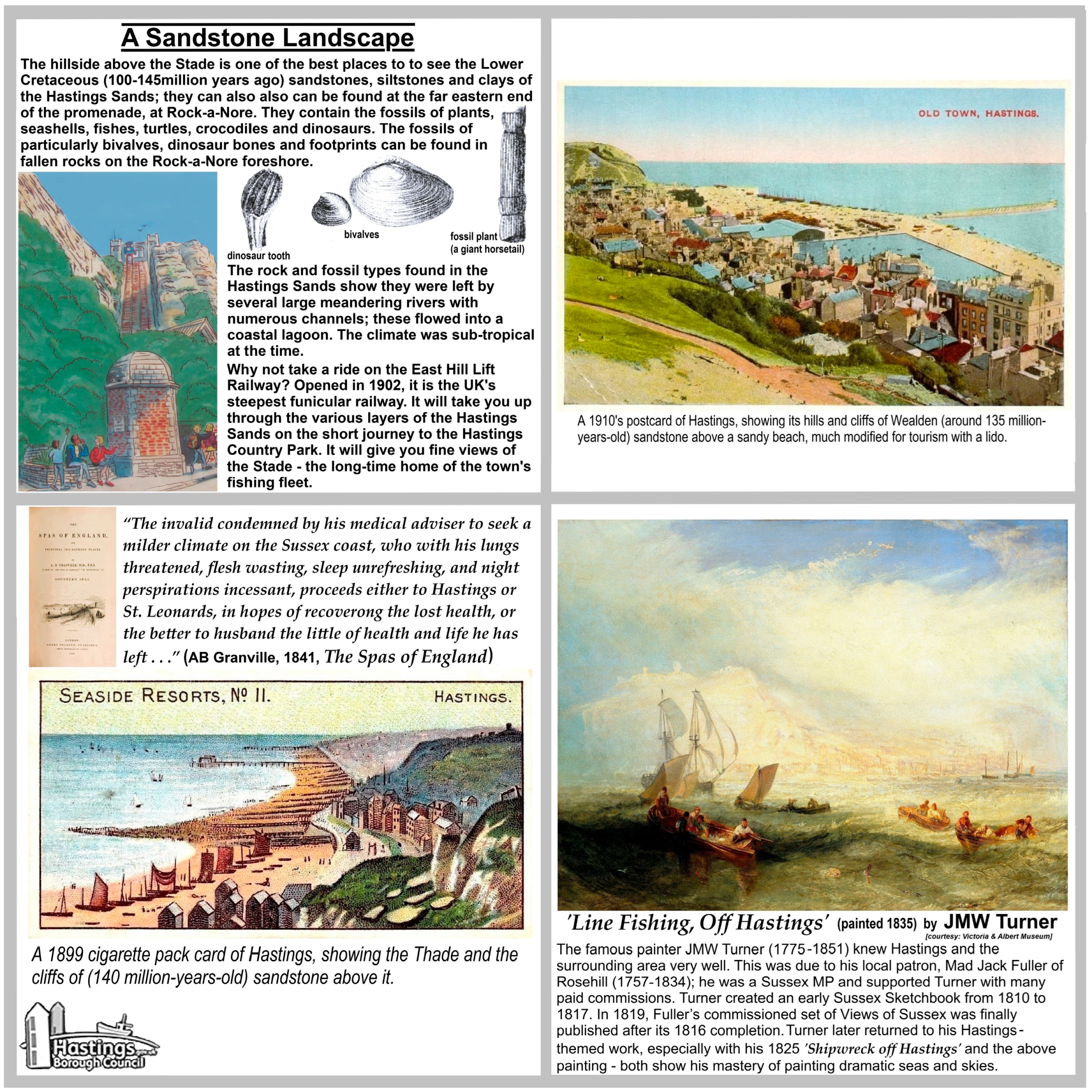
At Hastings an enamel A3-sized bilingual (English and French) panel, ‘the stade trail’, is focussed on the town’s fishing industry; it could be easily modified to accept the short geology note “The sandstone in these cliffs is around 140 million years old. It was formed in a warm lagoon. Dinosaur bones and footprints have been found in them at nearby beaches”; better still, a new geo-panel could be placed at the promenade’s eastern end. The proposed geo-panel includes historic images and their interpretation (Figure 17) based on elements from this study; quotes provide some human-interest local history.
Six-inch (15.24 cm) or larger square transfer-printed, white or cream ceramic tiles can be used to create discrete square (4 × 4 tiles) and rectangular (6 × 4 tiles) interpretive plaques; such have been employed in Spain’s Aliaga Geopark and proposed for elsewhere in England (Hose, 2017). These can be discretely affixed to existing structures and new brick-and-flint plinths to harmonise with their surroundings. They are a durable and virtually vandal-proof relatively low-cost product. When fitted with QR codes, they can readily become elements within geotrails; PDF guides to these can be provided as downloads (Hose, 2022), and likewise gpx files to aid route-finding. The same technologies can be used to offer more interactive interpretive experiences of landscape aesthetics and geomorphology (Whalley, 2022).

5. Closing Discussion

5.1. Some Remarks

Coastal Southern England’s geotourism development required a fundamental shift in the way landscapes were perceived and recorded. The influence of the Dutch (van den Ancker & Jungerius, 2016) and English Landscape Schools’ works on the recognition that ‘wild’ coastal places were safe, had an emerging beauty (Burke, 1757) and were worth visiting (Hose, 2008, pp. 42–43) was essential. Its original opening up to health tourists, then travellers (and what would now be geotourists) was much driven by the influence of landscape artists, antiquarian, travel and geological writers.

5.2. The ‘Travellers’ Gaze’

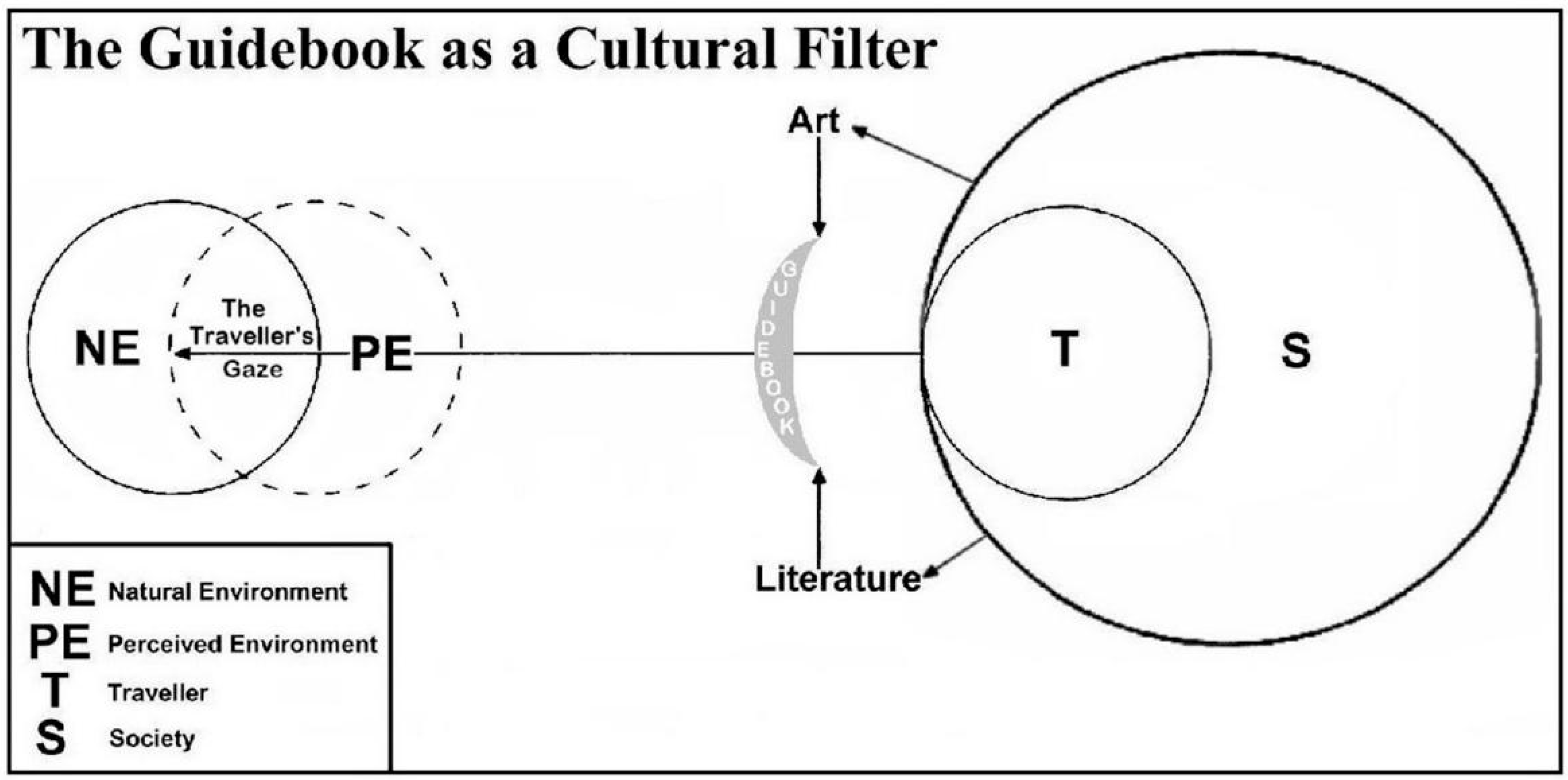
For some travellers landscapes are primarily natural features. For the less scientifically inclined they are purely cultural abstracts. However, they are, even if the travellers are unknowing, an admixture of the two (Hose, 2010, pp. 14–15); this can be modelled as the ‘Travellers’ Gaze’ (Figure 18). It underscores that landscapes are socio-cultural as much as natural physical constructs and that the ‘gaze’ has changed over time.
Consequently, each century’s travellers viewed the region from different mindsets and recorded them accordingly in their writings and art; there was an increasing acceptance of, and preference for, purportedly ‘wild’ (or ‘natural’) over tamed landscapes. Indeed, “To follow these journeys through three centuries is not only to watch the changing English landscape through the eyes of contemporaries, it is also to see the change in the vision itself as the interests and concerns of the tourists grow and develop from one generation to another.” (Daiches & Flower, 1979, p. xiii). However, Britons as members of the first urban society (from the 1841 census onwards), can be sentimental about their, particularly literary (Hardyment, 2000), landscapes. They like bucolic villages and ripe golden cornfields, epitomised by Constable’s paintings and Hardy’s writings. Equally, they appreciate the modernism of Turner’s interpretive paintings some of which, such as his 1844 Rain, Steam and Speed—The Great Western Railway’ and the 1834–1835 ‘The Burning of the Houses of Lords and Commons’, are iconically British.

5.3. The ‘Comfort Zone’

Those various influences and influencers facilitated different periods’ travellers’ acceptance of what was considered worth exploring and socially acceptable; these changing acceptances can be modelled on the shifting of their respective ‘comfort zone’ (Figure 19). The traveller’s comfort zone is a psychological, emotional, and behavioural construct defining their actions; it involves the interplay of familiarity, safety, and security factors. Travellers seek solace within their comfort zones, in which the familiar underpins a sense of security. For personal growth and new learning experiences they must breach these, possibly involving some anxiety and discomfort (as perhaps originally in sea-bathing!) for a perceived reward; discomfort is embraced as an acceptable travel companion.
The public’s early-18th century perceived risk of the regions’ dangerous ‘wild’ coastlands was overcome through perusal of the late-18th century guidebooks and artists’ changing representations and interpretations of landscapes; the role of historic ‘influencers’, such as the major landscape painters, cannot be underestimated. The predictability of travel and accommodation consequent upon the railways meant that excursionists felt secure in their arrangements; an elitist view (Moir, 1964, p. xiii) suggests by then they had lost travelling’s essence.

6. Conclusions

Reportage, curiosity, health recuperation, and then aesthetic worth preceded scientific study as travellers’ motivations. Literary descriptions and artistic representations, especially in guidebooks and travel-guides, led to untamed landscapes seeming less dangerous and remote. This led to the social acceptability of natural science fieldwork. Geology’s rise encouraged excursions and a rich geo-literature was subsequently published. From the 1860s, the GA’s excursion programme promoted geology fieldwork, particularly to the middle classes in the region. The surviving geosites of those established by the 19th century’s close are embedded in modern geotourism.
The outlined co-development of tourism and geotourism could probably be traced in Europe, providing a future country- or region-specific research topic; especially since there are relatively few published historiographic geotourism studies (e.g., Cayla et al., 2016; Migon, 2016; Reynard et al., 2011; Vasiljevic et al., 2016) for Europe. The historical aspects of geotourism’s development offer new geo-interpretive themes to engage with broad and novel (Hose, 2018, p. 767) audiences having little expressed interest in geology, with the past personalities and their experiences providing human interest content.
This review’s findings are aptly summarised by noting that: “The old English noun ‘travel’ used in the sense of a journey was originally the same thing as ‘travail’, and it implied trouble and discomfort. The hardships endured by the tourists of Britain … the purpose … was pleasure. This was travel for its own sake …” (Moir, 1964, p. xiii). Over some 350 years, Coastal Southern England witnessed coastal tourism’s, and latterly geotourism’s, enfranchisement for social classes beyond the initial elite.

Funding

This research received no external funding.

Institutional Review Board Statement

Not applicable.

Informed Consent Statement

Not applicable.

Data Availability Statement

No new data were created or analyzed in this study.

Acknowledgments

The author gratefully acknowledges the library and research facilities afforded him by, and the encouragement of Mike Benton of, the School of Earth Sciences, University of Bristol, UK. Likewise, access to the Geological Society of London’s reserve collection is gratefully acknowledged. He would especially like to thank two of the reviewers of the paper’s first draft—one who provided very detailed constructive, and the other supportive, comments; that encouragement saw the paper through to its much improved final form.

Conflicts of Interest

The author declares no conflicts of interest.

References

  1. Aldridge, D. (1993). Site interpretation: A practical guide. Scottish Tourist Board. [Google Scholar]
  2. Allen, D. E. (1986). The botanists: A history of the botanical society of the British Isles through a hundred and fifty years. St Paul’s Bibliographies. [Google Scholar]
  3. Allen, D. E. (1994). The naturalist in Britain: A social history (2nd ed.). Princeton University Press. [Google Scholar]
  4. Andrews, C. B. (Ed.). (1934). The Torrington diaries: Containng the tours through England and Wales of the Hon. John Byng (Later fifth viscount of Torrington) between the years 1781 and 1794 (Vol. 1). Eyre & Spottiswoode. [Google Scholar]
  5. Anonymous. (1814). The Cambrian tourist, or post-chaise companion through Wales; Being a short but comprehensive description of every object most worthy of attention in the Welch territories with a chart, showing at one view the most eligible route, best inns, distances, and objects (5th ed.). Walker, Edwards, and Reynolds. [Google Scholar]
  6. Anonymous. (1832). The Gentlemans magazine and historical chronicle (Vol. 52, p. 45). [Google Scholar]
  7. Anonymous. (1859). Nelson’s hand-book for tourists: The Isle of Wight, with a description of the geology of the island. Nelson. [Google Scholar]
  8. Anonymous. (1860). Excursion to Folkestone, April 9th, 1860. Proceedings of the Geologists’ Association, 1, 47. [Google Scholar]
  9. Anonymous. (1862). Excursion to Lewes, August 6th, 1862. Proceedings of the Geologists’ Association, 1(8), 274–277. [Google Scholar]
  10. Anonymous. (2013). Case study 3C—Hastings, UK. In Arch-Manche: Archaeology, art and coastal heritage—Tools to support the coastal management and climate change planning across the Channel Regional Sea: Technical report. Arch-Manche. [Google Scholar]
  11. Aslet, C. (2005). Landmarks of Britain: The five hundred places that made our history. Hodder & Stoughton. [Google Scholar]
  12. Awsiter, J. (1768). Thoughts on Brightelmston. Concerning sea-bathing, and drinking sea-water. With some directions for their use in a letter to a friend. J. Wilkie. [Google Scholar]
  13. Barton, H. A. (1998). Northern Arcadia: Foreign travelers in Scandinavia, 1765–1815. Southern Illinois University Press. [Google Scholar]
  14. Binks, G., Dyke, J., & Dagnall, P. (1988). Visitors welcome: A manual on the presentation and in terpretation of archaeological excavations. HMSO. [Google Scholar]
  15. Black, J. (1993). Italy and the grand tour. Yale University Press. [Google Scholar]
  16. Black, J. (2003). The British abroad: The grand tour in the eighteenth century (2nd ed.). History Press. [Google Scholar]
  17. Bradshaw, G. (2014). Bradshaw’s descriptive railway hand-book of Great Britain and Ireland. W.J. Adams [2014 reprint. Glasgow: Harper Collins]. (Original work published 1861). [Google Scholar]
  18. Briggs, A. (1983). A social history of England. Wiedenfeld & Nicholson. [Google Scholar]
  19. Bristow, H. W. (1862). The geology of the Isle of Wight. Geological Survey of England & Wales. [Google Scholar]
  20. Burek, C. V., & Hose, T. A. (2016). The role of local societies in early modern geotourism: A case study of the Chester Society of Natural Science and the Woolhope Naturalists’ field club. In T. A. Hose (Ed.), Appreciating physical landscapes: Three hundred years of geotourism—Special publications, 417 (pp. 95–116). The Geological Society of London. [Google Scholar]
  21. Burke, E. (1757). A philosophical enquiry into the origin of our ideas of the sublime and beautiful. R. and J. Dodsley. [Google Scholar]
  22. Cabanal, D. (1814). Poems and imitations. Stratford. [Google Scholar]
  23. Cayla, N., Gauchon, C., & Hoblea, F. (2016). From tourism to geotourism: A few historical cases from the French Alpine Foreeland. In T. A. Hose (Ed.), Appreciating physical landscapes: Three hundred years of geotourism—Special publications, 417 (pp. 199–213). The Geological Society of London. [Google Scholar]
  24. Cleevely, R. J., & Chapman, S. D. (2000). The two states of Mantell’s Illustrations of the geology of Sussex …; 1827 and c. 1829. Archives of Natural History, 21(1), 23–50. [Google Scholar] [CrossRef]
  25. Cobbett, W. (1957). Rural rides (2 volumes). J.M. Dent. [Google Scholar]
  26. Cole, S., Breuer, K., Palmer, S. W., & Blakeslee, B. (2022). How history is made: A student’s guide to reading, writing, and thinking in the discipline. Mavs Open Press. [Google Scholar]
  27. Conybeare, W. D., & Phillips, W. (1822). Outlines of the geology of England and Wales. William Phillips. [Google Scholar]
  28. Cooke, W. B. C. (1808). A new picture of the Isle of Wight, illustrated with thirty-six plates, of the most beautiful and interesting views throughout the island, in imitation of the original sketches, drawn and engraved by William Cooke, to which is prefixed an introductory account of the island, and a voyage around its coast. Vernon, Hood, and Sharpe. [Google Scholar]
  29. Daiches, D., & Flower, J. (1979). Literary landscapes of the British Isles: A narrative atlas. Paddington Press. [Google Scholar]
  30. Davies, G. M. (1914). Geological excursions round London. Thomas Murby & Co. [Google Scholar]
  31. Dean, D. R. (1985). Tennyson and geology. Tennyson Research Centre. [Google Scholar]
  32. Dean, D. R. (1999). Gideon Mantell and the discovery of dinosaurs. Cambridge University Press. [Google Scholar]
  33. Deck, A. (1862). Excursion to Hastings. Proceedings of the Geologists’ Association, 1(2), 248. [Google Scholar] [CrossRef]
  34. Defoe, D. (n.d.). A tour through England and Wales. J.M. Dent. [Google Scholar]
  35. De la Beche, H. T. (1831). A geological manual. Truetel & Wurtz. [Google Scholar]
  36. De la Beche, H. T. (1835). How to observe. Charles Knight. [Google Scholar]
  37. De la Beche, H. T. (1851). The geological observer. Longman, Brown, Green & Longman. [Google Scholar]
  38. Dixon, F. (1850). The geology and fossils of the Cretaceous and Tertiary formations of Sussex. Longman, Brown, Green & Longman. [Google Scholar]
  39. Dixon, F. (1878). The geology of Sussex or the geology and fossils of the Cretaceous and Tertiary formations of Sussex (T. R. Jones, Ed.; 2nd ed.). William J. Smith. [Google Scholar]
  40. Dowker, G. (1863). Excursion to Herne Bay and Reculver, June 26th, 1863. Proceedings of the Geologists’ Association, 1(10), 339–345. [Google Scholar]
  41. Duszyński, F., & Migoń, P. (2020). Sandstone landforms of the high weald. In A. Goudie, & P. Migoń (Eds.), Landscapes and landforms of England and Wales (pp. 103–118). Springer. [Google Scholar]
  42. Englefield, H. C. (1816). A description of the principal picturesque beauties, antiquities and geological phenomena of the Isle of Wight. With additional observations on the strata of the Island, and their continuation in the adjacent parts of Dorsetshire by Thomas Webster. Payne & Foss. [Google Scholar]
  43. Flanders, J. (2006). Consuming passions: Leisure and pleasure in Victorian Britain. Hodder & Stoughton. [Google Scholar]
  44. Folkestone and Hythe Borough Council. (n.d.). Available online: https://www.folkestoneandhythe.co.uk/stories/geosites-newbie-or-in-the-know/ (accessed on 28 May 2025).
  45. Freeman, E. F. (1992). The origins of the geologists’ assocation. Archives of Natural History, 19(1), 1–27. [Google Scholar] [CrossRef]
  46. Gilliland, J. (1972). Readability. University of London Press. [Google Scholar]
  47. Goodwin-Austin, H. H. (1884). Excursion to Guildford and the new railway works in progress there. Saturday, April 26th, 1884. Proceedings of the Geologists’ Association, 8(7), 390–391. [Google Scholar]
  48. Gordon, S. (1972). Past-into-present series: Holidays. B.T. Batsford Ltd. [Google Scholar]
  49. Granville, A. B. (1841). The spas of England and principal sea-bathing places: Southern places (2 volumes). Henry Colbourn. [Google Scholar]
  50. Gray, F. (2006). Designing the seaside. Reaktion Books Ltd. [Google Scholar]
  51. Green, C. P. (1989). Excursions in the past: A review of the Field Meeting Reports in the first one hundred volumes of the proceedings. Proceedings of the Geologists’ Association, 100(1), 17–29. [Google Scholar] [CrossRef]
  52. Hardyment, C. (2000). Literary trails: Writers in their landscapes. National Trust Enterprises. [Google Scholar]
  53. Harrison, W. J. (1882). Geology of the counties of England and of North and South Wales. Kelly & Co./Simpkin, Marshall & Co. [Google Scholar]
  54. Henriques, M. H., & Brilha, J. (2017). UNESCO Global Geoparks: A strategy towards global understanding and sustainability. Episodes, 40(4), 349–355. [Google Scholar] [CrossRef]
  55. Hibbs, J. (1989). The history of British buse services (2nd ed.). David & Charles. [Google Scholar]
  56. Higgins, W. M. (1842). The book of geology being an elementary treatise on that science to which is appended an account of the geology of English watering-places. R. Tyas. [Google Scholar]
  57. Highmore, A. (1782). A ramble on the coast of Sussex more than 100 years ago (Hindley, C. (ed.) 1873). Reeves & Turner. [Google Scholar]
  58. Hill, D. (1985). Constable’s English landscape scenery. John Murray. [Google Scholar]
  59. Holmes, T. V., & Sherborn, C. D. (1891). Geologists’ association: A record of excursions made between 1860 and 1890. Stanford. [Google Scholar]
  60. Horsfield, T. W. (1835). The history and antiquities and topography of the county of Sussex (2 volumes). Sussex Books. [Google Scholar]
  61. Hose, T. A. (1995). Selling the story of Britain’s stone. Environmental Interpretation, 10(2), 16–17. [Google Scholar]
  62. Hose, T. A. (2008). Towards a history of geotourism: Definitions, antecedents and the future. In C. V. Burek, & C. D. Prosser (Eds.), The History of geoconservation. Geological society, special publications, 300 (pp. 37–60). The Geological Society of London. [Google Scholar]
  63. Hose, T. A. (2010). The significance of aesthetic landscape appreciation to modern geotourism provision. In D. Newsome, & R. K. Dowling (Eds.), Geotourism: The tourism of geology and landscape (pp. 13–26). Goodfellow. [Google Scholar]
  64. Hose, T. A. (2012). 3Gs for modern geotourism. Geoheritage, 4(1–2), 7–24. [Google Scholar] [CrossRef]
  65. Hose, T. A. (2016). Three centuries (1670–1970) of appreciating physical landscapes. In T. A. Hose (Ed.), Appreciating physical landscapes: Three hundred years of geotourism—Special publications, 417 (pp. 1–22). The Geological Society of London. [Google Scholar]
  66. Hose, T. A. (2017). The English Peak District (as a potential geopark): Mining geoheritage and historical geotourism. Acta Geoturistica, 8(2), 32–49. [Google Scholar] [CrossRef]
  67. Hose, T. A. (2018). Awheel in Edwardian Bedfordshire: A 1905 geologists’ association cycling excursion revisited and contextualised. Proceedings of the Geologists’ Association, 129(6), 748–769. [Google Scholar] [CrossRef]
  68. Hose, T. A. (2021). Historical viewpoints on the geotourism concept in the 21st century. In B. N. Sadry (Ed.), The geotourism industry in the 21st century (pp. 23–92). Apple Academic Press. [Google Scholar]
  69. Hose, T. A. (2022). Recycling edwardian geology excursions for five modern cyclists’ geotrails in England. Geoconservation Research, 5(1), 209–239. [Google Scholar]
  70. Jordan, A., & Jordan, E. (1991). Away for the day; The railway excursion in Britain. 1830 to the present day. Silver Link Publishing Ltd. [Google Scholar]
  71. Joyce, J. (1967). The story of passenger transport in Britain. Ian Allan. [Google Scholar]
  72. Kent Downs National Landscape. (n.d.). Available online: https://kentdowns.org.uk/geopark/ (accessed on 28 May 2025).
  73. Knudson, D. M., Cable, T. T., & Bec k, L. (1995). Interpretation of cultural and natural resources. Venture Publishing. [Google Scholar]
  74. Leed, E. J. (1991). The mind of the traveler: From Gilgamesh to global tourism. Basic Books. [Google Scholar]
  75. Lyell, C. (1830–1833). Principles of geology: Being an attempt to explain the former changes of by the earth’s surface, reference to causes now in operation (3 volumes). John Murray. [Google Scholar]
  76. Mabey, R. (1986). Gilbert White: A biography of the author of the natural history of selbourne. Century Hutchinson. [Google Scholar]
  77. Mahomed, S. D. (1826). Shampooing; or, benefits resulting from the use of the Indian medicated vapour bath as introducedinto this country by S. D. Mahomed. Creasy & Baker. [Google Scholar]
  78. Mantell, G. A. (1822). The fossils of the south downs; or illustrations of the geology of Sussex. Lupton Relfe. [Google Scholar]
  79. Mantell, G. A. (1827). Illustrations of the geology of Sussex containing a general view of the geological relations of the south-eastern part of England: With figures and descriptions of the fossils of Tilgate forest. Lupton Relfe. [Google Scholar]
  80. Mantell, G. A. (1833). The geology of the south-east of England. Longman, Rees, Orme. [Google Scholar]
  81. Mantell, G. A. (1844). Medals of creation; or, first lessons in geology, and in the study of organic remains (2 vols.). Henry G. Bohn. [Google Scholar]
  82. Mantell, G. A. (1846). A day’s ramble in and around the ancient town of Lewes. Henry Bohn. [Google Scholar]
  83. Mantell, G. A. (1847). Geological excursion round the Isle of Wight and along the adjacent coast of Dorsetshire: Illustrative of the most interesting geological phenomena and organic remains. Henry G. Bohn. [Google Scholar]
  84. Mantell, G. A. (1854). Geological excursion round the Isle of Wight and along the adjacent coast of Dorsetshire: Illustrative of the most interesting geological phenomena and organic remains (3rd ed.). Henry G. Bohn. [Google Scholar]
  85. Measom, G. M. (1853). The official illustrated guide to the Brighton and south coast railways and all their branches, including a description of the crystal palace at Sydenham, and a topographical account of the Isle of Wight. H.G. Collins. [Google Scholar]
  86. Measom, G. M. (1858). The official illustrated guide to the south-eastern railway and its branches, including the north Kent and greenwhich lines. H.G. Collins. [Google Scholar]
  87. Migon, P. (2016). Rediscovering geoheritage, reinventing geotourism: 200 years of experience from the Sudetes, Central Europe. In T. A. Hose (Ed.), Appreciating physical landscapes: Three hundred years of geotourism—Special publications, 417 (pp. 215–228). The Geological Society of London. [Google Scholar]
  88. Moir, E. (1964). The discovery of Britain: The English tourists 1540–1840. Routledge & Keagan Paul. [Google Scholar]
  89. Monckton, H. W., & Herries, R. S. (Eds.). (1909). Geology in the field: The jubilee volume of the geologists’ association, 1858–1908. Stanford. [Google Scholar]
  90. Morley, F. (1983). Literary Britain: A reader’s guide to its writers and its landmarks. Dorset Press. [Google Scholar]
  91. Morris, C. (Ed.). (1949). The journeys of Celia Fiennes. Cresset. [Google Scholar]
  92. Murphy, T. D. (1908). British highways and byways from a motor car: Being a record of a five thousand mile tour in Englnad, Wales and Scotland. L.E. Page & Co. [Google Scholar]
  93. Murray, J. (1858). A handbook for travellers in Kent and Sussex. John Murray. [Google Scholar]
  94. Norman, M. W. (1887). A popular guide to the geology of the Isle of Wight, with a note on its relation to that of the Isle of Purbeck. Knight’s Library. [Google Scholar]
  95. Parris, L., Flemming-Williams, I., & Shields, C. (1976). Constable paintings, watercolours & drawings. The Tate Gallery. [Google Scholar]
  96. Phillips, W. (1818). A selection of facts from the best authorities, arranged so as to form an outline of the geology of England and Wales. William Phillips. [Google Scholar]
  97. Pierssene, A. (1999). Explaining our world: An approach to the art of environmental interpretation. Spon. [Google Scholar]
  98. Reynard, E., Hoblea, F., Cayla, N., & Gauchon, C. (2011). Iconic sites for alpine geology and geomorphology rediscovering heritage? Revue de Ge’o graphie Alpine: New Heritage: Objects, Actors and Controversy Nouveaux Patrimoines, 99(2), 1–11. [Google Scholar]
  99. Robinson, D. K. (1984). The landscape of Thomas Hardy. Webb & Bower. [Google Scholar]
  100. Russell, R. (1752). A dissertation on the use of sea-water in the diseases of the glands. Particularly the scurvy, jaundice, King’s-evil, leprosy, and the glandular consumption, translated from the Latin of Richard Russel, M.D. by an Eminent Phyfian. W. Owen/R. Goadby. [Google Scholar]
  101. Sadry, B. N. (2021). The scope and nature of geotourism in the 21st century. In B. N. Sadry (Ed.), The geotourism industry in the 21st century (pp. 3–21). Apple Academic Press. [Google Scholar]
  102. Sager, F., & Rosser, C. (2015). Historical Methods. In M. Bevir, & R. A. W. Rhodes (Eds.), The routledge handbook of interpretive political science (pp. 199–210). Routledge. [Google Scholar]
  103. Sedgwick. (1822). Article III: On the geology of the Isle of Wight. The Annals of Philosophy, New Series, 3(III), 328–356. [Google Scholar]
  104. Shanes, E. (1981). Turner’s rivers, harbours and coasts. Chatton & Windus. [Google Scholar]
  105. Shanes, E. (1990). Turner’s England 1810–1838. Cassell. [Google Scholar]
  106. Sheridan, W. C. F. G. (1833). A topographical and historical guide to Isle of Wight. T. Brettell. [Google Scholar]
  107. Shiflett, O. L. (1984). Clio’s claim: The role of historical research in library and information science. Library Trends, 32(4), 385–406. [Google Scholar]
  108. Sillitoe, A. (1995). Leading the blind: A century of guidebook travel 1815–1911. Macmillan. [Google Scholar]
  109. Stainton, L. (1985). British landscape watercolours 1600–1860. British Museum Publications. [Google Scholar]
  110. Štrba, L., & Palgutová, S. (2024). Geoheritage interpretation panels in UNESCO global geoparks: Recommendations and Assessment. Geoheritage, 16(96), 1–25. [Google Scholar] [CrossRef]
  111. Sweet, R. (2001). Antiquaries and antiquities in eighteenth-century England. Eighteenth-Century Studies, 34(2), 181–206. [Google Scholar] [CrossRef]
  112. Thorndyke, A. H. (1920). Literature in a changing age. Macmillan. [Google Scholar]
  113. Tilden, F. (1977). Interpreting our heritage (3rd ed.). University of North Carolina Press. [Google Scholar]
  114. Turnock, D. (1998). An historical geography of railways in Great Britain and Ireleand. Ashgate. [Google Scholar]
  115. UNESCO. (2000). UNESCO geoparks programme feasibility study, August 2000. UNESCO. [Google Scholar]
  116. van den Ancker, J. A. M. H., & Jungerius, P. D. (2016). Landscape and geotourism on the Dutch coast in the seventeenth century as depicted by landscape artists. In T. A. Hose (Ed.), Appreciating physical landscapes: Three hundred years of geotourism—Special publications, 417 (pp. 71–82). The Geological Society of London. [Google Scholar]
  117. Vasiljevic, D. A., Markovic, S. B., & Vujicic, M. D. (2016). Appreciating loess landscapes through history: The basis of modern loess geotourism in the Vojvodina region of North Serbia. In T. A. Hose (Ed.), Appreciating physical landscapes: Three hundred years of geotourism—Special publications, 417 (pp. 229–239). The Geological Society of London. [Google Scholar]
  118. Vaughan, W. (1999). Arcadia. In W. Vaughan (Ed.), British painting: The golden age (pp. 205–237). Thames & Hudson. [Google Scholar]
  119. Veverka, J. A. (1994). Interpretive master planning. Falcon. [Google Scholar]
  120. Walford, T. (1818). The scientific tourist through England, Wales, & Scotland by which the traveller is directed to the principal objects of antiquity, art, science, and the Picturesque, including the minerals, fossils, rare plants, and other subjects of natural history arranged by counties to which is added an introduction to the study of antiquities, and the elements of statistics, geology, mineralogy, and botany (Vol. 1). J. Booth. [Google Scholar]
  121. Waller, P. J. (1983). Town, city, and nation: England 1850–1914. Oxford University Press. [Google Scholar]
  122. Whalley, B. W. (2022). Earth science, art and coastal engineering at the seaside: Envisioning an open exploratorium or geo-promenade at Weston-super-Mare, Somerset, United Kingdom. Geoheritage, 14(113), 1–19. [Google Scholar] [CrossRef]
  123. Wilkins, E. P. (1861). A concise exposition of the geology, antiquities, and topography of the Isle of Wight. T. Kentfield. [Google Scholar]
  124. Woodward, H. B. (1907). The history of the geological society of London. The Geological Society of London. [Google Scholar]
  125. Wyatt, J. (1995). Wordsworth and the geologists. Cambridge University Press. [Google Scholar]
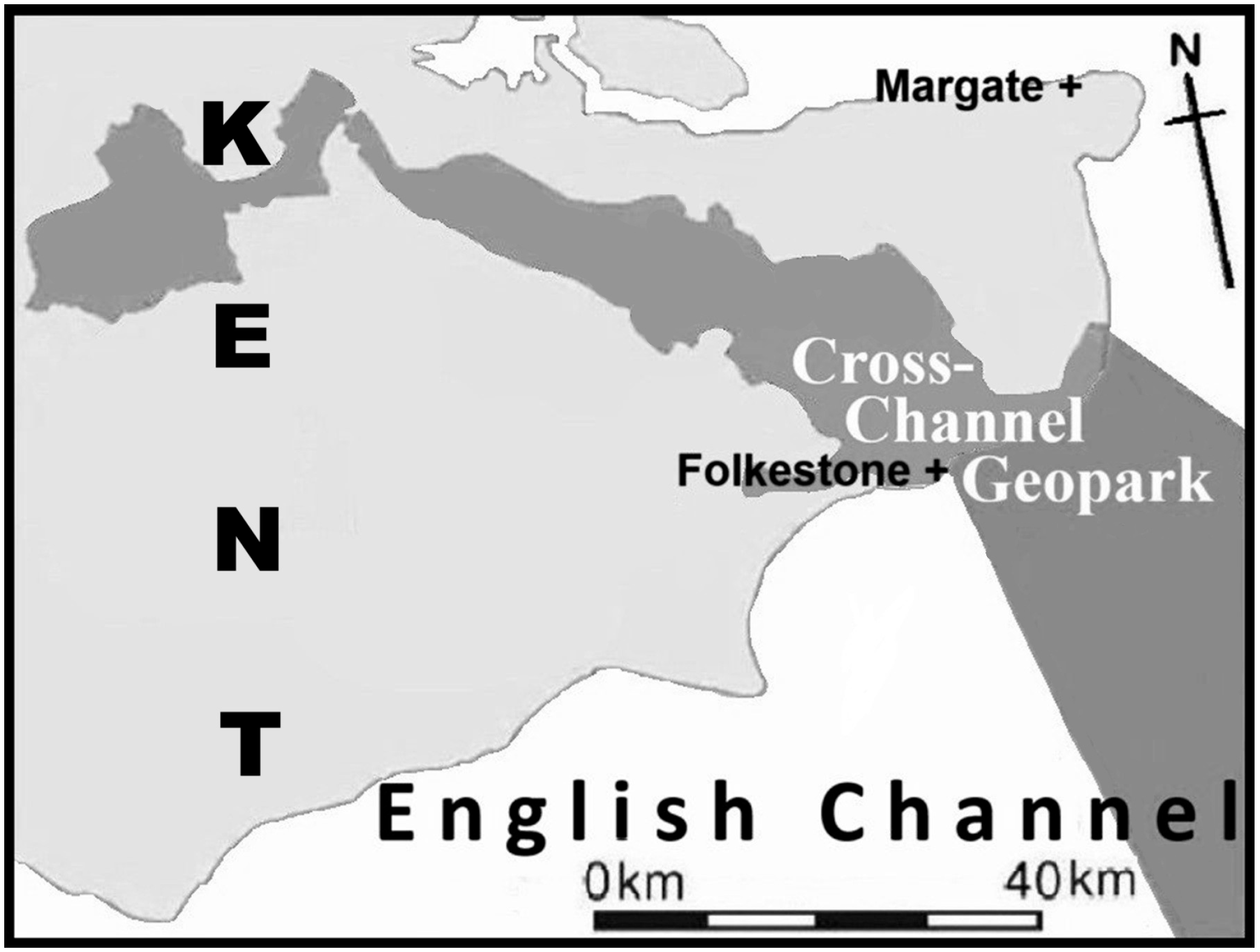
Figure 1. The counties of ‘Coastal Southern England’.
Tourismhosp 06 00155 g001
Figure 2. Map showing the location, in Kent and offshore, of the Cross-Channel Geopark; note that the Folkstone and Margate are towns and denoted by a cross.
Tourismhosp 06 00155 g002
Figure 3. Geological map of ‘Coastal Southern England’.
Tourismhosp 06 00155 g003
Figure 4. Some textbook geosites illustrated in 1910s’ postcards: (a) Walpole Bay, Margate—chalk cliffs and sandy bay; (b) ’Toad Rock’, Tunbridge Wells—a classic hoodoo (mushroom) rock in Wealden sandstone; (c) ‘The Needles’—chalk cliffs and sea stacks; (d) Hastings—Wealden sandstone hills and coastal cliffs above a sandy beach (much modified for tourism with a lido).
Tourismhosp 06 00155 g004
Figure 5. The Region’s Road and Railways: (a) Turnpike and major roads opened by 1750; (b) Road journey times at the turn of the 18th century; (c) The railway network, showing some of the major coastal towns served by it, in the 1870s; (d) A railway viaduct near Brighton seen in John Wilson Carmichael’s 1848 painting (monochrome detail h).
Tourismhosp 06 00155 g005
Figure 6. Seawater cures: (a) John Aswiter’s 1769 Brighton indoor baths; (b) Dean Mahomed’s 1821 baths, as seen in 1826; (c) Margate’s 1796 Sea Bathing Hospital, as seen in 1831; (d) Herne Bay’s 1831 Royal Pier, as seen in 1850; (e) Russell’s 1752 A Dissertation on the Use of Sea Water in the Diseases of the Glands, title-page.
Tourismhosp 06 00155 g006
Figure 7. Some artistic representations: (a) John Contsable’s 1824 Hove Beach’ (monochrome detail); (b) JMW Turner’s c.1845 Margate Harbour’ (monochrome detail from); (c) Powell Frith’s Ramsgate Sands’, exhibited at the Royal Academy in 1856 (monochrome detail); (d) Charles Dyce’s Pegwell Bay, Kent—a Recollection of October 5th, 1858’ (monochrome detail).
Tourismhosp 06 00155 g007
Figure 8. Some travel guides: (a) Adam & Charles Black’s 1886 Guide to the County of Sussex and its Watering Places, title-page (top left) and ‘Brighton Pier’ illustration (top centre); (b) Ward Lock’s 1880 A Pictorial and Descriptive Guide to the Isle of Wight, with its distinctive binding (top right) and typical plate (bottom right); (c) Macmillan’s 1908 British Highways and Byways from a Motor Car, title-page (bottom left) and plate (bottom centre); this is the USA edition, hence the ‘British’ prefix to its title.
Tourismhosp 06 00155 g008
Figure 9. Three geology textbooks: (a) The Book Of Geology … (Higgins, 1842), title-page (top left) and hand-coloured Headon Hill, Isle of Wight geological cross-section (bottom left); (b) Outlines of the Geology of England and Wales (Conybeare & Phillips, 1822), title-page and fold-out hand-coloured geological map; (c) The Scientific Tourist … (Walford, 1818), Dover Castle frontispiece (top centre) and title-page (top right).
Tourismhosp 06 00155 g009
Figure 10. Geology manuals and the textbook: (a) A Geological Manual (De la Beche, 1831), title-page; (b) How to Observe (De la Beche, 1835), title-page (top centre) and p. 7 illustrations of sea cliffs (top right); (c) The Geological Observer (De la Beche, 1837), title-page (bottom left) and p.77 illustrations of ‘Action of Sea on Coasts’ (bottom left centre); (d) Principles of Geology, Volume 3 (5th ed.) (Lyell, 1837), title-page (bottom centre right) and p. 372 illustrations of fossil marine shells (bottom right).
Tourismhosp 06 00155 g010
Figure 11. Hampshire, Kent and Sussex Geo-Texts: (a) A Day’s Ramble in and around the Ancient Town of Lewes (Mantell, 1846), frontispiece and title-page; (b) Geology of the South-East of England (Mantell, 1833), frontispiece and title-page; (c) Illustrations of the Geology of Sussex (Mantell, 1827), title-page and (rotated) frontispiece, illustrating the world’s first dinosaur fossil find-spot at Tilgate Forest.
Tourismhosp 06 00155 g011
Figure 12. Isle of Wight Geo-Texts: (a) A New Picture of the Isle of Wight (Cooke, 1808), title-page and plate of a sea-arch at Freshwater Bay; (b) A Description … of the Isle of Wight (Englefield, 1816), title-page and plate of three coast views; (c) Geological Excursion Round the Isle of Wight … (Mantell, 1854), 3rd ed., title-page.
Tourismhosp 06 00155 g012
Figure 13. A timeline summarising Coastal Southern England’s travellers, publications, artworks and tourism developments contextualised by the Grand Tour and later artistic movements.
Tourismhosp 06 00155 g013
Figure 14. Some Geo-publications’ readability: Note that they lie outside the acceptable range for their modern equivalents; note that each star marks the exact placement of each named text within the chart.
Tourismhosp 06 00155 g014
Figure 15. Present-day Interpretive Panels: (a) At Botany Bay near the cliff edge; (b) At Foreness Point, showing the roadside lectern panel; (c) The Stade, Hastings panel, affixed to a wooden hut, and its proposed new geology label (for the left hand side) in close up.
Tourismhosp 06 00155 g015
Figure 16. Proposed Margate Geo-Plaque: The ‘Chalk Landscape’ tile incorporates some of the illustrations and texts, from both the Botany Bay and Foreness interpretive panels, modified for a generic panel. The fossil illustrations are from a 19th century textbook. The Turner painting’s text explains his long association with Margate and that it shows the chalk cliffs in the background.
Tourismhosp 06 00155 g016
Figure 17. Proposed Hastings Geo-Plaque: The ‘A Sandstone Landscape’ section has some current ‘The Thede’ interpretive panel material and fossil illustrations from a 19th century textbook. The postcard and cigarette card illustrations show turn of the 20th century tourist facilities. The Turner painting’s (with the sandstone cliffs in the background) text describes his local associations. The ‘Spas of England’ (Granville, 1841) title-page has an apposite quote (Granville, 1841, p. 584).
Tourismhosp 06 00155 g017
Figure 18. The ‘Travellers’ Gaze’ model: in this the guidebook acts as a cultural filter within the context of the natural and social environments; note that the arrows show the linkages, and their direction, between the elements.
Tourismhosp 06 00155 g018
Figure 19. The ‘Comfort Zone’ model: recognises that travellers’ actions are controlled by their psychological, emotional, and behavioural states influenced by the familiarity, safety, and security of a place; note that the vertical dashed line emphasises the inferred split between the extremes of reduced risk and mere discomfort within the ‘comfort zone’.
Tourismhosp 06 00155 g019
Table 1. GA excursions (1860–1914) to the region’s coastal localities and counties: Some 224, of which 44 were to coastal localities, excursions were reported in the Proceedings of the Geologists’ Association; note that not all years had excursions either to the coast or the counties.
YearCoastal Location(s) + County Excursion NumbersTotals YearCoastal Location(s) + County Excursion NumbersTotals
1860Folkestone + 12 1891Isle of Wight +45
1862Hastings; Lewes2 189222
1863Herne Bay & Reculver1 1893Sandgate & Folkestone + 45
1864Isle of Wight 1 1894Bournemouth & Barton; Herne Bay + 46
1866Isle of Wight; Brighton2 1895Isle of Wight + 89
1870Herne Bay; Folkestone + 2 4 189622
187244 1897Walmer, St. Margarets, Dover, Folkestone & Romney Marsh + 76
1873Brighton; Eastbourne & St. Leonards2 1898Sheppey + 56
187422 1899Aldrington, Brighton & Rottingdean + 56
1875Isle of Thanet; Sheppey + 13 1900Eastbourne & Seaford + 89
1876Sandgate & Folkestone + 23 190177
187744 190255
187822 190344
187977 1904Hastings; Selsey & Chichester + 23
1880Bournemouth; Barton Cliffs; Hampshire coast + 36 1905Isle of Thanet; + 3 4
1881Isle of Wight; Sheppey + 12 1906Battle & Netherfield; Isle of Wight; Lewes + 36
1882Battle & Hastings + 34 1907Hastings; Seaford & Newhaven + 810
188333 190899
18843 3 1909Brighton + 89
1885Canterbury, Reculver, Pegwell Bay & Richborough + 34 1910Sheppey + 67
1886Dungness, Rye & Hastings + 2 3 191155
1887Sheppey; Southampton + 24 1912Reculvers + 67
188933 1913Seaford + 67
1890Southampton + 56 191499
Disclaimer/Publisher’s Note: The statements, opinions and data contained in all publications are solely those of the individual author(s) and contributor(s) and not of MDPI and/or the editor(s). MDPI and/or the editor(s) disclaim responsibility for any injury to people or property resulting from any ideas, methods, instructions or products referred to in the content.