
Impact of Floods on Vegetation Cover in the Sanghar District of Sindh, Pakistan †


Abstract
:1. Introduction
1.1. Flash Floods in Sindh
1.2. Impact of Floods in the Sanghar District
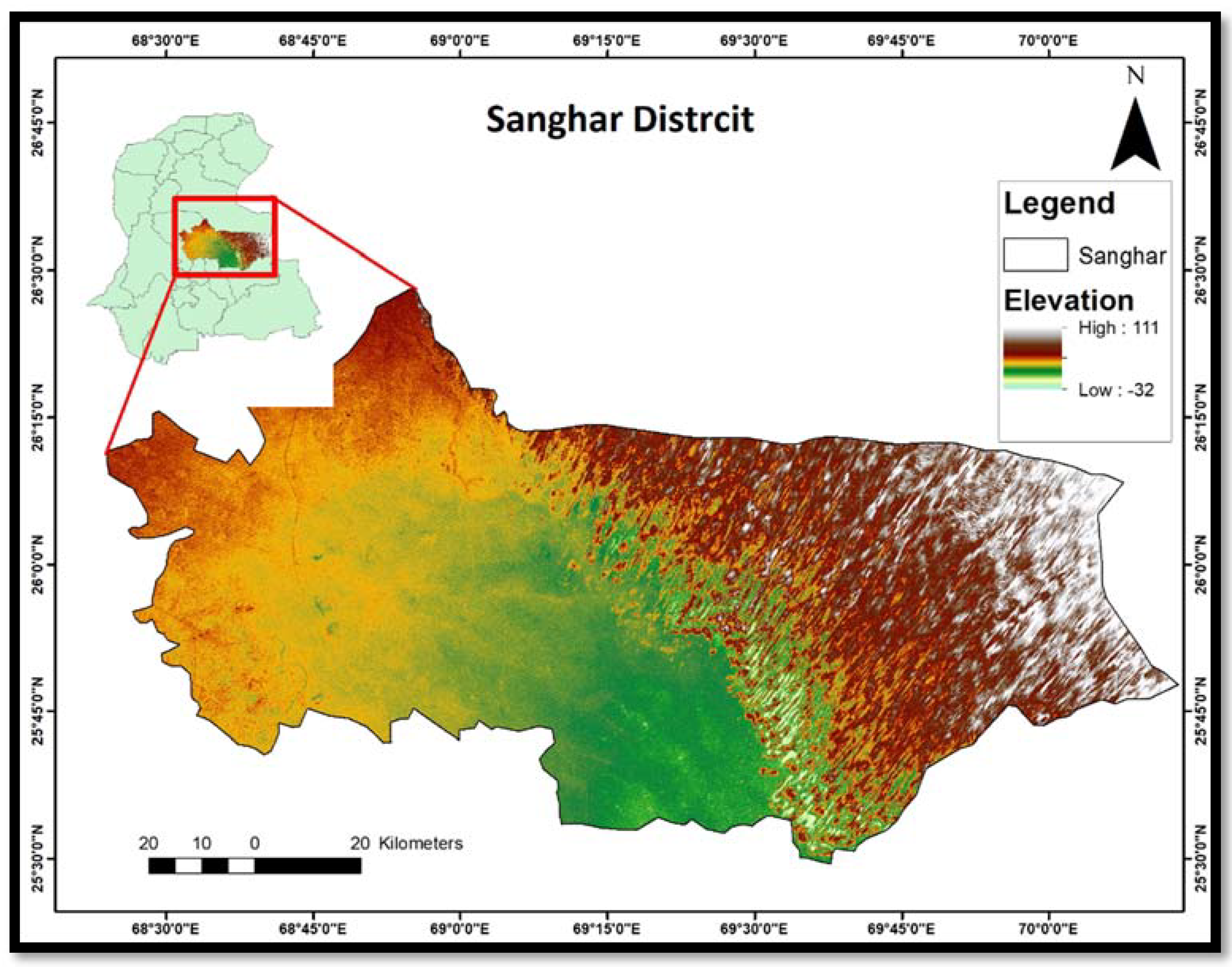
2. Methodology
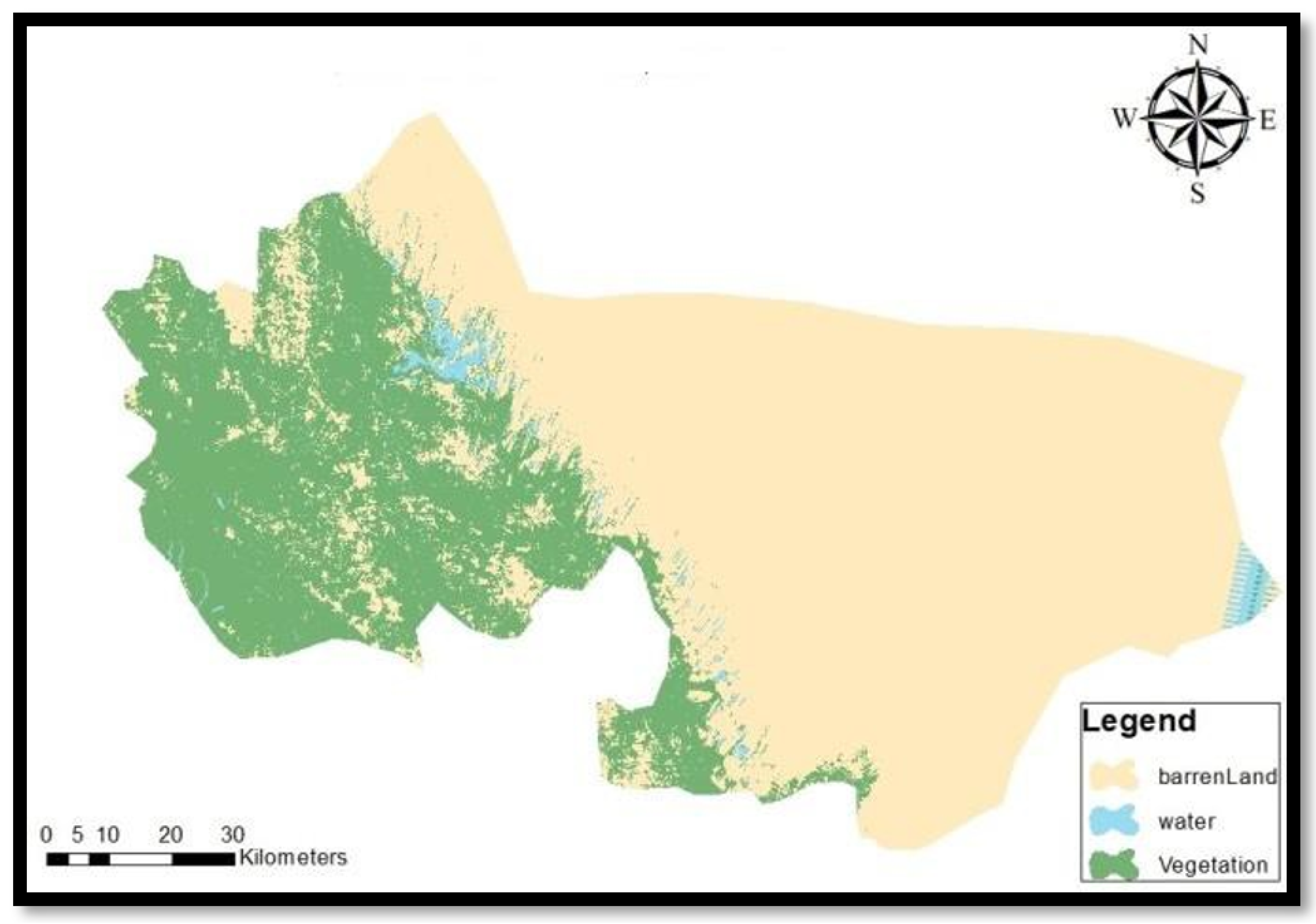
2.1. Study Data
2.2. Data Analysis
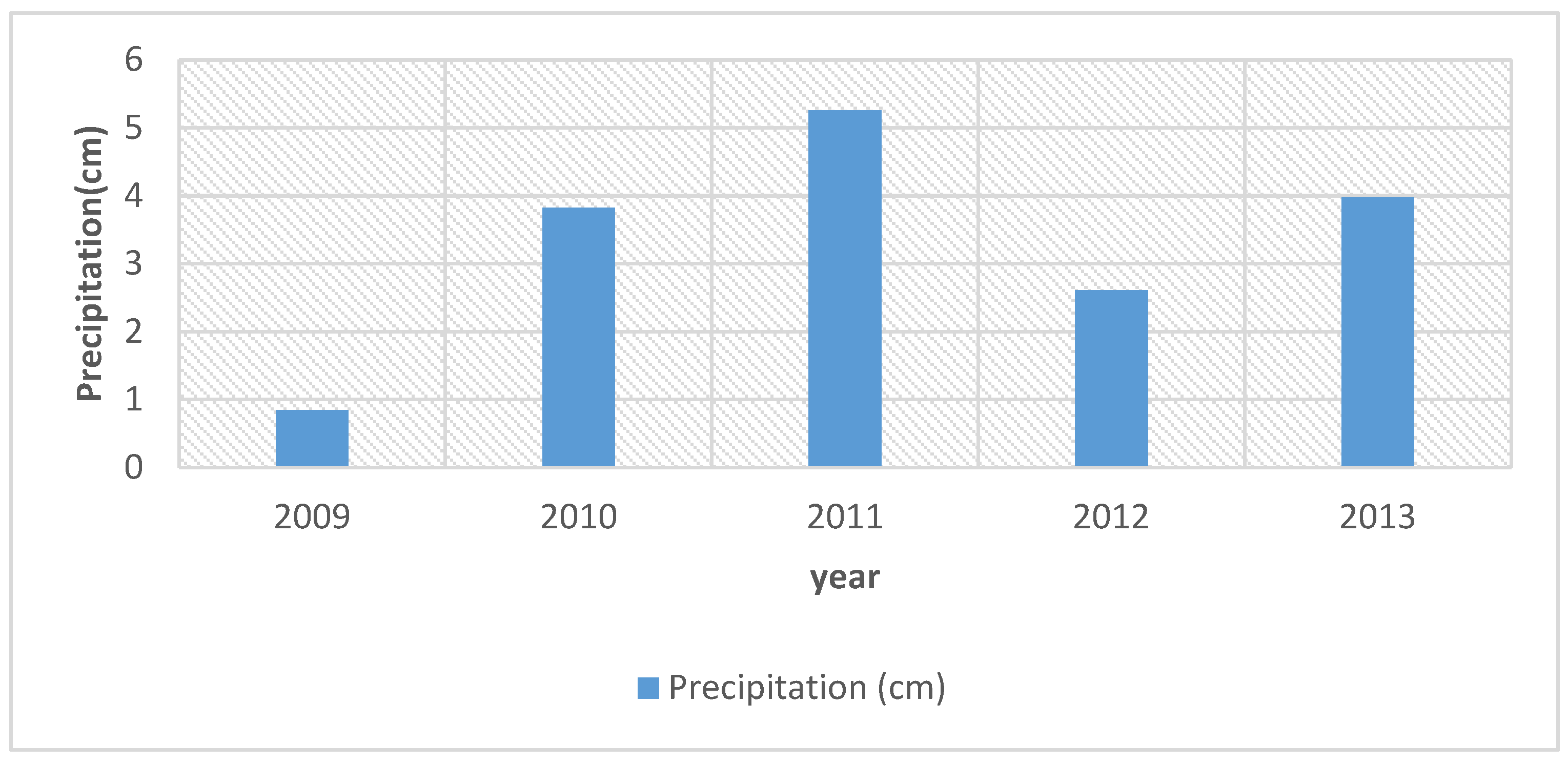
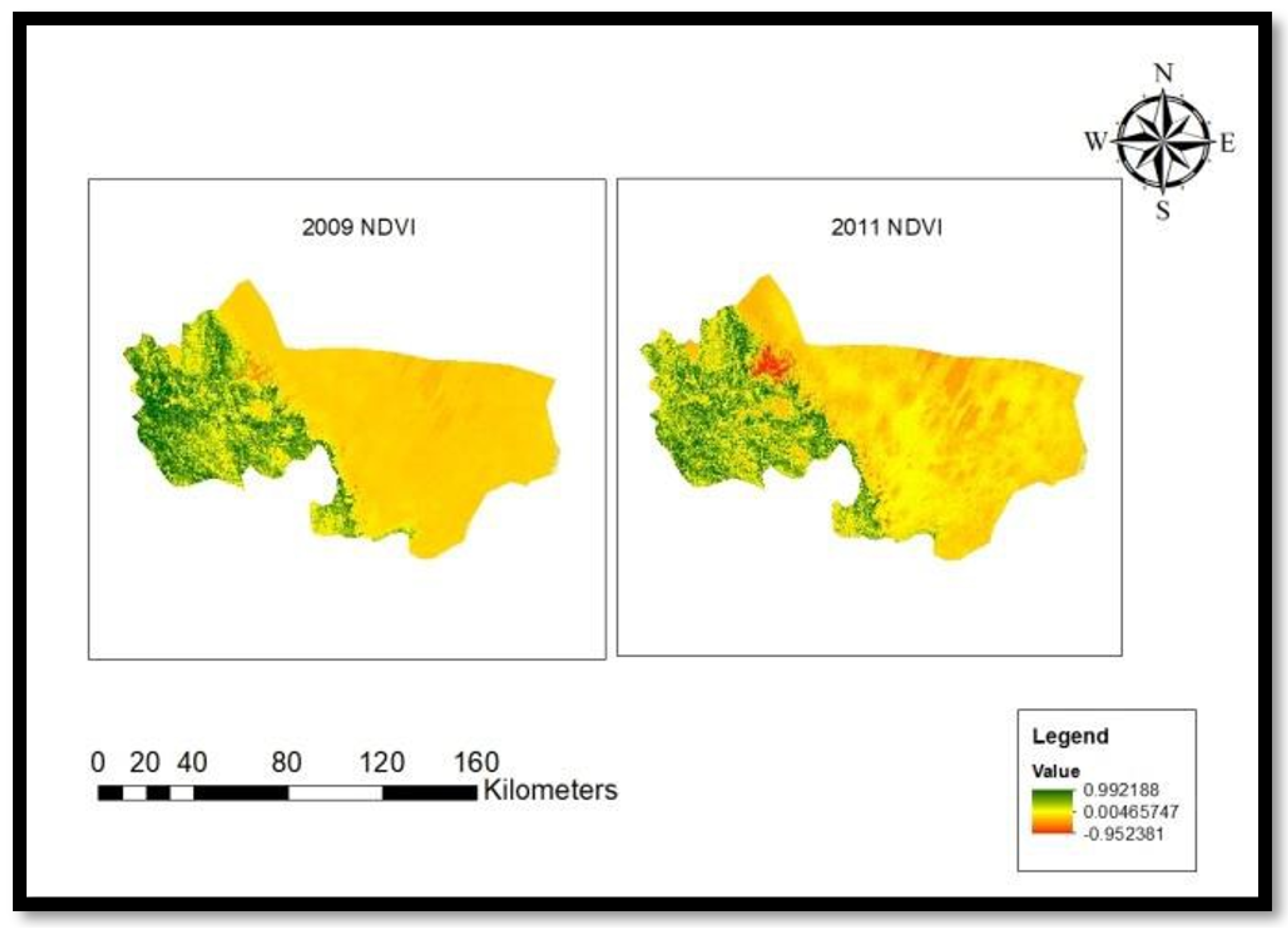
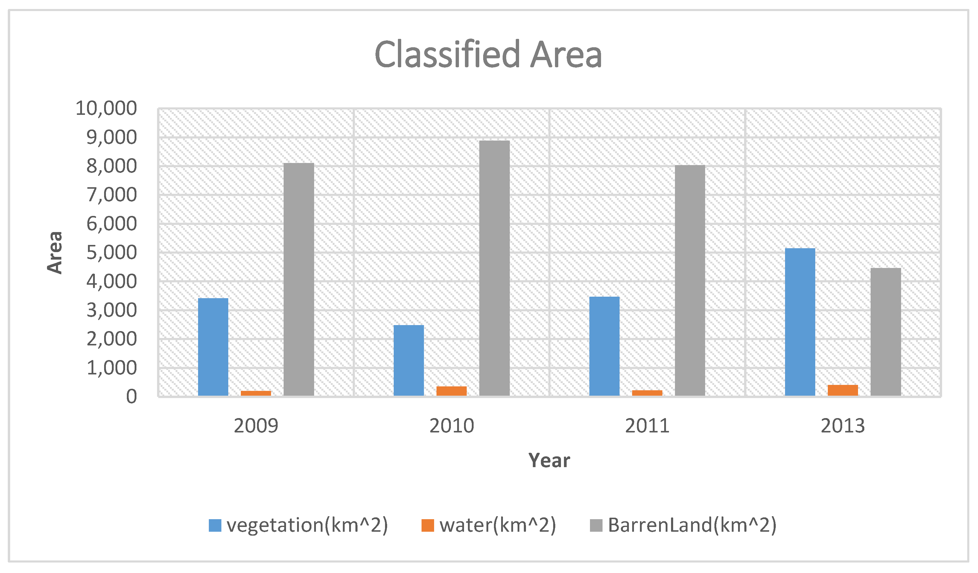
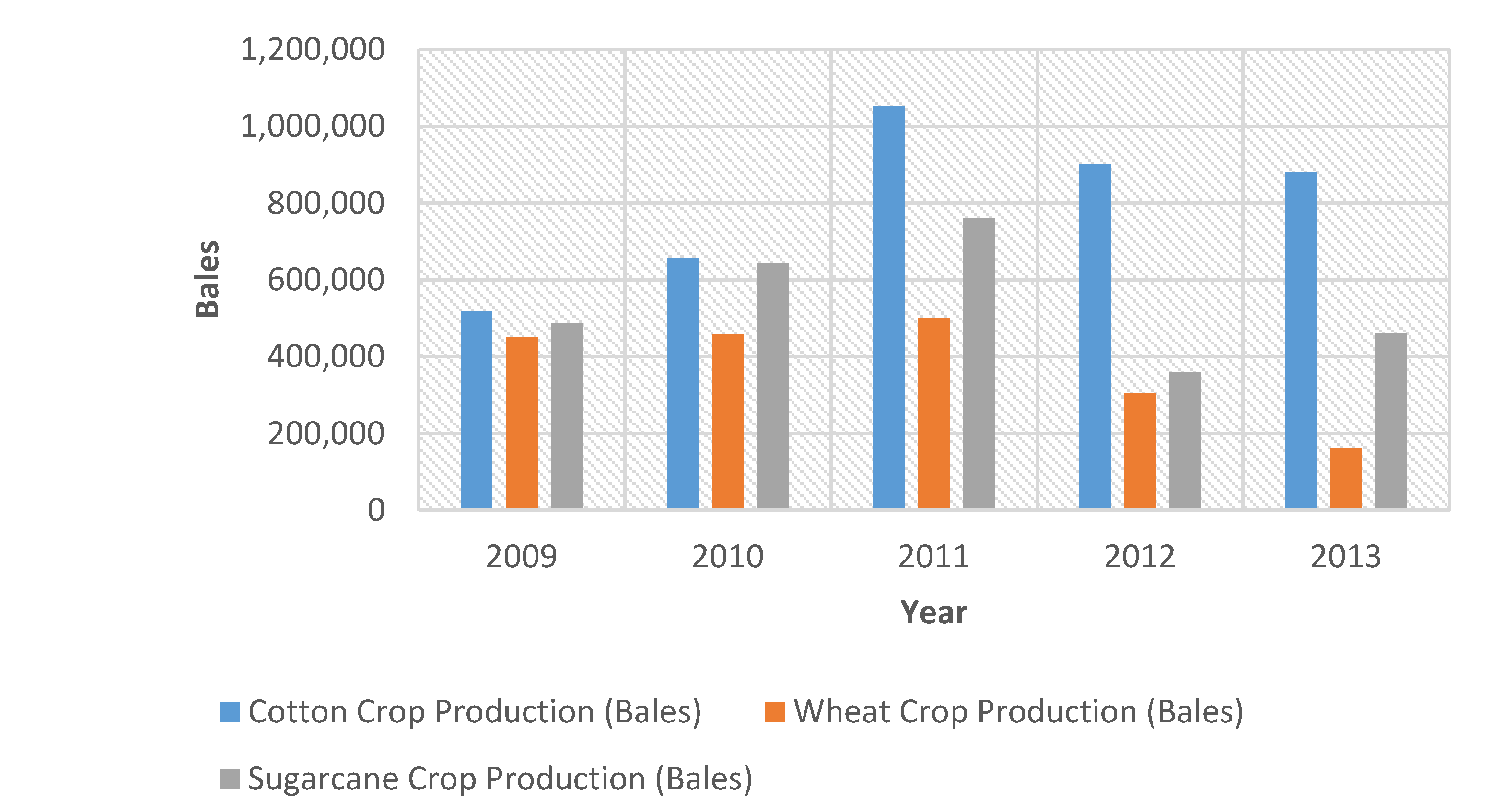
3. Results
4. Discussions
5. Conclusions
- Although crops were severely affected during the flood, soon after the flood, an increase in the vegetative cover presented a positive impact of the disaster.
- This study also validated the reports of different news and media agencies about the positive impacts of the flood in the Sanghar district.
- Data and results from the Pakistan Bureau of Statistics (PBS) and Agriculture Department Sindh also validated the study result by showing an increase in crop production and vegetation cover in the Sanghar district.
- Although the positive impact of floods, possibly due to the addition of fertile soils, is evident from study results, this impact could not sustain long. Therefore, it is suspected that the positive effect of the flood was temporary. Analyzing more extended post-flood satellite data will reveal the actual situation.
6. Recommendations
- Further extended period studies should be carried out with field surveys to analyze the positive and negative impacts of the floods on the Sanghar district and their effects on crop production.
- Disaster Risk Management Plan of the district Sanghar, which is already drafted [9], should be implemented and incorporated in decision-making.
Author Contributions
Funding
Informed Consent Statement
Data Availability Statement
Acknowledgments
Conflicts of Interest
Abbreviations
| GDP | Gross domestic product |
| GIS | Geographical Information System |
| LULC | land-use/cover |
| NCEP | National Centers for Environmental Prediction |
| NDVI | Normalized Difference Vegetation Index |
| PBS | Pakistan Bureau of Statistics |
| USGS | United States Geological Survey |
References
- Pakistan Battles Economic Pain of Floods by Sajjad Tarakzai, 19 August 2010. Available online: https://web.archive.org/web/20100927062703/http://www.thejakartaglobe.com/afp/pakistan-battles-economic-pain-of-floods/392220 (accessed on 3 September 2018).
- Disaster Risk Management Plan District Sanghar, Government of Sindh. Available online: http://www.pdma.gos.pk/new/Preparedness/DRM_Plan/Sanghar.pdf (accessed on 3 September 2018).
- Memon, N. Climate Change and Natural Disasters in Pakistan; Strengthening Participatory Organization (SPO): Islamabad, Pakistan, 2012. [Google Scholar]
- Rehman, A.; Jingdong, L.; Du, Y.; Khatoon, R.; Wagan, S.A.; Nisar, S.K. Flood disaster in Pakistan and its impact on agriculture growth (a review). Environ. Dev. Econ. 2016, 6, 39–42. [Google Scholar]
- Positive Effects of Floods by Mohiuddin Zakaria, 6 August 2011. Available online: https://www.thedailystar.net/news-detail-197343 (accessed on 6 September 2018).
- Government of Sindh Rehabilitation Department. Sindh Provincial Monsoon/Floods Contingency Plan 2011 (DRAFT VERSION 1.0). Undated. Available online: http://pdma.gos.pk/new/docs/download/13sindhcontigencyplan.pdf (accessed on 9 October 2018).
- Dawn. Impact of Floods on Sindh, 26 December 2011. From InpaperMagazine. Available online: www.dawn.com/news/683298 (accessed on 2 February 2019).
- GOP. Annual Flood Report 2011. Government of Pakistan, Ministry of Water and Power. Undated. Available online: http://mowr.gov.pk/wp-content/uploads/2018/06/Annual-Flood-Report-2011.pdf (accessed on 10 February 2019).
- Sanghar, D. District SANGHAR. Available online: http://www.pdma.gov.pk/new/Preparedness/DRM_Plan/Sanghar.pdf (accessed on 15 February 2019).

| Description of Years | Periods |
|---|---|
| Base year/pre-flood | 5 June 2009–30 September 2009 |
| Flood years | 5 June 2010–2011 September 2009 |
| Post-flood years | 5 June 2012–2013 September 2009 |
Publisher’s Note: MDPI stays neutral with regard to jurisdictional claims in published maps and institutional affiliations. |
© 2020 by the authors. Licensee MDPI, Basel, Switzerland. This article is an open access article distributed under the terms and conditions of the Creative Commons Attribution (CC BY) license (https://creativecommons.org/licenses/by/4.0/).
Share and Cite
Talpur, Z.; Naseer, T.; Memon, A.R.; Zaidi, A. Impact of Floods on Vegetation Cover in the Sanghar District of Sindh, Pakistan. Environ. Sci. Proc. 2021, 7, 5. https://doi.org/10.3390/ECWS-5-08009
Talpur Z, Naseer T, Memon AR, Zaidi A. Impact of Floods on Vegetation Cover in the Sanghar District of Sindh, Pakistan. Environmental Sciences Proceedings. 2021; 7(1):5. https://doi.org/10.3390/ECWS-5-08009
Chicago/Turabian StyleTalpur, Zenobia, Talal Naseer, Abdul Rafay Memon, and Arjumand Zaidi. 2021. "Impact of Floods on Vegetation Cover in the Sanghar District of Sindh, Pakistan" Environmental Sciences Proceedings 7, no. 1: 5. https://doi.org/10.3390/ECWS-5-08009
APA StyleTalpur, Z., Naseer, T., Memon, A. R., & Zaidi, A. (2021). Impact of Floods on Vegetation Cover in the Sanghar District of Sindh, Pakistan. Environmental Sciences Proceedings, 7(1), 5. https://doi.org/10.3390/ECWS-5-08009