
Evaluation of Agriculture-Related Climate Indices in Hindcast COSMO-CLM Simulations over Central Europe †


Abstract
:1. Introduction
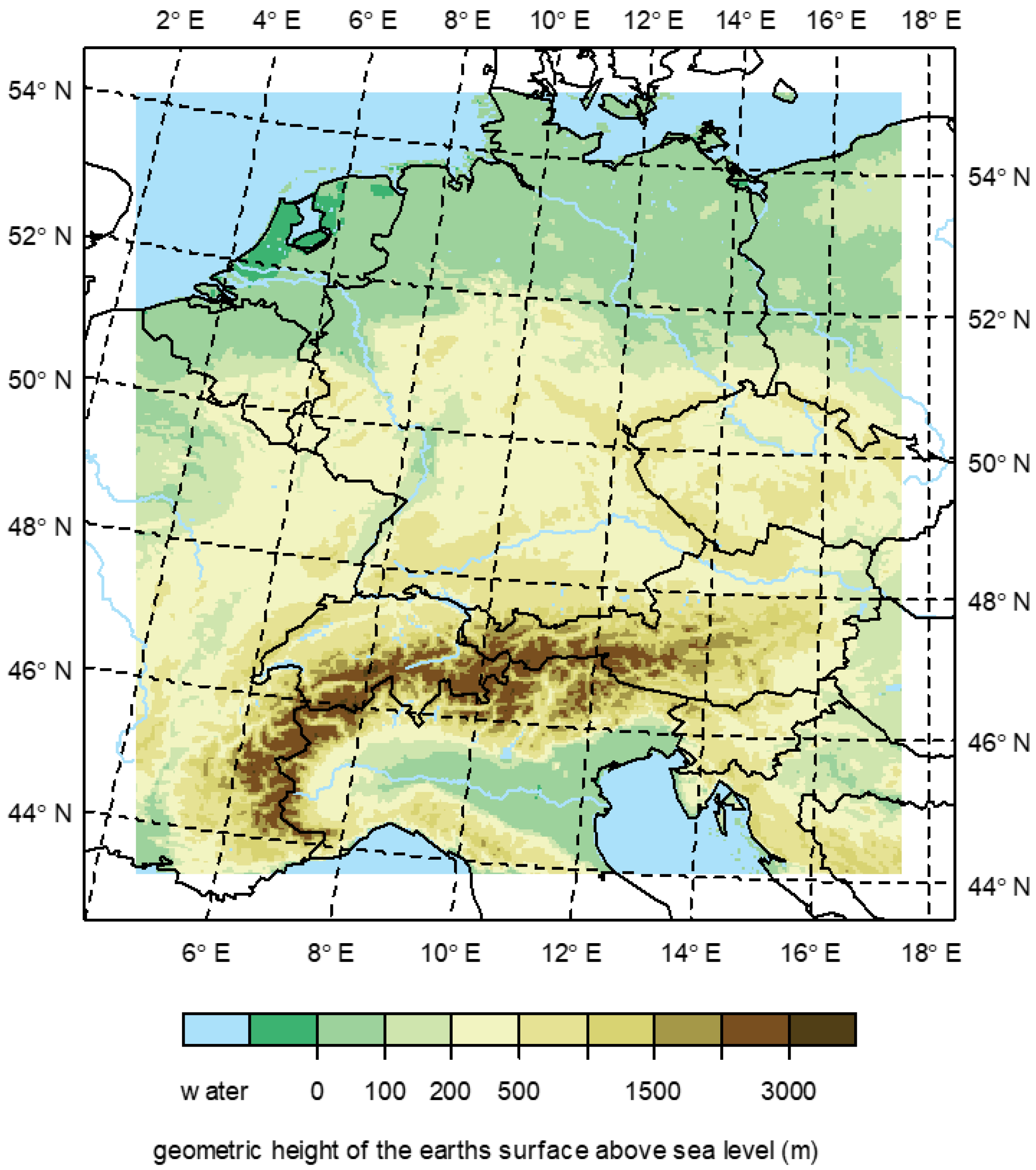
2. Methods
2.1. Model
2.2. Statistical Analysis
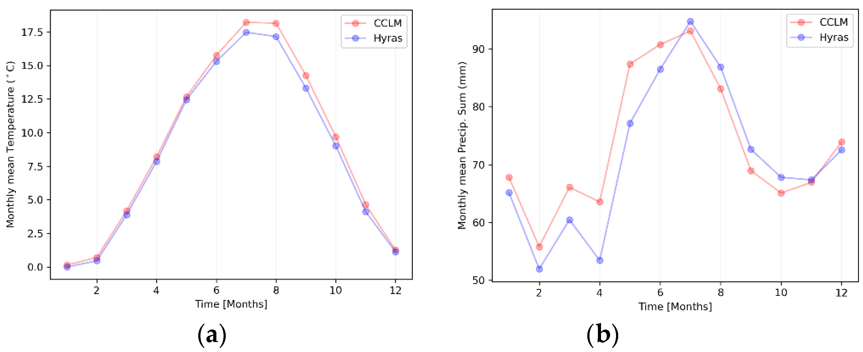
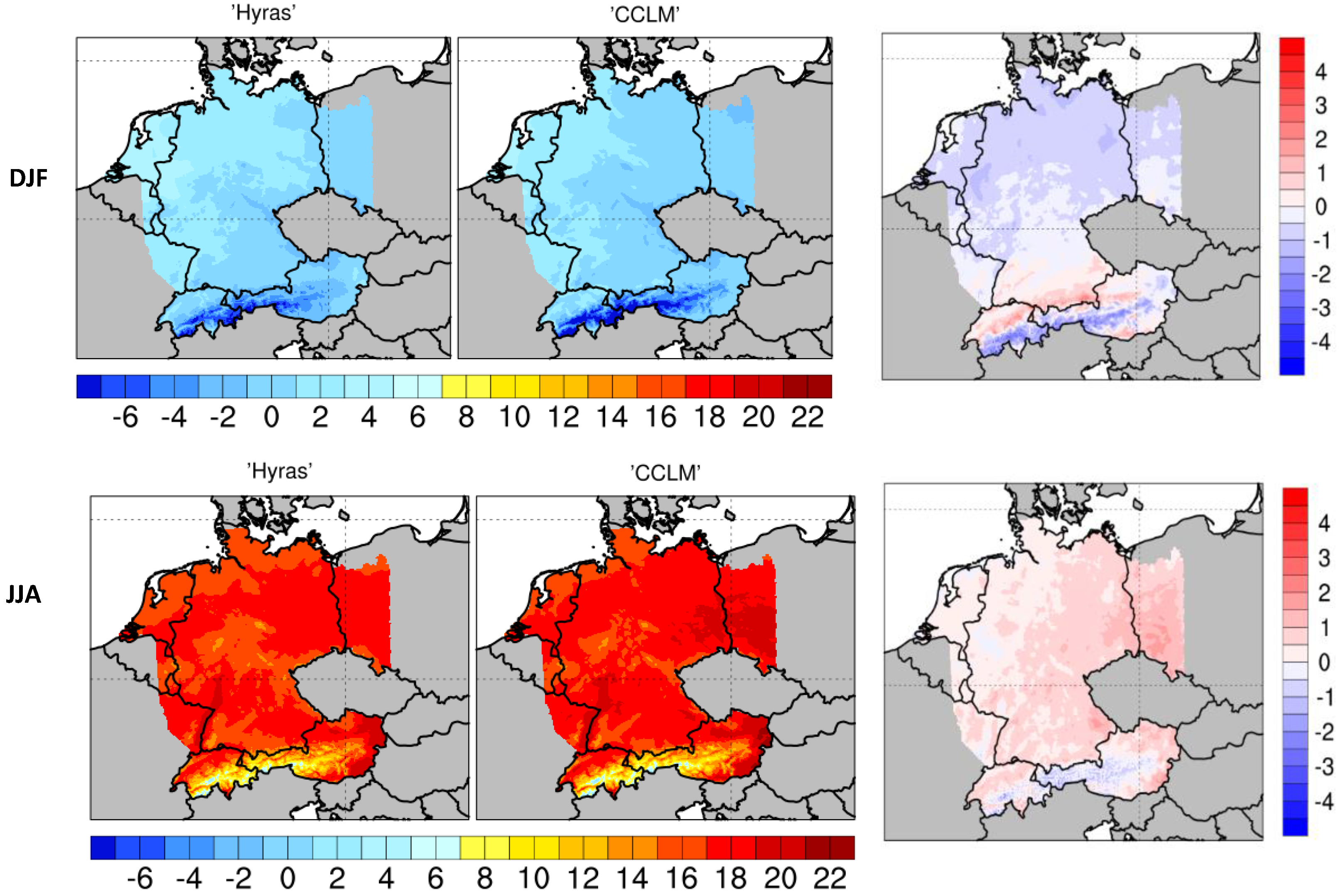
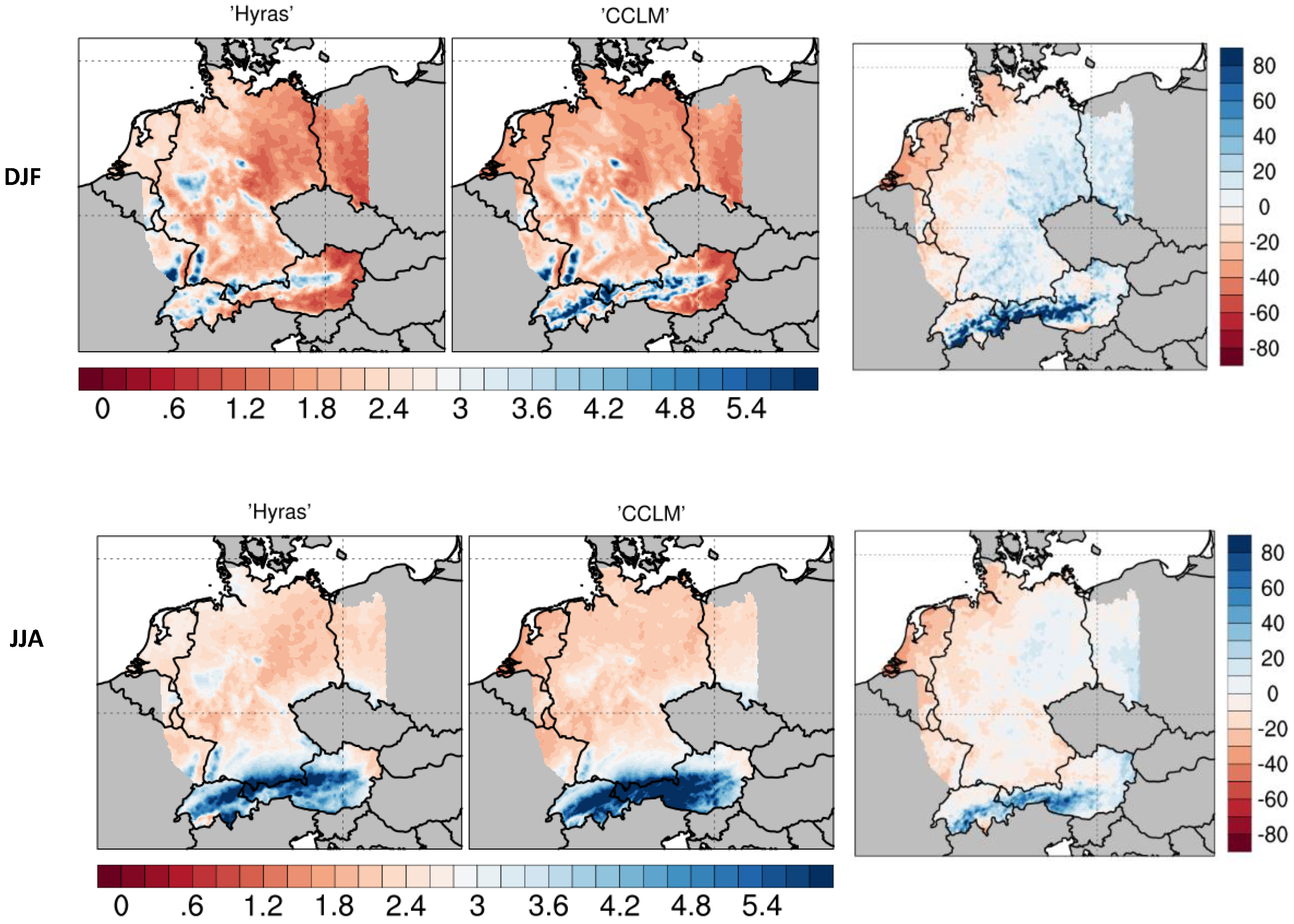
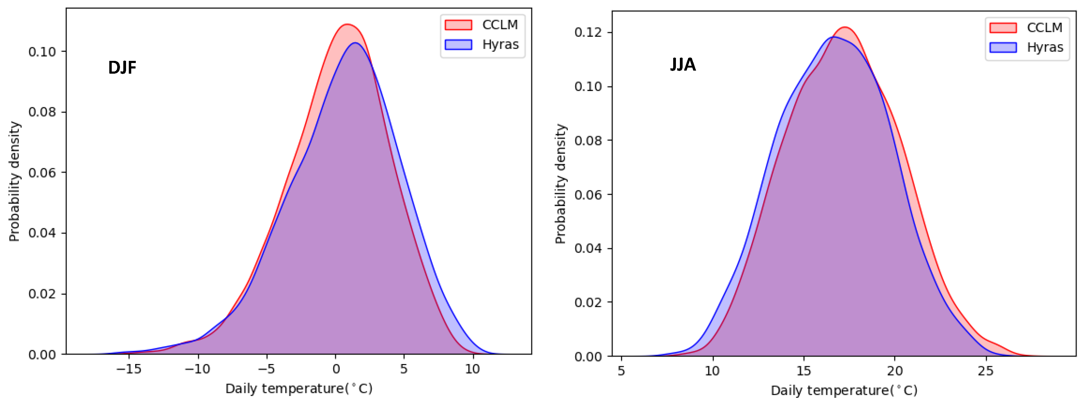
3. Results and Discussion
4. Summary and Conclusions
Institutional Review Board Statement
Informed Consent Statement
Acknowledgments
References
- Ban, N.; Brisson, E.; Caillaud, C.; Coppola, E.; Pichelli, E.; Sobolowski, S.; Adinolfi, M.; Alias, A.; Anders, I.; Bastin, S.; et al. The first multi-model ensemble of regional climate simulations at the kilometer-scale resolution, Part I: Evaluation of precipitation. Clim. Dyn. 2021, 57, 275–303. [Google Scholar] [CrossRef]
- Christensen, J.; Carter, T.; Mea, R. Evaluating the performance and utility of regional climate models: The PRUDENCE project. Clim. Chang. 2007, 81, 1–6. [Google Scholar] [CrossRef]
- Giorgi, F. Thirty years of regional climate modeling: Where are we and where are we going next? J. Geophys. Res. Atmos. 2019, 124, 5696–5723. [Google Scholar] [CrossRef]
- Kotlarski, S.; Keuler, K.; Christensen, O.B.; Colette, A.; Deque, M.; Gobiet, A.; Goergen, K.; Jacob, D.; Luüthi, D.; van Meijgaard, E.; et al. Regional climate modeling on European scales: A joint standard evaluation of the EURO-CORDEX RCM ensemble. Geosci. Model. Dev. Discuss. 2014, 7, 217–293. [Google Scholar] [CrossRef]
- Prein, A.F.; Langhans, W.; Fosser, G.; Ferrone, A.; Ban, N.; Goergen, K.; Keller, M.; Tölle, M.; Gutjahr, O.; Feser, F.; et al. A review on regional convection-permitting climate modeling: Demonstrations, prospects, and challenges. Rev. Geophys. 2015, 53, 323–361. [Google Scholar] [CrossRef] [PubMed]
- Kendon, E.J.; Roberts, N.M.; Fowler, H.J.; Roberts, M.J.; Chan, S.C.; Senior, C.A. Heavier summer downpours with climate change revealed by weather forecast resolution model. Nat. Clim. Chang. 2014, 4, 570–576. [Google Scholar] [CrossRef]
- Ban, N.; Schmidli, J.; Schaär, C. Evaluation of the convection-resolving regional climate modeling approach in decade-long simulations. J. Geophys. Res. Atmos. 2014, 119, 7889–7907. [Google Scholar] [CrossRef]
- Tölle, M.H.; Gutjahr, O.; Thiele, J.; Busch, G. Increasing bioenergy production on arable land: Does the regional and local climate respond? J. Geophys. Res. Atmos. 2014, 119, 2711–2724. [Google Scholar] [CrossRef]
- Tölle, M.H.; Schefczyk, L.; Gutjahr, O. Scale dependency of regional climate modeling of current and future climate extremes in Germany. Theor. Appl. Climatol. 2018, 134, 829–848. [Google Scholar] [CrossRef]
- Leutwyler, D.; Luüthi, D.; Ban, N.; Fuhrer, O.; Schär, C. Evaluation of the convection-resolving climate modeling approach on continental scales. J. Geophys. Res.-Atmos. 2017. [Google Scholar] [CrossRef]
- Coppola, E.; Sobolowski, S.; Pichelli, E.; Raffaele, F.; Ahrens, B.; Anders, I.; Ban, N.; Bastin, S.; Belda, M.; Belusic, D.; et al. A first-of-its-kind multi-model convection permitting ensemble for investigating convective phenomena over europe and the mediterranean. Clim. Dyn. 2020, 1–32. [Google Scholar] [CrossRef]
- Rasmussen, R.; Liu, C.; Ikeda, K.; Gochis, D.; Yates, D.; Chen, F.; Tewari, M.; Barlage, M.; Dudhia, J.; Yu, W.; et al. High-resolution coupled climate runoff simulations of seasonal snowfall over colorado: A process study of current and warmer climate. J. Clim. 2011, 24, 3015–3048. [Google Scholar] [CrossRef]
- Liu, C.; Ikeda, K.; Rasmussen, R.; Barlage, M.; Newman, A.J.; Prein, A.F.; Chen, F.; Chen, L.; Clark, M.; Dai, A.; et al. Continental-scale convection-permitting modeling of the current and future climate of North America. Clim. Dyn. 2017, 49, 71–95. [Google Scholar] [CrossRef]
- Rockel, B.; Will, A.; Hense, A. The regional climate model COSMO-CLM (CCLM). Meteorologische Zeitschrift 2008, 17, 347–348. [Google Scholar] [CrossRef]
- Baldauf, M.; Seifert, A.; Förstner, J.; Majewski, D.; Raschendorfer, M.; Reinhardt, T. Operational convection-scale numerical weather prediction with the COSMO model: Description and sensitivities. Mon. Weather Rev. 2011, 139, 3887–3905. [Google Scholar] [CrossRef]
- Arakawa, A.; Lamb, V. Computational design of the basic dynamical processes in the UCLA general circulation model. In Methods in Computational Physics: General Circulation Models of the Atmosphere; Chang, J., Ed.; Academic Press: New York, NY, USA, 1977; Volume 17, pp. 173–265. [Google Scholar] [CrossRef]
- Wicker, L.J.; Skamarock, W.C. Time-Splitting Methods for Elastic Models Using Forward Time Schemes. Mon. Weather Rev. 2002, 130(8), 2088–2097. [Google Scholar] [CrossRef]
- Doms, G.; Baldauf, M. A Description of the Non-Hydrostatic Regional COSMO Model, Part I: Dynamics and Numerics; Offenbach: Germany, 2015. [Google Scholar]
- Schrodin, E.; Heise, E. A New Multi-Layer Soil Model; COSMO Newsletter No. 2:149–151; German Weather Service: Offenbach: : Germany, 2002. [Google Scholar]
- Ritter, B.; Geleyn, J.F. A comprehensive radiation scheme for numerical weather prediction models with potential applications in climate simulations. Mon. Weather Rev. 1992, 120, 303–325. [Google Scholar] [CrossRef]
- Raschendorfer, M. The New Turbulence Parametrization of LM; COSMO Newsletter No. 1:90-98; German Weather Service: Offenbach: Germany, 2001. [Google Scholar]
- Hersbach, H.; de Rosnay, P.; Bell, B.; Schepers, D.; Simmons, A.; Soci, C.; Abdalla, S.; Alonso-Balmaseda, M.; Balsamo, G.; Bechtold, P.; et al. Operational Global Reanalysis: Progress, Future Directions and Synergies with NWP; ERA Report Series 27; ECMWF: Reading, UK, 2018. [Google Scholar]
- Razafimaharo, C.; Krähenmann, S.; Höpp, S.; Rauthe, M.; Deutschländer, T. New high-resolution gridded dataset of daily mean, minimum, and maximum temperature and relative humidity for Central Europe (HYRAS). Theor. Appl. Climatol. 2020, 142, 1531–1553. [Google Scholar] [CrossRef]
- Tschurr, F.; Feigenwinter, I.; Fischer, A.M.; Kotlarski, S. Climate Scenarios and Agricultural Indices: A Case Study for Switzerland. Atmosphere 2020, 11, 535. [Google Scholar] [CrossRef]
- Lundquist, J.; Hughes, M.; Gutmann, E.; Kapnick, S. Our Skill in Modeling Mountain Rain and Snow is Bypassing the Skill of Our Observational Networks. Bull. Am. Meteorol. Soc. 2020, 100, 2473–2490. [Google Scholar] [CrossRef]
- Liu, X.; Xie, S.; Boyle, J.; Klein, S.A.; Shi, X.; Wang, Z.; Lin, W.; Ghan, S.J.; Earle, M.; Liu, P.S.K.; et al. Testing cloud microphysics parameterizations in NCAR CAM5 with ISD AC and M-PACE observations. J. Geophys. Res. 2011, 116. [Google Scholar] [CrossRef]


| CDD | Consecutive Dry Days | The number of dry periods of more than 5 days, PR < 1 mm |
| CWD | Consecutive Wet Days | The number of wet periods of more than 5 days, PR ≥ 1 mm |
| ID | Ice Days | The number of icy days with TX < 0 °C |
| CFD | Consecutive Frost Days | The number of frost periods of more than 5 days, TN < 0 °C |
| CSU | Consecutive Summer Days | The number of summer periods of more than 5 days, TX > 25 °C |
| GSL | Growing Season Length | The number of days between: first occurrence of at least 6 consecutive days with TG > 5 °C, first occurrence of at least 6 consecutive days with TG < 5 °C within the last 6 months |
| GSL2 | Growing Season Starting Day | The first occurrence of at least 6 consecutive days with TG > 5 °C |
Publisher’s Note: MDPI stays neutral with regard to jurisdictional claims in published maps and institutional affiliations. |
© 2020 by the authors. Licensee MDPI, Basel, Switzerland. This article is an open access article distributed under the terms and conditions of the Creative Commons Attribution (CC BY) license (https://creativecommons.org/licenses/by/4.0/).
Share and Cite
Zhang, H.; Tölle, M.H. Evaluation of Agriculture-Related Climate Indices in Hindcast COSMO-CLM Simulations over Central Europe. Environ. Sci. Proc. 2021, 4, 27. https://doi.org/10.3390/ecas2020-08464
Zhang H, Tölle MH. Evaluation of Agriculture-Related Climate Indices in Hindcast COSMO-CLM Simulations over Central Europe. Environmental Sciences Proceedings. 2021; 4(1):27. https://doi.org/10.3390/ecas2020-08464
Chicago/Turabian StyleZhang, Huan, and Merja H. Tölle. 2021. "Evaluation of Agriculture-Related Climate Indices in Hindcast COSMO-CLM Simulations over Central Europe" Environmental Sciences Proceedings 4, no. 1: 27. https://doi.org/10.3390/ecas2020-08464
APA StyleZhang, H., & Tölle, M. H. (2021). Evaluation of Agriculture-Related Climate Indices in Hindcast COSMO-CLM Simulations over Central Europe. Environmental Sciences Proceedings, 4(1), 27. https://doi.org/10.3390/ecas2020-08464