Abstract
Due to rapid urban growth and population increase, accurately tracking land use and cover changes (LULC) is vital for predicting outdoor thermal comfort. We used high-res Landsat 8 imagery and on-site weather data, employing a Support Vector Machine (SVM) with PCA to estimate thermal comfort. The PCA addressed variable multicollinearity, and LULC was classified using decision trees. Notable LULC trends emerged. In Hyderabad, built-up areas rose from 37% to 48% (2009–2019) and barren lands fell from 42% to 18%. In Bangalore, built-up areas surged from 25% to 80%, causing vegetation loss (25% to 2%) and reduced barren land (50% to 18%). Jaipur saw a 12% built-up area increase with a slight vegetation uptick. The thermal comfort analysis highlighted Bangalore’s intense urbanization and Jaipur’s limited expansion. Discomfort ranked highest in barren lands, followed by urban, vegetation, and water areas.
1. Introduction
Rapid urbanization increases Land Surface Temperature (LST), impacting outdoor thermal comfort, residents’ health, and daily life. Thermal comfort depends on meteorological factors like air temperature, humidity, radiant temperature, and wind speed. Urban expansion alters these factors, affecting local weather conditions. With more people in urban areas (https://data.worldbank.org/indicator/SP.URB.TOTL.IN.ZS?, accessed on 11 May 2022), outdoor thermal discomfort can lead to health problems, including dehydration, eye strain, dizziness, and respiratory/cardiovascular issues [1,2]. To address this, city planning should consider mitigation strategies to modify meteorological parameters like air temperature, humidity, local wind patterns, and albedo. So, this study aims to predict the thermal comfort levels by using Landsat imagery to provide necessary information to policymakers to plan a city. In early studies, people estimated thermal comfort by taking synoptic observations in a city, such as [3,4,5,6,7], but these single-point studies do not adequately represent spatial patterns over the region. So, people started considering LST as a proxy for thermal comfort and the analysis of spatial patterns [8,9,10,11,12]. Again, LST alone is insufficient to represent thermal comfort; thus, we adopted regression-based methodologies to analyze thermal comfort. This kind of study was adopted in the city of Theran [13], and the researchers utilized OLS (ordinary least square) regression to estimate thermal comfort. In the present study, we used an advanced machine learning technique to estimate thermal comfort.
2. Material and Methods
2.1. Study Area and Data
The main aim of this study is to assess the thermal comfort in metropolitan cities of India. For this purpose, we chose three major cities across India where synoptic observation stations exist. The study area includes different climatological areas according to the Köppen climate classification. Since we are interested in studying micro-scale thermal comfort, we chose mandal/sub-administrative boundaries within cities, as shown in Figure 1.

Figure 1.
Cities with sub-administrative boundaries. (a) Hyderabad (b) Banglore (c) Jaipur.
2.2. Data
The observed synoptic station data are for the period of 2009–2020, including daily meteorological data at airports, comprising wind speed, wind direction, temperature, and relative humidity, taken from Kaggle (https://doi.org/10.34740/KAGGLE/DSV/1129180, accessed on 11 May 2022). The daily observed meteorological data consist of maximum and minimum values of temperature (Ta,℃, relative humidity (RH, %), and wind speed (V, ms−1) of 16 mandals of Hyderabad city The meteorological data were collected from an open data source: https://data.telangana.gov.in/, accessed on 11 May 2022.
2.3. Satellite Data
Landsat multispectral bands are used for the period of 2009–2020, with a resolution of 30 m × 30 m and a cloud cover of less than 20%. The above data sets were obtained from the USGS Earth Explorer user Interface (https://earthexplorer.usgs.gov/, accessed on 11 May 2022).
2.4. Methodology
- We acquired the real-time data of meteorological variables over different locations within a city, estimating the thermal comfort index using the below THI formula at those locations.
- We estimated the environmental parameters at those locations that influence thermal comfort. The environmental parameters include NDVI, NDWI, LST, etc. These can be estimated from satellite imagery data such as Landsat, MODIS, etc.
- We conducted a principal component analysis.
- Using machine learning techniques, we created thermal comfort maps with a fine resolution.
3. Results
3.1. Hyderabad
Hyderabad city, with 16 mandals, is considered for the assessment of thermal comfort. Before analyzing the thermal comfort, the LULC over Hyderabad is estimated. Hyderabad’s built-up are increased from 37% to 48% from 2009 to 2019. Substantially, there was a decrease in barren land from 42% to 18% from 2009 to 2019. The percentages of water bodies are almost the same, with an area of 3% occupied in the city. Interestingly, there was an increase in vegetation from 20% to 30%.
The built-up are of Hyderabad city was substantially increased, but most of the greenery was almost the same. Most of the conversion of the built-up are was from bare lands, which in turn may alter the thermal comfort. So, in order to analyze the spatial variation of the thermal comfort in detail, the mandal-level thermal comfort is plotted and analyzed.
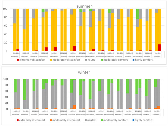
In Figure 2, the results clearly portray the fact that there was a substantial increase in the built-up area from 2009 to 2019, as well as an associated linear increase in thermal discomfort. Mandals like Secunderabad have the largest water bodies and achieve maximum thermal comfort. Again, mandals like Nampally and Charminar have the most built-up land and barren land, resulting in maximum discomfort. Similarly, in winter, most of the mandals turned to neutral conditions in 2019 from the moderately comfortable conditions in 2009. Charminar and Himayatnagar witnessed the most urbanization, resulting in discomfort.

Figure 2.
Outdoor thermal comfort changes of Hyderabad from 2009 to 2019.
3.2. Bangalore
Bangalore was subdivided into five major parts. Drastic urbanization was seen in the city and maximum vegetation loss was observed. Bangalore’s built-up area increased from 25% to 80% from 2009 to 2019. Its vegetation decreased from 25% to 2%, and barren lands decreased from 50% to 18%. A huge vegetation loss was observed. There was a slight decrease in water bodies during the study period, and most of the barren lands and vegetative lands turned into built-up areas.
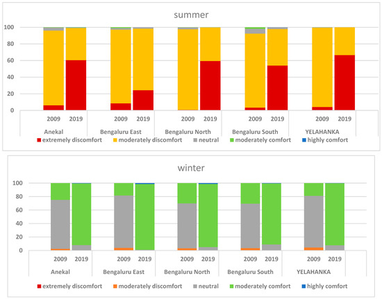
In Figure 3, every subdivision of Bangalore shows moderate discomfort in 2009, which turned to high discomfort in 2019. Very few water bodies are observed across Bangalore, resulting in very few comfortable zones throughout the city. A contrasting situation is shown in winter, where most zones of Bangalore had comfortable conditions from 2009 to 2019.

Figure 3.
Outdoor thermal comfort changes of Bangalore from 2009 to 2019.
3.3. Jaipur
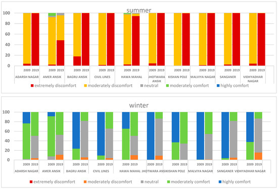
There was a slight increase in vegetation, and mostly barren land loss was observed. Figure 4 shows the ward-level thermal comfort assessment over Jaipur city. In summer, Jhotwara Ansik and Kishan Pole showed maximum discomfort from 2009 to 2019. Almost all wards exhibited moderate discomfort in 2009, which turned to high discomfort in 2019. Only Amer Ansik has a small portion of water bodies, resulting in moderate comfort and neutral conditions in 2009.

Figure 4.
Outdoor thermal comfort changes of Jaipur from 2009 to 2019.
The overall discomfort was very poor compared to the remaining cities in summer. But the comfort conditions in winter were highly comfortable in all wards, portraying very low LSTs throughout the city during winter. Jhotwara Ansik and Malviya Nagar experienced maximum comfort in 2009, which turned neutral in 2019. Unlike other cities, some portion of moderate discomfort prevailed throughout the city during the winter of 2019.
4. Discussion and Conclusions
The above method relies on environmental parameters that can be retrieved from satellite imagery to assess thermal comfort. This method is highly useful for analyzing thermal comfort with corresponding LULC, especially where the in situ data are absent. From the above analysis, there has been an increase in discomfort in the past decade in all three cities. This can be easily associated with the corresponding increase in built-up areas, but this model’s major limitation is that it relies primarily on LST and other surface parameters. However, T2m, humidity, and wind will substantially change from the surface. So, this model is a preliminary vision for policymakers to plan mitigation strategies; however, more research is needed to obtain insights into thermal comfort.
Author Contributions
All authors contributed to the study conception and design. Material preparation, data collection and analysis were performed by P.S.H.P. and A.N.V.S. The first draft of the manuscript was written by P.S.H.P. and correction done by A.N.V.S. All authors have read and agreed to the published version of the manuscript.
Funding
This research received no external funding.
Institutional Review Board Statement
Not applicable.
Informed Consent Statement
Not applicable.
Data Availability Statement
The data to reproduce the manuscript are given in data section and all these data available from public reporsitories for free.
Conflicts of Interest
The authors declare no conflict of interest.
References
- Buchin, O.; Hoelscher, M.T.; Meier, F.; Nehls, T.; Ziegler, F. Evaluation of the Health-Risk Reduction Potential of Countermeasures to Urban Heat Islands. Energy Build 2016, 114, 27–37. [Google Scholar] [CrossRef]
- Xiong, J.; Lian, Z.; Zhou, X.; You, J.; Lin, Y. Effects of Temperature Steps on Human Health and Thermal Comfort. Build Environ. 2015, 94, 144–154. [Google Scholar] [CrossRef]
- Ali, S.B.; Patnaik, S. Thermal Comfort in Urban Open Spaces: Objective Assessment and Subjective Perception Study in Tropical City of Bhopal, India. Urban Clim. 2018, 24, 954–967. [Google Scholar] [CrossRef]
- Kumar, P.; Sharma, A. Assessing the Outdoor Thermal Comfort Conditions of Exercising People in the Semi-Arid Region of India. Sustain. Cities Soc. 2022, 76, 103366. [Google Scholar] [CrossRef]
- Ziaul, S.; Pal, S. Assessing Outdoor Thermal Comfort of English Bazar Municipality and Its Surrounding, West Bengal, India. AdSpR 2019, 64, 567–580. [Google Scholar] [CrossRef]
- Deevi, B.; Chundeli, F.A. Quantitative Outdoor Thermal Comfort Assessment of Street: A Case in a Warm and Humid Climate of India. Urban Clim. 2020, 34, 100718. [Google Scholar] [CrossRef]
- Rawal, R.; Shukla, Y.; Vardhan, V.; Asrani, S.; Schweiker, M.; de Dear, R.; Garg, V.; Mathur, J.; Prakash, S.; Diddi, S.; et al. Adaptive Thermal Comfort Model Based on Field Studies in Five Climate Zones across India. Build. Environ. 2022, 219, 109187. [Google Scholar] [CrossRef]
- Xu, H.; Hu, X.; Guan, H.; He, G. Development of a Fine-Scale Discomfort Index Map and Its Application in Measuring Living Environments Using Remotely-Sensed Thermal Infrared Imagery. Energy Build. 2017, 150, 598–607. [Google Scholar] [CrossRef]
- Shahfahad; Naikoo, M.W.; Towfiqul Islam, A.R.M.; Mallick, J.; Rahman, A. Land Use/Land Cover Change and Its Impact on Surface Urban Heat Island and Urban Thermal Comfort in a Metropolitan City. Urban Clim. 2022, 41, 101052. [Google Scholar] [CrossRef]
- Swain, D.; Roberts, G.J.; Dash, J.; Lekshmi, K.; Vinoj, V.; Tripathy, S. Impact of Rapid Urbanization on the City of Bhubaneswar, India. Proc. Natl. Acad. Sci. India Sect. A-Phys. Sci. 2017, 87, 845–853. [Google Scholar] [CrossRef]
- Kikon, N.; Singh, P.; Singh, S.K.; Vyas, A. Assessment of Urban Heat Islands (UHI) of Noida City, India Using Multi-Temporal Satellite Data. Sustain. Cities Soc. 2016, 22, 19–28. [Google Scholar] [CrossRef]
- Sharma, R.; Pradhan, L.; Kumari, M.; Bhattacharya, P. Assessing Urban Heat Islands and Thermal Comfort in Noida City Using Geospatial Technology. Urban Clim. 2021, 35, 100751. [Google Scholar] [CrossRef]
- Mijani, N.; Alavipanah, S.K.; Firozjaei, M.K.; Arsanjani, J.J.; Hamzeh, S.; Weng, Q. Modeling Outdoor Thermal Comfort Using Satellite Imagery: A Principle Component Analysis-Based Approach. Ecol. Indic. 2020, 117, 106555. [Google Scholar] [CrossRef]
Disclaimer/Publisher’s Note: The statements, opinions and data contained in all publications are solely those of the individual author(s) and contributor(s) and not of MDPI and/or the editor(s). MDPI and/or the editor(s) disclaim responsibility for any injury to people or property resulting from any ideas, methods, instructions or products referred to in the content. |
© 2023 by the authors. Licensee MDPI, Basel, Switzerland. This article is an open access article distributed under the terms and conditions of the Creative Commons Attribution (CC BY) license (https://creativecommons.org/licenses/by/4.0/).