Proceeding Paper

Unraveling the Influence of the Atlantic Subpolar Gyre on the Thermohaline Circulation in the Past 20,000 Years †

1
Irreversible Climate Change Research Center, Yonsei University, Seoul 03722, Republic of Korea
2
Department of Earth Sciences, National Central University, Taoyuan 32001, Taiwan
*
Author to whom correspondence should be addressed.
Presented at the 6th International Electronic Conference on Atmospheric Sciences, 15–30 October 2023; Available online: https://ecas2023.sciforum.net/.
Environ. Sci. Proc. 2023, 27(1), 3; https://doi.org/10.3390/ecas2023-15116
Published: 14 October 2023
(This article belongs to the Proceedings of The 6th International Electronic Conference on Atmospheric Sciences)

Abstract

:
Recent studies have suggested that there is a dynamic connection between the Atlantic Meridional Overturning Circulation (AMOC) and the North Atlantic subpolar gyre (SPG). This modeling study uses a fully coupled atmosphere–ocean–sea ice Earth system model to investigate the SPG dynamics throughout the past twenty-two thousand years. We found that the variations in the SPG and AMOC strength are synchronized. Consequently, during cold events in the Northern Hemisphere, the SPG strength declined simultaneously with the AMOC strength and with shallower mixed layer depths, which reduced the northward meridional heat transport and increased Atlantic sea ice coverage.

1. Introduction

The global Meridional Overturning Circulation (MOC) is a vital component of the Earth’s climate system, which transports heat and freshwater between low and high latitudes. It consists of an upper limb (Atlantic Meridional Overturning Circulation) and a lower limb (Southern Meridional Overturning Circulation). The upper limb’s Gulf Stream and the North Atlantic Current drive warm, salty waters northward in the upper ocean to form the Atlantic MOC (AMOC) in the North Atlantic basin [1]. These northward-moving, warm, salty waters lose buoyancy due to brine rejection, evaporation, and atmospheric heat loss. During the winter, in the deep mixed layers, dense saline water transforms into dense waters and North Atlantic Deep Waters (NADW), which then travel back southward into the deep ocean [2]. Studies have shown that the AMOC may respond nonlinearly with a hysteresis response to climate change [3,4], such that it is a global candidate for tipping elements.
The Atlantic subpolar gyre (SPG) is a part of the upper limb of the AMOC. The SPG has been suggested to be tied to the AMOC and is one link in the network of global teleconnections that influences climate globally [5]. Variability in the North Atlantic SPG circulation has also been argued to be a primary driver of salinity fluctuations [6], such that salinity changes impact buoyancy and density stratification, which affects dense water formation. Meanwhile, the Labrador Sea region of the eastern subpolar North Atlantic is significantly influenced by Atlantic sea ice and SPG, where deep water formation occurs. Consequently, the SPG may be particularly sensitive to the amount of sea ice and related freshwater in the Labrador Sea, where deep water formation occurs [7].
The past twenty-two thousand years (ka) of Earth’s climate history have observed a shift from colder to warmer temperatures with an increased greenhouse gas concentration. Meanwhile, this climate history also contains abrupt climate change episodes, which are important case studies to understand abrupt climate changes. Therefore, it is essential to comprehend how the atmosphere–ocean–ice dynamics have rearranged during the past climate. Consequently, in this manuscript, we focus on the potential of sea ice and its associated feedback on the SPG and North Atlantic Ocean variability during the past twenty-two thousand years.

2. Materials and Methods

This study employs a fully coupled atmosphere–ocean–sea ice Earth system model (TraCE-21ka). The TraCE-21ka is a Community Climate System Model (CCSM3) transient experiment, which contains fully coupled Community Atmosphere Model version 3 (CAM3), the Parallel Ocean Program version (POP), Community Sea Ice Model version 5 (CSIM5), and the Community Land Surface Model version 3 (CLM3) [3]. The experiment was run at a T31_gx3v5 resolution of about 3.75° latitudinal and longitudinal resolution. The model forcings consist of a transient change in incoming solar insolation, meltwater, greenhouse gasses, and continental ice sheet topography. The model simulation output is publicly available at Climate Data at the National Center for Atmospheric Research “https://www.earthsystemgrid.org/project/trace.html (accessed on 27 August 2023). Ref. [3] provides an in-depth discussion of the model forcings and simulations.
This study spans the past twenty-two thousand years before the present of the Earth’s climate history. Notably, the 22 ka period covers the Last Glacial Maximum (LGM) (~21–19 ka), Heinrich stadial 1 (HS1) (~19–14.64 ka), Bølling–Allerød (BA) (14.64–12.85 ka), Meltwater Pulse 1A (MWP-1A) (14.65–14.31 ka), Younger Dryas (YD) (12.85–11.65 ka), and Mid-Holocene (MH) (~6 ka) periods. To compare the climate periods in the millennial timescale, we defined the LGM period to be from 20 to 19 ka, the HS1 period from 16.5 to 15.5 ka, the BA period from 14.6 to 13.6 ka, the YD period from 12.6 to 11.6 ka, and the MH period from 6 to 5 ka.

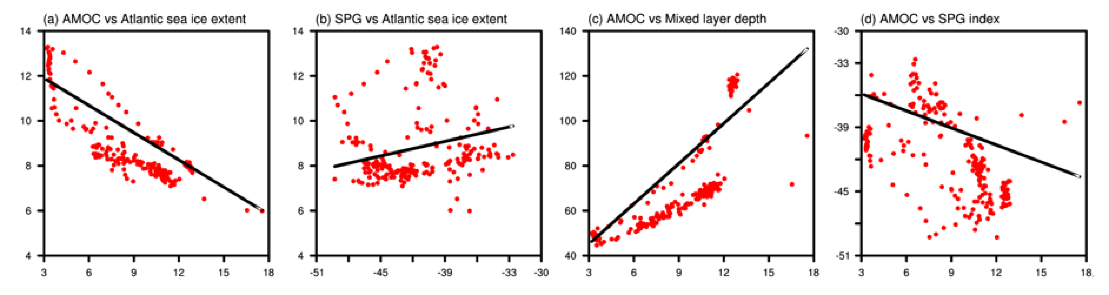
3. Results and Discussion

Figure 1a–h show the temporal evolution of sea ice, mixed layer depths, Atlantic Meridional Overturning Circulation (AMOC), and subpolar gyre (SPG) index for the past 22 ka. We found that the Northern Hemisphere (NH) sea ice extent (which means more than a 15% sea ice concentration) and the NH quasi-permanent sea ice (which represents more than a 90% sea ice concentration) analogous to perennial sea ice vary coherently with a Pearson correlation coefficient of 0.93 (p = 0) (Figure 1a,b). The NH sea ice reduced during the NH warm BA period and extended during the NH cold LGM, HS1, and YD periods.
Meanwhile, due to the prescribed lower ice sheet topography, the NH sea ice coverage is extended after 13.1 ka compared to the LGM period. The TraCE-21ka experiment changed the height and breadth of the continental ice sheets once every 500 years following the ICE-5G reconstruction [9]. The ICE-5G reconstruction coastlines at the LGM were altered at 13.1 ka due to the retreat of the Fennoscandian Ice Sheet from the Barents Sea and at 12.9 ka by the opening of the Bering Strait. These modified coastlines increased the NH’s ocean surface area and caused a corresponding increase in sea ice coverage. Meanwhile, the emergence of Hudson Bay also changed the Holocene coastlines at 7.6 ka. The last coastal adjustment happened at 6.2 ka with the entrance of the Indonesian through flow, following which the TraCE-21ka simulation adopted the present-day coastlines.
We analyzed the sea ice evolution in the Atlantic Ocean sector to comprehend the dynamics of sea ice with the AMOC and SPG. Similar to the NH sea ice, we found that the Atlantic sea ice extent and quasi-permanent sea ice coverage have a strong positive correlation (r = 0.93; p = 0) (Figure 1c,d). The Atlantic sea ice also reduced during the NH warm BA period and extended during the NH cold LGM, HS1, and YD periods. However, unlike the NH sea ice coverage, the Atlantic sea ice coverage decreased significantly since the YD cold period.
The global Meridional Overturning Circulation closes at the NH high-latitude seas. Here, the winter-time deep convections in mixed layers form deep waters, eventually forming North Atlantic deep water (NADW) and the upper limb of the MOC. We found that the average and maximum mixed layer depth vary coherently with a Pearson correlation coefficient of 0.89 (p = 0) (Figure 1e,f). The mixed layer depth decreased during the HS1 and YD periods, which indicates reduced deep convection and a weakened AMOC strength (Figure 1g), which is in agreement with previous studies [10,11,12,13]. The reduction in the AMOC strength weakened the upper meridional overturning cell, inducing a bipolar seesaw response [11], and it reduced the northward meridional heat transport. The reduction in northward heat transport resulted in extended Atlantic sea ice coverage (Figure 1c,d). Thus, a deeper mixed layer depth representing a stronger AMOC and reduced sea ice coverage is found during the LGM, BA, and MH periods and from the 2 ka to 1 ka (Figure 2a,c,e,f) periods. On the other hand, a shallower mixed layer depth representing a weakened AMOC and extended sea ice coverage is found during the HS1 and YD (Figure 2b,d) periods.
According to Fairbanks [14], the sea level rise of around 20 m in roughly 300–500 years characterizes Meltwater Pulse 1A (MWP-1A), which caused the BA warm period. The 20 m sea level rise is attributed to NH origin [9], which resulted in the AMOC collapse in the climate models [15]. However, studies have disclosed that more than 5 m of NH meltwater forcing caused the AMOC to shut down completely, whereas proxy records indicate a weakened AMOC [10]. Therefore, the TraCE-21ka used 20 Sverdrup (Sv; 1 Sv = 106 m3s1) NH meltwater forcing (freshwater flux) and 60 Sv Antarctic meltwater forcing during the MWP-1A. Right after the 20 Sv injection, the experiment abruptly terminated the meltwater forcing. We found an anomalous overshooting of the AMOC and mixed layer depth and reduced Atlantic sea ice coverage to the abrupt stopping of prescribed unrealistic meltwater forcing during the BA period. The invigoration of the AMOC abruptly increased the northward heat transport [3], resulting in the lowest Atlantic sea ice coverage during the 22 ka period (Figure 3).
We performed a linear regression between the climate variables at 95% confidence intervals to understand their relationship throughout the past twenty-two thousand years. The Atlantic Meridional Overturning Circulation (AMOC) index and Atlantic sea ice extent are significantly negatively correlated with a Pearson correlation coefficient of −0.84 (p = 0) and a regression coefficient of −0.40 (standard error (SE) = 0.02) (Figure 4a). Thus, the AMOC strength decreases as the Atlantic sea ice coverage expands because the expanded sea ice covers the site of deep convection (shallower mixed layer), which inhibits deep water formation and weakens the AMOC.
Meanwhile, the subpolar gyre (SPG) index and Atlantic sea ice extent are spread out with an insignificant (p = 0.06) Pearson correlation coefficient of ≈0.13 and a regression coefficient of ≈0.11 (SE = 0.03) (Figure 4b). Although the SPG and sea ice are out of phase during the HS1 and YD Northern Hemisphere cold periods, the detailed variability needs further investigation.
We found that the AMOC index and average mixed layer depth are in phase (r = 0.78; p < 0.005) significantly and have a regression coefficient of 5.97 (SE = 0.3) (Figure 4c). Thus, a deeper mixed layer depth results in an increased deep convection and a strengthened AMOC. The North Atlantic current transports heat and salty water to the SPG, and the SPG transports cold fresh water into the AMOC. The AMOC and SPG index are found to be in phase significantly, with a Pearson correlation coefficient of 0.53 (p < 0.005) and a regression coefficient of 0.53 (standard error (SE) = 0.07) (Figure 4d). Moreover, after removing the unrealistic AMOC index from 14.5 ka to 14.3 ka, the regression coefficient increases to 0.78. Consequently, the SPG strength increases as the AMOC strengthens.
This study shows that the sea ice coverage, AMOC, and SPG strength were closely interconnected in the subpolar Atlantic throughout the past 22 ka.

Author Contributions

Conceptualization, G.M. and S.V.E.; methodology, G.M. and S.V.E.; software, G.M.; formal analysis, G.M.; investigation, G.M.; writing—original draft preparation, G.M. and S.V.E.; writing—review and editing, G.M. and S.V.E.; visualization, G.M.; supervision, G.M. All authors have read and agreed to the published version of the manuscript.

Funding

This research received no external funding.

Institutional Review Board Statement

Not applicable.

Informed Consent Statement

Not applicable.

Data Availability Statement

The output data from the TraCE-21ka experiment are publicly accessible at https://www.earthsystemgrid.org/project/trace.html. The data were last accessed on 27 August 2023.

Conflicts of Interest

The authors declare no conflicts of interest.

References

  1. Buckley, M.W.; Marshall, J. Observations, inferences, and mechanisms of the Atlantic Meridional Overturning Circulation: A review. Rev. Geophys. 2016, 54, 5–63. [Google Scholar] [CrossRef]
  2. Broeker, W. The Great Ocean Conveyor. Oceanography 1991, 4, 79–89. [Google Scholar] [CrossRef]
  3. Liu, Z.; Otto-Bliesner, B.L.; He, F.; Brady, E.C.; Tomas, R.; Clark, P.U.; Carlson, A.E.; Lynch-Stieglitz, J.; Curry, W.; Brook, E.; et al. Transient simulation of last deglaciation with a new mechanism for Bolling-Allerod warming. Science 2009, 325, 310–314. [Google Scholar] [CrossRef]
  4. Liu, W.; Liu, Z.; Cheng, J.; Hu, H. On the stability of the Atlantic meridional overturning circulation during the last deglaciation. Clim. Dyn. 2014, 44, 1257–1275. [Google Scholar] [CrossRef]
  5. Klockmann, M.; Mikolajewicz, U.; Kleppin, H.; Marotzke, J. Coupling of the Subpolar Gyre and the Overturning Circulation During Abrupt Glacial Climate Transitions. Geophys. Res. Lett. 2020, 47, e2020GL090361. [Google Scholar] [CrossRef]
  6. Häkkinen, S.; Rhines, P.B.; Worthen, D.L. Warm and saline events embedded in the meridional circulation of the northern North Atlantic. J. Geophys. Res. 2011, 116. [Google Scholar] [CrossRef]
  7. Li, C.; Born, A. Coupled atmosphere-ice-ocean dynamics in Dansgaard-Oeschger events. Quat. Sci. Rev. 2019, 203, 1–20. [Google Scholar] [CrossRef]
  8. Michel, S.L.L.; Swingedouw, D.; Ortega, P.; Gastineau, G.; Mignot, J.; McCarthy, G.; Khodri, M. Early warning signal for a tipping point suggested by a millennial Atlantic Multidecadal Variability reconstruction. Nat. Commun. 2022, 13, 5176. [Google Scholar] [CrossRef] [PubMed]
  9. Peltier, W.R. Global glacial isostasy and the surface of the ice-age Earth: The ICE-5G (VM2) Model and GRACE. Annu. Rev. Earth Planet. Sci. 2004, 32, 111–149. [Google Scholar] [CrossRef]
  10. McManus, J.F.; Francois, R.; Gherardi, J.M.; Keigwin, L.D.; Brown-Leger, S. Collapse and rapid resumption of Atlantic meridional circulation linked to deglacial climate changes. Nature 2004, 428, 834–837. [Google Scholar] [CrossRef] [PubMed]
  11. Barker, S.; Diz, P.; Vautravers, M.J.; Pike, J.; Knorr, G.; Hall, I.R.; Broecker, W.S. Interhemispheric Atlantic seesaw response during the last deglaciation. Nature 2009, 457, 1097–1102. [Google Scholar] [CrossRef] [PubMed]
  12. Mandal, G.; Yu, J.-Y.; Lee, S.-Y. The Roles of Orbital and Meltwater Climate Forcings on the Southern Ocean Dynamics during the Last Deglaciation. Sustainability 2022, 14, 2927. [Google Scholar] [CrossRef]
  13. Anderson, R.F.; Ali, S.; Bradtmiller, L.I.; Nielsen, S.H.H.; Fleisher, M.Q.; Anderson, B.E.; Burckle, L.H. Wind-Driven Upwelling in the Southern Ocean and the Deglacial Rise in Atmospheric CO2. Science 2009, 323, 1443–1448. [Google Scholar] [CrossRef] [PubMed]
  14. Fairbanks, R.G. A 17,000-year glacio-eustatic sea level record: Influence of glacial melting rates on the Younger Dryas event and deep-ocean circulation. Nature 1989, 342, 637–642. [Google Scholar] [CrossRef]
  15. Stouffer, R.J.; Yin, J.; Gregory, J.M.; Dixon, K.W.; Spelman, M.J.; Hurlin, W.; Weaver, A.J.; Eby, M.; Flato, G.M.; Hasumi, H.; et al. Investigating the Causes of the Response of the Thermohaline Circulation to Past and Future Climate Changes. J. Clim. 2006, 19, 1365–1387. [Google Scholar] [CrossRef]
Figure 1. The time progression of (a,c) the Northern Hemisphere (~35° N–~87° N) (NH) and (b,d) Atlantic (~35° N–~87° N and ~83° W–0° W) sea ice extent (black) and quasi-permanent sea ice (red). The Atlantic mixed layer depths: (e) average (black) and (f) maximum (red), (g) AMOC index (maximum stream function value below 500 m and between 20° N and 65° N [8]) (black), and (h) subpolar gyre (SPG) index (absolute minimum barotropic streamfunction with ranges of ~32° N–87° N and 90° W–0° W) (red) for the past twenty-two thousand years.
Environsciproc 27 00003 g001
Figure 2. The NH mixed layer depth (color shaded; units are in meters) overlying the sea ice extent (green contour line) and quasi-permanent sea ice coverage (black contour line). (a) LGM period from 20 to 19 ka, (b) HS1 period from 16.5 to 15.5 ka, (c) BA period from 14.6 to 13.6 ka, (d) YD period from 12.6 to 11.6 ka, (e) MH period from 6 to 5 ka, and (f) the period from 2 to 1 ka.
Environsciproc 27 00003 g002
Figure 3. The NH mixed layer depth (color shaded; units are in meters) overlying the sea ice extent (green contour line) and quasi-permanent sea ice coverage (black contour line) during the 14.4 ka period.
Environsciproc 27 00003 g003
Figure 4. The linear regression at 95% confidence intervals: (a) Atlantic Meridional Overturning Circulation (AMOC) index and Atlantic sea ice extent, (b) subpolar gyre (SPG) index and Atlantic sea ice extent, (c) AMOC index and average mixed layer depth, and (d) AMOC and SPG index.
Environsciproc 27 00003 g004
Disclaimer/Publisher’s Note: The statements, opinions and data contained in all publications are solely those of the individual author(s) and contributor(s) and not of MDPI and/or the editor(s). MDPI and/or the editor(s) disclaim responsibility for any injury to people or property resulting from any ideas, methods, instructions or products referred to in the content.

